Shipston-on-Stour Neighbourhood Plan
|
|
|
- Jessica Snow
- 5 years ago
- Views:
Transcription

1 Shipston-on-Stour Neighbourhood Plan Our town, our plan, our future. Submission Draft for Final Local Consultations
2 Document 1: the Neighbourhood Plan Document 2: the consequent local projects Document 3: mandatory supporting documents Document 1: the Neighbourhood Plan 1. Introduction 1.1 Neighbourhood Plans: what they are about, the procedure 1.2 The plan-making process 1.3 The end product 2. Converting evidence into policies 2.1 The town: overview past and present 2.2 The matters of most concern 2.3 What should be improved? 2.4 Fact-finding and assessments: the evidence 3. Policies 3.1 Context and conformity 3.2 Creating a stronger local economy 3.3 Adequate infrastructure and community facilities 3.4 Dealing better with flooding risks 3.5 Protecting a valued environment 3.6 Meeting housing requirements 3.7 The policies map 4. Appendices 4.1 Glossaries of terms 4.2 List of references and background information 4.3 Acknowledgements 2

3 1. Introduction 1.1 Neighbourhood Plans: what they are about, the procedure 1.2 The plan-making process 1.3 The end product 3
4 1. Introduction 1.1 Neighbourhood Plans what they are about, the procedure Why the plan is important A Neighbourhood Plan i guides the future development, regeneration and conservation of a designated local area - in this case the Parish of Shipston-on-Stour. It deals with land, buildings and related physical infrastructure. This plan adds the local dimension to the lately adopted District-level Core Strategy ii plan. The local policies have resulted from thorough community engagement, to establish what matters, and why. When effectively applied, as part of the Development Plan, to the consideration of future development proposals the local policies in this plan will make a difference. The policies will also stimulate on-the-ground projects to bring about some important local improvements. Having an adopted plan brings with it an enhanced amount of funding through the Community Infrastructure Levy iii, to be spent locally upgrading relevant infrastructure and community facilities. Local priorities Maintaining the economic vitality and local employment potential of the town, especially the town centre shops and services; Creating the right amount, types and tenures of housing, particularly affordable housing, to meet local needs; Better infrastructure and social facilities to match the needs of the community and local economy; and Conserving yet making the local environment more accessible and useful for well-being and recreation Document 1 comprises the statutory Neighbourhood Plan. The consequent on-the-ground projects are within Document 2 as they are not part of the formal Neighbourhood Plan. Document 3 contains the mandatory supporting submissions for the Neighbourhood Plan, including the Consultation Statement. This Document 1 starts with an explanation of the purpose, procedure and end product. Section 2 is about the gathered evidence, and how it was converted into objectives and policies by way of analysis and consultations. Section 3 contains the plan s objectives and policies, the heart of the plan. There are explanations as to why policies are appropriate, and the differences they will make when applied. A rigorous process The decision to produce the plan was taken by Shipston-on-Stour Town Council [the Town Council] in November After approval by Stratford-on-Avon District Council [the District Council] of the plan-making proposal the Town Council became in April 2013 the qualifying body responsible for the plan. The plan-making was to be done by a team of community volunteers. A rigorous process has been followed; the resulting policies derive from systematic research and the analysis of facts. Some supplementary studies and surveys were commissioned to inform important issues such as the strength of the local economy, local housing needs, and the value and significance of the local landscape. Much use was made of research commissioned by the District Council as evidence for the then emerging draft Core Strategy. 4

. Provide feedback. Ongoing community engagement (aims, content, detail). 5. Building the evidence base Review existing evidence. Identify gaps in evidence.")
5 The route to the plan 1. Getting started Clarify why a plan is needed. Publicise the intention to produce a plan. Identify and contact key local partners. Dialogue with the local planning authority. Produce a project plan with costings. 2. Neighbourhood area Determine the neighbourhood area. Submit neighbourhood area proposal. LPA consults. LPA approve. 3. Neighbourhood forum Put together prospective neighbourhood forum. Submit forum proposal. LPA consults. LPA determines area. 4. Community engagement & involvement Publicity. Engage local partners. Initial community engagement (broad issues). Provide feedback. Ongoing community engagement (aims, content, detail). 5. Building the evidence base Review existing evidence. Identify gaps in evidence. Compile new evidence. Analysis of evidence. 6. Themes, aims, vision, options Identify key issues and themes. Prioritise issues and themes. Develop key aims. Look at options. 7. Writing the plan Policies, proposals, site allocations. Consider sustainability, diversity, equality, delivery. 8. Consultation Consultation on plan. Amend plan. 9. Submission Submit to LPA. LPA publicises. 10. Independent examination LPA appoints examiner. Examination takes place. Examiner's Report. 11. Referendum Publicise referendum. Referendum. 12. The plan is made Engaging with the community There has throughout been a serious and effective effort to engage with the local community: to find out what matters to them, why, and what they think are the big issues and opportunities. As the policies emerged there was in-depth contact by way of events, surveys, and particular contacts, such that individuals and organisations have contributed and endorsed the directions being taken and the views that have been formed. The work has been open to scrutiny, with written records of meetings and the main documents published on a dedicated website, and also made available in hard copy by the Town Council. 5
6 Plan-making regulations There are certain legal and technical requirements to be met, including the basic conditions iv, and there must be proof that those requirements have been met. This is covered within the companion Document 3. This document is the submission draft plan. The District Council will check that it meets the procedural requirements. They will advertise the plan so that interested parties may comment. They will appoint an independent professional examiner who will consider whether the plan is sound and meets the basic conditions. A local referendum Once confirmed as a sound plan, possibly having taken on board some recommended modifications, it will be put to Parish residents in a referendum v. If a majority approves it will be adopted, or made, by the District Council as a component of the overall Development Plan vi for the District. It will then sit alongside the strategic objectives and policies within the Core Strategy. Conforming to the Core Strategy The Neighbourhood Plan provides the bottom-up local policies mindful of what matters most to the local community, whilst the Core Strategy provides the top-down District wide policies, and a link to National planning policies vii. The examination will check, amongst other matters, that there is general consistency or conformity between the different levels of policies. Site allocations This plan covers what are known as site allocations, as agreed in July 2014 with the District Council. It was felt by the group creating the plan that this task should be included, rather than left to the District Council to do in a District-wide site allocations development plan viii. One of the housing policies identifies particular sites where for stated reasons the principle of housing development to meet future local needs is accepted, subject to other relevant policies being adhered to. Local concerns about the recent rate and scale of development The emerging Neighbourhood Plan has had to deal with considerable and continuing local concern about the scale of development in the last few years, particularly about major new housing proposals. The plan-making has had to accept planning decisions as and when they were made, and throughout to take an objective stance. The resulting policies reflect the probable further substantial growth of population, more dwellings, possibly more commercial development, and a consequent increased demand on infrastructure and community amenities. See the map for the location of these commitments. 6
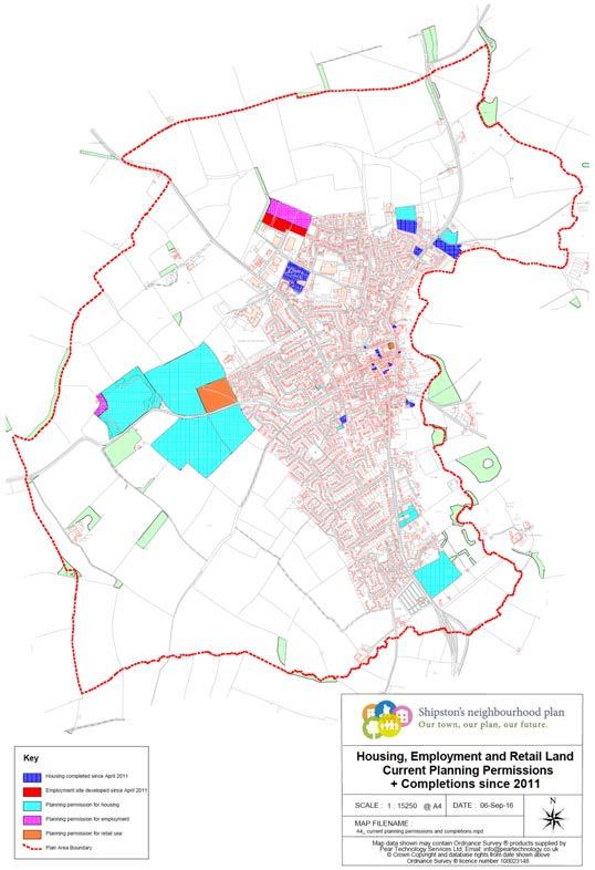
7 The Commitments Map 7
8 Influencing and managing change This plan puts in place justified local policies that, if used effectively, will help to manage changes by influencing future planning decisions for the better. As a by-product the plan will initiate some important on-the-ground projects that will locally make a big difference. 1.2 The plan-making process Box 1 shows the process that has been followed. There have been three main aspects: Meeting the legal and procedural requirements as set out in the regulations and guidance; Gathering and assessing evidence, converting that information into policies and proposals, and writing-up the plan; and Throughout engaging effectively with the community and stakeholders such as property owners [see the Consultation Statement within Document 3 for full details]. To get this far has involved a lot of work. It has taken over three years. This may with hindsight seem slow progress but it very much reflects a methodical and thorough approach. Appendix 4.2 lists the most important reference documents. These and the many related published reports and notes should be referred to by those seeking greater detail There have been six key stages of work: Stage One: Getting the act together The first stage was from Getting Started up to Neighbourhood Area designation. This happened in late 2012 up to June The Town Council recognised the opportunity to create a plan, and sought community views as to what they thought were the important issues, and whether producing a Neighbourhood Plan would be worthwhile. Some work was also done to clarify what would be involved, what it would cost, and what funding support would be available. Community views were positive, and the Town Council in November 2012 considered a scoping report ix and decided to sponsor the plan-making work. An application was put to the District Council and in April 2013 approval to proceed was given Stage Two: allocating the work The next stage was to seek help from the community and to get volunteers together. This happened between May 2013 and September 2013, starting with a launch announcement at the 2013 Wool Fair event. Project direction and management arrangements were also put in place. A Steering Group was set up by the Town Council to deal with management, funding, and ensuring the work and the way it was done met appropriate standards Stage Three: focussing on the most important issues The volunteer community group agreed that they would sub-divide the work into four topics: environment; economy; community infrastructure and facilities; and housing. Topic leaders were identified for each theme. It should be noted that in late 2015 the community group added a flooding topic in recognition of the importance of that issue as had emerged during the ongoing work Stage Four: research and assessments The big task was to build what is called the evidence base x. In simple terms this was the gathering and in-depth analysis of the main facts and considerations: finding out what locally has been happening, and understanding what such trends would mean over the plan period and a bit beyond. This task, for a number of reasons, took about 18 months to complete. In part this was because some supplementary research had to be commissioned, such as a survey of local businesses, and a Housing 8

9 Needs Survey. In part it was because ongoing work on the evidence base for the emerging Core Strategy was providing important information. Mostly it was because there was a lot to find out, and engaging with the many local interests and organisations took time. The important thing is that this work was done rigorously, it was well organised, and thorough. The main published output from that work was a set of Audit and Issues Reports xi covering the four working topics including the added flooding topic, which were published at different times over the period May 2015 to September Stage Five: deciding what the aims and objectives should be Overlapping with the concluding actions on the evidence base was work by the community group to consider the strategic aims that would guide the policies and proposals. In large part this came down to considering the expressed opinions of the wider community in the light of the emerging facts, issues and opportunities. Of particular note were community workshops in February 2015 and March 2015 to define a vision for the development of the town. See Text Box Stage Six: first draft policies and the reasons for them The published Audit and Issues Reports then formed the basis of a set of workshop meetings to identify the most important findings and implications within and across the themes. There was due consideration of the previously defined vision and strategic aims to ensure that what was emerging as draft policies and proposals was relevant, and would make a difference if and when applied. These workshops were held in October 2015 and November The product from each topic leader after those team workshops was a concise document setting out first draft policies, with preliminary objectives, and explanations as to why the policies were appropriate. Continuous community engagement Throughout the work on the evidence base there was ongoing publicity and community engagement, not least to check that new considerations were not emerging. Once the first draft policies had been written the community engagement stepped up a gear. The main events in December 2015 and January 2016 were well-publicised community and stakeholder open days when the plan-making team displayed and presented their work. The level of attendance, interest shown and quality of feedback was very good. There was much recognition of the effort that had been made by the plan-making team, and confirmation that the draft policies and proposals, and the guiding vision and strategic aims, were all heading in the right directions. 9
10 Community questionnaire To further test the draft policies and proposals an in-depth questionnaire was delivered to all households within the Parish. Advice about the questions and process was sought from a market research professional. The questions were a mix of again requesting views about what matters and why so, and some focussed on the emerging plan to check some specific aspects of the draft policies. The level of response - about 25% - was very good for this type of planning survey. The survey findings were published in April 2016, for details see the Consultation Statement within Document 3. Modifications following feedback During April 2016 to June 2016 the community team modified, as and where required, the draft policies and proposals in the light of the wider community and stakeholder feedback. Also the opportunity was taken to get initial feedback from the District Council about the draft policies and proposals, partly to check that there was no inappropriate content, partly to cross-check against the emerging Core Strategy and the ongoing outcomes of the examination-in-public of that development plan. There was also some supplementary work for the community team to do on the housing and environment draft policies and proposals. This involved checking the highways access feasibility of some of the potential site allocations, and commissioning a professional report on landscape sensitivities and using that report to build a case for Local Green Space xii designations. Finalised draft policies and proposals have been converted into this Submission Draft Plan document. 1.3 How the plan will make a difference Using the policies Policies are statements of the principles that particular kinds of proposed development must satisfy in order to obtain planning permission. A Policies Map shows designated areas and/or site allocations, either where particular types of development or activity are intended to take place, or areas of restraint where development is discouraged unless justified by very special circumstances. Policies will be applied when development proposals are put together and submitted for planning permission. Applicants will know what locally is regarded as good policy and practice, and why, and should frame their proposals accordingly. When applications are considered by the local planning authority, and those they consult including the Town Council, and representations are duly made, the relevant Development Plan policies will apply. The policies within this plan carry considerable weight in this decision-making. The Town Council s aim was published in the 2014 Town Guide: A Neighbourhood Plan is in progress: once completed and agreed it will allow the Town Council to give a more informed contribution to the future development of the area and will also have the added benefit of funding from the Community Infrastructure Levy. These funds can be used for projects highlighted as needs within the Neighbourhood Plan. Subsequent on-the-ground projects The community plan-making group is of the view that there should be a continued project delivery role for that team, either leading, or working alongside the Town Council and other active public and voluntary sector organisations and action groups in the town. The projects outlined in Document 2 make reference to the likely leadership and delivery mechanisms. 10

11 2. Converting evidence into policies 2.1 The town: overview past and present 2.2 The matters of most concern 2.3 What should be improved? 2.4 Fact-finding and assessments: the evidence 11
12 2. Converting evidence into policies 2.1 The town: overview past and present A long history The town dates back to the 10th Century and a grant of land by the then King Edgar to the monks of Worcester Cathedral. Until the 1930s the town and parish remained an outlier of Worcestershire, with undeveloped land to the east across the river being in Warwickshire. This explains the one-sided geography of the town, with the river on the eastern boundary The town name means sheep wash reflecting the local importance of sheep farming in the rural economy. Also of note is the past importance of the town on a main route between Stratford-upon-Avon and Oxford, in time an important staging post with coaching inns, some such as The George remaining to this day. The town has a notable and distinctive central area with many fine old buildings and the old street pattern very evident. Serving a large rural area Located about 10 miles south of Stratford-upon-Avon in the Stour Valley, at the northern end of the Cotswolds, the town is at the heart of the most rural area of the District. A considerable number of nearby villages use the excellent range of shops, services and community facilities. This includes some nearby villages and hamlets in Gloucestershire, the county boundary being not far away. The designated Cotswolds Area of Outstanding Natural Beauty [AONB] is close by and the town is a gateway to that area, with leisure and tourism implications. A distinctive landscape The Stour Valley riverside and landscape is very attractive and much valued locally, with the town fringed to the west and south by prominent slopes and hilltops that open out towards the adjacent Cotswolds. To the north and east is the Feldon landscape, the less wooded, more upland equivalent of the better known Arden area. So the town s landscape setting, where Cotswolds meets Feldon, is certainly distinctive, and it has local characteristics that are recognised and seen as worth conserving. Flooding The topography and riverside setting does however have consequences. This is due to a large upstream catchment, with some steep slopes, and clay soils in the valley. Heavy rainfall means rapid runoff, a lot of water quickly accumulates, and the river rises rapidly and floods. Measures to improve flood resilience are very much on the local agenda. Population growth and implications The 2011 Parish population was just over 5000, which was a 62% increase since Perhaps more important has been the doubling in the number of dwellings over that time. This was the largest such increase of any settlement in the District. The town population has, in common with national and District trends, become on average older 50% aged over 50. There are health implications, such as a growing need for care accommodation, and the importance of fitness and wellbeing facilities. A weakened local economy The local economy has changed greatly in recent years. At the time of the 2001 Census the town had the highest proportion at 44% of people living and working in the same Ward of all the Main Rural Centres in the District. It was relatively self-contained in employment terms. That has changed significantly. Several manufacturing facilities that were major local employers have closed in recent years. Whilst the town s role as a shopping and services centre has been maintained, the need for those in employment to travel to jobs some distance away has increased substantially, as has the distance they travel. This mismatch between local jobs and a rising population is a key issue for this plan. 12

13 Supporting local businesses The relatively remote location of the town does not meet the commercial requirements of major employers. They typically need excellent transport accessibility and substantial sites for expansion or new facilities. Within the town some employment sites and buildings are available, and there are some good quality rural business parks nearby, but the economic reality is that a substantial uptake of large sites is unlikely to happen. This has several implications for the plan. The employment sites that remain need to be maintained, enhanced and promoted. Where there is demand from particular sectors or business types the provision of additional suitable and affordable business space needs to be encouraged. The town s shopping and services centre function needs to be strengthened and the retail offer improved, not least to meet the needs of more leisure and tourism visitors and an increasing local population. Re-using large sites A further consequence of the business closures has been the availability for re-use of some large sites. Of especial note are the large Norgren and Turbine Blading sites. The evident absence of demand for employment users has created opportunities for new housing, and in one case a retail development. These developments, and ones adjoining or near the Norgren site, are continuing the upwards trend in population, but not local employment. The implications figure heavily in the plan. Implications for local services and infrastructure The trends as noted, especially the increase in population and dwellings, had marked consequences for the infrastructure and community facilities and amenities in the town. The prevailing community view at the outset of work on the plan was that there was great pressure and this would get worse. Establishing the facts has been very important. The findings proved interesting. Some infrastructure, facilities and amenities are under-provided in capacity and quality now, let alone meeting additional demands from new developments in the pipeline. Other facilities and amenities are actually less stressed than the popular view indicated. 2.2 The matters of most concern There were regular requests for community views on what they saw as the main issues and opportunities for the town. The first such commentary was in late 2012 when the merits of creating a plan were being considered. As the evidence was subsequently gathered, and the policies and proposals emerged, regular checks were made with the community to ensure that new 13
14 issues were not being missed, and that the direction and emphasis was right. In late 2015 into early 2016 approval was sought for the emerging policies and proposals It was evident from this consultation that there were at the outset a few main concerns that the community very much wanted the plan to address, as in Text Box 1. Those concerns have not shifted over the duration of the plan-making. In fact, if judged by the April 2016 Household Questionnaire feedback those particular concerns have intensified. This is reassuring. It demonstrates the focus of the work has been good, and what the community expected to be addressed has been addressed The community group was convened around four themes or topics : economy; housing; environment; infrastructure and community facilities. The flooding issue was promoted in view of the significance to the town to be a fifth topic. This occurred in late 2015: the evidence about flooding had been included in the infrastructure and community facilities topic up to that point For each listed topic there was a lengthy and thorough fact-finding exercise, an audit. The resulting information was then assessed and a written commentary made on the main issues that had emerged from the fact-finding. 2.3 What should be improved? Workshop meetings were held in February and March 2015 to assess the community feedback to date and agree a preliminary future vision of the town in The idea was to provide an overall destination for the emerging policies and proposals. A set of working aims and objectives for the plan was also agreed. As the evidence was gathered and the issues assessed careful consideration was given as to how best achieve the vision and objectives. A working draft vision was published in April Preliminary Community Vision By 2031 Shipston-on-Stour will be a sustainable historic market town, in a rural riverside setting, providing excellent services for the community and the surrounding area. It will have successfully embraced its growth potential, and ensured that infrastructure and community facilities have kept pace, whilst retaining its local identity and distinctiveness. Strategic aims and objectives The underlying strategic aims and objectives as identified in April 2015 were: Develop the strong sense of place, community and local identity, its character and setting as an historic riverside market town; Maintain and strengthen the role and competitiveness as a Main Rural Centre serving the town and surrounding area and a wider catchment, with a strong retail offer and a broad mix of local and visitor services, amenities and facilities; Champion business growth, employment opportunities, new economic activity and economic diversification whilst protecting and enhancing the natural environment and heritage assets; Enhance, exploit and celebrate the riverside setting and the historic cultural, economic and amenity role that the River Stour has had in shaping the town s development; Manage growth whist protecting the town s integrity, its valued rural setting and green surroundings, and ensure that development respects and enhances the setting, visual identity, and the wider environment; Define settlement boundaries around the fringes of the town to accommodate growth but conserve the landscape and riverside setting; Reduce flood risks to people and property from all sources across the whole plan area; 14


15 Address the challenges of an ageing population, provide better opportunities and amenities for younger people, and foster a sense of community wellbeing; Ensure that future housing needs are met in a managed, balanced and well-designed way, and that local needs and affordability are priorities; Retain and add to the wide range of excellent services the town currently hosts, and address the challenge that rapid housing growth is bringing about for the physical and social infrastructure; and Improve connectivity within the town, with the surrounding communities, and the wider region. The benefit of having a long and ambitious list was twofold. Based on the community feedback to date the list summarises the expressed hopes and concerns. The list also gave structure to the gathering and assessment of the evidence. This is best seen by reading the published set of Audit and Issues Reports, as outlined in Section 2.4 below. Refining the aims and objectives After the evidence had been assessed, and initial thoughts were being given to potential polices, the vision statement was re-visited and made shorter and precise. This improved version was issued in December 2015, alongside the first draft policies and the supporting evidence from which those policies and proposals derived. This is the basis of the first draft plan for the upcoming main community and stakeholder engagement phase. 15
16 The 2031 Vision A sustainable, distinctive market town retaining its rural setting and historic character Realising its full potential for the benefit of the community and visitors With supporting infrastructure and community facilities especially schools, services and healthcare Having flooding risks contained and minimised, and With housing growth limited to meeting the needs of the community. 2.4 Fact-finding and assessments: the evidence The Audit and Issues Reports The most important evidence findings are set out in detail within the published set of detailed Audit and Issues Reports. These documents were completed and published between May and September There are reports for each of the four topics. Flood risk had not at that time not been promoted to become a stand-alone topic, having been covered within the Infrastructure and Environment topic reports Each topic report contains references to the source material. This source material was a mix of already published information within the evidence base for the emerging Core Strategy; relevant recent published local factual information such as the draft Town Design Guide xiii ; new research done by the topic teams; and commissioned surveys about the local economy, local ecology and housing needs. The topic reports also identified the need for some supplementary research in some important areas and recommended how this could take place. This mainly applied to the Environment topic and making a sound case for policy-based area designations to conserve the distinctive and valued landscape setting xiv The main issues and opportunities identified from the assessed evidence were then summarised and listed. This was an important action, being the link between the evidence and the emerging draft policies and proposals. A matrix xv setting out the issues, opportunities and priorities within and across the topics was prepared and published. This document was used as the basis of topic workshop meetings held in September and October Creating first draft policies The outcome of the meetings in February and March 2015 to set a development vision for the town and a set of strategic aims was re-visited. The topic leaders used the outputs from those topic workshops to create the first draft policies and proposals document. This was published and formed the basis of well-publicised community Open Day events held in December 2015 and January The must do priorities The September and October 2015 topic workshop meetings identified the 7 must do priorities that the policies would need to tackle A list was also made of 15 essential supporting actions. Some of the listed supporting actions would figure as policies. Some were markers for projects subsequent to the policies. 16
17 The 7 priorities for action 1. Create a more vital and functional town centre as the heart of the local economy, with improved traffic management and better pedestrian safety This ambitious objective will be met by a robust policy basis in this plan and the adopted Core Strategy, and a substantial consequent project. That project will require effective leadership, adequate funding, and will need the collaboration of local businesses, their representative groups, and technical and management actions from the Highways Authority, and both the District and Town Councils. This project is also very important to priority 7 below. 2. Retain existing business space, and create more and better business space to meet local needs and especially help start-ups and small business growth. This objective will be met by positive policies, and encouraging the commercial re-use and creation of business space meeting identified local needs. Realism will apply. There are limitations to the scale and nature of the future local economy. That said local opportunities must be taken to reduce the need to travel to work. There will be a strong overlap with priority 7 below. 3. Improve flood resilience and the performance of surface water drainage. This objective will be met by applying the robust policies and infrastructure commitments within the adopted Core Strategy. The supporting local policies in this plan will ensure that development is not compromising flood resilience measures, and that land and highways drainage continues to be fully functioning and properly maintained. A future local project is identified: a technical survey so that the ownerships, capacity and condition of the surface water drainage system is confirmed. The baseline information can then inform emerging development proposals, and help to assess the adequacy of what is proposed when planning applications are considered. 4. Make the riverside a more attractive, valued and functional community asset. Meeting this objective will require a consequent project, in support of a number of related objectives and policies, mainly 3, 6 and 7. There is overlap too with supporting action 1 as below. As the river is on the Parish boundary there will need to be collaboration with land owners in neighbouring Parishes. Leadership may well come from enlarging the existing riverside walk Working Group of the Town Council. 5. Improve and update the town s infrastructure and community facilities to adequately meet current and future needs. This objective will be met by the application of policies and consequent infrastructure commitments within the adopted Core Strategy. The local task is to monitor those commitments and to ensure that funding and delivery meets expectations. This will require the Town Council to make appropriate representations about planning applications. Monitoring will be required to ensure agreed developer contributions are spent making the infrastructure upgrades, at the right times. This will include dealing with a backlog of improvements as identified in this plan and the Core Strategy. A policy is included. 6. Conserve and manage the town s historic heart and the river valley landscape and setting. This is a set of objectives all to do with managing development pressures without unduly compromising the fine heritage and landscape assets of the town. Protection for the historic town centre comes from applying the forceful policies in the adopted Core Strategy and long established conservation planning safeguards. This will be locally bolstered by the completion of a Town Design Statement. When consequent projects are undertaken, in particular as 1 above, meeting conservation requirements will figure large in the changes being considered. The town s landscape and setting will be protected and managed by strong local policies and Local Green Spaces designations. Expansion of the built-up area has reached the point where further outwards growth will unacceptably compromise the adjoining fine landscape, especially to the west. The policies and designations in this plan are based on detailed research and technical assessments, and clear evidence that the community uses and values what adjoins. The 17

18 recorded shortfall of public amenity land within the town, and very few opportunities to increase it, makes the greater use of the adjacent countryside an imperative. If that countryside is compromised or under threat that would be an own goal. Hence the direction this plan is taking. There will also be consequent projects in support of this objective, see supporting actions 1, 5 and Strongly push the tourism development agenda to create local employment. This objective will be achieved by applying both the robust policies in the adopted Core Strategy and reinforcement by local policies within this plan. There is some overlap with priority 1, and the potential to make the town a more attractive and functional destination for leisure and tourism visitors is recognised. More visitor accommodation will be encouraged, building on recent and ongoing investments in the town centre. Several of the consequent projects bear on this objective, in particular supporting actions 1, 4 and 5. 18
19 The 15 essential supporting actions The method by which each action will be achieved is listed. The options are through the application of policies, by way of designating areas [as shown on the policies map], or as a result of consequent projects [not part of the plan]. 1. Designate northern and southern public amenity wellbeing areas to bolster existing community assets, providing good pedestrian access and more structural landscaping, to encourage recreation and enjoyment. This objective will be realised through the designation of two defined land areas as shown on the policies map. Both areas are already mostly in public ownership and public access will be increased through access and use agreements with private owners and operators. 2. Conserve existing employment site allocations This objective will be realised through a realistic policy 3. Publish clear and town-specific design guidance to support and enhance conservation aims This objective will be delivered by a project for the resumption and conclusion of work on a Town Design Statement resulting either in the adoption of a publication as supplementary planning guidance or it being embodied within an updated Neighbourhood Plan. 4. Create more and better town centre car parking This objective will be realised through a technical project most likely created and managed by a community action group working in collaboration with the County Council and the District Council. It will be closely linked to actions from Priority Achieve better, safer and more obvious pedestrian and cyclist connections between town and country and within town This objective will be realised through a technical project as 4 above; there may be a single project for both. 6. Designate Local Green Spaces to protect the valued slopes, hilltops and riverside around the town edge This objective will require a policy and the formal designation of defined Local Green Spaces on the policies map. There will be a consequent project to improve and maintain community access by public footpaths and bridle tracks across the designated areas in conjunction with land owners and the County Council. 7. Designate edge-of-settlement areas for limited additional development that is suitably located and well designed This objective will be met through the allocation of the identified sites on the policies map and consequent actions by landowners and developers. 8. Subject to meeting good design objectives encourage the more intensive and mixed-usage of the existing built areas especially in and around the town centre This objective will be met by a policy and as a project, the latter being the conclusion of action 3 as above 9. Respond to identified future local needs for a continuing supply of affordable housing This objective will require a project for the periodic updating and application of the Housing Needs Survey. The survey findings will influence decisions on future housing development proposals. There may also be a consequent future need to revise allocated development areas to ensure the capacity exists. 10. Increase and continue the supply of a range of housing meeting the needs of older persons This objective will be achieved by applying a policy. 19

20 11. Support near term actions that will provide a new and larger medical centre This objective may well be achieved as part of the planning obligations relating to ongoing mainly residential developments in Campden Road. If not, an alternative solution will be required. 12. Respond to the possible medium term need for an enlarged primary school Should a definite case be made for an enlarged school, a site will have to be identified. Meeting this requirement may figure in a future update of the Neighbourhood Plan. 13. To improve wellbeing significantly increase the area of leisure and amenity green spaces within and adjoining the town to meet national space standards. This objective will be realised by the designations and consequent projects as listed 1, 5 and 6 above 14. Consider the beneficial re-use of the vacant Turbine Blading employment site and adjoining vacant land, and more intensively use the adjoining employment sites, including mixed-use possibilities This objective will be met by applying policies as 8 above, and by a consequent project undertaken to inform the future 2021 onwards updating of this plan. This project will create a development brief for the upper and lower Tilemans Lane employment areas, the aim being to review needs, allocations, and identify the optimal future land-uses. This project will likely be led by the District Council working in collaboration with land owners and tenants. 15. Designate a local nature reserve site. This objective will be achieved by a policy and designation as identified on the policies map, and subsequent community group actions in collaboration with the land owner. 20
21 3. Policies 3.1 Context and conformity 3.2 Creating a stronger local economy 3.3 Adequate infrastructure and community facilities 3.4 Dealing better with flooding risks 3.5 Protecting a valued environment 3.6 Meeting housing requirements 3.7 The policies map 21
22 3. Policies 3.1 Context and conformity This section contains local policies that will influence and help to manage development over the plan period. There are five sets covering the range of topics as listed in Section 1.2. Each policy is introduced with an objective, and concluded by an explanation of why the policy is appropriate given local circumstances. Some policies require land areas or specific sites to be shown on a policies map Some policies provide a basis for subsequent projects, on-the-ground actions that will make a big difference, and bring about changes in line with the directions the plan is taking. Document 2 is about those projects: it is not a formal part of the plan Each set of policies opens with a text box summarising the higher level position with the National Planning Policy Framework [the Framework]. The numbers in brackets reference particular paragraphs. Similarly the adopted Core Strategy is referenced. The numbers in brackets reference particular policies The local policies are in general conformity with that policy context, and respond to the particular local circumstances as explained. The Core Strategy contains a vision of Shipston-on-Stour by 2031: the town will have strengthened its local economy with the expansion of existing companies and the attraction of new business. The town s proximity to both Stratford-upon-Avon and the Cotswolds AONB will have contributed to its enhanced retail, tourism and visitor role. Enhancements will have been made to the quality of the built environment of the town centre. 3.2 Creating a stronger local economy The headlines start with manufacturing plant closures and a considerable reduction in local jobs in recent years. This means that more of those in employment have to travel, and travel quite some distance on average A thriving town centre location for shops and services and community facilities meets the needs of town residents and a wider rural catchment. More might be done to support the retail offer, improve traffic movements and parking, and also uplift the central area s appearance. This will attract more visitors, and encourage them to stay longer, and spend more. This also applies to leisure and tourism visitors: this sector locally offers good potential, and more visitor attractions and accommodation could be provided Existing businesses in the town centre and in the main business parks can be better supported, and the shortfall in accommodation needed for start-ups and growing small businesses needs attention. Not much land is locally allocated for employment in the Core Strategy - the relative remoteness of the town for large scale businesses is cited. This raises questions of how much employment land will be required in future, and the quality as well as quantity of commercial property, and how best to locally meet the needs of the sectors that do offer potential. 22
23 Higher level policies Relevant aims within the Framework are: Building a strong, competitive economy [18-22]; Ensuring the vitality of town centres [23-27]; and Supporting a prosperous rural economy [28]. The most relevant policies within the Core Strategy are: CS.22 retaining employment sites in commercial use unless such use is proven unviable; CS.23 larger retail proposals to be within the commercial core of the town; AS.6 diversify the local economy, promote the role of tourism, support new local enterprises, and sustain the vitality of the town centre; and CS.24 support for more tourism and visitor attractions and accommodation Policy EC1 Keeping land available for employment uses Objective: retain in employment use the undeveloped commercial land and vacant commercial buildings within the upper and lower Tileman s Lane business areas of the town. Policy: development proposals for other than the commercial use of land and buildings within the upper and lower Tileman s Lane employment areas will not be supported unless the proposed re-use meets particular local needs as identified elsewhere in this plan. 23
24 Explanation: The small area of land in the town allocated in the Core Strategy for employment use provides little local opportunity for additional business growth. Existing vacant commercial plots and buildings should as first choice be retained in business use. Measures to enhance and promote these commercial areas need to be considered by way of public intervention and support. Re-use proposals for other than employment use that meet particular local needs and policy requirements identified within this plan may be supported subject to a compelling case being made. The Tileman s Lane business areas and adjoining undeveloped land will in , assuming the owners and occupiers participate, be the subject of a planning project to identify by way of a development brief xvi the most appropriate and optimal future land-uses for the area. See Document 2 for more details Policy EC2 Creating more business space to meet local needs Objective: create additional business space to meet the needs of growing small businesses and business start-ups. Policy: proposals that create additional business space by new build, extensions, or conversions will be strongly supported, particularly so if re-using previously developed land. Explanation: a key finding of commissioned research for this plan was identifying a limited existing amount of affordable business space locally meeting the needs of small businesses and home workers who need larger workspaces. This research looked at the Parish area - it should be noted that nearby business parks are all currently full and void property is rare. Changes of use including permitted development, typically the re-use of commercial buildings as dwellings, has been reducing the commercial space available to such businesses. So proposals for creating additional business space, particularly in and around the town centre, will be welcomed Policy EC3 Retaining employment components within mixed-use xvii projects Objective: ensure that employment components within mixed-use developments are retained as such. Policy: proposals for changes of use to remove employment components from developments with planning permission will not be supported. Explanation: some of the major development proposals granted planning permission in recent years have included a commercial development component. This may have been to make a proposal more appealing, or it may have been for sound commercial reasons at the time. If a developer subsequently indicates there is no market interest, and proposes substituting additional dwellings, there should not be automatic approval. A valid case will need to be made, and the presumption that permission was originally granted for sound planning reasons should prevail until it is proven otherwise. This policy also applies to potential changes of use to existing commercial property in the town centre. Whilst recognising that some changes can occur as permitted development where not the case it will be argued that in the interests of maintaining a good amount and choice of employment space the buildings should remain in employment use. This policy will help to locally sustain the overall amount of employment land and business space that exists and is planned Policy EC4 Encouraging employment uses on the former Turbine Blading site Objective: encourage a significant business space component within the redevelopment of the vacant former Turbine Blading site Policy: proposals for the mixed-use redevelopment of the former Turbine Blading site will be supported if a significant business space component is in the mix. An exception will be allowed if the redevelopment proposal meets a particular local need and conforms to a policy or policies elsewhere within this plan. Explanation: Turbine Blading was a major local employer that ended operations. The facility has been decommissioned, and the site marketed. Given the identified lack of business space, and the limited employment land allocation in the Core Strategy, it is 24

25 desirable that the site is at least in part retained in employment use. An exception would be a redevelopment proposal for other than commercial use that meets local needs and in doing so will become a substantial local employer Policy EC5 Encouraging live/work xviii format developments Objective: encourage the development of flexible and business-friendly live/work format accommodation meeting the needs of home workers, crafts persons, and small business start-ups Policy: development proposals for new build or conversions providing live/work space will be strongly supported. Explanation: surveys of local businesses and the existing availability of workspace indicated a lack of affordable, small units. Live/work units can provide such employment accommodation and would add to the local choice. Such a format may well be suited to a town centre location, subject to good design practice and developments fitting in with heritage assets Policy EC6 Raising the leisure and tourism profile of the town Objective: to substantially and quickly raise the visitor appeal of the town as a leisure and tourism destination with increased local expenditure as a consequence Policy: development proposals that will increase the amount and range of visitor attractions and accommodation will be strongly supported. Explanation: expanding the leisure and tourism role of the town is a priority. Despite good highways links and proximity to widely recognised destinations such as the Cotswolds, Stratford-upon-Avon, and Oxford, the town is not prominent on the tourism map. There is some visitor accommodation, with recent investment evident. But the capacity is low, and the range offered quite limited. More and a bigger range of attractions and overnight accommodation will encourage people to visit, stay and spend. This will add to the vibrancy of the town centre Policy EC7 Town Centre improvements that will support local businesses Objective: to make the High Street and Market Place public realm xix area of the town centre more attractive and efficient in terms 25
26 of the townscape and traffic management Policy: strong support will be given to a traffic management scheme that creates better access and parking with related improvements to signage, paved areas, street furniture and lighting. Explanation: community consultations have identified strong support for modifications to improve traffic circulation, parking, pedestrian safety, and overall to make the main town centre space a more vibrant and attractive place to visit and run a business in. Opinions on the technical options were invited, and a majority favoured the introduction of one-way traffic and retaining the existing parking capacity but making it easier and safer to use. Such a change will take the needs of businesses into full account. The improvements will also make the town centre space more suited to events such as the Wool Fair, specialist markets, the Victorian Evening and the Last Night of the Proms Policy EC8 A better location for visitor and tourism information Objective: to improve the location, accessibility and availability of visitor and tourism information by co-location with an improved town heritage centre. Policy: strong support will be given to a development proposal or proposals that singly or jointly create new town centre facilities for providing visitor and tourist information and town heritage display space. Explanation: a more obviously signposted visitor information centre located in or very close to the High Street is desirable. The current facility is not well located or signed. Getting visitors into the town centre and providing services and information will increase local expenditure. The existing town heritage centre would arguably be improved by relocating it with or near to a visitor information centre Policy EC9 Make the Mill Street riverside more of an asset and attraction Objective: to make riverside public land in the Mill Street area more attractive, accessible, and valued for residents and visitors. Policy: development proposals for landscaping and related works to radically improve the Mill Street riverside and adjacent car parks will be strongly supported. Explanation: this is an important area for the town. It is the eastern gateway with fine views of the nearby town centre buildings, a main location for long stay parking, and has strong heritage value as it was the sheep wash from which the town derived its name. However it is not very attractive, and the riverside public open space is uninspiring and hard to get to. It could be a lot better. Efforts to upgrade it need to take into account the periodic flooding of the area and not cut across measures to improve flood resilience. Car parking capacity should not be compromised. Appropriate and durable landscaping and access improvements can be designed. Such an initiative may potentially overlap with future flood improvement works. 3.3 Adequate infrastructure and community facilities One of the main community concerns throughout the plan-making work has been the considerable strain placed on current infrastructure and community facilities and amenities. With the town population and dwelling numbers having grown so much over the last 30 years the view was that there was already a significant overload, and that the upcoming further growth as several additional major housing commitments are built over the next 5 or so years will pile on even more pressure The research and analysis has indeed identified there is some overload and pressure particularly on schools, healthcare, leisure, public open spaces and certain recreation facilities, and physical infrastructure such as car parking capacity. As the town s facilities also meet the needs of a large catchment area, with a growing population, the source of the pressure is not just from 26

27 within the town. Further important considerations are meeting the needs of an ageing population, and ensuring there are local opportunities to maintain a healthy lifestyle A summary of the town s infrastructure needs is given within the Core Strategy xx Schedule of Infrastructure Projects. That list is borne out by the in-depth evidence for this plan. The following policies and the consequent projects will help to deal with the backlog, and to ensure that the upcoming developments fully contribute to meeting the further loads they impose. Higher level policies Relevant aims within the Framework are: Supporting high quality communications infrastructure [42-45]; Retaining and developing local services and community facilities [28]; Securing a reduction in greenhouse gas emissions by responding to the impact of climate change [93, 95]; and Protecting and enhancing public rights of way and access [75]. The most relevant policies within the Core Strategy are: CS.2 development will include measures to mitigate and adapt to the impact of climate change; CS.4 enhancing and protecting the water environment including efficient use of water; CS.27 CIL and planning obligations for developer contributions to infrastructure and community facilities; and AS.6 improved and additional community facilities and local economy supported by physical improvements in the town centre. 27
28 3.3.4 Policy INF1 Contributions to essential new infrastructure and community facilities Objective: securing funding to maintain, enhance and add the essential infrastructure and community facilities to meet the needs of the town residents, support local businesses, and the needs of those from the wider catchment area dependent on the town s infrastructure and facilities. Policy: Development proposals will be supported when related tariffs and obligations trigger financial contributions through the Community Infrastructure Levy [CIL] and applicable other mechanisms. Contributions will be required as appropriate from each developer to fund additional healthcare, education, leisure facilities, green infrastructure, highways and transportation, and measures to improve flood resilience. Upgraded or additional local facilities or services [no priority is implied by this list which will vary over time] to be provided are: High School expansion Primary School expansion Flood mitigation measures Town centre traffic management improvements and related public realm upgrades Support for public transport services Additional car parking capacity Additional sports hall capacity More recreational public open space Conservation of the natural environment, and The creation and maintenance of riverside and countryside public footpaths. Explanation: there is evidence of current pressure on certain infrastructure and community facilities; this will increase as upcoming major housing developments are built and occupied. In addition, as explained in the commentary on policies for the local economy there is a need to locally retain and create more jobs. This means making improvements to better support local businesses, including attracting more visitors and tourists. Adding the listed requirements will support both parts of the above objective Policy INF2 Town centre traffic and parking Objective: to radically improve the management of traffic flows, goods deliveries and collections, and parking in the High Street and Market Place area of the town centre. Related benefits will include creating a more attractive and functional public space. Policy: strong support will be given to proposals for highways and related hard landscaping works to better and more safely manage traffic flows and parking, and make visiting, working and living within the town centre a better experience. Explanation: there is strong community support for the proposed measures. This is a consequence of a growing problem with traffic movements and car park capacity, especially the short stay spaces in High Street. A quite small public space with multiple conflicting demands raises safety issues for pedestrians and drivers, and hinders deliveries to businesses. Technical work was done by the County Council in 2010, which included community consultations. Options were published. The community s clearly preferred option now is to introduce one-way traffic and to modify but not reduce the number of parking spaces. Some related hard landscape improvements would be made, and better signage and street furniture put in place. The improvements will make the town centre function better, and a more attractive and pleasant place to visit, live and invest in Policy INF3 Pedestrian and cyclist access Objective: to improve and make safer the pedestrian and cyclist connections within and between the different areas of the town, and from the town to the adjoining countryside and the surrounding network of public footpaths and bridle ways. This 28

29 particularly applies to the needs of older persons and those with disabilities. Policy: Support will be given to development proposals that include, where practical, pedestrian and cycle route linkages within those developments and to and from the town centre. This will include improvements to existing such linkages, or the creation of new linkages to and within older developments where such infrastructure was not originally put in place. Explanation: there are three main reasons for this policy. It will ensure that new developments, most of which are towards the edge of the town and distant from services and facilities, are well and safely connected for pedestrian and cyclists. It will fund works to upgrade and make safer and easier to use some of the well-used but very old pedestrian linkages in and near the town centre. This will, for example, make it easier and safer to use the alleyways connecting car parks and shops. The shortfall in public open space within the town is an issue, and the scope to find additional public spaces is very limited. So making more publicly accessible the adjoining fine countryside is a sensible approach, with recreation and wellbeing use foremost in mind. The problem is the condition and disconnections of the existing public footpaths and bridle ways, but it will not be difficult or costly to make necessary improvements and create some new public paths. A good example is the public right of way leading west out of town to the high ground of Hanson Hill and beyond. 3.4 Dealing better with flooding risks Of the 40 riverside settlements in Warwickshire the town has the second highest flooding risk from rainfall events. Environment Agency data indicates the flood risk is significantly increasing in parts of the town. Climate change forecasts show a considerable increase in the prospect of more intense rainfall in the area which will worsen flood risk. The prognosis is not good and indicates action is essential This action must quickly introduce effective measures in the town and the wider catchment area. This plan is concerned with such improvements within the Parish but is mindful of the holistic approach that is needed. The key point is that adopting a flood neutral stance based on historic data will not do the job. The particular local circumstances require better than that. There needs to be a combination of playing catch-up with the overhaul of poorly performing surface water drainage, and getting ahead of the game by adopting bold measures to modify the river and catchment area so that it can better cope with the future increases in rainfall. 29
30 3.4.3 The community has shown it is strongly in favour of this plan including policies that will contribute to rapidly attaining a better than flood neutral position xxi. There is certainly, given very special circumstances, a strong justification for local policies to reinforce the higher level strategies and policies at District and national levels. Higher level policies A relevant aim within the Framework is: Meeting the challenges of climate change and flooding risk [99-104] Within the Core Strategy the key policies are: CS.2 require proposals to mitigate and adapt to the impacts of climate change by including SuDS [sustainable drainage] and not compromising flood plains; CS.4c enhancing and protecting the water environment to reduce and mitigate flooding risks; and AS.6 minimise the risk of flooding in the town and ensure land required for flood alleviation measures is kept undeveloped Policy FLD1 Attaining better than flood neutral surface water drainage Objective: to ensure future development contributes to attaining a better than flood neutral position by reducing the overall level of on-site and off-site flood risk from surface water run-off. This will ensure that current surface water drainage deficiencies and the flood risk consequences are not compounded by additional development, and that future increased flood risks are anticipated and a provision is made. Policy: development proposals will only be supported if they reduce the overall level of flood risk both on the site from waste water discharge and from surface water run-off compared with the current land-use. Access roads, driveways and other paving created as part of any new development will be required to be permeable and maintained as such in perpetuity. Explanation: this policy will ensure development takes into account the particular local circumstances regarding land drainage inadequacies and flood risk. There should be progressive technical approaches adopted on-site to minimise surface water run-off, not least by increasing the permeable area of gardens and other green spaces, and reducing the areas of impermeable buildings and paving. Applicants should prove that not only is the intended site drainage making an improvement over what pertains on site, but that there will be a consequent overall improvement to the wider land drainage system Policy FLD2 Keeping watercourses and ditches as open channels Objective: to retain watercourses and ditches as an effective component of the surface water drainage system. Policy: development proposals that, other than for facilitating site access, will result in closure of existing watercourses and ditches will not be supported. Where there is an opportunity to open out existing culverts this good practice is encouraged. Explanation: Open watercourses have better flood alleviation properties than closed culverts which require maintenance and can become blocked Policy FLD3 Not reducing the effectiveness of the flood plain xxii Objective: to ensure the designated flood plain area as a minimum maintains its current capacity in line with published Environment Agency policy. 30

31 Policy: development will not be permitted within designated flood water containment areas in the River Stour flood plain. Explanation: the particular local characteristics and performance of the river and flood plain results in significant and increasing flood risks. It is inappropriate to compound those risks by adding development within the designated flood water containment areas. 3.5 Protecting a valued environment The plan-making has considered several important aspects of the built and natural environments, including the crossover into the health and wellbeing of residents, and the backcloth to the growing importance of leisure and tourism in the local economy. Three main features of the environment have emerged as community priorities: ensuring the striking landscape setting of the town, notably the slopes and ridge to the west and north west, is not spoiled by encroaching development; making more of the riverside as an amenity and feature; and offsetting the shortfall in public open spaces within the town by adding and improving public rights of way that connect with the adjoining countryside, so making it more accessible Other expressed concerns have been about protecting the heritage assets in the town centre, and the need for good design. This applies especially to sensitive locations such as the designated Conservation Area xxiii and where edge-of-settlement development meets the open countryside The landscape setting for the town comprises two prominent features: the bowl like topography with tight enclosure on the north, west and south, most obviously land rising to about 120 metres AOD at Hanson Hill and Waddon Hill, and the meandering River Stour corridor along the eastern boundary. The Parish lies at the junction of the Cotswolds and the Feldon. Both are 31
32 recognised as significant landscapes. It is being at this overlap that is of particular local significance. The town lies in the valley bottom and up the adjacent lower slopes. The geographical point is that as the town has expanded outwards the built area has encroached upon the slopes, to the point where the bowl like setting has arguably been compromised. Certainly it is hard to identify locations for further upslope development that would not harm the character and setting of the town. The poor design and materials of some peripheral buildings has not helped as they are widely visible The riverside area is, given the proximity to the town centre and easy access, not made much of. It is simply there, rather than much regarded as an attraction or a valued feature of the landscape. Whilst the need to deal better with flood risks is a factor in what might be done to get more from the riverside, it should be possible to make enhancements in line with drainage improvements. Part of the seemingly low esteem for the riverside may be due to the river being the east boundary of the Parish, it is literally peripheral. A clear community resolve to make the riverside more attractive and a landscape asset and amenity is evident There is a substantial shortfall of recreational public open space in the town. The scope to find more is very limited. So making more of the nearby countryside for recreational use is desirable. Access is limited. There are not that many public rights of way. Those there are in some cases are in poor condition and badly waymarked. The continuing outward expansion of the town is not always enhancing or adding to these countryside connections. So a strong theme of the plan has been seeking opportunities to improve this network of public rights of way. This reinforces the related aim of conserving the upper slopes and hilltops it is no good better connecting if the destination value has been lost or diminished Another strong theme has been the need for better design. This particularly applies to two locations: a) development in and around the town centre and the designated Conservation Area, and b) to edge-of-settlement development, where the built area should seamlessly merge with the adjoining countryside and not present a harsh and overly visible edge. It has been noted that the Core Strategy has robust policies relating to good design practice and the protection of heritage assets, so these will also serve at the local level. It is also hoped that work on the draft Town Design Statement will be re-started, and when completed this can be adopted as supplementary planning guidance. Higher level policies Relevant aims within the Framework are: Requiring good design practice [56-58]; Promoting and reinforcing local distinctiveness [60]; Successful integration of new development into the natural, built and historic environments [61, 126]; Ensuring good access to high quality open spaces and their use for recreation and sports so contributing to health and wellbeing [73, 74]; Protecting and enhancing public rights of way and access [75]; Identifying for special protection green landscape areas of particular local significance and value [76, 77,109]; and Sustaining and enhancing the significance of heritage assets and putting them to viable uses consistent with their conservation [126, 131,132] Key policies in the Core Strategy: CS.5 maintaining the rural landscape character and quality, including taking account of the cumulative impacts of development; CS.6 and AS.6 support for the designation of local wildlife sites; CS.8 and AS.6 promote, protect and enhance the historic town centre; 32

33 AS.6 enhance the attractiveness of the River Stour corridor; CS.25 and AS.6 provide additional natural accessible greenspace and better access to the countryside to improve community wellbeing; CS.9 ensure high quality design consistent with local character and distinctiveness; and CS.11 development proposals that affect the Cotswolds AONB area will meet the published AONB design objectives Policy ENV1 Conserving the adjoining countryside Objective: to locally secure the District-wide strategic aim of maintaining and enhancing rural character and local distinctiveness. This will require the conservation of the most sensitive and valued as-yet-undeveloped upper slopes and tops to the west to retain the landscape setting bowl effect. Also to conserve an unspoiled and quiet wetlands and river area where the town is separated from the nearby hamlet of Barcheston. Policy: the following areas are designated as Local Green Spaces [LGS] as shown on the Policies Map: LGS1: Land near the River Stour with a pedestrian access from the Old Lay-By; LGS2: Land adjacent to the Hanson Track public right of way on the upper slopes and tops of Hanson Hill. Proposals for any development on this land will be resisted other than in very special circumstances, for example to meet essential utility infrastructure needs and where no alternative location is feasible. Explanation: without these designations countryside that is highly important to the character and setting of the town and the wellbeing of residents might be lessened. 33
34 LGS1 will add near to riverside amenity open space and potentially longer term a permissive public footpath connection over the river to the Shakespeare s Way public footpath. LGS2 will ensure the upper slopes and tops remain open, and are there to be viewed and enjoyed as an amenity and recreational asset. More and better use will be possible of existing public rights of way and a prospective permissive path to complete a circular walk along the western fringes high ground with fine views to the nearby Cotswolds and Feldon. In both instances the LGS designation criteria within paragraph 77 of the Framework have been applied. Some opportunities do exist for further localised and limited extension of the built-up area. Two of the less sensitive edge-of-settlement locations have been identified, and through Policy HSG4 are allocated in this plan, as shown on the Polices Map, for some additional housing development to meet identified future local needs Policy ENV2: Ensuring development respects the landscape setting Objective: to ensure that edge-of-settlement development respects the landscape characteristics that give the town its local distinctiveness. Good design, appropriately low density, the use of locally compatible materials, and substantial landscaping will effectively blend new buildings with the adjoining open countryside, presenting a harmonious edge to the town. Policy: applicants must demonstrate that proposals in edge-of-settlement locations are compatible with and do not harm the local landscape character and setting of the town. This will apply to major applications of 10 of more dwellings and all commercial development proposals. Explanation: It is an established principle that planning should recognise and protect the intrinsic character and beauty of the countryside. This requirement is expanded in the Core Strategy. The rapid outwards expansion of the town has in several sensitive edge-of-settlement locations led to development that does not work at all well in the transition from built development to open countryside. Future development, particularly where the built area will adjoin open countryside, must accordingly fit in with and respect the locally distinctive character of the landscape and setting of the town. Getting the right design solutions for large scale development, with the most potential for harm, is vital. This will certainly apply to the two allocated edge-of-settlement sites under policy HSG4 as shown on the Policies Map. There are various established technical methods to assist the design process, including landscape and visual impact assessment. For some types and scales of development the use of such methods is obligatory. Where not obligatory applicants are encouraged to include such assessments as recognised good practice Policy ENV3: Ensuring development is in keeping with local character and heritage Objective: the historic heart of the town includes an extensive designated Conservation Area with many listed buildings and structures and retains important historic characteristics such as a distinctive network of streets and alleys. The town centre contains many businesses and community facilities as well as a surprisingly large number of dwellings. The challenge is to successfully maintain the functions and vitality of the town centre whilst modernising and adapting buildings and improving public spaces. Policy: applicants must demonstrate that proposals in town centre locations are compatible with and do not harm local character and distinctiveness or heritage assets. Proposals should maintain the town centre as a vibrant and attractive place to live in, work in and visit. Explanation: maintaining the viability and vitality of town centres is at the forefront of higher level planning policy aims. So too is the conservation and enhancement of the historic environment and heritage assets including the Conservation Area and many individual listed buildings. A balance has to be found. Locally the mix and range of uses in what is a distinctive and historic town centre will continue to evolve to meet the changing needs of a rising population, to enable investment in new and updated properties, and to accommodate different ways of doing business. Making more of the town centre as a visitor and tourist 34

35 destination is also important. When new buildings or modifications are proposed this puts particular emphasis on the need for good design solutions, with due attention to the essentials of layout, scale, mass, and materials. Applicants will be expected to show that they are using the available local design guidance to good effect, and to submit design statements to demonstrate sound design solutions Policy ENV4 Making riverside land more useful and attractive Objective: to improve access to west bank riverside land, and make it a more available, attractive and useful amenity and recreational asset for residents and visitors. This will be achieved without compromising flood risk mitigation measures. Policy: proposals for the landscaping, associated engineering works, and long term maintenance of riverside public land adjacent to the car parks in Mill Street will be strongly supported. This location is shown on the Policies Map. Explanation: the historic significance of the river is most apparent where the sheep wash took place near the Mill Street bridge, and also from the past use of water power in the many mills that were once significant for local industry. This policy will at two important locations create better and safer public access and places for recreation and enjoyment. The Mill Street land on both sides of the bridge will benefit from landscaping improvements, and will also create a more evident and attractive eastern gateway to the town at the river crossing point Policy ENV5 Improving and adding play areas, parks and public open spaces Objective: to address the current shortfall of conveniently located and available public parks and open spaces within the town which greatly limits the opportunities for informal recreation to improve health and wellbeing. This will be achieved by improving public access to existing facilities and adding new ones with two recreational wellbeing zones being designated. Policy: to substantially increase the area, quality, and accessibility of public parks and open spaces throughout the town to meet recognised space standards. Two public wellbeing zones will be designated as shown on the Policies Map. Explanation: evidence produced for the Core Strategy xxiv indicated a shortfall of public open spaces and recreation land measured against the relevant national standards. This is particularly so in the older areas of the town. More recent developments from the 1980s onward have as of course included such facilities as play areas, and future developments will provide these facilities. So the 35

36 issue is to do with the older areas of the town, and a lack of opportunities therein to retrospectively provide such public land. There are several possible responses. There may be some limited and local opportunities in the town s older areas to create and manage small recreation and play areas where land is currently just grassed open space or shrubbery. Policy ENV4 will create additional public recreation land. Creating better public access to the adjoining countryside opens up recreational use, Policy INF3 introduces this action. It will be possible to negotiate greater public access to three extensive areas of land used as sports pitches: land adjoining Sheldon Bosley Hub; the rugby club; and the London Road sports ground owned by the Town Council and very actively used by several clubs and for occasional public events. The focus of this initiative will be within two designated wellbeing zones. The southern zone will extend from the London Road sports ground in an arc including Hardimans Fields [the Scouts and Guides land] and a designated Local Green Space [see Policy ENV1], then across London Road through the cemetery and ending at the adjacent allotment gardens. The northern zone will extend from the football field next to the Sheldon Bosley Hub through the High School grounds and adjoining vacant Warwickshire County Council land to conclude at the Leisure Centre. Within both zones the aim is to work collaboratively with land owners, tenants, and the various sports and social clubs and other organisations to increase public access and encourage more take-up of the facilities and activities to improve the wellbeing of residents and visitors Policy ENV6 Creating a new Local Nature Reserve xxv Objective: to implement the findings of an ecology survey that identified an area suited to designation as a Local Nature Reserve. Policy: to designate a 1.1 hectares site at the southern end of the town as a Local Nature Reserve, this is shown on the Policies Map. Explanation: in 2013 as part of building the local evidence base a Warwickshire County Council ecologist surveyed the Parish to assess sites of ecological interest and opportunity. The identified preferred site for a new Local Nature Reserve is a strip of land between the re-aligned A3400 main road and the old route. This land has mostly been unused for over 25 years and is revegetated woodland, scrub and coarse grassland. The land is privately owned and the owner supports the initiative and will offer a lease. Part of the land is outside the Parish but as the land owner has agreed in principle the full area is shown on the Policies Map. 36
37 3.6 Meeting housing requirements The Parish population, now more than 5000 people, has grown faster than in other comparable settlements in the District, trebling since By 2013 about 50% of that population was aged over 50 years, and well over 25% were aged over 65 years, twice the national average. So the main trends have been a very rapid growth in the number of residents and an increasingly aged population In 2011 there were 2405 dwellings in the town. Since then planning permission has been granted for around a further 640 dwellings, mostly on several large sites on the edges of the town. Of that number around 95 have been built or are under construction. Thus many additional dwellings are being built, or are planned and on the way, and these can be regarded as commitments A complication for the analysis of what is locally required is that accommodation to meet the needs of the elderly, particularly those requiring varying levels of care, falls into a different Use Class category. The projected housing requirements within the Core Strategy deal separately with such care accommodation, specifically the Extra Care xxvi format, from the general category of housing. The point is that locally meeting housing needs requires thought about meeting both the general housing category and the more specialised Extra Care category. With the latter, 138 units of Extra Care have been granted planning permission since 2011, of which 8 have been completed. A proposal for an additional 60 bed care facility including some Extra Care is currently being considered A further very important factor is considering how affordable and available housing is locally, thus meeting the requirements of young persons, families, and for those employed in the town who wish to live near their place of work The Core Strategy was adopted in July 2016, after the examining Inspector had submitted a concluding report in June 2016 with recommended Main Modifications. In relation to housing matters the summary position for the town is that the now accepted overall District-wide requirement for the plan period is to locate nearly additional dwellings. This growth will be dispersed across the District, with 22% of it on several major sites within Stratford-upon-Avon, about 15% and 13% respectively within major planned developments at Gaydon Lighthorne Heath and Long Marston Airfield, 13% at Long Marston Depot, and 13 % in various categories of Local Service Villages with adequate local facilities. Shipston-on-Stour is one of 8 Main Rural Centres [MRC]. Together these settlements will meet 24% of District growth requirements, totalling 3839 dwellings. Other categories and rural locations will contribute the rest of the requirement. Thus the Core Strategy has Shipston-on-Stour, as one of the MRCs, providing land for 499 dwellings over the plan period. It is assumed in the published trajectory all of this increase will happen before As noted above planning permission has been granted since 2011 for a further 640 dwellings in the town. This total does include 138 units of Extra Care accommodation Putting aside the Extra Care element, housing commitments since 2011, comprising homes built, under construction, or with planning permission, already meet the requirement of 499 dwellings specified for the town in the Core Strategy in the period up to The Inspector s June 2016 report, as noted above, refers to Shipston-on-Stour, commenting that: based on the strategy for distributing housing development in the District, and taking account of the number of dwellings built and granted planning permission since 2011, a minimum of 500 homes are to be provided in the town over the plan period. Reserve sites may need to be 37
38 identified in the town through the Site allocations Plan and/or the Neighbourhood Plan. As such the figure should be seen as a minimum to be provided over the plan period A task for this plan is to respond to this advice, which conclusion is now within the adopted Core Strategy. This means considering what reserve housing land provision can confidently be identified, consistent with the overall objectives and other policies of the plan. A rigorous site selection process has been used including in-depth community engagement and technical studies about site access and the potential landscape and visual impacts of the site options. The outcome is that a reserve provision consisting of two sites with a combined capacity of about 40 dwellings has been identified Attention is also given to meeting local needs xxvii for affordable housing and low cost market housing, as is meeting the local needs of an ageing population through commitments that will deliver care accommodation including that with the Extra Care format. Higher level policies Relevant aims within the Framework are: Delivering a wide choice of high quality homes, wider opportunities for home ownership, and creating sustainable, inclusive and mixed communities [50, 55], and Mixed-use developments, strong neighbourhood centres, and active street frontages which bring people together [69] Key policies within the Core Strategy are: CS.15 role of Main Rural Centres as suitable locations for housing and business development and provision of local services; Note that varying amount of development is proposed in MRC s reflecting specific constraints and opportunities and the importance of retaining their individual character and distinctiveness; CS.16 housing development numbers and trajectory for MRC s including Shipston-on-Stour; CS.18 thresholds for Use Class C3 housing development above which an affordable housing component will be required, to provide additional rented or intermediate housing where the market is not meeting local needs; CS.20 adding to the housing stock by conversions subject to retaining ground floor commercial space; and AS.6 improve the quantity and range of visitor accommodation Policy HSG1 Ensuring a supply of affordable xxviii rental and shared equity xxix homes Objective: to locally maintain an adequate supply of affordable rented, intermediate rented and shared equity owned dwellings throughout the plan period and particularly after Policy: development proposals exclusively of affordable homes on appropriate sites will be supported where such dwellings are for rental or shared ownership by occupants with a local connection, and their needs, as identified by periodic surveys, are not being met by available market housing. Such developments will include provisions to ensure the dwellings remain available and affordable in perpetuity for future eligible occupants. Explanation: in late 2013 a Housing Needs Survey was commissioned as part of the gathering of evidence. This survey showed a requirement at that time for 26 affordable homes in the town [24 to rent and 2 for shared ownership]. In July 2014 The District Council s housing waiting list included 159 households in the CV36 postcode [Shipston-on-Stour and surrounding area] 17 of 38

39 which were listed as medium to high priorities. Since the end of affordable homes have been completed and 136 have been granted planning permission. Some of those commitments are now being built and all are expected to have been completed by In the subsequent 10 years to 2031 there will likely be an ongoing need from those with local connections for affordable homes of appropriate types and tenures. Consequently a supply of affordable rented, intermediate rented and shared equity owned homes should be sustained. The numbers and timings of such requirements will be identified by periodic surveys of local housing needs, such surveys to be conducted every 3 years from 2016 onwards Policy HSG2 Ensuring a supply of low cost market housing Objective: to encourage schemes that will maintain a supply of low cost homes for purchase particularly by younger persons and those locally employed as this will help to boost the local economy and will reduce the need to travel. Policy: Development proposals on suitable sites will be supported where such schemes include low cost market housing specifically for sale at a price lower than the normal market value to those with a local connection whose housing needs are not met by the open market. Low cost market housing schemes should include provisions to ensure that the homes remain on resale at a price below normal market value in perpetuity to meet future requirements of eligible households with a local connection. Explanation: new market housing is often priced beyond the means of the existing local community. The 2013 Housing Needs Survey identified an unmet need at that time for at least 24 low cost market homes and such needs are likely to increase during the plan period. The numbers and timings of such requirements will be identified by periodic surveys of local housing needs, such surveys to be conducted every 3 years from 2016 onwards. Low cost market homes could be provided through Local Needs Schemes or by registered Social Landlords, or by a commercial developer as a component of a general market housing scheme. 39
40 Policy HSG3 Meeting the housing needs of older persons Objective: to maintain a supply of accommodation meeting the needs of those aged 65 plus living in the town and in nearby villages, providing a range of types and tenures, and including an appropriate amount of care accommodation of different formats from sheltered housing through Extra Care to care homes. Policy: Development proposals for the following categories of accommodation will be supported on suitable sites: Care homes providing personal care and/or nursing care; Extra Care format housing for those with a local connection; Sheltered Housing format for those with a local connection; and Other accommodation specifically designed for the elderly Extra Care and Sheltered housing should include provisions to ensure that the homes remain available in perpetuity for future eligible households with a local connection. Explanation: a special provision is required to cater for the housing needs of the increasingly elderly population of the town and surrounding rural Parishes, and to help free-up affordable and general market housing for other households. Warwickshire County Council estimated in 2013 that there was a then shortfall of 162 Extra Care format units in the town and surrounding rural Parishes. The identified needs were 25% for social renting and 75% for private sale. It is preferable for such units to be located in settlements with healthcare, retail and other services and facilities rather than in smaller villages, so the plan provides for an adequate amount of such housing within Shipston-on-Stour. Planning permissions as of August 2016 are likely at most to provide 130 such units and demand is very likely to increase over the plan period to Further Extra Care developments will be required to meet that projected need. The amount and timing of requirements to be met by this policy will be informed by the proposed periodic updates of surveys of local housing needs Policy HSG4 Allocating housing land to meet local needs from 2021 onward Objective: to respond to the requirement to identify within this plan an adequate reserve provision of housing land in line with the Core Strategy Policy: two edge-of-settlement sites with a combined capacity of approximately 40 dwellings, as shown on the Policies Map, are allocated for housing development from 2021 onward where the development will specifically meet the local housing needs requirements of Policies HSG1, HSG2, and HSG3 as informed by regular updates to the Housing Needs Survey, and will meet the local character and design objectives of Policies ENV2 and ENV3. Explanation: additional demand from 2021 onwards from qualifying people with a local connection will require a continuing, adequate supply of affordable, low-cost, and Extra Care housing. In order to meet that future demand, and to respond to the Core Strategy requirement that a suitable housing land reserve is locally identified, a call for sites was made, and technical assessments carried out to confirm the suitability of the possible sites and the likely capacity. The possible sites were subjected to community consultations in March/April Two sites, both in edge-of-settlement locations as shown on the Policies Map, were identified by this work and the consultations. The smaller site has a capacity of 16 dwellings, the larger site a capacity of 25 dwellings, total of 41 dwellings based on working assumptions about house types, desirable densities and highways access Policy HSG5 Encouraging custom and self-build housing xxx opportunities Objective: to expand the supply of affordable housing to meet identified current and future local needs by encouraging and creating opportunities for custom and self-build housing construction. Policy: to support prospective custom and self-builders on sites of more than 20 dwellings. Developers will supply at least 5% of 40
41 dwelling plots for sale to custom and self-builders, which dwelling plots will be controlled by the following means: The local planning authority may require the resulting custom and self-build development to conform to an agreed design code; Planning permissions should include conditions requiring custom and self-build developments to be completed within 3 years of plots being purchased; and Where plots have been made available and marketed appropriately for at least 12 months and have not sold such plots may either remain on the open market as custom or self-build plots or revert to the developer to be built out. Development proposals for custom or self-build on smaller sites with a capacity of less than 20 dwellings will be strongly supported, subject to meeting the other relevant policy requirements within this plan. Explanation: custom and self-build development can locally contribute to meeting the identified needs for affordable housing. This role is recognised in the Framework with a specific reference in paragraph 50. There has been Government funding for local authorities to pursue this objective. There are incentives such as CIL levy exemption applied to self-build housing. Some local planning authorities have introduced policies to support the delivery of affordable housing by this method. In anticipation of that potentially happening locally this plan contains such a policy, applicable to larger sites. There may also locally be opportunities for small-scale custom and self-build development, typically the re-use of previously developed land or buildings. This plan positively welcomes and supports such projects for smaller sites, subject to compliance with other relevant policies within this plan. If suitable small sites do become available, and there is a sound case for intervention to facilitate a custom or self-build project, the Town Council will actively encourage the District Council and other bodies such as Warwickshire Rural Community Council to investigate and consider what can be made possible. 41
42 Policy HSG6 More intensive development within the existing built-up area to create more housing Objective: Most previous and planned new housing is on greenfield edge-of-settlement sites, but the more productive and intensive use of land and buildings in the existing built area can create more housing. Often this will be near to existing local services and facilities. Such intensification should not harm heritage assets, nor compromise the commercial vitality of the local economy. Sensitive design is essential. Policy: development proposals creating additional housing through the more intensive use of previously developed land and buildings within the existing built-up area of the town will be supported whether this involves changes of use, conversions, infilling, small scale redevelopment, or new build. The following expectations will apply: Such schemes must be consistent with other policies in this plan, particularly those concerning the protection of heritage assets, good design practice concerning density, scale, mass, materials and other parameters, and sustaining the continuing commercial vitality of the town centre. Where schemes are not classed as permitted development and will entail the conversion to residential use of space above a ground floor, support will be given subject to the ground floor remaining available for commercial use. Explanation: to enable the provision of additional homes especially those covered by policies HSG1, HSG2 and HSG3, and also private rented accommodation for those who cannot afford to buy, and without further encroaching on edge-of-settlement greenfield sites, it is important to make the most effective and productive use possible of re-use and development opportunities within the existing built-up area. This will apply in various circumstances the infilling of larger plots, conversions, and extensions in or close to the town centre, and changes of use as commercial or community buildings become redundant. Care must be taken as it is easy to over-develop or to take an inappropriate design approach. This applies especially to the development of domestic gardens within established residential areas. Policy ENV3 is especially important in this regard Policy HSG7 Encouraging the re-use of previously developed land xxxi Objective: to ensure that opportunities for the re-use of previously developed land are taken in preference to further expansion on green field sites. Such opportunities may well introduce the beneficial mixed-use of such sites. Policy: development proposals that re-use previously developed sites within the built-up area of the town will be supported, particularly where this creates mixed-use including housing, additional community facilities, and green infrastructure. Explanation: the rapid physical growth of the town s built-up area has mainly been by outwards expansion onto adjoining farmland. To offset any continuation of that growth pattern the most should be made of opportunities to re-use previously developed sites. This will be particularly welcome if it provides additional housing to meet local needs [HSG1, HSG2 and HSG3], additional business space for small businesses [EC2], additional community facilities [as listed in INF1] and additional public open space and other green infrastructure [ENV5]. Where a mixed-use approach is feasible and viable this will be especially welcome as this will maximise the land-use benefits, particularly in locations in or near the town centre Policy HSG8 Lower Tileman s Lane Objective: to re-use a currently vacant employment site, put to beneficial use two plots of undeveloped land, and introduce longer term the more intensive and beneficial use of the two adjacent currently operational employment sites. Policy: development proposals for the mixed re-use of the currently vacant former Turbine Blading site as shown on the Policies Map will be supported if this includes a mix of at least two of the following users: Business space or workshops Live/Work units 42
43 Extra Care housing Public open space Development proposals for the more intensive use of the two sites adjoining the former Turbine Blading site will be supported subject to their being compatible with the above listed users and the nearby Primary School and Pre-School Nursery. Explanation: The Lower Tileman s Lane area is under-utilised, and could contribute far more to the local economy and meeting housing needs if suitable re-development and the more intensive use of land occurred. Community engagement has indicated very strong support for the above listed prospective site users. This change will start with the re-use of the currently vacant former Turbine Blading site. There is wider scope for a mixed-use approach given the scale of the opportunity and the location near the town centre. Proposals should be consistent with the nearby school and nursery facilities. The future of this sub-area of the town will be assessed in conjunction with owners and tenants, and a Development Brief prepared. This Development Brief will be commissioned by the Town Council and prepared with the professional support of the District Council and the County Council. The assessment will also include the predominantly commercial use area in upper Tileman s Lane [refer Policy EC1]. The Development Brief should be completed during to inform a future updating of this plan. 43

44 3.7 The Policies Map 44
Great Easton Neighbourhood Plan Statement of Basic Conditions
 Great Easton Neighbourhood Plan 2017-2031 Statement of Basic Conditions OCTOBER 2016 GREAT EASTON PARISH COUNCIL Contents 1.0 Introduction....Page 2 2.0 Summary of Submission Documents and Supporting Evidence..
Parish of Repton NEIGHBOURHOOD DEVELOPMENT PLAN
 Parish of Repton NEIGHBOURHOOD DEVELOPMENT PLAN BASIC CONDITIONS STATEMENT December 2018 CEF 4 Legal Requirements This statement has been produced by the NDP Working Group on behalf of Repton Parish Council
Cotswolds AONB Landscape Strategy and Guidelines. June 2016
 Cotswolds AONB Landscape Strategy and Guidelines June 2016 Cotswolds AONB Landscape Strategy and Guidelines Introduction The evolution of the landscape of the Cotswolds AONB is a result of the interaction
Appendix A: Retail Planning Assessment
 Rotherham Town Centre Masterplan Appendix A: Retail Planning Assessment 139 Appendix A Rotherham Town Centre Masterplan Retail Planning Background and Policy Context 1. Introduction 1.1 The Masterplan
OKEFORD FITZPAINE NEIGHBOURHOOD PLAN
 OKEFORD FITZPAINE NEIGHBOURHOOD PLAN Dear Parishioner, The Neighbourhood Plan Project Team have prepared this leaflet to summarise the full Neighbourhood Plan document. It provides a summary of the Vision,
WHITELEY TOWN COUNCIL NORTH WHITELEY DEVELOPMENT SEPTEMBER 2014
 WHITELEY TOWN COUNCIL NORTH WHITELEY DEVELOPMENT SEPTEMBER 2014 Dear Resident This Special Edition of the Whiteley Voice which has been prepared in conjunction with the North Whiteley Consortium is to
Sustainability Statement. Whitby Business Park Area Action Plan
 Sustainability Statement Whitby Business Park Area Action Plan November 2014 Contents Page 1. Introduction 1 2. Scoping 3 3. Sustainability Appraisal of Options 6 4. Assessment of Draft Area Action Plan
South Worcestershire Development Plan. South Worcestershire Design Guide Supplementary Planning Document
 South Worcestershire Development Plan South Worcestershire Design Guide Supplementary Planning Document Statement of Consultation: Early Engagement Scoping Paper February 2017 1. Introduction 1.1 This
ROCHFORD LOCAL DEVELOPMENT FRAMEWORK: Sustainability Appraisal/ Strategic Environmental Assessment. Rochford Core Strategy Preferred Options Document
 ROCHFORD LOCAL DEVELOPMENT FRAMEWORK: Sustainability Appraisal/ Strategic Environmental Assessment Non Technical Summary Rochford Core Strategy Preferred Options Document October 2008 SUSTAINABILITY APPRAISAL
Scottish Natural Heritage. Better places for people and nature
 Scottish Natural Heritage Better places for people and nature Contents Summary... 3 SNH approach... 5 Place-making in policy and practice... 6 Developing the contribution of the natural heritage to place-making...
Taking forward the All London Green Grid
 Taking forward the All London Green Grid Foreword Earlier this year, the Mayor published the All London Green Grid Supplementary Planning Guidance to the London Plan which set the vision, and framework,
Neighbourhood Planning Local Green Spaces
 Neighbourhood Planning Local Green Spaces Introduction... 2 1. Why green space is important... 4 2. Neighbourhood plans and green space... 6 3. Evidence... 8 Statutory designations... 9 Green space audit...
Ebbsfleet Development Corporation
 Title of Paper Planning and Housing Delivery Report September 2018 Presented by Sub-Committee Mark Pullin, Chief Planning Officer Planning Committee Purpose of Paper and Executive Summary This paper provides
INTRODUCTION NORTH HEYBRIDGE GARDEN SUBURB
 INTRODUCTION This event is being hosted by the promoters of the proposed North Heybridge Garden Suburb who are working with Maldon District Council and other key stakeholders on the preparation of a comprehensive
Site Assessment Technical Document Appendix A: Glossary
 Central Bedfordshire Council www.centralbedfordshire.gov.uk Site Assessment Technical Document Appendix A: Glossary July 2017 1.1.11-1 - ii Appendix A: Glossary Term Agricultural Land Classification AONB
Briefing Document of CNP. June 2017
 Cholsey Parish Council Cholsey Neighbourhood Plan Briefing Document of CNP June 2017 Cholsey Neighbourhood Plan Page! 1 of! 8 Cholsey Plan Briefing v1.4 Page Left Intentionally Blank Cholsey Neighbourhood
Vigo Neighbourhood Plan Basic Conditions Statement
 Vigo Neighbourhood Plan Basic Conditions Statement Plan Period: 2016 to 2028 Status: Submission Version Qualifying Body: Vigo Parish Council Glossary of Some Terms & Abbreviations Used in this Document
Statement of Community Involvement LAND OFF SOUTHDOWN ROAD HORNDEAN, HAMPSHIRE
 LAND OFF SOUTHDOWN ROAD HORNDEAN, HAMPSHIRE CONTENTS Page 1. Introduction 3 2. Pre-application Discussions 4 3. The Consultation Process 5 4. Consultation Feedback 7 5. Responses to Consultation Feedback
Wildlife and Planning Guidance: Neighbourhood Plans
 Wildlife and Planning Guidance: Neighbourhood Plans This Leaflet is one of a series of 4 Wildlife and Planning Guidance Leaflets and is intended to provide useful information to assist you to campaign
WINCHESTER TOWN 3.1 LOCATION, CHARACTERISTICS & SETTING
 WINCHESTER TOWN 3.1 LOCATION, CHARACTERISTICS & SETTING 3.1.1 The area referred to by the City Council, as Winchester Town, consists of the Winchester Wards plus the adjoining built up areas of Badger
Wallingford Neighbourhood Plan
 Wallingford Neighbourhood Plan Introduction What is neighbourhood planning? Neighbourhood planning was introduced by the Localism Act 2011 to give local people more influence over how development comes
19 th October FAO Paul Lewis Planning Policy Branch Planning Division Welsh Assembly Government Cathays Park Cardiff CF10 3 NQ
 19 th October 2009 FAO Paul Lewis Planning Policy Branch Planning Division Welsh Assembly Government Cathays Park Cardiff CF10 3 NQ Dear Sir / Madam Technical Advice Note 6 Planning for Sustainable Rural
BEDFORD BOROUGH COUNCIL PLAN IMPLEMENTATION MONITORING REPORT
 BEDFORD BOROUGH COUNCIL PLAN IMPLEMENTATION MONITORING REPORT 2017-18 Summary 1 Progress on local development documents 1 Local development documents adopted in the monitoring period 1st April 2017 31st
04/07/2016. Contents. The importance of neighbourhood planning. What is a neighbourhood plan? Neighbourhood planning in Leeds
 Contents The importance of neighbourhood planning What is a neighbourhood plan? Neighbourhood planning in Leeds Opportunities and challenges "If there is an up to date Neighbourhood Plan in place, and
Local Development Scheme
 Local Development Scheme 2012 2016 The Local Development Scheme (LDS) is a project plan that outlines how and when the Authority will update its planning policies and other associated documents. It ensures
Babergh and Mid Suffolk Joint Draft Local Plan Consultation, August 2017, Public Consultation
 Babergh and Mid Suffolk Joint Draft Local Plan Consultation, August 2017, Public Consultation Having reviewed the documents, the Society has made the following response: Housing Delivery Q 7. Do you agree
Cranfield University Masterplan
 Central Bedfordshire Council EXECUTIVE Tuesday, 5 December 2017 Cranfield University Masterplan Report of: Cllr Nigel Young, Executive Member for Regeneration, (nigel.young@centralbedfordshire.gov.uk )
LONGDEN VILLAGE DEVELOPMENT STATEMENT
 LONGDEN VILLAGE DEVELOPMENT STATEMENT 2017-2027 1 Longden Development Statement 2017-2027 15/01/18 1. Background 1.1 Longden Village Longden village is a very rural and traditional community first mentioned
Newcourt Masterplan. November Exeter Local Development Framework
 Newcourt Masterplan November 2010 Exeter Local Development Framework Background The Exeter Core Strategy Proposed Submission sets out the vision, objectives and strategy for the development of Exeter up
Published in March 2005 by the. Ministry for the Environment. PO Box , Wellington, New Zealand ISBN: X.
 Action Pack Published in March 2005 by the Ministry for the Environment Manatū Mō Te Taiao PO Box 10-362, Wellington, New Zealand ISBN: 0-478-18994-X ME number: 580 This document is available on the Ministry
Draft Hailey Neighbourhood Plan
 Persimmon Homes (Wessex) Draft Hailey Neighbourhood Plan Representations to West Oxfordshire District Council s Regulation 16 Consultation December 2018 2 Copyright 2018 Persimmon Homes Ltd. All rights
building with nature - a new benchmark for green infrastructure
 building with nature - a new benchmark for green infrastructure Danielle Sinnett, Gemma Jerome, Sarah Burgess, Nick Smith and Roger Mortlock outline the aims, development and proposed operation of Building
Plumpton Neighbourhood Development Plan Revised Pre Submission Document - Regulation 14 Consultation
 REPRESENTATIONS... Plumpton Parish Council Plumpton Neighbourhood Development Plan Revised Pre Submission Document - Regulation 14 Consultation Representations submitted on behalf of: Cala Homes (South
Our City Centre is a vibrant, creative and welcoming destination, with a modern business, cultural, shopping, leisure and residential offer
 3. Sheffield in 2034 Our City sits at the heart of a strong, distinctive and internationally successful City Region economy which supports innovation and enterprise Our City Centre is a vibrant, creative
Longbridge Town Centre Phase 2 Planning Application
 Longbridge Town Centre Phase 2 Planning Application Non-Technical Summary of the Environmental Statement December 2013 Introduction A full application for Planning Permission has been submitted to Birmingham
Welcome to the Oakridge Centre Open House
 Welcome to the Oakridge Centre Open House Why is the City hosting this event? This open house is to inform you of a rezoning application submitted to the City of Vancouver to amend the existing CD-1 (Comprehensive
Welcome to our exhibition
 Welcome to our exhibition The Homes & Communities Agency (HCA) welcomes you to this public exhibition explaining our proposals for the redevelopment of the former Lea Castle Hospital site. About the Homes
Case Officer: Sarah Kay File No: CHE/14/00515/REM Tel. No: (01246) Plot No: 2/6132 Ctte Date: 15 th September 2014 ITEM 1
 Plot No: 2/6132 Ctte Date: 15 th September 2014 ITEM 1") Case Officer: Sarah Kay File No: CHE/14/00515/REM Tel. No: (01246) 345786 Plot No: 2/6132 Ctte Date: 15 th September 2014 ITEM 1 APPROVAL OF RESERVED MATTERS FROM APPLICATION CHE/12/00234/OUT (1) LAYOUT,
Case Officer: Sarah Kay File No: CHE/14/00515/REM Tel. No: (01246) 345786 Plot No: 2/6132 Ctte Date: 15 th September 2014 ITEM 1 APPROVAL OF RESERVED MATTERS FROM APPLICATION CHE/12/00234/OUT (1) LAYOUT,
The Gwennap Parish Vision Statement
 QUICK GUIDE What is a Neighbourhood Development Plan? Ultimately it is a document used by developers or anyone wishing to submit a planning application that describes the vision, strategy, plans, regeneration,
Reporter: Section 3 Place, Drymen, pp reference: Body or person(s) submitting a representation raising the issue (including reference number):
 submitting a representation raising the issue (including reference number):") Issue 10 Drymen Development plan Reporter: Section 3 Place, Drymen, pp.66-69 reference: Body or person(s) submitting a representation raising the issue (including reference number): Nadja Ray (85) Stuart
Issue 10 Drymen Development plan Reporter: Section 3 Place, Drymen, pp.66-69 reference: Body or person(s) submitting a representation raising the issue (including reference number): Nadja Ray (85) Stuart
Guidelines for Planning Authorities and Part V of the Planning and Development Act 2000: December 2000
 Slide 1 Slide 2 Slide 3 Slide 4 As a planner in practice, whether within the Local Authority, private practice or An Bord Pleanala, due regard must be given to the guidance provided by the Department in
Cookham Parish Council s Response to The Draft Local Borough Plan
 Cookham Parish Council s Response to The Draft Local Borough Plan As Agreed at the Planning Committee Meeting on 10 th January 2017. Designation of Poundfield as a Local Green Space The Parish Council
Description Details submitted pursuant to discharge of condition 5 (Design Code) attached to planning permission 13/01729/OUT.
 attached to planning permission 13/01729/OUT.") ITEM 9 Application Number: 18/00266/DISCON Description Details submitted pursuant to discharge of condition 5 (Design Code) attached to planning permission 13/01729/OUT. AT The Point, 602 Midsummer Boulevard,
ITEM 9 Application Number: 18/00266/DISCON Description Details submitted pursuant to discharge of condition 5 (Design Code) attached to planning permission 13/01729/OUT. AT The Point, 602 Midsummer Boulevard,
Settlement Boundaries Methodology North Northumberland Coast Neighbourhood Plan (August 2016)
") Introduction This background paper sets out a methodology for the definition of settlement boundaries in the North Northumberland Coast Neighbourhood Plan. The neighbourhood plan is planning positively
Introduction This background paper sets out a methodology for the definition of settlement boundaries in the North Northumberland Coast Neighbourhood Plan. The neighbourhood plan is planning positively
Plaistow and Ifold Neighbourhood Plan Pre-Submission Consultation Draft
 Mrs Beverley Weddell Clerk to Plaistow And Ifold Parish Council Lock House Lodge Knightons Lane Dunsfold, GU8 4NU. Dear Mrs Weddell, Our ref: Your ref: Telephone Fax HD/P5402/ 01483 252040 18 th October
Perth and Kinross Council Development Management Committee 8 June Pre-Application Report by Development Quality Manager
 Perth and Kinross Council Development Management Committee 8 June 2016 5(3)(i) 16/259 Pre-Application Report by Development Quality Manager Residential development at St Martins Road, Land 120 metres West
Droitwich Spa 6. Reasoned Justification
 87 Droitwich Spa 6 Reasoned Justification 6.1 Droitwich Spa is identified in the settlement hierarchy (Policy SWDP1) as a main town being the largest settlement in Wychavon District with an estimated population
ELK GROVE GENERAL PLAN VISION
 2-1 CHAPTER 2: 2-2 CREATING OUR The Community Vision for Elk Grove, expressed through a Vision Statement and a series of Supporting Principles, is a declaration of the kind of community that Elk Grove
CITY CLERK. Parkland Acquisition Strategic Directions Report (All Wards)
") CITY CLERK Clause embodied in Report No. 10 of the, as adopted by the Council of the City of Toronto at its meeting held on November 6, 7 and 8, 2001. 10 Parkland Acquisition Strategic Directions Report
CITY CLERK Clause embodied in Report No. 10 of the, as adopted by the Council of the City of Toronto at its meeting held on November 6, 7 and 8, 2001. 10 Parkland Acquisition Strategic Directions Report
Wollondilly Resilience Network (WReN) Inc. Comments on the Draft South West District Plan
 Inc. Comments on the Draft South West District Plan") Wollondilly Resilience Network (WReN) Inc. Comments on the Draft South West District Plan March 2017 About WReN Wollondilly Resilience Network (WReN) Inc. is a not for profit community association based
Wollondilly Resilience Network (WReN) Inc. Comments on the Draft South West District Plan March 2017 About WReN Wollondilly Resilience Network (WReN) Inc. is a not for profit community association based
PLANNING COMMITTEE DATE: 07/09/2015 REPORT OF THE SENIOR MANAGER PLANNING AND ENVIRONMENT SERVICE CAERNARFON. Number: 4
 Number: 4 Application Number: C15/0034/37/LL Date Registered: 21/05/2015 Application Type: Full - Planning Community: Llanaelhaearn Ward: Llanaelhaearn Proposal: Location: Summary of the Recommendation:
EAST LANGTON PARISH NEIGHBOURHOOD PLAN. Submission version
 EAST LANGTON PARISH NEIGHBOURHOOD PLAN Submission version 2011 2031 Contents Chapter heading Page Introduction from Chair 3 1. Why Neighbourhood Plans are important 5 2. Why we need a Neighbourhood Plan
Vision for Mayfair and Belgravia
 Vision for Mayfair and Belgravia Vision for Mayfair and Belgravia Foreword We have a 20 year vision for Mayfair and Belgravia. It summarises our aspirations for the future of this London estate, which
DEVELOPMENT MANAGEMENT REPORT
 ITEM A08-1 DEVELOPMENT MANAGEMENT REPORT TO: BY: DATE: DEVELOPMENT: SITE: WARD: APPLICATION: APPLICANT: Development Management Committee Development Manager Proposed live/work unit in connection with existing
DRAFT STRATEGIC ENVIRONMENTAL ASSESSMENT REPORT
 DRAFT STRATEGIC ENVIRONMENTAL ASSESSMENT REPORT Published by Limpsfield Parish Council in accordance with EU Directive 2001/42 on Strategic Environmental Assessment and with the Environmental Assessment
Policy and Resources Committee 10 th October Green Infrastructure Supplementary Planning Document (SPD) Summary. Title
 Summary. Title") Policy and Resources Committee 10 th October 2017 Title Report of Wards Status Urgent Key Enclosures Officer Contact Details Green Infrastructure Supplementary Planning Document (SPD) Deputy Chief Executive
Policy and Resources Committee 10 th October 2017 Title Report of Wards Status Urgent Key Enclosures Officer Contact Details Green Infrastructure Supplementary Planning Document (SPD) Deputy Chief Executive
Paignton Neighbourhood Plan (Submission version 2017)
") Paignton Neighbourhood Plan (Submission version 2017) Introduction This brief statement covers the views of the TDA, only in relation to its role as adviser to the Council on delivery of town centre regeneration.
Paignton Neighbourhood Plan (Submission version 2017) Introduction This brief statement covers the views of the TDA, only in relation to its role as adviser to the Council on delivery of town centre regeneration.
Former Temple Cowley Pools, Oxford TEMPLE COWLEY LIBRARY * ELEVATION SHOWN IS INDICATIVE AND SUBJECT TO FINAL DESIGN AND AGREEMENT.
 OPEN SPACE TEMPLE COWLEY LIBRARY library beyond Proposed apartments Proposed apartments Proposed houses Temple Road * ELEVATION SHOWN IS INDICATIVE AND SUBJECT TO FINAL DESIGN AND AGREEMENT. * Welcome
WELCOME GYPSY LANE. Wider Site Location plan. Proposals for the development of LAND OFF FOXLYDIATE LANE WEBHEATH. Proposals for the development of
 WELCOME The developers are preparing an outline planning application for a residential led development and need the community s views in order to develop the proposals further WHAT IS PROPOSED? A high
Kibworth Harcourt. Introduction. Introduction
 Introduction Introduction Welcome to this public exhibition on the proposals for the delivery of new homes on land at The Kibworths. The purpose of today s exhibition is to give you the opportunity to
3. Neighbourhood Plans and Strategic Environmental Assessment
 1. Introduction This report sets out a draft Screening Determination for the Preston Parish Council s Neighbourhood Plan and has been prepared by rth Hertfordshire District Council. The purpose of the
Land at Fiddington Hill Nursery, Market Lavington
 Land at Fiddington Hill Nursery, Market Lavington Briefing Report for Market Lavington Parish Council Persimmon Homes (Wessex) April 2016 Background This brief report has been prepared following the Market
Former North Works, Lickey Road, Longbridge, Birmingham
 Committee Date: 14/11/2013 Application Number: 2013/06431/PA Accepted: 27/08/2013 Application Type: Full Planning Target Date: 26/11/2013 Ward: Longbridge Former North Works, Lickey Road, Longbridge, Birmingham
Fixing the Foundations Statement
 Fixing the Foundations Statement 13 th August 2015 The Heritage Alliance is the largest coalition of non-government heritage interests in England, bringing together 98 national organisations which are
SUSTAINABLE MANAGEMENT
 . Sustainable Management.1 The Concept of Sustainable Management The concept of sustainable management recognises there are limits to the use of natural and physical resources and there is a need to balance
Tāhuhu whakaruruhau ā-taone The sheltering ridge pole
 B2. Tāhuhu whakaruruhau ā-taone - Urban growth and form B2.1. Issues Tāhuhu whakaruruhau ā-taone The sheltering ridge pole Auckland s growing population increases demand for housing, employment, business,
Chapter 2: OUTLINE PLANNING APPLICATION PROPOSALS. A New Garden Neighbourhood Matford Barton 17
 Chapter 2: OUTLINE PLANNING APPLICATION PROPOSALS A New Garden Neighbourhood Matford Barton 17 2.1. SUMMARY AND STATUS OF THE PROPOSALS 2.1.1. The parameter plans and associated wording in this chapter
an Inspector appointed by the Secretary of State for Communities and Local Government
 Appeal Decision Site visit made on 6 November 2017 by Rachel Walmsley BSc MSc MA MRTPI an Inspector appointed by the Secretary of State for Communities and Local Government Decision date: 19 th January
WELCOME. Land North of STEVENAGE. We would like to thank you for attending our public exhibition today.
 WELCOME We would like to thank you for attending our public exhibition today. The purpose of this event is to share our proposals and hear your thoughts on our ideas. Members of the project team are on
Schedule of Planning Applications Committee Date: 23 May Reference: 06/17/0726/F Parish: Hemsby Officer: Mr J Beck Expiry Date:
 Schedule of Planning Applications Committee Date: 23 May 2018 Reference: 06/17/0726/F Parish: Hemsby Officer: Mr J Beck Expiry Date: 22-05-2018 Applicant: Proposal: Site: Mr Gillett Change of use to the
STATEMENT OF OBJECTION TO THE PROPOSED DEVELOPMENT OF LAND AT CHURCH CLIFF DRIVE FILEY
 STATEMENT OF OBJECTION TO THE PROPOSED DEVELOPMENT OF LAND AT CHURCH CLIFF DRIVE FILEY You will be aware that Scarborough borough council have adopted a new local plan that includes land at Church Cliff
Plan Modification to Chapter B2 of the Auckland Unitary Plan(AUP) Operative in part (15 November 2016)
 Operative in part (15 November 2016)") UNITARY PLAN UPDATE REQUEST MEMORANDUM TO FROM Phill Reid Linley Wilkinson DATE 25 September 2018 SUBJECT Plan Modification to Chapter B2 of the Auckland Unitary Plan(AUP) Operative in part (15 November
UNITARY PLAN UPDATE REQUEST MEMORANDUM TO FROM Phill Reid Linley Wilkinson DATE 25 September 2018 SUBJECT Plan Modification to Chapter B2 of the Auckland Unitary Plan(AUP) Operative in part (15 November
Effingham Neighbourhood Plan 1. Basic Conditions Statement
 Effingham Neighbourhood Plan 1 Basic Conditions Statement Effingham Neighbourhood Plan 2016: Basic Conditions Statement 2 Contents This statement has been prepared by Effingham Parish Council to accompany
Mid Coquetdale Neighbourhood Plan - Vision and Objectives Consultation
 Neighbourhood Planning came into force in 2011, through the Localism Bill. It gives us a unique opportunity to produce our own Neighbourhood Development Plan for our own area. Rothbury Parish Council,
Basic Conditions Statement Exmouth Neighbourhood Plan
 Exmouth Neighbourhood Plan 2018-2031. On behalf Exmouth Neighbourhood Plan Steering Group July 2018 Table of Contents 1. Introduction... 4 2. Legal Requirements... 5 3. Why there is a need for a Neighbourhood
About 10% of the Borough's population lives in the seven rural parishes. Population figures from the 1991 census are given below:-
 8. THE DISTRICT VILLAGES 8.1 Population About 10% of the Borough's population lives in the seven rural parishes. Population figures from the 1991 census are given below:- Village No. of Persons Cottingham
VILLAGE OF BOLTON HERITAGE CONSERVATION DISTRICT PLAN
 Page 1 1. INTRODUCTION AND BACKGROUND 1.1 THE PROJECT VILLAGE OF BOLTON HERITAGE CONSERVATION DISTRICT PLAN TERMS OF REFERENCE The Town of Caledon (Town) is a large, predominantly rural municipality with
Copyright Nigel Deeley and licensed for reuse under this Creative Commons Licence
 1 Copyright Nigel Deeley and licensed for reuse under this Creative Commons Licence Prepared by the Neighbourhood Plan Steering Group on behalf of Garway Parish Council with assistance from 2 Table of
Draft Masterplan Consultation Report Summer 2015 Spring (Updated following community review)
") Draft Masterplan Consultation Report Summer 2015 Spring 2016 (Updated following community review) CONTENTS FOREWORD FROM BRITISH LAND 04 CHAPTER 1 EXECUTIVE SUMMARY 07 CHAPTER 2 CONTEXT 15 CHAPTER 3 CONSULTATION
Draft Masterplan Consultation Report Summer 2015 Spring 2016 (Updated following community review) CONTENTS FOREWORD FROM BRITISH LAND 04 CHAPTER 1 EXECUTIVE SUMMARY 07 CHAPTER 2 CONTEXT 15 CHAPTER 3 CONSULTATION
Enclosures Appendix 1: Draft Golders Green Station Planning Brief. Summary
 Policy and Resources Committee 23 February 2017 Title Report of Wards Status Urgent Key Golders Green Station Draft Planning Brief Cath Shaw Commissioning Director - Growth & Development Interim Deputy
LETTER OF OBJECTION LAND TO THE SOUTH WEST OF FORGE GARAGE, HIGH STREET, PENSHURST, KENT, TN11 8BU
 Senior Planning Officer Andrew Byrne Sevenoaks District Council Community & Planning Services PO Box 183 Argyle Road Sevenoaks Kent TN13 1GN 04 November 2011 Your Ref: 11/02258/FUL For the attention of
Town of Cobourg Heritage Master Plan. Statutory Public Meeting
 Town of Cobourg Heritage Master Plan Statutory Public Meeting April 25 th 2016 Presentation Overview 1. Introduction 2. Project background and schedule overview 3. Review of strategic direction content
Draft Island Development Plan
 Draft Island Development Plan February 2015 Written Statement Contents Part One 1 About the Island Development Plan What is the Island Development Plan? What is the Island Development Plan used for? Structure
Evesham 7. Reasoned Justification
 95 Reasoned Justification 7.1 Evesham is situated within the Vale of Evesham and has an estimated population of 22,800 (2009 Mid-Term Population Estimates). As a main town it provides a wide range of services
BRIDGING THE GAP - SPECIAL EDITION PLEASE VOTE. Thursday 29 November. BRIDGING the GAP Stratford-upon-Avon
 Stratford-upon-Avon TOWN COUNCIL BRIDGING THE GAP - SPECIAL EDITION PLEASE Thursday 29 November BRIDGING the GAP Stratford-upon-Avon IT IS TIME FOR STRATFORD-UPON-AVON RESIDENTS TO ON THE TOWNʼS FUTURE
Development in the setting of the Cotswolds AONB
 COTSWOLDS CONSERVATION BOARD POSITION STATEMENT Development in the setting of the Cotswolds AONB.1. Introduction Areas of Outstanding Natural Beauty (AONBs) are designated by the Government for the purpose
ALLERTHORPE NEIGHBOURHOOD PLAN
 Allerthorpe s Neighbourhood Plan sets out a vision for the Parish for the next 15 years (2018 2033) that builds on and reflects the opinions and views of parish residents. VISION In 2033 Allerthorpe will
PUBLIC REALM STRATEGY
 CONSULTATION DRAFT PUBLIC REALM STRATEGY Trenchard Street & Frogmore Street City Design Group Place Directorate Public Realm Strategy Trenchard Street & Frogmore Street Contents 1. Introduction 2. Understanding
Perth and Kinross Council Development Management Committee 20 February 2013 Report of Handling by Development Quality Manager
 Perth and Kinross Council Development Management Committee 20 February 2013 Report of Handling by Development Quality Manager 4(4)(iii) 13/81 Erection of sports hall, associated changing facilities, offices
Oxford Green Belt Study. Summary of Final Report Prepared by LUC October 2015
 Oxford Green Belt Study Summary of Final Report Prepared by LUC October 2015 Project Title: Oxford Green Belt Study Client: Oxfordshire County Council Version Date Version Details Prepared by Checked by
Suffolk Coastal Local Plan Review Issues and Options, August 2017, Public Consultation
 Suffolk Coastal Local Plan Review Issues and Options, August 2017, Public Consultation Having reviewed the issues and options documents, the Society has made the following response: Part 1 - Strategic
3. Endorse the LRT vision in transforming Surrey into Connected-Complete-Livable communities, and more specifically, the official vision statement:
 CORPORATE REPORT NO: R038 COUNCIL DATE: February 20, 2017 REGULAR COUNCIL TO: Mayor & Council DATE: February 16, 2017 FROM: General Manager, Engineering FILE: 8740-01 SUBJECT: Surrey Light Rail Transit
HS2 Hybrid Bill Petitioning. Summary of SMBC Asks 23/09/13. Background
 Summary of SMBC Asks 23/09/13 Background The Council has a developed a significant number of asks and propositions for consideration by HS2 Ltd and Government throughout further development of the HS2
9 Pershore. Introduction. Pershore Abbey
 118 Introduction 9.1 The historic town of Pershore lies on the River Avon and has a population of 7,000 (2009 Mid-Term Population Estimates). The main areas of the town are centred on the Abbey, the bustling
Draft Eastern District Plan
 Draft Eastern District Plan Submission_id: 31238 Date of Lodgment: 13 Dec 2017 Origin of Submission: Online Organisation name: Turrulla Gardens Pty Ltd C/- Mecone Organisation type: Industry First name:
Welcome to our public exhibition
 About our scheme Welcome to our public exhibition Taylor Wimpey East Anglia intends to submit a detailed planning application for a new residential development of 39 high-quality homes at the B&M Concrete
Carterton Construction Ltd is bringing forward plans for up to 85 new family homes and extra care facilities on land east of Burford.
 Welcome Carterton Construction Ltd is bringing forward plans for up to 85 new family homes and extra care facilities on land east of. We are at the early stages of designing our proposals and have a number
Variation No 1: Dundalk & Environs Development Plan Core Strategy
 Variation No 1: Dundalk & Environs Development Plan 2009-2015 Core Strategy Adopted on 29 th August 2011 CONTENTS Page Section 1 1.0 Synopsis 1 1.1 Background Document 1 1.2 Variation of Dundalk and Environs
Welcome to our exhibition
 Welcome to our exhibition housing development A46 Wildmoor Alcester Road Canal Quarter A422 Town Centre housing development Warwickshire-based IM Properties, one of the UK s largest privately owned property
Housing development on the edge of Forres
 Project Reference Dallas Dhu Details Housing development on the edge of Forres Location Forres, Moray Use Type Housing / Masterplan Client/Developer Sir Alastair Gordon-Cumming, Altyre Estate Lead Designers