2. INTRODUCTION 2.1 AUTHORITY 2.2 PURPOSE AND INTENT 2.3 SITE LOCATION
|
|
|
- Silvester Cunningham
- 5 years ago
- Views:
Transcription
1 2. INTRODUCTION 2.1 AUTHORITY The City of Gardena initiated and prepared the Artesia Corridor Specific Plan pursuant to the provisions of California Government Code, Title 7, Division 1, Chapter 3, Article 8 (Sections through 65457). The law allows for the preparation of specific plans as may be required for the implementation of the general plan. Specific plans act as a bridge between the general plan and individual development proposals. Specific plans combine development standards and guidelines, capital improvement programs, and financing methods into a single document, which is tailored to meet the needs of a specific area. Jurisdictions may adopt specific plans by resolution or ordinance. Upon adoption, this Specific Plan will serve as zoning for the properties involved. It establishes the necessary plans, development standards, regulations, infrastructure requirements, design guidelines, and implementation programs on which subsequent project-related development activities are to be founded. It is intended that local public works projects, design review plans, detailed site plans, grading permits and building permits, or any other action requiring ministerial or discretionary approval applicable to this area be consistent with this Specific Plan. 2.2 PURPOSE AND INTENT The Artesia Corridor Specific Plan provides a new vision for Artesia Boulevard between Western and Normandie Avenues, adjacent to the Dominguez Channel. The City created the Specific Plan to transform this 44-acre area into a special place for the residents and property owners of Gardena. What is now primarily a collection of unassuming businesses and underutilized parcels can grow into an oasis of mixed-use activity. The provisions of this Specific Plan will foster the creation of a recognizable, landmark development that appeals to the City s diverse population, stands out from other development along Artesia Boulevard, and provides much-needed gathering spaces for the community. The creation of a Specific Plan establishes a unified vision for the project site with the goal of applying innovative planning and design solutions to create a sense of place at all scales. The Specific Plan will create land uses, circulation design, site development standards, and design guidelines that promote the site s long term success and enhance the character of the site and adjacent land uses. This document will provide for a scale and mix of uses for the most efficient use of the existing parcels, taking into consideration size and shape, proximity to existing and adjacent uses, and the potential for incremental development on the site. The Specific Plan provides for the development of up to 375,000 square feet of general commercial, 40,000 square feet of restaurant, and up to 300 residential units, including 70 live/work units. Each live/work unit would contain approximately 300 to 500 square feet of office use. 2.3 SITE LOCATION Regional Setting The City of Gardena is located in the South Bay area of Los Angeles County, approximately 10 miles south of downtown Los Angeles, approximately 7 miles southeast of the Los Angeles International Airport, and approximately 12 miles north of the Los Angeles Ports in San Pedro. The location of the project site in its regional setting is illustrated in Figure 2.3a. A number of freeways provide regional access to and from Gardena, including the San Diego Freeway (I-405), the Artesia Freeway (SR-91), the Harbor Freeway (I-110), and the Century Freeway (I-105). Since its incorporation in 1930, the City has grown from a
2 square-mile community known for its farm products to a 5.9-square-mile, highly developed City with a population of over 61, Local Setting The Artesia Corridor project represents 44 acres of land in the southern portion of the City, bounded by Artesia Boulevard (SR-91) to the north, Western Avenue to the west, Normandie Avenue to the east, and the Dominguez Channel to the south. The location of the project site within the City boundaries is illustrated in Figure 2.3a. The site contains a variety of occupied and unoccupied commercial and industrial uses, one occupied residence, three unoccupied residences, and several vacant parcels. The eastern portion of the site includes the Union Pacific Railway tracks. The southern edge of the site includes the Dominguez Flood Control Channel and the Los Angeles County Flood Control District rights-of way, which are adjacent to both sides of the Dominguez Channel. The Dominguez Channel extends from the Los Angeles International Airport to the Los Angeles Harbor and drains large, if not all, portions of the Cities of Gardena, Inglewood, Hawthorne, El Segundo, Lawndale, Redondo Beach, Torrance, Carson and Los Angeles. An aerial photograph of the project site vicinity is provided in Figure 2.3b. Local land uses in the immediate vicinity of the site include commercial uses on the north side of Artesia Boulevard east of Western Avenue and west of Normandie Avenue, multi family residential uses on the north side of Artesia Boulevard between the above-mentioned commercial uses, with single and multi family residential uses north of all the uses along Artesia Boulevard. Commercial uses are located west of the site along the west side of Western Avenue, south of Artesia Boulevard. South of the project site, within the Southern California Edison (SCE) right-of-way, are located nursery uses, with equestrian uses south of the eastern portion of the site. 178th Street runs east west, south of the SCE right-of-way between Western and Normandie Avenues. South of the right-of-way and north of 178th Street is a mobile home park fronting on Artesia Boulevard, and industrial uses are located between the mobile home park and Normandie Avenue. The east side of Normandie Avenue has commercial uses along Artesia Boulevard, with single-family homes south of this and north of the Dominguez Flood Control Channel and SCE right-of-way. Gardena High School is located on the east side of Normandie Avenue, south of 177th Street. 2.4 PROJECT BACKGROUND A citywide retail analysis, completed in December 2004 for the City of Gardena, examined retail opportunities within and surrounding the City and summarized the opportunity for retail development at distinct locations within the City. The report found that several underutilized properties along Artesia Boulevard, between Western and Normandie Avenues, offered a prime location for commercial development particularly if the properties were consolidated to create a large enough area in which to concentrate retail efforts and attract quality commercial uses. The City subsequently changed the General Plan land use designation for the majority of these properties from Industrial to General Commercial during the update of the General Plan in The City also adopted a policy to consider the adoption of a specific plan for this area (referred to as the Artesia Corridor), to promote and direct revitalization efforts and to evaluate the potential of a mix of commercial and residential uses. In response, the City has organized the Artesia Corridor Specific Plan to create a unique mixed-use development that maximizes the retail potential of the Corridor, attracts high quality residential development, and creates a special place for the City of Gardena
3 source: Impact Sciences, March 2006 Figure 2.3a Regional and Project Vicinity Map


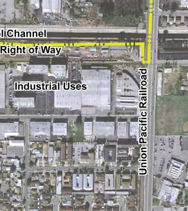
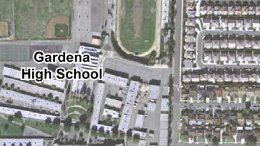
4 source: Impact Sciences, 2006 Figure 2.3b Project Aerial
5 2.5 ENVIRONMENTAL ASSESSMENT The Environmental Impact Report (EIR) serves primarily as a source of environmental information for the City of Gardena as lead agency for the project. The EIR describes the potential impacts that could result from the adoption of the Artesia Corridor Specific Plan. Subsequent development projects within the Artesia Corridor Specific Plan are anticipated. While the EIR has been prepared as a project EIR, as defined by of the CEQA Guidelines, subsequent projects that are within the scope of this EIR may be subject to a more limited environmental review process if that is determined to be necessary by the Director of Community Development of the City of Gardena
6 This page intentionally left blank
CHAPTER 1. Ms. Guajardo s Class - Central Elementary CH 1 1
 INTRODUCTION CHAPTER 1 Ms. Guajardo s Class - Central Elementary CH 1 1 1.1 SETTING South Centre City is a linear corridor south of Downtown Escondido paralleling Centre City Parkway and South Escondido
3.0 PROJECT DESCRIPTION
 3.0 PROJECT DESCRIPTION 3.1 BACKGROUND Under California law (Government Code Section 65300 et seq.), every city and county is required to have a general plan. The general plan is to be comprehensive and
PROJECT DESCRIPTION ENVIRONMENTAL SETTING. Project Site Location FIGURE 1 - REGIONAL LOCATION MAP
 PROJECT DESCRIPTION ENVIRONMENTAL SETTING Project Site Location The proposed project site is located within the City of Camarillo in Ventura County. As shown in Figure 1, the City of Camarillo is located
3. Project Description
 3.1 PROJECT LOCATION The Platinum Triangle (herein after also referred to as the Project Area ) is located at the confluence of the Interstate 5 (I-5 Freeway) and the State Route 57 (SR-57 Freeway), in
2.0 PROJECT DESCRIPTION
 2.0 PROJECT DESCRIPTION The proposed project involves the redevelopment of an approximately 6.3-acre site in the City of Long Beach with a mixed-use village center project. This section describes the project
THEMES, VISION, + PRINCIPLES
 CHAPTER 2: THEMES, VISION, + PRINCIPLES This page intentionally left blank. 20 VISION DRAFT AUGUST 2018 2 2 THEMES, VISION, + GUIDING PRINCIPLES The Key Themes, Vision, and Guiding Principles presented
Venice Pumping Plant Dual Force Main Project Draft EIR
 City of Los Angeles 5.9 LAND USE PLANS 5.9.1 Environmental Setting Venice Pumping Plant Dual Force Main Project Draft EIR The Project lies within the bounds of Los Angeles County and the City of Los Angeles.
Call to Artists Public Art for Los Angeles Metro Stations
 Conceptual Design for Call to Artists Public Art for Los Angeles Metro Stations Artesia Transit Center Union Station/Patsaouras Transit Plaza Los Angeles County Metropolitan Transportation Authority February
III. PROJECT DESCRIPTION
 III. PROJECT DESCRIPTION LOCATION AND BOUNDARIES The City of Manhattan Beach is located in the South Bay region of Los Angeles County, California, approximately 2 miles south of the Los Angeles International
NOTICE OF PREPARATION
 NOTICE OF PREPARATION DATE: April 6, 2017 TO: FROM: Responsible Agencies Trustee Agencies Local and Public Agencies Interested Parties Contact: Brent Cooper, AICP, Community Development Director 4381 Broadway
A. WHAT IS A GENERAL PLAN?
 I. Introduction A. WHAT IS A GENERAL PLAN? A general plan is the planning guideline for the future of a city. It contains goals and policies which regulate urban development, the protection of the natural
Appendix A: Notice of Preparation and Responses
 City of American Canyon Broadway District Specific Plan Draft EIR Appendix A: Notice of Preparation and Responses FirstCarbon Solutions \\10.200.1.5\adec\Publications\Client (PN JN)\3148\31480009\EIR\2
Glenborough at Easton Land Use Master Plan
 Implementation 114 9.0 IMPLEMENTATION 9.1 OVERVIEW This chapter summarizes the administrative procedures necessary to implement the proposed land use plan, infrastructure improvements, development standards,
4. Environmental Setting
 4.1 INTRODUCTION The purpose of this section is to provide, pursuant to provisions of the California Environmental Quality Act (CEQA) and the State CEQA Guidelines, a description of the physical environmental
REPORT TO COUNCIL City of Sacramento
 Honorable Mayor and Members of the City Council REPORT TO COUNCIL City of Sacramento 915 I ' Street, Sacramento, CA 95814-2604 www. CityofSacramento.org Consent April 1, 2010 Title: Initiation of the Establishment
3.0 LAND USE PLAN. 3.1 Regional Location. 3.2 Existing Conditions Existing Uses. Exhibit Regional Location Map
 3.0 LAND USE PLAN 3.1 Regional Location The Anaheim Resort Specific Plan (ARSP) area is located in the City of Anaheim, which is 35 miles southeast of downtown Los Angeles and 7 miles northwest of Santa
5.15 PUBLIC SERVICES Fire Protection and Emergency Services. 5. Environmental Analysis REGULATORY FRAMEWORK.
 5.15 This section of the program EIR evaluates the potential for implementation of the SUP to create a significant impact related to public services in the District, including: fire protection and emergency,
2.1.8 Cultural Resources Regulatory Setting. Affected Environment, Environmental
 REVISED DRAFT ENVIRONMENTAL IMPACT REPORT/ Affected Environment, Environmental 2.1.8 Cultural Resources This section evaluates the potential for historical and archaeological resources within the proposed
No comments related to land use and planning issues were received in response to the Notice of Preparation.
 4.8 LAND USE AND PLANNING This section analyzes the impacts relative to land use and planning that would occur as a result of implementation of the proposed Facilities Master Plan (proposed project). This
4. SPECIFIC PLAN CONCEPTS
 4. SPECIFIC PLAN CONCEPTS 4.1 SPECIFIC PLAN OBJECTIVES The overall purpose of this Specific Plan is to generate momentum and provide comprehensive direction for the improvement of the Artesia Corridor
SECTION 2.0 INTRODUCTION
 SECTION 2.0 INTRODUCTION 2.1 PURPOSE AND SCOPE OF THE EIR Environmental Impact Reports (EIR) are informational documents which wil inform public agency decision-makers and the public generally of the significant
4.8 LAND USE AND PLANNING
 4.8 LAND USE AND PLANNING 4.8.1 INTRODUCTION This section describes existing and planned land uses at the Hayward campus and analyzes the impact of implementation of the proposed Master Plan on land uses
Department of Community Development. Planning and Environmental Review Division Revised Notice of Preparation
 Department of Community Development Michael J. Penrose, Acting Director Divisions Building Permits & Inspection Code Enforcement County Engineering Economic Development & Marketing Planning & Environmental
1INTRODUCTION. Purpose of the Truckee Railyard Master Plan
 1INTRODUCTION Purpose of the Truckee Railyard Master Plan The purpose of the Truckee Railyard Master Plan is to capture and describe the Town s vision for the Railyard Area and to guide its future redevelopment.
5.9 LAND USE Existing Conditions Historic Land Use Trends Existing Land Use Distribution
 5.9 LAND USE This section describes the existing land use pattern and land use planning/regulatory framework in the City of Fontana. It also evaluates potential long-term land use impacts such as physically
AGENDA 07/14/11 PLANNING COMMISSION Meeting
 AGENDA 07/14/11 PLANNING COMMISSION Meeting MEETING DATE: Thursday, July 14, 2011 MEETING TIME: MEETING PLACE: VIDEO: 5:30 p.m. City Council Chambers, City Hall 350 Main Street El Segundo, California 90245-0989
THE PLANNING AREA 2.1 PLANNING AREA LOCATION
 2. The Planning Area Brisbane Baylands Specific Plan 21 2 THE PLANNING AREA 2.1 PLANNING AREA LOCATION The Baylands is located approximately midway between San Francisco s central business district and
3.0 Cumulative Scenario and Methodology. 3.0 Cumulative Scenario and Methodology
 3.0 Cumulative Scenario and Methodology Under the CEQA Guidelines, a cumulative impact consists of an impact which is created as a result of the combination of the project evaluated in the environmental
NOTICE OF PREPARATION ENVIRONMENTAL IMPACT REPORT AND PUBLIC SCOPING MEETING
 City of Alhambra October 10, 2017 Development Services Department 111 South First Street Alhambra, CA 91801 NOTICE OF PREPARATION ENVIRONMENTAL IMPACT REPORT AND PUBLIC SCOPING MEETING CASE NO.: Residential
Community Plan TABLE OF CONTENTS ACTIVITY LOG
 Community Plan TABLE OF CONTENTS ACTIVITY LOG COMMUNITY MAPS COMMUNITY PLAN I. Introduction II. Function of the Community Plan III. Land Use and Programs IV. Coordination Opportunities for Public Agencies
Table L-1 Summary Action Strategy. Action Item Timing Status Responsible Agency
 CHAPTER 4: CIRCULATION ELEMENT ISSUE #1: MAJOR THOROUFARES AND TRANSPORTATION ROUTES A balanced transportation system for Fontana is provided that meets the mobility needs of current and future residents
APPENDIX D: BACKGROUND AND VISION
 APPENDIX D: BACKGROUND AND VISION BACKGROUND A. Specific Plan Location Jordan Downs is located at 9800 Grape Street in Los Angeles, California, 90002. The Jordan Downs Urban Village Specific Plan area
SAN RAFAEL GENERAL PLAN 2040 INTRODUCTION AND OVERVIEW
 SAN RAFAEL GENERAL PLAN 2040 INTRODUCTION AND OVERVIEW Steering Committee Presentation February 14, 2018 Purpose of General Plan Guide land use and development decisions Coordinate transportation, infrastructure,
3.0 Project Description
 3.0 Project Description 3.0 PROJECT DESCRIPTION 3.1 PROJECT LOCATION AND SETTING PROJECT LOCATION The proposed Downtown Lancaster Specific Plan Project (project) is located in the City of Lancaster, California.
WEST OAKLAND SPECIFIC PLAN & DRAFT ENVIRONMENTAL IMPACT REPORT
 WEST OAKLAND SPECIFIC PLAN & DRAFT ENVIRONMENTAL IMPACT REPORT Landmarks Preservation Advisory Board Public Hearing February 10, 2014 1 Specific Plan Overview Plan Area is generally bounded by I-580 to
SUBJECT: PREDEVELOPMENT PLAN REVIEW OF PROJECT LOCATED AT 2632 EAST WASHINGTON BOULEVARD ('ST. LUKE MEDICAL CENTER')
") TO: FROM: Honorable Mayor and City Council Planning & Community Development Department SUBJECT: PREDEVELOPMENT PLAN REVIEW OF PROJECT LOCATED AT 2632 EAST WASHINGTON BOULEVARD ('ST. LUKE MEDICAL CENTER')
TO: FROM: Honorable Mayor and City Council Planning & Community Development Department SUBJECT: PREDEVELOPMENT PLAN REVIEW OF PROJECT LOCATED AT 2632 EAST WASHINGTON BOULEVARD ('ST. LUKE MEDICAL CENTER')
4.1 LAND USE AND PLANNING EXISTING CONDITIONS REGULATORY BACKGROUND LAND USES IN THE PLAN AREA SURROUNDING LAND USES
 4.1 LAND USE AND PLANNING This section includes a description of the existing land use plans that apply to the Plan area and a description of existing land uses in the vicinity. It also includes an analysis
ENVIRONMENTAL SETTING
 II. ENVIRONMENTAL SETTING EXISTING CONDITIONS The 208.87-acre Project site is located in the western portion of the City (refer to Figures II-1 and II-2). The Project site comprises Assessor s Parcel Number
2 Project Description
 Project Description 2 Project Description The proposed project would involve the demolition of the existing church and the construction of 40 twostory single family residences. The residential lots would
ENVIRONMENTAL INITIAL STUDY BERKELEY CITYWIDE POOLS MASTER PLAN
 ENVIRONMENTAL INITIAL STUDY FOR THE BERKELEY CITYWIDE POOLS MASTER PLAN CITY OF BERKELEY PARKS RECREATION AND WATERFRONT DEPARTMENT SEPTEMBER 1, 2009 ENVIRONMENTAL INITIAL STUDY BERKELEY CITYWIDE POOLS
CENTRAL ESTUARY PLAN AVISION FOR OAKLAND S WATERFRONT
 Central Estuary Plan A VISION FOR OAKLAND S WATERFRONT Specific Plan and Environmental Assessment Presentation to the Parks and Recreation Advisory Commission December 9, 2009 This Afternoon s Presentation
A P P E N D I X B - O P P O R T U N I T Y S I T E S
 A P P E N D I X B - O P P O R T U N I T Y S I T E S OPPORTUNITY SITES As listed in the Land Use Element, the City has identified 15 Opportunity Sites expected to be the focus of change and revitalization
IV. ENVIRONMENTAL IMPACT ANALYSIS
 IV. ENVIRONMENTAL IMPACT ANALYSIS IV. ENVIRONMENTAL IMPACT ANALYSIS A. LAND USE AND PLANNING 1. INTRODUCTION This section addresses the impacts of the proposed Project in relationship to applicable land
II. PROJECT DESCRIPTION
 II. PROJECT DESCRIPTION A. PROJECT APPLICANT The project applicant is the J.H. Snyder Company located at 5757 Wilshire Boulevard, Penthouse 20, in Los Angeles, CA 90036. B. PROJECT LOCATION The project
LOS ANGELES COUNTY METROPOLITAN TRANSPORTATION AUTHORITY (LACMTA)
") CE OF PREPARAT LOS ANGELES COUNTY METROPOLITAN TRANSPORTATION AUTHORITY (LACMTA) NOTICE OF PREPARATION OF AN ENVIRONMENTAL IMPACT STATEMENT (E1S)lENVIRONMENTAL IMPACT REPORT (EIR) TO: AGENCIES, ORGANIZATIONS
CE OF PREPARAT LOS ANGELES COUNTY METROPOLITAN TRANSPORTATION AUTHORITY (LACMTA) NOTICE OF PREPARATION OF AN ENVIRONMENTAL IMPACT STATEMENT (E1S)lENVIRONMENTAL IMPACT REPORT (EIR) TO: AGENCIES, ORGANIZATIONS
Section Regulatory Framework/Methodology. Land Use and Development
 Section 4.2 Land Use and Development This section summarizes the existing land uses and developments in the project area, and the potential impacts of the proposed alternatives on these resources. Information
City Of Sparks Planning Commission Item
 Page 1 of 12 City Of Sparks Planning Commission Item Meeting Date: May17, 2012 Subject: PCN12009, Public Hearing, Consideration and possible action on a Master Plan Amendment and Rezoning request to change
Authority of the General Plan
 Authority of the General Plan This La Habra Heights General Plan will serve as the blueprint for future planning and development in the City. This General Plan describes the City s vision for the future
NOTICE OF PREPARATION
 NOTICE OF PREPARATION To: All Interested Parties Subject: Notice of Preparation of an Environmental Impact Report From: City of Petaluma Address: 11 English Street, Petaluma, CA 94952-2610 Contact: Heather
Land Use Element. policy areas are discussed in this Element:
 Land Use Element Land Use is often considered the heart of the General Plan. The statement of future land uses describes how the City believes it should develop in the future where housing, shopping, open
II. PROJECT DESCRIPTION
 II. PROJECT DESCRIPTION II. PROJECT DESCRIPTION A. LOCATION AND BOUNDARIES The proposed Project consists of two components; the development of a mixed use project consisting of residential and retail uses
4. ENVIRONMENTAL IMPACT ANALYSIS 7. LAND USE AND PLANNING
 4. ENVIRONMENTAL IMPACT ANALYSIS 7. LAND USE AND PLANNING 4.7.1 INTRODUCTION The following analysis discusses the consistency of the Proposed Project with the corresponding land use and zoning designations
City Center Neighborhood Plan
 [1] City Center Neighborhood Plan As adopted by Ordinance No. 2014-09-049 and amended by Ordinance Nos. Formerly CBD Neighborhood as adopted by Ordinance No. 8868 and amended by Ordinance Nos. 8946, 9693,
Chapter 12. Land Use
 \ I Chapter 12 Chapter 12. INTRODUCTION This chapter describes existing and planned land uses in the JOS service area and identifies impacts of the JOS 2010 Master Facilities Plan and alternatives. Existing
DRAFT Concept Alternatives
 O c t o b e r 2016 DRAFT Concept Alternatives W a l n u t G e n e r a l P l a n U p d a t e a n d W e s t Va l l e y S p e c i f i c P l a n Contents WHAT IS THE GENERAL PLAN..........................................
~P'~'~; SAN FRANCISCO
 ~o counr~, ~P'~'~; SAN FRANCISCO ~'.~ PLANNING DEPARTMENT a 2 757 O~~~S 0 Case No.: Project Address: Zoning: Certificate of Determination COMMUNITY PLAN EVALUATION UMU (Urban Mixed Use) District 58-X Height
4.1 AESTHETICS AND VISUAL QUALITY
 SCOPE AND METHODOLOGY 4.1 AESTHETICS AND VISUAL QUALITY This section evaluates the potential impacts to aesthetics and visual quality. Aesthetics refers to visual resources and the quality of what can
2.0 PROJECT DESCRIPTION
 2.0 PROJECT DESCRIPTION 2.1 PROJECT LOCATION The Project Site is located in the City of Santa Clarita, California, about 35 miles north of Downtown Los Angeles. The Project Site is more specifically located
Corridor Vision. 1Pursue Minnehaha-Hiawatha Community Works Project. Mission of Hennepin County Community Works Program
 1Pursue Minnehaha-Hiawatha Community Works Project Minnehaha-Hiawatha Community Works is a project within the Hennepin Community Works (HCW) program. The mission of the HCW program is to enhance how the
Gold Line Bus Rapid Transit Transit Oriented Development (BRTOD) Helmo Station Area Plan
 Helmo Station Area Plan") Appendix F Gold Line Bus Rapid Transit Transit Oriented Development (BRTOD) Helmo Station Area Plan Introduction and Purpose of the Plan The Gold Line Bus Rapid Transit facility is an eleven-mile dedicated
Appendix F Gold Line Bus Rapid Transit Transit Oriented Development (BRTOD) Helmo Station Area Plan Introduction and Purpose of the Plan The Gold Line Bus Rapid Transit facility is an eleven-mile dedicated
III. GENERAL DESCRIPTION OF ENVIRONMENTAL SETTING
 III. GENERAL DESCRIPTION OF ENVIRONMENTAL SETTING Section 15125 of the California Environmental Quality Act (CEQA) Guidelines requires that an EIR include a description of the existing environment. This
3.10 LAND USE SETTING PROJECT SITE EXISTING LAND USE DESIGNATIONS AND ZONING. General Plan Land Use Designations.
 This section of the Draft EIR addresses the existing land uses on and adjacent to the project site and discusses the potential impacts of the proposed project on existing land uses. Key issues addressed
ECONOMIC DEVELOPMENT DISTRICT MASTER PLAN
 ECONOMIC DEVELOPMENT DISTRICT MASTER PLAN E Orange Ave Legend for the CIT Y OF MOUNT DORA/LAKE COUNT Y County Boundary Wekiva Corridor (Proposed Alignment) Public Land and Parks Park Public CityLimits
Community Design Plan
 Gardena General Plan 2006 Authority While the is not a required element of a General Plan, it is included because improving the community appearance and image is paramount to the overall quality of life
CITY OF LOMPOC PLANNING COMMISSION STAFF REPORT
 CITY OF LOMPOC PLANNING COMMISSION STAFF REPORT DATE: January 11, 2017 TO: FROM: Members of the Planning Commission Sara Farrell, Assistant Planner RE: Development Plan Review DR 16-05 The Laundry Room
Parts Standardization & Management Committee (PSMC)
") Parts Standardization & Management Committee (PSMC) 1-3 Nov 2016 Getting to Honeywell-Torrance, CA: See Directions from LAX on Attached Map Lodging Nearby: See Hotels on Map (Ask for Honeywell rate) Virtual
Parts Standardization & Management Committee (PSMC) 1-3 Nov 2016 Getting to Honeywell-Torrance, CA: See Directions from LAX on Attached Map Lodging Nearby: See Hotels on Map (Ask for Honeywell rate) Virtual
Land Use element LAND USE POLICY AREAS ESTATE AND RURAL RESIDENTIAL AREAS/RURAL SHELDON AREA OLD TOWN ELK GROVE
 Land Use element Land Use is often considered the heart of the General Plan. The statement of future land uses describes how the City believes it should develop in the future where housing, shopping, open
5.10 LAND USE AND PLANNING
 5.10 This section of the program EIR evaluates the potential for implementation of the SUP to impact land uses in the District. This section discusses plans and policies from several jurisdictional agencies
March 29, Angels Landing Project Angels Landing Partners, LLC
 March 29, 2019 ENVIRONMENTAL CASE NO.: ENV-2018-3273-EIR PROJECT NAME: PROJECT APPLICANT: Angels Landing Project Angels Landing Partners, LLC PROJECT ADDRESS: 361 S. Hill Street (332-358 S. Olive Street,
City of Long Beach. creating vibrant and exciting places
 City of Long Beach creating vibrant and exciting places Land Use Element Urban Design Element Overview of the two draft General Plan elements Discuss areas of change Economic goals of the plans Case study
City of Farmington. Downtown Plan. Amendment to the 1998 Master Plan Adopted October 11, 2004
 City of Farmington Amendment to the 1998 Master Plan Adopted October 11, 2004 Introduction Planning Background 1 Scope and Components of the Plan Amendment 2 Concept Introduction 3 Plan Concepts 3 Conceptual
17.11 Establishment of Land Use Districts
 17.11 Establishment of Land Use Districts 17.11.010 Purpose. To promote the health, safety, and general welfare of City residents and those who come to South Salt Lake to work, exchange commerce and recreate.
Planning Commission Staff Report Agenda Item No. 4 March 7, 2019
 DEPARTMENT OF PUBLIC WORKS AND PLANNING STEEN E. WHITE, DIRECTOR Planning Commission Staff Report Agenda Item No. 4 March 7, 2019 SUBJECT: General Plan Conformity Application Clovis Unified School District
SAN FRANCISCO. x ~ OT`s 0~5` PLANNING DEPARTMENT. Certificate of Determination COMMUNITY PLAN EVALUATION PROJECT DESCRIPTION CEQA DETERMNATION
 y;~~~ counr~on u "'s' 9z x ~ OT`s 0~5` SAN FRANCISCO PLANNING DEPARTMENT COMMUNITY PLAN EVALUATION Case No.: Project Address: Zoning: RTO-M (Residential Transit Oriented-Mission) Use District Calle 24
March 30, Keyes Van Nuys Honda Dealership Keyes Motor, Inc.
 March 30, 08 ENVIRONMENTAL CASE NO.: ENV-07-77-EIR PROJECT NAME: PROJECT APPLICANT: Keyes Van Nuys Honda Dealership Keyes Motor, Inc. PROJECT ADDRESS: 600, 6007, 605, 6053, and 6059 N. Van Nuys Boulevard;
City of Gardena GENERAL PLAN 2020 DRAFT Technical Background Report
 City of Gardena GENERAL PLAN 2020 DRAFT Prepared for City of Gardena Prepared by USC Center for Economic Development School of Policy, Planning, and Development University of Southern California City of
December 18, January 14, 2019, 5:00 P.M. 7:00 P.M. See below for additional information.
 December 8, 208 ENVIRONMENTAL CASE NO.: ENV-208-6667-EIR PROJECT NAME: Reese Davidson Community Project PROJECT APPLICANT: Venice Community Housing Corp./ Hollywood Community Housing Corp. PROJECT ADDRESS:
COUNTY OF RIVERSIDE PLANNING DEPARTMENT STAFF REPORT
 Agenda Item No.: 5.4 Area Map: Jurupa Zoning District: Prado-Mira Loma Supervisorial District: Second Project Planner: Christian Hinojosa Planning Commission: February 3, 2010 Conditional Use Permit No.
SECTION IV: DEVELOPMENT CONCEPT
 80 SECTION IV: DEVELOPMENT CONCEPT Section IV: DEVELOPMENT CONEPT This section provides an overall understanding and rationale for what is envisioned in The Preserve, the intended quality and character
RESOLUTION NO. R Refining the route, profile and stations for the Downtown Redmond Link Extension
 RESOLUTION NO. R2018-32 Refining the route, profile and stations for the Downtown Redmond Link Extension MEETING: DATE: TYPE OF ACTION: STAFF CONTACT: Capital Committee Board PROPOSED ACTION 09/13/2018
A. OVERVIEW OF ENVIRONMENTAL SETTING
 IV. A. OVERVIEW OF The proposed site is comprised of three parcels totaling approximately 4.24 acres, situated southwesterly of the intersection of Weyburn and Tiverton Avenues. Parcel A is 2.72 acres
Report to City Council
 Attachment 4 BUDGET OFFICER CITY ATTORNEY APPROVALS CITY MANAGER Report to City Council TO: FROM: Mayor and City Council John C. Terell, Community and Economic Development Director AGENDA DATE: June 24,
Notice of Preparation
 Notice of Preparation OF ENVIRONMENTAL IMPACT REPORT AND PUBLIC SCOPING MEETING August 23, 2017 CASE NO.: ENV-2017-506-EIR PROJECT NAME: 8th, Hope, and Grand PROJECT APPLICANT: MFA 8th Grand and Hope LLC
Chelsea Creek Municipal Harbor Plan
 Chelsea Creek Municipal Harbor Plan Public Meeting #1 June 11th, 2018 1 Presentation outline I. Introduction: Why are we doing this plan? II. Evolution of Chelsea Creek III. State of Chelsea Creek IV.
CITY OF VACAVILLE PLANNING COMMISSION Item No. 8.A STAFF REPORT July 18, 2016 STAFF CONTACT: Amy Feagans, Contract Planner (707)
") CITY OF VACAVILLE PLANNING COMMISSION Item No. 8.A STAFF REPORT July 18, 2016 STAFF CONTACT: Amy Feagans, Contract Planner (707) 449-5140 TITLE: THE FARM AT ALAMO CREEK ENVIRONMENTAL IMPACT REPORT (EIR)
CITY OF VACAVILLE PLANNING COMMISSION Item No. 8.A STAFF REPORT July 18, 2016 STAFF CONTACT: Amy Feagans, Contract Planner (707) 449-5140 TITLE: THE FARM AT ALAMO CREEK ENVIRONMENTAL IMPACT REPORT (EIR)
Prepared by: Casey Kempenaar, Senior Planner
 CITY OF CITRUS HEIGHTS PLANNING DIVISION STAFF REPORT PLANNING COMMISSION MEETING September 13, 2017 Prepared by: Casey Kempenaar, Senior Planner REQUEST The applicant requests a Design Review Permit Modification
CITY OF COLWICH COMPREHENSIVE PLAN LAND USE LAND USE 1
 LAND USE LAND USE 1 WHAT YOU WILL FIND IN THIS CHAPTER: Discussion of today s conditions and tomorrow s projections Discussion of challenges and opportunities Discussion of the environmental quality goals,
Planning Commission Report
 Planning Commission Report To: From: Subject: Planning Commission Meeting: January 6, 2016 Agenda Item: 8-B Planning Commission David Martin, Planning & Community Development Director Introduction to the
CITY OF ALHAMBRA DEVELOPMENT SERVICES DEPARTMENT 111 S. First Street. Alhambra, CA (626) FAX (626)
 FAX (626)") CITY OF ALHAMBRA DEVELOPMENT SERVICES DEPARTMENT 111 S. First Street. Alhambra, CA 91801 (626) 570-5030 - FAX (626) 458-4201 NOTICE OF PREPARATION TO: SUBJECT: Agencies, Organizations and Interested Parties
CITY OF ALHAMBRA DEVELOPMENT SERVICES DEPARTMENT 111 S. First Street. Alhambra, CA 91801 (626) 570-5030 - FAX (626) 458-4201 NOTICE OF PREPARATION TO: SUBJECT: Agencies, Organizations and Interested Parties
CITY OFLOS ANGELES CALIFORNIA
 BOARD OF PUBLIC WORKS MEMBERS KEVIN JAMES PRESIDENT HEATHER MARIE REPENNING VICE PRESIDENT MICHAEL R. DAVIS PRESIDENT PRO TEMPORE JOEL F. JACINTO COMMISSIONER VACANT COMMISSIONER FERNANDO CAMPOS EXECUTIVE
ARLINGTON COUNTY, VIRGINIA
 ARLINGTON COUNTY, VIRGINIA County Board Agenda Item Meeting October 15, 2005 DATE: September 28, 2005 SUBJECT: Request to Advertise the adoption of the 2005 Clarendon Sector Plan C. M. RECOMMENDATION:
CHAPTER 2 SUMMARY 1. PROJECT SUMMARY DATA
 CHAPTER 2 SUMMARY This is an Initial Study format used to determine, pursuant to CEQA Guidelines Section 15177, whether a project 1) is within the scope of a Master EIR (MEIR), 2) may result in additional
Appendix L SH 360 OVERLAY DISTRICT. LAST UPDATE: December 10, 2013 CASE NUMBER: TA ORDINANCE NO
 Appendix L SH 360 OVERLAY DISTRICT LAST UPDATE: December 10, 2013 CASE NUMBER: TA131201 ORDINANCE NO. 9655 2013 Unified Development Code Grand Prairie, Texas Planning Department APPENDIX L: SH 360 OVERLAY
WEST OAKLAND SPECIFIC PLAN PROJECT DESCRIPTION
 WEST OAKLAND SPECIFIC PLAN PROJECT DESCRIPTION INTRODUCTION The West Oakland Specific Plan will guide future development in West Oakland. The purpose of the proposed West Oakland Specific Plan is to provide
FINAL WEST OAKLAND SPECIFIC PLAN & FINAL ENVIRONMENTAL IMPACT REPORT
 1 FINAL WEST OAKLAND SPECIFIC PLAN & FINAL ENVIRONMENTAL IMPACT REPORT Landmarks Preservation Advisory Board Public Hearing June 9, 2014 2 Purpose of LPAB public hearing Provide cultural-resource related
EXHIBIT A. Tax Increment Reinvestment Zone No. 1 (Town Center) First Amended Project Plan 1
 First Amended Project Plan 1") EXHIBIT A Tax Increment Reinvestment Zone No. 1 (Town Center) First Amended Project Plan 1 1 As amended by Resolution No. 2008-02-001(TR1R) of the Tax Increment Reinvestment Zone No.1, and approved to
EXHIBIT A Tax Increment Reinvestment Zone No. 1 (Town Center) First Amended Project Plan 1 1 As amended by Resolution No. 2008-02-001(TR1R) of the Tax Increment Reinvestment Zone No.1, and approved to
C. Westerly Creek Village & The Montview Corridor
 C. Westerly Creek Village & The VISION Community Vision When the goals of the city are achieved Westerly Creek Village, a distinctive community defined by Montview Boulevard and Westerly Creek, is a strong
Micco Park Village Development
 FOR SALE Call For Pricing Micco Park Village Development Proposed Project Property Details Micco Park Village Development PRICE Call For Pricing A monumental development opportunity of a lifetime! The
Visioning Statement and Guiding Principles
 Visioning Statement and Guiding Principles Planning for the Future The General Plan The General Plan represents Woodland's shared vision of the future and defines a path to lead the community toward its
Historic Resources. San Mateo has a Historic Building Survey that identified roughly 200 historically significant
 Historic Resources City of San Mateo Planning Division Community Development Department 330 West 20 th Avenue www.cityofsanmateo.org San Mateo, CA 94403 planning @cityofsanmateo.org Updated: March 20,