City of Peterborough Draft Official Plan 2016 Part 1 (Sections A to C) Vision and Strategic Policies
|
|
|
- Molly Robertson
- 5 years ago
- Views:
Transcription
1 City of Peterborough Draft Official Plan 2016 Part 1 (Sections A to C) Vision and Strategic Policies Includes Figure 2 Commercial Structure and Schedule A-1 City Structure
2 Table of Contents A. INTRODUCTION... A-1 1. THE CITY OF PETERBOROUGH OFFICIAL PLAN... A Purpose of the Official Plan... A Plan Organization and Interpretation... A Context... A Time Frame and Effect of the Plan... A Contents... A-6 B. VISION AND GUIDING PRINCIPLES... B-1 2. ESTABLISHING A VISION... B Vision Statement... B Guiding Principles... B-1 A Complete Community... B-1 A Sustainable Environment... B-2 A Unique and Vibrant Sense of Place... B-2 A Linked Community... B-3 A Strong and Diverse Economy... B-3 C. STRATEGIC POLICIES TO IMPLEMENT THE VISION... C-1 3. IMPLEMENTING THE VISION... C Growth Management... C-1 Built Boundary... C-2 Urban Growth Centre... C-3 Designated Greenfield Areas... C-3 Intensification Corridors and Major Transportation Stations... C A Complete Community... C A Sustainable Environment... C-7 Natural Heritage Features and Areas... C-9 Water... C-10 Natural Hazards... C-11 Energy Conservation and Generation, Air Quality and Climate Change... C-11 Access to Local Food... C-13 Urban Forest... C A Unique and Vibrant Sense of Place... C-14 Cultural Heritage Resources... C-15 Heritage Impact Assessment... C-16 Last Update January 21, 2016
3 Heritage Conservation District(s)... C-16 Archaeological Resources... C-16 Urban Design... C-16 Public Art... C A Linked Community... C A Strong and Diverse Economy... C-19 Infrastructure and Public Service Facilities... C-21 Employment Areas... C-22 Commercial Strategy and Structure... C-23 Role and Components... C-25 The Central Area... C-26 Shopping Nodes... C-27 Special Policy Areas... C-28 Proposed Amendments and Monitoring... C-28 Last Update January 21, 2016
4 The following sections are not included in this draft document: D. NATURAL HERITAGE AREAS AND POLICIES 4.7 Natural Areas E. LAND USE DESIGNATIONS AND POLICIES 5. PERMITTED LAND USE 5.1 Policies for all areas 5.2 Commercial 5.3 Industrial 5.4 Major Institutions Re-Use of Sites 5.5 Residential (Low Medium High & Special Policies) 5.6 Major Open Space 5.7 Utilities 5.8 Controlled or Interim Uses Agriculture Rural Pits and Quarries Adult Entertainment F. SPECIAL AREA POLICIES Jackson Creek Flood Plain G. TRANSPORTATION POLICIES General Policies Transportation Master Plan Road Network Planned Rights of Way Public Transit Parking Active Transportation Bikeways Pedestrian System Railways Navigable Waterways H. SERVICING AND UTILITIES General Policies Sewage and Water Treatment Storm Water Management Utilities Transmission Corridors Extension of Services Outside City Limits Financing of Infrastructure Last Update January 21, 2016
5 The following sections are not included in this draft document: I. IMPLEMENTATION AND INTERPRETATION 8.1 Official Plan Amendments 8.2 Zoning Holding By-laws (including special provisions for Commercial Areas) Temporary Use By-laws Interim use By-laws Bonusing By-laws 8.3 Alteration of Grades (s. 3.10) 8.4 Committee of Adjustment 8.5 Legal Non-Conforming Uses 8.6 Site Plan Control 8.7 Land Acquisition 8.8 Parkland Dedication 8.9 Plans of Subdivision 8.10 Consents 8.11 Community Improvement Plans and Areas 8.12 Maintenance and Occupancy 8.13 Demolition Control 8.14 Pre-consultation and Determination of a Complete Application 8.15 Monitoring (including monitoring of commercial development move policies here) 8.16 Alternative Notice Procedures J. INTERPRETATION OF THE OFFICIAL PLAN (including Secondary Plans, in case of conflict) 9.1 General 9.2 Numerical Requirements (i.e. minor deviation permitted without OPA) 9.3 Definitions K. SECONDARY PLANS Residential AA Downie West Secondary Plan BB Auburn North CC - DD - Employment and Mixed Use RR Landsdowne West Secondary Plan (Harper Park/Peterborough Business Park) SS Last Update January 21, 2016
6 Figures and Schedules Figures Figure 1: Regional Context of the City Figure 2: Peterborough s Commercial Structure Figure 3: Key Map for Secondary Planning Areas Schedules Only Schedule A-1 City Structure is included in this draft document Structural Elements A-1 City Structure Natural Heritage System (including waterways & Floodplain) Land Use Schedules Land Use Plan Commercial Areas Central Area Land Use Industrial/Employment Land Use Residential Density Special Policy Areas Jackson Creek (downtown) Floodplain Community Improvement Area(s) Infrastructure Major Transportation Plan Active Transportation Bicycle Routes, Pedestrian Routes, and Trails Watersheds Transmission Corridors Secondary Plan Schedules AA: Secondary Plan BB: Secondary Plan CC: Secondary Plan Last Update January 21, 2016
7 Draft Official Plan 2016 Section A Introduction
8 A. INTRODUCTION 1. THE CITY OF PETERBOROUGH OFFICIAL PLAN Situated on the Trent-Severn Waterway, Peterborough is a complete community that provides a broad range of housing, as well as employment opportunities, recreation and cultural amenities and regional services. The City of Peterborough is a single-tier municipality that is the focus of a broader region for health, education, manufacturing, commerce, entertainment and many services. In recognition of this relationship, the City will liaise with the County and surrounding municipalities in the development of an effective land use pattern. This Official Plan will guide the City s development to Purpose of the Official Plan The Planning Act of Ontario requires that an Official Plan be prepared for each municipality and that the Plan contain goals, objectives and policies established primarily to manage and direct physical change and the effects on the social, economic and natural environment of the municipality. The Official Plan of the City of Peterborough: 1. establishes a vision, guiding principles, strategic direction, goals, objectives and policies to manage and direct land use, important resources and future development within the City in a manner that will enhance the economic, social, cultural, and natural environments of the municipality to the year 2036; 2. promotes a complete, healthy and resilient community with a strong economy, a sustainable land use pattern, protected natural and cultural heritage resources, and unique and vibrant spaces; 3. provides sufficient land for projected needs and co-ordinates land use with infrastructure requirements to create a compact and complete community with enhanced connectivity; 4. establishes a policy context for decision-making with respect to land use matters and development processes, in co-ordination with broader regional plans; 5. complies with Provincial Plans (including the Growth Plan for the Greater Golden Horseshoe) and is consistent with Provincial Policy Statement (PPS) 2014, which expresses matters of Provincial interest. 1.2 Plan Organization and Interpretation This Plan is to be read as a whole. The Plan comprises comprehensive and integrated policy, maps and schedules that provide Council s framework for making decisions with respect to physical change in the City and its associated impacts on the welfare of the social, economic, cultural and natural environment. A-1 Last Update January 21, 2016
9 1.2.2 The Official Plan is referred to as the Plan or this Plan. Council refers to the Council of the Corporation of the City of Peterborough. Planning Committee refers to the Planning Committee of the Council of the City of Peterborough. The City refers to activities of the Corporation, as determined by Council s approval of this Plan Sections through and the accompanying Tables, Maps and Schedules constitute the City of Peterborough Official Plan. Words that are italicized are defined in the Glossary or refer to legislation or studies. Words used in the singular shall include the plural, and words used in the plural shall include the singular Section A, INTRODUCTION, describes the Plan s purpose, structure, context and duration Section B, GOALS OBJECTIVES and GUIDING PRINCIPLES, sets out the City s basis for future development. The principles have been developed from the goals and objectives of broad-based community consultation, various housing, transportation, environmental, cultural and commercial studies conducted by the City Section C, STRATEGIC POLICIES TO IMPLEMENT THE VISION, contains broad strategies for directing growth and development within the City in a sustainable manner. It provides: policies to manage growth and guide development decisions that includes population and employment forecasts to 2036, intensification targets for different areas of the City, and provisions to continue the development of Peterborough as a complete community; a commercial structure of nodes and their planned function for the City; a natural heritage system; cultural heritage and urban design strategies to enhance Peterborough s unique sense of place; and the protection of Employment lands and optimization of infrastructure to support and strengthen the local and regional economy Section D, Natural Areas and Policies sets out policies to describe the importance of natural areas and provide for the protection of these areas for future generations Section E, LAND USE DESIGNATIONS and POLICIES, establishes designations for specific land use types within the Plan, as summarized below: A-2 Last Update January 21, 2016
10 Schedule 1: Land Use Designations Category Commercial Employment Designation Central Area Major Shopping Centre Special Purpose Retail Neighbourhood Centres Service Commercial General Industrial Prestige Industrial Service Industrial Major Institution Residential Natural Heritage & Major Open Space Utilities Interim or Controlled Uses Low Density Medium Density High Density Major Open Space Major Infrastructure Electricity Generation Facilities Transmission and Distribution Systems Public Service Facilities Agriculture Urban Fringe/Rural Pits and Quarries Adult Entertainment Section F, SPECIAL POLICY AREAS establishes policies for Heritage Areas, Special Study Areas and Section G, TRANSPORTATION sets out policies to direct the provision of transportation, within the City Section H, SERVICING AND UTILITIES sets out policies to direct the provisions of municipal water and sewer services, stormwater management facilities, utilities, energy generation and transmission and private water or wastewater services Section I, IMPLEMENTATION AND INTERPRETATION describes implementation tools and processes that will be used to implement policies of the Plan. Interpretation policies and definitions are included as means of implementing the Plan. A-3 Last Update January 21, 2016
11 Part (Section ), SECONDARY PLANS includes additional policies to guide major development or redevelopment within specific geographic areas of the City. Secondary Plans are based on more focused study of such areas. Secondary Plans generally do not conflict with the intent of policies in the Plan and are intended to provide greater policy depth for specific areas or issues where required. 1.3 Context Incorporated in 1850, the City of Peterborough is an economic focal point for the surrounding region. Its early development capitalized on available hydro electric power which fostered industrial development. The City has retained this industrial legacy with such companies as General Electric, Pepsico, Minute Maid, Ventra Plastics, Siemens and Rolls Royce established here. The City is known as the Gateway to the Kawarthas in recognition of its key location on the Trent-Severn waterway, which links Lake Ontario to Georgian Bay through the Kawartha Lake system. Peterborough s historic downtown opens to Little Lake, providing a scenic waterfront and a marina that allows boaters easy access to the core. Tourists are attracted to the Peterborough Lift Lock, the Canadian Canoe Museum, and to numerous cultural venues, festivals and sporting events in the City. Peterborough is home to a number of large institutions that serve a much broader area, including Trent University, Fleming College and the Peterborough Regional Health Centre. The Peterborough Airport, located outside of City boundaries, supports business activities both within the City and in nearby municipalities In accordance with Ontario Regulation 416/05 made under the Places to Grow Act, 2005, S.O. 2005, c. 13, the City of Peterborough is included in the Greater Golden Horseshoe growth plan area and is subject to the policies of the Growth Plan for the Greater Golden Horseshoe, 2006, as amended. The Growth Plan identifies Downtown Peterborough as an Urban Growth Centre that is to be a focus for investment in region-wide facilities and services The City of Peterborough (as illustrated on Figure 1), is the urban hub and focus of the northeast portion of the Greater Golden Horseshoe. The City has historically been subject to less growth pressure than municipalities closer to Toronto and has an older average demographic and smaller average household size than many communities. Based on prevailing demographic trends, it is expected that the City s population growth will be driven by immigration, including the migration of rural residents to urban centres, as well as migration of new citizens. 1 Suggested substitution for s of current OP intent to liaise with neighbouring municipalities is included in former A-4 Last Update January 21, 2016

12 1.3.4 In accordance with Schedule 3 of the Growth Plan for the Greater Golden Horseshoe, Peterborough is forecast to grow from a population of approximately 82,400 people in 2011, to 109,000 people by Employment within the City is expected to increase from approximately 37,000 jobs in 2011 to 54,000 jobs in Figure 1: Regional Context of the City 1.4 Time Frame and Effect of the Plan This Official Plan has been prepared as of 2016, and provides for a planning period to 2036, based on projections of the Growth Plan for the Greater Golden Horseshoe, 2006, as amended It is the policy of this Plan that a general review of the Plan shall be done at intervals of not longer than five years, to be coordinated with revisions to the Growth Plan for the Greater Golden Horseshoe, No by-law may be passed and no public work may be undertaken by the City which does not conform with this Plan as approved. The capital works program and capital works budget are tools to implement the land use and designations of the Plan. (Section 24 of Planning Act) A-5 Last Update January 21, 2016
13 1.5 Contents 2 The Official Plan of the City of Peterborough comprises this text being Sections - inclusive and: Schedule City Structure; Schedule Commercial Structure Schedule Land Use Plan; Schedule Major Transportation Plan; Schedule Flood Plain; Schedule Development Areas; Schedule Residential Density Plan; Schedule Secondary Land Use Plan Reference Map; Schedule Part of Jackson Creek Secondary Plan; Schedule Community Improvement Areas; Schedule Commercial Area; Schedule Central Area; Schedule Areas Designated For Adult Entertainment Parlours; Figures 1: Regional Context of the City, & are included for context and ease of interpretation of this Plan but are not intended as operative parts of The Plan. Schedule L Downey West Secondary Plan Land Use Plan; Schedule M(a) Lansdowne West Secondary Plan: Harper Park/Peterborough Business Park; Schedule N Auburn North Secondary Plan; Schedule O Industrial Land Use and Table 1 Residential Development by Secondary Land Use Plan Areas. 3 2 Re-working of section current section 1.2 (modified) A-6 Last Update January 21, 2016
14 Draft Official Plan 2016 Section B Vision and Guiding Principles
15 B. VISION AND GUIDING PRINCIPLES 2. ESTABLISHING A VISION Many shared visions are synthesized into the themes of this Section. During the preparation and review of the Official Plan, members of the public were involved in a range of stakeholder meetings. Their views together with strategic planning documents that have been prepared by departments within the City, as well as Provincial policies as expressed in the 2014 Provincial Policy Statement and the Growth Plan for the Greater Golden Horseshoe, 2006 have assisted in shaping the goals, objectives and guiding principles of this document. 2.1 Vision Statement Peterborough will continue to develop as a complete, linked city that strives to provide for a decent home for everyone, fosters a sustainable environment, values its natural and cultural heritage, supports a strong and diverse economy and promotes a unique, vibrant sense of place for its residents and visitors. 2.2 Guiding Principles A Complete Community A complete community is one that meets people s needs for daily living throughout their lifetime by providing convenient access to a mix of jobs, services, housing, community infrastructure, open space, and transportation opportunities. Peterborough will continue to grow as a complete community by: providing for a balanced mix of land uses including housing, employment, commercial, community services, necessary infrastructure, parks and significant natural heritage features; undertaking growth management in accordance with Provincial policies and Plans; planning to achieve higher density targets in new greenfield areas and in the Urban Growth Centre that forms a part of the City s Central Area; encouraging increased intensification in built up areas where infrastructure is available and active modes of transportation can be supported; supporting a vibrant, multi-functional Central Area as the civic, cultural, entertainment and economic heart of the City; fostering an inclusive community with a range of housing, accessible transportation modes, amenities and community services for all residents; and providing for balanced commercial development in a hierarchy and system of nodes. B-1 Last Update January 21, 2016
16 A Sustainable Environment A sustainable environment is one that can meet the needs of the present without compromising the ability of future generations to meet their own needs. Peterborough will ensure a more sustainable environment over the long term by: protecting and enhancing natural heritage systems, functions and resources using a watershed approach; encouraging green buildings, increased weather protection, and sustainable development practices that consider the effects of climate change; protecting water quality and sensitive surface water features; fostering the conservation of energy and the use of renewable energy systems and alternative energy systems; promoting local food sources; protecting and enhancing the City s urban forest; and, restricting development in areas that contain hazards to human health or safety. A Unique and Vibrant Sense of Place Communities have social and physical characteristics that make them special and unique and foster a sense of attachment and belonging for residents and visitors. Peterborough is home to a vibrant arts, culture, and heritage community that includes a wide variety of museums; a vibrant theatre scene; hundreds of cultural workers, producers, and organizations; a busy festival calendar; and a well-preserved built heritage. Additionally, Peterborough is set in the Kawarthas Lakes region which offers a wide range of opportunities for recreational and leisure activities that cater to active lifestyles including fishing, boating, swimming, camping, and hiking. The Otonabee River, Little Lake, the Trent Severn Waterway and the historic hydraulic lift lock are unique features that help define Peterborough s identity. Peterborough will foster its unique and vibrant identity by: supporting and enhancing the community s environmental, recreational, and cultural amenities; ensuring a publically accessible system of parkland, major open spaces and trails throughout the City, including the shorelines of the Otonabee River, Little Lake and the Trent Severn Waterway, for the benefit of residents and visitors; protecting cultural heritage resources over the long term; fostering excellence in design in both the public and private realms; B-2 Last Update January 21, 2016
17 creating new unique and vibrant spaces, including focal points, landmarks, and gateways; and, defining memorable spaces with the use of relevant public art. A Linked Community Peterborough is a social, cultural and economic hub that is made possible by its ability to move people and goods throughout the city and region. An efficient, integrated transportation system provides choice for easy travel by facilitating all forms of travel, including active transportation such as walking and cycling, transit, automobile, rail, air and water. Fostering a multi-modal, linked transportation system enhances the community s economic competitiveness, fosters active healthy lifestyles, facilitates social and economic inclusion, and promotes environmental and economic sustainability. Peterborough will create a more linked community by: planning for improved transit, and an active transportation system that includes cycling, walking, and pedestrian-oriented development; building onto the framework of existing infrastructure and mixed use centres that provide a range of services in convenient locations and encourage active transportation; providing new linkages between areas and modes of transportation; ensuring that new development is accessible and that existing development is retro-fitted to be accessible to all people, wherever possible; integrating land use planning with transportation planning; and, protecting transportation corridors, planned corridors, major goods movement facilities, and utility corridors over the long term for their intended purpose and reusing abandoned corridors in a manner that preserves their linear integrity, where feasible. A Strong and Diverse Economy A strong, diverse economy is integral to a complete community. Peterborough is fortunate to be home to an abundance of natural resources, world-class educational facilities, a modern regional health care centre, a strong government sector, a diverse industrial sector including food services, manufacturing and aerospace and a highly skilled, creative workforce. Additionally, Peterborough is favourably positioned with strong regional agricultural and tourism sectors, a growing regional airport, and convenient transportation links to regional, national and international markets. Strong and diverse economies capitalize on existing community assets and are sustained by: strategic infrastructure investment; maintaining and protecting a sufficient land base for employment; developing and retaining a talented, creative labour force; fostering partnerships and economic diversification; and by enhancing quality of life. B-3 Last Update January 21, 2016
18 Peterborough will support a strong, diverse and creative economy by: providing for a wide range of employment opportunities, including employment in major institutions and the tourism industry; planning for, protecting and preserving employment areas for current and future uses and ensuring that the necessary infrastructure is provided to support current and future needs; protecting strategic employment areas for the long term by limiting the conversion of such areas to other uses or permitting the infiltration of uses which would undermine the function and viability of employment areas; protecting employment areas near major transportation facilities and corridors associated with the inter- and intra-provincial movement of goods for uses which require such locations; cooperating with existing and prospective businesses to facilitate economic growth and opportunity; offering incentives for business growth; and, strategically planning the location and function of commercial nodes to ensure the vitality of the Central Area and to provide a limited number of convenient and accessible nodes to serve the public. B-4 Last Update January 21, 2016
19 Draft Official Plan 2016 Section C Strategic Policies to Implement the Vision
20 C. STRATEGIC POLICIES TO IMPLEMENT THE VISION 3. IMPLEMENTING THE VISION The City has developed overall strategic approaches that will support the City s vision of a complete, healthy and linked community with a sustainable environment, a strong economy and a unique, vibrant sense of place, as set out in Section B. The policies of this Section apply to decisions respecting planning for growth, new development and redevelopment throughout the City, including decisions with respect to supporting infrastructure and transportation. The following policies provide a framework and context in which planning decisions will be made related to more specific land use designations contained in Section D. The strategic policies of this Section implement the City s vision, in a manner that is consistent with Provincial Policy and Provincial Plans, designed to support sustainability and optimum use of infrastructure through higher densities and more compact urban form. 3.1 Growth Management Growth and development within the City of Peterborough will be planned to the year 2036 in accordance with the following: Year Population (people) Employment (jobs) ,000 37, ,000 54, Peterborough will continue to develop as a complete community by implementing the City Structure depicted on Schedule A1 which consists of: a) Built Boundary; b) Urban Growth Centre; c) Designated Greenfield Area; d) Intensification Corridors; e) Major Transportation Stations; f) Employment Areas; and, g) Natural Areas. Lands within each City Structure Component will be designated an appropriate land use on Schedule A of this Plan and on other Schedules, where necessary, to achieve their planned function In accordance with the Vision and Guiding Principles of Section 2, the City will rely on intensification and minimum density targets in Designated Greenfield Areas, the Urban Growth Centre, and in strategic redevelopment locations within the Built Boundary to promote a compact urban form and optimize the use of land and infrastructure. C-1 Last Update January 21, 2016
21 3.1.4 In accordance with the Growth Plan for the Greater Golden Horseshoe, the City will: a) Plan to achieve minimum average density targets for the Designated Greenfield Area and the Urban Growth Centre; b) Implement an annual minimum residential intensification target generally throughout the Built Boundary and, in particular, encourage intensification of people and jobs in the Urban Growth Centre, within intensification areas and along intensification corridors as illustrated on Schedule A1; c) Encourage new development in existing built up areas to have a compact form, and an appropriate mix of uses and densities that allow for the efficient use of land, infrastructures and public service facilities; d) Provide sufficient land to accommodate and appropriate range and mix of employment opportunities, housing and other land uses to meet projected needs for the Official Plan timeframe; e) Encourage the remediation and redevelopment of brownfield sites to uses that revitalize neighbourhoods; and, f) Encourage the reuse and/or conversion of greyfields and underutilized sites. Built Boundary Peterborough s Built Boundary as illustrated on Schedule A1 represents the city s developed urban area as of June 16, The Built Boundary has been defined by the Province of Ontario in accordance with the Growth Plan for the Greater Golden Horseshoe, The Built Boundary is intended to facilitate implementation and monitoring of the policies of this Plan The Built Boundary will be the focus of a significant portion of the City s future growth, through infill or appropriate intensification, in locations where infrastructure capacity exists or can be readily improved, and where additional development can be compatibly integrated with existing built form, land use patterns, natural heritage features and natural hazards. Higher levels of intensification will be directed to the Urban Growth Centre and to Intensification Corridors and Major Transit Station Areas, as illustrated on Schedule (A-1) Each year, a minimum of 40 per cent of new housing units approved by the City will be targeted for sites within the Built Boundary. Intensification will be particularly encouraged to locate within the Urban Growth Centre, along identified Intensification Corridors and within Major Transit Station Areas as illustrated on Schedule A-1, and in planned Intensification Areas as determined by the City and identified on Schedule A-1 by amendment to this Plan. C-2 Last Update January 21, 2016
22 Urban Growth Centre The Downtown Peterborough Urban Growth Centre as illustrated on Schedule A1 has been defined by the Province of Ontario in accordance with the Growth Plan for the Greater Golden Horseshoe, The Urban Growth Centre encompasses a significant portion of the city s Central Area as illustrated on Schedule J including, but not limited to, all of the city s Commercial Core Area and most of the city s Waterfront Commercial Area. The Urban Growth Centre is the major employment, culture, entertainment, recreation, retail, public service and government centre for city and region. It contains high residential and employment densities, has a diverse mix of residential, commercial and industrial uses, and is transit-supportive. It is the intent of this Plan to ensure that the Urban Growth Centre continues to be a primary hub of employment and residential growth and development for both the city and the region The Urban Growth Centre will be planned: a) as a focal area for investment in institutional and region-wide public services, as well as major office development, commercial, recreational, cultural and entertainment uses; b) to accommodate and support major transit infrastructure, including a major transit station; c) to serve as a high density major employment centre that will attract significant employment uses; and d) to accommodate a significant share of the City s population and employment growth The Urban Growth Centre will be planned to achieve an average density of 150 residents and jobs per hectare combined by 2031, through intensification of under-developed parcels of land and redevelopment. Designated Greenfield Areas The Designated Greenfield Area represents those lands within the City that are outside the Built Boundary. These lands are intended to accommodate a portion of the City s anticipated growth in conjunction with intensification within the Built Boundary. Development of the Designated Greenfield Area will complement the intensification objectives of this plan Development of the Designated Greenfield Area will be planned to be compact and transit-supportive through Secondary Plans that will provide: a) mixed use communities that include local services, social amenities (including schools, parks and healthcare), a range of housing ( including affordable housing) that will be suitable for a broad range of age groups, C-3 Last Update January 21, 2016
23 and convenient transportation access to the city s Central Area, Shopping Nodes and designated Employment Areas; b) urban form and densities that support and encourage the use of transit and safe means of walking and cycling; c) a diverse mixture of land uses, including residential, institutional and local commercial or other employment opportunities; d) high quality urban design of streetscapes and public open spaces that provide convenient linkages and foster the use of transit, walking and cycling as alternatives to the private automobile; and e) appropriate phasing of development that complements the intensification objectives of this plan In accordance with the Growth Plan for the Greater Golden Horseshoe, 2006, the Designated Greenfield Area will be planned to achieve a minimum average density of 50 residents and jobs per hectare as measured over the entire Designated Greenfield Area. For the purpose of measuring this density target, the following features will be excluded from the average density calculation where they are identified in this plan or in a provincial plan and where a provincial plan or policy statement prohibits development in the features: wetlands, woodlands, valley lands, areas of natural and scientific interest, habitat of endangered species and threatened species, wildlife habitat, and fish habitat. The area of the features will be defined in accordance with the applicable provincial plan or policy statement that prohibits development in the features The City intends to review the appropriateness of the overall Designated Greenfield Area density target identified in Section with the Province, in consideration of Peterborough s lower than average household size, older age profile, distance from the Greater Toronto Area, and challenging topography The City will ensure that specified targets for intensification are achieved prior to or together with new development in designated growth areas. In accordance with Section 7 of this Plan, the development of vacant land in the City will proceed, when it is warranted, in an orderly manner to achieve the most economic and efficient development and programming of services. Intensification Corridors and Major Transportation Stations Intensification Corridors illustrated on Schedule A1 are intended to accommodate higher density mixed use development that capitalizes on existing and planned infrastructure and transit service levels. C-4 Last Update January 21, 2016
24 Intensification Corridors will be planned to accommodate enhanced levels of transit, local services, and transit-supportive residential and employment densities based on local conditions. However, major cultural and entertainment uses will continue to be focused within the Central Area to support its functions and the overall higher densities intended for the Urban Growth Centre Major Transportation Stations are illustrated on Schedule A1 to recognize both the City s existing bus and air facilities and potential passenger rail facilities The area around Major Transportation Stations, called Major Transit Station Areas, are intended to accommodate increased residential and employment densities that support existing and planned transit service levels as well as a mix of residential, office, institutional, and commercial development, where appropriate Major Transit Station Areas that are located within the City will be planned and designed to facilitate all transportation modes including walking, cycling, and automobiles Development and redevelopment proposals for lands along Intensification Corridors and within Major Transit Station Areas will consider and address the following: a) an appropriate range and mixture of land uses; b) achievement of transit supportive densities; c) accessible and affordable housing and mixed-use developments; d) necessary social and municipal infrastructure, and treatment of public lands; e) land use transition and urban design policy to protect the stability or amenity of neighbouring areas; f) land use and urban design policy to protect employment areas from land use conflict and adverse effects from encroachment by sensitive uses; g) land use policy to protect areas of cultural heritage or areas of natural heritage sensitivity; h) land use policy that direct development away from areas of natural or human-made hazards where there is an unacceptable risk to public health or safety or of property damage. C-5 Last Update January 21, 2016
25 3.2 A Complete Community Peterborough will continue to grow and develop as a healthy, vibrant and inclusive community composed of balanced residential, employment, commercial, and recreational opportunities connected by an efficient transportation system. Neighbourhoods will have a mixture of uses that include a range of housing choice within walking distance of parks, open spaces, community amenities and transit. Natural heritage areas, the waterfront, open spaces and parks as well as built and cultural resources will be fostered and enhanced to contribute to the City s unique sense of place. The Central Area will be supported as the City s focal point for a mixture of employment and commercial opportunities, social and cultural amenities and higher density housing. Municipal servicing and infrastructure will be expanded efficiently to promote the City s financial wellbeing The City will ensure that sufficient land is made available through intensification and redevelopment and in designated growth areas to accommodate a wide range of land uses to meet the community s projected needs for a period of up to 20 years. Planning for infrastructure and public service facilities may extend beyond a 20 year time horizon To implement this Plan, land use planning will be coordinated with the planning of transit and infrastructure including municipal water and wastewater systems, solid waste management, utilities and community infrastructure that includes education, recreation and healthcare facilities The City will consider of all of its citizens in planning for the physical structure of the City by promoting physical, social and economic accessibility to all the amenities of the City so that no group is disadvantaged The City will establish a variety of residential and mixed use intensification strategies as part of the City s planning for a range and mix of housing choice. The City will strive to make adequate accommodation available to every socioeconomic group, and to integrate a variety of housing forms and costs (including affordable housing, special needs housing and second units) throughout the City, with particular emphasis on providing suitable locations that will support specialized forms of housing and more intense development In considering new opportunities for employment, recreation uses, shopping and service uses, the City will strive to provide locations that increase convenience to residential areas and enhance the use of walking, cycling and transit. The location of housing will be co-ordinated with community facilities such as transportation routes, parks and open space, shopping areas, recreation facilities, schools and other private and public facilities. Where appropriate, mixed-use neighbourhood hubs will be planned as a convenient focus of such amenities. However, this policy is not intended to undermine strategic employment areas within the City or the commercial hierarchy of this Plan. C-6 Last Update January 21, 2016
26 3.2.7 The City will comprehensively address planning matters within the city and will co-ordinate with the County of Peterborough, neighbouring municipalities and other levels of government, agencies and boards, as appropriate, with respect to: a) managing and/or promoting growth and development; b) economic development strategies; c) managing natural heritage, water, agricultural, mineral, and cultural heritage and archaeological resources; d) infrastructure, electricity generation facilities and transmission and distribution systems, multimodal transportation systems, public service facilities and waste management systems; e) Ecosystem, shoreline, and watershed related issues; f) Natural and human-made hazards; g) Population, housing, and employment projections, based on regional market areas; and, h) addressing housing needs, including affordable housing, in accordance with provincial policy statements. 3.3 A Sustainable Environment Peterborough will grow as a sustainable community over the long term, by utilizing planning and capital investment tools, as well as urban design approaches, in its strategic planning for necessary infrastructure and approval of development or redevelopment, including appropriate greenfield development and intensification opportunities. Such sustainability considerations include: a) promoting an efficient, cost effective land use pattern as well as types of development which conserve land, capitalize on existing infrastructure, and minimize the cost of new infrastructure, b) avoiding development or land use patterns which may create environmental or public health and safety concerns, c) promoting development and land use patterns which conserve biodiversity and which have considered the impacts of climate change, d) ensuring that necessary infrastructure (including generation, transmission and distribution of electricity) is available, e) evaluating of natural areas and environmentally sensitive lands in order to foster their significance and enhance biodiversity, f) sustaining and enhancing its natural heritage system, including such elements as the shoreline of the Otonabee River and Little Lake, and the urban forest; g) planning for increased densities and a greater mixture of uses to create more a efficient and walkable community; C-7 Last Update January 21, 2016
27 h) providing increased mobility options that promote walking, cycling and transit to reduce dependence on the car and thereby improve air quality; i) protecting water quality and quantity, including promoting best practices for stormwater management; j) reducing energy requirements and encouraging the use of sustainable energy, including district energy; k) promoting accessible, energy-efficient and climate-resilient design of new buildings, residential neighbourhoods, commercial and employment areas, and infrastructure. l) maximizing the use of existing infrastructure and public service facilities to avoid unnecessary investment in expansion or new facilities; m) creating land use patterns which minimize impacts on air and water quality, which promote energy efficiency and which consider the potential impacts of climate change; n) supporting transit supportive densities where transit exists or is planned; and, o) planning for freight supportive transportation and land uses in strategic locations The City will strive to preserve and, wherever feasible, to restore and improve the community s natural heritage system and its diverse features and areas in order to retain the connectivity, ecological function, and biodiversity of the system over the long term. Means of achieving this intent include the following: a) regulation of development in close proximity to natural heritage features and areas to ensure adequate setbacks and buffers in order to avoid negative impacts on the natural heritage feature and area and the ecological functions; b) recognition of and support for linkages between and among natural heritage features and areas, surface water features and ground water features; c) required use of best management practices for stormwater management, in order to preserve water quality and control water quantity; d) promotion of good stewardship practices within the City on both public and private land, and e) cooperation with the Otonabee Region Conservation Authority and other government, and non-government organizations to provide greater coordination and protection of the City s natural heritage system using a watershed and system approach to connect these areas to systems in the broader region. C-8 Last Update January 21, 2016
28 3.3.3 In reviewing applications for future land use, and in planning for capital expenditures or public works, Council will consider the sustainability merits of the proposal with an intent to achieve the following: a) protection of natural heritage features and areas, including linkages and required buffers through a natural systems approach; b) where indicated, the requirement for Environmental Impact Studies of natural heritage features and areas and ecological functions, to determine sensitivities and the appropriate means of protecting and sustaining the natural feature and area and its ecological function, prior to permitting any development within or adjacent to it; c) sustainable building and community design; d) means of providing more efficient and increasingly green infrastructure (both public and private); e) low maintenance landscaping that increases weather protection for buildings and pedestrians; and, f) maintenance of the urban forest The City recognizes and values the environmental, social, cultural and economic contribution of the urban forest to the community. It is the City s intent to manage the urban forest by promoting community stewardship and strategic practices as set out in the Urban Forest Strategic Plan, with the objective of ensuring no net loss of the existing urban forest. Natural Heritage Features and Areas The Natural Areas and Corridors, illustrated on Schedule A-1 City Structure, contain natural heritage features and areas, as well as linkages that will be protected, enhanced and actively managed over the long term using a natural heritage system approach to protect such areas and their ecological functions. Natural Areas also include lands that contain hazards due to steep slopes or sensitivity to flooding. In addition to their ecological significance, Natural Areas contribute to the system of open space within the urban environment and are intended to connect to established trail systems including the Rotary Greenway Trail, Jackson Park Trail and the Trans-Canada Trail. Development and site alteration will generally be directed away from such areas but agricultural uses may continue Natural Areas contain ecological features worth preserving as a part of a system of open space within the urban environment. Such areas may also include lands which buffer or physically link the Natural Area as a part of a system of open space in order to: a) support and protect the ecological functions of a natural area from the impact of development; b) provide access to natural areas; C-9 Last Update January 21, 2016
29 c) promote and integrate nature based recreation opportunities within parks and along walking trails and bicycle routes; d) extend the connection between Natural Areas and the established trail system including the Rotary Greenway Trail, Jackson Park Trail and the Trans-Canada Trail System; e) identify areas which may pose adverse conditions or physical constraints for development; and, f) promote diversity in the approach to urban development by appropriate integration of natural areas to improve the quality of the urban environment The Open Space System is comprised of the lands designated as Major Open Space shown on Schedule A, as well as the Natural Areas shown on Schedule C. The two schedules are to be considered together as the framework upon which the provision of a linked system of open space and public parkland throughout the city is to be based. The Open Space System may also include smaller parks and school yards that are not shown on Schedule A or C but constitute part of a linked system Through the development approval process, the City will seek the dedication of land that contains significant natural heritage features and areas and hydrological functions, as well as lands that serve as part of the Natural Heritage System including vegetation protection zones or buffers to be held by an appropriate public agency. Water The City will identify and protect Intake Protection Zones along the Otonabee River that are vulnerable to activities which could have an impact on or contaminate the City s source of drinking water, in accordance with Section 7 of this Plan and the Trent Source Protection Plan The City will protect, improve or restore the quality and quantity of water by: a) using the watershed as the ecologically meaningful scale for integrated and long-term planning; b) minimizing potential negative impacts, including cross-jurisdictional and cross-watershed impacts; c) identifying water resource systems consisting of ground water features, hydrologic functions, and natural heritage features and areas, and surface water features which are necessary for the ecological and hydrological integrity of the watershed; C-10 Last Update January 21, 2016
30 d) implementing necessary restrictions on development and site alteration to: i. protect all municipal drinking water supplies and designated vulnerable areas; and ii. protect, improve or restore vulnerable surface and ground water, sensitive surface water features and sensitive ground water features, and their hydrologic functions; e) maintaining linkages and related functions among surface ground water features, hydrologic functions, and natural heritage features and areas, and surface water features including shoreline areas; f) promoting planning for efficient and sustainable use of water resources, including through practices for water conservation and sustainable water quality, such as water demand management and water recycling and; g) ensuring stormwater management practices minimize stormwater volumes and contaminant loads, and maintain or increase the extent of vegetative and pervious surfaces Development and site alteration will be restricted in or near sensitive surface water features and sensitive ground water features such that these features and their related hydrologic functions will be protected, improved or restored. Mitigative measures and/or alternative development approaches may be required in order to protect, improve or restore sensitive surface water features, sensitive ground water features, and their hydrologic functions Natural Hazards Development shall generally be directed to areas outside of hazardous lands adjacent to river, stream and small inland lake systems which are impacted by flooding hazards and/or erosion hazards, and hazardous sites The delineation and regulation of hazard lands are administered by the Otonabee Region Conservation Authority and the City will support the efforts of the Conservation Authority in the management of hazard lands Floodplains and hazardous steep slopes are most often included within the major open space designation. In these hazardous lands, land uses and site alteration will be restricted to protect the public. Energy Conservation and Generation, Air Quality and Climate Change The City will support energy conservation and efficiency, improved air quality, reduced greenhouse gas emissions and climate change adaptation through land use and development patterns which: a) promote compact form and increase density in strategic locations, including Intensification Areas and Corridors; C-11 Last Update January 21, 2016
31 b) promote the use of active transportation and transit in and between residential, industrial, commercial and institutional uses, in particular the Central Area and Trent University, Sir Sandford Fleming College and employment areas; c) focus major employment, commercial and other travel-intensive land uses on sites that are or can be well served by transit; d) focus freight intensive land uses to areas well served by major highways, airport, and rail lines; e) improve the mix of employment and housing uses where appropriate to encourage pedestrian trips, shorten commuter trips and reduce automobile trips; f) promote design and orientation which: i. maximizes energy efficiency and conservation, and considers the mitigating effects of vegetation; and, ii. maximizes opportunities for the use of renewable energy systems and alternative energy systems; and, g) maximizes vegetation within the city, where feasible The City will strive to improve energy conservation, water quality and air quality by: a) implementing a waste management system that promotes waste reduction, increases re-cycling and re-use of waste products; b) preserving and enhancing the City s urban forest; c) incorporating green principles and technologies into municipal infrastructure, buildings, streetscapes and the delivery of City services; d) increasing provision of transit, e) protecting electricity generation facilities, electricity transmission and distribution systems for their long term use, f) promoting district energy, alternative energy systems and renewable energy systems, where feasible The City will encourage and support innovative programs and construction methods which support the sustainable development of buildings. Sustainable features may include, but are not limited to: a) renewable energy systems such as wind, solar power and geothermal installations; b) energy-efficient technologies that are consistent with high energy efficiency standards such as Energy Star and LEED buildings, design features and construction practices; c) green roofs that contribute to the reduction of the urban heat island effect; C-12 Last Update January 21, 2016
32 d) permeable paving and other innovative stormwater management methods; and, e) water conservation and efficiency measures. Access to Local Food The City will strive to increase production and access to local food sources through the following means: Urban Forest a) fostering connections with regional agricultural producers; b) supporting the growing of food, sharing of information on nutrition or cooking, and the sharing of produce in local neighbourhoods through community gardens and community kitchens; c) supporting the continued operation of the farmers markets in the Central Area and Morrow Park and the creation of a food hub that will enable people of all incomes to meet and to access nutritious food; d) supporting the continued use of land for agriculture, until it is needed for development in accordance with this Plan; e) considering the use of City land for growing food; and, f) encouraging private gardens throughout the community and roof top gardens in higher density locations The City recognizes the urban forest as providing significant ecological, social and economic benefits, and will encourage the protection, restoration, management and expansion of the urban forest The City is committed to managing the urban forest by promoting community stewardship and strategic practice to preserve, renew and enhance this essential resource and recognizes the Urban Forest Strategic Plan as the mechanism by which urban forest management is guided. C-13 Last Update January 21, 2016
33 3.4 A Unique and Vibrant Sense of Place The City will foster its many built and cultural heritage resources, including cultural heritage landscapes, and its exceptional natural heritage features, including its waterways, as important components of Peterborough s unique identity. The City will continue to create new vibrant public, and publicly accessible, urban spaces and structures as well as new open space linkages through the approval of development applications, the use of urban design guidelines for specific areas, partnerships with public and private organizations, and other civic actions The City recognizes that preservation of its built heritage, promotion of culture, and protection of natural heritage resources contribute to Peterborough s quality of life for both residents and visitors. The City will maintain and enhance an infrastructure of parks, recreation, inter-connected open space, cultural amenities and built cultural heritage resources for the benefit of all citizens and as amenities for visitors to the City. Specific measures include: a) integrating these facilities and services with community planning considerations, including development and redevelopment opportunities; b) establishing urban design guidelines to promote enhanced streetscapes, landscaping, and building design, and reduced visibility of parking areas; c) fostering the enhanced development of Little Lake, the Trent Severn Waterway and Liftlock area and planned trails in accordance with the Little Lake Master Plan; d) enhancing gateways to the City and to the Central Area, with initial focus on Hunter St, Armour St, Charlotte Street and George St as gateways to the downtown; e) exploring options for an inter-municipal transportation/transit station in the downtown, investigating the feasibility of rediscovering Jackson Creek in the downtown through the creation of open space, and promoting a waterfront location for the Canadian Canoe Museum that will increase synergy with other cultural amenities; f) promoting access to a range of cultural heritage and recreational facilities, programs and services for all current and future citizens The shoreline of the Otonabee River, Little Lake and the Trent Severn Waterway supplemented by other key regional and community parks and trails, will be set aside as the City s Major Open Space Areas. A complementary programme to provide active and passive open space and recreation facilities will be developed to prevent any deficiency in park area and to provide adequate recreation opportunities for the citizens of the City of Peterborough and for visitors to the City. Special emphasis will be placed on ensuring the continuity and accessibility of a connected system of parkland throughout the City of Peterborough. C-14 Last Update January 21, 2016
34 Cultural Heritage Resources Peterborough s cultural heritage resources contribute to its unique sense of place, economic vitality and quality of life for its residents. The Central Area is the focus of many of Peterborough s cultural heritage resources, which contribute to its character and unique sense of place. Significant built heritage resources and cultural heritage landscapes will be conserved so that they will continue to be experienced and appreciated by residents, visitors and future generations The City will conserve significant cultural heritage resources in accordance with applicable legislative requirements and accepted heritage protocols. Specific actions include: a) maintaining a Cultural Heritage Resource Registry of all properties that have cultural heritage value or interest; b) designating protected heritage properties and cultural heritage resources in accordance with the Ontario Heritage Act or other legislation; c) considering the designation of one or more Heritage Conservation Districts and adoption of a heritage district conservation plan for each; d) considering the designation of significant cultural heritage landscapes within the City, including pioneer cemeteries; e) establishing guidelines for the management of cultural heritage resources, including protocol to enter into agreements, easements and covenants for the conservation of property of cultural heritage value or interest; and f) approving policy and/or urban design guidelines for surrounding properties in order to protect the context of cultural heritage resources that are designated by the City, the Province or by other levels of government The City will encourage the continued use and preservation of identified cultural heritage resources. The development approval process will seek the preservation and use of identified cultural heritage resources as an integrated component of a development proposal and will only consider relocation of built heritage resources when all other options have been exhausted and a Cultural Heritage Impact Assessment has been prepared to address the issue of retention on site and relocation. As a condition of any development approval, the City may require specific measures to conserve, restore or otherwise ensure the preservation of any affected cultural heritage resource. (similar policy in Oakville and Richmond Hill) C-15 Last Update January 21, 2016
35 Heritage Impact Assessment The City may require a Heritage Impact Assessment to be prepared for any proposed development or redevelopment of a property that is adjacent to or in the immediate vicinity of a protected heritage property or adjacent to or in the immediate vicinity of a Heritage Conservation District. The City may also require a Heritage Impact Assessment to identify whether a site has potential heritage significance. Mitigative measures and/or alternative development approaches may be required in order to conserve the heritage attributes of the protected heritage property. Heritage Conservation District(s) After an initial study, the City may designate one or more Heritage Conservation District(s) for which a Heritage Conservation District Plan will be prepared that will set out the heritage value of the district and of properties within the district, the objectives to be achieved and means of meeting those objectives, and will set out types of alterations that are considered minor to the heritage significance. Archaeological Resources Archeological sites are fragile and non-renewable. The City will require the protection, conservation, or mitigation of any site of archaeological value or archaeological potential, as provided in provincial legislation (such as the Environmental Assessment Act, Ontario Heritage Act, the Planning Act, the Municipal Act or the Cemeteries Act.) Prior to development or site alteration on lands containing significant archaeological resources or archaeological potential, an assessment by a qualified professional will be undertaken in accordance with provincial standards. Archaeological resources that are located on a proposed development site must be conserved, in accordance with the recommendations of the approved professional assessment. In cases where significant archaeological resources must be preserved on site, only development and site alteration that will preserve the integrity of the archaeological resource will be approved. Urban Design The City recognizes that there are many components that contribute to the City s unique and vibrant sense of place for both residents and visitors to the community. These include Peterborough s riverfront location on the Otonabee River and the Trent-Severn waterway; its heritage resources, cultural amenities, rolling topography, scenic natural areas and waterfront trails; and the City s distinctive public areas such as Little Lake, the Central Area, the Liftlock and Jackson Park. In its approval of new development or redevelopment, the City will build on and enhance the amenity of these valued places, wherever possible. C-16 Last Update January 21, 2016
36 Urban design is an important tool for creating public and private spaces that contribute to a distinctive and vibrant sense of place. The general objectives for urban design are: a) to provide safety, comfort and amenity for those experiencing the area or space; b) to provide coherent, attractive, safe and distinctive public spaces - such as streetscapes, gateways, urban squares, parks or waterfront areas; c) to promote innovative and diverse urban form and excellence in architectural design, d) to integrate areas of differing form or character in a harmonious manner; e) to create distinctive places and locales, including the Central Area, new developing designated greenfield areas, and high profile locations such as the gateways to the city and the Downtown The City is committed to achieving a high level of urban design and architectural quality to provide both innovative and diverse urban form that promotes a sustainable, dynamic and livable environment. In order to promote visually appealing, safe and pedestrian-oriented experiences, development proponents will be encouraged to design buildings which include building materials and colours, landscaping and architectural styles compatible with the context of the area, while achieving variety along the streetscape, and to incorporate architectural detailing and high-quality durable materials that maintain and enhance the character of the existing area and extend the life cycle of the built environment Urban design guidelines will be prepared for areas within the public realm, as determined by Council over the course of this Plan. As priority, Urban Design Guidelines will be prepared for: Public Art a) the Hunter Street, George Street, Charlotte Street, and Park Street Gateways to the Central Area; b) the Crescent Street residential area; and, c) development areas adjacent to the Peterborough Liftlock Public art is encouraged throughout the City, particularly in areas of cultural significance and in publicly accessible areas such as parks, urban squares, plazas, gateways and civic building sites for the purpose of enhancing Peterborough s unique sense of place, history and culture. C-17 Last Update January 21, 2016
37 3.5 A Linked Community The Land Use Plan and Transportation System will be developed as complementary parts of the Official Plan to ensure efficient and practical accessibility throughout the city. Efficient use will be made of existing and planned transportation infrastructure, including the development of a Transportation Demand Management (TDM) strategy to reduce automobile reliance and promote other means of transportation, including transit and active transportation. The TDM strategy may include carpooling programs, preferential parking, transit pass incentives, cycling incentives, provision of shuttles and walking programs The City s transportation system will be planned to: a) be safe and energy efficient; b) offer a balance of transportation choices that reduces reliance upon any single mode and promotes transit and active transportation; c) provide connectivity among transportation modes for moving people and goods; d) address future projected needs within the City in consultation with the County of Peterborough, neighbouring municipalities and other levels of government Transportation planning and land use planning will be integrated and mutually supportive. Plans for new development will have regard to the safe, convenient and efficient provision of public transit and pedestrian and cycling facilities. To facilitate the development of a transit supportive environment, development plans will consider the following measures: a) Densities that are supportive of transit and commensurate with the type and frequency of transit service planned for the area; b) A road pattern and related pedestrian and cycling facilities network that provide for direct pedestrian and cycling access to transit routes and stops; c) transit stops and bus bays on primary and secondary transit corridors and Arterial Streets and the incorporation of these features into road design requirements The City will strive to expand and enhance its trail systems to promote connectivity, mobility, accessibility and active transportation within and between neighbourhoods, employment areas, areas of major open space, parks and the waterfront. C-18 Last Update January 21, 2016
38 3.5.5 The City supports land use planning that is integrated with safe and efficient transportation systems for the movement of people and goods. Where feasible, Transportation Demand Management (TDM) strategies will be employed to create a more balanced and efficient multi-modal transportation system that addresses current and future needs. These goals will be achieved through such specific means as: a) approval of increased density on transit corridors to support more frequent service; b) provision of a wider range and mixture of uses throughout the City so that vehicle trips and length of trips are minimized and residents can increasingly use active transportation to reach services and amenities; and c) connecting various modes of transportation, including connections which cross jurisdictional boundaries The City will plan for and protect transportation corridors, planned corridors, major goods movement facilities, as well as the rights of way for utility corridors over the long term, as illustrated on Schedule A-1, to meet the current and projected needs of the City s population and businesses. Specific means of achieving that goal include the following: a) Development within the planned corridors will be limited to types of development that will not preclude or negatively affect the use of the corridor for its intended purpose. b) New development proposed on adjacent lands to existing or planned corridors will be compatible with the long term purpose of the corridor and will be designed to avoid or mitigate any negative impacts on both the adjacent use and the corridor. c) In consultation with the County of Peterborough and neighbouring townships, the City will plan for uses near the airport and major intersections of Hwy 7 so that Major goods movement facilities (including the airport) will be protected over the long term; d) Any sensitive land uses that may be permitted near a major goods movement facility will be appropriately separated, designed or buffered to ensure the long term use of the facility, and e) wherever feasible, protecting and re-using abandoned corridors in a manner that preserves their linear connectivity. 3.6 A Strong and Diverse Economy The City s goal is to support and strengthen the economy of Peterborough by optimizing the use of land, transportation facilities and social and physical infrastructure in an efficient and strategic manner that will foster its resiliency to changing circumstances. This includes long term protection of employment land, particularly strategic areas that are in proximity to major goods movement facilities. C-19 Last Update January 21, 2016
39 3.6.2 The City values its role as a service centre for goods, services, healthcare, cultural amenities and employment opportunities that are for the benefit of Peterborough s residents and for those in the broader region who rely upon Peterborough for services and opportunities that are not available locally. Accordingly, it the City s intent: a) to provide an ample supply and mixture of employment sites to meet the long term needs of the community, with particular focus on preserving employment land in strategic locations with proximity to good regional transportation such as highways, railways and the Peterborough airport; (s modified) b) to ensure that the historic downtown, or Central Area of Peterborough retains its strong economic focus as a vibrant, mixed-use civic hub of central place functions for the region supported by a wide range of commercial uses, offices, entertainment, institutions, cultural amenities and higher density residential development in accordance with Section 10.6 of this Plan, the Central Area Master Plan; c) to maintain and strengthen the City s commercial economy for residents, businesses and institutions and to strengthen its role as a regional service centre for specialized goods and activities within a planned commercial structure as set out in Section d) to foster the re-use of out-moded sites, public service facilities and buildings throughout the City, with particular emphasis on those which are in the Central Area, have key cultural heritage value, or have significance to the commercial structure and economic well being of the City; e) to plan for necessary infrastructure, and transportation system improvements to support current and projected employment needs, including corridors for major goods movement, and other significant new infrastructure corridors, in consultation with the County of Peterborough and neighbouring municipalities, as required; f) to plan so that major facilities, including industries, and sensitive land uses are appropriately designed, buffered and separated from one another to prevent or substantially mitigate any adverse effects one may have on the other, in terms of noise, odour or other contaminant so that both employment uses, major facilities, and sensitive uses will retain long term viability; g) to promote and strengthen Peterborough s regional hospital and related health care sector, post-secondary education facilities, and employment and cultural amenities for the benefit of both residents of Peterborough and those from a broader area; h) to support opportunities for sustainable tourism, particularly facilities or activities that will enhance the Central Area and augment existing tourist attractions, contribute to the amenity of the waterfront, and add new employment options for citizens of Peterborough; C-20 Last Update January 21, 2016
40 i) to support activities that will contribute to the local provision of food and the sustainability of the agri-food sector in the region; j) to maintain and improve properties and infrastructure and encourage both private and public investment through the implementation of a Community Improvement Plan in designated community improvement project areas of the City; and, k) encourage efficient and coordinated communications and telecommunications infrastructure. Infrastructure and Public Service Facilities Infrastructure, and public service facilities will be provided in a coordinated, efficient and cost-effective manner that will also consider impacts from climate change, while accommodating projected needs. Green infrastructure will be promoted where feasible. The use of existing infrastructure and public service facilities should be optimized, wherever feasible before consideration is given to developing new infrastructure and public service facilities. Planning for infrastructure and public service facilities shall be coordinated and integrated with land use planning so that they are: a) financially viable over their life cycle, which may be demonstrated through asset management planning; and b) available to meet current and projected needs Infrastructure and public service facilities should be strategically located to support the effective and efficient delivery of services. Such services will be colocated in community hubs wherever feasible to reduce costs and facilitate service integration, as well as facilitate the use of transit and active transportation Prior to considering new facilities, the use of existing infrastructure and public service facilities will be optimized. When new facilities are necessary, the City will seek adaptive re-use of its existing public resources Planning for sewage and water services shall: a) direct and accommodate expected growth in a manner that promotes the efficient use of existing municipal sewage services and municipal water services: and b) ensures that these systems are provided in a manner that: i. can be sustained by the water resources upon which such services rely; ii. is financially viable and complies with all regulatory requirements; and iii. protects human health and the natural environment; C-21 Last Update January 21, 2016
41 Employment Areas iv. promotes water conservation and water use efficiency; v. integrates servicing and land use considerations at all stages of the planning process; and vi. allows lot creation only if there is confirmation of sufficient reserve sewage system capacity and reserve water system capacity within municipal sewage services and municipal water services The City will promote economic development and competitiveness by: a) providing for an appropriate mix of employment uses including industrial, commercial and public service uses to meet long-term needs as identified in Schedule 3 of the Growth Plan; b) providing opportunities for a diversified economic base, including maintaining a range and choice of suitable sites for employment uses which support a wide range of economic activities and ancillary uses, and take into account the needs of existing and future businesses c) planning for, protecting and preserving employment areas for current and future uses; d) ensuring the necessary infrastructure is provided to support current and forecasted employment needs; e) cooperating with existing and prospective businesses that further the economic goals and objectives of this plan; and, f) providing a suite of incentives that facilitate business growth in the community Employment Areas are intended to provide sites for a range of employment activities to accommodate the City s projections for employment. For Employment Areas that are not in the Central Area, i d e n t i f i e d o n S c h e d u l e A C i t y S t r u c t u r e, proposed conversion to any other land use, including major retail, will be strongly discouraged and permitted only through a municipal comprehensive review that concludes to the City s satisfaction that: a) there is a need for the conversion; b) the lands are not needed to meet the City s employment forecasts over the long term; c) any proposed conversion will not affect the viability of the broader Employment area or of any density or intensification targets of this Plan; d) that sufficient infrastructure is currently available or has been planned to accommodate the proposal; and C-22 Last Update January 21, 2016
42 e) that potential cross-jurisdictional issues created by the proposed conversion have been considered Major retail development will not be permitted on lands designated as Employment Areas on Schedule A-1. Major retail development within Peterborough is planned to occur within the commercial structure that includes the Central Area and shopping nodes, as outlined in Section of this Plan. Only business-related retail and service uses are planned as a component of Employment Areas. Any other land use, including major retail development, will only be considered by the City after completion of a municipal comprehensive review as set out in Section Commercial Strategy and Structure The urban structure of Peterborough and its image and identity as a community are profoundly influenced by the locational pattern of commercial functions carried on in the City. It is the intention of this Plan that the actions of the City, in carrying out its responsibilities with respect to the planning of commercial land uses and the development approval process for commercial developments, shall be guided by the following goals and objectives: a) To provide for a broad range of commercial activities and services to meet the diverse needs of Peterborough's residents, businesses and institutions, as well as those from the surrounding areas, and to generate employment, investment and municipal revenues. b) To promote Peterborough's function as a regional service centre providing the broadest range of activities, goods and services to meet the diverse needs of its own resident population, work force, business and institutional sectors and visitors, as well as those in a widespread regional area who look to Peterborough for a range and depth of facilities and functions not locally available, within a strong commercial structure focussed on the Central Area and other appropriately located major commercial facilities and areas. Special measures to attract a unique region-serving retail facility will be considered. c) To support the further strengthening of Peterborough's commercial structure, by providing new retail opportunities in locations which support the planned commercial structure and which also provide convenience to residents, visitors, businesses and institutions. d) To maintain healthy interaction and balance within the commercial structure by providing a range of locations for new and expanded retail facilities: i. within the Central Area wherever possible and practical, ii. at other suitable locations within Shopping Nodes in order to accommodate justified retail facilities, recognizing that the Central Area may not be a viable location in terms of available land or building areas, or other locational attributes, and C-23 Last Update January 21, 2016
43 iii. in a prominent Special Policy location on the provincial highway network for a site for a unique region-serving retail use (not to include a department store or similar mass general merchandiser, a retail or wholesale outlet mall, or a retail power centre). e) To ensure that prospective retail businesses have available a reasonable supply of land at these intended locations, including vacant sites, underutilized sites and sites for which redevelopment or intensification is appropriate, and that the zoned capacity of such sites, taken collectively, is at all times sufficient to match the anticipated market demands for new or expanded retail facilities in a timely manner which retains the intended structural balance. f) To require that proposals for major new or expanded retail developments outside the Central Area which are beyond those anticipated by this Plan are subject to studies of market justification and impact assessment which show, to Council's satisfaction, that the type and size of proposed facilities are warranted, that the planned function of Central Area will not be prejudiced, and that there will not be a loss of healthy interaction and balance within Peterborough's commercial structure. g) To maintain the economic vitality, historic and community value of the Central Area, by encouraging the development, redevelopment and rehabilitation of the area for a diverse range of uses, including retailing of all types, office uses, entertainment, cultural and recreation facilities, tourism and hospitality facilities, other types of service commercial uses and businesses, as well as governmental, institutional, residential and community uses. It is the intent of this Plan that, in most instances, Central Area lands will be pre-zoned to permit the full range and density of uses contemplated for various areas subject to site plan approval and other implementation processes. h) To increase the amount and intensity of residential uses in and around the Central Area by supporting appropriate multi-unit residential or mixed-use development and redevelopment. i) To undertake, by both direct municipal action and the encouragement of action by other parties, a programme of on-going improvements in the Central Area to enhance the efficiency, convenience, safety and appearance of the area and the activities it accommodates, including streetscape improvements, waterfront and riverside enhancement, infrastructure upgrading, facilities for off-street and on-street parking, improved vehicular connections and circulation patterns, and facilities for those not travelling by private automobile, including improvements for pedestrians, the elderly and physically-challenged, and those using transit services, taxis, and transportation for the disabled. j) To provide a wide range of service and facilities which meet the needs of visitors and tourists to Peterborough. C-24 Last Update January 21, 2016
44 Role and Components The essence of Peterborough s commercial structure is illustrated on Figure 2. This commercial structure, which is set on a base illustrating the major transportation network serving the City and includes the schematic distribution of commercial land uses, has the following major structural elements: Central Area Shopping Nodes Special Policy Areas These structural elements are not necessarily areas exclusively devoted to commercial use. a) The Central Area is the Historic heart of the community and has the broadest range of commercial activity within the City. It is the prime focus of office, cultural and entertainment uses as well as a diverse range of retail facilities including specialty stores, regional uses and services, in addition to stores and services that support its resident population. It is also much more than a commercial area and provides the focus for government activities, community and recreational uses, higher density and specialized forms of housing, heritage sites and buildings, tourist facilities, as well as the site of several key industries. Differing land use designations (identified by Section and Schedule J of the Plan) reflect this diversity. b) The Shopping Nodes are located at strategic locations on the major transportation network in the northwest, southwest and southeast portions of the City. These nodes are primarily retail nodes which have developed historically with a shopping centre generally anchored by a department store. These centres, together with related commercial sites form Shopping Nodes, which are intended to continue their function as the principle centres of non-downtown retail and service activity catering to the City and surrounding region. Differing land use designations (identified by Section 4.3 and Schedule 1 of this Plan) are employed within the Shopping Nodes to differentiate the specifics as to range, size and types of use intended for each location. c) The Special Policy Areas recognize the arrival of a unique region-serving retail use, such as a membership warehouse club, to the Peterborough trade area and anticipate the arrival of a region-serving casino. The Special Policy Areas are a strategic planning measure to maintain and strengthen Peterborough s role as a regional service centre. It is intended that the Special Policy Areas not duplicate the planned function of a Shopping Node or the Central Area and therefore a department store or similar mass general merchandiser, a retail or wholesale outlet mall or a retail power centre, or cinemas and theatres are not permitted uses. C-25 Last Update January 21, 2016
45 d) The commercial structure established by this Section provides a strong and flexible foundation for the ongoing growth and evolution of Peterborough s commercial economy in response to the needs of its residents, businesses and institutions and those of the surrounding regional area for which Peterborough provides specialized facilities and activities not available locally. e) The Central Area together with the Shopping Nodes and Special Policy Areas as identified by this Plan are intended to collectively meet these needs, in a manner which provides healthy interaction and balance within the City for the convenience of residents of the City and region, while maintaining the centrality and unique importance of the Central Area. The Commercial designations of this plan are intended to provide a sufficient land base to accommodate the retail needs of the city, until The Central Area a) The planned function of the Central Area is to be a multi- faceted activity centre for the City and surrounding region, incorporating retailing of all types, business and professional offices, entertainment, cultural and recreation facilities, tourism and hospitality facilities, other types of service commercial uses and businesses, a number of important industries as well as governmental, institutional, residential and community uses. A significant portion of the Central Area is designated as the Urban Growth Centre of Peterborough on Schedule A-1. Within that portion of the Central Area, the density targets of s and the investment strategies of s will be applied. b) In order to maintain and enhance the breadth, depth and continued viability of the Central Area s functions, it is intended that the land use policies for those portions of the Central Area most suited for commercial uses be permitted the broadest practical range of retail and other commercial uses. At the same time, however, the following are regarded as the particular priority functions for the Central Area: those types of small scale higher-order retail facilities such as specialty shopping and comparison shopping which attract and serve residents from throughout the City and surrounding region, major office development, including business and professional offices, service commercial uses, governmental and community facilities, cultural and entertainment facilities including cinemas and theatres, hospitality and tourist facilities, and C-26 Last Update January 21, 2016
46 commercial uses that reinforce the residential function of the Central Area and nearby areas of Peterborough for residential purposes and in maintaining convenience and service for the population residing there (such as food, drug and convenience shopping functions, personal services and other facilities). c) As office development is important to the planned function of the Central Area, particularly in achieving the target densities of the Urban Growth Centre at the heart of the Central Area, new offices in Shopping nodes shall only be small scale and limited to the Shopping Centre Designation. Notwithstanding the office development opportunity prescribed in Section (Local Commercial) and 4.3 (Commercial), zoning applications for new office permissions in commercial designations outside of the Central Area, with the exception of major institution sites referenced in Section will be discouraged. Shopping Nodes a) Four Shopping Nodes are conceptually identified by Figure 2. These locations have developed and evolved in recent decades in response to planning policies established by the City, as well as demographic and market forces, business decisions and consumer support. The Portage, Lansdowne/Parkway, Summit and Willowcreek Shopping Nodes comprise Peterborough s principal concentrations of non-downtown commercial activity, and are the appropriate locations to accommodate ongoing expansion of such commercial activity in accordance with the policies of this Plan. In addition to the more specific directions for individual Shopping Nodes as set out in Sections through, the following provisions shall apply. b) In general, the planned function of a Shopping Node is primarily to provide a range of retail facilities for residents of the City and surrounding region. c) As cinema and theatre facilities are important to the planned function of the Central Area and are identified as particular priority functions, new uses are not to be permitted in Shopping Nodes nor in the component land use designations. d) Within Shopping Nodes, the lands intended for existing and future commercial use are identified on Schedule I, each subject to the land use policies for that designation as established in Section of this Plan. However, among the Shopping Nodes there are significant differences in uses and forms of development as presently existing and as intended for the future. Accordingly, the particular intent of this Plan may vary significantly when addressing different Nodes or different locations within a particular Node. e) In determining the appropriate extent of commercial land use designations in Shopping Nodes from time to time, and in considering zoning by-law amendment to implement such designations, it shall be the City s intent that prospective retail businesses seeking to establish or C-27 Last Update January 21, 2016
47 Special Policy Areas expand in Peterborough will have access to a reasonable supply of suitable land at intended locations, in a timely manner which also retains the intended structural balance, commensurate with anticipated market demands for new or expanded retail facilities Lands in the vicinity of the Highway 7 By-Pass and The Parkway have been approved and developed as a unique, region-serving retail use to serve residents of Peterborough and those in the wider region. This area shall not duplicate the planned function of a Shopping Node and for this reason a department store or similar mass general merchandiser, a shopping mall or a power centre are not permitted uses on this site or in proximate locations Lands in the area northwest of The Parkway and Crawford Drive intersection are recognized as an appropriate and desirable location for a region serving permanent gaming club or casino and entertainment complex. The location at a prime gateway to the City provides regional access and prominence on the provincial highway network. The Zoning By-law will be amended to permit a permanent gaming club or casino and entertainment complex at this location subject to the following studies: traffic impact study, environmental study, and municipal servicing study. This policy does not preclude the selection of an alternative site which provides convenient regional access in close proximity to the provincial highway network without an amendment to this Plan. Proposed Amendments and Monitoring It is not anticipated that a new Shopping Node will be required within the lifetime of this Plan. If an application is made to add a new node or if the effect of an application, in the opinion of the city, would be to create a new Shopping Node, a review of the Commercial Structure will be required to be undertaken, in accordance with policies of the Implementation Section of this Plan It is the intent of this Plan that the City carry out the ongoing and periodic work necessary to maintain an up-to-date data base of information on the retail sector of the economy, its performance in meeting the needs of the City and region, and general measures of the need for retail growth of various types from time to time. C-28 Last Update January 21, 2016
48 The City will monitor on a yearly basis: a) the inventory of vacant land, either designated or zoned for differing commercial purposes within the City, including under-utilized sites and sites for which redevelopment or intensification is appropriate; b) comparative inventory of occupied space within each Shopping Node and within the Central Area; c) the amount and type of vacant commercial space for various purposes within the Central Area; The results of this monitoring program, together with the policies of this Plan, will assist the he City in considering applications for amendment to this Plan or revisions to the policies of the Plan which are desirable in order to fulfill its intent In order to encourage development of the Commercial Structure intended by this Plan, the City will ensure that there is a sufficient supply of land for various uses which is zoned to permit such use. In order to achieve the balance desired by this Plan: a) the amount or type of zoned land to accommodate additional growth in a given location may be constrained from time to time until it is demonstrated that a better balance throughout the City has been achieved. b) initiatives to proactively pre-zone land will be undertaken by the city and proponent applications will be encouraged which promote balance It is the City s intent to review zoning categories in order to: a) reduce the number of site specific categories and b) create simplified and more uniform commercial zoning categories and standards which implemented the intent of this Plan. C-29 Last Update January 21, 2016
49 Figure 2: Peterborough s Commercial Structure C-30 Last Update January 21, 2016
50 Draft Official Plan 2016 Schedule A-1 City Structure
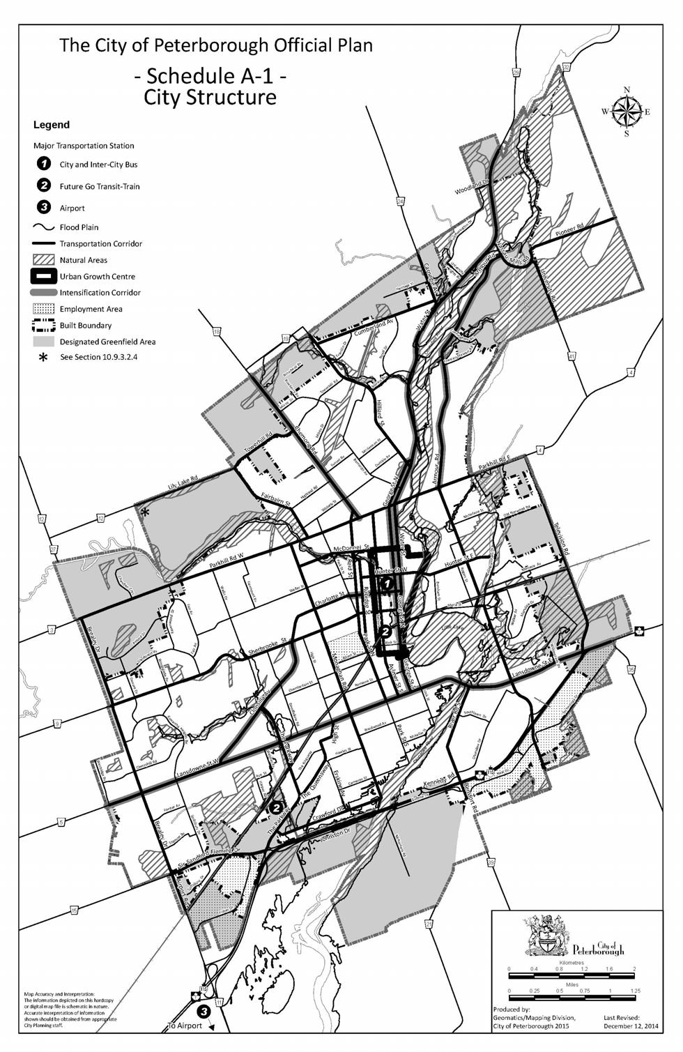
51
This page has been intentionally left blank.
 This page has been intentionally left blank. Chapter 3 3-2 3. Employment 3.A Niagara Economic Gateway 3.A.1 General The Niagara Economic Gateway comprises: a) The Gateway Economic Zone which includes all
A Growing Community Rural Settlement Areas
 Town of Huntsville Official Plan Review - POLICY BACKGROUND PAPER A Growing Community Rural Settlement Areas BACKGROUND: In addition to the fully municipally-serviced Urban Settlement Area and the Hidden
1 Introduction. Chapter. In this chapter:
 Chapter 1 Introduction In this chapter: 1.1 A Snapshot of the Region 1.2 Towards a Sustainable Region 1.3 The Provincial Context 1.4 Purpose and Organization The Regional Municipality of York Official
Growing Community Urban Settlement Area and Hidden Valley Settlement Area
 Town of Huntsville Official Plan Review - POLICY BACKGROUND PAPER Growing Community Urban Settlement Area and Hidden Valley Settlement Area BACKGROUND: Through the Provincial Policy Statement (PPS), the
Official Plan Review
 Official Plan Review Summary Report - The Built Environment August 2014 Part 1: Introduction Planning for a healthy, prosperous and sustainable community is an important goal for our municipality. From
Sustainable Growth. Sustainable Growth
 2 Sustainable Growth Sustainable Growth SUSTAINABLE GROWTH 2.1 COMMUNITY VISION... 2-5 2.2 THE CITY SYSTEM... 2-7 2.2.1 AREAS... 2-7 2.2.2 CITY-WIDE SYSTEMS... 2-8 2.2.3 PROVINCIAL PLAN BOUNDARIES AND
APPENDIX K WINDSOR OFFICIAL PLAN
 CEAA ENVIRONMENTAL ENVIRONMENTAL IMPACT ASSESSMENT AMBASSADOR BRIDGE ENHANCEMENT PROJECT Replacement Span and Plaza Expansion APPENDIX K WINDSOR OFFICIAL PLAN Avalon Consulting Professionals of Ontario,
PORT WHITBY COMMUNITY
 PORT WHITBY COMMUNITY SECONDARY PLAN UPDATE COMMUNITY IMPROVEMENT PLAN URBAN DESIGN GUIDELINES September 2015 DRAFT PROPOSED AMENDMENT NUMBER # to the Whitby Official Plan PURPOSE: The intent of this Amendment
THE GARDEN CITY PLAN. City of St. Catharines Official Plan. City of St. Catharines
 THE GARDEN CITY PLAN City of St. Catharines Official Plan City of St. Catharines August 2010 APPROVAL INFORMATION This Official Plan of the City of St. Catharines Planning Area, known as the Garden City
CITY OF LANGLEY OFFICIAL COMMUNITY PLAN BYLAW, 2005, NO APPENDIX II - REGIONAL CONTEXT MAP
 CITY OF LANGLEY OFFICIAL COMMUNITY PLAN BYLAW, 2005, NO. 2600 APPENDIX II - REGIONAL CONTEXT MAP ± Legend Agricultural Mixed Employment Industrial Conservation & Recreation Regional City Centre Urban Containment
The protection of the agricultural resources of the Province;
 PART II INTRODUCTION An Official Plan is a policy document, which is intended to serve as the basis for making land use decisions and managing change in any municipality in Ontario. According to the Planning
CITY CLERK. Parkland Acquisition Strategic Directions Report (All Wards)
") CITY CLERK Clause embodied in Report No. 10 of the, as adopted by the Council of the City of Toronto at its meeting held on November 6, 7 and 8, 2001. 10 Parkland Acquisition Strategic Directions Report
CITY CLERK Clause embodied in Report No. 10 of the, as adopted by the Council of the City of Toronto at its meeting held on November 6, 7 and 8, 2001. 10 Parkland Acquisition Strategic Directions Report
Plano Tomorrow Vision and Policies
 Plano Tomorrow Vision and Policies PLANO TOMORROW PILLARS The Built Environment The Social Environment The Natural Environment The Economic Environment Land Use and Urban Design Transportation Housing
6 Growth Management Challenges and Opportunities
 6 Growth Management Challenges and Opportunities The Town has established a goal of attaining a 50% participation rate with respect to employment opportunities versus residential population. The Town s
1.0 PLANNING MARKHAM S FUTURE CONTENTS
 1-1 Planning Markham s Future 1.0 PLANNING MARKHAM S FUTURE CONTENTS 1.1 THE PURPOSE OF THE OFFICIAL PLAN 1.2 THE MARKHAM CONTEXT 1.3 THE REGULATORY CONTEXT 1.3.1 Province of Ontario 1.3.2 York Region
Tāhuhu whakaruruhau ā-taone The sheltering ridge pole
 B2. Tāhuhu whakaruruhau ā-taone - Urban growth and form B2.1. Issues Tāhuhu whakaruruhau ā-taone The sheltering ridge pole Auckland s growing population increases demand for housing, employment, business,
THE STRUCTURE OF THE PLAN...
 TABLE OF CONTENTS THE STRUCTURE OF THE PLAN... 1 A1 THE COMMUNITY VISION... 3 A2 GOALS AND OBJECTIVES... 3 A2.1 THE NATURAL ENVIRONMENT... 3 A2.1.1 Goal... 3 A2.1.2 Objectives... 3 A2.2 GROWTH AND SETTLEMENT...
2040 LUP is a part of the Comprehensive Plan and carries the same legal authority. Economic Challenges
 1.1. Guiding Anchorage s Growth Where will new residents settle over the next two decades? Where will people work, shop, and play? Will there be enough room to grow? How will Anchorage look? Will growth
The West Vaughan Employment Area Secondary Plan Policies
 Part 2: The West Vaughan Employment Area Secondary Plan Policies 2.1 General Policies It is the policy of Council: 2.1.1. That the West Vaughan Employment Area (the WVEA), identified on Schedule 1, will
Visioning Statement and Guiding Principles
 Visioning Statement and Guiding Principles Planning for the Future The General Plan The General Plan represents Woodland's shared vision of the future and defines a path to lead the community toward its
Town of Cobourg Heritage Master Plan. Statutory Public Meeting
 Town of Cobourg Heritage Master Plan Statutory Public Meeting April 25 th 2016 Presentation Overview 1. Introduction 2. Project background and schedule overview 3. Review of strategic direction content
CONTENTS 2.0 A FRAMEWORK FOR SUSTAINABLE GROWTH 2.1 MANAGING SUSTAINABLE GROWTH THE VISION TO GOALS AND OBJECTIVES 2.3 MARKHAM STRUCTURE
 2 A Framework for Sustainable Growth 2.0 A FRAMEWORK FOR SUSTAINABLE GROWTH CONTENTS 2.1 MANAGING SUSTAINABLE GROWTH THE VISION TO 2031 2.2 GOALS AND OBJECTIVES 2.2.1 Protecting the Natural Environment
2.2.1 DOWNTOWN: THE HEART OF TORONTO
 2.2.1 DOWNTOWN: THE HEART OF TORONTO Toronto has only one downtown. It plays a vital role as the city s economic and cultural hub and is critical to the health and prosperity of the entire region that
Plan Modification to Chapter B2 of the Auckland Unitary Plan(AUP) Operative in part (15 November 2016)
 Operative in part (15 November 2016)") UNITARY PLAN UPDATE REQUEST MEMORANDUM TO FROM Phill Reid Linley Wilkinson DATE 25 September 2018 SUBJECT Plan Modification to Chapter B2 of the Auckland Unitary Plan(AUP) Operative in part (15 November
UNITARY PLAN UPDATE REQUEST MEMORANDUM TO FROM Phill Reid Linley Wilkinson DATE 25 September 2018 SUBJECT Plan Modification to Chapter B2 of the Auckland Unitary Plan(AUP) Operative in part (15 November
WITNESS STATEMENT Of. Ronald Blake. On behalf of the Intervenor The Corporation of the City of Markham
 Filed: 2013-06028 EB-2012-0451 Exhibit L.EGD.COM.2 Page 1 of 7 WITNESS STATEMENT Of Ronald Blake On behalf of the Intervenor The Corporation of the City of Markham In the matter of an application by Enbridge
2.0 A FRAMEWORK FOR SUSTAINABLE GROWTH CONTENTS
 2-2 A Framework for Sustainable Growth 2.0 A FRAMEWORK FOR SUSTAINABLE GROWTH CONTENTS 2.1 MANAGING SUSTAINABLE GROWTH THE VISION TO 2031 2.2 GOALS AND OBJECTIVES 2.2.1 Protecting the Natural Environment
City of St. Thomas New Official Plan
 City of St. Thomas New Official Plan Sustainable & Healthy Community Workshop Ann Joyner and Paddy Kennedy Dillon Consulting Limited Work Shop Outline Introduction Presentation Exercise 1 (individual)
SECTION ONE: INTRODUCTION. introduction
 introduction 1 INTRODUCTION Since it was first established in 1843 as a trading post for the Hudson s Bay Company, Victoria has evolved into a Provincial capital city that is recognized across Canada and
Concord Community Reuse Project Goals and Guiding Principles. Overarching Goals (OG)
") Concord Community Reuse Project Goals and Guiding Principles Overarching Goals (OG) No priority is implied by the order of presentation of the goals and guiding principles. Overarching goals for the Concord
Concord Community Reuse Project Goals and Guiding Principles Overarching Goals (OG) No priority is implied by the order of presentation of the goals and guiding principles. Overarching goals for the Concord
4 Sustainability and Growth Management
 4 Sustainability and Growth Management Introduction Traditionally, has assumed growth and development with limited consideration for the long-term negative social, environmental or economic impacts on
and services The protection and conservation of environmentally significant and sensitive natural heritage features and functions.
 6. Land Use 6.0 Preamble A healthy and livable city is one in which people can enjoy a vibrant economy and a sustainable healthy environment in safe, caring and diverse neighbourhoods. In order to ensure
Edward R. Sajecki Commissioner of Planning and Building
 Corporate Report Clerk s Files Originator s Files CD.03.POR DATE: TO: FROM: SUBJECT: Chair and Members of Planning and Development Committee Meeting Date: February 27, 2012 Edward R. Sajecki Commissioner
Trafalgar Road Corridor Planning Study Open House
 Trafalgar Road Corridor Planning Study Open House June 24, 2013 6:30-8:30 p.m. Oakville & Trafalgar Rooms Overview The Livable Oakville Plan identifies the lands along Trafalgar Road, between the QEW and
11.4 Highway 400 North Employment Lands Secondary Plan APPROVED BY THE ONTARIO MUNICIPAL BOARD ON NOVEMBER 21, 2011
 11.4 Highway 400 North Employment Lands Secondary Plan APPROVED BY THE ONTARIO MUNICIPAL BOARD ON NOVEMBER 21, 2011 11.4.1 General 11.4.1.1. as approved by the Ontario Municipal Board on November 21, 2011,
Public Open House. Overview of the Downtown Plan Official Plan Amendment April 23, 2018
 Public Open House Overview of the Downtown Plan Official Plan Amendment April 23, 2018 1 A 25-Year Plan for Downtown To ensure growth contributes positively to Toronto s Downtown as a great place to live,
QUEEN-RIVER SECONDARY PLAN
 34 QUEEN-RIVER SECONDARY PLAN 34. QUEEN RIVER SECONDARY PLAN 1. INTRODUCTION The Queen-River area is approximately 6.4 hectares and is located at the eastern edge of the Downtown as shown on Map 34-1.
13. VANDORF-PRESTON LAKE SECONDARY PLAN 13.1 INTRODUCTION
 13. VANDORF-PRESTON LAKE SECONDARY PLAN 13.1.1 Purpose 13.1 INTRODUCTION The Vandorf-Preston Lake Secondary Plan establishes the principles, objectives and general policies, as well as specific strategies
10.0 Open Space and Public Realm
 10.0 Open Space and Public Realm 10.0 Open Space and Public Realm The Public Open Space System is comprised of: outdoor spaces available for public use that are either publicly owned (e.g., parks and
5 Direct Growth. 5.1 Introduction
 5 Direct Growth 5.1 Introduction Mississauga s population and employment growth prospects are expected to remain strong over the next 25 years. Mississauga has sufficient land to accommodate projected
The Official Plan of The City of Brantford
 The Official Plan of The NOTE TO USERS The following document is an office consolidation of the Official Plan of the City of Brantford originally approved by the Minister of Municipal Affairs on November
NEW REGIONAL OFFICIAL PLAN HIGH LEVEL PROCESS & FRAMEWORK
 NEW REGIONAL OFFICIAL PLAN HIGH LEVEL PROCESS & FRAMEWORK Why A New Official Plan Originally the role of Regionally Planning and content of Regional Official Plan (1970s) primarily focused on protecting
Official Plan Review: Draft Built Form Policies
 PG.30.1 REPORT FOR ACTION Official Plan Review: Draft Built Form Policies Date: May 15, 2018 To: Planning and Growth Management Committee From: Chief Planner and Executive Director, City Planning Division
Appendix 1 Structure plan guidelines
 Appendix 1 Structure plan guidelines This appendix forms part of the regional policy statement [rps]. 1.1. Introduction Structure plans are an important method for establishing the pattern of land use
Figure 1- Site Plan Concept
 Figure 1- Site Plan Concept Parking will be provided underground on three levels at rate of 1.0 space/ unit; this rate includes all visitors parking. MMM Group has prepared a parking assessment (April,
CONTENTS 8.0 LAND USE 8.1 GENERAL LAND USE 8.2 RESIDENTIAL 8.3 MIXED USE 8.4 COMMERCIAL 8.5 EMPLOYMENT LANDS
 8-2 Land Use 8.0 LAND USE CONTENTS 8.1 GENERAL LAND USE 8.1.1 Uses provided for in all Land Use Designations 8.1.2 Uses prohibited in Hazardous Lands, Hazardous Sites and Special Policy Areas 8.1.3 Uses
AMENDMENT NO. 9 TO THE TOWNSHIP OF WILMOT OFFICIAL PLAN. The Corporation of the Township of Wilmot 60 Snyder s Road West, Baden, ON N3A 1A1
 AMENDMENT NO. 9 TO THE TOWNSHIP OF WILMOT OFFICIAL PLAN The Corporation of the Township of Wilmot 60 Snyder s Road West, Baden, ON N3A 1A1 AMENDMENT NO. 9 TO THE TOWNSHIP OF WILMOT OFFICIAL PLAN SECTION
2.0 A FRAMEWORK FOR SUSTAINABLE GROWTH CONTENTS
 2-2 A Framework for Sustainable Growth 2.0 A FRAMEWORK FOR SUSTAINABLE GROWTH CONTENTS 2.1 MANAGING SUSTAINABLE GROWTH THE VISION TO 2031 2.2 GOALS AND OBJECTIVES 2.2.1 Protecting the Natural Environment
The City of Guelph Official Plan
 The City of Guelph Official Plan 2018 Consolidation The City of Guelph Official Plan adopted by Council November 1, 1994 has been comprehensively updated through Official Plan Amendment (OPA) 39, OPA 42
The Five Components of the McLoughlin Area Plan
 The Five Components of the McLoughlin Area Plan This documents contains the complete language of the five components of the McLoughlin Area Plan: The Vision Statement The Values The Guiding Principles
Mark-up of the effect of the proposed Bronte Village Growth Area OPA No.18 on the text of section 24, Bronte Village, of the Livable Oakville Plan
 Mark-up of the effect of the proposed Bronte Village Growth Area OPA No.18 on the text of section 24, Bronte Village, of the Livable Oakville Plan Notes: This document is provided for information purposes
SECTION D. Citywide Policies
 SECTION D Citywide Policies 24 25 PART A - CITYWIDE PLAN - CITYWIDE POLICIES SECTION D Citywide Policies THIS SECTION PROVIDES POLICY DIRECTION BY TOPIC AREA: D1: Regional Context D2: Environment D3: Transportation
[PLANNING RATIONALE] For Site Plan Control and Lifting of Holding Zone By-Law 101 Champagne Avenue. May 23, 2014
![[PLANNING RATIONALE] For Site Plan Control and Lifting of Holding Zone By-Law 101 Champagne Avenue. May 23, 2014](/thumbs/75/71599615.jpg "[PLANNING RATIONALE] For Site Plan Control and Lifting of Holding Zone By-Law 101 Champagne Avenue. May 23, 2014") [PLANNING RATIONALE] For Site Plan Control and Lifting of Holding Zone By-Law 101 Champagne Avenue May 23, 2014 Contents 1.0 Introduction... 2 2.0 Site Context... 2 2.1 Adjacent Uses... 2 Figure 1: Site
[PLANNING RATIONALE] For Site Plan Control and Lifting of Holding Zone By-Law 101 Champagne Avenue May 23, 2014 Contents 1.0 Introduction... 2 2.0 Site Context... 2 2.1 Adjacent Uses... 2 Figure 1: Site
1 Introduction. 1.1 Background
 1 Introduction 1.1 Background Mississauga is at a decisive moment in its history most of its greenfield lands have been developed and much of its infrastructure is in place. New growth will take place
section 3: Vision, Values and Goals
 Vision, Values and Goals 3 2041 Vision: Victoria is an urban sustainability leader inspiring innovation, pride and progress towards greater ecological integrity, livability, economic vitality, and community
LAND USE ELEMENT. Purpose. General Goals & Policies
 LAND USE ELEMENT Purpose This Land Use Element contains the goals and policies necessary to support the City s responsibility for managing land resources and guiding development through implementing regulations,
SCHEDULE 'A' TO BY-LAW as Amended by AMENDMENT NO. 90 TO THE WHITBY OFFICIAL PLAN
 SCHEDULE 'A' TO BY-LAW 6413-10 as Amended by 6553-11 AMENDMENT NO. 90 TO THE WHITBY OFFICIAL PLAN SECTION A: GROWTH PLAN CONFORMITY PURPOSE: LOCATION: BASIS: The purpose of this Amendment is to: conform
Summary of Changes for the Comprehensive Draft Proposed Official Plan Amendment
 Summary of Changes for the Comprehensive Draft Proposed Official Plan Amendment Note: Due to the broad scope of the Official Plan Review, this list is not exhaustive of the extent of changes in the comprehensive
Transforming Saint John s Urban Heart -
 Transforming Saint John s Urban Heart - How Innovative Community Engagement Inspires a Bold Municipal Plan for a More Sustainable and Compact Saint John 2012 NNECAPA Conference - Brunswick, ME October
Section 1 Introduction
 Section 1 Section 1,, describes the role of the Official Plan. The Official Plan is one of five growth management plans that was completed under the umbrella of Ottawa 20/20. 1.1 The Role of the Official
{Best Practices. Summary of Tools, Strategies and Best Practices from 11 Michigan Case Study Communities
 Case Studies Michigan Coastal Community Working Waterfronts { Summary of Tools, Strategies and from 11 Michigan Case Study Communities Table of Contents Zoning...2 Community and Stakeholder Collaboration
CHAPTER 3 VISION, GOALS, & PLANNING PRINCIPLES. City of Greensburg Comprehensive Plan. Introduction. Vision Statement. Growth Management Goals.
 CHAPTER 3 VISION, GOALS, & PLANNING PRINCIPLES Introduction The Greensburg Comprehensive Plan is intended as a working community document. A combination of long and short-term goals, this document is intended
KAMPLAN City of Kamloops. Section D. Land Use Policies D-1
 KAMPLAN City of Kamloops Section D Land Use Policies D-1 City of Kamloops KAMPLAN D 1 Land Management and Development This section links to the following Community Values: D-2 develop complete neighbourhoods
OFFICIAL PLAN FOR THE TOWN OF NEW TECUMSETH
 OFFICIAL PLAN FOR THE TOWN OF NEW TECUMSETH Approved by Simcoe County- March 10, 2010 TABLE OF CONTENTS PAGE# 1.0 TITLE AND COMPONENTS... 5 2.0 INTRODUCTION... 6 2.1 Purpose... 6 2.2 Organization of the
Tremaine Dundas Secondary Plan (Draft May 2017)
") PB-52-17 Appendix A Tremaine Dundas Secondary Plan (Draft May 2017) Page 2 Tremaine Dundas Secondary Plan (Draft May 2017) This page has been left blank intentionally Page 3 Tremaine Dundas Secondary Plan
PB-52-17 Appendix A Tremaine Dundas Secondary Plan (Draft May 2017) Page 2 Tremaine Dundas Secondary Plan (Draft May 2017) This page has been left blank intentionally Page 3 Tremaine Dundas Secondary Plan
The lands identified as Residential Areas on Schedule A1, Urban Structure, represent the areas that provide for stable residential communities.
 Livable Oakville Part D: Land Use Designations and Policies 11. RESIDENTIAL 11.1 General The lands identified as Residential Areas on Schedule A1, Urban Structure, represent the areas that provide for
Urban Design Manual PLANNING AROUND RAPID TRANSIT STATIONS (PARTS) Introduction. Station Study Areas
 Introduction. Station Study Areas") 111111 PLANNING AROUND RAPID TRANSIT STATIONS (PARTS) Introduction The ION rapid transit system will link Waterloo, Kitchener and Cambridge through a central transit corridor (CTC). There are a number
111111 PLANNING AROUND RAPID TRANSIT STATIONS (PARTS) Introduction The ION rapid transit system will link Waterloo, Kitchener and Cambridge through a central transit corridor (CTC). There are a number
Chapter 1. Community Context. Vision Statement Population and Housing Trends Legislative Context Regional Context Statement
 Chapter 1 Community Context Vision Statement Population and Housing Trends Legislative Context Regional Context Statement 1.1 VISION STATEMENT CORPORATE MISSION STATEMENT To promote a safe and livable
MAYFIELD WEST SECONDARY PLAN PHASE 2
 MAYFIELD WEST SECONDARY PLAN PHASE 2 Public Open House #3 February 25, 2010 Draft Preferred Land Use Scenario TOWN OF CALEDON PLANNING & DEVELOPMENT DEPARTMENT Open House Agenda TOWN OF CALEDON 1. Welcome
FORMER CANADIAN FORCES BASE (CFB) ROCKCLIFFE SECONDARY PLAN. Official Plan Amendment XX to the Official Plan for the City of Ottawa
 ROCKCLIFFE SECONDARY PLAN. Official Plan Amendment XX to the Official Plan for the City of Ottawa") FORMER CANADIAN FORCES BASE (CFB) ROCKCLIFFE SECONDARY PLAN Official Plan Amendment XX to the Official Plan for the City of Ottawa 1 INDEX THE STATEMENT OF COMPONENTS PART A THE PREAMBLE PAGE Purpose...
FORMER CANADIAN FORCES BASE (CFB) ROCKCLIFFE SECONDARY PLAN Official Plan Amendment XX to the Official Plan for the City of Ottawa 1 INDEX THE STATEMENT OF COMPONENTS PART A THE PREAMBLE PAGE Purpose...
Niagara Region Official Plan. Table of Contents
 Niagara Region Official Plan Table of Contents This page has been intentionally left blank. Table of Contents ii Niagara Region Official Plan Niagara Region Official Plan - Table of Contents Chapter 1
TOWN OF SAUGEEN SHORES OFFICIAL PLAN
 TOWN OF SAUGEEN SHORES OFFICIAL PLAN Adopted by Council: December 10, 2012 Approved by County of Bruce: March 26, 2014 (Office Consolidation September 2014) Town of Saugeen Shores 1 Table of Contents Saugeen
DRAFT WESTERN CITY DISTRICT PLAN PLANNING PRIORITIES AND ACTIONS
 Greater Sydney Commission DRAFT WESTERN CITY DISTRICT PLAN PLANNING PRIORITIES AND ACTIONS Issued: 26 OCTOBER 2017 Version: 1 Subject: Greater Sydney Region and District Plans This information note is
TABLE OF CONTENTS INTRODUCTION PLAN CONCEPT... 3
 TABLE OF CONTENTS BY-LAW NO. Z-1 INTRODUCTION... 1 1.0 PLAN CONCEPT... 3 1.1 Mission... 3 1.2 A Future Vision for Fredericton... 3 1.3 Growth Strategy Goals... 5 National Context... 5 Provincial Context...
CITY OF BARRIE OFFICIAL PLAN (APRIL 2010)
") CITY OF BARRIE OFFICIAL PLAN (APRIL 2010) On April 23, 2010, The Ministry of Municipal Affairs and Housing (MMAH) approved a new Official Plan for the City of Barrie. The MMAH modifications are referenced
CITY OF BARRIE OFFICIAL PLAN (APRIL 2010) On April 23, 2010, The Ministry of Municipal Affairs and Housing (MMAH) approved a new Official Plan for the City of Barrie. The MMAH modifications are referenced
THE CORPORATION OF THE CITY OF WINDSOR Office of the City Solicitor Planning Department
 THE CORPORATION OF THE CITY OF WINDSOR Office of the City Solicitor Planning Department REPORT TO THE CITY OF WINDSOR PLANNING ADVISORY COMMITTEE DATE OF REPORT: August 19, 2010 SUBJECT: Official Plan
DRAFT GREATER SYDNEY REGION PLAN OBJECTIVES, STRATEGIES AND ACTIONS
 Greater Sydney Commission DRAFT GREATER SYDNEY REGION PLAN OBJECTIVES, STRATEGIES AND ACTIONS Issued: 26 OCTOBER 2017 Version: 1 Subject: Greater Sydney Region and District Plans This information note
5.0 VILLAGE AREAS. February 2008 Municipality of West Elgin ~ Official Plan 5-1
 5.0 VILLAGE AREAS This section of the Official Plan deals with the villages of Rodney and West Lorne being the two largest and only fully serviced settlement areas in West Elgin and the most logical and
Toronto Complete Streets Guidelines
 Toronto Complete Streets Guidelines 108 110 7.1 Green Infrastructure Design Principles 112 7.2 Context-Sensitive Green Streets 114 7.3 Key Green Street Elements Green infrastructure refers to natural and
CHAPTER 2 GOALS, OBJECTIVES AND POLICIES
 CHAPTER 2 GOALS, OBJECTIVES AND POLICIES The goals, objectives and policies of this Comprehensive Plan Update serve as guidelines for directing future growth, revitalization, development, adaptive reuse
SAN RAFAEL GENERAL PLAN 2040 INTRODUCTION AND OVERVIEW
 SAN RAFAEL GENERAL PLAN 2040 INTRODUCTION AND OVERVIEW Steering Committee Presentation February 14, 2018 Purpose of General Plan Guide land use and development decisions Coordinate transportation, infrastructure,
PSRC REVIEW REPORT & CERTIFICATION RECOMMENDATION
 PSRC REVIEW REPORT & CERTIFICATION RECOMMENDATION KITSAP COUNTY COUNTYWIDE PLANNING POLICIES July 2, 2012 BACKGROUND A major emphasis of the Washington State Growth Management Act (GMA) is the need to
Our City Centre is a vibrant, creative and welcoming destination, with a modern business, cultural, shopping, leisure and residential offer
 3. Sheffield in 2034 Our City sits at the heart of a strong, distinctive and internationally successful City Region economy which supports innovation and enterprise Our City Centre is a vibrant, creative
Attachment 1, Schedule 1: Draft Official Plan Amendment. Planning and Growth Management Item ~ as adopted by City of Toronto Council on ~, 20~
 Attachment 1, Schedule 1: Draft Official Plan Amendment Authority: Planning and Growth Management Item ~ as adopted by City of Toronto Council on ~, 20~ Enacted by Council: ~, 20~ CITY OF TORONTO Bill
1.3 TRANSIT VISION 2040 FROM VISION TO ACTION THEME 1: PUTTING TRANSIT AT THE CENTRE OF COMMUNITIES. Fully integrate transit with community planning
 TRANSIT VISION 2040 FROM VISION TO ACTION TRANSIT VISION 2040 defines a future in which public transit maximizes its contribution to quality of life with benefits that support a vibrant and equitable society,
178 Carruthers Properties Inc.
 178 Carruthers Properties Inc. Planning Rationale for 178 Carruthers Avenue Site Plan Control Application June 2014 Table of Contents 1.0 Introduction 2.0 Overview of Subject Property 3.0 Current Zoning
MAYFIELD WEST SECONDARY PLAN PHASE 2
 MAYFIELD WEST SECONDARY PLAN PHASE 2 Council Information Workshop February 16, 2010 Draft Preferred Land Use Plan TOWN OF CALEDON PLANNING & DEVELOPMENT DEPARTMENT Workshop Agenda TOWN OF CALEDON 1. Welcome
Planning Primer Legislative Background, Policy Documents and Development Review Processes. Presented by: Planning Services Date: April 6, 2017
 Planning Primer Legislative Background, Policy Documents and Development Review Processes Presented by: Planning Services Date: April 6, 2017 Agenda Legislative Background 7:30 to 8:00 pm Questions 8:00
Complete Neighbourhood Guidelines Review Tool
 Complete Neighbourhood Guidelines Review Tool Prepared By: City of Regina Planning Department October 2014 Page 1 of 14 Community Development Review Checklist for Secondary Plans and Concept Plans The
6 PORT SYDNEY SETTLEMENT AREA
 Section 6 Port Sydney Page 61 6 PORT SYDNEY SETTLEMENT AREA 6.1 Basis and Principles Village of Port Sydney Waterfront Community Existing Services 6.1.1 Port Sydney is an historic settlement that has developed
K. SMART ASSOCIATES LIMITED
 Planning Justification Report Zoning By-Law Amendment 185 King Street North Waterloo, Ontario April 7th, 2017 Project Reference Number 16-245 K. SMART ASSOCIATES LIMITED CONSULTING ENGINEERS AND PLANNERS
2. Shaping Waterloo Region s Urban Communities
 2. Much of the region s growth over the past several decades has occurred in suburban areas that separated where people live from where they work and shop. This pattern of growth has increased the need
Regional Context Statement
 Regional Context Statement REGIONAL CONTEXT STATEMENT 3. REGIONAL CONTEXT STATEMENT In 1995, the Provincial Government passed into law the Growth Strategies Act. The purpose of this provincial initiative
New Official Plan Quest November 2013
 City of Markham New Official Plan Quest November 2013 Building Markham s Future Together - 6 Key Strategic Priorities 1. Growth - Managing our Growth 2. Transportation/Transit - Improving transportation
Municipal Development Plan 2013
 UNIQUELY STONY PLAIN: Municipal Development Plan 2013 Quick Reference Guide What is a Municipal Development Plan (MDP)? The Town s highest-level planning document Sets the long-term vision and key themes
Arlington, Virginia is a worldclass
 EXECUTIVE S U M M A RY Arlington maintains a rich variety of stable neighborhoods, quality schools and enlightened land use policies, and received the Environmental Protection Agency s highest award for
SUBJECT: GO Station Mobility Hubs Preferred Concepts: Aldershot GO, Burlington GO and Appleby GO. Planning and Development Committee - Public Meeting
 Page 1 of Report PB-76-17 SUBJECT: GO Station Mobility Hubs Preferred Concepts: Aldershot GO, Burlington GO and Appleby GO TO: FROM: Planning and Development Committee - Public Meeting Planning and Building
and Richmond Street West - Official Plan Amendment Application - Preliminary Report
 STAFF REPORT ACTION REQUIRED 822-838 and 860-862 Richmond Street West - Official Plan Amendment Application - Preliminary Report Date: August 14, 2017 To: From: Wards: Reference Number: Toronto and East
COMMUNITY SUSTAINABILITY AND ENVIRONMENTAL MASTER PLAN IMPLEMENTATION UPDATE
 Attachment 1 COMMUNITY SUSTAINABILITY AND ENVIRONMENTAL MASTER PLAN IMPLEMENTATION UPDATE Priorities and Key Initiatives Committee May 2013 Page E-1 How we grow Goal 2: To ensure sustainable development
Table 8-4: Road Classification Local Roads, second table, of Chapter 8 Create a Multi-Modal City, be amended by adding the following:
 1 Port Street East Official Plan Amendment APPENDIX 3 Amendments to Mississauga Official Plan Table 8-4: Road Classification Local Roads, second table, of Chapter 8 Create a Multi-Modal City, be amended
CITY OF COLWICH COMPREHENSIVE PLAN LAND USE LAND USE 1
 LAND USE LAND USE 1 WHAT YOU WILL FIND IN THIS CHAPTER: Discussion of today s conditions and tomorrow s projections Discussion of challenges and opportunities Discussion of the environmental quality goals,