Supports Item No. 2 P&E Committee Agenda November 18, 2010
|
|
|
- Kory Parker
- 5 years ago
- Views:
Transcription

1 Supports Item No. 2 P&E Committee Agenda November 18, 2010 POLICY REPORT DEVELOPMENT AND BUILDING Report Date: November 02, 2010 Contact: Peter Burch Contact No.: RTS No.: VanRIMS No.: Meeting Date: November 18, 2010 TO: FROM: SUBJECT: Standing Committee on Planning and Environment Director of Planning, in consultation with the General Manager Park Board, General Manager of Engineering Services, Managing Director of Cultural Services, and Managing Director of Social Development. Mount Pleasant Community Plan RECOMMENDATION A. THAT the document entitled "DRAFT Mount Pleasant Community Plan" (attached as Appendix A) be adopted to guide future plans, policies, actions, and other initiatives in Mount Pleasant. B. THAT staff proceed with the implementation of the Mount Pleasant Community Plan, including the development of a strategy for revitalizing Broadway East, a community-wide public benefits and infrastructure strategy and public realm plan, and an investigation of public engagement alternatives for implementing the Plan, in accordance with Plan principles and policies and in consultation with the local community. GENERAL MANAGER'S COMMENTS The General Manager of Community Services RECOMMENDS approval of the forgoing. COUNCIL POLICY Mount Pleasant Community Plan, 1987 CityPlan, 1995 Transportation Plan, 1997 Homeless Action Plan, 2005 Social Sustainability Policy, 2005 Main Street Corridor Plan, 2006
2 Mount Pleasant Community Plan Supportive Housing Strategy, 2007 Heritage Register Upgrade Program, 2007 EcoDensity, 2008 Culture Plan, 2008 Cultural Facilities Priorities Plan, 2008 Metropolitan Core Jobs and Economy, on-going Greenest City Initiative, on-going UBC Line Rapid Transit Study, on-going Housing Strategy, on-going PURPOSE AND SUMMARY This report seeks Council approval of the Mount Pleasant Community Plan. The Mount Pleasant Community Plan includes: Overarching Principles which set out the overall goals of the community plan the basis for future plans, policies, actions, and other initiatives; Policies Addressing Key Issues policies, actions, and other initiatives related to housing, transportation, heritage, character, safety, services, and culture; and Shopping Sub-area Plans and Policies. The report also discusses community projects undertaken to address key social issues identified by the community and endorsed by Council through the Community Action Agenda. The report includes background information on the planning process including key process principles and the policy context within which the process was carried out including the Greenest City initiative, the Metropolitan Core Jobs and Economy Study, the Cultural Plan, and the UBC Rapid Transit Line study. The report concludes with a description of the processes needed to implement the Mount Pleasant Community Plan, including a set of initial steps referred to in this report s recommendations: a strategy for revitalizing the area referred to in the Plan as Broadway East; development of a public benefits strategy and public realm plan for all of Mount Pleasant; and an investigation of public engagement alternatives for implementing the Plan, in accordance with Plan Directions and in consultation with the local community. BACKGROUND Study Area The Mount Pleasant local area is bounded by Cambie Street to the west, 16th Ave. to the south, Clark Dr. to the east, and Great Northern Way/False Creek to the north. The Community Plan will focus on the area shown in Map 1.

3 Mount Pleasant Community Plan Map 1 Land use policy and urban design in the remainder of the Mount Pleasant local area is, or will be, addressed through other initiatives: South East False Creek: the Olympic Athletes Village and the other lands north of 2 nd Ave. will be guided by the recently adopted Official Development Plan; Cambie Street: Public realm improvements along Cambie St. within Mt. Pleasant were constructed as part of the completion of the Canada Line project; land use and urban design issues will be dealt with through future station area planning. Additional planning for the Cambie St. commercial frontage, will be incorporated in future planning (e.g. Metro Core Jobs and Economy Study, and Fairview Community Planning); Mount Pleasant Industrial Area: Future land use of this area, generally bounded by Quebec St., Broadway, Yukon St., and 2 nd Ave., will be addressed in the Metro Core Jobs and Economy Study; and Kingsway and Fraser St.: The small commercial node at Kingsway and Fraser St. will be combined with the larger commercial area on Kingsway and Fraser St. to the south of 16 th Ave. in a future Neighbourhood Centre or similar planning program. Area Description Population: Mount Pleasant has a population of 23,615 people. Between 1996 and 2006, the population of Mount Pleasant experienced a marginal decrease of 3.4%. In comparison, the overall population of Vancouver increased by 12.5% during the same period. The number of children in Mount Pleasant aged 0 to 19 changed significantly, dropping by 24.4% (city-wide: increased by 4.5%). The number of young adults in
4 Mount Pleasant Community Plan Mount Pleasant aged 20 to 39 also dropped significantly at 11.4% between 1996 and 2006 (City-wide: marginal increase by 1%). Language: In 2006, 62% of Mount Pleasant residents identified English as their mother tongue, up from 57% in Chinese speakers accounted for nearly 11% of Mount Pleasant residents in Other languages spoken in Mount Pleasant include Tagalog 5.5%; Vietnamese 3%; and, French 2%. Income: The median household income for Mount Pleasant is $37,782 which is 20% below the city median of $47,299. About 32% of Mount Pleasant residents are considered low-income, which is above the citywide figure of 27%. The proportion of Mount Pleasant families led by a single parent was 18.6% in 2006 (city-wide 16%). In 2006, one in three Mount Pleasant households found themselves paying 30% or more of their gross income for suitable and adequate housing. Housing: Multi-family housing (which includes duplex, rowhouse, and apartments) accounts for 94% of Mount Pleasant s dwelling types compared to 80% city-wide. Single family houses (including houses with secondary suites) comprise only 3.8% of Mount Pleasant s dwelling types, much lower than the city-wide average of 19%. In 2006, approximately 67% of Mount Pleasant residents rented their homes, with an average monthly shelter cost of $765 (2007), 24% below the City average of $945. Home ownership levels increased in Mount Pleasant between 1996 and 2006, from 28% to 33%, still well below the city-wide average of 48%. Parks: Mount Pleasant has nine parks, for a total of 9.96 hectares, yielding a ratio of 0.44 hectare of park per 1,000 residents. This is well below the target for park space of 1.1 hectares (2.75 acres) per 1,000 residents. Heritage: Mount Pleasant has 22 A, 100 B and 69 C listed buildings, yielding a total of 191 Vancouver Heritage Register buildings, 9% of the total number listed. Culture: Mount Pleasant has 53 arts primary cultural facilities (e.g., not including restaurants, pubs, or community centres) out of a total city-wide of 488. It is one of the top four areas for culture in the City Mount Pleasant Community Development Plan In 1989, the Mount Pleasant Community Development Plan was adopted by City Council. Its overall goal was to improve the general social and physical environment of the community, and included directions on housing, commerce and employment, heritage, parks, traffic, the environment, and social development. Plan implementation resulted in new zoning for Mount Pleasant s industrial, commercial, and residential areas (duplex and apartment areas), and included actions respecting prostitution, public health, culture, heritage, parks, and extensive traffic calming. Current Community Plan Process The Community Plan process consisted of three main steps. These activities and steps are described below. In total, planning fairs, workshops, and open houses attracted over 2000


5 Mount Pleasant Community Plan people. For a more complete description of the events and meetings held during the public process, please see Appendix B. Step 1: Start-up and Getting in Touch This step included initial outreach to community groups, businesses, and service agencies; an initial newsletter; and recruitment of members for a Community Liaison Group (CLG). A Feedback Form seeking community input on priorities for action was developed. This was a starting point for community discussion and it helped shape the issues and opportunities addressed in the program. Two Community Plan Fairs were held as kick-off events to increase community awareness of the program, publicize opportunities to participate, and help set priorities for subsequent program steps. Step 2: Workshops and Community Action Projects a. Shopping Area Plans and Policies for Key Themes The Shopping Area Plans involved concurrent work on the three existing shopping areas and for the light industrial/commercial area on Main Street from 2nd to 7 th Aves. The Key Themes explored in the planning process included Housing, Transportation, Safety and Services, Parks and Open Space, Heritage and Character, and Culture. To produce these plans and policies, the process steps included: reviewing existing issues and policy, and land use and transportation patterns in Mount Pleasant; discussing needs, challenges, and opportunities in a series of public workshops, open houses, focus groups, and other engagement vehicles;
6 Mount Pleasant Community Plan urban design analysis of built form options, including alternative land uses, public realm, traffic and parking, and public open space opportunities. b. Community Action Agenda/Projects This part of the program focussed on taking coordinated action on pressing social issues. The main steps included: drafting a Community Action Agenda based on Feedback Form responses; forwarding the Community Action Agenda to Council for approval; forming a Social Coordinating Group (SCG) of key stakeholders; developing action plans for specific community projects; recruiting additional working group members to implement action projects/plans; implementing 12 projects to address 4 key social issues: homelessness; support for the vulnerable; open alcohol, drug, and sex trade; and community safety and security; and coordinating and monitoring project implementation. Step 3: Open Houses and Completing the Plan At this stage all the elements of Mount Pleasant s Community Plan were brought together for broad community validation and Council approval. The main steps included: a final broad public review of the draft Community Plan through a series of five Open Houses held across the community; modifying and refining the draft Plan based on feedback; and presenting the draft Plan to Council for adoption. Policy Context and Key Questions to Answer The Mount Pleasant Community Plan is integrated with many City initiatives. These include: Greenest City, the Homeless Action Plan and other related policies, the emerging Rental Housing policies, the Metro Core Jobs and Economy Study, Transportation Plan, City Plan, the UBC Rapid Transit Line, the Social Sustainability Policy, the Heritage Register Upgrade Program, and the City of Vancouver Cultural Plan, and Cultural Facilities Priorities Plan. Alongside these initiatives are a set of Council priorities homelessness and affordable housing; building strong, safe, and inclusive communities; environment and sustainability; and creative capital and a growing economy which provide further guidance to the planning process. Planning process principles accepted by the community included balancing the rights and uniqueness of the community with its responsibility as part of the City and Region, and that new plans and policies strive to be consistent with city-wide plans, policies, and initiatives. In recognition of this principle, the Mount Pleasant Community Plan has endeavored to respond to the following questions: What is distinctive and highly valued about the Mount Pleasant neighbourhood? How can Mount Pleasant become Vancouver s greenest, most sustainable neighbourhood? Where should higher density development be located in Mount Pleasant?
7 Mount Pleasant Community Plan How can Mount Pleasant address the needs of homeless people? How should we strengthen Mount Pleasant s neighbourhood centres and shopping areas? How can we support more walking, biking, and transit use? How can we preserve and promote Mount Pleasant s heritage? How can we promote arts and culture in Mount Pleasant? How can Mount Pleasant become a socially sustainable community? The current policy context, together with Council priorities, will continue to evolve over the lifetime of the Mount Pleasant Community Plan. New policies and priorities may come forward to inform and guide the community plan s implementation. In responding to the policy context especially in areas of mostly provincial or federal jurisdiction the community plan recognizes the need for partnerships, particularly the areas of housing, services, and regional transportation. Support from relevant federal and provincial ministries and agencies, regional health authorities, and TransLink would be preconditions for fully implementing some community plan policy. Some community plan policies can be implemented more quickly, closely aligned with existing city policy, priorities, and programs (e.g., traffic calming, business improvement area assistance, park improvements, bikeways, and greenways). Other plan policy may take shape over many years, requiring the assembly of city resources and/or further co-operation with senior levels of government to pursue implementation. The community plan will help to set priorities and to direct funds to programs which achieve policy over time. The community plan also provides the community with a framework for action and volunteer initiatives. Continued community involvement will be necessary to set priorities and provide leadership over the life of the community plan. Further discussion regarding plan implementation occurs later in this report. DISCUSSION Mount Pleasant Community Plan: Summary This section summarizes key principles, plans, policies, actions, and other initiatives established within the Community Plan. For more detail, refer to the draft Community Plan contained in Appendix A. In cases where a proposed principle, plan policy, or action has raised concerns within the local community, it is referenced and staff's policy recommendations outlined under the heading Community Concerns.

 for low income families and individuals. b.")
8 Mount Pleasant Community Plan Overarching Principles The Mount Pleasant Community Plan establishes a number of overarching principles which set out the overall goals of the community plan, summarized as follows: a. Housing and Population Mix Provide more housing and more affordable housing in Mount Pleasant with a variety of tenures and housing types to suit a diversity of people; retain older more affordable housing (e.g., 3 storey walk-ups) for low income families and individuals. b. Economic Development and Revitalization Recognize four distinct shopping areas in Mount Pleasant, and develop a strategy (including added density and height) to attract development that will meet local needs and respond to the character of the neighbourhood; consider Broadway East as the highest priority for revitalization. c. Character and Built Form Conceive of Mount Pleasant as a distinctive hilltown area with a heritage heart at Broadway, Main, and Kingsway, and slopes as natural form-makers; pursue a high-low massing rhythm across the hill town, but with modest height as the norm; find ways for contemporary design to fit into the neighbourhood; and develop Watson Street as a special place. d. Large Site Development Pursue additional height and density in select locations in Mount Pleasant particularly near transit hubs - to achieve more appropriate site development and important public benefits, contingent on further urban design analysis, including respecting the character of adjacent streets. e. Parks and Public Realm Address the constraints on larger park development by increasing vertical gardens, linear parks, pocket parks, courtyards, patios, and rooftop terraces; provide opportunities for farmer s markets and other outdoor events/celebrations; and explore opportunities for daylighting Mount Pleasant s streams. f. Laneways
9 Mount Pleasant Community Plan Animate Mount Pleasant s lanes that provide key pedestrian and cyclist links with more pedestrian and cyclist use, architecturally innovative new development, laneway-facing studios or other small businesses, public art, and urban agriculture, while still addressing servicing needs. g. Transportation Develop a pedestrian-, cyclist-, and transit-oriented community, with improved linkages or routes, and safety, and explore ways to accommodate roller-bladers, wheelchair/scooters, and skateboarders; mitigate the impacts of traffic and parking on the livability of Mount Pleasant. h. Heritage Recognize and preserve Mount Pleasant s heritage assets, ensuring that heritage preservation includes programming and promotion of heritage activities, and honour the history, traditions, and current presence of Aboriginal peoples and sites with tangible support for Aboriginal projects and initiatives. i. Culture Retain existing and develop new gathering, creation, production, and support spaces for cultural, social, and economic activities; and create and display a diversity of public art. j. Community Services and Development Welcome, engage, and integrate newcomers; maintain population diversity; distribute services fairly within the neighbourhood and across the City, including those for at-risk groups; model best practices to reduce the risk of crime; and promote universal design. k. Public Engagement Build community capacity throughout the planning and development processes, ensuring that the process seeks common ground and reflects the interests of the broad community; and investigate public engagement alternatives for collaboration when implementing the Plan. Community Concern 1: Policy directions which received strong support during the community planning process were creating a neighbourhood panel to work with architects and developers to find a good way for contemporary design to fit in to Mount Pleasant s older neighbourhoods, and using co-design processes for all new public realm assets to ensure they are well-conceived, well-implemented, and wellused. As suggested in the Overarching Principles, staff support as a first step an investigation by City planners into the various models and best practices used in other neighbourhoods and municipalities to collaborate on design solutions and community plan implementation. This would be followed by further dialogue with community stakeholders to jointly determine the best approach to adopt in Mount Pleasant. Policies Addressing Key Issues The Mount Pleasant Community Plan contains policies, actions, and other initiatives addressing issues of housing, character, parks, services, safety, transportation, heritage, and culture. These policies are largely directed at the City of Vancouver as the most significant
10 Mount Pleasant Community Plan policy-maker, regulator, and sometimes funder of projects related to the key issues, and are more focused (i.e., by location, action, or actor) than the overarching principles discussed above. As discussed above, senior levels of government and their agencies have a role to play in the implementation of policies respecting housing, services, and transportation. a. Housing Encourage the construction of more affordable housing, including new market rental housing, by exploring a variety of measures including seeking partnerships with senior levels of government, and research best practices for integrating at-risk groups into the neighbourhood. Investigate creating a shopping and residential hub at Broadway and Clark, increase affordable housing along Broadway between Main and Clark, and encourage housing on lanes. Strengthen and enforce standards for building maintenance, and encourage residents to maintain their buildings. b. Character Investigate opportunities to increase the quality, sustainability, variety, and innovation in design of new housing being built in Mount Pleasant; explore impacts of reducing the size (height and bulk) of new duplexes (including likely impacts on unit size, property values, and carbon footprint); and improve guidelines for heritage design reflecting the character of heritage buildings - in Mount Pleasant s apartment and duplex areas. c. Parks and Open Space Improve Mount Pleasant s parks by, for example, providing more space for arts and culture in parks, more public washrooms, and more opportunities for urban food growing/education; and in Jonathan Rogers and Guelph Parks, provide a skateboard and bike park, and an enclosed off-leash area. Create one new central neighbourhood square (with covered area), and turn open space at Mount Pleasant Elementary School into a special gathering space. d. Services Provide support for Mount Pleasant s children and youth, and intergenerational support, linking seniors with young families; provide adequate space for seniors programming in Mount Pleasant; and deliver services and facilities to support immigrants in Mount Pleasant. Seek to prevent homelessness before it happens with the timely provision of support services, but continue to support efforts to house the homeless in Mount Pleasant, with the provision of support services; and ensure the community is engaged by the City, provincial government, and/or other actors when implementing programs for the homeless. Encourage property owners and occupants to keep adjacent streets and lanes litterfree, and to maximize recycling and composting opportunities within each property; ensure air and waste water quality regulations are followed in light industrial areas in Mount Pleasant.
11 Mount Pleasant Community Plan e. Safety Continue City s practice of having eyes-on-the-street, improving lighting on streets and sidewalks through existing programs, and implementing the City s Four Pillars Program; strengthen the Mount Pleasant s Community Policing Centre. f. Walking, Biking, and Parking Explore opportunities to address issues related to traffic calming and provide street improvements for walking and biking through redevelopment and existing programs; and review the potential for reducing parking requirements to reduce housing costs and car use while mitigating neighbourhood impacts. Continue to support improved pedestrian and bicycle linkages both within Mount Pleasant and connecting to surrounding neighbourhoods, including SE False Creek, False Creek Flats, and Strathcona. g. Transit Provide transit improvements, including supporting rapid transit to UBC. Examine the potential of extending Vancouver s street car network up Main Street to 13 th Avenue as part of the new Transportation Plan. Locate the anticipated transit station for GNWC on the north side of Great Northern Way, positioned to be integrated with new development, including safe pedestrian access and connectivity between the station and other Mount Pleasant destinations. h. Heritage Consider making Mount Pleasant a heritage area providing a detailed description of Mount Pleasant s heritage assets - as a means to better protect and enhance its heritage resources; upgrade the heritage register; enhance Brewery Creek s historical significance; and increase the incentives/regulation relaxations for heritage retention (including transfer of density within Mount Pleasant). i. Culture Enable the sustainable creation and operation of cultural spaces including addressing issues which constrain artistic occupations and activities, including zoning, licensing and various guidelines, and promote diverse cultural programming of events. Shopping Sub-Area Plans and Policies The Mount Pleasant Community Plan contains plans and policies for Mount Pleasant s three shopping sub-areas Uptown, Broadway West, and Broadway East - and the light industrial/commercial area located on Main from 2 nd Ave. to 7 th Ave. (see Map 1). Within these sub-areas are locations where additional density and height could be pursued to achieve more appropriate site development and important public benefits. A variety of built form options could be appropriate on these sites; any additional height and density would be contingent on further urban design analysis, including shadowing, view impacts, and the look and feel of the area. It is important to note that community feedback indicates that allowing for additional height (as opposed to density) is still a very sensitive issue with the least convergence of community opinion. Future development will need to demonstrate how to reach an optimal balance of
12 Mount Pleasant Community Plan public benefits, site improvements, and urban design objectives with higher densities in low-, medium-, and, on selected sites, high-rise forms of development. New residential development should serve, in part, communities with housing needs (e.g., low to middle income families, seniors, artists) by providing a variety of housing types (e.g., more rental, social or artist live-work units, row housing, 3-bedroom units for families, or cooperatives). Large sites are encouraged to expand job space (retail; office professional), provide more services, and locate parking underground. The Plan supports the design of iconic (landmark) buildings when granting permission for higher buildings. New development should distinguish itself from predominant forms of development in other parts of the City. a. Uptown Shopping Area Retain the existing scale and character of Main Street (from 7 th Ave. to 11 th Ave.); Create a Cultural District north of Broadway; Use possible transit station (for UBC Rapid Transit) to improve pedestrian linkage between areas located north and south of Broadway; Increase permitted residential (with some commercial space) in locations south of Broadway on Kingsway, and use contributions from redevelopment for heritage retention, cultural amenities, public realm improvements, and other public benefits. Key Uptown sites on Kingsway include the Rize Alliance Development Site (bounded by Broadway, Kingsway, Watson St., and 10th Avenue) and the Kingsgate Mall. Allow additional density and height for mixed-use buildings on the the IGA site at 13 th Ave. and Main St., and allow buildings of up to 6 storeys to increase housing opportunities along South Main (from 12 th to 16 th Aves.). b. Main 2nd to 7th Encourage new development along Main (2 nd to 7 th Avenues) with a mix of residential, office, and retail uses, and small public open spaces and plazas; Do not construct the Kingsway Connector, intended to extend Kingsway to Quebec Street at 5 th or 6 th Aves., using the land for open space, housing, and mixed-use development instead; and Allow up to 6 storeys for mixed-use developments, with buildings above 6 storeys considered at the intersections of Main St. with 2nd Avenue and with 7 th Avenue. Community Concern 2: the community expressed concerns about allowing buildings above 6 storeys at the intersections of Main St. with 2 nd Avenue and with 7 th Avenue. The concern is in recognition of potential impacts on views especially at Main St. and 7 th Ave. - and overshadowing of adjacent areas, along with changes to the character of the street. Further work will be required on this issue when a rezoning process occurs. The rezoning process must demonstrate how the additional height serves to improve site development and street character, and provide public benefits, without compromising the hill town urban design concept, important public views, and sun access to the street. Consider opportunities to alter the view cone in order to allow taller buildings along the east side of Main Street and better promote the area as a mixed-use urban village. The present configuration may restrict development at 6 th and 5 th Aves. (allowing 2- and 3-storey buildings respectively), and disrupt the pattern of new mixed-use buildings being constructed between 2 nd and 7 th Aves.
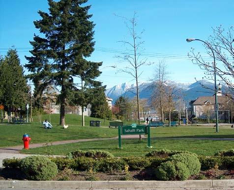
13 Mount Pleasant Community Plan Community Concern 3: the community supported retaining the Main St. view cone, protecting existing views, and restricting development of higher buildings along the east side of Main Street. Staff suggest that further work be done on this issue at the rezoning stage: clarification of the dimensions of the view cone is needed, along with a careful examination of potential development in and around the view cone, in consultation with the broader community. The rezoning process must demonstrate how altering the view cone will improve site development and street character, and provide public benefits, without compromising important public views. c. Broadway West Reflect the outdoor character of the shopping area with additional bike facilities, and pursue a gradient of retail stores from Cambie St. (with its big box stores) to Main St. (with its small-scale shops). Increase permitted residential (with commercial space) along the north side of Broadway; heights of buildings should generally be 6 storeys (allowing for some midrise buildings beyond 6 storeys); and consider lot consolidation across the lane in blocks with short lots (i.e., north side of Broadway between Yukon St. and Quebec St.). Consider creating a significant pedestrian connection leading to Jonathan Rogers Park, with commercial storefronts facing open space, potentially consolidating the block and reorganizing the lane. d. Broadway East Revitalize Broadway East, attracting a mix of business and residential development, including additional artist space. Increase permitted residential (with commercial space) along the north side of Broadway with additional density and height to increase private investment in the Broadway East shopping area, and contribute to public benefits. Allow up to 6 storeys for mixed-use developments along the north side of Broadway between Prince Edward and Prince Albert Streets; allow buildings above 6 storeys only on the north side of Broadway at the east and west ends of the shopping area, between Prince Edward St. and Guelph St., and between Fraser St. and Prince Albert St. Community Concern 4: the community expressed concerns about allowing buildings above 6 storeys on the north side of Broadway at the east and west ends of the shopping area, between Prince Edward St. and Guelph St., and between Fraser St. and Prince Albert St. The concern is in recognition of potential impacts on views and overshadowing of adjacent areas, along with changes to the character of the street. Further work will be required on this issue when a revitalization strategy is drafted for Broadway East. The strategy must assess how the additional height serves to trigger redevelopment, and lead to improvements in site development and street character, and provisions of public benefits, without compromising urban design considerations (including overshadowing), and important public views. Investigate creating Fraser Square on north side of Fraser St. at Broadway by closing off (or partially closing off ) Fraser St. in order to create a community stage incorporating sitting areas, meeting places, and provide a view of (and greater connection to) Sahalli Park. Provide a wide range of cultural programming possibilities, especially for youth (e.g., producing and selling local art, community stage).
14 Mount Pleasant Community Plan Community Concern 5: the community expressed concerns about closing off the north arm of Fraser St. at Broadway, because of the impacts on local traffic, and the prospect of the resulting open space being unsafe and unavailable for local residents (subject to use by drug users and sex trade workers). Further work will be required on this issue to review local traffic implications, design, and funding for any partial or full street closing, and to address the proposed change in light of the revitalization strategy being drafted for Broadway East. Connecting Key Questions to Plan Principles, Plans, and Policies By way of example, this table illustrates how the content of the Plan answers one of the key questions: Key Question How can Mount Pleasant become Vancouver s greenest, most sustainable neighbourhood? Overarching Principles More housing and housing variety, retain more affordable housing Development and services to meet local needs Large site development near transit Creative development of open space Laneway development Pathways between areas Maintaining population diversity Policies to Address Key Issues - Partnerships with senior levels of gov t - Standards of building maintenance - Sustainability of new housing - Hub at Broadway and Clark - More opportunities for food growing - Support services for the homeless - Assess City policy respecting art and culture - Increase recycling and composting - Rapid transit to UBC - Extension of streetcar network up Main - Create n hood square - Laneways - Pedestrian and cyclist corridors - Cleaner lanes - Greater pedestrian and cyclist use - More arts and culture space - Separated pathways for walking and biking - Linkages north to False Creek Flats and Strathcona - Intergenerational support - Space for seniors programming - Immigrant support Shopping Sub-Area Plans and Policies - More housing on large sites, and along Main 2 nd to 7 th, Main 12 th to 16 th, Broadway West and East - Provide mix of residential, office, and retail space - Small frontages, small business - Create Cultural District - Kingsgate Mall - Rize-Alliance site - IGA site - Improve site development on large sites with open space - Use space intended for Kingsway Connector - Watson Street improvements - Connections to 10 th Ave. Bike Route - Add bike infrastructure - Pedestrian connection to Jonathan Rogers Park - Add mix of housing (types, tenures) reflecting diversity of population
15 Mount Pleasant Community Plan Social Component: Development and Implementation of a Community Action Agenda The Mount Pleasant Community Plan offered the residents of Mount Pleasant a unique opportunity to address pressing social issues at the local level while at the same time planning for the longer term. This opportunity, known as the social component, was introduced for the first time as a pilot program to help enhance and integrate traditional land use practices and principles with current social development and capacity building techniques. This integration was seen as a new initiative of doing while planning. Community Action Agenda The social component was formalized in a Council report early on in the Community Plan process to give staff and the community the opportunity to move quickly with implementation. The social component, referred to as the Community Action Agenda (CAA), was approved by Council on February 14, The CAA was developed based on feedback received from the broader community with over 1,000 comments, ideas, and suggestions received on a Feedback Form distributed at community events and community group meetings. Four key social issues were identified: 1. Support for the Vulnerable (40% of respondents) 2. Safety and security (25% of respondents) 3. Open alcohol, drug and sex trade (25% of respondents) 4. Homelessness (10% of respondents) Each social issue was also linked to 3 to 5 objectives outlining what the community wished to achieve in relation to these issues. Over 50 separate actions and projects were also suggested by the broader community to pursue these objectives. After adoption of the CAA, the community pursued these actions and projects based on resources needed for implementation; in some cases new actions/projects were added by the community during the implementation process. Social Coordinating Group To implement the CAA, staff and the community formed a local community-based committee called the Social Coordinating Group (SCG). The SCG s mandate as approved by Council was to implement up to 3 to 4 projects during the planning process. Over 10 projects and actions were eventually completed between February, 2008 and December, 2009 (2 more projects have been completed since December, 2009, with an additional 3 projects still being carried out). The SCG was comprised of a membership of over 150 individuals and groups made up of businesses, residents (including homeless people), religious organizations, community groups, and service providers. The SCG established working groups to resource and launch the actions/projects referred to above. The SCG sought to build local partnerships and networks to advance priority actions/projects through in-kind support, donations, volunteerism, and limited grant writing. Wherever possible, the SCG coordinated its efforts in alignment with existing civic initiatives including Keep Vancouver Spectacular, the Homeless Action Plan, and Crime Free Multi- Housing programs. The SCG also supported locally based initiatives through the Collingwood
16 Mount Pleasant Community Plan Community Policing Office and Mount Pleasant Neighbourhood House through programs like Block Watch and Harvest Fest. Outcomes and Outputs There are several key findings from the CAA process, the most notable ones including: The 12 projects completed by the SCG and working group members addressed the key issues identified in the CAA, and were of a tangible benefit for Mount Pleasant s at-risk groups. Projects included Single Mom's Clothing Swap, Homeless People Interviews, a Homeless Information Brochure, a Neighbourhood Survey on Safety and Security, a Neighbourhood Resource Directory, and Cycle Back Bike Training Repair Shop. Cycle Back, sponsored in part by the Olympic Sustainability Fund, established a bike repair shop to help former homeless people living in Mount Pleasant cycle back into society with technical certified training and employment placement. A three-way partnership formed with UBC, the SCG and the City to conduct research into best practices to help inform future community-based committees based on findings from four different Vancouver models. Findings from the research will help inform future improvements to the CAA process, and at the time helped to assist the SCG to develop a transitional plan for As of January 2010, the SCG has been operating on its own without any civic support while at the same time continuing to advance the mandate of the CAA. Residents were able to bring their skills to the process and to learn new ones; that even though many of them had not participated on a community-based committee before that they are now more likely to volunteer in the future based on their positive experience with the SCG. Increased knowledge, awareness, and familiarity of the issues and what could be done about them were also important outcomes. SCG members also participated in other Community Plan workshops and meetings, providing both energy and a social perspective on the land use and transportation questions being addressed through the larger public process. Plan Implementation Avenues to Plan Implementation Implementing the Mount Pleasant Community Plan will involve a combination of efforts stemming from a number of different initiatives: a. Site-Specific rezoning involving applications from landowners/developers to change the designation of land in accordance with Community Plan principles and policies. Currently a rezoning application has been received by Rize Alliance Properties for the site bordered by Broadway, Kingsway, 10 th Ave., and Watson St. The rezoning process with public engagement should explore how to reach an optimal balance of public benefits, site improvements, and urban design objectives with higher densities in low-, medium-, and, on selected sites, highrise forms of development. b. On-Going City Programs and Projects involving the application of staff resources and/or capital funding already dedicated to address key City issues and objectives, like the provision
17 Mount Pleasant Community Plan of bike facilities and routes, park improvements, and traffic calming. During the Community Plan process, heritage staff, working with consultants, drafted a Mount Pleasant Heritage Context Statement which can be used in the Heritage Register Upgrade. Combining efforts to achieve outcomes that accomplish a variety of City and neighbourhood goals can also be pursued. An example of such an effort could involve the installation of traffic calming devices which could enable the creation of pockets of green space and/or the provision of bike parking facilities. Another example would involve the implementation of the City s Cultural Plan and Cultural Facilities Priorities Plan, which would further the Community Plan s directions regarding arts and culture. c. New Programs and Projects involving requests for new resources to implement the plan in cases where no resources are currently in place. Staff will report back to Council in instances where this support will be required in order to implement Mount Pleasant s plans and policies (e.g., City-initiated rezonings along Main 2 nd to 7 th Ave., Main 12 th to 16 th Ave., and East Broadway north side Prince Edward St. to Prince Albert St.). In addition, the emerging Homelessness and Housing Strategy is investigating creative approaches to achieving affordable housing (market and non-market) which may inform future rezoning processes. Steps to Begin Community Plan Implementation Staff will begin the process of plan implementation by taking the following steps: a. Revitalization Strategy for Broadway East A revitalization strategy will be devised by staff, working with the community, to address the issues identified in the community plan respecting Broadway East. The strategy will have physical, economic, and social dimensions for example, public realm improvements can be brought about through redevelopment, which also can deliver new housing and services to the area, which, in turn, can create a safer environment for local businesses and residents. It will also recognize the economic and development history in deciding on an appropriate response. The strategy will determine the conditions and priorities needed to set revitalization in motion on Broadway East. b. Public Benefits and Infrastructure Strategy A Public Benefits and Infrastructure Strategy will be devised for Mount Pleasant to enable the delivery of multiple public benefits identified in the community plan. This Strategy will identify the capital costs for new public amenities and facilities requested in the community plan (e.g., childcare, parks, engineering infrastructure, cultural spaces including artist live/work, heritage retention, and affordable housing), potential revenue expected from new development and other sources (e.g., DCLs, CACs, Capital Plan), and the allocation of that revenue to support the new amenities and facilities. The strategy will also seek to ensure that new development on both City and private land pays a fair share towards public benefits and infrastructure needed to meet demands created by the new population. c. Public Realm Plan A Public Realm Plan will be drafted to bring about the public realm improvements identified in the community plan. In general, the public realm plan should address issues of connectivity across Mount Pleasant (e.g., with pathways and bikeways), street vibrancy, provision and
18 Mount Pleasant Community Plan design of public spaces (including public art), and sustainability (e.g., rainwater management, wildlife habitat, and other ecological considerations). A key consideration will be approaches to daylighting and marking Mount Pleasant s streams. In light of the Plan s support for universal design, the Public Realm Plan should respond to the approach taken by the Mount Pleasant Wellness Walkway to enhance the urban environment for all pedestrians. d. Public Engagement Review The overarching goal of this review is to improve civic decision-making, addressing issues of representativeness, diversity, trust, and creativity in neighbourhood decision-making, while building community capacity to solve problems. It will involve an investigation into creating a governance structure and process mechanism to engage representatives of the Mount Pleasant community, design professionals, and the City to collaborate on design solutions and implementation strategies for the Mount Pleasant Community Plan. As a first step, various models and best practices used in other neighbourhoods and municipalities will be reviewed. This would be followed by further dialogue with community stakeholders to jointly determine the best approach to adopt in Mount Pleasant. This review can complement the City s own on-going review of public engagement practices. Economic Viability of Development Options The Plan sets out policies to encourage development on large sites, and along some commercial strips, in order to improve site development, achieve public benefits, and provide more housing, while addressing urban design considerations. On the large sites, arriving at a final design including density and height will involve a rezoning process and community dialogue; no density and height limits are therefore prescribed by the Plan. Along some of the commercial strips (i.e., Broadway East, Main 12 th to 16 th Ave., and Main 2 nd to 7 th Ave), a 6-storey built form is supported with greater heights possible in certain locations on Broadway East and Main 2 nd to 7 th Ave., depending on the considerations cited above for large sites. The 6-storey building form is an emerging building type in Vancouver, in part because of changes to the Vancouver Building By-law regarding maximum heights for wood frame construction. Examples of this form of development have been proposed for and/or built along Cambie Street, Kingsway, and West Broadway. The viability of the 6-storey built form and opportunities to build higher at certain locations will be further examined during Plan implementation. Broadway East will be the subject of a revitalization strategy, and Main 2 nd to 7 th will undergo a rezoning process. FINANCIAL IMPLICATIONS There are no financial implications stemming from this Council report. Initial steps in implementation will be funded through existing departmental resources. Additional resources required to implement the community plan will be addressed in separate Council reports as necessary, in concert with the Public Benefits and Infrastructure Strategy. PERSONNEL IMPLICATIONS There are no personnel implications.
19 Mount Pleasant Community Plan ENVIRONMENTAL IMPLICATIONS The Plan is expected to have positive environmental implications as a result of linking mixeduse development opportunities on key sites along Main, Kingsway, and Broadway to current and potential transit services. Other policies which contribute to a better environment include improvements for walking, biking, and taking transit in Mount Pleasant, the development of laneways in the commercial areas, and introducing more open space through creative means like pocket and linear parks. SOCIAL IMPLICATIONS The Plan seeks to support the diversity of people living in Mount Pleasant with a balanced approach to development: new development is encouraged in areas in need of revitalization and near transit hubs, while other areas seek improvements to public realm and retention of existing residential and commercial development. The Plan seeks housing and services to meet local needs and measures to best integrate the at-risk population into the neighbourhood. The Plan also supports collaboration between the City, developers, and the community on Plan implementation; this can result in community capacity building to address current and future issues in Mount Pleasant. CONCLUSION The attached Mount Pleasant Community Plan has been prepared following a planning process involving City staff and Mount Pleasant residents, property owners, and business people. Adoption of the Community Plan will guide future plans, policies, actions, and other initiatives in Mount Pleasant. Plan implementation will follow the initial steps involving a strategy for revitalizing Broadway East, the development of a Public Benefits and Infrastructure Strategy and Public Realm Plan for all of Mount Pleasant, and an investigation of public engagement alternatives for implementing the Mount Pleasant Community Plan, in accordance with Community Plan Directions and in consultation with the local community. * * * * *


20 1 of 33 Mount Pleasant Community Plan
21 2 of 33 Contents 1.0 Introduction Study Area Planning Process Plan Context: Distinctive Mount Pleasant Mount Pleasant Community Plan 8 Overarching Principles 3.1 Housing and Population Mix Economic Development and Revitalization Built Form and Character Large Site Development Parks and Public Realm Laneways Transportation Heritage Culture Community Services and Development Public Engagement Shopping Sub-Area Plans and Policies Uptown Shopping Area (i) Rize Alliance Development site (ii) Kingsgate Mall (iii) IGA Site Main 2nd to 7th Broadway West Broadway East Plan Implementation Avenues to Plan Implementation Steps to Begin Community Plan Implementation Additional Considerations When Implementing 32 the Community Plan 4.0 Policies to Address Key Issues Housing (i) Additional Housing Opportunities (ii) Non-market Housing (iii) Building Maintenance Character Parks and Green Space (i) Adding Open Space (ii) Park Design and Services Laneways Services (i) Homelessness (ii) Garbage and Recycling Safety Walking, Biking, and Parking Transit (i) Great Northern Way Campus Transit Station Heritage Culture 22
22 3 of Introduction Council selected Mount Pleasant as the first of several higher density communities with older, out-of-date plans to undertake a new community planning initiative. The Mount Pleasant Community Plan was integrated with many City initiatives, including Greenest City, the Homeless Action Plan, the Rental Housing Study, the Metro Core Jobs and Economy Study, Vancouver s Transportation Plan and City Plan, the UBC Rapid Transit Line, the Social Sustainability Policy, the Heritage Register Upgrade Program, and the City of Vancouver Cultural Plan and Cultural Facilities Priorities Plan. Alongside these initiatives were a set of Council priorities homelessness and affordable housing; building strong, safe, and inclusive communities; environment and sustainability; and creative capital and a growing economy which provided further guidance to the planning process. Key planning process principles involved balancing the rights and uniqueness of the community with its responsibility as part of the City and Region, and that new plans and ensuring policies strive to be consistent with city-wide plans, policies, and initiatives. In recognition of this principle, the Mount Pleasant Community Plan has endeavored to respond to the following questions: What is distinctive and highly valued about Mount Pleasant as a neighbourhood? identifying its assets and strengths and how they might be nurtured How can Mount Pleasant become Vancouver s greenest, most sustainable neighbourhood? promoting a complete community with a mix of housing types, jobs, schools, daycares, shopping, and recreational opportunities increasing density close to public transit hubs, employment centres, and amenities such as shopping streets providing additional traffic calming measures, space for pedestrians, connections to greenways and bikeways, and interesting streetscapes 3 funding opportunities to further urban agriculture, expanding greenways, improving waste management, and promoting green jobs How should higher density development be incorporated into Mount Pleasant? providing high quality, attractive, more energy efficient, and affordable housing which respects neighbourhood character and lowers the carbon footprint creating more opportunities for the development of subsidized and supported housing throughout the City providing opportunities for both market and non-market housing development, making available tenures that are more affordable, and preserving, replacing, and expanding Mount Pleasant s stock of rental housing How can Mount Pleasant address the needs of homeless people? finding additional opportunities to provide its share of housing for the homeless delivering support services, projects, and other initiatives to help the homeless How should we strengthen Mount Pleasant s neighbourhood centres and shopping areas? adding professional and commercial services (including office), increasing the variety and affordability of housing, and promoting urban amenity and sense of place promoting the intersection of Broadway and Main as a high-quality pedestrian, transit, and commercial hub How can we support more walking, biking, and transit use in Mount Pleasant? calming traffic in neighbourhoods, while maintaining an efficient network for goods movement 3
23 4 of 33 improving safety at intersections (especially at 7th Ave and Main) anticipating location(s) for new RT stations, then planning appropriate residential and commercial development around those stations How can we preserve and promote Mount Pleasant s heritage? upgrading the Vancouver Heritage Register creating more effective planning tool for managing change to Mount Pleasant s historic places promoting heritage through history walking tours and other public space programs How can we promote arts and culture in Mount Pleasant? addressing the gaps, needs, and opportunities for the retention, renovation, restoration, and construction of facilities, spaces, and places for the creation, production, presentation, support and experience and enjoyment of cultural expression in all its forms How can Mount Pleasant become a socially sustainable community? building on its own resources, with resiliency to prevent and/or address problems in the future including supporting vulnerable people and promoting a safe community encouraging continuing relationships, networks, and norms that facilitate collective action to improve quality of life and to ensure that such improvements are sustainable The Mount Pleasant Community Plan responds to these questions with: Overarching Principles which set out the overall goals of the community plan the basis for future plans, policies, actions, and other initiatives; Policies Addressing Key Issues policies, actions, and other initiatives related to housing, transportation, heritage, character, safety, services, and culture; and 4 Shopping Sub-area Plans and Policies. This document concludes with a description of the processes needed to implement the Mount Pleasant Community Plan, including a set of initial steps involving: a strategy for revitalizing the area referred to as Broadway East; development of a public benefits strategy and public realm plan for all of Mount Pleasant; and an investigation of public engagement alternatives for implementing the Mount Pleasant Community Plan, in accordance with Community Plan Directions and in consultation with the local community. The policy context, together with Council priorities, will continue to evolve over the lifetime of the Mount Pleasant Community Plan, and thus new policies and priorities may come to inform and guide its implementation. In responding to the policy context especially in areas of mostly provincial or federal jurisdiction the community plan recognizes the need for partnerships, particularly the areas of housing, services, and regional transportation. Support from relevant federal and provincial ministries and agencies, regional health authorities, and TransLink would be preconditions for fully implementing community plan policy. Some community plan policies can be implemented more quickly, closely aligned with existing city policy, priorities, and programs (e.g., traffic calming, business improvement area assistance, park improvements, bikeways, and greenways). Other plan policy may take shape over many years, requiring the assembly of city resources and/or further co-operation with senior levels of government to pursue implementation. The community plan will help to set priorities and to direct funds to programs which achieve policy over time. 4
24 5 of 33 The community plan also provides the community with a framework for action and volunteer initiatives. Continued community involvement will be necessary to set priorities and provide leadership over the life of the community plan. Further discussion regarding plan implementation occurs in section 6.0 of this document. 1.1 Study Area The Mt. Pleasant local area is bounded by Cambie Street to the west, 16th Avenue to the south, Clark Drive to the east, and Great Northern Way/False Creek to the north. The Community Plan will focus on the area shown in Map 1. Southeast False Creek Mount Pleasant Industrial Area QUEBEC 2ND GREAT NORTHERN WAY Mount Pleasant Community Plan Area Administrative Boundary Land use policy and urban design in the remainder of the Mount Pleasant local area is, or will be, addressed through other initiatives: South East False Creek: the Olympic Athletes Village and the other lands north of 2nd Avenue will be guided by the recently adopted Official Development Plan; Cambie Street: Public realm improvements along Cambie Street within Mt. Pleasant will be constructed as part of the completion of the Canada Line project; land use and urban design issues will be dealt with through future station area planning. Additional planning for the Cambie Street commercial frontage, will be incorporated in future planning (e.g. Metro Core Jobs and Economy Study, and Fairview Community Planning); Mount Pleasant Industrial Area: Future land use of this area, generally bounded by Quebec Street, Broadway, Yukon Street and 2nd Avenue, will be addressed in the Metro Core Jobs and Economy Study; and Kingsway and Fraser Street: The small commercial node at Kingsway and Fraser Street will be combined with the larger commercial area on Kingsway and Fraser Street to the south of 16th Avenue in a future Neighbourhood Centre Planning program. CAMBIE YUKON Map 1 12TH MAIN KINGSWAY 16TH FRASER BROADWAY CLARK 1.2 Community Planning Process The Community Planning process consisted of three main steps, preceded by initial pre-launch preparation. These activities and steps are described below. Pre-launch/Organize Initially staff defined basic community information required for each step in the process. This included demographic, land use, housing stock, social conditions, traffic flows, heritage and neighbourhood character, economic characteristics and other technical information and analysis required to inform the program and participants. 5 5
. A Feedback Form seeking community input on priorities for action was developed.")


25 6 of 33 Step 1: Start-up and Getting in Touch This step included initial outreach to community groups, businesses, and service agencies; an initial newsletter; and recruitment of members for a Community Liaison Group (CLG). A Feedback Form seeking community input on priorities for action was developed. This was a starting point for community discussion and it helped shape the issues and opportunities addressed in the program. Two Community Plan Fairs were held as kick-off events to: increase community awareness of the program, publicize opportunities to participate, and help set priorities for subsequent program steps. Step 2: Workshops and Community Action Projects Shopping Area Plans and Policies for Key Themes The Shopping Area Plans involved concurrent work on the three existing shopping areas and for the light industrial/commercial area on Main Street from 2nd to 7th Avenues. The Key Themes explored in the planning process included Housing, Transportation, Safety and Services, Parks and Open space, Heritage and Character, and Culture. To produce these plans and policies, the process steps included: reviewing of existing issues and policy, and land use and transportation patterns in Mount Pleasant; discussing needs, challenges, and opportunities in a series of public workshops, open houses, focus groups, and other engagement vehicles; urban design analysis of built form options, including alternative land uses, public realm and public open space opportunities; and Community Action Agenda/Projects This part of the program focussed on taking coordinated action on pressing social issues. The main steps included: drafting a Community Action Agenda based on Feedback Form responses; forwarding the Community Action Agenda to Council for approval; forming a Social Coordinating Group (SCG) of key stakeholders; developing action plans for specific community projects; recruiting additional working group members to implement action projects/plans; implementing 12 projects to address 4 key social issues: homelessness; support for the vulnerable; open alcohol, drug, and sex trade; and community safety and security; and coordinating and monitoring project implementation. Step 3: Open Houses and Completing the Plan At this stage all the elements of Mount Pleasant s Community Plan were brought together for broad community validation and Council approval. The main steps included: a final broad public review of the draft Community Plan for both general and specific components of the Plan through a series of 5 Open Houses held across the community; modifying and refining the draft Plan based on feedback; and forwarding the draft Mount Pleasant Community Plan to Council for adoption. 6 6


26 7 of Plan Context: Distinctive Mount Pleasant Mount Pleasant has a number of geographical and historical features that the community wishes to acknowledge and respect as critical in the shaping of the Community Plan, and as contextual factors in development. Valued assets include: the topographical rise from the False Creek Flats up to 16th Avenue where a number of creeks once flowed, including the one which became known as Brewery Creek; the traditional Aboriginal pathways that led from fishing grounds to areas of settlement and cultivation; the multiple waves of later settlement of this part of the city by Europeans, Americans, Asians, and others who, for example: built housing and churches along the 10th Avenue skyline established the industrial heart of Vancouver with sawmills, metal fabricating plants, coal yards, breweries and other enterprises established the city s first small business, and one of the province s first Business Improvement Associations positioned Mount Pleasant as the first downtown of Vancouver in the early years of the 20th century (with 9th Avenue then renamed Broadway and Westminster Avenue becoming Kingsway), resulting in significant numbers of heritage buildings and features built a cycling track; established streetcar lines and created an artists enclave with multiple performance sites. the community becoming home to a greatly diverse population, including newcomers from all over Canada and the world; the reputation of the area as a hub of creative activities and cultural and artistic expression; the vibrant mix of small businesses in this community; four distinctive shopping quarters within Mount Pleasant, fanning out from the community nexus at Main Street and Broadway Avenue and the circulation links between these four quarters; a large inventory of relatively affordable housing, including rental and social housing; and the neighbourhood s unique location in straddling the west and east sides of the City. 7 7

27 8 of Mount Pleasant Community Plan Overarching Principles The Mount Pleasant Community Plan establishes a number of overarching principles which set out the overall goals of the community plan. These principles are intended to inform all future planning and development programs, projects, and other initiatives in Mount Pleasant. 3.1 Housing and Population Mix Diversity in housing, land uses, businesses and services Ensure livability for the existing types and sizes of families and households by encouraging the development of housing that addresses a wide range of affordable housing needs including rental, co-ops, supported housing, and artist live-work housing while seeking to provide the services and facilities that those families and households need. Serve a highly diverse population mix with a mix of unit sizes and housing types, a mix of land uses across the neighbourhood and a mix of uses within many individual buildings, a mix of architectural styles, a mix of tenure arrangements (fee-simple, strata, co-op, co-housing, rental, subsidized housing, possibly land trust), and a mix of businesses and community services. 3.2 Economic Development and Revitalization Four distinctive quarters, each with opportunities for revitalization and new development In treating Mount Pleasant as a hilltown that uniquely straddles the west and east sides of the city of Vancouver, and as a neighbourhood with a single heart (the triangle block formed at the intersection of Broadway, Main, and Kingsway), also 8 recognize four distinct shopping areas in Mount Pleasant. Each of these distinct quarters needs an anchor business or multi-service centre, and a mix of other businesses and services. Treat each of the four separate shopping areas as having a distinct identity, with each of these village nodes serving the whole of Mount Pleasant in different but complementary ways. Routes between these shopping areas are as important as circulation within each of them. The community has identified needs that are specific to each sub-area, and calls on the City to develop strategy (including added density and height) to attract and encourage development that will respond to these needs, revitalize pockets identified as dead zones by residents in Mount Pleasant, and further enhance the vibrancy of Mount Pleasant. Economic development strategy Sustain and further encourage a wide variety of independent businesses and professional services that respond to the local needs identified by the community, including niche businesses that will meet the needs of specific communities (for instance, different ethnic groups) within the larger neighbourhood community. Encourage the incubation of new businesses and other creative economy enterprises. Develop without big box stores. Broadway East Recognize Broadway East as the highest priority for revitalization and new development, community programming, and land uses designed with the aim of sustaining crime reduction. 8

. As a hill town populated by wave after wave of new settlers, each bringing distinctive strengths (e.")
28 9 of Built Form and Character Hilltown identity Conceive of Mount Pleasant as a distinctive hilltown area whose centre is a high-attraction zone for both residents and city visitors. Recognize that its slopes are natural form-makers on which a low profile for residential and commercial properties helps keep the sense of hill intact. Also recognize the historical importance of the hilltown identity, reflecting the Victorian-era reference to the location at Main and 8th Ave. as Church Hill (where a number of churches were located and made prominent by their church spires). As a hill town populated by wave after wave of new settlers, each bringing distinctive strengths (e.g., new industry, jazz history, etc.), this neighbourhood warrants ongoing promotion as a heritage area of the city. Seek to distinguish new development in Mount Pleasant from predominant forms of development in other parts of the City in ways that respond to the unique social, economic, and physical qualities of the neighbourhood. Welcome future heritage too Keep finding a good way for contemporary design to also fit into the neighbourhood. As an appreciated contrast / complement to preserved heritage, invite and support architectural innovation that creates new legacies (individual sites and/or streetscapes) of which the community is proud. Recognize the need for quality design in new buildings, and the prospect of building landmark buildings on important and highly visible sites. Predominantly low to mid-rise massing Honour the local preference for a high-low massing rhythm across the hill town, but with modest height as the norm: mostly low to mid-rise buildings, high rises only on selected sites. Emphasize infill opportunities in achieving density objectives. Vibrant streetscapes Maintain and encourage a safe and active street life by, for example, wrapping street landscaping and small commercial activities around street corners, providing space for outdoor seating for cafes and restaurants, greening front entryways with container plantings and window boxes, ensuring the presence of eyes on the street from windows and entryways, and ensuring service/retail continuity in commercial areas. With mid- to high-rise buildings, pay particular attention to good design at the street level. There needs to be a rhythm of building and store frontages; these frontages need to be varied and visually engaging to passers-by. Watson Street Develop Watson Street as a special site, perceived as unique in history, character and use (similar to the Mole Hill precedent in Vancouver s West End neighbourhood) and explore improvements for pedestrians and cyclists, especially through redevelopment. 3.4 Large Site Development As a general guideline for the whole neighbourhood, the community supports greater use of infill opportunities over high-rise development but the Mount Pleasant community also sees opportunities for some 9 9
 and important public benefits (including contributions to")

, and other public benefit considerations as noted above. Distribute the height/bulk in relation to the character of adjacent streets (e.g., more height along Broadway, reduced height along 10th Avenue and Prince Edward, larger scale on Kingsway vs.")
29 10 of 33 high-rise as well as mid-rise development in some specific locations, such as for large sites (i.e. Kingsgate Mall, IGA site, and Broadway, Kingsway, Watson Street, and 10th Avenue site). For the purposes of achieving more appropriate site development (meaning more open space, less paving, better connections to the street) and important public benefits (including contributions to heritage retention, new cultural amenities, affordable housing, childcare, flexible gathering spaces, improved pedestrian environment, provision of cycling routes, streetcar amenities, green space), pursue additional height and density in select locations. For these sites, participants in the planning process considered and supported a variety of built form options. Any additional height and density would be contingent on further urban design analysis, including shadowing, view impacts, look and feel of the area, permeability of the site (the ability of people to see and walk through the site), and other public benefit considerations as noted above. Distribute the height/bulk in relation to the character of adjacent streets (e.g., more height along Broadway, reduced height along 10th Avenue and Prince Edward, larger scale on Kingsway vs. smaller scale along Main Street). 3.5 Parks and Public Realm Distributed green space Address the constraints on larger park development and the strong desire of this community for more green space by increasing vertical gardens, linear parks (laneway edges, adaptive street use), pocket parks, and courtyards, other patios and rooftop terraces with public access, and as an outcome of redevelopment on any large site. 10 Public realm Increase and promote public realm assets and appreciation of them especially green space and opportunities for farmer s markets and other outdoor events/ celebrations by preserving and adapting City owned lands to those purposes, and setting conditions on development. 3.6 Laneways Laneways Encourage laneways in suitable locations as a prized feature of Mount Pleasant, activating commercial lanes to make them places to walk, live, and work, while still serving commercial loading/unloading and waste management routes. Using space outside the lane right-of-way, activate the laneways in all these respects: animating lanes by encouraging commercial activity on the lane e.g., presentation space/studio work space for artists/artisan shops, outdoor seating for cafes by greening the lane - with PROJECTS In PLACE s o c i e t y vision drawing by TRAVIS MARTIN 10

; using laneway margins where possible to support urban agriculture; and")


30 11 of 33 trees, landscaping, public art installations (permanent and temporary), and murals and by creating small courtyard spaces or mini-plazas (as refuge spots or places to hold special events); providing a second face of Mount Pleasant with expanded opportunities to position architecturally innovative new development along these routes, strengthening the vitality of Mount Pleasant as a business district by promoting dual-entrance options, laneway-facing studios or other small businesses, temporary art installations, and other back route enhancements; reinforcing Mount Pleasant s identity as a creative community by increasing the amount of public art in the lanes (permanent and/or temporary installations); using laneway margins where possible to support urban agriculture; and recognizing Mount Pleasant as a neighbourhood where laneways can be demonstrated and lessons can be learned for application in other parts of the City. 3.7 Transportation Walking, cycling and public transit Maintain priority support for walking, cycling and use of public transit as the preferred modes of travel, and mitigate the impacts of traffic and parking on the livability of Mount Pleasant. 11 Network of routes Restore/create routes for pedestrians, bicycles, skateboards, rollerblades, and wheelchair/ scooters as a high-priority amenity in this neighbourhood. Keep pedestrian and cyclist routes relatively car-free, link the four distinct shopping areas, connect across busy arterials, connect to transit, connect historic sites, and create a continuous green circuit throughout the neighbourhood. 3.8 Heritage Preserve heritage Recognize and preserve all heritage buildings. Also find a variety of ways of acknowledging other kinds of heritage throughout the community, including: historic waterways; heritage trees and other aspects of the natural history; settlement and social history; streetscapes as well as individual building sites; industrial history; transportation history; and cultural history (including performance sites). Ensure that heritage preservation includes the development (programming and promotion) of heritage activities that celebrate this rich settlement, cultural and industrial history. Recognize and celebrate the triangle block as representing the historic heart of this community. 11

31 12 of 33 Neighbourhood founders acknowledgement Respect and honour the history, traditions and current presence of Aboriginal peoples and sites; investigate opportunities to deliver tangible support for Aboriginal projects and initiatives, including locations and spaces to mark cultural observances. 3.9 Culture Strong focus on a creative community Retain existing and develop new gathering, creation, production, presentations, and support spaces (with an emphasis on flexible use) for cultural, social and economic activities, which contribute to the neighbourhood character, reflect its wide-ranging creativity, and also mirror its multicultural identity. Recognize that Mount Pleasant is a valuable economic development asset to the whole of Vancouver because of its vibrant and creative community which attracts visitors and residents Community Services and Development Plan for the retention and enhancement of community assets Build on the past and current strengths of Mount Pleasant, recognizing Mount Pleasant as a resilient and vibrant community already. With new development, keep the neighbourhood context always in mind. Also consider the residents themselves (along with service providers and business operators in Mount Pleasant) as an important asset in the development process. 12 Social cohesion focus In all aspects of community planning i.e., physical building, development of open space, service provision, and community programming social cohesion is of utmost importance to this community. The Mount Pleasant community wants to: welcome, engage and integrate newcomers; maintain diversity in its population; provide support to residents of all ages through the types of businesses, services, and recreational and volunteer opportunities available in the community; proactively model best practices to reduce the risk of crime and social disturbance and to heighten citizen engagement in neighbourhood stability, health and resilience. Fairness and equity in service provision city-wide In the planning and creation of more services for the community (including recreational, health and cultural services), ensure the application of fairness and equity principles, promoting community safety and enhancing opportunities for people to mix with one another in a range of recreational, social and cultural activities across the city. Integration of at-risk individuals and families Recognizing Mount Pleasant as a welcoming and inclusive community, ensure that social housing is provided in this neighbourhood with a concurrent increase in support services for at-risk individuals/families who need that housing, including engagement programs for those residents. Integrated community planning must be given precedence over simply meeting housing needs. Adhering to fairness and equity principles includes distribution of social housing and services for at-risk groups (people who are homeless, have addictions, live with multiple disorders, are chronically unemployed, and/or live with other high-risk conditions) across all neighbourhoods of Vancouver, not concentrating them in eastside neighbourhoods, or any one (or a few) neighbourhoods. Fairness and equity, in practice, also mean not concentrating housing or services for at-risk groups in one sub-area of a given neighbourhood and thereby creating ghettoes. 12
 accessible by persons of all ages and abilities/disabilities. 3.")
32 13 of 33 Inclusivity commitment Within Mount Pleasant, promote universal design principles and apply them to the greatest extent possible, to make all spaces (whether residential, commercial or public realm) accessible by persons of all ages and abilities/disabilities Public Engagement Build community capacity Build or enhance community capacity throughout the planning and development processes, ensuring that the process seeks common ground and reflects the interests of the broad community. and related process mechanisms will serve to steward the vision of preserving heritage, sustaining a vibrant and creative place, welcoming architectural innovation, and building fine new legacies here. The first step in creating the appropriate mechanism(s) will be investigation by City planners into the various models and best practices used in other neighbourhoods and municipalities to achieve similar goals, followed by a report and then further dialogue with community stakeholders to jointly determine the best approach to adopt in Mount Pleasant. Co-design approach to community development Create mechanisms both a governance structure and process mechanisms that will engage representatives of the Mount Pleasant community, design professionals, and the City together, as an ongoing means of (a) identifying new local needs as well as persistent community needs, and (b) collaboratively ensuring that design solutions and implementation strategies will meet those needs in a way that strengthens and enhances the Mount Pleasant community, while upholding the principles and policies of the Mount Pleasant Community Plan. Whether in the form of a Neighbourhood Design Panel or Area Council or other structure, the commitment must be integrated into community planning. Physical design challenges and solutions and social needs must be addressed together to ensure a strong community. This body 13 13


.")

33 14 of Policies to Address Key Issues These policies are largely directed at the City of Vancouver as the most significant policy-maker, regulator, and sometimes funder of projects related to the key issues, and are more focussed (i.e., by location, action, or actor) than the overarching principles discussed above. However, as discussed above, senior levels of government and their agencies have a role to play in the implementation of some of these policies, respecting housing, services, and transportation. 4.1 Housing Provide more housing and more affordable housing in Mount Pleasant for low to middle income households, especially for families, seniors, new immigrants, and aboriginal people. Seek opportunities to build a greater range of housing types in Mount Pleasant, from SRO s to row housing, to apartments, to house youth, large and extended families, and seniors (to age in place). Seek to reduce barriers to the construction of new market rental housing, and provide more market rental housing in Mount Pleasant, by: having the City provide more land for rental housing; addressing rental restrictions placed on some strata units by Strata Councils; and encouraging retention of rental buildings. Apply principles of universal design to buildings and environments to make them usable and effective for everyone. Seek opportunities and act to reduce parking requirements for housing in order to reduce construction costs (thus reducing housing costs), and to free-up space for alternative uses (e.g., garden space). 4.1 (i) Additional Housing Opportunities Allow increased housing density in Mount Pleasant near transit hubs, commercial centres, parks, along arterial streets, and/or streets with linear parks, and with adequate provision or leading to the provision of public services like schools, parks, childcare, community centres, and transit
; fix the existing infill housing policy to enable infill housing to be built on most lots (e.g., 33 foot lots).")
34 15 of 33 Encourage housing on lanes in Mount Pleasant both infill and Laneway Housing - to increase number of units, to increase laneway animation, to provide mortgage-helpers, and to improve housing affordability (with a smaller dwelling unit); fix the existing infill housing policy to enable infill housing to be built on most lots (e.g., 33 foot lots). Investigate creating a walkable, shopping and residential hub at Broadway and Clark, encouraging uses like local coffee shops, minigardens, grocery stores, restaurants, music venues, galleries. 4.1 (ii) Non-market Housing The City should seek partnerships with senior levels of government to provide more affordable housing by providing stable funding for non-market housing, grant support for building and maintaining more affordable housing, and tax incentives for building rental housing. Support the distribution of non-market housing throughout the community and the City to retain neighbourhood diversity of population and services. Undertake more research by City, shared with the public, on best practices of integrating marginalized at-risk groups into the neighbourhood. 15 Help sustain and promote more co-ops and co-housing. Benefits include long-term, secure housing, and contributions to social/ economic/family diversity. Support housing for the homeless and others with housing needs, by: retaining rental suites through restrictions on redevelopment; providing new non-market housing as part of any large site rezoning and redevelopment; and providing further incentives for the retention of heritage buildings. Increase affordable housing along Broadway between Main and Clark. 4.1 (iii) Building Maintenance Explore strengthening standards and enforcement of standards to ensure that landlords of low rent units and multi-family buildings are maintaining their buildings, without evicting tenants and significantly increasing rents. Consider creating incentives for all residents to maintain their buildings, including the elderly, those on fixed-incomes, or suffering from a lack of health. 4.2 Character Investigate opportunities to increase the quality of new housing being built (e.g., better scale, materials, detailing, and craftsmanship) Explore opportunities to further sustainability and energy efficiency in design including: retaining heritage buildings with green adaptions (e.g., introducing roof gardens, solar panels) applying the City s latest environmental standards to all new development (e.g., LEED or other standards more responsive to local conditions) reusing building materials obtained from demolished buildings. 15
.")
.")

. Improve open space at Mt.")
35 16 of 33 Investigate opportunities to increase the variety in design of new housing (e.g., discourage cookie-cutter design ) and innovation in building design (e.g., discourage replications of heritage-style architecture or faux heritage ). Explore impacts of reducing the height and bulk of new duplexes (including likely impacts on unit size, property values, and carbon footprint). Explore opportunities to allow alternative types of building construction (e.g., cob or straw bale construction) 4.3 Parks and Green Space Encourage community involvement in the programming and maintenance of parks (increasing their use, making parks safer). Expand urban food growing/education in Mount Pleasant by proactive policy, active program support, community engagement, and proactive use of underutilized space (e.g., personal garden sharing, cultivating bees, vertical gardens). Encourage green roofs for amenity, recreation, and food growing. Explore opportunities for daylighting Mount Pleasant s streams, and creatively and substantially marking the historical course of those streams, encouraging people to think about the neighbourhood as involving a complex ecology. Encourage the greening of back lanes in residential areas (e.g., more Country Lanes ). Improve open space at Mt. Pleasant Elementary and turn area into special gathering place with hard and soft landscaping (i) Adding Open Space Pursue creative ways to add park space in Mount Pleasant, especially in areas without parks nearby, including purchasing corner parks, reusing streets and parking lots for multiple purposes (e.g., slowing traffic and enhancing pedestrian use of the street), setting back buildings (to create small green spaces), and encouraging donations of green space. Create one new central neighbourhood square (with covered area) for events like farmers markets, festivals, parties, and gatherings. 4.3 (ii) Park Design and Services Express the welcoming spirit of Mount Pleasant in outdoor space design by embracing a diverse population including youth, families, different income groups, and aboriginal people. Examine opportunities to improve Mount Pleasant s parks, by: adding enhanced lighted recreational space (e.g., for basketball) continuing to make parks accessible for all users (i.e., ease of travel to and within parks) adding additional play equipment, and enclosed and covered play space for children (especially younger ones) providing free Wi-Fi connections, with easy universal code, for way-finding, park or heritage tours incorporating exercise equipment for adults and seniors Provide more space for arts and culture in parks, including rotating art exhibits, public art installations, musical/theatrical shows, and festivals. 16


. 4.")
36 17 of 33 Provide more public washrooms in Mount Pleasant s parks, and seek partners to accomplish this (e.g., developers and local businesses). Examine opportunities to improve Mount Pleasant s parks by adding a skateboard and bike park and an enclosed off-leash area to Jonathan Rogers Park and Guelph Park. Explore ways to increase local residents use of City Hall Park (e.g., playgrounds, holding community events). Make improvements to North China Creek Park, including providing an all-season pathways/running/biking surface, a community garden, enhanced children s play area, integration with Central Valley greenway, and highlighting the park s significance in the history of Vancouver. Make improvements to South China Creek Park, including addressing safety and cleanliness issues, and providing more play equipment for families and youth (e.g., basketball hoops). 4.4 Laneways Develop a Laneway Strategy as part of the Public Realm Plan for Mount Pleasant, and use Mount Pleasant as a pilot area for testing suitable locations for laneway animation, for the benefit of the entire City. Encourage cleaner lanes and safer lanes. Designate one alley as a graffiti alley as a way to engage local artists and trigger dialogue regarding laneways Services Ensure all of Vancouver s neighbourhoods are fairly provided with a range of services to meet resident s needs (e.g., provision of low cost or free services, services for new immigrants, opening hours, indoor and outdoor recreation, community gardens, library services). Continue to provide support for Mount Pleasant s children and youth, considering: more childcare spaces and support for organizations (e.g., churches) willing to provide more childcare spaces providing more late-night safe activities mixing recreation with educational and employment training more children s programs especially for parents/caregivers and younger children Provide intergenerational support, for example, linking seniors with young families, or seniors with youth; consider integrating seniors programs with other programs offered by Mount Pleasant Neighbourhood House, Community Centre, or local schools. Ensure diverse recruitment of public service staff (e.g. library, community centre etc.) to provide language services to all. Provide needed and on-going services to immigrants in Mount Pleasant (e.g., tutoring, information on housing and community services), and provide directories of those services. Acknowledge and support programs currently housed in non-city facilities such as Mount Pleasant Neighbourhood House, Light and Love Home, and St. Patrick s Church. 17
.")
 Homelessness Seek to prevent homelessness before it happens with the timely provision of support services addressing health and poverty issues, especially for atrisk youth.")

37 18 of 33 Examine opportunities for providing medical walk-in services in Mount Pleasant (open evenings and weekends); assess impact of city regulations (e.g., parking requirements). Provide adequate space for seniors programing in Mount Pleasant (Mount Pleasant Community Centre is too small to house seniors programs). Identify existing or provide new gathering places where people of diverse backgrounds can freely drop in or participate in activities or events such as multicultural or aboriginal dinners. 4.5 (i) Homelessness Seek to prevent homelessness before it happens with the timely provision of support services addressing health and poverty issues, especially for atrisk youth. Distribute housing and services for the homeless, addicted, multiple disorder, and other high-risk populations throughout the City, and not concentrated primarily in East Side neighbourhoods, or in any one neighbourhood, or small group of neighbourhoods. Continue to support efforts to house the homeless in Mount Pleasant, with consideration given to the long-term effects of this support on well-being of the whole neighbourhood. Ensure buildings that house the homeless and other types of supportive housing respond to the character of the neighbourhood in terms of form and scale, or, if applicable, to the anticipated future character of the neighbourhood (as set out in the community plan). 18 Ensure the community is engaged by the City, provincial government, and/or other actors when implementing programs for the homeless. Examine opportunities to use existing vacant or underused space to accommodate homeless people as a cheaper alternative to building new housing. 4.5 (ii) Garbage and Recycling Seek compliance of commercial and residential property owners and occupants with City Bylaws requirements regarding management of their solid waste, including clean-ups of major garbage items. Ensure air and waste water quality regulations are followed in light industrial areas in Mount Pleasant (e.g., IC-2 and IC-3), including businesses and artist studios. Encourage all residential properties and businesses to recycle (especially products that local businesses sell). Provide all eligible properties with City run recycling and composting collection services. Continue to recognize businesses and non-profit organizations that operate recycling services not provided by the City (e.g. electronics, deposit containers), and inform property owners and occupants of those services. Encourage residents to compost using backyard composters or worm bins. Direct new developments and redevelopments to provide proper space allocation for solid waste storage facilities. 18


38 19 of Safety Continue the practice of having windows face onto streets, lanes, sidewalks, and parks for casual surveillance. Continue to prune and shape street trees in order to shed maximum levels of lighting on streets and sidewalks; increase the use of 2 levels of lighting incorporating down lighting for pedestrians. Strengthen the Mount Pleasant service component of the Renfrew Collingwood Policing Centre (e.g., encourage more volunteers with better and more diverse outreach). Increase bike and foot patrols especially in areas considered unsafe by Mount Pleasant residents. Support the aims of the City s Four Pillars Program by: improving access to treatment for mental health and drug addiction improving safety for the community (e.g., more needle pick-up) seek ways to mitigate the risk for drug users and sex trade workers. Consider measures to promote safety in Mount Pleasant s parks and public places, including enlisting pooch patrols and providing a fenced dog park or playground to enhance surveillance, providing readily accessible public phones, installing bright lighting in parks and along park edges, and posting information about current safety programs. 19 Consider introducing lighting in areas frequented by the public at night and considered unsafe by residents (e.g., around Vancouver Community College), with consideration of impact on nearby residences. Use graffiti art (e.g., wall murals) to reduce tagging of blank walls. 4.7 Walking, Biking, and Parking Provide more opportunities for using skateboards, roller blades, and scooters on pathways away from car traffic. Address traffic calming issues through the City s Traffic Calming Program. Streets identified by the community include Scotia, Manitoba and Sophia Streets, and around #1 Kingsway and Francis Xavier School. Address road maintenance issues through the City s Street Maintenance Program. Issues identified by the community include paving on 16th Avenue, sidewalk maintenance on Broadway near Kingsway (sidewalks blocked by bus shelters, buckling sidewalks), and steep sidewalks north of 6th Avenue on Caroline, St. George and Fraser Streets; improve methods of reporting maintenance issues (e.g., on-line reporting). Explore opportunities for converting streets to bike or pedestrian corridors with slow-moving traffic. Provide street improvements to encourage bicycle riding in Mount Pleasant, including possible bike lanes on major streets, providing additional bike routes linking Mount Pleasant to northern destinations through False Creek Flats, adding bike racks for a variety of bikes and bike attachments in commercial areas, and further diverting traffic away from bike routes. Provide improvements to encourage walking in Mount Pleasant, (e.g., better east-west connectivity across Main Street from 1st to 5th Avenues, north-south connectivity across Great Northern Way and the railway tracks to Terminal Avenue). 19
 Carrall Street Greenway 4.")
.")

39 20 of 33 Review the potential of reducing parking requirements especially for housing to reduce development costs and reliance on the car; address Traffic Demand Management at the community level to reduce needed car travel. Narrowed street (Garden Drive) Carrall Street Greenway 4.8 Transit Provide transit improvements to encourage taking transit in Mount Pleasant, including: supporting the extension of Skytrain/rapid transit or some other form of technology out to UBC. examining the potential of extending Vancouver s streetcar network up Main Street to 13th Ave. (site of old transit barns). supporting the extension of the streetcar from Science World to Chinatown/Gastown/Stanley Park/Yaletown with connection to Great Northern Way Campus and Vancouver Community College. As part of the upcoming future Area Transit Plan, consider: charging for transit based on distance travelled, not zones. increasing bus service on Main Street and at night. providing small community shuttle buses to local destinations in Mount Pleasant, especially where walking routes are very steep. Possible streetcar line on Main Street 20 20
 Great Northern Way Campus Transit Station Great Northern Way Campus (GNWC) is located on the southern edge of the False Creek Flats, generally bounded by Main Street to the west, Clark Street")

, and archaeological sites.")
40 21 of (i) Great Northern Way Campus Transit Station Great Northern Way Campus (GNWC) is located on the southern edge of the False Creek Flats, generally bounded by Main Street to the west, Clark Street to the east, Prior/Venables Streets to the north, and Great Northern Way to the south. It is anticipated that a new transit station will be built on the site as part of the Millenium Line extension to UBC. Locate the anticipated transit station on the north side of Great Northern Way, positioned to be integrated with new development including safe pedestrian access and connectivity between the station and other Mount Pleasant destinations. 4.9 Heritage Apply the broader definition of heritage for Mount Pleasant that goes beyond buildings, and includes streetscape, landscape resources (e.g., trees and parks), and archaeological sites. Explore new and diverse ways to understand, display, retain, celebrate, and communicate about Mount Pleasant s heritage, incorporating aboriginal knowledge and last century s immigrant s contributions; using public art, websites, walking tours (with I-phone app ), plaques, cairns, photo exhibits, community events, dates stamped on sidewalks, and information posted in small gathering places, parking lots, and/or commercial sites. 21 LORNE ST E 1ST AVE SCOTIA ST possible location of future transit station GREAT NORTHERN WAY ST FRANCIS XAVIER SCHOOL Great Northern Way Campus CAROLINA PARK FOLEY ST Upgrade the heritage register recognizing buildings built since 1940, and other aspects of heritage (e.g., important working class homes, redressing the gender imbalance as part of cultural history). Create a supplemental inventory of new landmark, iconic buildings. Enhance Brewery Creek s historical significance by linking creek daylighting to public education and school programs, finding partners to fund stream daylighting, and making it a priority in line with the City s new green action plan. Do not give bonus density for new development for symbolizing the creek through artistic design. Educate people about heritage in Mount Pleasant. Consider making Mount Pleasant a heritage area providing a detailed description of Mount Pleasant s heritage assets as a means to better protect and enhance its heritage resources. To discourage demolition of older buildings and development of new duplexes, increase the incentives/regulation relaxations (including zoning and building code) for heritage retention in Mount Pleasant. Allow transfer of density within Mount Pleasant as a heritage retention tool. Recognize that infill housing promotes the retention of heritage. Improve guidelines for heritage design in Mount Pleasant s apartment and duplex areas to better complement existing heritage buildings. 21


41 22 of Culture Provide more opportunities to create and display a diversity of public art. Create indoor cultural facilities and spaces for public meetings and presentations, art gallery showings, artist studios, rehearsals and performances, and make better use of existing public buildings (e.g., schools) and commercial spaces (e.g., cafes) for cultural activities. Investigate means to enable artists to better communicate among themselves and with the community, including: providing an inventory of multipurpose, common space in buildings providing free display spaces; enabling artists to pool equipment; providing information regarding rezonings relevant to artists providing a cultural resource liaison between artists and the City creating maps setting out artists walks with public art and artist studios. Acknowledge Mount Pleasant s history/culture with plaques/cairns, street/building/park names, festivals/events, walking tours, and lighting projects, with creative use of technology. Address issues related to City policy respecting arts and culture, including zoning, guidelines, and other policies and enforcement practices. Review zoning for artist live-work studios and other related policy, to promote affordability and use by artists. Seek to provide diverse and affordable housing options for artists (e.g., live-work, common work space, artist co-ops). Promote community engagement and diverse cultural programming of events in Mount Pleasant, such as summer spaces, block parties, testimonials etc, and provide new opportunities for artists/ residents from diverse backgrounds. Encourage artists, residents, and the City to work together to make common things art (e.g., benches, bike racks) Provide more opportunities in Mount Pleasant for outdoor live events and performances (e.g., Music on Main, stages in parks) Allow existing buildings (including houses) to have artist s space, or provide more mixed-use buildings accommodating artists Graffiti art Western Front (artist-run-centre) Heritage walking tour 22 22
42 PRINCE ALBERT 23 of Shopping Sub-Area Plans and Policies The Mount Pleasant Community Plan contains plans and policies for Mount Pleasant s three shopping sub-areas Uptown, Broadway West, and Broadway East - and the light industrial/commercial area located on Main Street from 2nd Avenue to 7th Avenue (see Map 2). The policies establish a framework for more detailed planning (including rezoning) which will occur during plan implementation (see Section 6.0). Within these sub-areas are locations where additional density and height should be pursued to achieve more appropriate site development and important public benefits. A variety of built form options could be appropriate on these sites; any additional height and density would be contingent on further urban design analysis, including shadowing, view impacts, and the look and feel of the area. Southeast False Creek 2ND Mount Pleasant Community Plan Area Shopping Areas Large Sites It is important to note that additional height (as opposed to density) is a very sensitive issue where there was the least convergence of community opinion during the community plan process. Future development will need to demonstrate how to reach an optimal balance of public benefits, site improvements, and urban design objectives with higher densities in low-, medium-, and, on selected sites, high-rise forms of development. New residential development should serve, in part, communities with housing needs (e.g., low to middle income families, seniors, artists) by providing a variety of housing types (e.g., more rental, social or artist live-work units, row housing, 3-bedroom units for families, or cooperatives). Large sites are encouraged to expand job space (retail, office professional), provide more services, and locate parking underground. The Plan supports the design of iconic (landmark) buildings when granting permission for higher buildings. New development should distinguish itself from predominant forms of development in other parts of the City. 5.1 Uptown Shopping Area Mount Pleasant Industrial Area QUEBEC Main (2nd to 7th) GREAT NORTHERN WAY Overall Concept Plan Retain the existing scale and character of Main Street (from 7th to 11th Avenue). Ensure that Main Street be kept more local in scale with smaller frontages. Retain the high and low rhythm of building heights along Main Street. Retain older more affordable housing (e.g., 3 storey walk-ups) for low income families and individuals. Create an improved pedestrian environment linking important sites along Main (e.g., IGA site, Heritage Hall). Allow additional density and height for mixed-use buildings of up to 6 storeys to increase housing opportunities along South Main (12th to 16th Avenues). CAMBIE YUKON Broadway West 12TH ONTARIO 7TH MAIN UpTown SCOTIA KINGSWAY PRINCE EDWARD Broadway East FRASER BROADWAY CLARK Map 2 16TH 23 23

; celebrate the historical importance and physical uniqueness of Watson Street.")
43 24 of 33 Create a Cultural District north of Broadway by preserving and enhancing the heritage heart (triangle north of Broadway between Main Street and Kingsway) and the surrounding area at current scale, with retention and creation of spaces accessible to a range of cultural groups for a range of purposes, including artist studios. Improve pedestrian link between areas located north and south of Broadway with wider sidewalks and improved pedestrian crossings (e.g. residents have suggested longer crossing times at lights); celebrate the historical importance and physical uniqueness of Watson Street. Increase permitted residential (with some commercial space) in locations south of Broadway on Kingsway recognizing Broadway and Main is and will continue to be a busy transit interchange, and that Broadway and Main lie at the summit of hilltown. Use contributions from redevelopment sites south of Broadway (e.g., Broadway, Kingsway, 10th Avenue and Watson Street site; Kingsgate Mall) for heritage retention, cultural amenities, and public realm improvements north of Broadway in Mount Pleasant. Cultural District, north of Broadway, with central gathering place and cultural centre. Possible redevelopment south of Broadway on Kingsway including the site bounded by Broadway, Kingsway, Watson, and 10th Avenue
 Rize Alliance Development site (bounded by Broadway, Kingsway, Watson Street, and 10th Avenue) Support the design of an iconic (landmark) building when granting permission for higher buildings.")
, and seek to animate this block with appropriate commercial uses.")

44 25 of 33 Large Sites 5.1 (i) Rize Alliance Development site (bounded by Broadway, Kingsway, Watson Street, and 10th Avenue) Support the design of an iconic (landmark) building when granting permission for higher buildings. Encourage new development on the site bounded by Broadway, Kingsway, Watson Street, and 10th Avenue: add more housing, expand job space (retail, office professional), provide more services, and locate parking underground. Provide housing off Broadway/Kingsway (very busy intersection), and seek to animate this block with appropriate commercial uses. Turn Kingsgate Mall inside-out : have entranceways to retail stores on the street; active space designed with pedestrian and cyclists in mind; childcare located near green space close to shopping; and an interior courtyard. Incorporate a plaza as an inviting public space emphasizing pathways through the site to ensure its permeability; consider views from the plaza and provide ready access to and from 10th Avenue Bikeway. Explore incorporating outdoor and indoor performance and presentation space in development. 5.1 (ii) Kingsgate Mall Pursue additional density and height beyond that permitted under the current C-3A zoning Retain positive attributes of existing mall to local community: small businesses catering to the needs of the diverse local population, merchant booths, chairs to sit in, local programming/events run out of the mall. 25 Possible development at Kingsgate Mall. 25

 with a mix of residential, office, and retail uses.")
45 26 of (iii) IGA Site Pursue additional density and height beyond that permitted under the current C-2C zoning. Put entrance of retained grocery store on Main Street; improve the integration of project edges with surrounding community; replace surface parking with green space; use green space for a variety of public programming (e.g., artists fair, community garden, gathering space). Explore and work with streetcar theme reflecting sites history. 5.2 Main 2nd to 7th Create an urban community along Main Street (2nd to 7th Avenues) with a mix of residential, office, and retail uses. The retail character should be one of local-serving shops and services with small and varied frontages, along with a grocery store. Arts and culture spaces (e.g., studio, performance) should be expanded to serve the larger arts and culture population. Improve the feasibility, longevity, and governance of live-work studios for artists. Special care is needed to address the width of Main Street and its attendant traffic; examine opportunities to widen sidewalks and improve pedestrian crossings (e.g. residents have suggested longer crossing times at lights). Possible options for built form along Main St. at the IGA site. The inside out orientation of the IGA site, utilizing retail wrap-around, improves integration with the street
 that link Main Street together.")

 Six storey mixed-use 5.3 Broadway West Overall Concept Plan Respond to Mountain Equipment Coop (MEC) as the anchor of this shopping area, and reflect the outdoor character of the shopping area (e.g., with many bike and outdoor stores).")
46 27 of 33 Identify opportunities to create more small public open spaces and plazas (e.g., the community suggested closing-off the street at 3rd Avenue and Lorne Street to create a plaza) that link Main Street together. Opportunities exist to take advantage of the slope for creating an interesting street. Link the historical and industrial aesthetics in new development, recognizing the transition from Broadway to Main, and promote and imbed architectural innovation and experimentation. Allow up to 6 storeys for mixeduse developments along Main Street from 2nd to 7th Avenues; investigate permitting additional height during plan implementation (see Section 6.1 c.) Six storey mixed-use 5.3 Broadway West Overall Concept Plan Respond to Mountain Equipment Coop (MEC) as the anchor of this shopping area, and reflect the outdoor character of the shopping area (e.g., with many bike and outdoor stores). Encourage a greater business mix, meeting daily needs of residents, including a local grocery store. Ensure that Broadway West be kept more local in scale than the Uptown area, with a gradient of retail stores from Cambie (with its big box stores) to Main Street (with its small-scale shops). Arts and cultural spaces including spaces for individual artists (e.g., studio, support, production, and presentation spaces) should be expanded to serve the large artist population; encourage small storefronts (especially chronically vacant spaces) to be used as galleries/ studios. Increase bike access to Broadway: investigate creating a shopping bike path by employing a bike parking strategy (e.g., bike lock ups near outdoor cafes, in back lanes). Consider creating a significant pedestrian connection leading to Jonathan Rogers Park, with commercial storefronts facing open space, potentially consolidating the block and reorganizing the lane. Use the slope as an advantage for underground parking. Jonathan Rogers Park Redeveloped block with improved connections to Jonathan Rogers Park. Retain existing density and height limits on the south side of Broadway (i.e., new buildings usually achieve heights of 6 storeys) to maintain views to the north and existing scale of new development


. ONTARIO 5.")

47 YUKON 28 of 33 SHORT LOTS ALONG NORTH SIDE OF BROADWAY ALLOW SOME SMALLER-SIZED MID-RISE BUILDINGS (E.G. 8 STOREYS) ON THE NORTH SIDE OF BROADWAY PUBLIC REALM IMPROVEMENTS ALONG BROADWAY BROADWAY ALLOW FOR LOT CONSOLIDATIONS ACROSS THE LANE RETAIN EXISTING DENSITY AND HEIGHT LIMITS ON SOUTH SIDE OF BROADWAY Pursue additional density and height beyond that permitted under the current C-3A zoning for mixed-use developments on the north side of Broadway to achieve a more appropriate built form and contribute to public benefits (e.g., cycling routes, pedestrian environment, open space, affordable housing). Allow some mid-rise buildings (e.g., 8 storeys), providing there is no overshadowing of Jonathan Rogers Park, and allow lot consolidation across the lane in blocks with short lots (i.e., north side of Broadway between Yukon and Quebec Streets). ONTARIO 5.4 Broadway East Overall Concept Plan Revitalize Broadway East, attracting a mix of business and residential development, providing more shops and services within walking distance, including provisions for more medical and dental services. Ensure that Broadway East be kept more local in scale than the Uptown area. Require ground floor retail to animate the street, with office space and social services located on the second and/or third storey, with residential higher up. Arts and cultural spaces, including space for individual artists (e.g., studio, support, production, and presentation spaces) should be expanded to serve the large artist population; encourage small storefronts (especially chronically vacant spaces) to be used as galleries/ studios. Seek quality in design of new buildings, with good quality materials and interesting detailing, including some inner courtyard designs (e.g., Campbell Court) for new development. INVESTIGATE ALLOWING BUILDINGS ABOVE 6 STOREYS PURSUE ADDITIONAL DENSITY AND HEIGHT ON THE NORTH SIDE OF BROADWAY (UP TO 6 STOREYS) INVESTIGATE ALLOWING BUILDINGS ABOVE 6 STOREYS GUELPH BROADWAY FRASER PRINCE ALBERT PUBLIC REALM IMPROVEMENTS ALONG BROADWAY RETAIN EXISTING DENSITY AND HEIGHT LIMITS ON THE SOUTH SIDE OF BROADWAY (I.E. UP TO 4 STOREYS) Six storey mixed-use Eight storey mixed-use Retain existing density and height limits up to 4 storeys on the south side of Broadway, maintaining sun access to commercial sidewalks, views to the north, and existing scale of new development


.")
48 29 of 33 Pursue additional density and height beyond that permitted under the current C-2C zoning for mixed-use developments on the north side of Broadway to increase private investment in the Broadway East shopping area, and contribute to public benefits (e.g., cultural amenities and public realm improvements). Allow up to 6 storeys for mixed-use developments along the north side of Broadway between Prince Edward and Prince Albert Streets; investigate permitting additional height during plan implementation (see Section 6.1 c.). Four storey mixed-use Courtyard at Capers Six storey mixed-use Six storey mixed-use 29 29


49 30 of Plan Implementation 6.1 Avenues to Plan Implementation Implementing the Mount Pleasant Community Plan will involve a combination of efforts stemming from a number of different initiatives: Site-Specific rezoning involving applications from landowners/ developers to change the designation of land in accordance with Community Plan principles and policies. The rezoning process with public engagement should explore how to reach an optimal balance of public benefits, site improvements, and urban design objectives with higher densities in low-, medium-, and, on selected sites, high-rise forms of development. On-Going City Programs and Projects involving the application of staff resources and/or capital funding already dedicated to address key city issues and objectives, like the provision of bike facilities and routes, park improvements, and traffic calming. During the Community Plan process, heritage staff, working with consultants, drafted a Mount Pleasant Heritage Context Statement which can be used in the Heritage Register Upgrade. Combining efforts to achieve outcomes that accomplish a variety of City and neighbourhood goals can also be pursued. An example of such an effort could involve the installation of traffic calming devices which could enable the creation of pockets of green space and/or the provision of bike parking facilities. Collaboration with local businesses and residents can result in a stronger effort in bringing about plan policy. New Programs and Projects involving requests for new resources to implement the plan in cases where no resources are currently in place. Staff will report back to Council in instances where this support will be required in order to implement Mount Pleasant s plans and policies. An example where a new planning program will be needed is the rezoning of Main 2nd to 7th Avenue. The community supports mixeduse development of up to 6 storeys in this area. They also expressed concerns about allowing buildings above 6 storeys at the intersections of Main Street with 2nd Avenue and with 7th Avenue. The concern is in recognition of potential impacts on views especially at Main and 7th Ave. - and overshadowing of adjacent areas, along with changes to the character of the street. There was also strong support for retaining the Main Street view cone, protecting existing views, and restricting development of higher buildings along the east side of Main Street

50 31 of 33 Further work to be done on these issues when the Main 2nd to 7th area enters a rezoning process: demonstrating how any additional height above 6 storeys at 2nd and 7th Avenues serves to improve site development and street character, and provide public benefits, without compromising the hill town urban design concept, important public views, and sun access to the street; and clarifying the dimensions of the view cone, and carefully examining potential development in and around the view cone, in consultation with the broader community, demonstrating how altering the view cone will improve site development and street character, and provide public benefits, without compromising important public views. Once again, the rezoning process with public engagement should explore how to reach an optimal balance of public benefits, site improvements, and urban design objectives with higher densities in low-, medium-, and, on selected sites, high-rise forms of development. In addition, the emerging Homelessness and Housing Strategy is investigating creative approaches to achieving affordable housing (market and non-market), which may inform future rezoning processes. the east and west ends of the shopping area (i.e., between Prince Edward and Guelph, and between Fraser and Prince Albert). Concerns were also expressed about closing off the north leg of Fraser at Broadway for purposes of creating Fraser Square (which would incorporate sitting areas, meeting places, and provide a view of and greater connection to Sahalli Park). Concerns about the former relate to potential impacts on views and overshadowing of adjacent areas, along with changes to the character of the street; concerns about the latter relate to impacts on local traffic, and the prospect of the resulting open space being unsafe and unavailable for local residents (subject to use by drug users and sex trade workers). Further work will be required on these issues when a revitalization strategy is drafted for Broadway East. The strategy must assess how any additional height above 6 storeys serves to trigger redevelopment, and leads to improvements in site development and street character, and provisions of public benefits, without compromising urban design considerations (including overshadowing), and important public views. Further work on Fraser Square will involve reviewing local traffic implications for any partial or full street closing, and addressing the proposed change in light of the full revitalization strategy being drafted for Broadway East. 6.2 Steps to Begin Community Plan Implementation Staff will begin the process of plan implementation by taking the following steps: Revitalization Strategy for Broadway East A revitalization strategy will be devised by staff, working with the community, to address the issues identified in the community plan respecting Broadway East. Along with seeking change along this commercial strip, the community also expressed concerns about allowing buildings above 6 storeys on the north side of Broadway at 31 31
MOUNT PLEASANT COMMUNITY PLAN
 MOUNT PLEASANT COMMUNITY PLAN What is a Community Plan? A community plan describes what the community should be like in the future: it identifies what is valuable and should be retained, as well as Key
Welcome to the Oakridge Centre Open House
 Welcome to the Oakridge Centre Open House Why is the City hosting this event? This open house is to inform you of a rezoning application submitted to the City of Vancouver to amend the existing CD-1 (Comprehensive
Cambie Corridor Planning Program Phase Two Draft Plan. Standing Committee on City Services and Budgets May 5, 2011
 Cambie Corridor Planning Program Phase Two Draft Plan Standing Committee on City Services and Budgets May 5, 2011 Cambie Corridor Program Terms of Reference approved July 2009 Land Use Transportation Energy
The Cambie Corridor 2015 Fall workshop series. What we heard WORKSHOP OUTLINE
 The Cambie Corridor 2015 Fall workshop series W 16 AVE Area 5 CAMBIE CORRIDOR Phase 3 What we heard ovember 21, 2015, 9am-noon, 1:30-4:30pm Peretz Centre 89 Participants* WORKSHOP OUTLIE Introductions
1.0 Purpose of a Secondary Plan for the Masonville Transit Village
 Report to Planning and Environment Committee To: Chair and Members Planning & Environment Committee From: John M. Fleming Managing Director, Planning and City Planner Subject: Masonville Transit Village
3. Endorse the LRT vision in transforming Surrey into Connected-Complete-Livable communities, and more specifically, the official vision statement:
 CORPORATE REPORT NO: R038 COUNCIL DATE: February 20, 2017 REGULAR COUNCIL TO: Mayor & Council DATE: February 16, 2017 FROM: General Manager, Engineering FILE: 8740-01 SUBJECT: Surrey Light Rail Transit
BROADWAY EAST. Revitalization Strategy. 2.1 Introduction
 2 BROADWAY EAST Revitalization Strategy 2.1 Introduction The Mount Pleasant Community Plan identified a need to revitalize the Broadway East shopping area. This is the area along Broadway from Prince Edward
ELMVALE ACRES SHOPPING CENTRE MASTER PLAN
 ELMVALE ACRES SHOPPING CENTRE MASTER PLAN Contents 1.0 INTRODUCTION... 2 2.0 LOCATION... 2 3.0 EXISTING CONTEXT... 2 4.0 VISION & GUIDING PRINCIPLES... 2 5.0 LAND USE AND BUILT FORM... 4 5.1 St. Laurent
Report Date: January 28, 2014 Contact: Matt Shillito Contact No.: RTS No.: VanRIMS No.: Meeting Date: February 4, 2014
 ADMINISTRATIVE REPORT Report Date: January 28, 2014 Contact: Matt Shillito Contact No.: 604.871.6431 RTS No.: 10327 VanRIMS No.: 08-2000-20 Meeting Date: February 4, 2014 TO: FROM: SUBJECT: Vancouver City
Welcome. Walk Around. Talk to Us. Write Down Your Comments
 Welcome This is an information meeting introducing the applications for proposed redevelopment of the Yorkdale Shopping Centre site at 3401 Dufferin Street and 1 Yorkdale Road over the next 20+ years,
Create Policy Options Draft Plan Plan Approval. Public Consultation Events. Phase 2
 Background Grandview-Woodland Community Plan In the spring of 2012, the City of Vancouver embarked on a comprehensive community planning program in the Grandview-Woodland neighbourhood. The process has
11 GUIDING PRINCIPLES:
 11 GUIDING PRINCIPLES: CATEGORIES FIVE GUIDING PRINCIPLE CATEGORIES The Policy Statement will contain a set of Guiding Principles to inform the urban design and sustainability objectives for the site.
Chapter 1: Introduction
 Chapter 1: Introduction The Penn Avenue Community Works Corridor Vision and Implementation Framework presents an integrated communitybased vision and a coordinated, long-term implementation framework for
CAMBIE CORRIDOR PLAN
 1 WELCOME TO THE OPEN HOUSE PUBLIC REALM PLAN - CAMBIE CORRIDOR Thank you for coming to the Cambie Corridor Public Realm Open House! Place a dot where you live Please provide us with your comments and
Official Plan Review: Draft Built Form Policies
 PG.30.1 REPORT FOR ACTION Official Plan Review: Draft Built Form Policies Date: May 15, 2018 To: Planning and Growth Management Committee From: Chief Planner and Executive Director, City Planning Division
13 THORNHILL YONGE STREET STUDY IMPLEMENTATION CITY OF VAUGHAN OPA 669 AND TOWN OF MARKHAM OPA 154
 13 THORNHILL YONGE STREET STUDY IMPLEMENTATION CITY OF VAUGHAN OPA 669 AND TOWN OF MARKHAM OPA 154 The Planning and Economic Development Committee recommends the adoption of the recommendations contained
Edward R. Sajecki Commissioner of Planning and Building
 Corporate Report Clerk s Files Originator s Files CD.03.POR DATE: TO: FROM: SUBJECT: Chair and Members of Planning and Development Committee Meeting Date: February 27, 2012 Edward R. Sajecki Commissioner
John M. Fleming Managing Director, Planning and City Planner. Old East Village Dundas Street Corridor Secondary Plan Draft Terms of Reference
 Report to Planning and Environment Committee To: From: Subject: Chair and Members Planning & Environment Committee John M. Fleming Managing Director, Planning and City Planner Old East Village Dundas Street
North Fair Oaks Community Plan Summary and Information
 North Fair Oaks Community Plan Summary and Information WHAT IS THE NORTH FAIR OAKS COMMUNITY PLAN? The North Fair Oaks Community Plan is part of the San Mateo County General Plan, and establishes policies
Town Center (part of the Comprehensive Plan)
") Town Center (part of the Comprehensive Plan) Mercer Island Town Center Looking North (2014) In 1994, a year-long process culminated in a set of design guidelines and code requirements for the Town Center
Town Center (part of the Comprehensive Plan) Mercer Island Town Center Looking North (2014) In 1994, a year-long process culminated in a set of design guidelines and code requirements for the Town Center
General Manager of Planning and Development Services
 POLICY REPORT DEVELOPMENT AND BUILDING Report Date: October 16, 2013 Contact: Matt Shillito Contact No.: 604.871.6431 RTS No.: 10235 VanRIMS No.: 08-2000-20 Meeting Date: October 23, 2013 TO: FROM: SUBJECT:
Welcome to the Little Mountain Open House!
 Welcome to the Little Mountain Open House! Why is the City hosting this event? This open house is to get your feedback on a rezoning application submitted by Holborn Properties to the City of Vancouver
This Review Is Divided Into Two Phases:
 Semiahmoo Town Centre Review The purpose of this review: To review the Semiahmoo Town Centre Concept Plan, originally approved in 1993, to ensure that this centre will continue to serve the needs of South
CONTENTS 8.0 LAND USE 8.1 GENERAL LAND USE 8.2 RESIDENTIAL 8.3 MIXED USE 8.4 COMMERCIAL 8.5 EMPLOYMENT LANDS
 8-2 Land Use 8.0 LAND USE CONTENTS 8.1 GENERAL LAND USE 8.1.1 Uses provided for in all Land Use Designations 8.1.2 Uses prohibited in Hazardous Lands, Hazardous Sites and Special Policy Areas 8.1.3 Uses
WELCOME. The Yonge-Eglinton area has experienced significant growth and change in the last decade.
 WELCOME DID YOU KNOW? MIDTOWN IS REPRESENTED BY 3 CITY COUNCILLORS: WARD 16 EGLINTON-LAWRENCE WARD 22 ST. PAUL S WARD 25 DON VALLEY WEST Midtown in Focus: Building a Livable Yonge-Eglinton The Yonge-Eglinton
ROBBINSDALE LRT STATION CDI DEVELOPMENT GUIDELINES
 August 2018 OVERVIEW The City of Robbinsdale has a prime-opportunity site in the middle of the 13 mile stretch of the Bottineau LRT corridor / Blue Line extension. Robbinsdale offers a prominent, vital,
Report to: Development Services Committee Report Date: April 24, 2017
 SUBJECT: Cornell Rouge National Urban Park Gateway - Report on Design Charrette and Next Steps PREPARED BY: Lilli Duoba, MES, MCIP, RPP, Manager, Natural Heritage (ext. 7925) REVIEWED BY: Marg Wouters,
LAND USE AMENDMENT DOWNTOWN COMMERCIAL CORE (WARD 7) MACLEOD TRAIL SE AND 5 AVENUE SE BYLAW 254D2017
 MACLEOD TRAIL SE AND 5 AVENUE SE BYLAW 254D2017") Page 1 of 10 EXECUTIVE SUMMARY This Land Use Amendment application seeks to redesignate a full downtown block (currently the YWCA site) from a Direct Control based on the CM-2 District (Land Use Bylaw
Page 1 of 10 EXECUTIVE SUMMARY This Land Use Amendment application seeks to redesignate a full downtown block (currently the YWCA site) from a Direct Control based on the CM-2 District (Land Use Bylaw
SCARBOROUGH SUBWAY EXTENSION. Scarborough Subway Extension. Final Terms of Reference
 Scarborough Subway Extension Final Terms of Reference 1 1.0 Introduction and Background 1.1 Introduction Toronto City Council recently confirmed support for an extension of the Bloor-Danforth Subway from
1 October Dear Citizens of Charlotte and Mecklenburg County,
 1 October 2011 Dear Citizens of Charlotte and Mecklenburg County, As co-chairs of the Center City 2020 Vision Plan Steering Committee, we are proud to present the Center City 2020 Vision Plan, which sets
SUBJECT: Waterfront Hotel Planning Study Update TO: Planning and Development Committee FROM: Department of City Building. Recommendation: Purpose:
 Page 1 of Report PB-23-18 SUBJECT: Waterfront Hotel Planning Study Update TO: Planning and Development Committee FROM: Department of City Building Report Number: PB-23-18 Wards Affected: 2 File Numbers:
Official Plan Review
 Official Plan Review Summary Report - The Built Environment August 2014 Part 1: Introduction Planning for a healthy, prosperous and sustainable community is an important goal for our municipality. From
DOWNTOWN GEORGETOWN PLANNING STUDY
 DOWNTOWN GEORGETOWN PLANNING STUDY Community Workshop #3 Thursday, May 4, 08 The Planning Partnership OVERVIEW OF STUDY, PROCESS & MILESTONES We are here PURPOSE OF THE STUDY To develop a clear vision
6 Growth Management Challenges and Opportunities
 6 Growth Management Challenges and Opportunities The Town has established a goal of attaining a 50% participation rate with respect to employment opportunities versus residential population. The Town s
MAYFIELD WEST SECONDARY PLAN PHASE 2
 MAYFIELD WEST SECONDARY PLAN PHASE 2 Public Open House #3 February 25, 2010 Draft Preferred Land Use Scenario TOWN OF CALEDON PLANNING & DEVELOPMENT DEPARTMENT Open House Agenda TOWN OF CALEDON 1. Welcome
Enhanced Planning Process
 Welcome The City of Vancouver has received an application to rezone 725-747 Southeast Marine Drive from CD-1 (Comprehensive Development) District to a revised CD-1 District By-law. The proposal is for
Complete Neighbourhood Guidelines Review Tool
 Complete Neighbourhood Guidelines Review Tool Prepared By: City of Regina Planning Department October 2014 Page 1 of 14 Community Development Review Checklist for Secondary Plans and Concept Plans The
ARLINGTON COUNTY, VIRGINIA
 ARLINGTON COUNTY, VIRGINIA County Board Agenda Item Meeting October 15, 2005 DATE: September 28, 2005 SUBJECT: Request to Advertise the adoption of the 2005 Clarendon Sector Plan C. M. RECOMMENDATION:
Robbinsdale LRT Station. CDI Development Guidelines. August Overview
 Robbinsdale LRT Station August 2018 Overview The City of Robbinsdale may have the coolest opportunity site along the 13 mile stretch of the Bottineau LRT corridor / Blue Line extension. Located a block
Crofton Manor 2803 West 41st Avenue WHAT WE HEARD. Public Consultation: Phase 1
 Crofton Manor 2803 West 41st Avenue WHAT WE HEARD Public Consultation: Phase 1 Background CROFTON MANOR What s Happening The City of Vancouver is undertaking a planning and public engagement process to
QUESTION 8: What are your Public Realm priorities for implementation? What would you like to see happen first? TELL US WHAT YOU THINK
 Public Realm Plan How will the Public Realm Plan be implemented? The Public Realm Plan document will set out a vision for the next 30 years. Over time, Plan elements and aspects can be implemented as opportunities
Further input invited as Colchester Growth Strategy nears final phase
 IUE 3 / NOVEMBER 2015 Further input invited as Colchester Growth trategy nears final phase trathcona County is seeking public feedback as it enters the final phase of work on a Growth Management trategy
2040 LUP is a part of the Comprehensive Plan and carries the same legal authority. Economic Challenges
 1.1. Guiding Anchorage s Growth Where will new residents settle over the next two decades? Where will people work, shop, and play? Will there be enough room to grow? How will Anchorage look? Will growth
New-Cast Mixed-use Development Proposal King Street West, Newcastle, Ontario
 URBAN DESIGN BRIEF New-Cast Mixed-use Development Proposal King Street West, Newcastle, Ontario TABLE OF CONTENTS: 1.0 Executive Summary 2.0 Creating Vibrant and Sustainable Urban Places: Excerpts from
[PLANNING RATIONALE] For Site Plan Control and Lifting of Holding Zone By-Law 101 Champagne Avenue. May 23, 2014
![[PLANNING RATIONALE] For Site Plan Control and Lifting of Holding Zone By-Law 101 Champagne Avenue. May 23, 2014](/thumbs/75/71599615.jpg "[PLANNING RATIONALE] For Site Plan Control and Lifting of Holding Zone By-Law 101 Champagne Avenue. May 23, 2014") [PLANNING RATIONALE] For Site Plan Control and Lifting of Holding Zone By-Law 101 Champagne Avenue May 23, 2014 Contents 1.0 Introduction... 2 2.0 Site Context... 2 2.1 Adjacent Uses... 2 Figure 1: Site
[PLANNING RATIONALE] For Site Plan Control and Lifting of Holding Zone By-Law 101 Champagne Avenue May 23, 2014 Contents 1.0 Introduction... 2 2.0 Site Context... 2 2.1 Adjacent Uses... 2 Figure 1: Site
GO Station Mobility Hubs: Draft Precinct Plans. Committee of the Whole July 12, 2018
 GO Station Mobility Hubs: Draft Precinct Plans Committee of the Whole July 12, 2018 Purpose of this Workshop Present Draft Precinct Plans for the 3 GO Station Mobility Hubs Continue the conversations that
section 3: Vision, Values and Goals
 Vision, Values and Goals 3 2041 Vision: Victoria is an urban sustainability leader inspiring innovation, pride and progress towards greater ecological integrity, livability, economic vitality, and community
PLAN ELEMENTS WORKSHOP. April 5, 2016
 PLAN ELEMENTS WORKSHOP April 5, 2016 needs more housing. But there is no one-size fits-all solution. Every neighborhood has its own character. In some places, density is not only appropriate it is badly
Concord Community Reuse Project Goals and Guiding Principles. Overarching Goals (OG)
") Concord Community Reuse Project Goals and Guiding Principles Overarching Goals (OG) No priority is implied by the order of presentation of the goals and guiding principles. Overarching goals for the Concord
Concord Community Reuse Project Goals and Guiding Principles Overarching Goals (OG) No priority is implied by the order of presentation of the goals and guiding principles. Overarching goals for the Concord
38 Queen s University Campus Master Plan Part 1
 38 Queen s University Campus Master Plan Part 1 46 The Campus at the City Scale Chapter 4 The Campus at the City Scale 39 Queen s is an urban University centrally located in Kingston. Decisions made by
NEW REGIONAL OFFICIAL PLAN HIGH LEVEL PROCESS & FRAMEWORK
 NEW REGIONAL OFFICIAL PLAN HIGH LEVEL PROCESS & FRAMEWORK Why A New Official Plan Originally the role of Regionally Planning and content of Regional Official Plan (1970s) primarily focused on protecting
Shared Principles and Emerging Plan Directions
 Shared Principles and Emerging Plan Directions Introduction Since the Fairfield Neighbourhood planning process launched in June 2016, we have heard from many residents, businesses, groups and other people
City of Vancouver Regional Context Statement Official Development Plan. (Adopted by By-law No , September 24, 2013)
") City of Vancouver Regional Context Statement Official Development Plan (Adopted by By-law No. 10789, September 24, 2013) Table of Contents Introduction GOAL 1 Create a Compact Urban Area STRATEGY 1.1
City of Vancouver Regional Context Statement Official Development Plan (Adopted by By-law No. 10789, September 24, 2013) Table of Contents Introduction GOAL 1 Create a Compact Urban Area STRATEGY 1.1
LOWER MAIN. Urban Design Framework. 3.1 A New Urban Community
 3 LOWER MAIN Urban Design Framework 3.1 A New Urban Community E 2nd The Mount Pleasant Community Plan established that Main Street between 2nd and 7th Avenue should develop into an urban community with
Oakridge Redevelopment: New Park Concept Overview and Phase 1 Engagement Results
 Oakridge Redevelopment: New Park Concept Overview and Phase 1 Engagement Results REPORT REFERENCE Regular Park Board Meeting Monday, February 19, 2018 Purpose of Presentation To provide the Board with
CITY CORE 2050 A VISION FOR THE HEART OF THE REGION
 CITY CORE 2050 A VISION FOR THE HEART OF THE REGION INITIAL SCOPE OF WORK OCTOBER 17, 2017 CITY CORE 2050 Phase 1 January to July 2018 A public conversation about challenges and opportunities A preliminary
Clairtrell Area Context Plan
 Clairtrell Area Context Plan March 2005 Urban Development Services City Planning Contents 1. Introduction... 4 2. Development Structure... 6 2.1 Streets... 7 2.1.1 Sheppard Avenue and Bayview Avenue...
JANUARY 19, 2011 CENTRAL AVENUE-METRO BLUE LINE TRANSIT-ORIENTED DEVELOPMENT IMPLEMENTATION PROJECT COMMUNITY FORUM
 CENTRAL AVENUE-METRO BLUE LINE TRANSIT-ORIENTED DEVELOPMENT IMPLEMENTATION PROJECT COMMUNITY FORUM JANUARY 19, 2011 THE MARYLAND-NATIONAL CAPITAL PARK AND PLANNING COMMISSION PRINCE GEORGE S COUNTY PLANNING
Building out the Regional Growth Strategy in Surrey: a Strong Centre & a Connected Transit City
 Building out the Regional Growth Strategy in Surrey: a Strong Centre & a Connected Transit City Surrey in the Metro Vancouver Region Regional Growth Strategy identifies Surrey as a major provider of housing
1120 Haist Street - Pelham Arena Community Co-Design Recommendation Report Haist Street - Pelham Arena Community Co-Design Recommendation Report
 1120 Haist Street - Pelham Arena Community Co-Design Executive Summary: In May, 2017 the Town retained the services of The Planning Partnership to undertake a community design charrette process to determine
BROOKLYN PARK / 85TH AVE LRT STATION CDI DEVELOPMENT GUIDELINES DRAFT
 August 2018 Page intentionally left blank The Brooklyn Park Library adjacent to the 85th Ave LRT Station Area. OVERVIEW The Blue Line LRT Extension / Bottineau corridor offers a unique opportunity to leverage
FUNDING CORRIDOR REVITALIZATION
 FUNDING CORRIDOR REVITALIZATION Integrated corridor planning for the 21 st Century America Planning Association Annual Conference Atlanta, GA April 27, 2014 Mariia Zimmerman, MZ Strategies, LLC mariia@mzstrategies.com
A VISION FOR BLAIRGOWRIE
 Welcome to the Westpark Partnership and Lidl UK GmbH Community Presentation. The purpose of this presentation is for you to view and comment upon the revised and updated proposals for the allocated development
V. Vision and Guiding Principles
 V. Vision and Guiding Principles The Master Plan for the Powers Ferry Corridor seeks a foundation in the desires of the community. At times, various elements of the community offered opposing viewpoints,
Local Growth Planning in North Central Green Line Communities
 2018 April 30 Page 1 of 6 EXECUTIVE SUMMARY This report outlines a high-level scope for local growth planning for north central Green Line communities. The catalyst for this review is the significant investments
North Downtown Specific Plan MEMORANDUM
 North Downtown Specific Plan MEMORANDUM MEETING DATE: November 13, 2017 TO: Members of the North Downtown Specific Plan Advisory Committee FROM: Jeanine Cavalli, Senior Planner SUBJECT: Materials for the
Welcome! MILLENNIUM LINE BROADWAY EXTENSION. Over the next 30 years, Metro Vancouver will welcome 1 million new residents and 600,000 new jobs.
 WELCOME Welcome! MILLENNIUM LINE BROADWAY EXTENSION Over the next 30 years, Metro Vancouver will welcome 1 million new residents and 600,000 new jobs. The Broadway Corridor is home to the second largest
Urban Design Manual PLANNING AROUND RAPID TRANSIT STATIONS (PARTS) Introduction. Station Study Areas
 Introduction. Station Study Areas") 111111 PLANNING AROUND RAPID TRANSIT STATIONS (PARTS) Introduction The ION rapid transit system will link Waterloo, Kitchener and Cambridge through a central transit corridor (CTC). There are a number
111111 PLANNING AROUND RAPID TRANSIT STATIONS (PARTS) Introduction The ION rapid transit system will link Waterloo, Kitchener and Cambridge through a central transit corridor (CTC). There are a number
DRAFT PLAN PRESENTATION
 DRAFT PLAN PRESENTATION 1.23.2018 AGENDA Process Project Schedule Results from Visioning Workshop Draft Plan Highlights Concept Plans Feedback Next Steps PROJECT SCHEDULE KICK-OFF WORKSHOP August 29 th
Marpole Community Plan. Parks and Open Space
 Marpole Community Plan Parks and Open Space Community Workshop, March 13 th, 2013 Overview 1 Community Plan 2 City-wide initiatives 3 4 Overview 1 Community Plan 2 City-wide initiatives 3 4 Marpole: Boundaries
10.0 Open Space and Public Realm
 10.0 Open Space and Public Realm 10.0 Open Space and Public Realm The Public Open Space System is comprised of: outdoor spaces available for public use that are either publicly owned (e.g., parks and
Update. What is the Osborne Bridge Rehabilitation project all about and how is it being planned? Neighbourhood Advisory Committee (NAC)
") Update JANUARY 2010 Neighbourhood Advisory Committee (NAC) ARTS AND CULTURE Gas Station Theatre BUSINESS Osborne Village BIZ Downtown BIZ COMMERCIAL PROPERTY OWNER Great-West Life COMMUNITY ORGANIZATIONS
Update JANUARY 2010 Neighbourhood Advisory Committee (NAC) ARTS AND CULTURE Gas Station Theatre BUSINESS Osborne Village BIZ Downtown BIZ COMMERCIAL PROPERTY OWNER Great-West Life COMMUNITY ORGANIZATIONS
Queen Street West - Zoning Amendment Application - Preliminary Report
 STAFF REPORT ACTION REQUIRED 944-952 Queen Street West - Zoning Amendment Application - Preliminary Report Date: February 6, 2013 To: From: Wards: Reference Number: Toronto and East York Community Council
Cambie Corridor Planning Program Phase One. Standing Committee on Transportation and Traffic January 19, 2010
 Cambie Corridor Planning Program Phase One Standing Committee on Transportation and Traffic January 19, 2010 Work Program Terms of Reference approved July 2009 Land Use Transportation Energy Cambie Corridor
Volume 2: Implementation Plan
 Volume 2: Implementation Plan February 25 th 2002 Implementation Introduction This document outlines the steps that should be taken to implement the Washington Heights Neighborhood Plan. The City Council
THAT the attached Terms of Reference for the Thornhill Centre Street Study be approved.
 COMMITTEE OF THE WHOLE AUGUST 18, 2003 THORNHILL CENTRE STREET STUDY PLANNING FILE: 15.92 Recommendation The Commissioner of Planning recommends: THAT the attached Terms of Reference for the Thornhill
Uptown Rideau Street Secondary Plan [Amendment #166, January 12, 2016]
![Uptown Rideau Street Secondary Plan [Amendment #166, January 12, 2016]](/thumbs/76/73760497.jpg "Uptown Rideau Street Secondary Plan [Amendment #166, January 12, 2016]") [Amendment #166, January 12, 2016] The policies of this Secondary Plan are in effect, save and except for the property at 560 Rideau Street, for which there remains a site specific appeal to this Secondary
[Amendment #166, January 12, 2016] The policies of this Secondary Plan are in effect, save and except for the property at 560 Rideau Street, for which there remains a site specific appeal to this Secondary
burlington mobility hubs study Downtown Burlington Mobility Hub
 burlington mobility hubs study Downtown Burlington Mobility Hub Draft Precinct Plan Workbook PIC #3, September 7, 2017 downtown mobility hub objectives City staff and their consultants are proposing an
CITY OF LANGLEY OFFICIAL COMMUNITY PLAN BYLAW, 2005, NO APPENDIX II - REGIONAL CONTEXT MAP
 CITY OF LANGLEY OFFICIAL COMMUNITY PLAN BYLAW, 2005, NO. 2600 APPENDIX II - REGIONAL CONTEXT MAP ± Legend Agricultural Mixed Employment Industrial Conservation & Recreation Regional City Centre Urban Containment
Vancouver. Title of the Initiative. Initiative Duration. Submitted by. Comments by the Jury
 134 Vancouver Title of the Initiative Initiative Duration Submitted by Comments by the Jury Visionary Vancouver: Creating a Welcoming and Sustainable Place for All 2009-2020 Wendy Au, Deputy City Manager,
MAYFIELD WEST SECONDARY PLAN PHASE 2
 MAYFIELD WEST SECONDARY PLAN PHASE 2 Council Information Workshop February 16, 2010 Draft Preferred Land Use Plan TOWN OF CALEDON PLANNING & DEVELOPMENT DEPARTMENT Workshop Agenda TOWN OF CALEDON 1. Welcome
WELCOME and introduction
 1 WELCOME and introduction Mobility Hub Locations within Burlington STUDY OVERVIEW STUDY OBJECTIVES The City of Burlington is developing four Area Specific Plans, one for each of Burlington s Mobility
The Corporation of the TOWN OF MILTON
 Report to: From: Chair & Members of the Administration & Planning Standing Committee W.F. Mann, Director of Planning and Development Date: April 16, 2012 PD 022-12 (Z19/11) Subject: Technical Report Proposed
NO: R035 COUNCIL DATE: FEBRUARY 24, 2014
 CORPORATE REPORT NO: R035 COUNCIL DATE: FEBRUARY 24, 2014 REGULAR COUNCIL TO: Mayor & Council DATE: February 24, 2014 FROM: General Manager, Planning and Development FILE: 6520-01 SUBJECT: Town Centre
COMMUNITY HEART HEATHER STREET LANDS
 COMMUNITY HEART PLAZA AT HARVARD, CAMBRIDGE VISUALIZATION OF THE COMMUNITY HEART FROM 33RD AVENUE The concept includes an active mix of uses around open space to support all-day vibrancy. Anchored by the
URBAN DESIGN BRIEF. 2136&2148 Trafalgar Road. Town of Oakville
 URBAN DESIGN BRIEF 2136&2148 Trafalgar Road Town of Oakville Prepared By: METROPOLITAN CONSULTING INC For 2500674 Ontario Inc November 2016 TABLE OF CONTENTS Page No. 1.0 Introduction/Description of Subject
Long Branch Neighbourhood Character Guidelines Final Report
 STAFF REPORT ACTION REQUIRED Long Branch Neighbourhood Character Guidelines Final Report Date: October 26, 2017 To: From: Wards: Reference Number: Etobicoke York Community Council Director, Community Planning,
Bloor St. W. Rezoning - Preliminary Report
 STAFF REPORT ACTION REQUIRED 1638-1644 Bloor St. W. Rezoning - Preliminary Report Date: April 1, 2008 To: From: Wards: Reference Number: Toronto and East York Community Council Acting Director, Community
Preliminary Plan Framework: Vision and Goals
 Preliminary Plan Framework: Vision and Goals Draft: May 2015 Introduction Since the Town of Milliken s comprehensive plan was last updated in 2010, the community was heavily impacted by the 2013 flood,
Urban Design Brief. Watson Parkway North & Watson Road North Guelph, Ontario. Prepared by Coletara Development
 Urban Design Brief Watson Parkway North & Watson Road North Guelph, Ontario Prepared by Coletara Development December, 2013 Urban Design Brief, Coletara Development 1 Introduction This Urban Design Brief
Figure 1- Site Plan Concept
 Figure 1- Site Plan Concept Parking will be provided underground on three levels at rate of 1.0 space/ unit; this rate includes all visitors parking. MMM Group has prepared a parking assessment (April,
(DC1) Direct Development Control Provision DC1 Area 4
 Direct Development Control Provision DC1 Area 4") . General Purpose (DC) Direct Development Control Provision DC Area 4 The purpose of this Provision is to provide for an area of commercial office employment and residential development in support of the
. General Purpose (DC) Direct Development Control Provision DC Area 4 The purpose of this Provision is to provide for an area of commercial office employment and residential development in support of the
Mark-up of the effect of the proposed Bronte Village Growth Area OPA No.18 on the text of section 24, Bronte Village, of the Livable Oakville Plan
 Mark-up of the effect of the proposed Bronte Village Growth Area OPA No.18 on the text of section 24, Bronte Village, of the Livable Oakville Plan Notes: This document is provided for information purposes
SUBJECT: GO Station Mobility Hubs Preferred Concepts: Aldershot GO, Burlington GO and Appleby GO. Planning and Development Committee - Public Meeting
 Page 1 of Report PB-76-17 SUBJECT: GO Station Mobility Hubs Preferred Concepts: Aldershot GO, Burlington GO and Appleby GO TO: FROM: Planning and Development Committee - Public Meeting Planning and Building
Planning and Growth Management Committee. Chief Planner and Executive Director, City Planning Division. Pg12013 (File No NNY 34 OZ)
") 865 York Mills Road Official Plan Amendment Application Preliminary Report STAFF REPORT ACTION REQUIRED Date: February 28, 2012 To: From: Wards: Reference Number: Planning and Growth Management Committee
865 York Mills Road Official Plan Amendment Application Preliminary Report STAFF REPORT ACTION REQUIRED Date: February 28, 2012 To: From: Wards: Reference Number: Planning and Growth Management Committee
The Corporation of the Town of Milton
 Report To: From: Council Barbara Koopmans, Commissioner, Planning and Development Date: May 7, 2018 Report No: Subject: Making it Possible Positioning the Town s Strategy for Growth and Economic Development
1296 Kennedy Road - Zoning Amendment Application - Preliminary Report
 STAFF REPORT ACTION REQUIRED 1296 Kennedy Road - Zoning Amendment Application - Preliminary Report Date: January 15, 2016 To: From: Wards: Reference Number: Scarborough Community Council Acting Director,
TOD 101 CREATING LIVABLE COMMUNITIES WITH TRANSIT
 1 CREATING LIVABLE COMMUNITIES WITH TRANSIT What are transit Centered Communities? Benefits of Partnerships to Support and Implement What You Will Learn Portland s Pearl District Your Trainers Today Catherine
CDAC. Update: Downtown Dartmouth Update: CDAC July 25 th Motion
 CDAC Update: Downtown Dartmouth Update: CDAC July 25 th Motion 2018-10-24 Downtown Dartmouth Plan Open House October 22, 2018 6:00 pm Open House 6:30 pm Presentation + Q&A 7:20 pm Open House 8:30 pm Close
A BLUEPRINT FOR BROCKTON A CITY-WIDE COMPREHENSIVE PLAN
 A BLUEPRINT FOR BROCKTON A CITY-WIDE COMPREHENSIVE PLAN Public Meeting October 2016 1 Plan Summary and Discussion Public Meeting May 4 2017 City of Brockton Bill Carpenter, Mayor Department of Planning