Site Analysis. Development / Framework. Development Framework. Overall Site Constraints
|
|
|
- Grace Armstrong
- 5 years ago
- Views:
Transcription
1

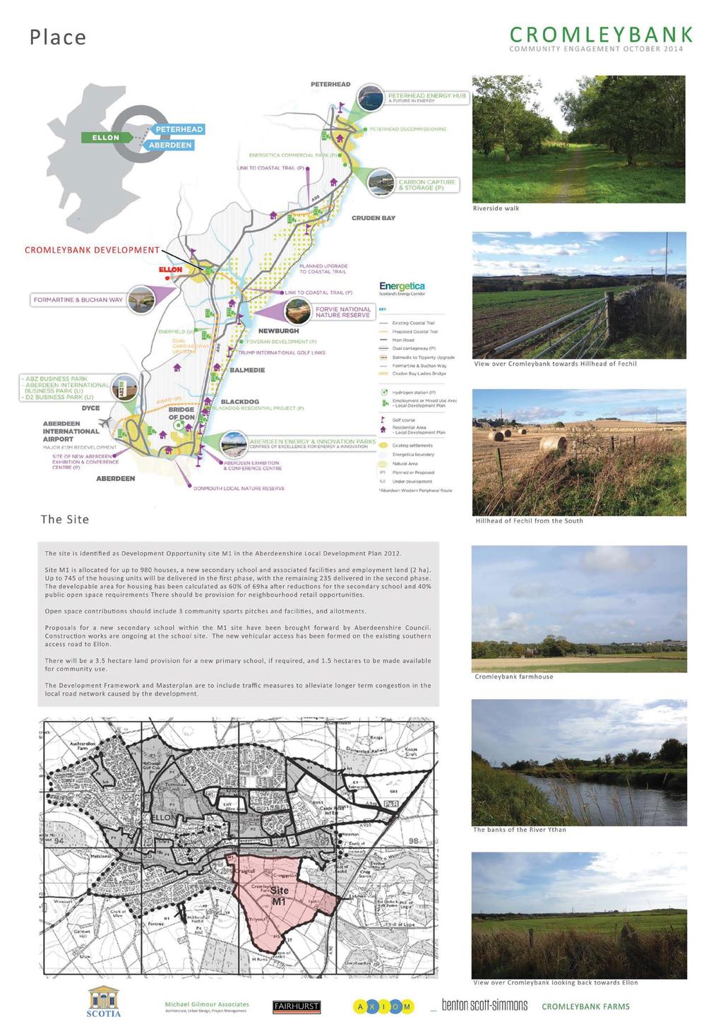
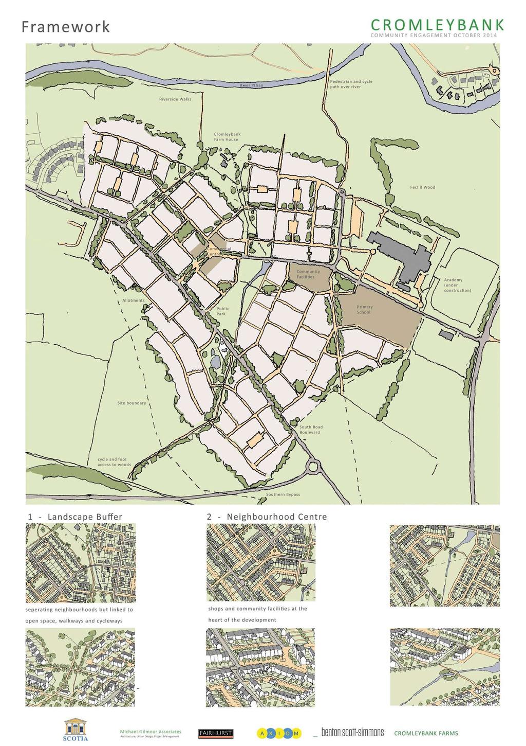
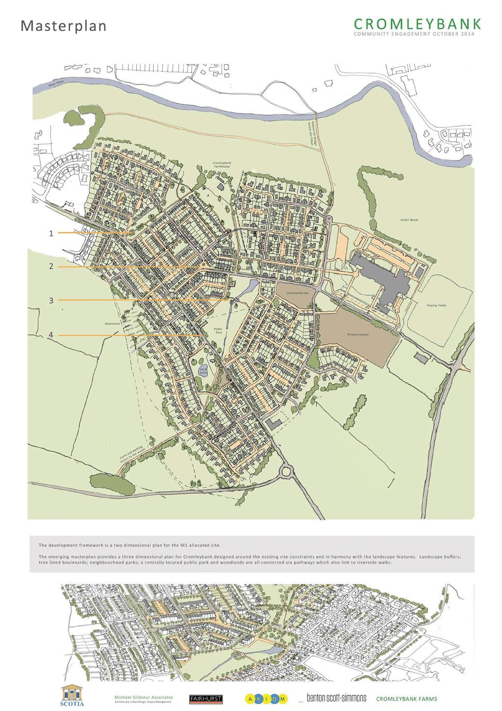
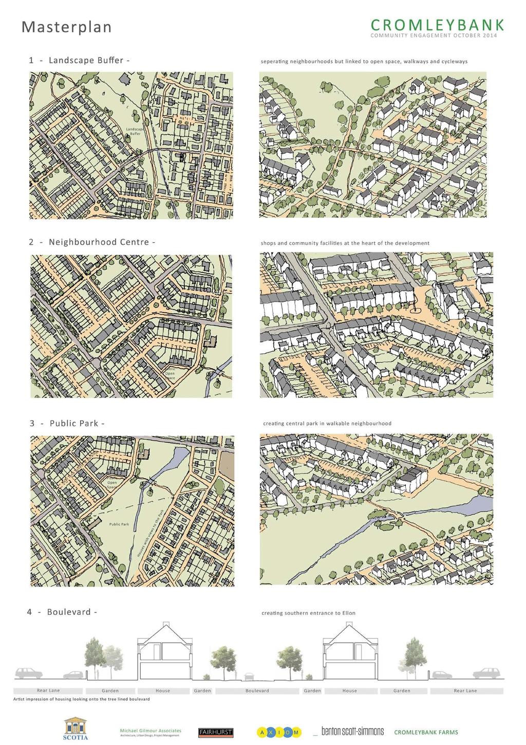
2 Site Analysis Overall Site Constraints As well as being constrained by the M1 LDP boundary the site has several major factors influencing the rational development of the site. We have control of all of the areas required to deliver the Masterplan Topography Where the contours are close together there are steep slopes. Within the site these generally lead to the flood plain from the Ythan or Hillhead of Fechil. Landscape Features Water courses running through the site have been influenced by farming practices and the form of the land. The continued sustainable drainage of the site is critical to the design of any development and could be integrated within a design solution. Trees & Landscaping Within the site there are trees and plants lining the water courses and following several of the field boundaries. An area of mature trees exists around the Cromleybank Farmhouse. Existing Buildings The secondary school is currently under construction and is considered as complete as part of this analysis. There is an existing private house at the crossroads on the south road entrance to Ellon. The existing farmhouse is of significance and is proposed to be kept. The working farm buildings have also been assessed and are not seen as significant in terms of their appearance. There are immediate neighbours to the western boundary of the site. Services There are several relatively large service routes running through and across the site. The position of these may influence development. Water Courses River Ythan Overhead Electricity Lines Water Main Flood Plain Gas Main Wooded Areas Local Plan Site M1 Boundary Development / Framework Development Framework Initial Concept Sketch Open Space There is a requirement for good quality public open space within new developments. The landscaping and constraints of the site provide an opportunity to have a large area of meaningful and usable public open space close to the walkable neighbourhood centre. A walkable neighbourhood is a 5 minute walk to the centre. This area can make use of the existing landform, watercourse and pond. The flood plain adjacent to the Ythan provides an area of public open space that connects to the existing historic centre of Ellon. In addition to this large area of public open space there is a centrally located public park and existing woodlands, all connected via pathways. Movement / Connection Development will inevitably increase traffic on the surrounding roads. A traffic assessment has been carried out and concluded that a southern bypass would relieve and re-direct traffic flows. A pedestrian/cycle is being built over the river Ythan as part of the school development. Development Areas When all design factors are combined and rationalised they begin to define clear development 'blocks' which are separated by a combination of roads, landscaping and open space. Services As well as the services currently running into and through the site (gas, electricity and water) additional services will also be required either because of capacity or logistics. A reservoir is proposed to the east of the site, located at a high point, to provide mains water. Waste water treatment is proposed to take place at a lower level at the north east side of Cromleybank. This location, away from development areas and at a lower level, reduces pumping requirements as well as the visual impact on the development and the surrounding landscape. Vehicular Movement Routes Wooded Areas Walkable Neighbourhood River Ythan Southern Bypass Route Public Open Space Pedestrian Movement Tree-lined Development Blocks Local Plan Site M1 Boundary Architecture, Urban Design, Project Management A X I O M
3
4
5
6
INTRODUCTION. Land off Main Road, Great Leighs. Introduction
 01 INTRODUCTION Introduction Gladman Developments Ltd have successfully invested in communities throughout the UK over the past 20 years, developing high quality and sustainable residential scheme. We
Application and Proposals. Part 211
 Application and Proposals Part 211 Site Location and Context The application site comprises two distinct land parcels totalling some 135 hectares. The site is bisected eastwest by Churchlands Development.
WELCOME GYPSY LANE. Wider Site Location plan. Proposals for the development of LAND OFF FOXLYDIATE LANE WEBHEATH. Proposals for the development of
 WELCOME The developers are preparing an outline planning application for a residential led development and need the community s views in order to develop the proposals further WHAT IS PROPOSED? A high
QUEENSTOWN LAKES DISTRICT COUNCIL SUBDIVISION DESIGN GUIDELINES
 Attachment C: Draft QLDC Subdivision Design Guidelines QUEENSTOWN LAKES DISTRICT COUNCIL DESIGN GUIDELINES A DESIGN GUIDE FOR AND DEVELOPMENT IN THE URBAN ZONES QUEENSTOWN OFFICE 10 Gorge Road Queenstown
Great Easton Sustainable Housing Development Sites - Site Seven, Broadgate extension site SHLAA Ref HSG/03)
") Great Easton Sustainable Housing Development Sites - Site Seven, Broadgate extension site SHLAA Ref HSG/03) 1. Introduction The Great Easton Neighbourhood Plan Group are preparing a Neighbourhood Plan
Great Easton Sustainable Housing Development Sites - Site Seven, Broadgate extension site SHLAA Ref HSG/03) 1. Introduction The Great Easton Neighbourhood Plan Group are preparing a Neighbourhood Plan
INTRODUCTION. Land south of Bishopswood Lane, Tadley
 0 INTRODUCTION THE SITE Introduction Gladman Developments Ltd. has successfully invested in communities throughout the UK over the past 0 years, developing high quality and sustainable residential, commercial
Neighbourhood Planning Site Assessment Pro-forma and Guide Version 2
 Neighbourhood Planning Site Assessment Pro-forma and Guide Version 2 September 2014 Site HNP 006 Land East of Stanbridge Road and North of Lower Road 1. Background information Site location and use Site
WELCOME. Land North of STEVENAGE. We would like to thank you for attending our public exhibition today.
 WELCOME We would like to thank you for attending our public exhibition today. The purpose of this event is to share our proposals and hear your thoughts on our ideas. Members of the project team are on
Statement of Community Involvement LAND OFF SOUTHDOWN ROAD HORNDEAN, HAMPSHIRE
 LAND OFF SOUTHDOWN ROAD HORNDEAN, HAMPSHIRE CONTENTS Page 1. Introduction 3 2. Pre-application Discussions 4 3. The Consultation Process 5 4. Consultation Feedback 7 5. Responses to Consultation Feedback
South of Hillside Road West, Rothbury. Design and Access Statement with Design Code. Outline Planning Application May 2016
 Outline Planning Application May 2016 Design and Access Statement with Design Code Jane Darbyshire and David Kendall Ltd This Design and Access Statement has been produced by Jane Darbyshire and David
community engagement 09/14
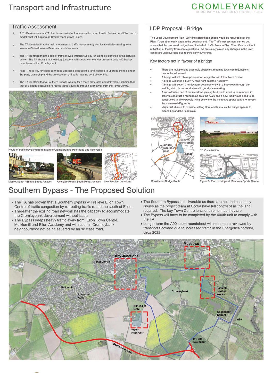
 scotia homes Village - A addition to Scotia Homes commitment to local developments within the Energetica Corridor and Aberdeenshire. INVERUGIE MEADOWS 354 NO. HOMES CASTLETON 130 NO. HOMES CROMLEYBANK
OP Council Resolution June 16, Planning and Development Services
 OP-08-01 Council Resolution June 16, 2008 Planning and Development Services Kingsgate Landing Outline Plan Table of Contents 1.0 Introduction 1 1.1 Purpose of Plan 1 1.2 Plan Area Location 1 1.3 Ownership
Environmental and Landscape Mapping
 Environmental and Landscape Mapping In support of the Calveley Neighbourhood Plan November 2016 Project Name and Number: Calveley Neighbourhood Plan 16-025 Document Name and Revision: Environmental and
ENVIRONMENTAL AND LANDSCAPE MAPPING
 APPENDIX IV : Environmental and Landscape Mapping ENVIRONMENTAL AND LANDSCAPE MAPPING Calveley Neighbourhood Plan November 2016 ENVIRONMENTAL AND LANDSCAPE MAPPING Calveley Neighbourhood Plan Calveley
Response by The Dartington Hall Trust
 Consultation Response by The Dartington Hall Trust Site Reference: SH_39_02_08/13 Contents Introduction 1 Site Description 2 Development Proposal and Context 3 Site Technical Assessment 4 Planning Policy
HARDWICK GREEN, King s Lynn. Welcome to our Exhibition. What are your views? Introduction to the site and proposals. About us
 HARDWICK GREE, King s Lynn Welcome to our Exhibition Welcome to our exhibition, which is being held to provide you with the opportunity to understand and comment upon our proposals for new residential
vision & process willowburn, tarves community engagement 04/18
 vision & process Historic Conservation area Scotia intend to create a high quality residential development based upon best practice urban design principles. This will include a contemporary reinterpretation
New Homes at Winton East
 View toward Winton East from Caerketton Hill Aerial photograph of South Edinburgh: Winton East Site Location Indicative proposal Welcome Thank you for coming to the Winton East public exhibition. We would
HURSTPIERPOINT SAYERS COMMON PARISH COUNCIL
 HURSTPIERPOINT SAYERS COMMON PARISH OFFICE TRINITY ROAD HURSTPIERPOINT HASSOCKS WEST SUSSEX BN6 9UY TEL: 01273 833264 FAX: 01273 834976 E-MAIL: HURSTPIERPOINT.PC@BTINTERNET.COM WEB SITE: WWW.HURSTPIERPOINT-PC.ORG.UK
September A new neighbourhood at Kemsing Station. Concept Masterplan
 September 2018 A new neighbourhood at Kemsing Station Concept Masterplan 1 Kemsing Station Neighbourhood - Key Benefi ts Transport Hub Extra parking, station improvements and links across the district
Land at BROOK STREET PROPERTIES TENCREEK FARM, LISKEARD. Environmental Statement: Non-Technical Summary
 BROOK STREET PROPERTIES TENCREEK FARM, LISKEARD Land at Environmental Statement: Non-Technical Summary Introduction Brook Street Properties is applying to Cornwall Council for outline planning permission
A VISION FOR BLAIRGOWRIE
 Welcome to the Westpark Partnership and Lidl UK GmbH Community Presentation. The purpose of this presentation is for you to view and comment upon the revised and updated proposals for the allocated development
O l so n M e morial Highway, S t e , G o l d e n V a l l e y, MN Delano Laketown Homes Concept Plan
 N O R T H W E S T A S S O C I A T E D C O N S U L T A N T S, I N C. 4 1 5 0 O l so n M e morial Highway, S t e. 3 2 0, G o l d e n V a l l e y, MN 5 5 4 2 2 T e l e p h o n e : 7 6 3. 9 5 7. 1 1 0 0 W
CROWN POINT SUBDIVISION
 CROWN POINT SUBDIVISION A COMPARISON OF CONVENTIONAL VERSUS CONSERVATION SUBDIVISION DESIGN DEVELOPER: PAUL LUCIANO BUILDERS LAND PLANNING & DESIGN: DAVID LAIRD ASSOCIATES FUNDING PROVIDED BY: PA SEA GRANT
Project Site. Kyle Jacobson
 Project 2.002 - Site Kyle Jacobson The culmination of the semester s analysis in the Marigny concluded with a site proposal for an open space within the neighborhood. The site design focused on the relationship
Chapter 5: Natural Resources and Environment
 NATURAL RESOURCES AND ENVIRONMENT 5-1 5 Chapter 5: Natural Resources and Environment BACKGROUND AND INTENT Urban expansion represents the greatest risk for the future degradation of existing natural areas,
Ramsey Center area - potential BMP sites
 Ramsey Center area - potential BMP sites Lilly Branch Carlton St. 1 2 Joe Frank Harris Commons 3 4 8 5 East Campus Rd. 11 6 12 7 9 East Campus Deck 10 20 16 17 Ramsey Center 13 14 18 19 15 River Road Road
BRIDGE OF DON MASTERPLAN & PLANNING SUMMARY
 BRIDGE OF DON MASTERPLAN & PLANNING SUMMARY SITE LOCATION The site of the existing AECC lies in an area of predominately residential and business use in Bridge of Don and extends approximately 50 acres.
Former Panshanger Aerodrome, Welwyn Garden City Masterplan Scenarios. Mariposa Investments
 Former Panshanger Aerodrome, Welwyn Garden City Masterplan Scenarios Mariposa Investments Contents 1.0 Introduction 1 2.0 The Site and Surroundings 2 3.0 Local Area Context 6 4.0 Site Features 10 5.0 Development
1.0 INTRODUCTION. Brantham Industrial Area Regeneration - Factory Lane - Brantham
 1.0 INTRODUCTION Welcome to this exhibition of our proposals for the regeneration of the Brantham Industrial Area located off Factory Lane in Brantham. This presentation will give you an opportunity to
Land at Fiddington Hill Nursery, Market Lavington
 Land at Fiddington Hill Nursery, Market Lavington Briefing Report for Market Lavington Parish Council Persimmon Homes (Wessex) April 2016 Background This brief report has been prepared following the Market
Design Specifications & Requirements Manual
 11 PARKS & OPEN SPACES 11.1 DEFINITIONS... 1 11.1.1 Neighbourhood Parks... 1 11.1.2 District Parks... 1 11.1.3. Sport Parks... 1 11.1.4 Urban Parks... 1 11.1.5 Civic Spaces... 1 11.1.6 Open Space System...
South Whitehaven, Cumbria EIA
 South Whitehaven, Cumbria EIA Environmental Statement - Non Technical Summary June 2013 in association with 1. Introduction Story Homes is applying to Copeland Borough Council (CBC) for a new residential
TIDAPA Structure Plan
 TIDAPA Structure Plan Prepared by Tract Consultants 28 MARCH 2017 0217-0074 Table of Contents 01 STRATEGIC CONTEXT Executive Summary Regional Context Page 3 Page 4 02 LOCAL CONTEXT Aerial Photograph Local
5.0 Community Design Plan
 5.0 Community Design Plan The Community Design Plan for the Mer Bleue area is a composite of three plans: Land Use Plan Transportation Plan Municipal Servicing Plan Read together, these Plans and associated
Slough International Freight Exchange Proposals, Colnbrook+
 Welcome Welcome to this exhibition, which is being held in connection with our proposals for a new freight exchange facility on land to the north of the A4. Please take this opportunity to look at the
Linden Homes Proposals for land at Field Road, Ramsey
 Welcome Welcome to Linden Homes public exhibition displaying emerging proposals for the development of land at Field Road, Ramsey Linden Homes has an interest in this land and is currently preparing an
Linden Homes Proposals for land east of Glebe Farm, Sawtry
 Welcome Welcome to Linden Homes public exhibition displaying emerging proposals for the development of land east of Glebe Farm, Sawtry. Linden Homes has an interest in this land and is currently preparing
University Park, Worcester Non Technical Summary December 2011
 University Park, Worcester Non Technical Summary December 2011 Introduction UW Wrenbridge LLP, a Joint Venture Company of the University of Worcester and Wrenbridge Land Ltd (the Applicants ) intend to
Major Subdivision Sketch Plan Checklist
 This checklist provides specific requirements that are apart of the Sketch process. The entire process is described by the Huntersville Subdivision Review Process which details all the submittal and resubmittal
Design Specifications & Requirements Manual
 11 PARKS & OPEN SPACES 11.1 DEFINITIONS... 1 11.1.1 Neighbourhood Parks... 1 11.1.2 District Parks... 1 11.1.3. Sport Parks... 1 11.1.4 Urban Parks... 1 11.1.5 Civic Spaces... 1 11.1.6 Open Space System...
SITE ASSESSMENT CHECKLIST
 1. Site Details a. What is the site s name/reference? CR3 FORUM NEIGHBOURHOOD PLAN SITE ASSESSMENT CHECKLIST CR3NPCOH3016 Douglas Brunton Centre Park Rd b. Where is the site located? Caterham Hill urban
Information about the site we need to take into account
 Site considerations Site Boundary Vehicular access Building with potential Contamination Pedestrian access View corridors to Church tanc e Information about site we need to take into account Site Boundary
COMMUNITY DESIGN. GOAL: Create livable and attractive communities. Intent
 COMMUNITY DESIGN Intent An attractive, well-designed County will attract quality development, instill civic pride, improve the visual character of the community, and create a strong, positive image for
CHEBOYGAN COUNTY PLANNING COMMISSION
 CHEBOYGAN COUNTY PLANNING COMMISSION 870 SOUTH MAIN ST. PO BOX 70 CHEBOYGAN, MI 49721 PHONE: (231)627-8489 FAX: (231)627-3646 CHEBOYGAN COUNTY PLANNING COMMISSION MEETING & PUBLIC HEARING WEDNESDAY, NOVEMBER
Welcome to our public exhibition
 About Our Scheme Welcome to our public exhibition This exhibition gives you the chance to view and comment upon our emerging proposals for a new residential development of 68 new homes on the site of the
WELCOME. Olney Road, Lavendon INTRODUCTION. The Site. The Application. The Need for Housing. A Sustainable Location LAVENDON TURVEY OLNEY ROAD
 0 WELCOME INTRODUCTION Gladman Developments Ltd have successfully invested in communities throughout the UK over the past 0 years, developing high quality and sustainable residential, commercial and industrial
East Grove Public Realm
 H - - MP - Elephant Park Public Realm RO EY DN NEW KENT ROAD E AC PL The public realm has been designed to create an environment which is easy to move through, accessible to all, safe and playful. The
TABLE OF CONTENTS 1.0 INTRODUCTION GENERAL OBJECTIVES LAND USE DESIGNATIONS, OBJECTIVES AND POLICIES 4
 Schedule I- Redstone Golf Course Resort Area Sector Plan 1 TABLE OF CONTENTS 1.0 INTRODUCTION 3 2.0 GENERAL OBJECTIVES 3 3.0 LAND USE DESIGNATIONS, OBJECTIVES AND POLICIES 4 4.0 TRANSPORTATION AND ROAD
Checklists. Project Name: Location: File Number: Date of Submittal: Reviewer: Date: Applicant: Contact Name: Phone Number:
 Applicant: Contact Name: Phone Number: Email: Project Name: Location: File Number: Date of Submittal: Reviewer: Date: Concept Plan Requirements: I. General Project Information 1. Address or parcel number
HURON COMMUNITY PLAN
 CITY OF KITCHENER DEPARTMENT OF DEVELOPMENT AND TECHNICAL SERVICES PD 94/7 HURON COMMUNITY PLAN Recommended by Planning and Economic Development Committee: October 31, 1994 Adopted by Kitchener City Council:
8.0 Design and Form of Development 43/
 42/ 8.0 Design and Form of Development 43/ Rothwells Farm, Golborne/ Development Statement Figure 7. Site Constraints Key 44/ Site Boundary 360 Bus Route/Stops Existing Trees Underground Water Pipe Sensitive
THREE-STEP DESIGN PROCESS FOR OPEN SPACE SUBDIVISIONS
 00216106.DOC NMA/RRK 1/30/14 THREE-STEP DESIGN PROCESS FOR OPEN SPACE SUBDIVISIONS Open space subdivisions, sometimes called cluster developments, maintain a significant portion of a development site in
18 South of St Pegas Rd including west of Foxcovert Rd, south of Werrington parkway and east to the Car Dyke
 18 South of St Pegas Rd including west of Foxcovert Rd, south of Werrington parkway and east to the Car Dyke Information reviewed Historical background: SAJ ver2 June 2016 Classification Comments NCA 75
Proposed Amendment to the
 Proposed Amendment to the Carrigaline Electoral Area Local Area Plan Amendment No 1: Carrigaline (T-02, O-02 & U-02) August 2012 Proposed Amendment to the Carriagline Electoral Area Local Area Plan 2011
1. Nantwich - Planning for a Sustainable Future
 1. Nantwich - Planning for a Sustainable Future Cheshire East Council is charged with preparing its Development Plan to guide housing and other growth over the period to 2030. The Council intends to publish
Welcome to our Public Consultation
 About our development This exhibition gives you the chance to view and comment on our emerging plans for a proposed residential development located on land to the West of Alwyn Road, Rugby. Welcome to
Southwest Fleetwood Enclave
 Southwest Fleetwood Enclave Development Concept Plan Southwest Fleetwood Enclave 1 st Land Owners Meeting April 30 th, 2012 Presentation Overview Why the Plan? ; Overview & Purpose of Study; Constraints
Grade II listed building of significant social and cultural historical value
 Project title: Main Street Rotherham Town Centre Masterplan Rothe Don Street Grade II listed building of significant social and cultural historical value Land Dwg Nº Drawn:RK Scale@A3: 1 Quay West, 0161
Welcome to our exhibition
 Welcome to our exhibition The Homes & Communities Agency (HCA) welcomes you to this public exhibition explaining our proposals for the redevelopment of the former Lea Castle Hospital site. About the Homes
Chapter 2: OUTLINE PLANNING APPLICATION PROPOSALS. A New Garden Neighbourhood Matford Barton 17
 Chapter 2: OUTLINE PLANNING APPLICATION PROPOSALS A New Garden Neighbourhood Matford Barton 17 2.1. SUMMARY AND STATUS OF THE PROPOSALS 2.1.1. The parameter plans and associated wording in this chapter
SITE ASSESSMENT CHECKLIST
 1. Site Details a. What is the site s name/reference? SITE ASSESSMENT CHECKLIST CR3NPWHY 3007 Gasometer Site Godstone Road CR3 0EG b. Where is the site located? Wyhteleafe; Godstone Road. Urban category1
INTRODUCTION. Land off Beresford Road, Holt. Introduction. Site Description. Housing Need. Why is the site suitable for development?
 01 INTRODUCTION Introduction Thank you for taking the time to view this public exhibition and find out more about Gladman Development s latest proposals to develop a new sustainable community of up to
Holnicote Multi-Objective Flood Demonstration Project Steve Rose (JBA)
") Holnicote Multi-Objective Flood Demonstration Project Steve Rose (JBA) Pete Worrall (PAA), Gene Hammond (PAA), Nigel Hester (NT) & Zdenka Rosolova (JBA) Introduction Objectives Identify landscape scale
Holnicote Multi-Objective Flood Demonstration Project Steve Rose (JBA) Pete Worrall (PAA), Gene Hammond (PAA), Nigel Hester (NT) & Zdenka Rosolova (JBA) Introduction Objectives Identify landscape scale
Introduction. Cannock Road, Stafford. Introduction. The Site. The Application. The Need for New Housing
 01 Introduction Introduction Developments Ltd have successfully invested in communities throughout the UK over the past 30 years, developing high quality and sustainable residential, commercial and industrial
1. Welcome. Background
 1. Welcome The purpose of this exhibition is to provide you with an update on progress on the Kilnwood Vale Scheme. In order to improve the scheme and deliver key facilities earlier in the development,
6 Site Framework Strategies
 6 Site Framework Strategies 6.1 Introduction Section 6 identifies a number of specific areas which are considered to be key sites within the Plan area and which may have potential for development / redevelopment.
INTRODUCTION NORTH HEYBRIDGE GARDEN SUBURB
 INTRODUCTION This event is being hosted by the promoters of the proposed North Heybridge Garden Suburb who are working with Maldon District Council and other key stakeholders on the preparation of a comprehensive
Kibworth Harcourt. Introduction. Introduction
 Introduction Introduction Welcome to this public exhibition on the proposals for the delivery of new homes on land at The Kibworths. The purpose of today s exhibition is to give you the opportunity to
Land at Rampton Road. Cottenham
 Land at Rampton Road Cottenham Introduction TEP is preparing an outline planning application for 54 dwellings on 6.9 hectares of land adjacent to Rampton Road, Cottenham on behalf of the owners Cambridgeshire
Carterton Construction Ltd is bringing forward plans for up to 85 new family homes and extra care facilities on land east of Burford.
 Welcome Carterton Construction Ltd is bringing forward plans for up to 85 new family homes and extra care facilities on land east of. We are at the early stages of designing our proposals and have a number
West of Chichester Proposals for land to the west of Centurion Way 1 Welcome Introduction
 West of Chichester Proposals for land to the west of Centurion Way Welcome Introduction Welcome to this public exhibition for Linden and Miller Homes in connection with their proposals for a 600 home mixed
The proposals presented in September drew a large number of comments and feedback and have been grouped together as follows:
 Appendix A Stakeholder presentation + powerpoint slides Planning Context and Emerging Proposals presentation Nick Tyrrell, Alder King, Planning Consultants Alder King began by setting the site context
Derry City and Strabane District Council Planning Committee Report. Amended layout from approval A/2004/0462/F with reduction from 166 units
 Derry City and Strabane District Council Planning Committee Report COMMITTEE DATE: 1 st February 2017 APPLICATION No: APPLICATION TYPE: PROPOSAL: LOCATION: APPLICANT: AGENT: Full Planning application Amended
Built Up Area Boundary (BUAB)
") Parish Boundary Built Up Area Boundary (BUAB) Potential Sites Map not to scale DWELLING SIZE POLICY Residential developments must provide a mix of dwelling sizes (market and affordable) that reflect the
Parish Boundary Built Up Area Boundary (BUAB) Potential Sites Map not to scale DWELLING SIZE POLICY Residential developments must provide a mix of dwelling sizes (market and affordable) that reflect the
Land East of Cromwell Lane
 Land East of Cromwell Lane VISION DOCUMENT AUGUST 2016 The proposals for Land East of Cromwell Lane will be defined by existing landscape features, ensuring that the development offers a quality place
PUBLIC NOTICE UNDER CLAUSE 5 OF SCHEDULE 1 OF THE RESOURCE MANAGEMENT ACT 1991 PLAN CHANGE 12 TO THE OPERATIVE CITY OF NAPIER DISTRICT PLAN
 PUBLIC NOTICE UNDER CLAUSE 5 OF SCHEDULE 1 OF THE RESOURCE MANAGEMENT ACT 1991 PLAN CHANGE 12 TO THE OPERATIVE CITY OF NAPIER DISTRICT PLAN Public notice is given in accordance with Clause 5 of Schedule
Former Rockcliffe Airbase Community Design Plan Guiding Design Vision and Principles December 4, 2013
 APPENDIX 5 - Guiding Design Vision and Principles Former Rockcliffe Airbase Community Design Plan Guiding Design Vision and Principles December 4, 2013 Vision Statement The redevelopment of the former
Site ref: AS06 Site Name or Address: Murreys Court, Agates Lane
 Site ref: AS06 Site Name or Address: Murreys Court, Agates Lane Proposed Land Use: Total Site Area (Ha): Housing 1.85 Ha Description: It is understood that the owner has no plans to dispose of the site
Deputation to Building & Planning Committee November 19, 2012
 Deputation to Building & Planning Committee November 19, 2012 Proposed Rezoning Special Sites 8 and 11 OZ 12/003 W7 Presented by Sharon Giraud, President GWHA executive@gordonwoods.ca Gordon Woods Our
Holmberg & Howe, Land Surveyors and Civil Engineers Zoning District: R-35
 Development Impact Statement Name of Project: Red Tail Drive Acreage: 13.5 Acres± Type of Project: Residential Subdivision Owner: 96 East Street Development, LLC Location: rear of 112 East Street Parcel
LAND OFF TOLLBAR WAY, HEDGE END PUBLIC CONSULTATION. Proposed Residential Development
 LAND OFF TOLLBAR WAY, HEDGE END PUBLC CONSULTATON Proposed Residential Development YOUR VEW MATTERS TO US PROPOSED STE AREA Thank you for taking the time to read this information leaflet regarding a proposed
Welcome - Halse Yard, Honiton
 Welcome - Welcome to this consultation regarding potential new Starter Homes on the Halse Farm Machinery site at West End, Honiton. The purpose of this exhibition is to provide the community with an early
Drainage. Alignment K:\D (D102241) SHERFORD\CONSOLIDATED PLANNING DOCUMENTS\MAIN STREET\SHERFORD MAIN STREET NARRATIVE REVISION
 SHERFORD\CONSOLIDATED PLANNING DOCUMENTS\MAIN STREET\SHERFORD MAIN STREET NARRATIVE REVISION") The Main Street therefore provides a key link for a HQPT bus system between the Park and Ride, through Sherford onto the A379 and Plymouth City Centre. There is no definitive description of an HQPT system,
The Main Street therefore provides a key link for a HQPT bus system between the Park and Ride, through Sherford onto the A379 and Plymouth City Centre. There is no definitive description of an HQPT system,
Carrville District Centre Urban Design Streetscape Master Plan Study
 THE CITY OF VAUGHAN Carrville District Centre Urban Design Streetscape Master Plan Study Council Approved June 2010 THE CITY OF VAUGHAN Carrville District Centre Urban Design Streetscape Master Plan Study
Kirkcaldy South West. Invertiel and Tyrie Farms. Environmental Statement Non Technical Summary. Volume 1
 Kirkcaldy South West Environmental Statement Non Technical Summary Volume 1 Invertiel and Tyrie Farms August 2010 CALA Homes (East) Ltd and Mactaggart & Mickel Ltd Volume 1 Non Technical Summary Contents
DESIGN REVIEW STANDARDS CITY OF LANGLEY
 DESIGN REVIEW STANDARDS CITY OF LANGLEY I. INTRODUCTION The City of Langley is fortunate to have a strong sense of place and unique quality. This comes in part from its special setting along Saratoga Passage,
Have your say WELCOME. Land off Mill Lane, Monks Risborough. Welcome
 01 WELCOME Welcome Gladman Developments Ltd have successfully invested in communities throughout the UK over the past 20 years, developing high quality and sustainable residential, commercial and industrial
HOROWHENUA DEVELOPMENT PLAN June create a safe crossing for children moving to and from the school and other areas. 7.8 Ohau
 7.8 Ohau create a safe crossing for children moving to and from the school and other areas. Ohau has a traditional village form with a collective of school, church and reserve at the main road intersection.
WELCOME. A new vehicular access point off Sudbury Road. A proposed secondary vehicular access point off either Tylneys Road and Winston Way.
 0 WELCOME INTRODUCTION Gladman Developments Ltd have successfully invested in communities throughout the UK over the past years, developing high quality and sustainable residential, commercial and industrial
Plumpton Neighbourhood Plan Site Assessment Report
 Plumpton Neighbourhood Plan Site Assessment Report May 2016 1 Contents 1. Introduction 3 2. Methodology 4 2.1 Identification of Potential Sites 4 2.2 Assessment Process 5 2.3 Assessment Criteria 6 2.4
Blandford Forum Town Council, Blandford St Mary Parish Council and Bryanston Parish Council
 Blandford Forum Town Council, Blandford St Mary Parish Council and Bryanston Parish Council Blandford + Neighbourhood Plan 2 Pre-Submission Plan Consultation (November 2018) Representations submitted on
Carr Lodge Doncaster COMMUNITY PLANNING DAY 28 MARCH 2009
 Carr Lodge Doncaster COMMUNITY PLANNING DAY 28 MARCH 2009 - SATURDAY 28 MARCH 2009 CONTENTS INTRODUCTION 4 Workshops - MORNING 5 Workshops - AfTERNOON 10 The Way forward 15 Key THEMES 16 APPENDICES 17
WELCOME. Land west of Great Canfield Road, Takeley. Welcome. Have your say. Pegasus Urban Design
 01 WELCOME Welcome Gladman Developments Ltd have successfully invested in communities throughout the UK over the past 20 years, developing high quality and sustainable residential, commercial and industrial
ARTICLE IV: DEVELOPMENT STANDARDS 404 MASTER PLANNING
 IV 13 404 MASTER PLANNING Master Planning through the Site Analysis (Master Planning Site Analysis) or Planned Development (Master Planning Planned Development) is provided to encourage development which
Water Sensitive Urban Design Site Development Guidelines and Practice Notes. Appendix
 Water Sensitive Urban Design Site Development Guidelines and Practice Notes Appendix 108 Appendix A Water sensitive developments involve simple design and management practices that take natural site features
River Corridor Overlay Zone (RCOZ) Article 5
 Article 5") River Corridor Overlay Zone (RCOZ) Article 5 The site is in one of two designated districts. The first is the CBD (central business district) River District, which recognizes the urban character and unique
River Corridor Overlay Zone (RCOZ) Article 5 The site is in one of two designated districts. The first is the CBD (central business district) River District, which recognizes the urban character and unique
Great Hammerton Growth Area: Our Vision August Hammerton Growth Area Harrogate: Our Vision
 Great Hammerton Growth Area: Our Vision August 2015 Hammerton Growth Area Harrogate: Our Vision i Contents 1.0 Introduction 1 2.0 Our Vision 3 3.0 Principle of Development 5 4.0 Site Context 7 5.0 Townscape
AERIAL PHOTO WITH 3D RENDER PLASDWR DESIGN AND ACCESS STATEMENT
 DESIGN PROPOSALS 04 AERIAL PHOTO WITH 3D RENDER 60 DESIGN PROPOSALS 04 THE MASTERPLAN MASTERPLAN R.0319_08G 61 USE & AMOUNT 4.1 (The Town and Country Planning (Development Management Procedure) (Wales)
2. Analysis. DRAFT Gerald Richards & Pleasantview Park Master Plan
 DRAFT Gerald Richards & Pleasantview Park Master Plan 19 Historic Features According to the National Register of Historic Places and the National Historic Landmarks Program, there is nothing of national