SPECIAL COMMITTEE OF THE WHOLE DECEMBER 9, 2002 BLOCK 12 BLOCK PLAN FILE BL CASTAN BATHURST TESTON CORPORATION ET AL PRELIMINARY REPORT
|
|
|
- Griffin Harrington
- 5 years ago
- Views:
Transcription
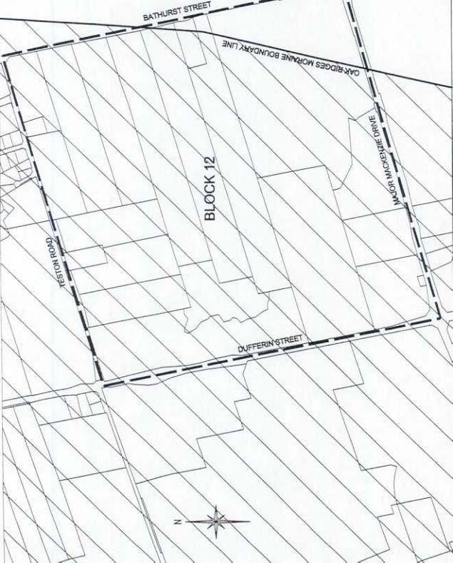
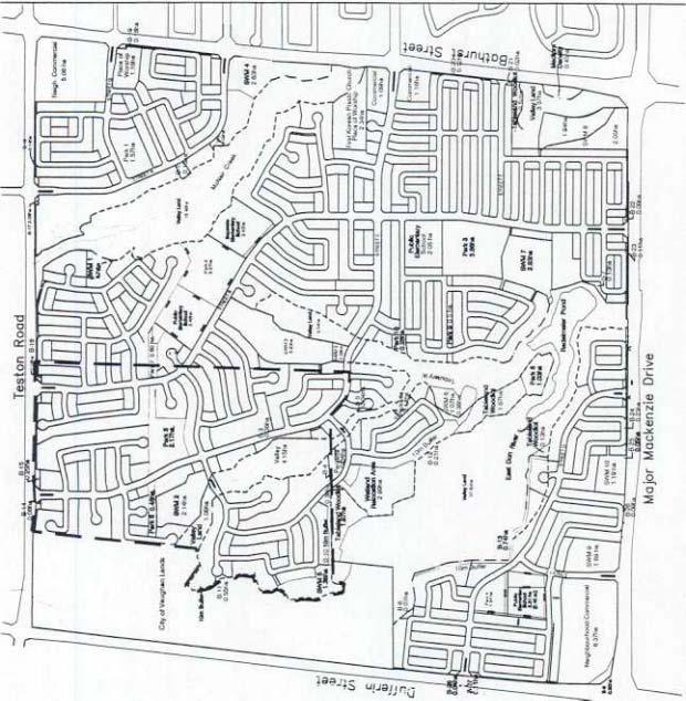
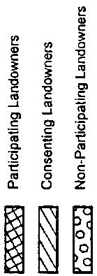
1 SPECIAL COMMITTEE OF THE WHOLE DECEMBER 9, 2002 BLOCK 12 BLOCK PLAN FILE BL CASTAN BATHURST TESTON CORPORATION ET AL PRELIMINARY REPORT Recommendation The Commissioner of Planning recommends: THAT the Public Meeting for File BL (Castan Bathurst Teston Corporation et al) BE RECEIVED, and that any issues identified be addressed by Staff in a comprehensive report to the Committee of the Whole. Purpose On September 16, 1999, Block 12 property owners submitted a Block Plan application proposing comprehensive development for approximately 3900 residential units (13,150 residents), commercial, school and park uses, along with valleylands, woodlots and stormwater management ponds. The land ownership consists of 13 participating property owners, two consenting owners and two non-participating owners. In November 2002, the Owners submitted a revised Block 12 Plan to develop the ha of the participating, consenting and non-participating owners lands. Block 12 also includes 35 ha owned by the City for future park and conservation uses. The site statistics for the revised proposal are as follows: 158.1ha Low Density Residential 0.5ha Medium Density Residential 11.4ha Neighbourhood Commercial (2 sites ha and 5.06 ha) 2.25ha Convenience Commercial (2 sites ha and 1.09 ha) 3.5ha Place of Worship (2 sites ha existing and 1.16 ha proposed) 8.8 ha Elementary Schools (3 Public and 1 Catholic) 16.3ha Parks/Parkettes 3.8ha Open Space/Landscape Buffers 19.2ha Tableland Stormwater Management Ponds 3.3ha Valley Stormwater Management Ponds 7.3ha Tableland Woodlot/Wetland Area 65.1ha Valleyland 65.7ha Roads Background - Analysis and Options Location The ha site is bounded by Dufferin Street to the west, Major Mackenzie Drive to the south, Bathurst Street to the east and Teston Road to the north, within Lots 21 to 25, Concession 2, City of Vaughan. The surrounding land uses are: North - Teston Road; estate residential, agricultural, valleylands, (RR Rural Residential, A Agricultural and OS1 Open Space Conservation Zones) South - Major Mackenzie Drive; residential, agricultural, valleylands, (RR Rural Residential, A Agricultural and OS1 Open Space Conservation Zones) East - Bathurst Street; residential and commercial (Town of Richmond Hill)
2 West - City park and conservation lands, Dufferin Street; future golf course, valleylands, residential, vacant commercial, (OS1, OS1-H, OS2, and OS2-H Open Space Conservation Zones, and C1-H Restricted Commercial Zone) Land Use Status The lands are designated Low Density Residential, Low Density Residential Special Policy Area, Neighbourhood Commercial, Valleylands and Tableland Woodlots, with provisions for school sites, neighbourhood parks and stormwater management ponds by OPA 600. Block 12 is the most northerly block in the urban village of Carrville, designated by OPA 600 for a planned population of approximately 60,000. The lands are designated Settlement Area and Natural Core Area by the Oak Ridges Moraine Conservation Plan (ORMCP). The lands are zoned A Agricultural Zone and OS1 Open Space Conservation Zone by By-law 1-88, subject to Exceptions 9(918) and 9(30). Notice On November 21, 2002, a notice of public meeting was placed in the Vaughan Citizen newspaper, and circulated to all property owners within Block 12 and the Town of Richmond Hill. No comments have been received to date. Any responses received will be addressed in the technical review and included in the detailed staff report for a future Committee of the Whole meeting. Preliminary Review Following an initial review of the proposed Block Plan, Staff has identified the following matters to be reviewed in greater detail: Housing and Residential Densities the Low Density Residential designation allows for uses such as detached and semidetached dwellings at maximum density of 22 units per net ha, with a maximum average net density of 16 to 18 units per ha (uph) for the Block; the Low Density Residential Special Policy Area designation (in the northwest part of the Block, adjacent to the City-owned lands) allows a density of 5 to 14 uph, subject to the resolution of the groundwater and landform conservation concerns; the Block Plan proposes an overall gross density of 13.4 uph for all the lands; the proposed density is 18.8 uph for the Low Density Residential lands and 12.5 uph for the Low Density Residential Special Policy Area lands; the Block Plan has been modified, and revised density and unit calculations for these two designations are required; a Medium Density Residential/Commercial use has been proposed on Bathurst Street, on a site surrounded by valleylands, and would provide detached and semi-detached dwellings and street townhouses at a density of 46 uph; this 0.5 ha site, would be the only Medium Density Residential area within Block 12; the unit type, appropriate setbacks/buffers and impact of the use on the surrounding valleylands have to be determined and may affect the density; when OPA #600 was adopted by Council, this proposal was refused, and is now the subject of an OMB referral expected to proceed to a hearing in 2003; Block 12 proposes approximately 3900 residential units, to accommodate about 13,150 residents, which is less than the projected 4119 residential units and 14,375 residents in Schedule B of OPA 600; the reduction reflects an environmentally sensitive design for development on the Oak Ridges Moraine;
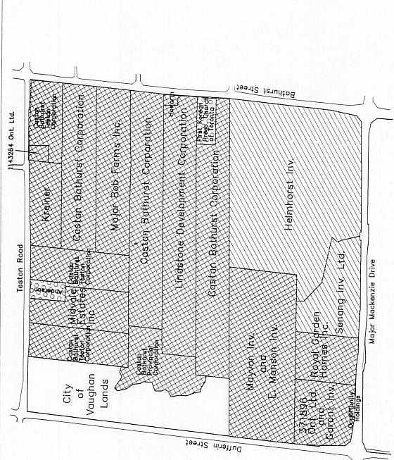
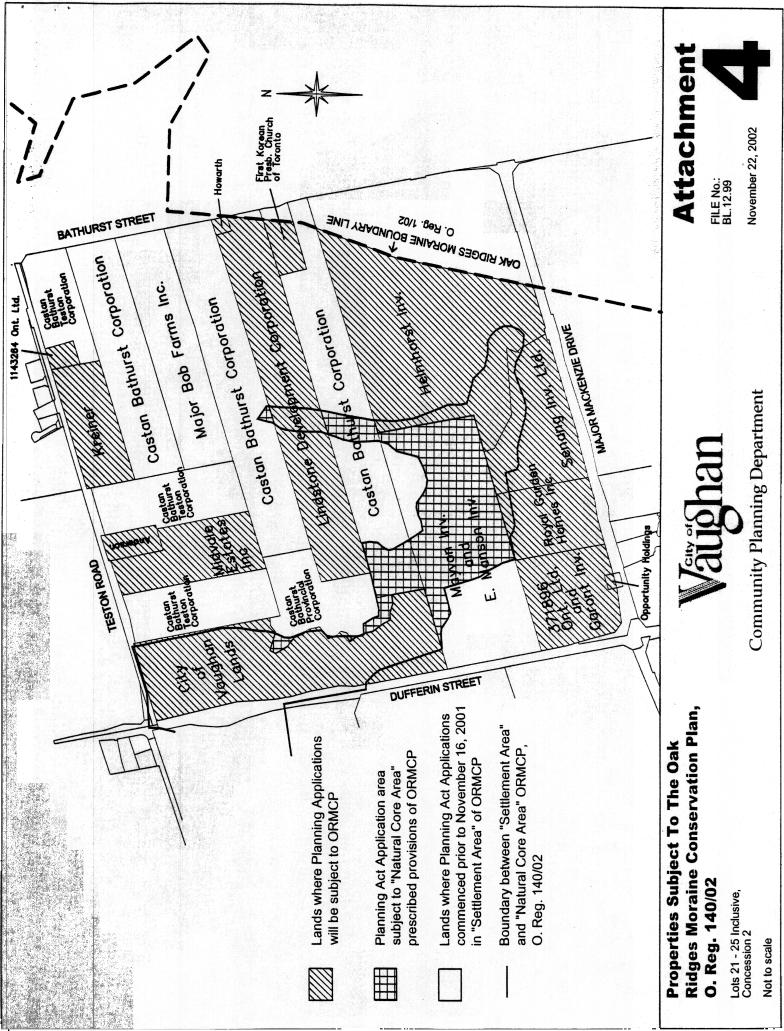
3 Development Phasing OPA 600 provides that Block Plan submissions include a Council-approved plan to phase development within the block, such that each phase includes no more than 7500 persons; the phasing of the development of Block 12, which will ultimately house more than 13,000 residents, needs to be examined with respect to servicing, arterial road improvements, internal road construction and development of park/school sites; Oak Ridges Moraine/Environment part of the Block 12 lands are within the Oak Ridges Moraine (ORM), designated as Settlement Area and Natural Core Area by the Oak Ridges Moraine Conservation Plan (ORMCP); the prescribed provisions of the ORMCP apply to applications commenced but not decided upon prior to November 16, Three plans of subdivision, 19T-99V08 (Castan Bathurst Corporation), 19T-00V02 (Mayvon Investments) and 19T-89124(R) (Major Bob Farms), along with the related zoning files, have been commenced prior to November 16, 2001, and are only subject to the prescribed provisions of the ORMCP. There are no prescribed provisions in the ORMCP for the Settlement Area. All of the Major Bob property is designated Settlement Area and as such, the applications filed are not affected by the ORMCP. Those portions of the Castan and Mayvon applications within the Natural Core Area are subject to the prescribed provisions in the ORMCP for Natural Core Areas ; Planning Act applications on the Kreiner and Midvale Estates Inc. properties were closed in March 2000; no new Planning Act applications were filed on these properties prior to November 16, 2001; as such, future Planning Act applications on these and other properties where applications were not filed prior to November 16, 2001 will be subject to the ORMCP (see Attachment 4); the lands subject to the ORMCP total ha and represent 47.66% of the Block Plan application area; the Master Environmental Servicing Plan (MESP) may need to provide a higher level of environmental protection and may require updating to demonstrate how the proposed development for these lands conforms to the ORMCP; the MESP requires updating to demonstrate conformity to the ORMCP; information concerning the key natural heritage features and hydrologically sensitive features needs to be reviewed to determine applicability to the Block 12 lands; the appropriate landform conservation requirements to address policy objectives for lands in the northwest portion of the Block need to be determined in consultation with York Region and the Province; MESP issues pertaining to the hydrogeology, water balance, slope stability and geotechnology are under review; the MESP needs to be finalized on such items as confirmation of final top-of-bank limits/setbacks for all properties and tableland woodlots, and public/private ownership of other staked natural features; an environmental impact statement (EIS) is required for the design of the stormwater management pond outfall on the City lands, including assessing the option of tunneling the outfall for the stormwater management ponds to minimize the impact of cutting
4 through the forested valley slope; further details, e.g. cross sections for the stormwater management ponds, are required; floodplain hydraulic modeling and mapping and erosion analysis are required for review by the Toronto and Region Conservation Authority; the proposed wetland pond relocation, and the final limits of the valleylands and buffering/setbacks, are to be determined through the MESP and Block Plan process; Servicing a development phasing and infrastructure staging plan, including interim servicing for sanitary, water and stormwater management, is required for all of the Block 12 lands; details respecting the timing of delivery of water supply to the Block will need to be addressed; at the draft plan stage, a water supply analysis and hydraulic design will be required to support servicing schemes for both Pressure District #7 and Pressure District #8; additional details are required for the ultimate servicing strategy for the northeast corner of the Block; successive Pressure District #8 watermain capital projects have been identified in the 10 year budget to eventually link the new North Maple Pumping Station in Vaughan with the Jefferson Pumping Station in Richmond Hill by 2007; this interconnection appears to be required to service approximately 2/3 of the Pressure District #8 area in the northwestern part of the Block; there is currently an interim servicing strategy for the northwestern portion of the Block; the Block Plan requires updating to identify the ultimate servicing strategy for the northwestern portion of the Block; the northern third of Block 12 is located in Pressure District #8 and the water supply to that Pressure District is dependent on the construction of the proposed Regional Pressure District #8 Vaughan/Richmond Hill Interconnection Trunk Watermain; the remaining lands in Block 12 are within Pressure District #7 and the water supply can be provided by the recently constructed Regional Pressure District #7 Interconnection Trunk Watermain; Block 12 is to receive sanitary sewer service by the proposed Regional Bathurst Street Sanitary Trunk Sewer; this sewer, which is located approximately 3 km to the south of Block 12, is to be constructed to the mid-point of Block 10 by 2004/2005 according to the Regional Master Plan; interim servicing needs to be provided to service the Block until the Regional Bathurst Street Sanitary Trunk Sewer reaches the Block; a clean water collector pipe system is proposed to maintain the existing water balance and enhance water recharge through the collection of roof water into pipes to slowly infiltrate out into gravel bedding in the road; this is acceptable in principle, but further design and maintenance details are required; the commenting departments/agencies will need to review the results of the field prototype monitoring the clean water system to determine if this system is appropriate for the proposed development; the stormwater management ponds, including a review of the pond grading, configuration, access, frontage and landscaping, are to be subject to the appropriate maintenance and safety procedures developed by the City; all Regional infrastructure work, including road widenings, water and waste water system improvements that are necessary to support development in Block 12, are to be identified in the MESP; a sidewalk and trail/walkway plan is to be prepared to the satisfaction of the City;
5 Transportation a revised transportation study is required for the latest Block Plan proposal; a transportation management plan will be required when the road network is finalized and prior to Block Plan approval, and is to include internal traffic control/traffic calming requirements; the primary roads in Block 12 will be aligned at Major Mackenzie Drive with the primary roads in Block 11 as shown in the current Block 12 Plan; all primary road intersections with a Regional road will require a left-turn lane, right-turn lane and illumination in accordance with Regional standards; the right-of-way of the primary roads should be widened near the intersection with the Regional roads to accommodate any required turning lanes and raised medians; where a raised median is proposed on a primary road at the intersection with a Regional road, two inbound lanes should be provided; driveway access to primary roads will be limited to the satisfaction of the City; the sections of Major Mackenzie Drive and Dufferin Street along the frontage of the Block are not currently in the Region s 10 Year Capital Plan, but are in the Region s Development Charges By-law and scheduled to be widened by 2021; the transportation study for the Block Plan assumes that Major Mackenzie Drive would be widened to four through lanes within the time horizon of the Study (ie.2011), which may not be the case; the transportation study should be updated to include the analysis of the 2011 total traffic level of service for the affected intersections; the section of Teston Road from Dufferin Street to Bathurst Street is scheduled for reconstruction by the Region in 2003; the existing vertical profile of Teston Road does not provide adequate sight lines for the Block, therefore the Region recommends that draft plans not be finalized until the environmental assessment for Teston Road is complete; the primary road intersections to Teston Road cannot be constructed until Teston Road is reconstructed with a new vertical profile; the Region requires that the proposed primary road intersection to Dufferin Street be confirmed at a location approximately 545m north of Major Mackenzie Drive; three road crossings over the valley are proposed; additional information concerning the preliminary design details, criteria and related assessment of environmental impacts on the valleylands are to be included in the MESP to the satisfaction of the City and the Toronto and Regional Conservation Authority; the Block 12 owners will be required to provide additional preliminary grading information to confirm conformity with the City s lot grading and vertical road geometrics criteria, given the diverse topography of the Block, specifically in the northwest portion; the Block 12 owners need to demonstrate how the residents in the central portion of the Block can have more direct vehicular or pedestrian connections to the neighbourhood commercial areas at the Bathurst Street/Teston Road and Major Mackenzie Drive/Dufferin Street locations, in length of the intervening valleylands; the proposed alignment of the southerly primary road connecting to Bathurst Street is on lands owned by Helmhorst Inv., a consenting landowner; Helmhorst Inv. has agreed to allow the use of the lands for road access and an agreement to this effect must be secured prior to Block Plan approval; the MESP is required to address the implications of the new Municipal Class Environmental Assessment process as it relates to the road network in the Block;
6 Transit bus stops should be located every 250m to 300m; the bus stop locations proposed for the Block may need to be adjusted; in the southcentral part of the Block, southwest of Street C and Street B, there is a residential neighbourbhood which is more than 400m away from the nearest transit stop; a pedestrian walkway, possibly through Park 3, would reduce the walking distance to transit service, which may eventually be provided along Street B; all streets that have been designated for transit appear to have sidewalks proposed for both sides of the street; the Region requires that this remains; the Block Plan designates both Streets D and E in the southwest portion of the Block as primary roads without transit; these Streets should be designed to accommodate transit to allow the option of using the roads for short-term, on-street bus looping as transit service on Dufferin Street is required north of Major Mackenzie Drive; information concerning potential transit routes, bus stops and shelter locations within the Block should be provided to future residents through sales offices and notification clauses in the agreements of purchase and sale; Noise Attenuation a detailed noise assessment is required to determine needed noise mitigation measures along arterial and primary roads, such as berming, landscaping, acoustic fencing and air conditioning, due to the potential noise generated from the roads and commercial uses; Urban Design Block 12 will be subject to the City s new urban design standards; the appropriate interface between the commercial and residential lands concerning the siting of the commercial buildings, minimization of land use conflicts with adjacent residential uses, driveway access, landscaping and noise attenuation, need to be determined; a detailed landscape master plan is required for the Block; the interface between the City s lands at Dufferin Street/Teston Road and the Block 12 development needs to be reviewed with respect to the most appropriate design treatment, i.e residential lotting pattern, roads, sidewalk/trail connections and grading; Park/School Sites the size and location of parks and linear parks needs to be finalized, in consultation with the City and School Boards, providing for at least ha of parkland dedication; configuration of the park and school campus location in the southwest portion of the Block needs further review; the locations and configuration of the neighbourhood commercial, park/school campus and interface of these uses to one another at Dufferin Street/Major Mackenzie Drive, needs to be examined with respect to road access to Dufferin Street, driveway access and traffic movement; the Block Plan provides for four elementary school sites ranging from 2 ha to 2.46 ha; the York Region Catholic School Board has no objection to the 2.42 ha site and its location; the York Region Public School Board has no objection to two of the three sites and their location, however, the third site requires further review;
7 the Public School Board requires a secondary school site, with road and servicing connections, in Block 11; the Board is concerned that the secondary school site has not been secured and cannot agree to approval of the Block 12 Plan until this is resolved; Heritage archaeological assessments are outstanding for most of the Block, including the woodlots and valleylands; further archaeological information is required for lands already assessed; several structures are recommended for preservation and are not to be demolished; the development in the Block should be sympathetic to the existing heritage buildings; Conclusion The above issues, but not limited to, will be considered in the technical review of the Block Plan application along with the MESP and other supporting reports, together with comments expressed by the public and Council at the public meeting or in writing. These will be addressed in a comprehensive planning report to a future Committee of the Whole meeting. In particular, Staff will review the proposal in accordance with the policies in OPA 600, the ORM Conservation Act and Plan, and the City s new Urban Design Standards. Attachments 1. Location Map 2. Block 12 Plan 3. Property Ownership 4. Properties subject to the ORM Conservation Act and Plan Report prepared by: Judy Jeffers, Planner, ext Paul Robinson, Senior Planner, Policy, ext Wayne McEachern, Manager, Policy Planning, ext Respectfully submitted, MICHAEL DeANGELIS Commissioner of Planning JOANNE R. ARBOUR Director of Community Planning /LG R:\WORKING\JEFFERSJ\CASTAN.CW
8
9
10


11
SPECIAL COMMITTEE OF THE WHOLE DECEMBER 9, 2002 BLOCK 57/58 WEST BLOCK PLAN BLOCK PLAN FILE BL.57/58W.99 HUNTINGTON BUSINESS PARK LAND OWNERS
 SPECIAL COMMITTEE OF THE WHOLE DECEMBER 9, 2002 BLOCK 57/58 WEST BLOCK PLAN BLOCK PLAN FILE BL.57/58W.99 HUNTINGTON BUSINESS PARK LAND OWNERS Recommendation The Commissioner of Planning recommends: THAT
9 CITY OF VAUGHAN OFFICIAL PLAN AMENDMENT NO BOCA EAST INVESTMENTS LIMITED
 9 CITY OF VAUGHAN OFFICIAL PLAN AMENDMENT NO. 631 - BOCA EAST INVESTMENTS LIMITED The Planning and Economic Development Committee recommends the adoption of the recommendations contained in the following
THAT Site Development Application DA (Villa Charities Inc./Villa Colombo DiPoce Campus) BE APPROVED, subject to the following conditions:
 BE APPROVED, subject to the following conditions:") COMMITTEE OF THE WHOLE JUNE 16, 2003 SITE DEVELOPMENT FILE DA.02.058 VILLA CHARITIES INC./VILLA COLOMBO DIPOCE CAMPUS Recommendation The Commissioner of Planning recommends: THAT Site Development Application
COMMITTEE OF THE WHOLE JUNE 16, 2003 SITE DEVELOPMENT FILE DA.02.058 VILLA CHARITIES INC./VILLA COLOMBO DIPOCE CAMPUS Recommendation The Commissioner of Planning recommends: THAT Site Development Application
12 AMENDMENT NO. 149, TOWN OF MARKHAM HIGHWAY 404 NORTH SECONDARY PLAN
 12 AMENDMENT NO. 149, TOWN OF MARKHAM HIGHWAY 404 NORTH SECONDARY PLAN The Planning and Economic Development Committee recommends the adoption of the recommendation contained in the following report August
THAT the attached Terms of Reference for the Thornhill Centre Street Study be approved.
 COMMITTEE OF THE WHOLE AUGUST 18, 2003 THORNHILL CENTRE STREET STUDY PLANNING FILE: 15.92 Recommendation The Commissioner of Planning recommends: THAT the attached Terms of Reference for the Thornhill
Leonard s Beach Secondary Plan (Alcona North) Official Plan Amendment
 Official Plan Amendment") Leonard s Beach Secondary Plan (Alcona North) Official Plan Amendment Public Meeting Presentation August 14, 2013 Note: This document is for presentation purposes only. Please see Staff Report DSR-135-13
Leonard s Beach Secondary Plan (Alcona North) Official Plan Amendment Public Meeting Presentation August 14, 2013 Note: This document is for presentation purposes only. Please see Staff Report DSR-135-13
CITY OF VAUGHAN EXTRACT FROM COUNCIL MEETING MINUTES OF FEBRUARY 16, 2016
 CITY OF VAUGHAN EXTRACT FROM COUNCIL MEETING MINUTES OF FEBRUARY 16, 2016 Item 6, Report No. 7, of the Committee of the Whole, which was adopted without amendment by the Council of the City of Vaughan
3. ZONING BY-LAW AMENDMENT FILE Z P FERMA PROPERTIES LIMITED PRELIMINARY REPORT
 COMMITTEE OF THE WHOLE (PUBLIC HEARING) JUNE 20, 2005 3. ZONING BY-LAW AMENDMENT FILE Z.05.017 P.2005.41 FERMA PROPERTIES LIMITED PRELIMINARY REPORT Recommendation The Commissioner of Planning recommends:
ZONING BY-LAW AMENDMENT FILE Z NORTHWEST JANE RUTHERFORD REALTY LIMITED REPORT #P
 COMMITTEE OF THE WHOLE JUNE 16, 2003 ZONING BY-LAW AMENDMENT FILE Z.02.080 NORTHWEST JANE RUTHERFORD REALTY LIMITED REPORT #P.2003.32 Recommendation The Commissioner of Planning recommends: THAT the OMB
1. THAT Site Development Application DA (Metrus Properties Limited) BE APPROVED, subject to the following conditions:
 BE APPROVED, subject to the following conditions:") COMMITTEE OF THE WHOLE APRIL 7, 2003 SITE DEVELOPMENT FILE DA.02.032 METRUS PROPERTIES LIMITED Recommendation The Commissioner of Planning recommends: 1. THAT Site Development Application DA.02.032 (Metrus
COMMITTEE OF THE WHOLE APRIL 7, 2003 SITE DEVELOPMENT FILE DA.02.032 METRUS PROPERTIES LIMITED Recommendation The Commissioner of Planning recommends: 1. THAT Site Development Application DA.02.032 (Metrus
Committee of the Whole (Public Hearing) Report
 Report") Item:1 Committee of the Whole (Public Hearing) Report DATE: Tuesday, June 05, 2018 WARD: 2 TITLE: OFFICIAL PLAN AMENDMENT FILE OP.17.016 ZONING BY-LAW AMENDMENT FILE Z.17.046 IMPORTANNE MARKETING INC.
Item:1 Committee of the Whole (Public Hearing) Report DATE: Tuesday, June 05, 2018 WARD: 2 TITLE: OFFICIAL PLAN AMENDMENT FILE OP.17.016 ZONING BY-LAW AMENDMENT FILE Z.17.046 IMPORTANNE MARKETING INC.
City of Grande Prairie Development Services Department
 City of Grande Prairie Development Services Department ROYAL OAKS NORTH OUTLINE PLAN OP-07-03 NW 35-71-6 W6M May 7, 2007 Royal Oaks North Outline Plan TABLE OF CONTENTS 1.0 INTRODUCTION........ 3 1.1 Purpose
13. VANDORF-PRESTON LAKE SECONDARY PLAN 13.1 INTRODUCTION
 13. VANDORF-PRESTON LAKE SECONDARY PLAN 13.1.1 Purpose 13.1 INTRODUCTION The Vandorf-Preston Lake Secondary Plan establishes the principles, objectives and general policies, as well as specific strategies
Stanley Greene District Downsview (80 Carl Hall Road) Zoning By-law Amendment and Draft Plan of Subdivision Applications Request for Direction Report
 Zoning By-law Amendment and Draft Plan of Subdivision Applications Request for Direction Report") STAFF REPORT ACTION REQUIRED Stanley Greene District Downsview (80 Carl Hall Road) Zoning By-law Amendment and Draft Plan of Subdivision Applications Request for Direction Report Date: December 16, 2011
STAFF REPORT ACTION REQUIRED Stanley Greene District Downsview (80 Carl Hall Road) Zoning By-law Amendment and Draft Plan of Subdivision Applications Request for Direction Report Date: December 16, 2011
2 STATUTORY PUBLIC MEETING AND INFORMATION REPORT FOR PUBLIC MEETING ON AMENDMENT NO. 62 TO THE YORK REGION OFFICIAL PLAN
 2 STATUTORY PUBLIC MEETING AND INFORMATION REPORT FOR PUBLIC MEETING ON AMENDMENT NO. 62 TO THE YORK REGION OFFICIAL PLAN Pursuant to Section 17(15) of the Planning Act, as amended, the Regional Planning
11.4 Highway 400 North Employment Lands Secondary Plan APPROVED BY THE ONTARIO MUNICIPAL BOARD ON NOVEMBER 21, 2011
 11.4 Highway 400 North Employment Lands Secondary Plan APPROVED BY THE ONTARIO MUNICIPAL BOARD ON NOVEMBER 21, 2011 11.4.1 General 11.4.1.1. as approved by the Ontario Municipal Board on November 21, 2011,
HURON COMMUNITY PLAN
 CITY OF KITCHENER DEPARTMENT OF DEVELOPMENT AND TECHNICAL SERVICES PD 94/7 HURON COMMUNITY PLAN Recommended by Planning and Economic Development Committee: October 31, 1994 Adopted by Kitchener City Council:
CHAIR AND MEMBERS PLANNING & ENVIRONMENT COMMITTEE GEORGE KOTSIFAS MANAGING DIRECTOR, DEVELOPMENT & COMPLIANCE SERVICES & CHIEF BUILDING OFFICIAL
 TO: CHAIR AND MEMBERS PLANNING & ENVIRONMENT COMMITTEE FROM: SUBJECT: GEORGE KOTSIFAS MANAGING DIRECTOR, DEVELOPMENT & COMPLIANCE SERVICES & CHIEF BUILDING OFFICIAL APPLICATION BY: 2261531 ONTARIO LIMITED
STAFF REPORT. December 20, North York Community Council. Director, Community Planning, North York District
 STAFF REPORT December 20, 2005 To: From: Subject: North York Community Council Director, Community Planning, North York District Preliminary Report Application to Amend the Official Plan and Zoning By-law
Carrville District Centre Urban Design Streetscape Master Plan Study
 THE CITY OF VAUGHAN Carrville District Centre Urban Design Streetscape Master Plan Study Council Approved June 2010 THE CITY OF VAUGHAN Carrville District Centre Urban Design Streetscape Master Plan Study
COMMUNITY, DISTRICT AND SPECIAL STUDY AREA PLANS
 1.8 RIVER OAKS COMMUNITY - FIGURE "O" a) Background The River Oaks Community is bounded by Dundas Street on the north; the Sixteen Mile Creek on the west; Upper Middle Road on the south; and Trafalgar
CITY OF VAUGHAN EXTRACT FROM COUNCIL MEETING MINUTES OF SEPTEMBER 26, 2017
 CITY OF VAUGHAN EXTRACT FROM COUNCIL MEETING MINUTES OF SEPTEMBER 26, 2017 Item 6, Report No. 32, of the Committee of the Whole (Public Hearing), which was adopted, as amended, by the Council of the City
8 Oak Street - Official Plan and Zoning By-law Amendment Application - Preliminary Report
 STAFF REPORT ACTION REQUIRED 8 Oak Street - Official Plan and Zoning By-law Amendment Application - Preliminary Report Date: March 17, 2014 To: From: Wards: Reference Number: Planning and Growth Management
11. BALLANTRAE-MUSSELMAN LAKE AND ENVIRONS SECONDARY PLAN
 11. BALLANTRAE-MUSSELMAN LAKE AND ENVIRONS SECONDARY PLAN 11.1 PURPOSE The Ballantrae-Musselman Lake and Environs Secondary Plan Area includes two small existing settlement areas, Ballantrae and Musselman
11.4 Highway 400 North Employment Lands Secondary Plan
 11.4 Highway 400 North Employment Lands Secondary Plan APPROVED BY THE ONTARIO MUNICIPAL BOARD ON NOVEMBER 21, 2011 11.4.1 General 11.4.1.1. The following policies and Schedules A - I form Official Plan
Commissioners Road West Realignment Environmental Assessment
 City of London Commissioners Road West Realignment Environmental Assessment Public Information Centre No. 2 November 29, 2017 Welcome to the Public Information Centre This 2 nd Public Information Centre
PORT WHITBY COMMUNITY
 PORT WHITBY COMMUNITY SECONDARY PLAN UPDATE COMMUNITY IMPROVEMENT PLAN URBAN DESIGN GUIDELINES September 2015 DRAFT PROPOSED AMENDMENT NUMBER # to the Whitby Official Plan PURPOSE: The intent of this Amendment
Central and East Neighbourhoods - Hermitage Outline Plan
 Central and East Neighbourhoods - Hermitage Outline Plan Office Consolidation September 2013 Prepared by: Planning and Policy Services Branch Planning and Development Department City of Edmonton The Central
240 and 242 Finch Avenue West Zoning By-law Amendment Application Preliminary Report
 REPORT FOR ACTION 240 and 242 Finch Avenue West Zoning By-law Amendment Application Preliminary Report Date: March 1, 2019 To: North York Community Council From: Director, Community Planning, North York
CITY OF VAUGHAN EXTRACT FROM COUNCIL MEETING MINUTES OF JUNE 7, 2016
 Item 5, Report No. 26, of the Committee of the Whole (Working Session), which was adopted without amendment by the Council of the City of Vaughan on June 7, 2016. 5 MUNICIPAL CLASS ENVIRONMENTAL ASSESSMENT
Request for Decision. Recommendation. Presented: Monday, Jul 07, Report Date Friday, Jun 20, Type: Public Hearings
 Presented To: Planning Committee Request for Decision Application for rezoning in order to permit a place of worship on a vacant lot zoned for C1, Local Commercial uses, Cam Street, Sudbury Sitiri Investments
OP Council Resolution June 16, Planning and Development Services
 OP-08-01 Council Resolution June 16, 2008 Planning and Development Services Kingsgate Landing Outline Plan Table of Contents 1.0 Introduction 1 1.1 Purpose of Plan 1 1.2 Plan Area Location 1 1.3 Ownership
CITY OF VAUGHAN EXTRACT FROM COUNCIL MEETING MINUTES OF JUNE 4, 2013
 Item 4, Report No. 25, of the Committee of the Whole (Public Hearing), which was adopted, as amended, by the Council of the City of Vaughan on June 4, 2013, as follows: By receiving the following Communications:
3 TOWN OF WHITCHURCH-STOUFFVILLE OFFICIAL PLAN AMENDMENT NOS. 116 & 117
 3 TOWN OF WHITCHURCH-STOUFFVILLE OFFICIAL PLAN AMENDMENT NOS. 116 & 117 The Planning and Economic Development Committee recommends the adoption of the recommendations contained in the following report,
CITY OF VAUGHAN EXTRACT FROM COUNCIL MEETING MINUTES OF MAY 27, 2014
 Item 4, Report No. 21, of the Committee of the Whole, which was adopted without amendment by the Council of the City of Vaughan on May 27, 2014. 4 BLOCK PLAN FILE BL.55.2013 CASTLEPOINT HUNTINGTON LIMITED
The West Vaughan Employment Area Secondary Plan Policies
 Part 2: The West Vaughan Employment Area Secondary Plan Policies 2.1 General Policies It is the policy of Council: 2.1.1. That the West Vaughan Employment Area (the WVEA), identified on Schedule 1, will
THE CITY OF VAUGHAN BY-LAW BY-LAW NUMBER
 THE CITY OF VAUGHAN BY-LAW BY-LAW NUMBER 123-2013 A By-law to designate the whole of the City of Vaughan as a Site Plan Control Area, and to adopt site development guidelines and rules of procedure for
13 THORNHILL YONGE STREET STUDY IMPLEMENTATION CITY OF VAUGHAN OPA 669 AND TOWN OF MARKHAM OPA 154
 13 THORNHILL YONGE STREET STUDY IMPLEMENTATION CITY OF VAUGHAN OPA 669 AND TOWN OF MARKHAM OPA 154 The Planning and Economic Development Committee recommends the adoption of the recommendations contained
POLICY AMENDMENT AND LAND USE AMENDMENT KILLARNEY/GLENGARRY (WARD 8) NW CORNER OF RICHMOND ROAD AND 33 STREET SW BYLAWS 1P2015 AND 7D2015
 NW CORNER OF RICHMOND ROAD AND 33 STREET SW BYLAWS 1P2015 AND 7D2015") Page 1 of 13 EXECUTIVE SUMMARY This application seeks to redesignate an RC-2 (Residential Contextual One/Two Dwelling) parcel to MC-Gd72 (Multi-Residential Contextual Grade-Oriented) to allow for multi-residential
Page 1 of 13 EXECUTIVE SUMMARY This application seeks to redesignate an RC-2 (Residential Contextual One/Two Dwelling) parcel to MC-Gd72 (Multi-Residential Contextual Grade-Oriented) to allow for multi-residential
Bressa Developments Limited. Planning Justification Report. Revised Draft Plan of Subdivision and Zoning By-Law Amendment
 Bressa Developments Limited Revised Draft Plan of Subdivision and Zoning By-Law Amendment Planning Justification Report Part of Lots 7 & 8 Concession 1, North of Dundas Street Town of Oakville September,
a) That prior to the execution of the amending site plan agreement:
 That prior to the execution of the amending site plan agreement:") COMMITTEE OF THE WHOLE MAY 16, 2005 SITE DEVELOPMENT APPLICATION PETRO-CANADA FILE DA.04.043 Recommendation The Commissioner of Planning recommends: THAT the revised site layout, building elevations and
COMMITTEE OF THE WHOLE MAY 16, 2005 SITE DEVELOPMENT APPLICATION PETRO-CANADA FILE DA.04.043 Recommendation The Commissioner of Planning recommends: THAT the revised site layout, building elevations and
Report to: Development Services Committee Report Date: September 11, 2017
 ~RKHAM Report to: Development Services Committee Report Date: September 11, 2017 SUBJECT: PREPARED BY: Conceptual Master Plan for the Future Urban Area - Community Structure Plan and Key Policy Direction
Committee of the Whole Report
 Item: Committee of the Whole Report DATE: Monday, September 17, 2018 WARD: 4 TITLE: ZONING BY-LAW AMENDMENT FILE Z.17.036 SITE DEVELOPMENT FILE DA.17.083 IVANHOE CAMBRIDGE VICINITY OF JANE STREET AND RUTHERFORD
Richmond Hill Official Plan PART II SECONDARY PLANS
 9 N O R T H L E S L I E Richmond Hill Official Plan PART II SECONDARY PLANS TABLE OF CONTENTS 9.0 THE NORTH LESLIE SECONDARY PLAN 9-3 Basis The Development Concept 9.1 Introduction 9-4 9.2 Purpose 9-4
280 Manse Road - Official Plan Amendment, Zoning Amendment, Draft Plan of Subdivision Applications - Preliminary Report
 STAFF REPORT ACTION REQUIRED 280 Manse Road - Official Plan Amendment, Zoning Amendment, Draft Plan of Subdivision Applications - Preliminary Report Date: March 11, 2014 To: From: Wards: Reference Number:
Bloor St. W. Rezoning - Preliminary Report
 STAFF REPORT ACTION REQUIRED 1638-1644 Bloor St. W. Rezoning - Preliminary Report Date: April 1, 2008 To: From: Wards: Reference Number: Toronto and East York Community Council Acting Director, Community
523, 525 and 525A Adelaide Street West - Zoning Amendment Application - Preliminary Report
 STAFF REPORT ACTION REQUIRED 523, 525 and 525A Adelaide Street West - Zoning Amendment Application - Preliminary Report Date: May 12, 2012 To: From: Wards: Reference Number: Toronto and East York Community
150 Eighth Street Zoning By-law Amendment Application Preliminary Report
 REPORT FOR ACTION 150 Eighth Street Zoning By-law Amendment Application Preliminary Report Date: March 27, 2019 To: Etobicoke York Community Council From: Director, Community Planning, Etobicoke York District
CITY OF VAUGHAN EXTRACT FROM COUNCIL MEETING MINUTES OF MAY 27, 2014
 CITY OF VAUGHAN EXTRACT FROM COUNCIL MEETING MINUTES OF MAY 27, 2014 Item 6, Report No. 21, of the Committee of the Whole, which was adopted without amendment by the Council of the City of Vaughan on May
Description of Preferred Alternative
 Chapter 2 Description of Preferred Alternative 2.1 Introduction This chapter of the programmatic Sammamish Town Center Sub-area Plan Final EIS provides a more detailed description of the Preferred Alternative
6 CATHEDRAL COMMUNITY SECONDARY PLAN OFFICIAL PLAN AMENDMENT 123 TOWN OF MARKHAM
 6 CATHEDRAL COMMUNITY SECONDARY PLAN OFFICIAL PLAN AMENDMENT 123 TOWN OF MARKHAM The Planning and Economic Development Committee recommends the adoption of the recommendation contained in the following
Rezoning. Rezone from C-4 and RA to RF-9C and RF-12C to allow subdivision into approximately 47 small single family lots in East Clayton.
 City of Surrey PLANNING & DEVELOPMENT REPORT File: 7903-0275-00 Rezoning Proposal: Rezone from C-4 and RA to RF-9C and RF-12C to allow subdivision into approximately 47 small single family lots in East
2450 Victoria Park Avenue Official Plan Amendment Application Preliminary Report
 STAFF REPORT ACTION REQUIRED 2450 Victoria Park Avenue Official Plan Amendment Application Preliminary Report Date: December 19, 2012 To: From: Wards: Reference Number: Planning and Growth Management Committee
PROPOSED SOUTHWEST SUTTON DEVELOPMENT AREA PLAN & A SETTLEMENT PROPOSAL RESPECTING AN OMB APPEAL AGAINST THE SUTTON/JACKSON S POINT SECONDARY PLAN
 File Nos. 02.161 02.161 02.161, & 05.226 PROPOSED SOUTHWEST SUTTON DEVELOPMENT AREA PLAN & A SETTLEMENT PROPOSAL RESPECTING AN OMB APPEAL AGAINST THE SUTTON/JACKSON S POINT SECONDARY PLAN Public Meeting
4780 Eglinton Avenue West - Zoning By-law Amendment and Draft Plan of Subdivision Applications - Preliminary Report
 STAFF REPORT ACTION REQUIRED 4780 Eglinton Avenue West - Zoning By-law Amendment and Draft Plan of Subdivision Applications - Preliminary Report Date: May 29, 2014 To: From: Wards: Reference Number: Etobicoke
MORNINGSIDE HEIGHTS COMMUNITY SECONDARY PLAN
 3 MORNINGSIDE HEIGHTS COMMUNITY SECONDARY PLAN 3. MORNINGSIDE HEIGHTS COMMUNITY SECONDARY PLAN The following policies and principles apply to the area referred to as the Morningside Heights Community,
1.0 INTRODUCTION AND BACKGROUND
 1.0 INTRODUCTION AND BACKGROUND 1.1 INTRODUCTION / BACKGROUND The Regional Municipality of York (hereafter referred to as York Region ) has completed a Municipal Class Environmental Assessment (Class EA)
CITY OF VAUGHAN EXTRACT FROM COUNCIL MEETING MINUTES OF JUNE 24, 2014
 Item 12, Report No. 30, of the Committee of the Whole, which was adopted without amendment by the Council of the City of Vaughan on June 24, 2014. 12 ZONING BY-LAW AMENDMENT FILE Z.14.018 SITE DEVELOPMENT
646 Kingston Road - Official Plan Amendment and Zoning Amendment Applications - Preliminary Report
 STAFF REPORT ACTION REQUIRED 646 Kingston Road - Official Plan Amendment and Zoning Amendment Applications - Preliminary Report Date: December 8, 2014 To: From: Wards: Reference Number: Toronto and East
Mayliewan Neighbourhood Structure Plan Neighbourhood 7 of the Edmonton North Area Structure Plan
 Mayliewan Neighbourhood Structure Plan Neighbourhood 7 of the Edmonton North Area Structure Plan Office Consolidation November 2008 Prepared by: Planning and Policy Services Branch Planning and Development
CITY OF VAUGHAN EXTRACT FROM COUNCIL MEETING MINUTES OF SEPTEMBER 26, 2017
 Item 6, Report No. 31, of the Committee of the Whole, which was adopted without amendment by the Council of the City of Vaughan on September 26, 2017. 6 SITE DEVELOPMENT FILE DA.17.027 2523360 ONTARIO
1-17 Anndale Drive, Bales Avenue and Glendora Avenue Zoning Amendment Application Preliminary Report
 STAFF REPORT ACTION REQUIRED 1-17 Anndale Drive, 31-35 Bales Avenue and 22-70 Glendora Avenue Zoning Amendment Application Preliminary Report Date: August 20, 2007 To: From: Wards: Reference Number: North
CITY OF VAUGHAN EXTRACT FROM COUNCIL MEETING MINUTES OF FEBRUARY 15, 2011
 Item 1, Report No. 9, of the Committee of the Whole (Public Hearing), which was adopted without amendment by the Council of the City of Vaughan on February 15, 2011. 1 ZONING BY-LAW AMENDMENT FILE Z.10.028
From: Director, Community Planning, Etobicoke York District
 STAFF REPORT ACTION REQUIRED 4208, 4210 and 4214 Dundas Street West - Official Plan Amendment and Zoning By-law Amendment Application - Preliminary Report Date: July 22, 2014 To: Etobicoke York Community
North Oakville East Parks Facilities Distribution Plan. November, 2009
 North Oakville East November, 2009 POLICY CONTEXT 1) Purpose a) The purpose of this document is to be a guide for the location, configuration, design and development of the parks system for the North Oakville
6 AMENDMENT NO. 637 TO THE VAUGHAN OFFICIAL PLAN (VAUGHAN 400 NORTH EMPLOYMENT AREA SECONDARY PLAN)
") Report No. 3 of the Planning and Economic Development Committee Regional Council Meeting of March 24, 2011 6 AMENDMENT NO. 637 TO THE VAUGHAN OFFICIAL PLAN (VAUGHAN 400 NORTH EMPLOYMENT AREA SECONDARY
Report No. 3 of the Planning and Economic Development Committee Regional Council Meeting of March 24, 2011 6 AMENDMENT NO. 637 TO THE VAUGHAN OFFICIAL PLAN (VAUGHAN 400 NORTH EMPLOYMENT AREA SECONDARY
5 TOWN OF MARKHAM OFFICIAL PLAN AMENDMENT NO. 144 MILLIKEN MAIN STREET SECONDARY PLAN
 5 TOWN OF MARKHAM OFFICIAL PLAN AMENDMENT NO. 144 MILLIKEN MAIN STREET SECONDARY PLAN The Planning and Economic Development Committee recommends the following: 1. The communication from Brendan O Callaghan,
Portage Parkway Environmental Assessment Public Information Centre No. 1
 City of Vaughan Portage Parkway Environmental Assessment Public Information Centre No. 1 November 25, 2015 Welcome to the Public Information Centre This first Public Information Centre (PIC) introduces
5.0 Community Design Plan
 5.0 Community Design Plan The Community Design Plan for the Mer Bleue area is a composite of three plans: Land Use Plan Transportation Plan Municipal Servicing Plan Read together, these Plans and associated
393, 395, 397, 399, 401 and 403 Spring Garden Avenue Official Plan and Zoning By-law Amendment Application Preliminary Report
 STAFF REPORT ACTION REQUIRED 393, 395, 397, 399, 401 and 403 Spring Garden Avenue Official Plan and Zoning By-law Amendment Application Preliminary Report Date: March 29, 2010 To: From: Wards: Reference
and Richmond Street West - Official Plan Amendment Application - Preliminary Report
 STAFF REPORT ACTION REQUIRED 822-838 and 860-862 Richmond Street West - Official Plan Amendment Application - Preliminary Report Date: August 14, 2017 To: From: Wards: Reference Number: Toronto and East
1350 Ellesmere Road and 1560 Brimley Road Zoning Amendment Application - Preliminary Report
 STAFF REPORT ACTION REQUIRED 1350 Ellesmere Road and 1560 Brimley Road Zoning Amendment Application - Preliminary Report Date: December 6, 2017 To: From: Wards: Reference Number: Scarborough Community
SCHEDULE 10 TO THE URBAN GROWTH ZONE. Shown on the planning scheme map as UGZ10. Truganina Precinct Structure Plan. 1.0 The Plan
 SCHEDULE 10 TO THE URBAN GROWTH ZONE Shown on the planning scheme map as UGZ10 Truganina Precinct Structure Plan 1.0 The Plan Map 1 shows the future urban structure proposed in the Truganina Precinct Structure
LAND USE AMENDMENT CORNERSTONE (WARD 3) COUNTRY HILLS BOULEVARD AND STONEY TRAIL NE BYLAW 9D2017
 COUNTRY HILLS BOULEVARD AND STONEY TRAIL NE BYLAW 9D2017") Page 1 of 12 EXECUTIVE SUMMARY This Land Use Amendment application covers an area of 54.92 hectares ± (135.71 acres ±) located in northeast Calgary, bound by Country Hills Boulevard NE to the north and
Page 1 of 12 EXECUTIVE SUMMARY This Land Use Amendment application covers an area of 54.92 hectares ± (135.71 acres ±) located in northeast Calgary, bound by Country Hills Boulevard NE to the north and
Master Environmental Servicing Plan & Secondary Plan
 1 East Side Lands Stage 2 Master Environmental Servicing Plan & Secondary Plan Public Consultation Centre #4 March 20, 2018 Welcome! Today s Agenda Please sign in at the registration table. 6:00 pm 6:30
Edward R. Sajecki Commissioner of Planning and Building. Land Use Review- Former Parkway Belt West Lands- Fieldgate Drive and Audubon Boulevard
 Corporate Report Clerk s Files Originator s Files CD.04.FOR DATE: November 15, 2011 TO: FROM: SUBJECT: Chair and Members of Planning and Development Committee Meeting Date: December 5, 2011 Edward R. Sajecki
5. Spring Garden Planning Area (Secondary Plan added by OPA #05 11/29/2002)
") 5. Spring Garden Planning Area (Secondary Plan added by OPA #05 11/29/2002) 5.0 Preamble THE PLANNING AREA FRAGMENTED OWNERSHIP PATTERN EMERGING LAND USE ISSUES IMPLEMENT STUDY FINDINGS The Spring Garden
5. Spring Garden Planning Area (Secondary Plan added by OPA #05 11/29/2002) 5.0 Preamble THE PLANNING AREA FRAGMENTED OWNERSHIP PATTERN EMERGING LAND USE ISSUES IMPLEMENT STUDY FINDINGS The Spring Garden
CITY CLERK. Consolidated Clause in North York Community Council Report 8, which was considered by City Council on October 26, 27 and 28, 2004.
 CITY CLERK Consolidated Clause in Report 8, which was considered by City Council on October 26, 27 and 28, 2004. 28 Request for Direction Report - Site Plan Approval Application 03 200020 NNY 24 SA - Marek
Master Environmental Servicing Plan & Secondary Plan
 East Side Lands Stage 2 1 Master Environmental Servicing Plan & Secondary Plan Public Information Centre #1 June 16, 2016 Welcome! Today s Agenda Please sign in at the front desk. 5:30 pm 6:30 pm: Open
Rezoning. Rezone from A-1 to RH to create 9 suburban single family residential lots. Approval to Proceed
 City of Surrey PLANNING & DEVELOPMENT REPORT Rezoning Proposal: Rezone from A-1 to RH to create 9 suburban single family residential lots. Recommendation: Approval to Proceed Location: 18712 and Portion
11 APPEAL BY LEBOVIC ENTERPRISES INC. AND REVLIS LTD. TO OFFICIAL PLAN AMENDMENT D , TOWN OF AURORA
 11 APPEAL BY LEBOVIC ENTERPRISES INC. AND REVLIS LTD. TO OFFICIAL PLAN AMENDMENT D09-09-03, TOWN OF AURORA The Planning and Economic Development Committee recommends the following: 1. The deputation by
Council, at its meeting of November 8, 2004, adopted the following: That this matter be referred to the Council meeting of November 22, 2004.
 COUNCIL - NOVEMBER 22, 2004 ZONING BY-LAW AMENDMENT FILE Z.03.046 SITE DEVELOPMENT FILE DA.03.040 M. ELISA VALLESCURA REPORT #P.2003.59 (Referred from the Council Meeting of November 8, 2004) Council,
9-2 Area and Site Specific Policies
 9-2 Area and Site Specific Policies 9.0 AREA AND SITE SPECIFIC POLICIES CONTENTS 9.1. Angus Glen/York Downs 9.2 Armadale 9.3 Berczy Village/Wismer Commons/Greensborough/ Swan Lake 9.4 Buttonville 9.5 Cathedral
YONGE STEELES CORRIDOR SECONDARY PLAN. Young + Wright / IBI Group Architects Dillon Consulting Ltd. GHK International (Canada) Ltd.
 Ltd.") PART A: PREAMBLE 1.0 PURPOSE The purpose of this Secondary Plan is to provide a development framework for intensification of the Yonge/ Steeles corridor including the north side of Steeles Avenue West
PART A: PREAMBLE 1.0 PURPOSE The purpose of this Secondary Plan is to provide a development framework for intensification of the Yonge/ Steeles corridor including the north side of Steeles Avenue West
CITY OF VAUGHAN COMMITTEE OF THE WHOLE (PUBLIC HEARING) AGENDA
 AGENDA") CITY OF VAUGHAN COMMITTEE OF THE WHOLE (PUBLIC HEARING) AGENDA Tuesday, June 5, 2018 7:00 p.m. Council Chamber 2nd Floor, Vaughan City Hall 2141 Major Mackenzie Drive Vaughan, Ontario Pages 1. DISCLOSURE
CITY OF VAUGHAN COMMITTEE OF THE WHOLE (PUBLIC HEARING) AGENDA Tuesday, June 5, 2018 7:00 p.m. Council Chamber 2nd Floor, Vaughan City Hall 2141 Major Mackenzie Drive Vaughan, Ontario Pages 1. DISCLOSURE
ROAD CLOSURE AND LAND USE AMENDMENT SILVER SPRINGS (WARD 1) NORTHEAST OF NOSEHILL DRIVE NW AND SILVER SPRINGS ROAD NW BYLAWS 2C2018 AND 29D2018
 NORTHEAST OF NOSEHILL DRIVE NW AND SILVER SPRINGS ROAD NW BYLAWS 2C2018 AND 29D2018") Page 1 of 19 EXECUTIVE SUMMARY This application proposes redesignating two parcels in the community of Silver Springs from Special Purpose Future Urban Development (S-FUD) District and undesignated road
Page 1 of 19 EXECUTIVE SUMMARY This application proposes redesignating two parcels in the community of Silver Springs from Special Purpose Future Urban Development (S-FUD) District and undesignated road
Richmond Secondary Plan
 1.0 Introduction Richmond was founded in 1818 and is the oldest community in the former Township of Goulbourn. Historically, growth in Richmond has been modest with a population that now approaches 4,500
Public Open House. Yonge Street and Bernard Avenue (Bernard KDA) Planning Study Update Town of Richmond Hill. March 30, 2017
 Planning Study Update Town of Richmond Hill. March 30, 2017") Public Open House Yonge Street and Bernard Avenue (Bernard KDA) Planning Study Update Town of Richmond Hill March 30, 2017 Open House Review of Project Purpose and Process Policy Refresher Highlights of
Public Open House Yonge Street and Bernard Avenue (Bernard KDA) Planning Study Update Town of Richmond Hill March 30, 2017 Open House Review of Project Purpose and Process Policy Refresher Highlights of
OFFICE CONSOLIDATION SECONDARY PLAN AREA 49 VALES NORTH SECONDARY PLAN
 OFFICE CONSOLIDATION SECONDARY PLAN AREA 49 VALES NORTH SECONDARY PLAN July 2014 EXPLANATORY NOTES Chapter 49 General (pertaining to all secondary plan office consolidations) i. Secondary plan office consolidations
Vaughan Metropolitan Centre (VMC) Black Creek Renewal CLASS ENVIRONMENTAL ASSESSMENT
 Black Creek Renewal CLASS ENVIRONMENTAL ASSESSMENT") PUBLIC INFORMATION CENTRE Vaughan Metropolitan Centre (VMC) Black Creek Renewal Wednesday, May 10, 2017 6:00 p.m. to 8:00 p.m. Add photo Project Management, Environmental Assessment, Stormwater Management
PUBLIC INFORMATION CENTRE Vaughan Metropolitan Centre (VMC) Black Creek Renewal Wednesday, May 10, 2017 6:00 p.m. to 8:00 p.m. Add photo Project Management, Environmental Assessment, Stormwater Management
Subject: TECHNICAL REPORT - BREMONT - OPA 8 & ZBA 26
 Staff Report Report To: City Council Report From: Margaret Potter, Community Planner Meeting Date: September 10, 2018 Report Code: CS-18-128 Subject: TECHNICAL REPORT - BREMONT - OPA 8 & ZBA 26 Recommendations:
1071 King Street West Zoning Amendment Application - Preliminary Report
 STAFF REPORT ACTION REQUIRED 1071 King Street West Zoning Amendment Application - Preliminary Report Date: August 9, 2012 To: From: Wards: Reference Number: Toronto and East York Community Council Director,
Outline Plan in Belvedere (Ward 9) at Street SE, LOC (OP)
 at Street SE, LOC (OP)") 2018 October 04 Page 1 of 12 EXECUTIVE SUMMARY This outline plan application was submitted by B&A Planning Group on 2016 July 15, on behalf of Tristar Communities Inc. for 50.14 hectares (123.89 acres)
2018 October 04 Page 1 of 12 EXECUTIVE SUMMARY This outline plan application was submitted by B&A Planning Group on 2016 July 15, on behalf of Tristar Communities Inc. for 50.14 hectares (123.89 acres)
NOBLETON COMMUNITY PLAN
 NOBLETON COMMUNITY PLAN TOWNSHIP OF KING Office Consolidation February, 2005 AMENDMENT NO. 57 to the OFFICIAL PLAN for the TOWNSHIP OF KING PLANNING AREA TABLE OF CONTENTS PART I THE PREAMBLE 1. Amendment
Further input invited as Colchester Growth Strategy nears final phase
 IUE 3 / NOVEMBER 2015 Further input invited as Colchester Growth trategy nears final phase trathcona County is seeking public feedback as it enters the final phase of work on a Growth Management trategy
1050 Sheppard Avenue West - Official Plan Amendment and Zoning By-law Amendment Applications - Request for Direction Report
 STAFF REPORT ACTION REQUIRED 1050 Sheppard Avenue West - Official Plan Amendment and Zoning By-law Amendment Applications - Request for Direction Report Date: May 27, 2015 To: From: Wards: Reference Number:
2136 & 2148 Trafalgar Road Town of Oakville Region of Halton
 PLANNING JUSTIFICATION REPORT 2136 & 2148 Trafalgar Road Town of Oakville Region of Halton Zoning By-Law Amendment Application 2500674 Ontario Inc. November 2016 Table of Contents Page 1.0 Location/Summary
Commissioners Road West Realignment Environmental Assessment
 City of London Commissioners Road West Realignment Environmental Assessment Public Information Centre No. 1 March 30, 2017 Welcome to the Public Information Centre This first Public Information Centre
Town of Windham. Planning Department 8 School Road Windham, ME voice fax
 Town of Windham Planning Department 8 School Road Windham, ME 04062 voice 207.864-5960 fax 207.892.1916 MEMO DATE: TO: Staff Review Committee FROM: Amanda Lessard, Planner Cc: Ellen Rathbone, St. Germain
Bylaw C-1262 Adopted February 6, Planning and Development Department
 Bylaw C-1262 Adopted February 6, 2012 Planning and Development Department CITY OF GRANDE PRAIRIE BYLAW C-1262 A Bylaw to adopt the Brookfield Neighbourhood Outline Plan THE MUNICIPAL COUNCIL OF THE CITY