Planning Commission Staff Report June 5, 2008
|
|
|
- Kelley Nelson
- 5 years ago
- Views:
Transcription

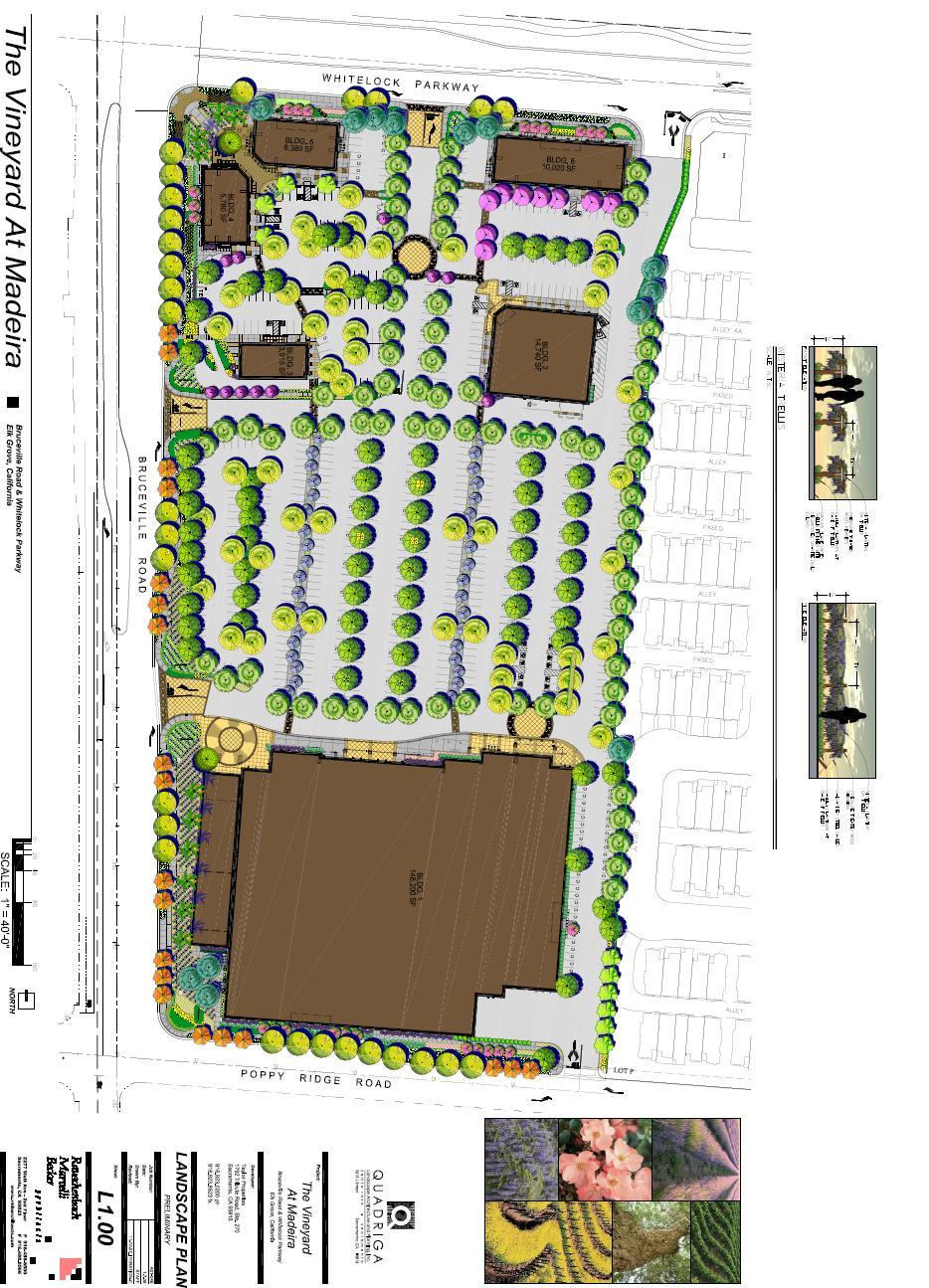
1 Owner/Applicant Taylor Village Sacramento Investments Partners, LP c/o Kim Whitney 1792 Tribute Road #270 Sacramento, CA Staff Recommendation Planning Commission Staff Report Project: File: Request: Vineyard at Madeira EG Specific Plan Amendment, Rezone, Tentative Parcel Map, Conditional Use Permit, and Design Review Location: Southeast corner of Bruceville Road and Whitelock Parkway APN: APN and Planner: Ron Rowland Recommend that the City Council approve the Specific Plan Amendment, Rezone, Tentative Parcel Map, Conditional Use Permit and Design Review, subject to the findings presented in this report and the attached Conditions of Approval. Project Description The proposed development is a shopping center. The anchor tenant would be Target. Other known tenants are Walgreen s and McDonalds. The proposed development includes a total of 189,035 square feet of retail floor area, which includes: Retail Use Target 148,200 Walgreen s 14,740 McDonald s 3,915 Multi-tenant Building 5,780 Multi-tenant Building 6,380 Multi-tenant Building 10,020 Floor Area (sq. ft.) The entitlements requested by the applicant consist of the following: 1. Minor amendment to the Laguna Ridge Specific Plan; 2. Rezone of approximately 2.7 acres from Medium Density Residential (RD-15) to Shopping Commercial (SC); 3. Tentative Parcel Map to subdivide acres of land into six commercial parcels; 4. Conditional Use Permit to allow a Retail Discount Store (Target) and to allow Drive-Thru Services for a proposed businesses within 300 feet of residentially zoned property(walgreens); and 5. Design Review for the proposed development, including a 10% reduction in the number of required parking spaces for the Target store and approval of a Uniform Sign Program.
2 Page 2 Setting This project site is vacant land located in an area that is designated by the Laguna Ridge Specific Plan for Shopping Commercial and High Density Residential uses. The Shopping Commercial (SC) designation is intended to provide for major shopping centers featuring retail and service commercial uses, which are dependent on vehicular access and visibility from arterial streets. The project site is surrounded by a variety of uses including existing residential subdivisions, vacant property previously approved for residential development (Zgraggen Ranch), and commercial developments. Table 1 below shows the uses adjacent to the project site: Table 1. Adjacent Land Designations and Uses Existing Uses General Plan Zoning Project Site Vacant Commercial/High Density Residential LRSP SC & RD-15 North Residential Low Density Residential LRSP - RD- 6 South Agricultural-Residential High Density Residential LRSP Multi- Family Residential West Commercial Shopping Center/Residential East Zgraggen Ranch Subdivision - Undeveloped Commercial/Office/Multi- Family & Low Density Residential High Density Residential East Franklin Specific Plan LRSP RD- 15 The project site is bounded by proposed arterial roadways which will accommodate cross-town traffic. The Circulation Plan for the Laguna Ridge Specific Plan calls for Bruceville Road to be expanded from a 2-lane roadway to a 4-lane roadway. Additional land in within the Bruceville Road right-of-way will be reserved by a 36-foot median and a 36-foot landscape corridor. This land could be used to expand Bruceville Road into a 6-lane thoroughfare, as identified in the General Plan, if needed in the future. Whitelock Parkway is planned as a four lane arterial roadway.

3 Page 3 Figure 1 - Location Map VINTAGE PARK DR. PROJECT SITE

4 Page 4 Analysis Specific Plan Amendment/Rezone The southeast corner of Bruceville Road and Whitelock Parkway was originally planned as a smaller shopping center, anchored by a grocery store. When it become apparent that market conditions would not support a grocery store at this location, the property owner considered other types of retail uses. The proposed Target store is substantially larger than a typical grocery store, requiring additional site area. The City has approved a lot line adjustment that transfers the 2.7 acre portion of Zgraggen Ranch to the parcel of land owned by Taylor Development. The Boundary Line adjustment does not affect the land use designations for these lands. A Specific Plan Amendment and a rezoning are required to change the designation of the 2.7 acres from RD-15 to the SC land use designation. Figure 2 Specific Plan Amendment/Rezone

5 Page 5 Tentative Parcel Map The property currently contains gross acres. Approximately 3.65 acres will be dedicated to the City as right-of-way, to accommodate improvements to Whitelock Parkway and Bruceville Road. The map calls for improvements to Bruceville Road and Poppy Ridge Road along the property s frontage. These improvements and right-of-way dedications are consistent with the City s General Plan and the Laguna Ridge Specific Plan. The Tentative Parcel Map would subdivide the project site into six lots. The lot with the Target store is acres. The remaining five lots range in size from 1.60 to 0.87 acres. As required by the City s Design Guidelines, the tentative parcel map provides landscape easements along its frontage with Bruceville Road (36-foot width) and Whitelock Parkway (25-foot width). Within these landscape corridors are 7-foot wide detached sidewalks. As required by the Laguna Ridge Specific Plan, the map provides reciprocal access, parking and utility easements among all parcels.
6 Page 6 Design Review The City Council adopted citywide Design Guidelines in 2003 and amended them in They address site planning and architecture for non-residential development. The design concepts endorsed by the Design Guidelines include: 1. Design compatibility with adjacent properties, particularly when non-residential abuts residential uses 2. Unified design theme 3. Pedestrian-friendly 4. Streetscape with appealing and continuous theme The applicant has submitted a detailed and comprehensive design review application, in a bound document provided to the Planning Commission. A summary of how the application complies with the key concepts of the Design Guidelines follows. Design Compatibility. The project abuts residentially zoned land along its eastern property line. The development plan provides for a 10-foot wide landscape corridor plus a masonry wall that varies from 6 to 8 feet in height. There is a 70-foot setback from the nearest building (Target) to the residential land. The combination of landscaping, wall and building setback will provide adequate compatibility. Unified Design Theme. The project offers a palette of colors, materials and design features that provide a good balance between variety and continuity. There is a broad range of colors and materials that gives visual interest. Those colors and materials are repeated in different combinations on all buildings. Pedestrian-friendly. As noted previously, the project will provide 7-foot wide sidewalks along Bruceville Road and Whitelock Parkway and a 4-foot wide sidewalk along Poppy Ridge Road. The plan provides strong pedestrian connections from the public sidewalks into the site. In addition, there is an internal pedestrian system, through the parking lot areas, connecting all buildings. Streetscape Theme. The site plan provides a strong streetscape theme through a unified planting palette, lighting standards, color and textured paving, trellises and other ornamental amenities. A sampling of the exhibits contained in the application submittal is provided below.
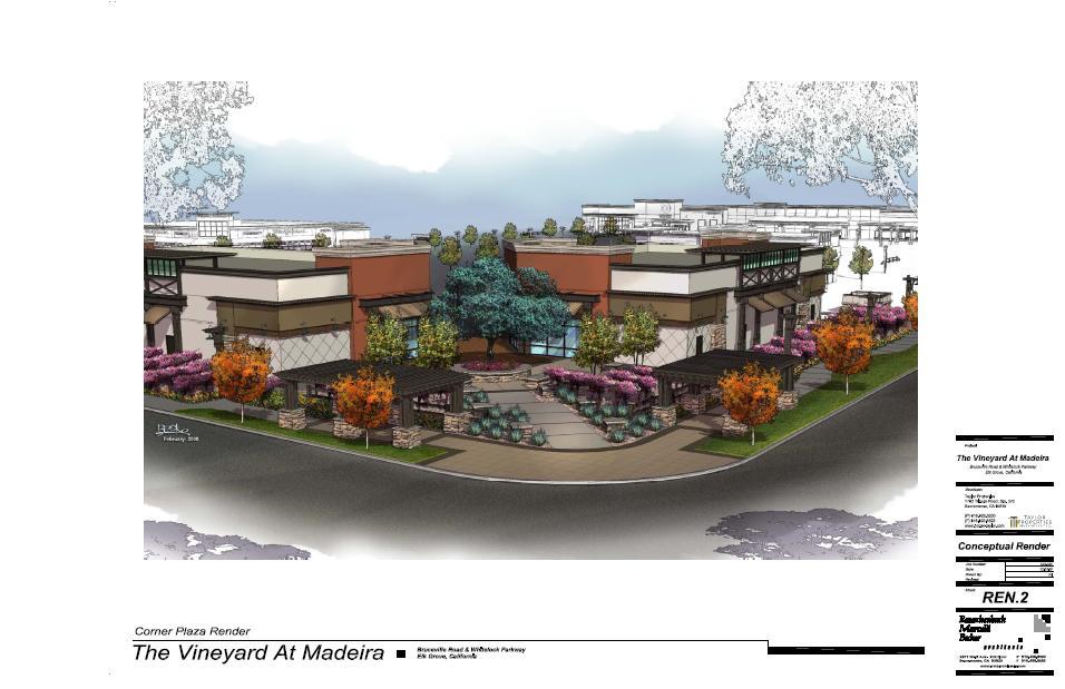
7 Page 7
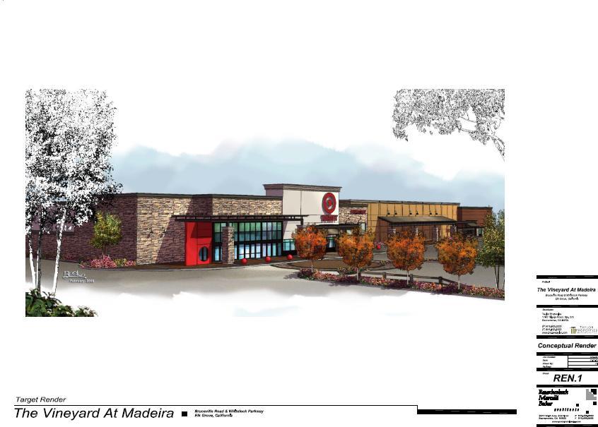
8 Page 8
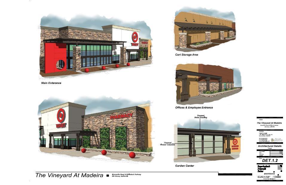
9 Page 9
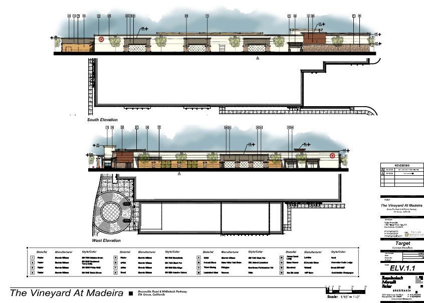
10 Page 10

11 Page 11 Specific site planning issues are addressed below. Compliance with Parking Standards. The zoning ordinance requirement for the shopping center is 873 parking spaces. A total of 803 spaces are provided. The applicant has requested a 10% reduction in the parking requirements for the Target store parcel. This would result in a reduction of about 8% below the standard for the shopping center as a whole. The zoning code allows the Planning Commission to approve a reduction in the number of required parking spaces. The specific finding applicable to this request is: Off-street vehicle parking reductions may also be granted when the applicant for a single or combined use can prove to the designated Approving Authority that the nature of the proposed use(s) or the proximity of the facility to alternative modes of transportation justify the requested parking reduction. This Chapter includes shared parking reductions due to variation in peak demands. Staff supports the requested reduction in parking for the following reasons: 1. The shopping center has multiple tenants in six different buildings; each tenant will have different peak parking demands.
12 Page The Target store has an approximate 10,800 square foot garden center. The parking demand for this portion of the building is less than the remainder and is somewhat seasonal in nature. 3. The site is served by alternate methods of transportation: a. Transit service is available on both Bruceville Road and Whitelock Parkway b. Pedestrian/bicycle path will be constructed along the north side of Whitelock Parkway as part of the Laguna Ridge development. 4. An 8% reduction in the number of parking spaces is not substantial for a shopping center of this size. Building Setbacks and Height. For commercial buildings in the Laguna Ridge Specific Plan, setbacks are determined through Design Review. The following setbacks are provided along the perimeter of the site: Property Line Setback (feet) Whitelock Parkway 25 Bruceville Road 36 Poppy Ridge Road 25 Eastern Property line 10 The Big Box retail standards would typically require a 35-foot rear yard setback. The Target store has an approximate 27-foot setback from Poppy Ridge Road at its closest point. However, this setback is more than 35 feet for a substantial length of the frontage. In addition, the applicant is required to provide a denser planting of trees along this frontage. These setbacks are adequate to provide streetscape landscaping and to ensure compatibility with adjacent residential uses. LRSP establishes a maximum height of 36 feet when a building is within 100 feet of a residential property. All buildings comply with this standard. Maximum height of Target building is 34.5 feet and the Walgreens building is feet. Circulation The development plan provides an adequate number of driveways onto the abutting public streets. There are two points of vehicular access to Bruceville Road, two driveways onto Whitelock Parkway and one driveway onto Poppy Ridge Road. The applicant will be required to dedicate and improve the easterly half of Bruceville Road, creating four travel lanes along the property s frontage and to construct Poppy Ridge Road improvements. At this time, Bruceville Road will not continue as a four lane road south of the project site, so the applicant is required to install interim striping on the road, which will provide a smooth and safe transition from a 4 lane to a 2 lane road. Landscaping The Zoning Code provides commercial landscape standards for landscaping along public frontages as well as within parking lots. The code requires a project to provide 50% parking lot
13 Page 13 shading within 15 years of tree maturity. Based on the calculations provided on a conceptual landscape plan, the site provides 58% shading, in compliance with the City s landscaping provision. The project also provides landscaping along the project frontages, ranging in width from 25 to 36 feet. A major focal point is proposed at the intersection of Bruceville Road and Whitelock Parkway. Key elements include: Trellises that match others in the LRSP area Colored and stamped concrete paving Seating area Specimen tree The exhibit which follows shows the preliminary landscape plan for the site. Other, more detailed plans are provided in the submittal packet.
14 Page 14

15 Page 15 Uniform Sign Program The Design Review package submitted by the applicant includes a Uniform Sign Program ( USP ). The USP provides a unified theme for signage throughout the shopping center program. The submittal includes several deviations from the sign regulations in the Zoning Ordinance. Those deviations are identified in the table below: Sign Type Code Requirement Request Target Monument Sign Area 150 sq ft 188 sq ft Wall Sign Area (total) 150 sq ft sq ft Walgreen s Wall Sign Area (total) 150 sq ft sq ft Future Tenants Wall Sign Ratio (area to frontage) 1:1 ratio 2:1 ratio Freestanding Sign Number of signs 1 sign 4 signs

16 Page 16 Environmental Analysis Staff has prepared an Initial Study pursuant to the California Environmental Quality Act ( CEQA ). The study concluded that the environmental impacts of the project have been addressed in the previously prepared Environmental Impact Report for Laguna Ridge Specific Plan. Therefore, the determination is that the project is exempt from CEQA pursuant to Section Letters from Commenting Agencies Letters have been received from the following city departments and agencies: City of Elk Grove Public Works Landscape Architect Police Finance Other Agencies
17 Page 17 Sacramento Area Sewer District Cosumnes Community Services District: Fire Summary Staff finds that the project exhibits a high quality architectural and landscape design. While certain deviations from standards are recommended, the overall quality of the project exceeds expectations. Recommended Motions 1. I move that the Planning Commission recommend to the City Council that the Laguna Ridge Specific Plan Amendment, Rezone, Tentative Parcel Map, Conditional Use Permit and Design Review (EG ) be approved, subject to the attached findings and conditions of approval contained in the staff report. Findings CEQA 1. Finding: The project is exempt from further CEQA review pursuant to Section of the State CEQA Guidelines. Evidence: As described in this staff report, the City has previously prepared an EIR for the Laguna Ridge Specific Plan (SCH # ). City staff has completed an Initial Study, which compared the environmental impacts of the project to those assessed in the prior EIR. The Initial Study finds that there are no new environmental impacts and that therefore the project is exempt from further CEQA review pursuant to Section of the State CEQA Guidelines. The property is included in the Mitigation Monitoring and Reporting Program ( MMRP ) for the Laguna Ridge Specific Plan EIR. General Plan Finding: The project is consistent with the goals and policies of the Elk Grove General Plan. Evidence: The General Plan designates the land at the southeast corner of Bruceville Road and Whitelock Parkway for commercial land uses. In addition, the site is within the Laguna Ridge Policy Plan, which has a specific set of policies (LU-28 through LU-31) and land use diagram (Figure 5) for the area. General Plan Policy LU-28 states that the land uses within Laguna Ridge Policy Area shall conform to the general layout of land uses shown in Figure LU-5. Given the inherent diagrammatic nature of the General Plan Land Use Map and Policy LU -28, we find that the change in land use designation of 2.7 acres is consistent with the General Plan as a whole.
18 Page 18 Tentative Parcel Map Finding: Section of the California Subdivision Map Act requires a City to deny approval of a tentative parcel map if it makes any of the following findings: a. That the proposed map is not consistent with applicable general and specific plans as specified in Section b. That the design or improvement of the proposed subdivision is not consistent with applicable general and specific plans. c. That the site is not physically suitable for the type of development. d. That the site is not physically suitable for the proposed density of development. e. That the design of the subdivision or the proposed improvements is likely to cause substantial environmental damage or substantially and avoidably injure fish or wildlife or their habitat. f. That the design of the subdivision or type of improvements is likely to cause serious public health problems. g. That the design of the subdivision or type of improvements will conflict with easements acquired by the public at large, for access through or use of, property within the proposed subdivision. Evidence: The above Findings #a. through #g. do not apply to the proposed Tentative Parcel Map. a. The proposed map is consistent with the Elk Grove General Plan as noted above. The proposed map is consistent with the Laguna Ridge Specific Plan, as amended. The design and improvement of the proposed subdivision is consistent with the General Plan in that it divides the site for commercial development. b. The design or improvement of the proposed subdivision for commercial development is consistent with the General Plan and Laguna Ridge Specific Plan. The required road improvements and right-of-way dedication is consistent with the Circulation Element of the General Plan and the Circulation Plan for Laguna Ridge Specific Plan. c. The site is physically suitable for commercial development in that it is a flat site with access to two arterial streets. d. The Laguna Ridge Specific Plan Environmental Impact Report determined that potential environmental impacts from the design of the subdivision or the proposed improvements will be mitigated to less than significant levels with implementation of the proposed Mitigation Measures and Conditions of Approval, and that a Statement of Overriding Considerations will be adopted by the City Council for those impacts that cannot be mitigated to less than significant levels. e. The Environmental Impact Report prepared for the project determined that no potentially serious health problems were identified from the project. f. No conflict with easements acquired by the public at large, for access through or use of property within the proposed subdivision has been identified. Rezone
19 Page 19 Finding: The proposed rezone is consistent with the General Plan commercial land use designation. Evidence: The Planning Commission has reviewed the proposed rezone, staff report, and has received public testimony at a duly noticed public hearing regarding the matter. The applicant s proposal is consistent with the allowed density and intensity of uses for commercial purposes in the Elk Grove General Plan and General Plan Land Use Map, as proposed for approval by the City Council. The proposed amendment is consistent with the Plan s objectives of orderly and systematic development and responds to opportunities and constraints in the local community area. Laguna Ridge Specific Plan Amendment Finding: The findings to approve an amendment to the Specific Plan are as follows: a. Significant changes to the character of the community have occurred subsequent to the adoption of the Specific Plan which warrants amendments as requested; b. The requested amendment would benefit the Specific Plan Area and/or the City; c. The amendment is consistent with the General Plan; d. The amendment will not adversely affect adjacent property owners and can be property serviced; e. Where applicable, the physical constraints of the property area are such that the requested amendment is warranted. Evidence: a. The area and configuration of the existing commercial land use designation was predicted on an assumed development of a shopping center anchored by a grocery store. Market conditions have demonstrated that a grocery store is not feasible. A larger commercial site is needed to accommodate a larger retail anchor tenant. b. The amendment benefits the Specific Plan Area and the City by providing retail services at a location convenient to residents of the area, reducing the need to drive greater distances. The commercial development will provide additional jobs and sales tax revenue to the city. c. The amendment is consistent with the General Plan, as described previously in the staff report. d. The amendment will not adversely affect adjacent property owners. Compatibility with adjacent uses is provided through a combination of building setbacks, walls, and perimeter landscaping. The conditions of approval ensure that adequate public utilities will be provided to the development. e. The amendment is not based on physical constraints but based on highest and best land use for the site.
20 Page 20 Design Review Finding: The proposed project is consistent with the City-wide Design Guidelines pertaining to site planning for non-residential development. Evidence: The project site plan has been reviewed in accordance with the provisions of the Citywide Design Guidelines for non-residential projects. It is concluded that the proposed design of the project meets the applicable design requirements, and that the proposed deviations are appropriate in the context of the project as a whole. Attachments 1. Conditions of Approval 2. Agency Correspondence 3. Application Submittals (separate bound document) 4. Boundary Line Adjustment EG
21 Page 21
Planning Commission Staff Report March 15, 2007
 Planning Commission Staff Report Project: Request: Madeira East Tentative Subdivision Map, Design Review for Subdivision Layout & Abandonment of Easements Location: Phase IV of the Laguna Ridge Specific
Planning Commission Staff Report February 19, 2009
 Planning Commission Staff Report February 19, 2009 Project: Warda Warehouse File: EG-08-051 Request: Design Review Location: 9260 Bendel Place APNs: 134-0660-004 Planner: Gerald Park Property Owner/Applicant
SPECIFIC PLAN Requirements
 CITY OF LANCASTER PLANNING DEPARTMENT 44933 Fern Avenue, Lancaster, California 93534 (661) 723-6100 SPECIFIC PLAN Requirements Purpose The purpose of a specific plan is to provide for the logical development
PC RESOLUTION NO
 PC RESOLUTION NO. 14-01-14-02 TENTATIVE TRACT MAP fttm) 17441. REZONE {RZ) 13-003, ARCHITECTURAL CONTROL (AC) 13-003, TREE REMOVAL PERMIT (TRP) 13-052. GRADING PLAN MODIFICATION (GPM) 13-002. CONDITIONAL
Planning Commission Staff Report February 5, 2015
 Planning Commission Staff Report Project: 99 Cents Only Store File: EG-14-018 Request: General Plan Amendment, Rezone, and Design Review Location: 8945 Brown Road; northeast corner of Elk Grove-Florin
Glenborough at Easton Land Use Master Plan
 Implementation 114 9.0 IMPLEMENTATION 9.1 OVERVIEW This chapter summarizes the administrative procedures necessary to implement the proposed land use plan, infrastructure improvements, development standards,
I Street, Sacramento, CA
 REPORT TO PLANNING COMMISSION City of Sacramento 12 915 I Street, Sacramento, CA 95814-2671 To: Members of the Planning Commission PUBLIC HEARING March 10, 2011 Subject: El Dorado Savings Sign Variance
12 January 12, 2011 Public Hearing APPLICANT: TAILWIND DEVELOPMENT GROUP,LLC PROPERTY OWNER: CITY OF VIRGINIA BEACH
 12 January 12, 2011 Public Hearing APPLICANT: TAILWIND DEVELOPMENT GROUP,LLC PROPERTY OWNER: CITY OF VIRGINIA BEACH STAFF PLANNER: Faith Christie REQUEST: Conditional Change of Zoning (from PD-H1 Planned
R E S O L U T I O N. Single-Family Residence/ Church. 2,488 sq. ft. 2,488 sq. ft. Area Parking Required: Church
 R E S O L U T I O N WHEREAS, the Prince George s County Planning Board is charged with the approval of Detailed Site Plans pursuant to Part 3, Division 9 of the Zoning Ordinance of the Prince George s
CHAPTER SPECIAL PURPOSE AND OVERLAY ZONING DISTRICTS
 Special Purpose and Overlay Zoning Districts 106.28.010 CHAPTER 106.28 - SPECIAL PURPOSE AND OVERLAY ZONING DISTRICTS SPECIAL PURPOSE AND OVERLAY ZONING DISTRICTS Sections: 106.28.010 - Purpose 106.28.020
14 October 10, 2012 Public Hearing APPLICANT: MPB, INC
 14 October 10, 2012 Public Hearing APPLICANT: MPB, INC PROPERTY OWNER: MUNDEN & ASSOCIATES, LP STAFF PLANNER: Karen Prochilo REQUEST: Conditional Change of Zoning (AG-1 & AG-2 to Conditional O-2) ADDRESS
Land Use element LAND USE POLICY AREAS ESTATE AND RURAL RESIDENTIAL AREAS/RURAL SHELDON AREA OLD TOWN ELK GROVE
 Land Use element Land Use is often considered the heart of the General Plan. The statement of future land uses describes how the City believes it should develop in the future where housing, shopping, open
8 February 9, 2011 Public Hearing APPLICANT: 7-ELEVEN, INC.
 . 8 February 9, 2011 Public Hearing APPLICANT: REQUEST: Conditional Use Permit for an automobile service station with a convenience store ADDRESS / DESCRIPTION: 2448 Nimmo Parkway PROPERTY OWNER: COURTHOUSE
AWH REPORT OF THE PLANNING AND DEVELOPMENT DEPARTMENT FOR APPLICATION FOR REZONING ORDINANCE TO PLANNED UNIT DEVELOPMENT
 AWH REPORT OF THE PLANNING AND DEVELOPMENT DEPARTMENT FOR APPLICATION FOR REZONING ORDINANCE TO PLANNED UNIT DEVELOPMENT MAY 8, 2014 The Planning and Development Department hereby forwards to the Planning
PLANNED DEVELOPMENT (MASTER PLAN & UNIT PLAN)
") Central Permit Center 555 Santa Clara Street Vallejo CA 94590 Business License Building Fire Prevention Planning Public Works 707.648.4310 707.648.4374 707.648.4565 707.648.4326 707.651.7151 PLANNED DEVELOPMENT
Central Permit Center 555 Santa Clara Street Vallejo CA 94590 Business License Building Fire Prevention Planning Public Works 707.648.4310 707.648.4374 707.648.4565 707.648.4326 707.651.7151 PLANNED DEVELOPMENT
CITY OF KEIZER MASTER PLAN APPLICATION & INFORMATION SHEET
 CITY OF KEIZER MASTER PLAN APPLICATION & INFORMATION SHEET PRE-APPLICATION CONFERENCE Prior to the actual filing of a Master Plan application, it is strongly recommended that the applicant contact Planning
PLANNED UNIT DEVELOPMENT Date: April 5, 2018
 PLANNED UNIT DEVELOPMENT Date: April 5, 2018 DEVELOPMENT NAME SUBDIVISION NAME LOCATION Robert Myers Robert Myers 2955 and 2989 Dauphin Street (Southeast corner of Dauphin Street and Sage Avenue) CITY
Land Use Element. policy areas are discussed in this Element:
 Land Use Element Land Use is often considered the heart of the General Plan. The statement of future land uses describes how the City believes it should develop in the future where housing, shopping, open
RESIDENTIAL PLANNED UNIT DEVELOPMENT / SUBDIVISION AND REZONING CONCEPT AND DEVELOPMENT STAGE PLAN SUBMITTAL NARRATIVE
 RESIDENTIAL PLANNED UNIT DEVELOPMENT / SUBDIVISION AND REZONING CONCEPT AND DEVELOPMENT STAGE PLAN SUBMITTAL NARRATIVE DEVELOPMENT TEAM DONEGAL SOUTH Maple Grove, Minnesota March 27, 2017 Applicant/Developer/Builder:
CITY OF VACAVILLE PLANNING COMMISSION Agenda Item No. G.3 STAFF REPORT August 18, 2015 Staff Contact: Peyman Behvand (707)
") CITY OF VACAVILLE PLANNING COMMISSION Agenda Item No. G.3 STAFF REPORT August 18, 2015 Staff Contact: Peyman Behvand (707) 449-5140 TITLE: REQUEST: VISTA CROSSINGS PLANNED SIGN PROGRAM AMENDMENT PLANNED
CITY OF VACAVILLE PLANNING COMMISSION Agenda Item No. G.3 STAFF REPORT August 18, 2015 Staff Contact: Peyman Behvand (707) 449-5140 TITLE: REQUEST: VISTA CROSSINGS PLANNED SIGN PROGRAM AMENDMENT PLANNED
VANDEN MEADOWS SPECIFIC PLAN TABLE OF CONTENTS Page 1.0 INTRODUCTION SUMMARY Schools Foxboro Parkway
 0 VANDEN MEADOWS SPECIFIC PLAN TABLE OF CONTENTS Page 1.0 INTRODUCTION 6 1.1. SUMMARY 6 1.1.1. Schools 11 1.1.2. Foxboro Parkway 11 1.1.3. Improvements to Leisure Town Road 11 1.1.4. New Neighborhood Park
Request Conditional Use Permit (Automobile Repair Garage) Staff Planner Kevin Kemp
 Staff Planner Kevin Kemp") Request Conditional Use Permit (Automobile Repair Garage) Staff Planner Kevin Kemp Location 845 Lynnhaven Parkway GPIN 14963473030000 Election District Rose Hall Site Size 0.40 acre portion of a 6.35 acre
Request Conditional Use Permit (Automobile Repair Garage) Staff Planner Kevin Kemp Location 845 Lynnhaven Parkway GPIN 14963473030000 Election District Rose Hall Site Size 0.40 acre portion of a 6.35 acre
Chapter PEDESTRIAN COMMERCIAL (PC) ZONING DISTRICT
 ZONING DISTRICT") Chapter 11-17 PEDESTRIAN COMMERCIAL (PC) ZONING DISTRICT Sections: 11-17-01 GENERAL PURPOSE 11-17-02 PERMITTED BUILDING TYPES 11-17-03 USES PERMITTED WITH DESIGN REVIEW 11-17-04 USES PERMITTED BY CONDITIONAL
Chapter 11-17 PEDESTRIAN COMMERCIAL (PC) ZONING DISTRICT Sections: 11-17-01 GENERAL PURPOSE 11-17-02 PERMITTED BUILDING TYPES 11-17-03 USES PERMITTED WITH DESIGN REVIEW 11-17-04 USES PERMITTED BY CONDITIONAL
VANDEN MEADOWS SPECIFIC PLAN TABLE OF CONTENTS Page 1.0 INTRODUCTION SUMMARY Schools Foxboro Parkway
 VANDEN MEADOWS SPECIFIC PLAN TABLE OF CONTENTS Page 1.0 INTRODUCTION 6 1.1. SUMMARY 6 1.1.1. Schools 11 1.1.2. Foxboro Parkway 11 1.1.3. Improvements to Leisure Town Road 11 1.1.4. New Neighborhood Park
MIDTOWN MIXED-USE VILLAGE. TECHNICAL DATA SHEET COMPONENT C-1 FOR PUBLIC HEARING - PETITION NUMBER Project No RZ1.1. Issued.
 N MIDTOWN MIXED-USE VILLAGE TECHNICAL DATA SHEET COMPONENT C- FOR PUBLIC HEARING - PETITION NUMBER 04-00 Project No. 496 Issued Revised SCALE: " = 0' N 0 0 0 40 RZ. c GENERAL PROVISIONS: a. SITE LOCATION.
7700 College Town Drive, Suite Ninth Street, Suite 212 Sacramento, CA Sacramento, CA 95814
 ACKNOWLEDGEMENTS/PROJECT TEAM: Property Owners Representative: The Hodgson Company John Lambeth 7700 College Town Drive, Suite 220 1025 Ninth Street, Suite 212 Sacramento, CA 95826 Sacramento, CA 95814
ELK GROVE TOWN CENTER DESIGN GUIDELINES
 ......... ELK GROVE TOWN CENTER DESIGN GUIDELINES LAGUNA RIDGE SPECIFIC PLAN... June 2008 ............ DESIGN GUIDELINES Table of Contents Contents Section A: Town Center Overview...1 A.1. Purpose and
Baumgarten MPUD. Exhibit 3 Evaluation Criteria
 Pursuant to LDC subsections 10.02.13 B, 10.02.08 F and Chapter 3 G. of the Administrative Code, staff s analysis and recommendation to the Planning Commission, and the Planning Commission s recommendation
Rezoning Petition Pre-Hearing Staff Analysis April 16, 2018
 Rezoning Petition 2018-015 Pre-Hearing Staff Analysis April 16, 2018 REQUEST LOCATION Current Zoning: R-4 (single family residential) and UR-2(CD) (urban residential, conditional) Proposed Zoning: UR-2(CD)
CITY OF VACAVILLE PLANNING COMMISSION Agenda Item No. G. 1 STAFF REPORT August 4, Staff Contact: Tricia Shortridge (707)
") CITY OF VACAVILLE PLANNING COMMISSION Agenda Item No. G. 1 STAFF REPORT August 4, 2009 Staff Contact: Tricia Shortridge (707) 449-5140 TITLE: REQUEST: LONGS / CVS DRIVE-THRU PHARMACY & REMODEL TIME EXTENSION
CITY OF VACAVILLE PLANNING COMMISSION Agenda Item No. G. 1 STAFF REPORT August 4, 2009 Staff Contact: Tricia Shortridge (707) 449-5140 TITLE: REQUEST: LONGS / CVS DRIVE-THRU PHARMACY & REMODEL TIME EXTENSION
PART 1: PROJECT SUMMARY. The application is Attachment A. The site plan is Attachment B.
 Belleterre Subdivision Sketch Plan Town Board 8.7.17 Belleterre Subdivision Sketch Plan PART 1: PROJECT SUMMARY Applicant: Bowman Development Project Size: +/- 20.85 acres Parcel Number: 01115104 and 01115121
Prepared by: Casey Kempenaar, Senior Planner
 CITY OF CITRUS HEIGHTS PLANNING DIVISION STAFF REPORT PLANNING COMMISSION MEETING September 13, 2017 Prepared by: Casey Kempenaar, Senior Planner REQUEST The applicant requests a Design Review Permit Modification
01 PROJECT DESCRIPTION
 01 PROJECT DESCRIPTION PROJECT LOCATION The proposed Barrett Ranch East project (the Project) site is in northern Sacramento County in the Antelope community, north of the intersection of Don Julio Boulevard
Planning Commission Staff Report May 31, 2007
 Planning Commission Staff Report Project: Elk Grove Promenade File: EG-05-878 Request: Development Plan Review Location: Approximately 107 acres located at the northwest corner of State Route 99 and Grant
4.0 LAND USE 4.1 EXISTING SETTING CITY OF ELK GROVE PROJECT AREA
 This section describes the existing and proposed land uses in the Project area, characterizes current and proposed surrounding land uses, and describes the land use designations according to the General
Urban Design Brief December 23, 2015 Southside Construction Group Official Plan & Zoning By-Law Amendment
 Urban Design Brief Proposed Official Plan & Zoning By-Law Amendment 3244, 3263 and 3274 Wonderland Road South Southside Group December 23, 2015 TABLE OF CONTENTS Page No. INTRODUCTION... 1 SECTION 1 LAND
Town of Portola Valley General Plan. Nathhorst Triangle Area Plan
 Town of Portola Valley General Plan Amended December 10, 1997 Table of Contents Introduction... 1 Planning Area... 1 Objectives... 2 Principles... 2 Standards... 4 Description... 4 Community Commercial...
Asbury Chapel Subdivision Sketch Plan
 Asbury Chapel Subdivision Sketch Plan PART 1: PROJECT SUMMARY Applicant: NVR Inc. Project Size: +/- 76.13 acres Parcel Numbers: 02101112,02116101,02116112, 02116113 Current Zoning: Transitional Residential
ARTICLE 6: Special and Planned Development Districts
 ARTICLE 6: Special and Planned Development Districts 6-10 Traditional Neighborhood Development (TND) District 6-10.10 Purpose and Intent The Traditional Neighborhood Development (TND) District provides
PLANNING COMMISSION. Submitted
 PLANNING COMMISSION City Hall 1275 Main Street El Centro, CA 92243 Submitted PLANNING COMMISSION ACTION ITEM (1844) Meeting: 05/10/16 12:00 AM Department: Community Development Category: Public Hearing
D1 September 11, 2013 Public Hearing APPLICANT:
 D1 September 11, 2013 Public Hearing APPLICANT: BEACH MUNICIPAL FEDERAL CREDIT UNION PROPERTY OWNER: SISTERS II, LLC STAFF PLANNER: Karen Prochilo REQUEST: Conditional Change of Zoning (AG-2 Agriculture
A BILL FOR AN ORDINANCE TO AMEND CHAPTER 9, KAUAI COUNTY CODE 1987, RELATING TO STREET REQUIRE:MENTS FOR SUBDIVISIONS
 ORDINANCE NO. BILL NO. { vy"yj1j A BILL FOR AN ORDINANCE TO AMEND CHAPTER 9, KAUAI COUNTY CODE 1987, RELATING TO STREET REQUIRE:MENTS FOR SUBDIVISIONS BE IT ORDAINED BY THE COUNCIL OF THE COUNTY OF KAUA'I,
Staff Planner Ashby Moss. Location 4752 Virginia Beach Boulevard GPIN Site Size acres AICUZ Less than 65 db DNL
 Applicant Property Owner POP Steakhouse, LLC Public Hearing November 9, 2016 City Council Election District Bayside Agenda Item 1 Request Alternative Compliance Special Exception for Alternative Compliance
VILLAGE OF CLEMMONS PLANNING BOARD DRAFT STAFF REPORT
 VILLAGE OF CLEMMONS PLANNING BOARD DRAFT STAFF REPORT PETITION INFORMATION Docket # C-226 Staff Megan Ledbetter Petitioner(s) JBJH Properties, LLC Owner(s) JBJH Properties, LLC Subject Property 5892-49-1766
Wake County Parcel Identification Number (PIN) (10-digit) Total Area 0.48
 (10-digit) Total Area 0.48") STAFF REPORT Town Council, September 3, 2015 Mom's Auto Care Site Plan 14-SP-035 (PL16-019) Conduct public hearing and consider action on proposed site plan request. Speaker: Douglas Loveland From: Jeff
STAFF REPORT Town Council, September 3, 2015 Mom's Auto Care Site Plan 14-SP-035 (PL16-019) Conduct public hearing and consider action on proposed site plan request. Speaker: Douglas Loveland From: Jeff
4.1.3 LAND USE CATEGORIES
 4.1.3 LAND USE CATEGORIES a. City Center District The City Center District incorporates the existing character and mix of uses in downtown Belmont to encourage redevelopment and new development in keeping
Rezoning Petition Zoning Committee Recommendation August 1, 2017
 Rezoning Petition 2017-090 Zoning Committee Recommendation August 1, 2017 REQUEST LOCATION SUMMARY OF PETITION PROPERTY OWNER PETITIONER AGENT/REPRESENTATIVE COMMUNITY MEETING STATEMENT OF CONSISTENCY
Future Five. Design/ Development Guidelines. January 2008 Amended June 08 per City Council motion
 Future Five Design/ Development Guidelines January 2008 Amended June 08 per City Council motion 5-Points Design Guidelines Table of Contents I. Introduction 3 II. Area boundaries 4 III. Review Process
DESIGN REVIEW COMMITTEE AGENDA ITEM
 DESIGN REVIEW COMMITTEE AGENDA ITEM AGENDA DATE: DECEMBER 16, 2015 TO: THRU: FROM: SUBJECT: Chair McCormick and Members of the Design Review Committee Leslie Aranda Roseberry, Planning Manager Kelly Christensen
CITY OF ALAMEDA PLANNING BOARD Draft RESOLUTION
 CITY OF ALAMEDA PLANNING BOARD Draft RESOLUTION A RESOLUTION OF THE PLANNING BOARD OF THE CITY OF ALAMEDA APPROVING DESIGN REVIEW AND DEVELOPMENT PLAN AMENDMENT APPLICATION PLN13-0157 TO CONSTRUCT ELEVEN
Narcoossee Roadway Corridor
 Community Meeting Narcoossee Roadway Corridor April 5, 2012 Meeting Agenda Purpose of Meeting Continuation of Study Update Process (Previous Meetings Oct. & Nov., 2011) Tonight s Objective Review Proposals
4780 Eglinton Avenue West - Zoning By-law Amendment and Draft Plan of Subdivision Applications - Preliminary Report
 STAFF REPORT ACTION REQUIRED 4780 Eglinton Avenue West - Zoning By-law Amendment and Draft Plan of Subdivision Applications - Preliminary Report Date: May 29, 2014 To: From: Wards: Reference Number: Etobicoke
PLANNED UNIT DEVELOPMENT & SUBDIVISION STAFF REPORT Date: May 18, 2017
 & PUD-0000102-2017 PLANNED UNIT DEVELOPMENT & SUBDIVISION STAFF REPORT Date: May 18, 2017 NAME SUBDIVISION NAME Dauphin Creek Estates Subdivision Dauphin Creek Estates Subdivision LOCATION CITY COUNCIL
Rezoning Petition Post-Hearing Staff Analysis July 31, 2018
 Rezoning Petition 2018-044 Post-Hearing Staff Analysis July 31, 2018 REQUEST Current Zoning: R-3 (single family residential) Proposed Zoning: UR-2(CD) (urban residential, conditional) LOCATION Approximately
NOTICE OF PREPARATION OF AN ENVIRONMENTAL IMPACT REPORT AND SCOPING MEETING FOR THE LAND PARK COMMERCIAL CENTER PROJECT
 NOTICE OF PREPARATION OF AN ENVIRONMENTAL IMPACT REPORT AND SCOPING MEETING FOR THE LAND PARK COMMERCIAL CENTER PROJECT PUBLIC COMMENT PERIOD November 12, 2015 to December 14, 2015 INTRODUCTION The City
CITY OF WILDOMAR CITY COUNCIL Agenda Item #2.1 PUBLIC HEARING Meeting Date: May 9, 2018
 CITY OF WILDOMAR CITY COUNCIL Agenda Item #2.1 PUBLIC HEARING Meeting Date: May 9, 2018 TO: FROM: Mayor and City Council Members Matthew Bassi, Planning Director SUBJECT: Wildomar Crossings Retail Center
Westwind Developments Ltd. PIONEER LANDS AREA STRUCTURE PLAN - PROPOSED AMENDMENT
 FEBRUARY 2013 TABLE OF CONTENTS 1.0 BACKGROUND... 1 1.1 Amendment... 1 2.0 LOCATION & CONTEXT... 2 2.1 Land Ownership... 2 3.0 POLICY CONTEXT... 3 3.1 Municipal Development Plan... 3 3.2 Capital Region
SUBDIVISION, PLANNED UNIT DEVELOPMENT, PLANNING APPROVAL, REZONING & SIDEWALK WAIVER STAFF REPORT Date: February 7, 2013
 SUBDIVISION, PLANNED UNIT DEVELOPMENT, PLANNING APPROVAL, REZONING & SIDEWALK WAIVER STAFF REPORT Date: February 7, 2013 APPLICANT NAME SUBDIVISION NAME DEVELOPMENT NAME LOCATION S. E. Cemeteries of AL
Gold Line Bus Rapid Transit Transit Oriented Development (BRTOD) Helmo Station Area Plan
 Helmo Station Area Plan") Appendix F Gold Line Bus Rapid Transit Transit Oriented Development (BRTOD) Helmo Station Area Plan Introduction and Purpose of the Plan The Gold Line Bus Rapid Transit facility is an eleven-mile dedicated
Appendix F Gold Line Bus Rapid Transit Transit Oriented Development (BRTOD) Helmo Station Area Plan Introduction and Purpose of the Plan The Gold Line Bus Rapid Transit facility is an eleven-mile dedicated
The Ritz-Carlton, Paradise Valley
 The Ritz-Carlton, Paradise Valley 7000 E. Lincoln Drive Keys to Success Community Conversation II June 4, 2015 RITZ-CARLTON PARADISE VALLEY Town Council Study Session June 4, 2015 General Plan 2012 Land
CITY COUNCIL STUDY SESSION MEMORANDUM
 City and County of Broomfield, Colorado CITY COUNCIL STUDY SESSION MEMORANDUM To: From: Prepared by: Mayor and City Council Charles Ozaki, City and County Manager Kevin Standbridge, Deputy City and County
Rezoning Petition Pre-Hearing Staff Analysis July 16, 2018
 Rezoning Petition 2018-044 Pre-Hearing Staff Analysis July 16, 2018 REQUEST Current Zoning: R-3 (single family residential) Proposed Zoning: UR-2(CD) (urban residential, conditional) LOCATION Approximately
Development Guidelines - Florin-Vineyard Community Plan Administrative Draft
 TABLE OF CONTENTS 1.0 INTRODUCTION... 1-1 1.1 Purpose and Intent... 1-1 1.2 Setting... 1-1 1.3 Land Use Summary... 1-3 2.0 RESIDENTIAL LAND USES... 2-1 2.1 Residential Densities... 2-1 2.2 Existing Neighborhood
ORDINANCE WHEREAS, this Ordinance is consistent with the City of Winter Garden Comprehensive Plan; and
 ORDINANCE 17-06 AN ORDINANCE OF THE CITY COMMISSION OF THE CITY OF WINTER GARDEN, FLORIDA, CREATING ARTICLE XIV OF CHAPTER 118 OF THE CITY OF WINTER GARDEN CODE OF ORDINANCES PROVIDING FOR THE EAST PLANT
McDonald s Restaurant - Purcellville Town of Purcellville Special Use Permit Statement of Justification July 24, 2014
 Introduction / Written Statement McDonald s Restaurant - Purcellville McDonald s Corporation is proposing to redevelop the existing McDonald s eating establishment with a drive-through located at 121 N
ELECTION DISTRICT: PRINCESS ANNE
 D3 April 10, 2013 Public Hearing APPLICANT: HOLLOMON- BROWN FUNERAL HOME, INC. PROPERTY OWNER: HOLLOMON- BROWN FUNERAL HOME, INC. & TIDEWATER CEMETERY CORP. STAFF PLANNER: Karen Prochilo REQUEST: Conditional
CHAPTER 2 SUMMARY 1. PROJECT SUMMARY DATA
 CHAPTER 2 SUMMARY This is an Initial Study format used to determine, pursuant to CEQA Guidelines Section 15177, whether a project 1) is within the scope of a Master EIR (MEIR), 2) may result in additional
4. INDUSTRIAL 53 CASTLE ROCK DESIGN
 4. INDUSTRIAL 53 CASTLE ROCK DESIGN CASTLE ROCK DESIGN 54 4. INDUSTRIAL Overview Well-designed and attractive industrial centers are the product of blending economic realities with both functional and
DESIGN REVIEW COMMITTEE AGENDA ITEM
 DESIGN REVIEW COMMITTEE AGENDA ITEM AGENDA DATE: OCTOBER 3, 2012 TO: Chair Woollett and Members of the Design Review Committee THRU: FROM: SUBJECT: Leslie Aranda Roseberry, Planning Manager Daniel Ryan,
Request Alternative Compliance to the prescribed criteria of the Oceanfront Resort District Form-Based Code. Staff Planner Kristine Gay
 Applicant/Owner Ocean Rental Properties, LLC Public Hearing April 13, 2016 City Council Election District Beach Agenda Item 1 Request Alternative Compliance to the prescribed criteria of the Oceanfront
CITY PLANNING COMMISSION AGENDA. ITEM NO(s): C.1 C.3 STAFF: STEVE TUCK
: C.1 C.3 STAFF: STEVE TUCK") Page 34 CITY PLANNING COMMISSION AGENDA ITEM NO(s): C.1 C.3 STAFF: STEVE TUCK FILE NOS: CPC ZC 12-00035 QUASI-JUDICIAL CPC NV 12-00036 QUASI-JUDICIAL AR DP 12-00039 QUASI-JUDICIAL PROJECT: APPLICANT: OWNER:
Page 34 CITY PLANNING COMMISSION AGENDA ITEM NO(s): C.1 C.3 STAFF: STEVE TUCK FILE NOS: CPC ZC 12-00035 QUASI-JUDICIAL CPC NV 12-00036 QUASI-JUDICIAL AR DP 12-00039 QUASI-JUDICIAL PROJECT: APPLICANT: OWNER:
Planning Commission Staff Report February 20, 2014
 Planning Commission Staff Report February 20, 2014 Project: Silverado Village File: EG-11-046 Request: Establishment of a Special Planning Area, Rezone, Tentative Subdivision Map, Major Design Review for
PLANNING COMMISSION AGENDA REPORT NOVEMBER 15, 2012
 PLANNING COMMISSION AGENDA REPORT NOVEMBER 15, 2012 TO: FROM: Members of the Planning Commission Michael Klein, Associate Planner FILE NO.: 120000890 PROPOSAL: APPLICANT: Request for an Administrative
#8) T-1409 CENTENNIAL & LAMB TENTATIVE MAP
 T-1409 CENTENNIAL & LAMB TENTATIVE MAP") #8) T-1409 CENTENNIAL & LAMB TENTATIVE MAP STAFF REPORT To: Planning Commission Meeting Date: June 14, 2017 Item: T-1409 Prepared By: Robert Eastman GENERAL INFORMATION: Applicant: Property Owner(s): Requested
#8) T-1409 CENTENNIAL & LAMB TENTATIVE MAP STAFF REPORT To: Planning Commission Meeting Date: June 14, 2017 Item: T-1409 Prepared By: Robert Eastman GENERAL INFORMATION: Applicant: Property Owner(s): Requested
EXHIBIT A. Chapter 2.7 SPECIAL PLANNED DISTRICTS. Article XVIII 15th Street School Master Planned Development
 EXHIBIT A Chapter 2.7 SPECIAL PLANNED DISTRICTS Article XVIII 15th Street School Master Planned Development Sections: 2.7.3600 15 th Street School Master Planned Development 2.7.3610 Purpose 2.7.3620 Definitions
Rapid City Planning Commission Rezoning Project Report
 Rapid City Planning Commission Rezoning Project Report April 5, 2018 Item # 4 Applicant Request(s) Case # 18RZ008 Rezoning request from General Agricultural District to Low Density Residential District
The transportation system in a community is an
 7 TRANSPORTATION The transportation system in a community is an important factor contributing to the quality of life of the residents. Without a sound transportation system to bring both goods and patrons
Request Conditional Rezoning (R-10 Residential & I-1 Light Industrial to Conditional I-1 Light Industrial) Staff Recommendation Approval
 Staff Recommendation Approval") Applicant & Property Owner Public Hearing January 9, 2019 City Council Election District Beach Agenda Item 1 Request Conditional Rezoning (R-10 Residential & I-1 Light Industrial to Conditional I-1 Light
Applicant & Property Owner Public Hearing January 9, 2019 City Council Election District Beach Agenda Item 1 Request Conditional Rezoning (R-10 Residential & I-1 Light Industrial to Conditional I-1 Light
Design Review Application *Please call prior to submittal meeting to determine applicable fees*
 CITY OF EAGLE 660 E. Civic Lane, Eagle, ID 83616 Phone#: (208) 939-0227 Fax: (208) 938-3854 Design Review Application *Please call prior to submittal meeting to determine applicable fees* FILE NO.: CROSS
5.1 Site Plan Guidelines
 5. Community Core Guidelines Development of the Community Core will take place by plan of subdivision and site plan approval. It will occur in a phased manner that will reflect the timing of residential
141 GEORGE STREET PLANNING RATIONALE
 141 GEORGE STREET PLANNING RATIONALE MINOR ZONING BY-LAW AMENDMENT NOVEMBER 2, 2016 PLANNING RATIONALE 223 McLeod Street Ottawa, ON K2P 0Z8 613.730.5709 fotenn.com INTRODUCTION FOTENN Consultants is acting
M E M O R A N D U M July 27, 2018
 M E M O R A N D U M July 27, 2018 To: Southlake 2035 Corridor Planning Committee From: Kenneth Baker, Sr. Director of Planning and Development Services Subject: Item #6 First National Bank Purpose Review,
Approved: CITY OF ARDEN HILLS, MINNESOTA PLANNING COMMISSION WEDNESDAY, AUGUST 5, :30 P.M. - ARDEN HILLS CITY HALL
 Approved: CITY OF ARDEN HILLS, MINNESOTA PLANNING COMMISSION WEDNESDAY, AUGUST 5, 2015 6:30 P.M. - ARDEN HILLS CITY HALL PLANNING CASES A. Planning Case 15-016; Final Planned Unit Development Arden Plaza;
PLANNING COMMISSION REPORT
 PLANNING COMMISSION REPORT REZONING CASE NO. RZ-14-002 REPORT DATE: February 10, 2015 CASE NAME: 9990 W. Alameda Ave. Rezoning PLANNING COMMISSION DATE: February 18, 2015 ADDRESS OF REZONING PROPOSAL:
PART 1: PROJECT SUMMARY. Proposed Land Use: 120 single-family lots. The application is Attachment A. The site plan is Attachment B.
 PART 1: PROJECT SUMMARY Applicant: JBH Development, LLC and Hopper Communities, INC Project Size: +/- 80.48 acres Parcel Number: 01513107, 01513108, 01513109, 01513113, 01513120, 01513121, 01513122, 01513124,
Planning & Zoning Commission Meeting Date: June 18, 2012
 Meeting Date: June 18, 2012 Request Applicant Owner Zoning Location Attachments Proposed Master Plan for 11.5 acres of undeveloped property in the Tuscan Lakes PUD. The land is platted as one lot, and
REPORT TO PLANNING AND DESIGN COMMISSION City of Sacramento
 REPORT TO PLANNING AND DESIGN COMMISSION City of Sacramento 5 PUBLIC HEARING June 12, 2014 To: Members of the Planning and Design Commission Subject: Newman Center Sign (P14-017) A request to construct
The Maryland-National Capital Park and Planning Commission Prince George s County Planning Department Development Review Division
 The Maryland-National Capital Park and Planning Commission Prince George s County Planning Department Development Review Division 301-952-3530 Note: Staff reports can be accessed at www.mncppc.org/pgco/planning/plan.htm.
6 July 9, 2014 Public Hearing
 6 July 9, 2014 Public Hearing APPLICANT: CAMERON JUSTIN MUNDEN PROPERTY OWNER: GRANTED WISH, L.L.C. STAFF PLANNER: Kevin Kemp REQUEST: Conditional Use Permit (Bulk Storage Yard) ADDRESS / DESCRIPTION:
Commercial Development Proposal Tenth Line Road. Planning Rationale Report. Minto Developments Inc.
 Commercial Development Proposal 2168 Tenth Line Road Report September 2015 Prepared for Minto Developments Inc. Paquette Planning Associates Ltd. 56 Hutchison Avenue Ottawa, Ontario K1Y 4A3 PH: 613-722-7217
CITY PLANNING COMMISSION AGENDA ITEM: C STAFF: ROBERT TEGLER FILE NO: CPC PUD QUASI-JUDICIAL
 CPC AGENDA June 8, 2006 Page 37 CITY PLANNING COMMISSION AGENDA ITEM: C STAFF: ROBERT TEGLER FILE NO: CPC PUD 05-294 - QUASI-JUDICIAL PROJECT: APPLICANT: OWNER: PARKWOOD AT WOLF RANCH NASS DESIGN ASSOCIATES
Major Subdivision Sketch Plan Checklist
 This checklist provides specific requirements that are apart of the Sketch process. The entire process is described by the Huntersville Subdivision Review Process which details all the submittal and resubmittal
CASE NUMBER: 16SN0701 APPLICANT: Hanky, LLC
 STAFF S ANALYSIS AND RECOMMENDATION Planning Commission (CPC) Public Hearing Date: MAY 17, 2016 CPC Time Remaining: 100 DAYS Applicant s Agent: DANIEL L. CASKIE (804-569-7060) Applicant s Contact: MICHAEL
CITY OF ELK GROVE CITY COUNCIL STAFF REPORT
 CITY OF ELK GROVE CITY COUNCIL STAFF REPORT AGENDA TITLE: A public hearing to consider the Elk Grove Promenade Development Plan Review, Project EG-05-878 MEETING DATE: PREPARED BY: Jessica Shalamunec,
Request for Decision. Recommendation. Presented: Monday, Jul 07, Report Date Friday, Jun 20, Type: Public Hearings
 Presented To: Planning Committee Request for Decision Application for rezoning in order to permit a place of worship on a vacant lot zoned for C1, Local Commercial uses, Cam Street, Sudbury Sitiri Investments
10 October 14, 2015 Public Hearing
 10 October 14, 2015 Public Hearing APPLICANT: PROPERTY OWNER: VIRGINIA BEACH BEACON BAPTIST CHURCH STAFF PLANNER: Stephen J. White REQUESTS: A. Change of Zoning (R-20 Residential District to Conditional
East Panorama Ridge Concept Plan Amendment
 Page 1 of 7 L003 : East Panorama Ridge Concept Plan Amendment Corporate NO: L003 Report COUNCIL DATE: March 4, 2002 REGULAR COUNCIL LAND USE TO: Mayor & Council DATE: February 27, 2002 FROM: General Manager,
REZONING APPLICATION MPD SUPPLEMENT
 REZONING APPLICATION MPD SUPPLEMENT For Staff Use Only: DATE/TIMESTAMP: ZA# RECEIVED BY: The intent of the Master Planned District (MPD) designation is to allow flexibility in the design and construction
TOP TEN LIST OF COMMUNITY CONCERNS REGARDING PROPOSED AMENDMENTS TO CHAPTER 42
 TOP TEN LIST OF COMMUNITY CONCERNS REGARDING PROPOSED AMENDMENTS TO CHAPTER 42 1. Extend the urban area to Beltway 8 in stages, over say a three-year period, prioritizing development in transit and declining
CASE NUMBER: 16SN0565 (AMENDED) APPLICANT: C.A.H. Investments, LLC
 APPLICANT: C.A.H. Investments, LLC") CASE NUMBER: 16SN0565 (AMENDED) APPLICANT: C.A.H. Investments, LLC STAFF S ANALYSIS AND RECOMMENDATION Board of Supervisors (BOS) Public Hearing Date: JUNE 22, 2016 BOS Time Remaining: 365 DAYS Applicant
CASE NUMBER: 16SN0565 (AMENDED) APPLICANT: C.A.H. Investments, LLC STAFF S ANALYSIS AND RECOMMENDATION Board of Supervisors (BOS) Public Hearing Date: JUNE 22, 2016 BOS Time Remaining: 365 DAYS Applicant