PROPOSED AUCKLAND UNITARY PLAN, PART 2 - REGIONAL AND DISTRICT OBJECTIVES AND POLICIES, CHAPTER F: PRECINCT OBJECTIVES AND POLICIES, 6: SOUTH
|
|
|
- Doris Perkins
- 5 years ago
- Views:
Transcription

1 1 PROPOSED AUCKLAND UNITARY PLAN, PART 2 - REGIONAL AND DISTRICT OBJECTIVES AND POLICIES, CHAPTER F: PRECINCT OBJECTIVES AND POLICIES, 6: SOUTH 6.15: Mangere Gateway The objectives and policies of the underlying Mixed Housing Suburban zone and Auckland-wide rules apply in the following precinct unless otherwise specified. Refer to the planning maps for the location and extent of the precinct. Precinct description The description of the Mangere Gateway Precinct applies except for the amendments specified below: The underlying zone for sub-precincts A, B and C is Light Industry, sub-precinct D is Future Urban and for sub-precinct E the underlying zone is Mixed Housing Suburban. And: Sub-precinct E This sub-precinct covers the Mixed Housing Suburban areas located adjacent to the Otuataua Stonefields Historic Reserve. Sub-precinct E is comprised of 33 hectares of land located on the Ihumātao Peninsula, bound to the east by Oruarangi Road and to the west by the Otuataua Stonefields reserve. The Auckland International Airport is located approximately 2.5km to the south of the sub-precinct E area. The purpose of the sub-precinct is to provide for comprehensive and integrated residential development to increase the supply of housing (including affordable housing), and to encourage the efficient use of land and the provision of infrastructure. The sub-precinct will provide for a residential area that will be integrated with key road links, areas of public open space, and provide a range of housing options. Development in the sub-precinct is intended to respect the significant cultural and heritage characteristics associated with the site and its surrounds while appropriately recognising and providing for the protection of the adjacent Otuataua Stonefields Historic Reserve and the Papakainga area. It is envisaged that future land use and subdivision resource consents will give effect to the key elements of the Mangere Gateway sub-precinct E sub-precinct plan to facilitate residential development in a co-ordinated manner. Sub-precinct E specific objectives The objectives are as listed in the underlying Mixed Housing Suburban zone and the Mangere Gateway precinct objectives, with additional objectives as specified below:
2 2 1. Subdivision and development occurs in a coordinated manner that gives effect to the Mangere Gateway sub-precinct E precinct plan. 2. Subdivision and development which responds appropriately to the varied external interfaces of the site, balancing the need for integration with the need to limit effects on sensitive adjacent areas and to discourage future extension of the development. 3. Subdivision and development respects the adjacent Otuataua Stonefields Historic Reserve area and provides for the protection of the remnant edges of the Pukeiti and Otuataua volcanic cones. 4. Subdivision and development recognises and provides for the existing cultural and heritage values of the site, in particular the adjacent Otuataua Stonefields Historic Reserve area and Maori cultural associations with the area, including wahi tapu. 5. Subdivision and development protects the visual amenity values of the Otuataua Stonefields Historic Reserve and in particular sightlines to the reserve and the Pukeiti Maunga from the existing Papakainga area. 6. Subdivision and development is set back from the existing Papakainga area to: a. Provide a buffer between the Papakainga properties and new dwellings; b. Achieve a functional and vegetated stormwater corridor to manage flooding and reduce flood effects on the Papakainga properties; and c. Allow Mana Whenua use of the buffer area for cultural practices and traditional medicinal and other plantings. 7. Subdivision and development occurs in a manner that achieves the coordinated delivery of infrastructure, including transport, stormwater, wastewater and water services. 8. Subdivision and development implements a stormwater management network that: a. Uses water sensitive design as a core development approach; b. Protects the ecological values of the receiving environment; c. Integrates with open space and road networks; d. Maintains the function of the existing overland flowpath in the sub-precinct through provision of a vegetated swale running south to north across the subprecinct. 9. Subdivision and development is integrated with the external road network and provides for the enhancement and improvement of Oruarangi Road where it immediately adjoins the sub-precinct.
3 3 10. Oruarangi Road and Ihumātao Quarry Road are recognised as key components of the Mangere Gateway Heritage Route and upgraded to reflect the unique character and identity of the area. 11. A safe, efficient, legible and low speed internal street movement network is provided in the sub-precinct. 12. A safe and convenient internal pedestrian and cycle network is provided with connections to adjacent public open space. 13. Opportunities for provision of an integrated public transport bus route to serve the local residential population and linking with the adjacent business and employment land and the Auckland International Airport are investigated. 14. Opportunities for recreation and social interaction are provided internal to the subprecinct and away from sensitive heritage and cultural sites. 15. Retention, restoration and adaptive use of heritage resources/features within the sub-precinct is provided for. 16. Subdivision and development occur in a manner that recognises the presence, ongoing operation, and national and regional importance of the Auckland International Airport. 17. Development provides for increased housing supply, variety and choice by creating a well-designed residential development comprised of a range of housing densities, typologies and affordable price options. 18. Subdivision and development provides opportunities for affordable housing relative to the local housing market in Mangere. 19. Landscaping of streets and public spaces that recognises site context and natural and cultural character. 20. To promote increased housing supply, variety and choice by creating welldesigned residential developments comprising a range of housing densities, typologies, and price options (including the provision of affordable housing). 21. To ensure that the affordable housing provided in any residential development is distributed throughout the location in which resource consent is sought. 22. To promote the availability of affordable housing to first home buyers and/or Community Housing Providers. Sub-precinct E specific policies The policies are as listed in the underlying Mixed Housing Suburban zone and Mangere Gateway policies, as well as those specified below:
4 4 1. Require structural elements of the Mangere Gateway sub-precinct E precinct plan to be incorporated into all subdivision and development, to achieve: a. An appropriate development set back from the Otuataua Stonefields Historic Reserve located to the west of sub-precinct E, as specified in objectives 4, 5 and 6. b. An appropriate development off-set from the existing Papakainga area located to the north of sub-precinct E, as specified in objectives 4, 5 and 6. c. Single storey development within the identified Building Height Restriction overlay to maintain views from the existing Papakainga area to the Otuataua Stonefields Historic Reserve and the Pukeiti Maunga, as specified in objectives, 4, 5 and 6. d. Two public recreation reserves, as specified in objective 14, predominantly edged by roads or otherwise fronted onto by adjoining residential development. e. A unique and functional road geometry for Oruarangi Road and Ihumatao Quarry Road in recognition of their connections with the Otuataua Stonefields Historic Reserve and their role in the wider Mangere Gateway Heritage Route. f. Key local roads that provide visual connections from Oruarangi Road to the Otuataua Stonefields Historic Reserve. g. A north-south boulevard road that responds to the natural drainage pattern of the site and provides for the conveyance of overland flows through the integration of water sensitive design features within Road Typology E, as specified in objective 8d. h. The retention and protection of the Kintyre House located at the corner of Oruarangi Road and Ihumātao Quarry Road as an heritage building. i. The retention and protection of identified trees. j. The restoration of segments of stone walls along appropriate sections of Ihumātao Quarry Road and Oruarangi Road. k. Two pedestrian connections to the reserve area located to the south-west of the precinct as required by objective Require subdivision and development to recognise the significant cultural heritage and landscape values associated with the area. 3. Enable the establishment of a cultural/information centre adjacent to the Otuataua Stonefields Historic Reserve in the general location illustrated on the Mangere Gateway sub-precinct E sub-precinct plan.
5 5 4. Require subdivision to provide appropriate infrastructure to service the subprecinct and to mitigate the effects of development. 5. Require subdivision and development to be designed to manage stormwater to: a. Reduce existing flood effects on the Papakainga area; b. Cater for, and mitigate, storm events up to (and including) the 1% AEP storm event: c. Prevent adverse erosion and sedimentation effects in the Oruarangi Creek; and d. Achieve appropriate on-site stormwater retention (volume reduction with its attendant reduction in stormwater contaminants) to mitigate the effects of stormwater discharges on the receiving environment. 6. Ensure subdivision and development, including road design and communal stormwater management areas, achieves a high standard of amenity, pedestrian safety and convenience, and contributes to a positive sense of place and identity. 7. Require development to be designed to: a. Provide for improvements to Oruarangi Road where it adjoins the sub-precinct to: i. Create a quality interface between the road reserve and the sub-precinct; ii. Provide for a shared cycle and pedestrian path immediately adjoining the sub-precinct; iii. Retain and restore sections of existing stonewalls in appropriate locations immediately adjoining the road reserve; and iv. Require treatment with an approved stormwater quality device to protect the water quality of the Oruarangi Creek. b. Provide for improvements to Ihumātao Quarry Road to reinforce the road as a key link in the Mangere Gateway Heritage Route. 8. Require the internal road network, including the upgrade of Ihumātao Quarry Road, to comply with the sub-precinct specific road cross-sections to achieve a high quality balance between road function, stormwater management, and sense of place. 9. Require specific development setbacks from the road boundaries of Oruarangi Road and Ihumātao Quarry Road to create a defined sense of place and space. 10. Enable adaptive re-use of Kintyre House for complementary non-residential land uses.
6 6 11. Encourage re-use of stones from deconstructed stonewalls in entry/gateway features, threshold areas, communal stormwater management devices and /or areas of open space. 12. Ensure that reverse sensitivity effects in respect of noise from aircraft and airport activity from the Auckland International Airport are appropriately avoided, remedied and mitigated. 13. Ensure that development provides a range of lot sizes, housing typologies and densities to reflect a choice in living environment and affordability by enabling higher density integrated residential development to be dispersed between lower density residential lots while respecting the adjoining Otuataua Stonefields Historic Reserve and the Papakainga area. 14. New residential developments containing 15 or more dwellings, or involving the creation of 15 or more vacant sites, require either: a. 10 per cent of new dwellings to be relative affordable, with the purchase price to be set relative to the median house price in the Auckland region and sold to first home buyers; or b. 5 per cent to be retained affordable, with the purchase price to be set relative to the median household income in Auckland region and sold to Community Housing providers or the Housing New Zealand Corporation and owned for long term retention. 15. New residential developments containing 15 or more dwellings/sites provide for affordable housing that is distributed throughout the development. 16. New retirement village developments containing 15 or more dwellings provide for affordable housing. 17. Require landscape design to recognise existing wider landscape character and cultural associations and expectations. 18. Utilise appropriate and eco-sourced native plants as part of any landscaping, infrastructure enhancement and ecological enhancement opportunities. PROPOSED AUCKLAND UNITARY PLAN, PART 3 - REGIONAL AND DISTRICT RULES, CHAPTER K: PRECINCT RULES, 6: SOUTH 6.15: Mangere Gateway 6.15## Sub-precinct E The activities, controls and assessment criteria in the underlying Mixed Housing Suburban zone apply in the Mangere Gateway sub-precinct E area unless otherwise specified. Refer to the planning maps for the location and extent of the sub-precinct.
7 7 1. Activity table 1. The activities in the Mixed Housing Suburban zone and Auckland-wide rules apply in the Mangere Gateway sub-precinct E unless otherwise specified in the activity table below. Table 1 - Mangere Gateway sub-precinct E Activity Activity status Commerce Restaurants and cafes utilising the Kintyre House located on the corner of Oruarangi Road and Ihumātao Quarry Road C Community Community Facilities utilising the Kintyre House located on the corner of Oruarangi Road and Ihumātao Quarry Road C Mana Whenua A cultural/information centre adjacent to the Otuataua Stonefields Historic Reserve in the general location illustrated on the Mangere Gateway sub-precinct E precinct plan C 2. Notification The notification provisions outlined in Part 3.G. 2.4, and Part 3.I.1.2 apply. 3. Land Use Controls 1. The land use controls in the Mixed Housing Suburban zone apply in the Mangere Gateway sub-precinct E unless otherwise specified below. 3.1 Density The number of dwellings on a site must not exceed the limits specified below: Table 2: Maximum Density - Mangere Gateway sub-precinct E Zone Mixed Housing Suburban Dwellings One Dwelling per 400m 2 net site area, or One Dwelling per 300m 2 net site area where the requirements of clause 3.1.2
8 8 below are met, or No density limits apply where four or more dwellings are proposed and the requirements of clause below are met. Overlay Density Restriction Overlay Area Dwellings A maximum density of one dwelling per 400m 2 net site area In the Mangere Gateway sub-precinct E a density of one dwelling per 300m 2 applies where: a) The site has a frontage of at least 7.5m in width for each dwelling and is the same width for the length required to accommodate he proposed density; and b) Each proposed dwelling is setback at least 4m from the frontage of the site In the Mangere Gateway sub-precinct E no density limit applies where four or more dwellings are proposed and the site: a) Has a minimum net site area of 1200m 2 b) Is at least 20m wide: 4. Development controls i. At the frontage of the site: and ii. For at least 80% of the length of its side boundaries. 1. The development controls in the Mixed Housing Suburban zone and Part 3. K apply in the Mangere Gateway sub-precinct E unless otherwise specified below. 4.1 Yards Purpose: To maintain an open streetscape character Yard Front Side Rear Minimum depth 3m 1m 1m
9 9 4.2 Mangere Gateway Heritage Route building setback Purpose: To provide appropriate development setbacks between the road boundary of Oruarangi Road and Ihumātao Quarry Road and buildings on adjacent residential lots to create a defined sense of place and space, and unique character and identity. To provide appropriate separation between buildings and the streetscape to maintain an appropriate human scale within the Mangere Gateway Heritage Route. 1 The following building setbacks shall be observed from the road reserve boundary of Ihumātao Quarry Road and Oruarangi Road: a. Ihumātao Quarry Road: No building shall be located within an area defined by a parallel line drawn 5m from the road reserve boundary; b. Oruarangi Road: No building shall be located within an area defined by a parallel line drawn 10m from the road reserve boundary. 4.3 Maximum impervious area Purpose: To manage the amount of stormwater run-off generated by a development 1. Maximum impervious area: 60 per cent 2. Maximum impervious area for a site with a density greater than 1 dwelling per 300m 2 : 70 per cent. 4.4 Building coverage Purpose: To maintain the suburban residential character of the zone 1. Maximum building coverage for proposed sites with a density less than or equal to one dwelling per 400m 2 : 40 per cent 2. Maximum building coverage for proposed sites with a density greater than one dwelling per 400m 2 : 50 per cent 4.5 Landscaping Purpose: To provide for on-site amenity and an attractive streetscape character To provide an attractive vegetated interface between residential lots and Ihumātao Quarry Road
10 10 To provide an attractive vegetated interface between residential lots and the Public Open Space area located to the south-west of the sub-precinct To improve stormwater absorption on-site 1. For sites or proposed sites with a density less than or equal to one dwelling per 300m 2 at least 40 per cent of the site must comprise landscaped area. 2. For sites or proposed sites with a density greater than one dwelling per 300m 2 at least 30 per cent of the site must comprise landscaped area. 3. For clauses 1 and 2 above, the following must be met: a. At least 10 per cent of the required landscaped area must be planted including at least one tree that is PB95 or larger at the time of planting. b. At least 50 per cent of the front yard must comprise landscaped area. 4. All lots that have frontage to Ihumātao Quarry Road must have a PB 150 tree planted in the yard fronting Ihumātao Quarry Road. 5. All lots that have a rear yard adjoining the south-western boundary of Mangere Gateway sub-precinct E must have a PB 95 tree planted in the rear yard between the interface of the sub-precinct and the adjoining Public Open Space. 4.6 Dwellings fronting the street Purpose: To ensure dwellings are orientated to provide for passive surveillance of the street and to contribute to streetscape amenity. 1. The front façade of a dwelling or dwellings on a front site must contain: 4.7 Fences a. Glazing that is cumulatively at least 20 per cent of the area of the front façade (excluding the garage door) b. A door that is the main entrance to the dwelling. Purpose: To enhance passive surveillance of the street and public open space. To provide for the demarcation of sacred/wahi tapu sites and areas of cultural significance adjacent to the Otuataua Stonefields Historic Reserve. To provide visually permeable and stock-proof fencing adjacent to the open space area that adjoins the Otuataua Stonefields Historic Reserve.
11 11 To integrate stylised cultural fence typologies into the Green Infrastructure Corridor to enhance public safety and to protect vegetated areas. 1. Fences in a front yard must not exceed 1.2m in height. 2. Fences constructed along the interface between Road Typology D and the Public Open Space - Conservation zone must be constructed in accordance with Figure 8. The Fencing Detail 1 annotation on the Mangere Gateway sub-precinct E precinct plan illustrates the interface that this rule applies to. 3. Fences constructed along the interface between residential land and open space areas (including the Green Infrastructure Corridor) must be constructed in accordance with Figure 9 and shall not exceed 1.5m in height. The Fencing Detail 2 annotation on the Mangere Gateway subprecinct E precinct plan illustrates the interface that rule applies to. 4. Any fence located in the Public Open Space - Conservation zone, on the side slopes of the Otuataua or Pukeiti Maunga, must be constructed in accordance with Figure 11 in consultation with Mana Whenua. 4.8 Garages Purpose: To reduce the dominance of garages as viewed from the street To avoid parked cars over-hanging the footpath. 1. A garage door facing the street must be no greater than 45 per cent of the width of the front façade of the dwelling to which the garage relates. 2. Garage doors must not project forward of the front façade of the dwelling. 3. The garage door must be set back at least 5m from the site s frontage. 4.9 Building height 1. The Building Height control specified in the Mixed Housing Suburban zone - Part 3, Chapter I.1.7.2, applies to the Mangere Gateway subprecinct E, except in the Building Height Restriction Area as demonstrated on the sub-precinct E precinct plan (see rule 4.10 below) Single storey height control Purpose: To ensure that the visual connection to the Pukeiti Maunga from the Papakainga area is protected.
12 12 1. No dwelling within the Building Height Restriction overlay on the Mangere Gateway sub-precinct E precinct plan must exceed a height of RL 15.5m. 2. Non-compliance with rule is a non-complying activity Lighting Purpose: To ensure that street lighting and outdoor lighting does not affect aircraft operations To ensure Maori cultural values are protected through a reduction in potential light spill effects on the adjacent Otuataua Stonefields Historic Reserve and Papakainga housing. 1. Street lighting must comply with part 3, Chapter H, Auckland-wide rules 6.1 Lighting. 2. No person shall illuminate or display the following outdoor lighting between 11.00pm and 6.30am: a. Searchlights; b. Any lighting intended to illuminate the adjacent Otuataua Stonefields Historic Reserve and Maunga Protected trees Purpose: To provide for the retention of trees identified as contributing to the amenity of the Mangere gateway sub-precinct E area. 1. The Activity Table and controls listed in Part 3.J Notable trees apply to trees identified as being worthy of retention on the Mangere Gateway sub-precinct E precinct plan Affordable housing Provision of relative and retained affordable dwellings not in accordance with the land use controls below is a discretionary activity. Purpose: To ensure that the sub-precinct provides for affordable housing to address Auckland s housing affordability needs. 1. New residential developments containing 15 or more dwellings/vacant sites must provide for affordable dwellings/ vacant sites that are either (B) relative affordable or (C) retained affordable that will meet the requirements of rules 2-9 below.
13 13 2. All resource consent applications requiring the provision of affordable dwellings/vacant sites must be accompanied by details of the location, number and percentage of relative and/or retained affordable dwellings/vacant sites. 3. Affordable dwellings/vacant sites must be spread throughout the development, with no more than nine in any one cluster. 4. For staged developments, a proportionate number of affordable dwellings and/or vacant sites must be provided at each respective stage on a pro rata basis and spread throughout the development in accordance with rule 3 above. 5. For apartments, no more than one-third of the total number of identified affordable dwellings must be located on a single building level/storey, unless the development is two levels in which case no more than half of the identified affordable dwellings must be located on a single building level. 6. If the calculation of the percentage of dwellings (and/or vacant sites) that must be affordable dwellings (and/or vacant sites) results in a fractional dwelling (or vacant site) of one-half or more, that fraction is counted as 1 dwelling (or vacant site), and any lesser fraction may be disregarded. 7. For avoidance of doubt, the land use rules do not apply to resource consent applications processed under the Housing Accords and Special Housing Areas Act 2013 (HASHAA) as the provisions specified in the relevant Order in Council amendment to that Act apply. The above provisions apply to consents that are not processed under the HASHAA. Relative affordable Number of relative affordable dwellings or sites Purpose: To ensure that the sub-precinct contains price relative affordable housing available to first home buyers to help address Auckland s housing affordability needs For new residential developments containing 15 or more dwellings or involving the creation of 15 or more vacant sites (or a mixture of both with the total cumulative number of dwellings and/or vacant sites being 15 or more), at least 10% of the total number of dwellings/vacant sites must be relative affordable and meet the following criteria: (a) The price at which a dwelling may be sold does not exceed 75 per cent of the Auckland region median house price (calculated as an average of 3 calendar months previous to the date the application for resource consent is approved or the date on which all appeals on the
14 14 resource consent application are finally resolved, whichever is the later) published by the Real Estate Institute of New Zealand. (b) If the application is for a subdivision consent, the applicant must identify the sites of the subdivision allocated for the building of relative affordable dwellings and must specify the mechanism (for example consent notice) for ensuring that the combined value of the building and the land on completion will meet that criterion or is a building associated with such a dwelling. (c) Dwellings must be sold to first home buyers who intend to reside in the dwelling. Eligibility for relative affordable housing Purpose: To ensure relative affordable housing is purchased by appropriate persons. 8.2 Prior to the first transfer of affordable dwellings (including new dwellings that have never been occupied and are built on vacant sites that are identified for affordable dwellings), the consent holder must provide the Council with a statutory declaration that confirms the sale complies with the following eligibility requirements: (a) the purchaser has a gross household income, as at the date of the statutory declaration, that does not exceed 120 per cent of the Auckland median household income as set at the date the sale and purchase agreement became unconditional. (b) the consent holder has sold the dwelling (and any associated parking that is required by resource consent and storage) at a price which is not more than that defined by the 75 percent median price in accordance with rule 8.1(a) above. (c) the purchaser intends to own and occupy the affordable dwelling exclusively as their residence. (d) the purchaser is a first home buyer and has never owned any other real property. (e) the purchaser is a natural person purchasing the affordable dwelling in their own name and not in the name of any other person or entity. 8.3 Prior to the transfer of a vacant site identified for affordable dwellings, the purchaser must be made aware of the consent notice mechanism required to ensure any building built on the site is a dwelling that will meet the relative affordable criteria in 8.1 above or is a building associated with such a dwelling.
15 Prior to the transfer of a vacant site identified for an affordable dwelling to a purchaser that intends to develop, own and occupy the affordable dwelling themselves, the consent holder must provide the Council with a statutory declaration executed by the intended purchaser that confirms the sale complies with the following eligibility requirements: (a) the purchaser has a gross household income, as at the date of the statutory declaration, that does not exceed 120 per cent of the Auckland median household income as set at the date the sale and purchase agreement became unconditional. (b) Any development of the site must be such that the combined value of the dwelling and the land upon completion, as confirmed by a registered valuation, must be no more than that defined by the 75 percent median price in accordance with rule 8.1(a) above. (c) the purchaser intends to own and occupy the affordable dwelling exclusively as their residence. (d) the purchaser is a first home buyer and has never owned any other real property. (e) the purchaser is a natural person purchasing the affordable dwelling in their own name and not in the name of any other person or entity. 8.5 A consent notice must be placed on the computer freehold register for the respective affordable dwellings/vacant sites requiring the above eligibility criteria to be met for 3 years from the date of the transfer to the eligible purchaser. Retained affordable Eligibility for retained affordable housing Purpose: To ensure that the sub-precinct contains income related retained affordable housing to help address Auckland s housing affordability needs and to ensure retained housing is appropriately managed by Community Housing Providers to achieve ongoing provision and availability where required Purchasers in respect of retained affordable housing must be a registered community housing provider or Housing New Zealand Corporation. This rule does not apply to Retirement Villages which are dealt with under rule 10.1 below. Number of retained affordable dwellings or sites 9.2 For new residential developments containing 15 or more dwellings or involving the creation of 15 or more vacant sites, (or a mixture of both with the total cumulative number of dwellings and/or vacant sites being 15 or more), at least 5% of the total number of dwellings, or vacant
16 16 sites, in any development must be retained affordable and meet the following criteria. (a) The price at which a dwelling may be sold would mean that the monthly mortgage payments for a household receiving the Auckland median household income (as published by Statistics New Zealand for the most recent June quarter before the date the application for resource consent is approved or the date on which all appeals on the resource consent application are finally resolved, whichever is the later) would not exceed 30 per cent of the household s gross monthly income, based on the assumptions that: (i) the dwelling is purchased with a 10 per cent deposit; and (ii) the balance of the purchase price is financed by a 30-year reducing loan, secured by a single mortgage over the property, at a mortgage interest rate equal to the most recent average two-year fixed rate. The interest rate used is that published most recently by the Reserve Bank of New Zealand, in relation to the date application for resource consent is made. 9.3 As part of the resource consent application evidence must be provided to demonstrate a community housing provider will purchase the dwellings/sites. Prior to the transfer of the retained affordable dwellings/sites a Council approved statutory declaration must be returned by the consent holder to demonstrate the dwellings/sites are sold at the price point outlined in rule 9.2 above. Affordable housing in retirement villages Purpose: To ensure affordable housing is provided in retirement village complexes For retirement village developments (including any redevelopment creating additional units) containing 15 or more units: (a) at least 10% of the total number of units must be relative affordable for three years from the date of purchase. If a dwelling is sold within this timeframe it must continue to meet the required price point set out below in 10.1a(i): (i) The units classed as relative affordable will be valued at no more than 65 per cent of the Auckland region median house price that is published by the Real Estate Institute of New Zealand for the most recent full calendar month preceding the date on which the application for resource consent is approved or the date on which all appeals on the resource consent application are finally resolved, whichever is the later;
17 17 (ii) The price point required by 10.1(a)(i) above must include annual charges for maintenance and refurbishment at the retirement village but exclude entry costs, transfer costs, periodical charges, rates, and insurance. Eligibility for relative affordable in a retirement village Purpose: To ensure relative affordable housing is purchased by appropriate persons 10.2 The purchaser(s)/ resident(s) must have a gross household income that does not exceed 150% of the NZ superannuation income receivable, current at the date of purchase. Definitions Retained affordable Housing that is: a. built by a registered community housing provider or the Housing New Zealand Corporation; or b. sold to a registered community housing provider or the Housing New Zealand Corporation; and c. sold at a price defined by the Auckland median household income as published by Statistics New Zealand for the most recent June quarter before the date the application for resource consent is approved or the date on which all appeals on the resource consent application are finally resolved, whichever is the later. Relative affordable Housing that is: a. bought by first home buyers with the intention that it remains in the same ownership for at least three years from the date of first transfer, where the purchaser has a gross household income that does not exceed 120 per cent of the Auckland median household income as set at the date the sale and purchase agreement becomes unconditional. b. sold at a price that does not exceed 75 per cent of the Auckland region median house price published by the Real Estate Institute of New Zealand and calculated as an average of 3 calendar months previous to the date the application for resource consent is approved or the date on which all appeals on the resource consent application are finally resolved, whichever is the later. Community housing provider
18 18 Means a housing provider (other than the Housing New Zealand Corporation) that has, as one of its objectives, the provision of one or both of the following types of housing: a. social rental housing: b. affordable rental housing Household income Household income shall include all taxable income as defined by the New Zealand Inland Revenue Department On-site stormwater management - new impervious areas Compliance with the following land use controls will be deemed to satisfy the permitted and controlled activity controls in H New impervious areas (including roads created through subdivision of land but excluding private paving/driveways and shared accessways including jointly owned access lots) exceeding 50m 2 must achieve hydrology mitigation on-site to: a. Provide retention (volume reduction) of 10mm runoff depth for the impervious area for which stormwater mitigation is required. 2. Stormwater device/s on private land must be operated and maintained by the site owner in perpetuity Heritage Route footpath Purpose: to provide for visual distinction of the Mangere Gateway Heritage Route in the sub-precinct E area. 1. Footpaths provided within the road reserve of Ihumātao Quarry Road must be coloured with 4kg/m³ black oxide Access/Interface Detail 2 Purpose: To limit the number of vehicle crossings directly accessing Oruarangi Road. To enhance the Mangere Gateway Heritage Route through the restoration of sections of stone walls. 1. In the location shown on the Mangere Gateway sub-precinct E precinct plan (annotated as Access/Interface Detail 2 ) residential dwellings must provide vehicle access by way of a slip lane to reduce the number of individual vehicle crossings accessing Oruarangi Road, and to provide for restoration of sections of the stone walls.
19 Stone feature walls Purpose: To provide for the restoration and retention of portions of the historic drystone walls located in the sub-precinct E area. 1. Restored stone feature walls must be provided along slip lanes running parallel to Oruarangi Road, as illustrated in Figure 1. The restored stone walls shall be provided in the location shown on the Mangere Gateway sub-precinct E precinct plan annotated as Access / Interface Detail Assessment (land use development control infringements) The Council will consider the relevant assessment criteria listed in Part 3 G.2.3 and Part 3, Chapter I.1.11, for development in the Mangere Gateway sub-precinct E area unless otherwise specified below. 5.2 Controlled activities Matters of control The Council will reserve its control to the matters below for the activities listed as controlled in the sub-precinct activity table: 1. The design, size, and location of buildings to be erected on the site. 2. Proposed external lighting and signage. 3. The relationship between the built form and the adjoining Otuataua Stonefields Historic Reserve and the Mangere Gateway sub-precinct E provisions. 4. Proposed number of parking spaces and management of pairing and access arrangements. 5. The impact on the recognised values of Kintyre House of its proposed use for non-residential activities, including the effects noise levels and hours of operation on its recognised heritage values Assessment criteria 1. The scale and location of buildings should comply with the development controls for the Mixed Housing Suburban zone and this precinct. 2. The design and layout of buildings should be sympathetic to cultural and historic heritage values of the adjoining Otuataua Stonefields Historic Reserve. 3. External lighting should comply with rule 4.11.
20 20 4. Buildings should promote an active frontage facing the Otuataua Stonefields Historic Reserve, while being sympathetic to the cultural and historic heritage values of the area. 5. The parking provided should be sufficient for the proposed activities and managed to avoid conflict with the surrounding road network. 6. Parking associated with the cultural/information centre adjacent to the Otuataua Stonefields Historic Reserve should be designed to avoid adverse amenity effects on the adjacent areas of open space and consideration should also be given to any external lighting proposed. 7. The hours of operation and noise levels for the proposed activities should ensure that the residential amenity of adjacent properties is maintained and protected. 5.3 Restricted discretionary activities Matters of discretion Development control infringements The Council will restrict its discretion to those matters listed in Part 3. G. 2.3 and Part 3. I.1.11, for development in the Mangere Gateway sub-precinct E area unless otherwise specified below. a. Mangere Gateway Heritage Route setback (rule 4.2) i. A consistent standard of amenity achieved through fencing, landscaping and paving along the heritage route. ii. The cultural and heritage qualities of the Mangere Gateway sub-precinct E. iii. Landscaping and fencing that is integrated with the natural and built environments along the heritage route. b. Landscaping (rule 4.5) i. Those matters listed in Part 3 I ii. The continuity of Ihumātao Quarry Road s streetscape amenity. iii. The interface between the rear of residential lots and the Public Open Space area located to the south-west of the sub-precinct. c. Fences (rule 4.7) i. Those matters listed in Part 3 I
21 21 ii. The cultural, heritage and aesthetic values of the Pukeiti and Otuataua volcanic cones. iii. The amenity of open space areas. d. Lighting (rule 4.11) i. Traffic safety (including aircraft safety) ii. Airport operations iii. Visual amenity iv. Hours of operation. e. Heritage route footpaths i. A high and consistent standard of amenity along Ihumātao Quarry Road. ii. iii. Design elements that integrate the natural and built environment along Ihumātao Quarry Road. Consistency with the Mangere Gateway sub-precinct E precinct plan. f. Access / Interface Detail 2 (Oruarangi Road) i. Alternative methods to achieve the purpose of the development control. g. Stone feature walls i. The nature, form, scale, location, design, materials, finish and extent of the proposal ii. The effect of the proposal on the heritage and Mana Whenua values of the place, including effects on its setting iii. The purpose and necessity for the works and any alternatives considered iv. Design, external appearance and landscaping v. Consistency with the Mangere Gateway sub-precinct E precinct plan. h. On-site stormwater management i. The management of effects, including cumulative effects, on the capacity of the stormwater network including treatment capacity and flooding within the catchment Assessment criteria
22 22 When assessing an application for a restricted discretionary activity for an infringement of a development control, the Council will have regard to the following assessment criteria: 1. Mangere Gateway Heritage Route building setback (rule 4.2) a) Ensuring that the character and identity of the Mangere Gateway Heritage Route, including the unique cultural and historic setting of the Mangere Gateway sub-precinct E area, is appropriately provided for. b) Developments that infringe the Mangere Gateway Heritage Route Building Setback control will also be assessed against the assessment criteria contained in Part 3 I Landscaping (rule 4.5) a) Ensure that the streetscape amenity of Ihumātao Quarry Road is consistent with the precinct diagrams and planting guide. b) Ensure that the interface between the residential lots that share a boundary with the Public Open Space area located to the south-west of the sub-precinct will be landscaped through planting(s) in the rear yard of residential properties. 3. Fences (rule 4.7) a) Ensure that fencing is consistent with Figure 10 of Mangere Gateway sub-precinct E in order to respect the cultural, heritage and aesthetic values of the Pukeiti and Otuataua volcanic cones. b) Consideration will be given to the views of Iwi obtained through consultation with respect to any proposed deviation from the fencing figures 8, 9, 10 or 11 contained in the Mangere Gateway sub-precinct E set of figures. 4. Lighting (rule 4.11) a) The number, placement, design, height, colour, positioning and screening of light fittings and light poles, and the potential for adverse effects on traffic safety (including air traffic), the operation of Auckland Airport, and visual amenity. b) The maximum level of light to be emitted. c) The hours during which the lighting is proposed be used. d) The effect of light spill on the Pukeiti and Otuataua volcanic cones. e) Consideration will be given to the views of Iwi obtained through consultation.
23 23 5. Heritage Route footpath a) Ensure that the character and identity of the Mangere Gateway heritage route (along Ihumātao Quarry Road), including the unique cultural and historic setting of the area, is appropriately provided for. b) The effect on the public realm as expressed through set-back, landscaping and colour of paving materials. c) Whether the proposal will maintain or enhance heritage values of the Mangere Gateway sub-precinct E sub-precinct plan area, including: a. Recovering or revealing heritage values of the place; and b. Complementing the form and fabric that contributes to, or is associated with, the heritage values of Oruarangi. 6. Access / Interface Detail 2 (Oruarangi Road) 1. Alternative methods to achieve the purpose of the development control 2. Stone feature wall a) Ensure that the proposal is of an appropriate form, scale, location and finish to reflect the historic nature of the original drystone walls. b) The effect on the character, Mana Whenua values and heritage values of Oruarangi Road and the sub-precinct E area. c) Ensure the proposal is designed to maintain and enhance heritage values of the Mangere Gateway sub-precinct E area, including: i. Recovering or revealing heritage values of the place; and ii. Complementing the form and fabric which contributes to, or is associated with, the heritage values of the place. d) Measures proposed to mitigate adverse effects on the streetscape of Oruarangi Road, including external appearance and landscaping. 7. On-site stormwater management a) Ensure that stormwater is managed on-site or there are stormwater management devices in the catchment and their ability to accept and cater for increased stormwater flows to mitigate stormwater quality effects. 6. Subdivision controls The controls in the Auckland-wide rules - Subdivision apply in the Mangere Gateway sub-precinct E unless otherwise specified below. 6.1 Activity table
24 24 The Activity Table 1 General and Activity Table 2 Residential Zones in Part 3. H. 5 of the Unitary Plan, and related controls, apply to the Mangere Gateway precinct: sub-precinct E, except as specified in Table 3 below: Table 3 - Mangere Gateway Sub-Precinct E Precinct Subdivision Activity Subdivision in accordance with the Mangere Gateway sub-precinct E precinct plan Subdivision not in accordance with the Mangere Gateway sub-precinct E precinct plan Activity Status RD D 6.2 Development controls Roading standards Purpose: To provide a safe and legible street network in the sub-precinct E area, having particular regard to the Mangere Gateway Heritage Route. 1. Roads must be located generally as illustrated on the Mangere Gateway subprecinct E precinct plan. 2. The road network shall be constructed to the standards contained in Table 4: Road Construction Standards in the Mangere Gateway sub-precinct E and be consistent with the applicable Figure or, where not contained in Table 4, the relevant Auckland-wide rules shall apply. 3. Subdivision applications must be accompanied by a programme detailing the proposed upgrades to existing public roads immediately adjoining the proposed subdivision area, including a description of the upgrade works. All road upgrade works must be undertaken along the full road frontage of all existing public roads within, or adjacent to, the area to be subdivided. 4. Traffic calming measures (such as road build-outs, pinch points) must be provided on local roads in appropriate and logical locations, taking into consideration the location of street trees, street lighting, vehicle crossings, stormwater devices and on-street parking spaces. 5. All internal roads must be constructed to Council standards, except for jointly owned access lots and the specific road typologies outlined on the Mangere Gateway sub-precinct E precinct plan. 6. Road upgrades must be undertaken in a manner consistent with the standards in Table 4: Road Construction Standards. Road upgrade works will be funded by the developer and constructed as part of the subdivision works unless otherwise agreed with the Council.
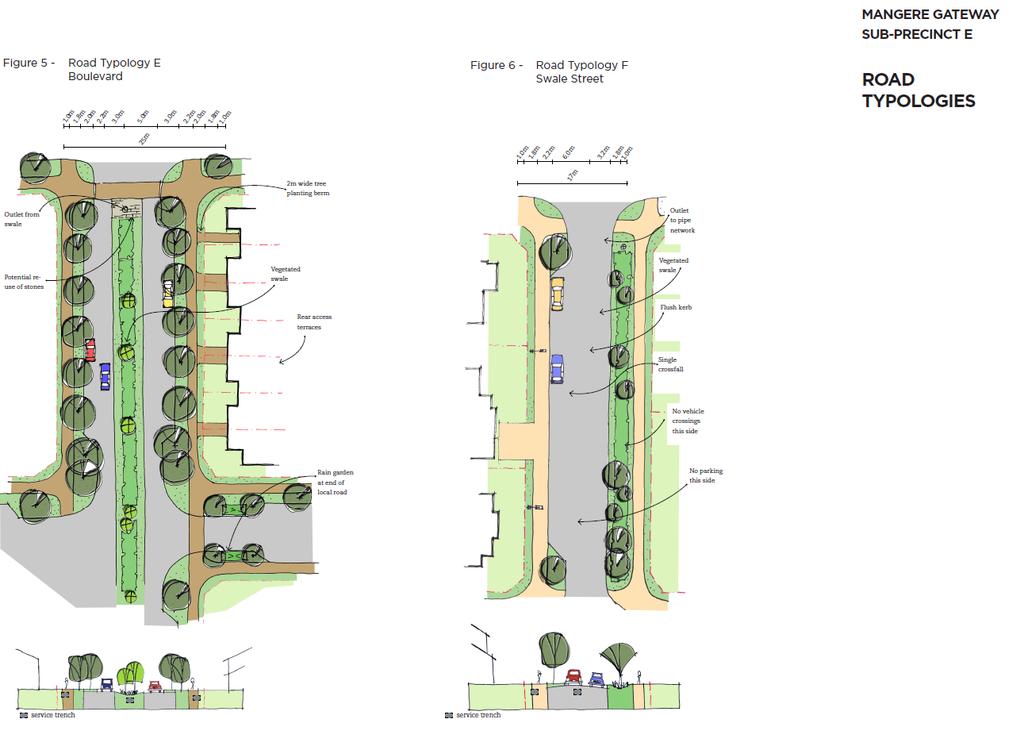
25 25 Table 4: Road construction standards in the Mangere Gateway sub-precinct E area Road Road width Carriageway (includes on-street parking) Footpath width Combined cycle/footpath Figure Road Typology A:Oruarangi Road 20m 8.4m 1.8m (one side) 3.6m (one side) Figure 1 Road Typology B: Ihumatao Quarry Road 20m 10.4m 1.8m 3m (one side) Figure 2 Road Typology C: Key Local Road 19m 10.4m 1.8m (both sides) N/A Figure 3 Local Road 17.5m 10.4m 1.8m (both sides) N/A Figure 4 Road Typology D: Maunga Edge Road 14.5m 8.2m 1.8m (one side) N/A Figure 5 Road Typology E: Boulevard 25m 15.4m (including central swale) 1.8m (both sides) N/A Figure 6 Road Typology F: Swale Street 17m 8.2m 1.8m (both sides) N/A Figure Heritage Route footpaths Purpose: To provide for visual distinction of the Mangere Gateway Heritage Route within the sub-precinct E area. 1. Footpaths provided within the road reserve of Ihumātao Quarry Road must be coloured with a 4kg/m 3 black oxide Gateway and threshold features Purpose:
26 26 To provide a sense of place in the Mangere Gateway sub-precinct E that references the unique cultural setting and identity of the area. To create unique and special places which function as markers along the Mangere Gateway Heritage Route To provide an entry feature at the intersection of Oruarangi Road and Ihumātao Quarry Road. To provide an entry feature to the Otuataua Stonefields Historic Reserve. 1. The location of the entry/gateway features must be in general accordance with the Mangere Gateway sub-precinct E precinct plan. The entry/gateway features may incorporate the following: a. Contrasting road surface treatments b. Unique/contrasting planting c. Signage d. Public art e. Street furniture f. Other design features agreed in consultation with Mana Whenua. The design of entry/gateway features should incorporate mataurangi and tikanga Maori, and be designed in consultation with Mana Whenua. 2. The location of the threshold area must be in general accordance with the Mangere Gateway sub-precinct E precinct plan. The threshold area may incorporate the following: a. Contrasting road surface treatments b. Contrasting specimen planting c. Public art d. Stone walls (using stones obtained from within the precinct where possible) as corner definitions e. Wider road berms f. Street furniture g. Other design features that are agreed in consultation with Mana Whenua.
27 27 The design of the threshold area should incorporate mataurangi and tikanga Maori and be designed in consultation with Mana Whenua Access/Interface Detail 1 (Swale Road) Purpose: To exclude vehicle crossings from directly accessing one side of the Swale Road to allow for the unimpeded capture and conveyance of overland flows/stormwater. To provide a high level of streetscape amenity. 1. In the location shown on the Mangere Gateway sub-precinct E sub-precinct Plan (annotated as Access/Interface Detail 1) residential lots are to be excluded from having direct vehicle access to the Swale Road. 2. Up to three road intersections may cross the Swale Road at logical locations to provide for east-west vehicle and pedestrian connections through the subprecinct E area Access/Interface Detail 2 (Oruarangi Road) Purpose: To limit the number of vehicle crossings directly accessing Oruarangi Road To enhance the Mangere Gateway Heritage Route through restoration of sections of the stone walls. 1. In the location shown on the Mangere Gateway sub-precinct E sub-precinct Plan (annotated as Access/Interface Detail 2 ) residential lots must be provided vehicle access by way of slip lanes to reduce the number of individual vehicle crossings accessing Oruarangi Road, and to provide for restoration of sections of the stone walls Stone feature wall Purpose: To provide for restoration and retention of portions of the historic drystone walls located within the sub-precinct E area. 1. Restored stone feature walls must be provided along slip lanes running parallel to Oruarangi Road, as illustrated in Figure 1. The restored stoned walls must be provided in the location shown on the Mangere Gateway sub-precinct E sub-precinct plan annotated as Access/Interface Detail Landscaping
28 28 Purpose: To ensure that plantings on sites adjoining Ihumātao Quarry Road and the Public Open Space area located to the south-west of the sub-precinct E area are provided in perpetuity. To provide for Mana Whenua input into the design of landscaping to be incorporated into public roads and areas of open space in the sub-precinct. 1. Consent notices must be registered on the Certificates of Title for sites with frontage to Ihumātao Quarry Road requiring compliance with rule of the Mangere Gateway sub-precinct E on an ongoing basis. 2. Consent notices must be registered on the Certificates of Title for sites with a common boundary with the Public Open Space located to the south-west of the sub-precinct E, requiring compliance with rule of the Mangere Gateway sub-precinct E on an ongoing basis. 3. The detailed design of landscape features and elements in roads and areas of open space located in the sub-precinct E area shall be undertaken in parallel with the engineering plan approval process, and must have regard to Mana Whenua values. Compliance with this rule will be required by appropriate conditions of consent imposed on any subdivision application that includes new roads, upgrades to existing roads, and/or creation of areas of open space Noise Purpose: To ensure that potential reverse sensitivity effects from the Auckland International Airport on residential amenity are appropriately addressed and provided for in the sub-precinct. 1. No-complaints covenants addressing potential reverse sensitivity issues arising from the proximity of the Mangere Gateway sub-precinct E to the Auckland International Airport must be registered on the Certificates of Title for each site created in the Mangere Gateway sub-precinct E area Lighting Purpose: To ensure that street lighting and outdoor lighting does not affect aircraft operations. To ensure Maori cultural values are protected through a reduction in potential light spill effects on the adjacent Otuataua Stonefields Historic Reserve and the Papakainga housing.
29 29 1. Street lighting must comply with Part 3.H, Auckland-wide rules 6.1 Lighting. 7. Assessment 7.2 Restricted discretionary activities Matters of discretion 1. Subdivision in accordance with the Mangere Gateway sub-precinct E sub-precinct plan The Council will restrict its discretion to the matters below for the activities listed as restricted discretionary in the sub-precinct E Subdivision Activity Table: 1. Consistency with the Mangere Gateway sub-precinct E sub-precinct plan 2. The design and location of the subdivision 3. The matters for discretion outlined in Part 3 H.5.4, Table Development control infringements The Council will restrict its discretion to those matters listed in Part 3 G.2.3 and Part 3.I. 1.11, for development in the Mangere Gateway sub-precinct E unless otherwise specified below. a) Heritage Route footpaths i. A high and consistent standard of amenity along Ihumātao Quarry Road. ii. Design elements that integrate the natural and built environment along Ihumātao Quarry Road. iii. Consistency with the Mangere Gateway sub-precinct E sub-precinct plan b) Gateway and threshold features i. The nature, form, scale, location, design, materials, finish and extent of the proposal ii. The effect of the proposal on place making and reference to the cultural and historic identity of the area iii. Integration of matauranga and tikanga into the development iv. Design, external appearance and landscaping
30 30 v. Consistency with the Mangere Gateway sub-precinct E sub-precinct Plan vi. Consultation with Mana Whenua vii. The purpose of the development control viii.effects on traffic and vehicle manoeuvring. c) Access/Interface Detail 1 (Swale Road) i. Effect on the function of the swale ii. Impact on the conveyance of overland flows/stormwater iii. Adverse effects on the function of the swale, and the amenity values of the streetscape iv. The purpose of the development control. d) Access/Interface Detail 2 (Oruarangi Road) i. Alternative methods to achieve the purpose of the development control. e) Stone feature walls i. The nature, form, scale, location, design, materials, finish and extent of the proposal ii. The effect of the proposal on the heritage and Mana Whenua values of the place including effects on its setting iii. The purpose and necessity for the works and any alternatives considered iv Design, external appearance and landscaping v. Consistency with the Mangere Gateway Sub-Precinct E Sub-Precinct Plan vi. communal devices. f) Lighting i. Traffic safety (including aircraft safety) ii. Airport operations iii. Visual amenity iv. Hours of operation.
31 Assessment criteria 1. Subdivision in accordance with the Mangere Gateway sub-precinct E sub-precinct plan The Council will consider the relevant assessment criteria below for the activities listed as restricted discretionary in the Subdivision Activity Table for the Mangere Gateway sub-precinct E. 1. Subdivision should implement and generally be consistent with: a. The structural elements of Mangere Gateway sub-precinct E subprecinct plan, including: Roads; Neighbourhood park provision; Green Infrastructure corridor provision; Public Open Space Conservation provision; Development setbacks from the Otuataua Stonefields Historic Reserve and the adjacent Papakainga area; Fencing detail typologies; Stone wall feature detail; and Entry/gateway feature and threshold feature provision. b. the roading typologies for the Mangere Gateway sub-precinct E; c. the objectives and policies for the sub-precinct E area; d. the relevant rules of the Mixed Housing Suburban zone; and e. the assessment criteria in Part 3. H.5.4 f. the extent to which the stormwater device(s) can be accommodated within the Green Infrastructure Corridor zone to allow efficient operation and maintenance, and appropriate amenity. 2. Development control infringements The Council will consider the relevant assessment criteria listed in Part 3.G.2.3 and Part 3.I.1.11, for development in the Mangere Gateway subprecinct E unless otherwise specified below. 2.1 Heritage Route footpath
32 32 1. Ensure that the character and identity of the Mangere Gateway heritage route (along Ihumātao Quarry Road), including the unique cultural and historic setting of the area, is appropriately provided for. 2. The effect on the nature, character, Mana Whenua values and heritage values of the place as a whole 3. The proposal should maintain or enhance heritage values of the Mangere Gateway sub-precinct E area, including: a. Recovering or revealing heritage values of Orurangi; and b. Complementing the form and fabric that contributes to, or is associated with, the heritage values of Orurangi. 2.2 Gateway and threshold features 1. Provide for the character and identity of the Mangere Gateway Heritage Route, including the unique cultural and historic setting for the development. 2. Development should incorporate mataurangi and tikanga (in consultation with Mana Whenua) into the design of gateway features. 3. The proposal should maintain or enhance heritage values of the Mangere Gateway sub-precinct E area, including: a. Recovering or revealing heritage values of Oruarangi; and b. Complementing the form and fabric that contributes to, or is associated with, the heritage values of Oruarangi. 4. The proposal should not result in adverse effects on traffic movements and manoeuvring on the road. 2.3 Access/Interface Detail 1 (Swale Road) 1. The proposal should not result in adverse effects on the function of the swale 2. The proposed mitigation should provide for streetscape amenity 3. Measures proposed to mitigate adverse effects on the function of the swale 4. How the proposal will achieve the purpose of the development control. 2.4 Access/Interface Detail 2 (Oruarangi Road) 1. Alternative methods to achieve the purpose of the development control. 2.5 Stone feature walls
33 33 1. Ensure that the proposal is of an appropriate form, scale, location and finish reflecting the historic nature of the original drystone walls. 2. The effect on the character, Mana Whenua values and heritage values of Oruarangi Road and the sub-precinct E area. 3. The proposal should maintain or enhance heritage values of the Mangere Gateway sub-precinct E area, including: a. Recovering or revealing heritage values of Oruarangi; and b. Complementing the form and fabric which contributes to, or is associated with, the heritage values of the place. 4. Measures proposed to mitigate adverse effects on the streetscape of Oruarangi Road, including external appearance and landscaping. 2.6 Lighting 1. The number, placement, design, height, colour, positioning and screening of light fittings and light poles, and the potential for adverse effects on traffic safety (including air traffic), operation of the Auckland International Airport, and visual amenity. 2. The maximum level of light to be permitted. 3. The effect of light spill on the Pukeiti and Otuataua volcanic cones. 4. Consideration will be given to the views of Iwi obtained through consultation. Zoning Map
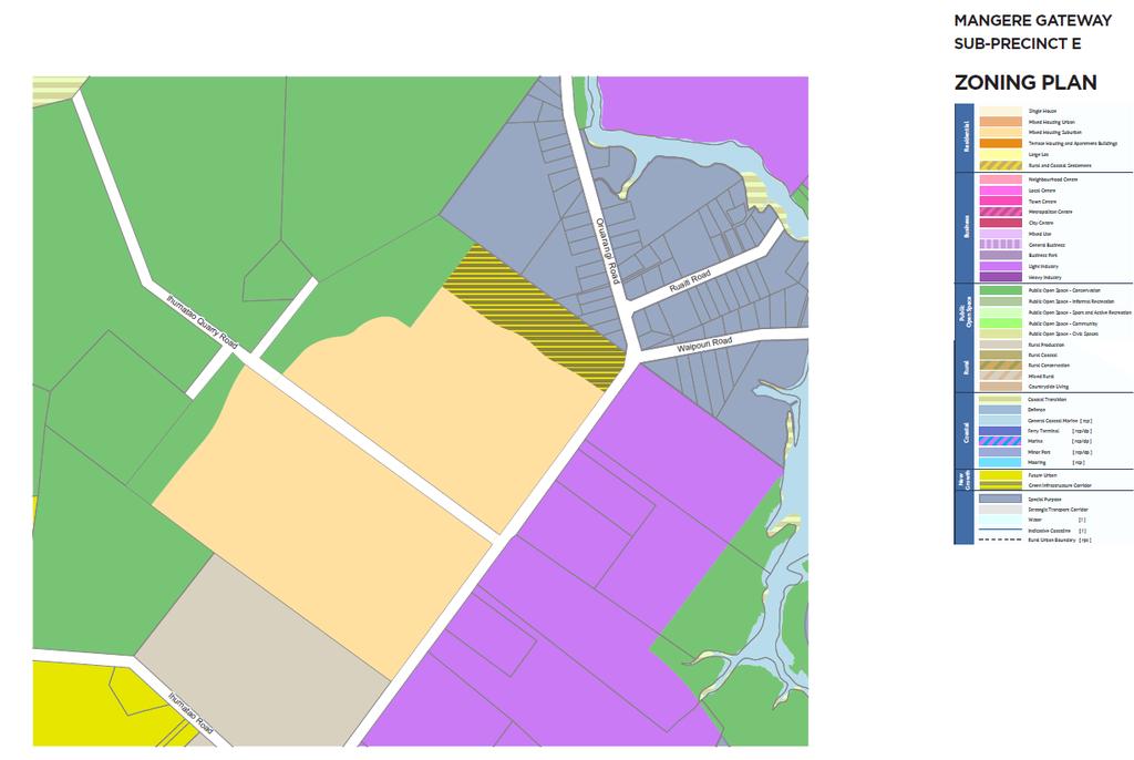
34 34

35 35 SUB-PRECINCT PLANS Precinct Plan 1

36 36 Precinct Plan 2
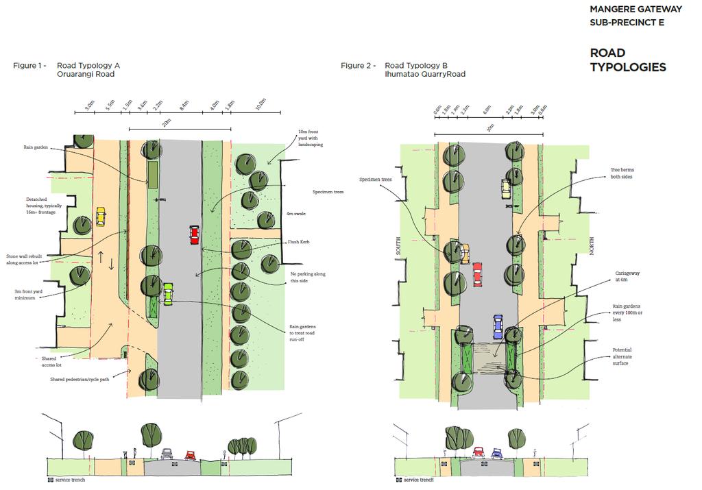
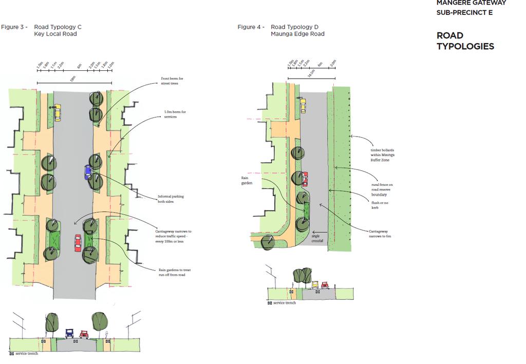
37 37 ROAD TYPOLOGIES
38 38

39 39 FENCING TYPOLOGIES

40 40 Planting Guide The following planting guide indicates suitable species and planter bag sizes for street trees.
41 41
42 42
43 43
This sub-precinct covers the Mixed Housing Suburban areas located adjacent to the Otuataua Stonefields Historic Reserve.
 6.15 Māngere Gateway Precinct description Subprecinct E This sub-precinct covers the Mixed Housing Suburban areas located adjacent to the Otuataua Stonefields Historic Reserve. Sub-precinct E is comprised
I422. Māngere Gateway Precinct
 I422. Māngere Gateway Precinct I422.1. Precinct description The Māngere Gateway Precinct is comprised of land generally north of the Auckland International Airport and west of George Bolt Memorial Drive
I615. Westgate Precinct
 I615. Westgate Precinct I615.1. Precinct Description The Westgate Precinct is located approximately 18km west of the Auckland city centre. There are seven Sub-precincts in the Westgate Precinct: Sub-precinct
 BEFORE ± Mcgregor Road Jones Road 151 Parcel boundary Rural - Rural Production Zone Rural - Mixed Rural Zone Road [i] AFTER Mcgregor Road Jones Road 151 Parcel boundary Rural - Rural Production Zone Rural
I539. Smales 2 Precinct
 I539. Smales 2 Precinct I539.1. Precinct Description The Smales 2 Precinct applies to a 4.8 hectare block of land located on the southern side of Northcote Road and fronting Lake Pupuke, Takapuna. The
I404 Beachlands 2 Precinct
 I404. Beachlands 2 I404.1. Precinct Description The Beachlands 2 precinct covers approximately 6 hectares of land at the corner of Beachlands and Whitford Maraetai Roads. Its purpose is to provide for
H7 Open Space zones. (a) provide for the needs of the wider community as well as the needs of the community in which they are located;
 provide for the needs of the wider community as well as the needs of the community in which they are located;") H7. Open Space zones H7.1. Background The majority of land zoned as open space is vested in the Council or is owned by the Crown. However some areas zoned open space are privately owned. While the open
H7. Open Space zones H7.1. Background The majority of land zoned as open space is vested in the Council or is owned by the Crown. However some areas zoned open space are privately owned. While the open
I609. Penihana North Precinct
 I609. Penihana North Precinct I609.1. Precinct description The Penihana North Precinct is located south of the Swanson Railway Station, adjacent to the Rural Urban Boundary (RUB) and Waitakere Ranges Heritage
Appendix 1 Structure plan guidelines
 Appendix 1 Structure plan guidelines This appendix forms part of the regional policy statement [rps]. 1.1. Introduction Structure plans are an important method for establishing the pattern of land use
I403 Beachlands 1 Precinct
 I403. Beachlands 1 I403.1. Precinct Description Beachlands is a rural and coastal village located on the eastern side of Auckland, adjoining the Tamaki Strait coastline. The original Beachlands village
I602. Birdwood Precinct
 I602. Birdwood Precinct I602.1. Precinct description The Birdwood Precinct applies to an area west of Don Buck Road and south of Red Hills Road in west Auckland. It incorporates subdivision and development
H1. Residential Large Lot Zone
 H1. Residential Large Lot Zone H1.1. Zone description The Residential Large Lot Zone provides for large lot residential development on the periphery of urban areas. Large lot development is managed to
I333 Three Kings Precinct
 I333. Three Kings I333.1. Precinct description The Three Kings Precinct provides for the development of a vibrant, sustainable urban village on the former quarries and the adjacent land at Three Kings.
H14. Business General Business Zone
 H14. Business General Business Zone H14.1. Zone description The Business General Business Zone provides for business activities from light industrial to limited office, large format retail and trade suppliers.
I209 Quay Park Precinct
 I209. Quay Park I209.1. Precinct description The Quay Park Precinct is located on reclaimed land at the eastern end of the city centre and along the City Centre waterfront. It is dissected to the east
Section 12C Subdivision in the Rural Residential Zone
 Section 12C 12C Subdivision in the Rural Residential Zone The Rural Residential Zone provides part of the range of residential opportunities within the City. Land zoned rural residential is considered
I611. Swanson North Precinct
 I611. Swanson North Precinct I611.1. Precinct Description Swanson North is located in the north eastern foothills of the Waitakere Ranges. It is outside the Waitakere Ranges Heritage Area Act and the Waitakere
The Proposed Auckland Unitary Plan (notified 30 September 2013)
") 3 Business zones Introduction There are 10 business zones in the Unitary Plan: City Centre Metropolitan Centre Town Centre Local Centre Neighbourhood Centre Mixed Use General Business Business Park Light
3 Business zones Introduction There are 10 business zones in the Unitary Plan: City Centre Metropolitan Centre Town Centre Local Centre Neighbourhood Centre Mixed Use General Business Business Park Light
I207. Learning Precinct
 I207. Learning Precinct I207.1. Precinct description The Learning Precinct is centred on the Symonds Street ridge where the University of Auckland and Auckland University of Technology have the majority
Section Three, Part 16 Takanini Structure Plan Area
 PART 16 TAKANINI STRUCTURE PLAN AREA 16.1 Residential 8 zone 16.1.1 Objectives and Policies 16.1.2 Rules: General 16.1.3 Rules: Activity Status Subdivision (Except within the Addison Neighbourhood Centre)
H9. Business Metropolitan Centre Zone
 H9. Business Metropolitan Centre Zone H9.1. Zone description The Business Metropolitan Centre Zone applies to centres located in different subregional catchments of Auckland. These centres are second only
I326. Ōrākei 1 Precinct
 I326. Ōrākei 1 recinct I326.1. recinct Description The Ōrākei 1 recinct includes the land identified as hapu reservation (land held for the purposes of a marae, church, urupa and related hapu amenities)
I331. St John s Theological College Precinct
 I331. St John s Theological College Precinct I331.1. Precinct Description The precinct contains the existing St John s Theological College which is a residential college for the Anglican Church in New
I412. Flat Bush Precinct
 I412. Flat Bush Precinct I412.1. Precinct description The Flat Bush precinct covers approximately 1730ha of land adjacent to the Rural Urban Boundary. The Flat Bush Precinct incorporates the provisions
Tāhuhu whakaruruhau ā-taone The sheltering ridge pole
 B2. Tāhuhu whakaruruhau ā-taone - Urban growth and form B2.1. Issues Tāhuhu whakaruruhau ā-taone The sheltering ridge pole Auckland s growing population increases demand for housing, employment, business,
4 Residential and Urban Living Zones
 4 Residential and Urban Living Zones Refer to Chapters 11 to 20 for additional rules that may apply to these zones. 4.1 OBJECTIVES AND POLICIES Objective Res1 Policy 1 Policy 2 Policy 3 Policy 4 Policy
H13. Business Mixed Use Zone
 H13. Business Mixed Use Zone H13.1. Zone description The Business Mixed Use Zone is typically located around centres and along corridors served by public transport. It acts as a transition area, in terms
Section 3b: Objectives and Policies Rural Environment Updated 19 November 2010
 Page 1 of Section 3b 3b RURAL ENVIRONMENT 3b.1 Introduction The Rural Environment comprises all the land outside of the Residential, Town Centre and Industrial Environments. Most land within the District
Section Three, Appendix 16C Medium Density Housing, Design Assessment Criteria (Residential 8A zone)
") APPENDIX 16C MEDIUM DENSITY HOUSING, DESIGN ASSESSMENT CRITERIA (RESIDENTIAL 8A ZONE) PURPOSE OF APPENDIX 16C (RESIDENTIAL 8A ZONE) In the Residential 8A Zone the following are defined as restricted discretionary
APPENDIX 16C MEDIUM DENSITY HOUSING, DESIGN ASSESSMENT CRITERIA (RESIDENTIAL 8A ZONE) PURPOSE OF APPENDIX 16C (RESIDENTIAL 8A ZONE) In the Residential 8A Zone the following are defined as restricted discretionary
1. Assessment of Environmental Effects
 1. Assessment of Environmental Effects Table of Contents 1. Introduction and Overview 1 2. Statutory Assessment 3 3. Site Description 5 4. Proposal Description 7 5. Assessment of Effects on the Environment
Subdivision Design Criteria. Penihana North GUIDELINES TO THE RULES
 Created September 2013 Penihana North Subdivision Design Criteria GUIDELINES TO THE RULES This part of the Plan sets out the design criteria for subdivision in Penihana North. The criteria will be considered
H10. Business Town Centre Zone
 H10. Business Town Centre Zone H10.1. Zone description The Business Town Centre Zone applies to suburban centres throughout Auckland, the satellite centres of Warkworth and Pukekohe, and the rural towns
11.3 SPECIAL CHARACTER ZONE HAWKE S BAY REGIONAL SPORTS PARK
 11.3 SPECIAL CHARACTER ZONE HAWKE S BAY REGIONAL SPORTS PARK 11.3.1 INTRODUCTION The availability of sports and recreation activities and facilities is important for the maintenance and enhancement of
open space environment
 This section updated August 09 GUIDELINE TO THE RULES The Open Space Environment Rules apply to activities on sites within the Open Space Environment as shown on the Human Environments Maps. Most of the
Subdivision and Development
 Subdivision and Development 8.0 Introduction - Subdivision and Development The principle purpose of subdivision is to provide a framework for land ownership so that development and activities can take
AOTEA SUPERMARKET ZONE. Zone Introduction
 C18 AOTEA SUPERMARKET ZONE Zone Introduction C18.1 Objective This zone identifies a specific area in Aotea for a stand alone supermarket. The zone is site specific and has a range of objectives, policies
39 WALLACEVILLE STRUCTURE PLAN
 39 WALLACEVILLE STRUCTURE PLAN PRECINCT DESCRIPTIONS, INTENTIONS AND OUTCOMES Wallaceville Living Precinct Area A At approximately 13.4ha, this precinct is the largest precinct and the precinct provides
D18. Special Character Areas Overlay Residential and Business
 D18 Overlay Residential and Business D18. Overlay Residential and Business D18.1. Background The Overlay Residential and Business seeks to retain and manage the special character values of specific residential
SPECIAL 35 (HIBISCUS COAST GATEWAY) ZONE
 ZONE") `` 12.8.35 SPECIAL 35 (HIBISCUS COAST GATEWAY) ZONE 12.8.35.1 Issues The following provisions relate to the Hibiscus Coast Gateway Zone. This zone is located at Silverdale in the area bounded by State
`` 12.8.35 SPECIAL 35 (HIBISCUS COAST GATEWAY) ZONE 12.8.35.1 Issues The following provisions relate to the Hibiscus Coast Gateway Zone. This zone is located at Silverdale in the area bounded by State
I311. Ellerslie 1 Precinct
 I311. Ellerslie 1 Precinct I311.1. Precinct Description The Ellerslie 1 precinct applies to 6.0974 ha of land within the Auckland Racing Club s Ellerslie Racecourse. The land, most of which is not used
The Proposed Auckland Unitary Plan (notified 30 September 2013)
") 8 Special Purpose zones 8.1 Airport zone The Airport zone applies to the Kaipara Flats Airfield, North Shore Airfield, Auckland International Airport and Ardmore Airport. Auckland International Airport
8 Special Purpose zones 8.1 Airport zone The Airport zone applies to the Kaipara Flats Airfield, North Shore Airfield, Auckland International Airport and Ardmore Airport. Auckland International Airport
12 Subdivision, Services and Infrastructure
 12 Subdivision, Services and Infrastructure Section 12A 12A Purpose of Subdivision Provisions... 1 12A.1 General Subdivision Objectives and Policies... 2 12A.2 Activity Status Rules... 4 12A.3 General
Plan Modification to Chapter B2 of the Auckland Unitary Plan(AUP) Operative in part (15 November 2016)
 Operative in part (15 November 2016)") UNITARY PLAN UPDATE REQUEST MEMORANDUM TO FROM Phill Reid Linley Wilkinson DATE 25 September 2018 SUBJECT Plan Modification to Chapter B2 of the Auckland Unitary Plan(AUP) Operative in part (15 November
UNITARY PLAN UPDATE REQUEST MEMORANDUM TO FROM Phill Reid Linley Wilkinson DATE 25 September 2018 SUBJECT Plan Modification to Chapter B2 of the Auckland Unitary Plan(AUP) Operative in part (15 November
4 RESIDENTIAL ZONE. 4.1 Background
 4 RESIDENTIAL ZONE 4.1 Background The residential areas within the City are characterised by mainly lowrise dwellings sited on individual allotments. Past architectural styles, settlement patterns and
Keystone Business Park Precinct Structure Plan North East Industrial Precinct. Part 2 Design Principles
 Keystone Business Park Precinct Structure Plan North East Industrial Precinct Part 2 Design Principles Context Issues Services Landform Issues Geotech and contamination Ecology Traffic and access Issues
Proposed Southland District Plan 2012 Appeal Version October 2016
 S e c t i o n 3. 5 - F i o r d l a n d / R a k i u r a Z o n e The Fiordland/Rakiura Zone encompasses the Fiordland and Rakiura National Parks and part of Mt Aspiring National Park. It also includes areas
Nelson Residential Street Frontage Guideline
 DRAFT 22-06-2012 Nelson Residential Street Frontage Guideline June 2012 1317273 Contents and purpose Residential s are important Residential s are much more than corridors which move traffic. Streets allow
I604. Hobsonville Marina Precinct
 I604. Hobsonville Marina Precinct I604.1. Precinct description Hobsonville Marina Precinct is located at Clearwater Cove, Hobsonville in Auckland s upper Waitemata Harbour. The precinct includes the coastal
I432. Puhinui Precinct
 I432. Puhinui Precinct [ENV-2016-AKL-000199: Self Family Trust] Addition sought I432.1. Precinct Description The primary purpose of the Puhinui Precinct is to enable a transition from rural to urban development,
Mark-up of the effect of the proposed Bronte Village Growth Area OPA No.18 on the text of section 24, Bronte Village, of the Livable Oakville Plan
 Mark-up of the effect of the proposed Bronte Village Growth Area OPA No.18 on the text of section 24, Bronte Village, of the Livable Oakville Plan Notes: This document is provided for information purposes
Section 12B 12B Subdivision in Residential Zones
 Section 12B 12B Subdivision in Residential Zones The Residential Zones provide for a range of infill and greenfield living opportunities across the City for the community to accommodate current and future
15 Rural Residential Zone
 15 Rural Residential Zone Section 15A 15A Purpose of the Rural Residential Zone... 1 15A.1 Objectives and Policies of the Rural Residential Zone... 1 15A.2 Activity Status Rules... 5 15A.3 Permitted Activity
SCHEDULE 12 TO THE DESIGN AND DEVELOPMENT OVERLAY GLEN WAVERLEY ACTIVITY CENTRE STRUCTURE PLAN
 DD/MM/YY Proposed C120 SCHEDULE 12 TO THE DESIGN AND DEVELOPMENT OVERLAY Shown on the planning scheme map as DDO12. GLEN WAVERLEY ACTIVITY CENTRE STRUCTURE PLAN 1.0 Design objectives DD/MM/YY Proposed
22.15 OUTDOOR ADVERTISING SIGNAGE POLICY
 22.15 OUTDOOR ADVERTISING SIGNAGE POLICY This policy applies to all land where a planning permit is required to construct or display a sign under the provisions of the Kingston Planning Scheme. 22.15-1
I334. Wairaka Precinct
 I334. Wairaka Precinct I334.1. Precinct Description The Wairaka Precinct extends from the north western motorway at Point Chevalier in the north, through to Woodward Road in the south, and from Oakley
Rural (Urban Expansion) Environment
 Environment") RUEE.1 Rural (Urban Expansion) Environment Subsequent to the receipt of appeals, a 'marked up' version of the Proposed District Plan was prepared. The provisions of the Proposed Version of the Plan subject
RUEE.1 Rural (Urban Expansion) Environment Subsequent to the receipt of appeals, a 'marked up' version of the Proposed District Plan was prepared. The provisions of the Proposed Version of the Plan subject
SECTION 7A: WHAKARONGO RESIDENTIAL AREA
 SECTION 7A: WHAKARONGO RESIDENTIAL AREA CONTENTS 7A.1 Introduction 1 7A.2 Resource Management Issues 1 7A.3 Objectives and Policies 1 7A.4 Methods 4 7A.5 Residential Zone 4 7A.5.1 Rules: Controlled Activities
Memorial Business Park Site. Proposed Future Development. Design guidelines. August
 Memorial Business Park Site Proposed Future Development Design guidelines August 2014 www.designenvironment.co.nz 0064 3 358 3040 Contents 1.0 Background 1.1 Introduction 3 1.2 Objectives 4 2.0 Context
FORMER CANADIAN FORCES BASE (CFB) ROCKCLIFFE SECONDARY PLAN. Official Plan Amendment XX to the Official Plan for the City of Ottawa
 ROCKCLIFFE SECONDARY PLAN. Official Plan Amendment XX to the Official Plan for the City of Ottawa") FORMER CANADIAN FORCES BASE (CFB) ROCKCLIFFE SECONDARY PLAN Official Plan Amendment XX to the Official Plan for the City of Ottawa 1 INDEX THE STATEMENT OF COMPONENTS PART A THE PREAMBLE PAGE Purpose...
FORMER CANADIAN FORCES BASE (CFB) ROCKCLIFFE SECONDARY PLAN Official Plan Amendment XX to the Official Plan for the City of Ottawa 1 INDEX THE STATEMENT OF COMPONENTS PART A THE PREAMBLE PAGE Purpose...
Section 6A 6A Purpose of the Natural Features and Landscapes Provisions
 Section 6A 6A Purpose of the Natural Features and Landscapes Provisions This Chapter addresses the protection and management of natural features and landscapes within the City. The City has a number of
Part 4.25 Pasminco Area Plan
 1 INTRODUCTION The purpose of this Area Plan is to guide the redevelopment of the former Pasminco Cockle Creek Smelter site and the former Incitec Pivot Fertilizer site. The Pasminco and Incitec sites
D10. Outstanding Natural Features Overlay and Outstanding Natural Landscapes Overlay
 D10. Outstanding Natural Features Overlay and Outstanding Natural Landscapes Overlay D10.1. Background These provisions give effect to Policy 15(a) of the New Zealand Coastal Policy Statement 2010, and
Auckland City Operative District Plan (Isthmus 1999) Private Plan Change: Three Kings Precinct PA372
 Private Plan Change: Three Kings Precinct PA372") Auckland City Operative District Plan (Isthmus 1999) Private Plan Change: Three Kings Precinct Under Part 2 of Schedule 1 of the Resource Management Act 1991 PA372 1 2 3 Part C: Insert the following in
Auckland City Operative District Plan (Isthmus 1999) Private Plan Change: Three Kings Precinct Under Part 2 of Schedule 1 of the Resource Management Act 1991 PA372 1 2 3 Part C: Insert the following in
18 Industrial Zones. Section 18A. Appendices
 18 Industrial Zones Section 18A 18A Purpose of the Industrial Zones... 1 18A.1 Purpose of the Industry Zone... 1 18A.2 Purpose of the Port Industry Zone... 1 18A.3 Purpose of the Tauriko Industry Zone...
2A District-wide Policies
 2A Introduction This Chapter contains policies which are relevant to subdivision, use and development activities occurring across all zones and areas of the District. The policies in this Chapter implement
D10. Outstanding Natural Features Overlay and Outstanding Natural Landscapes Overlay
 D10. Outstanding Natural Features Overlay and Outstanding Natural Landscapes Overlay D10.1. Background These provisions give effect to Policy 15(a) of the New Zealand Coastal Policy Statement 2010, and
COMMUNITY DESIGN. GOAL: Create livable and attractive communities. Intent
 COMMUNITY DESIGN Intent An attractive, well-designed County will attract quality development, instill civic pride, improve the visual character of the community, and create a strong, positive image for
BEFORE THE AUCKLAND UNITARY PLAN INDEPENDENT HEARINGS PANEL
 1 BEFORE THE AUCKLAND UNITARY PLAN INDEPENDENT HEARINGS PANEL IN THE MATTER of the Resource Management Act 1991 and the Local Government (Auckland Transitional Provisions) Act 2010 AND IN THE MATTER of
NORTH EAST INDUSTRIAL ZONE
 SECTION 12A: NORTH EAST INDUSTRIAL ZONE CONTENTS 12A.1 Introduction 1 12A.2 Resource Management Issues 2 12A.3 Objectives and Policies 3 12A.4 Rules: Permitted Activities 8 R12A.4.1 Permitted Activities
RESIDENTIAL. QLDC PROPOSED DISTRICT PLAN [PART THREE] DECISIONS VERSION 8 medium density residential
![RESIDENTIAL. QLDC PROPOSED DISTRICT PLAN [PART THREE] DECISIONS VERSION 8 medium density residential](/thumbs/84/89275880.jpg "RESIDENTIAL. QLDC PROPOSED DISTRICT PLAN [PART THREE] DECISIONS VERSION 8 medium density residential") 8 MEDIUM DENSITY RESIDENTIAL QLDC PROPOSED DISTRICT PLAN [PART THREE] DECISIONS VERSION 8 medium density residential QLDC PROPOSED DISTRICT PLAN [PART THREE] DECISIONS VERSION 8 medium density residential
8 MEDIUM DENSITY RESIDENTIAL QLDC PROPOSED DISTRICT PLAN [PART THREE] DECISIONS VERSION 8 medium density residential QLDC PROPOSED DISTRICT PLAN [PART THREE] DECISIONS VERSION 8 medium density residential
Rural (Urban Expansion) Environment
 Environment") RUEE.1 Rural (Urban Expansion) Environment Index RUEE.1 RUEE.1.1 RUEE.1.2 RUEE.1.3 RUEE.1.4 RUEE.2 RUEE.2.1 RUEE.2.2 RUEE.2.3 RUEE.2.4 RUEE.3 Rural (Urban Expansion) Environment Description and Expectations
RUEE.1 Rural (Urban Expansion) Environment Index RUEE.1 RUEE.1.1 RUEE.1.2 RUEE.1.3 RUEE.1.4 RUEE.2 RUEE.2.1 RUEE.2.2 RUEE.2.3 RUEE.2.4 RUEE.3 Rural (Urban Expansion) Environment Description and Expectations
and services The protection and conservation of environmentally significant and sensitive natural heritage features and functions.
 6. Land Use 6.0 Preamble A healthy and livable city is one in which people can enjoy a vibrant economy and a sustainable healthy environment in safe, caring and diverse neighbourhoods. In order to ensure
I511. Hatfields Precinct
 I511. Hatfields Precinct I511.1. Precinct Description The Hatfields Precinct is a contiguous 183.8 hectare block of rural land held in 8 freehold titles, located immediately to the north of Hatfields Beach.
Ensure that development within the Arrowtown Urban Growth Boundary provides:
 URBAN DEVELOPMENT 4 4.2.5.2 Ensure that development within the Arrowtown Urban Growth Boundary provides: an urban form that is sympathetic to the character of Arrowtown, including its scale, density, layout
THREE PARKS ZONE Three Parks Special Zone The process of applying for resource consents in the zone.
 .25 Three Parks Special Zone The purpose of this zone is to provide for growth and to give effect to the Wanaka 2020 Community (2002) and the more recent Wanaka Structure (2007) and Wanaka Transport Strategy
B4. Te tiaki taonga tuku iho - Natural heritage
 B4. Te tiaki taonga tuku iho - Natural heritage Tuia I runga, tuia i raro, tuia ki te waonui a Tiriwa Bind the life forces of heaven and earth to the great realm of Tiriwa B4.1. Issues Auckland s distinctive
Development Control Plan
 Development Control Plan Rhodes Corporate Park (Also known as the Digital Site) Development Control Plan Date of Adoption: 4 September 2007 Effective Date: 7 March 2008 Index 1 INTRODUCTION... 3 1.1 LAND
I309. Cornwall Park Precinct
 I309. Cornwall Park Precinct I309.1. Precinct Description Cornwall Park is a privately owned and managed landscaped park designed for public recreation and enjoyment and is a highly used and valued open
PART 6 - HUMAN ENVIRONMENT
 CONTENTS...PAGE 6.1 INTRODUCTION...3 6.2 ISSUES AND STRATEGY...3 ISTHMUS SECTION - OPERATIVE 1999 Page 1 Page 2 ISTHMUS SECTION - OPERATIVE 1999 PART 6 - HUMAN ENVIRONMENT 6.1 INTRODUCTION The Plan seeks
I505. Chelsea Precinct
 I505. Chelsea Precinct I505.1. Precinct Description This precinct covers land and water areas owned and/or formerly used by the Chelsea Sugar Refinery at Birkenhead. Chelsea Estate Heritage Park is owned
This table identifies new provisions sought to be added:
 Chapter 16 Business Mixed Use This table identifies new provisions sought to be added: Appellant Court Number FII Holdings Limited ENV-2018-CHC-084 FII Holdings Limited ENV-2018-CHC-084 Universal Developments
Section Three, Appendix 17C Multiple Unit Housing Design Assessment Criteria
 APPENDIX 17C MULTIPLE UNIT HOUSING DESIGN ASSESSMENT CRITERIA Purpose of Appendix 17C In the Residential 9 Zone the construction and use of multiple household units located within the Multiple Household
9.1 ISSUES OBJECTIVES RULES - Class B - Heritage Items RULES - Class C - Heritage Items RULES - Old Town Overlay Area 18
 9 HISTORIC HERITAGE 9.1 ISSUES 7 9.2 OBJECTIVES 7 9.3 POLICIES 8 9.4 RULES - Class A - Heritage Items 13 9.5 RULES - Class B - Heritage Items 15 9.6 RULES - Class C - Heritage Items 17 9.7 RULES - Old
SCHEDULE 10 TO THE URBAN GROWTH ZONE. Shown on the planning scheme map as UGZ10. Truganina Precinct Structure Plan. 1.0 The Plan
 SCHEDULE 10 TO THE URBAN GROWTH ZONE Shown on the planning scheme map as UGZ10 Truganina Precinct Structure Plan 1.0 The Plan Map 1 shows the future urban structure proposed in the Truganina Precinct Structure
REMARKABLES PARK ZONE
 .10 Remarkables Park Zone.10.1 Resources, Activities and Values The Remarkables Park Area comprises approximately 150 hectares of perimeter urban land in the vicinity of Frankton and occupies a strategic
QUEENSTOWN LAKES DISTRICT COUNCIL SUBDIVISION DESIGN GUIDELINES
 Attachment C: Draft QLDC Subdivision Design Guidelines QUEENSTOWN LAKES DISTRICT COUNCIL DESIGN GUIDELINES A DESIGN GUIDE FOR AND DEVELOPMENT IN THE URBAN ZONES QUEENSTOWN OFFICE 10 Gorge Road Queenstown
Section 18A Purpose of the Industrial Zones
 Section 18A 18A Purpose of the Industrial Zones The purpose of the Industrial Zones is to provide consolidated areas that are strategically located near higher order roads, rail lines and shipping routes
Landscaping Standards
 CHAPTER 29 ARTICLE 403 29.403 Landscaping Standards Purpose: The purpose of this section is to protect and promote the public health, safety and general welfare by requiring landscaping in relation to
SECTION ONE North East Industrial Zone Design Guide Palmerston North City Council June 2004
 SECTION ONE North East Industrial Zone Design Guide Palmerston North City Council June 2004 young heart easy living 1 Preface Industrial areas are a very important component of the economic well-being
City of Yelm. Tahoma Terra Final Master Plan Development Guidelines. Table of Contents
 City of Yelm Tahoma Terra Final Master Plan Development Guidelines Table of Contents Table of Contents... 1 Purpose... 2 Low Density Residential (R4-6)... 3 Moderate Density Residential (R6-10)... 5 Neighborhood
URBAN DESIGN BRIEF URBAN DESIGN BRIEF 721 FRANKLIN BLVD, CAMBRIDGE August 2018
 URBAN DESIGN BRIEF URBAN DESIGN BRIEF 721 FRANKLIN BLVD, CAMBRIDGE August 2018 DESIGN BRIEF CONTENTS PART A 1.0 INTRODUCTION 2.0 DESCRIPTION & ANALYSIS OF SITE CONTEXT 3.0 DESIGN CONSTRAINTS AND OPPORTUNITIES
URBAN DESIGN BRIEF REPORT
 URBAN DESIGN BRIEF REPORT PREPARED FOR 2568401 ONTARIO INC NEW GASBAR, CONVENIENCE STORE & CARWASH DEVELOPMENT @ 1509 FANSHAWE PARK ROAD WEST LONDON, ONTARIO GAMA ENGINEERING INC. PROJECT NUMBER 1669 PREPARED
SECTION 2.4 URBAN DEVELOPMENT AND STRATEGIC URBAN DIRECTIONS
 SECTION 2.4 URBAN DEVELOPMENT AND STRATEGIC URBAN DIRECTIONS 2.4.1 INTRODUCTION In 1993/94 the Hastings District Council completed the Hastings Urban Development Strategy. The purpose of this study was:
ARTICLE 6: Special and Planned Development Districts
 ARTICLE 6: Special and Planned Development Districts 6-10 Traditional Neighborhood Development (TND) District 6-10.10 Purpose and Intent The Traditional Neighborhood Development (TND) District provides
APPENDIX 1 DISTRICT PLAN CHANGE REQUEST
 APPENDIX 1 DISTRICT PLAN CHANGE REQUEST Summerset Villages (Lower Hutt) Ltd District Plan Change Request Prepared by Urban Perspectives Ltd 17 September 2014 65 39 66 PROPOSED DISTRICT PLAN CHANGE PROVISIONS
Northern Territory Compact Urban Growth Policy
 Northern Territory Compact Urban Growth Policy A Reference Policy Document to clause 2.7 (Reference to Policy) of the NT Planning Scheme May 2015 Table of Contents 1 Policy Setting... 3 1.1 Context for
Proposed for Vic West Neighbourhood Plan. Design Guidelines for Intensive Residential Development - Townhouse and Attached Dwelling
 Proposed for Vic West Neighbourhood Plan Design Guidelines for Intensive Residential Development - Townhouse and Attached Dwelling Design Guidelines for Intensive Residential Development - Townhouse and
Development Control Plan
 Development Control Plan Liberty Grove Development Control Plan Date of Adoption: 4 September 2007 Effective Date: 7 March 2008 Index 1 INTRODUCTION... 3 1.1 NAME OF PLAN... 3 1.2 AREA TO WHICH THIS PLAN
RURAL ZONE - POLICY. Rural Zone Policy. Issue: Rural Environment. Ruapehu District Plan Page 1 of 8
 Rural Zone Policy RU2 RURAL ZONE - POLICY RU2.1 Introduction The natural resources of the rural environment in the Ruapehu District provide the basis for the existing and potential character, intensity
2 Nelson City Council Dear Cottages
 2 Nelson City Council Dear Cottages Design Guide introduction DI1 Why a Design Guide? The Council, in the development of the Nelson Resource Management Plan, has identified particular residential areas