PLANNED UNIT DEVELOPMENT & SUBDIVISION STAFF REPORT Date: May 18, 2017
|
|
|
- Collin Newton
- 5 years ago
- Views:
Transcription
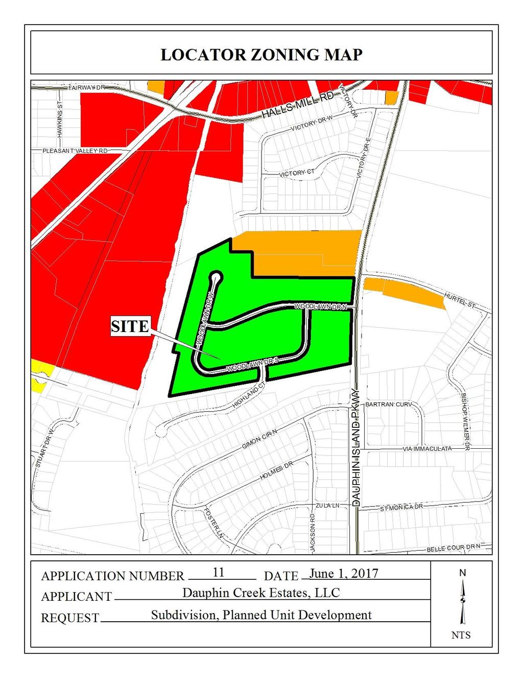
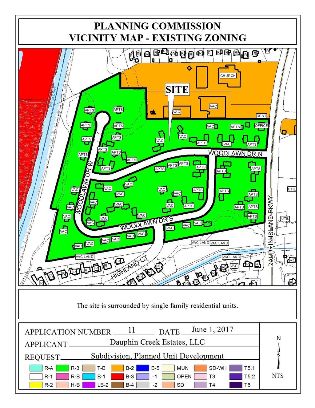
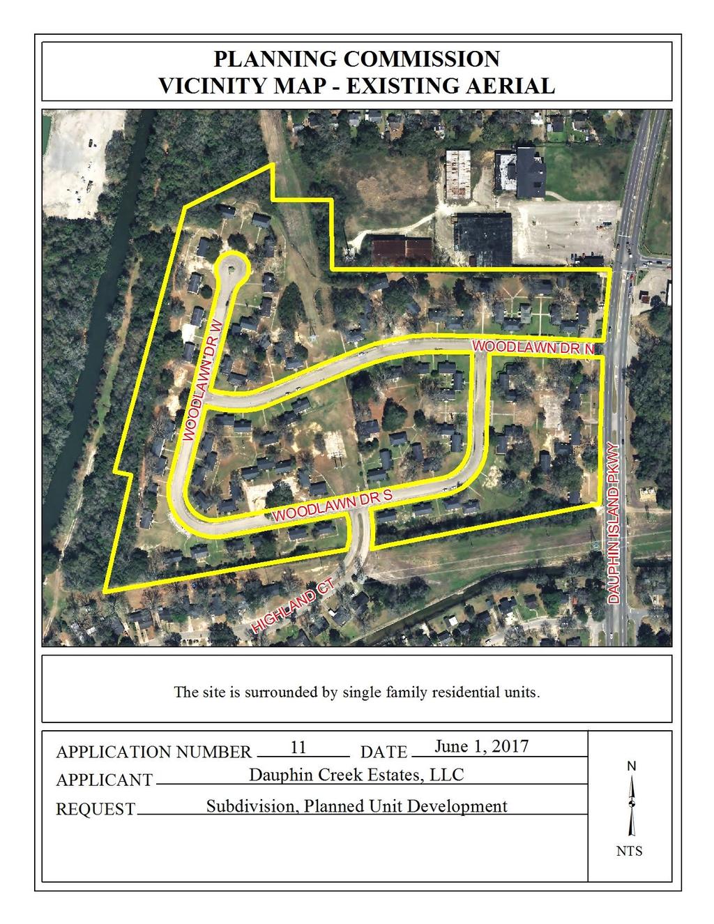
1 & PUD PLANNED UNIT DEVELOPMENT & SUBDIVISION STAFF REPORT Date: May 18, 2017 NAME SUBDIVISION NAME Dauphin Creek Estates Subdivision Dauphin Creek Estates Subdivision LOCATION CITY COUNCIL DISTRICT District 3 West side of Dauphin Island Parkway extending 120 ± East of Eslava Creek, situated around Woodland Drive and Highland Court PRESENT ZONING AREA OF PROPERTY CONTEMPLATED USE TIME SCHEDULE R-3, Multiple-Family Residential District 6 Lots / 29.0± Acres Subdivision approval to create six (6) legal lots of record from three metes-and-bounds parcels, and Planned Unit Development approval to allow multiple buildings on multiple building sites with shared access and parking. None provided ENGINEERING COMMENTS Subdivision: FINAL PLAT COMMENTS (should be addressed prior to submitting the FINAL PLAT for review and/or signature by the City Engineer): A. Provide all of the required information on the SUBDIVISION PLAT (i.e. signature blocks, signatures, certification statements, written legal description, required notes, legend, scale, bearings and distances) that is required by the current Alabama State Board of Licensure for Professional Engineers and Land Surveyors. B. Add major street names to the vicinity map. C. Review and revise the written legal description to include written bearings and distances for the three (3) separate parcels. D. Dedicate the corner radius (25 minimum or as approved by the City Engineer and Traffic Engineer) at the existing public rights-of-way to the City of Mobile, and list the amount of dedicated acreage. E. Show and label all flood zones. F. Show and label the MFFE (Minimum Finished Floor Elevation) on each lot that contains an AE, V, or X (shaded) flood zone designation. G. Show and label each and every Right-Of-Way and easement. H. Provide and label the monument set or found at each subdivision corner
2 I. Provide curve data for each curve. J. Use a different line type/weight to indicate previous parcel boundary lines that cross the existing rights-of-way. K. Provide the Surveyor s, Owner s (notarized), Planning Commission, and Traffic Engineering signatures. L. The proposed subdivision receives drainage from public streets and require a PUBLIC (Dedicated to the City of Mobile) drainage easement; the width and alignment of the easement shall be coordinated with, and approved by, the City Engineer. M. Add a note to the SUBDIVISION PLAT stating that a Land Disturbance permit will be required for any land disturbing activity in accordance with Mobile City Code, Chapter 17, Storm Water Management and Flood Control); the City of Mobile, Alabama Flood Plain Management Plan (1984); and, the Rules For Erosion and Sedimentation Control and Storm Water Runoff Control. N. Add a note to the SUBDIVISION PLAT stating that as shown on the 1984 aerial photo (FLIGHT 27 - #77) LOTS 1-6 will have to share the historical credit of existing (1984) impervious area towards stormwater detention requirement per Mobile City Code, Chapter 17, Storm Water Management and Flood Control). Coordinate with City Engineering Department staff to establish the exact amount that each Lot will receive prior to the submittal of the Final Plat from review and signatures. O. Add a note to the Plat stating that the approval of all applicable federal, state, and local agencies (including all storm water runoff, wetland and floodplain requirements) will be required prior to the issuance of a Land Disturbance permit. P. Add a note that sidewalk is required to be constructed, and/or repaired, along the frontage of each lot, or parcel, at time of new development or construction, unless a sidewalk waiver is approved. Q. Provide a copy of the FINAL SUBDIVISION PLAT to the Engineering Dept. for review. No signatures are required on this drawing. R. After addressing all of the FINAL SUBDIVISION PLAT review comments by the Engineering Dept. provide the ORIGINAL (with all other signatures) and one (1) copy (signatures not required) of the revised Final Plat to the Engineering Department. Planned Unit Development: ADD THE FOLLOWING NOTES TO THE PUD SITE PLAN: 1. Any work performed in the existing ROW (right-of-way) such as driveways, sidewalks, utility connections, grading, drainage, irrigation, or landscaping will require a ROW permit from the City of Mobile Engineering Department ( ) and must comply with the City of Mobile Right-of-Way Construction and Administration Ordinance (Mobile City Code, Chapter 57, Article VIII). 2. A Land Disturbance Permit application shall be submitted for any proposed land disturbing activity with the property. A complete set of construction plans including, but not limited to, drainage, utilities, grading, storm water detention systems, paving, and all above ground structures, will need to be included with the Land Disturbance permit. This Permit must be submitted, approved, and issued prior to beginning any of the construction work. 3. Any and all proposed land disturbing activity within the property will need to be submitted for review and be in conformance with Mobile City Code, Chapter 17, Storm Water Management and Flood Control); the City of Mobile, Alabama Flood Plain Management - 2 -
3 Plan (1984); and, the Rules For Erosion and Sedimentation Control and Storm Water Runoff Control. 4. The approval of all applicable federal, state, and local agencies (including all storm water runoff, wetland and floodplain requirements) will be required prior to the issuance of a Land Disturbance permit. The Owner/Developer is responsible for acquiring all of the necessary permits and approvals. 5. The proposed development must comply with all Engineering Department design requirements and Policy Letters. TRAFFIC ENGINEERING COMMENTS Dauphin Island Parkway (State Road 163) is an ALDOT maintained roadway. Each lot is limited to no more than its existing curb cuts, with driveway number, size, location and design to be approved by Traffic Engineering and ALDOT (where applicable) and conform to AASHTO standards. Additional access restrictions may be warranted with any redevelopment of the site. Any new on-site parking, including ADA handicap spaces, shall meet the minimum standards as defined in Section 64-6 of the City s Zoning Ordinance. URBAN FORESTRY COMMENTS Property to be developed in compliance with state and local laws that pertain to tree preservation and protection on both city and private properties (State Act and City Code Chapters 57 and 64). FIRE DEPARTMENT COMMENTS All projects within the City Limits of Mobile shall comply with the requirements of the City of Mobile Fire Code Ordinance. (2012 International Fire Code). MAWSS COMMENTS: No Comments REMARKS The plat illustrates the proposed acre, 6 lot subdivision which is located on the West side of Dauphin Island Parkway extending 120 ± East of Eslava Creek, situated around Woodland Drive and Highland Court, and is in Council District 3. The applicant states that the site is served by public water and sanitary sewer facilities. The purpose of this application is to create six legal lots of record from three metes-and-bounds parcels. The site does not appear to have been the subject of any previous Planned Unit Development approvals, however the site is zoned R-3, Multiple Residential District and was most recently occupied (according to City of Mobile 2014 aerial photographs) by approximately 90 buildings containing 187± multiple family dwelling units in addition to an office and what appears to be a storage building and appear to have been developed by 1960, prior to current Zoning Ordinance requirements. (Mobile County Revenue Commission records show that the site was developed in 1950). Upon review of historic photographs of the site, it appears that approximately
4 buildings and a pool have been removed from the site. In addition to the demolition of several structures, there have been permits for a large number of the remaining structures to be converted to single family residences. Due to the presence of multiple structures on the proposed lots, a Planned Unit Development application should be submitted. The site fronts Dauphin Island Parkway, a major street with a required right-of-way of 100, per the Major Street Plan. The preliminary plat does not depict Dauphin Island Parkway, nor does it identify the existing right-of-way. If approved, the Final Plat should be revised to illustrate either dedication to provide 50 from the centerline of Dauphin Island Parkway or the illustration of adequate existing right-of-way. The site also fronts Woodlawn Drive North, Woodlawn Drive West, Woodlawn Drive South, Woodlawn Drive East, and Highland Court, all minor streets with curb and gutters and are depicted as having 50 rights-of-way width, and a cul-de-sac. The depiction of the minor streets appears that the applicant may wish to convert them from public streets to private. If this is accurate, private street subdivisions require Planned Unit Developments; if this is not accurate, the plat should be revised to clearly indicate that the roads are intended to remain public. Dedication of the corner radii at all intersections should be provided per Section V.D.6. of the Subdivision Regulations, if approved. Primary access to the site will be via an existing street that intersects Dauphin Island Parkway. Since Dauphin Island Parkway is a major street and an ALDOT facility, there are access concerns. It should be noted that any changes to the existing roadway intersection with Dauphin Island Parkway must be approved by Traffic Engineering and ALDOT, and conform to AASHTO standards. The existing dwelling units do not have individual driveways, nor is there a centralized parking lot provided for the residents. Instead, there are several small parking areas throughout that have maneuvering area in the right-of-way, which the Zoning Ordinance does not allow; however may be considered a non-conforming aspect of the development or addressed through a PUD request. Additional information is needed from the applicant regarding the number of proposed remaining dwelling units in order for staff to determine if a sufficient amount of parking is provided. The 25 minimum building setback lines are not depicted along any frontages. If approved, the Final Plat should be revised to illustrate the 25 minimum building setback from all frontages. The lot sizes in both square feet and acres are depicted on the preliminary plat and should be retained on the Final Plat, if approved. Based on the preceding, this application is recommended for Holdover to the June 1, 2017 meeting with additional information to be submitted as soon as possible, to address the following: 1) depiction of Dauphin Island Parkway, and either dedication to provide 50 from the centerline, or illustration the there is adequate existing right-of-way; 2) clearly indicate if Woodlawn Drive North, Woodlawn Drive West, Woodlawn Drive South, Woodlawn Drive East, and Highland Court are private or public streets; 3) illustration of the 25 minimum building setback line from all frontages; - 4 -
5 4) dedication of the corner radius at the Northwest and Southwest corners of Dauphin Island Parkway and Woodlawn Drive North per Section V.D.6. of the Subdivision Regulations; 5) dedication of the corner radius at the Southwest and Southeast corners of Woodlawn Drive East and Woodlawn Drive North per Section V.D.6. of the Subdivision Regulations; 6) dedication of the corner radius at the Northwest and Southwest corners of Woodlawn Drive West and Woodlawn Drive North per Section V.D.6. of the Subdivision Regulations; 7) dedication of the corner radius at the Southwest and Southeast corners of Woodlawn Drive South and Highland Court per Section V.D.6. of the Subdivision Regulations; 8) retention of the right-of-way widths of Woodlawn Drive North, Woodlawn Drive West, Woodlawn Drive South, Woodlawn Drive East, and Highland Court; 9) retention of the lot sizes in square feet and acres; 10) compliance with Engineering comments: (FINAL PLAT COMMENTS (should be addressed prior to submitting the FINAL PLAT for review and/or signature by the City Engineer): A. Provide all of the required information on the SUBDIVISION PLAT (i.e. signature blocks, signatures, certification statements, written legal description, required notes, legend, scale, bearings and distances) that is required by the current Alabama State Board of Licensure for Professional Engineers and Land Surveyors. B. Add major street names to the vicinity map. C. Review and revise the written legal description to include written bearings and distances for the three (3) separate parcels. D. Dedicate the corner radius (25 minimum or as approved by the City Engineer and Traffic Engineer) at the existing public rights-of-way to the City of Mobile, and list the amount of dedicated acreage. E. Show and label all flood zones. F. Show and label the MFFE (Minimum Finished Floor Elevation) on each lot that contains an AE, V, or X (shaded) flood zone designation. G. Show and label each and every Right-Of-Way and easement. H. Provide and label the monument set or found at each subdivision corner. I. Provide curve data for each curve. J. Use a different line type/weight to indicate previous parcel boundary lines that cross the existing rights-of-way. K. Provide the Surveyor s, Owner s (notarized), Planning Commission, and Traffic Engineering signatures. L. The proposed subdivision receives drainage from public streets and require a PUBLIC (Dedicated to the City of Mobile) drainage easement; the width and alignment of the easement shall be coordinated with, and approved by, the City Engineer. M. Add a note to the SUBDIVISION PLAT stating that a Land Disturbance permit will be required for any land disturbing activity in accordance with Mobile City Code, Chapter 17, Storm Water Management and Flood Control); the City of Mobile, Alabama Flood Plain Management Plan (1984); and, the Rules For Erosion and Sedimentation Control and Storm Water Runoff Control. N. Add a note to the SUBDIVISION PLAT stating that as shown on the 1984 aerial photo (FLIGHT 27 - #77) LOTS 1-6 will have to share the historical credit of existing (1984) impervious area towards stormwater detention requirement per Mobile City Code, Chapter 17, Storm Water Management and Flood Control). Coordinate with City Engineering Department staff to establish the exact amount that each Lot will receive prior to the submittal of the Final Plat from review and signatures. O. Add a note to the Plat stating that the approval of all applicable federal, state, and local agencies (including all storm water runoff, wetland and floodplain requirements) will be required prior to the issuance of a Land Disturbance permit. P. Add a note that sidewalk is required to be constructed, and/or repaired, along the frontage of each lot, or parcel, at time of new development or construction, unless a sidewalk waiver is approved. Q. Provide a copy of the FINAL SUBDIVISION PLAT to the Engineering Dept. for review. No signatures are - 5 -
6 required on this drawing. R. After addressing all of the FINAL SUBDIVISION PLAT review comments by the Engineering Dept. provide the ORIGINAL (with all other signatures) and one (1) copy (signatures not required) of the revised Final Plat to the Engineering Department.); 11) compliance with Traffic Engineering comments: (Dauphin Island Parkway (State Road 163) is an ALDOT maintained roadway. Each lot is limited to no more than its existing curb cuts, with driveway number, size, location and design to be approved by Traffic Engineering and ALDOT (where applicable) and conform to AASHTO standards. Additional access restrictions may be warranted with any redevelopment of the site. Any new on-site parking, including ADA handicap spaces, shall meet the minimum standards as defined in Section 64-6 of the City s Zoning Ordinance.); 12) compliance with Urban Forestry comments: (Property to be developed in compliance with state and local laws that pertain to tree preservation and protection on both city and private properties (State Act and City Code Chapters 57 and 64).); 13) compliance with Fire comments: (All projects within the City Limits of Mobile shall comply with the requirements of the City of Mobile Fire Code Ordinance. (2012 International Fire Code). Projects outside the City Limits of Mobile, yet within the Planning Commission Jurisdiction fall under the State or County Fire Code. (2012 IFC).); and 14) submittal of a Planned Unit Development application. Revised for the June 1 st meeting: The application was heldover from the May 18 th meeting by the Planning Commission to allow the Subdivision and the Planned Unit Development applications to be heard at the same time. The applicant is requesting Subdivision approval to create six (6) legal lots of record from three metes-and-bounds parcels, and Planned Unit Development approval to allow multiple buildings on multiple building sites with shared access and parking. No revised information was received as it relates to the proposed Subdivision, including if the internal roads are to remain public streets or be converted to private streets. The site plan submitted for the PUD still does not illustrate Dauphin Island Parkway, or its associated right-of-way. However, it appears that if dedication were to be required, it appears that at least one existing structure would be in the right-of-way. Due to this, if there is not sufficient existing right-of-way, an increased setback should be illustrated both on the Final Plat and site plan to provide 50 from the centerline of Dauphin Island Parkway in addition to the 25 minimum building setback, or provide dedication and remove the structure. The site plan submitted illustrates 88 duplexes (ranging from 10 to 17 dwellings on each proposed lot) as well as a storage shed and a laundry center, with no new construction proposed. However, as previously stated, several of the structures were issued permits to be converted from duplexes into single-family residences including final Certificates of Occupancy being issued for single-family occupancy. The site plan should be revised to accurately reflect which structures have been or will be converted to single-family and which structures remain or will remain as duplexes
7 As mentioned previously, there are several parking areas throughout the development, however there are no parking spaces marked, nor are a number of available parking spaces provided. Due to the fact that the site has been existing in its current layout, and the conversion of structures from duplexes to single-family units would result in a reduction of required parking spaces, the existing parking configuration can be considered non-conforming, but should be brought into compliance in the future at such a time as the number of dwelling units is proposed to increase over what the site has currently. The site has been given a Mixed Density Residential land use designation, per the recently adopted Future Land Use Plan and Map. The Future Land Use Plan and Map complements and provides additional detail to the Development Framework Maps in the Map for Mobile, adopted by the Planning Commission at its November 5, 2015 meeting. This designation applies mostly to residential areas located between Downtown and the Beltline, where the predominant character is that of a traditional neighborhood laid out on an urban street grid. These residential areas should offer a mix of single family homes, townhouses, 2- to 4- residential unit buildings, accessory dwellings, and low- and mid-rise multifamily apartment buildings. The density varies between 6 and 10 du/ac, depending on the mix, types, and locations of the housing as specified by zoning. Like Low Density Residential areas, Mixed Density Residential areas may incorporate compatibly scaled and sited complementary uses such as neighborhood retail and office uses, schools, playgrounds and parks, and churches and other amenities that create a complete neighborhood fabric and provide safe and convenient access to daily necessities. It should be noted that the Future Land Use Plan and Map components of the Map for Mobile Plan are meant to serve as a general guide, not a detailed lot and district plan. In many cases the designation on the new Future Land Use Map may match the existing use of land, but in others the designated land use may differ from what is on the ground today. As such, the Future Land Use Plan and Map allows the Planning Commission and City Council to consider individual cases based on additional information such as the classification request, the surrounding development, the timing of the request, and the appropriateness and compatibility of the proposed use and, where applicable, the zoning classification. The site plan provided illustrates a sidewalk along all interior street frontages, however upon review of aerial photographs of the site, there is an area along South Woodlawn Drive that does not have a sidewalk, nor are there sidewalks along Highland Court. If approved, the site plan should be revised to accurately depict where sidewalks are located. It should be noted that the site plan submitted indicates that the site exceeds the minimum amount of landscaped area, and the site has a large number of tree credits from existing trees to remain on the site. However, it does not appear that the site has sufficient frontage trees. Therefore, at such a time as the site coverage of the development is either increased or decreased by 50%, full compliance with tree planting will be required
8 There are no dumpsters illustrated on the site plan. The applicant should revise the site plan to illustrate all existing dumpsters, with any new dumpsters to be screened from view and in compliance with Section 64-4.D.9 of the Zoning Ordinance. RECOMMENDATION Subdivision: The Subdivision request is recommended for Tentative Approval, subject to the following conditions: 1) depiction of Dauphin Island Parkway, and either provision of a minimum setback line to provide 50 from the centerline in addition to the standard 25 setback, or illustration the there is adequate existing right-of-way; 2) clearly indicate if Woodlawn Drive North, Woodlawn Drive West, Woodlawn Drive South, Woodlawn Drive East, and Highland Court are private or public streets; 3) illustration of the 25 minimum building setback line from Woodlawn Drive North, Woodlawn Drive West, Woodlawn Drive South, Woodlawn Drive East, and Highland Court; 4) dedication of the corner radius at the Northwest and Southwest corners of Dauphin Island Parkway and Woodlawn Drive North per Section V.D.6. of the Subdivision Regulations; 5) dedication of the corner radius at the Southwest and Southeast corners of Woodlawn Drive East and Woodlawn Drive North per Section V.D.6. of the Subdivision Regulations; 6) dedication of the corner radius at the Northwest and Southwest corners of Woodlawn Drive West and Woodlawn Drive North per Section V.D.6. of the Subdivision Regulations; 7) dedication of the corner radius at the Southwest and Southeast corners of Woodlawn Drive South and Highland Court per Section V.D.6. of the Subdivision Regulations; 8) retention of the right-of-way widths of Woodlawn Drive North, Woodlawn Drive West, Woodlawn Drive South, Woodlawn Drive East, and Highland Court; 9) retention of the lot sizes in square feet and acres; 10) compliance with Engineering comments: (FINAL PLAT COMMENTS (should be addressed prior to submitting the FINAL PLAT for review and/or signature by the City Engineer): A. Provide all of the required information on the SUBDIVISION PLAT (i.e. signature blocks, signatures, certification statements, written legal description, required notes, legend, scale, bearings and distances) that is required by the current Alabama State Board of Licensure for Professional Engineers and Land Surveyors. B. Add major street names to the vicinity map. C. Review and revise the written legal description to include written bearings and distances for the three (3) separate parcels. D. Dedicate the corner radius (25 minimum or as approved by the City Engineer and Traffic Engineer) at the existing public rights-of-way to the City of Mobile, and list the amount of dedicated acreage. E. Show and label all flood zones. F. Show and label the MFFE (Minimum Finished Floor Elevation) on each lot that contains an AE, V, or X (shaded) flood zone designation. G. Show and label each and every Right-Of-Way and easement. H. Provide and label the monument set or found at each subdivision corner. I. Provide curve data for each curve. J. Use a different line type/weight to indicate previous parcel boundary lines that cross the existing rights-of-way. K. Provide the Surveyor s, Owner s (notarized), Planning Commission, and Traffic Engineering signatures. L. The proposed subdivision receives drainage from public streets and require a PUBLIC (Dedicated to the City of Mobile) drainage easement; the width and alignment of the easement shall be coordinated with, and approved by, the City Engineer. M. Add a note to the SUBDIVISION PLAT stating that a Land Disturbance permit will be required for any - 8 -
9 land disturbing activity in accordance with Mobile City Code, Chapter 17, Storm Water Management and Flood Control); the City of Mobile, Alabama Flood Plain Management Plan (1984); and, the Rules For Erosion and Sedimentation Control and Storm Water Runoff Control. N. Add a note to the SUBDIVISION PLAT stating that as shown on the 1984 aerial photo (FLIGHT 27 - #77) LOTS 1-6 will have to share the historical credit of existing (1984) impervious area towards stormwater detention requirement per Mobile City Code, Chapter 17, Storm Water Management and Flood Control). Coordinate with City Engineering Department staff to establish the exact amount that each Lot will receive prior to the submittal of the Final Plat from review and signatures. O. Add a note to the Plat stating that the approval of all applicable federal, state, and local agencies (including all storm water runoff, wetland and floodplain requirements) will be required prior to the issuance of a Land Disturbance permit. P. Add a note that sidewalk is required to be constructed, and/or repaired, along the frontage of each lot, or parcel, at time of new development or construction, unless a sidewalk waiver is approved. Q. Provide a copy of the FINAL SUBDIVISION PLAT to the Engineering Dept. for review. No signatures are required on this drawing. R. After addressing all of the FINAL SUBDIVISION PLAT review comments by the Engineering Dept. provide the ORIGINAL (with all other signatures) and one (1) copy (signatures not required) of the revised Final Plat to the Engineering Department.); 11) compliance with Traffic Engineering comments: (Dauphin Island Parkway (State Road 163) is an ALDOT maintained roadway. Each lot is limited to no more than its existing curb cuts, with driveway number, size, location and design to be approved by Traffic Engineering and ALDOT (where applicable) and conform to AASHTO standards. Additional access restrictions may be warranted with any redevelopment of the site. Any new on-site parking, including ADA handicap spaces, shall meet the minimum standards as defined in Section 64-6 of the City s Zoning Ordinance.); 12) compliance with Urban Forestry comments: (Property to be developed in compliance with state and local laws that pertain to tree preservation and protection on both city and private properties (State Act and City Code Chapters 57 and 64).); 13) compliance with Fire comments: (All projects within the City Limits of Mobile shall comply with the requirements of the City of Mobile Fire Code Ordinance. (2012 International Fire Code). Projects outside the City Limits of Mobile, yet within the Planning Commission Jurisdiction fall under the State or County Fire Code. (2012 IFC).); and 14) submittal of two revised PUD site plans to Planning & Zoning staff prior to the signing of the Final Plat. Planned Unit Development: The PUD request is recommended for Approval, subject to the following conditions: 1) depiction of Dauphin Island Parkway, and either provision of a minimum setback line to provide 50 from the centerline in addition to the standard 25 setback, or illustration the there is adequate existing right-of-way; 2) clearly indicate if Woodlawn Drive North, Woodlawn Drive West, Woodlawn Drive South, Woodlawn Drive East, and Highland Court are private or public streets; 3) illustration of the 25 minimum building setback line from Woodlawn Drive North, Woodlawn Drive West, Woodlawn Drive South, Woodlawn Drive East, and Highland Court; - 9 -
10 4) dedication of the corner radius at the Northwest and Southwest corners of Dauphin Island Parkway and Woodlawn Drive North per Section V.D.6. of the Subdivision Regulations; 5) dedication of the corner radius at the Southwest and Southeast corners of Woodlawn Drive East and Woodlawn Drive North per Section V.D.6. of the Subdivision Regulations; 6) dedication of the corner radius at the Northwest and Southwest corners of Woodlawn Drive West and Woodlawn Drive North per Section V.D.6. of the Subdivision Regulations; 7) dedication of the corner radius at the Southwest and Southeast corners of Woodlawn Drive South and Highland Court per Section V.D.6. of the Subdivision Regulations; 8) retention of the right-of-way widths of Woodlawn Drive North, Woodlawn Drive West, Woodlawn Drive South, Woodlawn Drive East, and Highland Court; 9) retention of the lot sizes in square feet and acres; 10) revision of the site plan to accurately reflect which structures have been converted into single-family residences, and which structures remain as duplexes; 11) placement of a note on the site plan stating that at such a time as the site coverage of the development is either increased or decreased by 50%, full compliance with tree planting will be required; 12) placement of a note on the site plan stating that if the number of dwelling units is increased that the development will have to come into full compliance with parking requirements; 13) revision of the site plan to illustrate all existing dumpsters, with any new dumpsters to be screened from view and in compliance with Section 64-4.D.9 of the Zoning Ordinance; 14) compliance with Engineering comments: (ADD THE FOLLOWING NOTES TO THE PUD SITE PLAN: 1. Any work performed in the existing ROW (right-of-way) such as driveways, sidewalks, utility connections, grading, drainage, irrigation, or landscaping will require a ROW permit from the City of Mobile Engineering Department ( ) and must comply with the City of Mobile Right-of-Way Construction and Administration Ordinance (Mobile City Code, Chapter 57, Article VIII). 2. A Land Disturbance Permit application shall be submitted for any proposed land disturbing activity with the property. A complete set of construction plans including, but not limited to, drainage, utilities, grading, storm water detention systems, paving, and all above ground structures, will need to be included with the Land Disturbance permit. This Permit must be submitted, approved, and issued prior to beginning any of the construction work. 3. Any and all proposed land disturbing activity within the property will need to be submitted for review and be in conformance with Mobile City Code, Chapter 17, Storm Water Management and Flood Control); the City of Mobile, Alabama Flood Plain Management Plan (1984); and, the Rules For Erosion and Sedimentation Control and Storm Water Runoff Control. 4. The approval of all applicable federal, state, and local agencies (including all storm water runoff, wetland and floodplain requirements) will be required prior to the issuance of a Land Disturbance permit. The Owner/Developer is responsible for acquiring all of the necessary permits and approvals. 5. The proposed development must comply with all Engineering Department design requirements and Policy Letters.); 15) compliance with Traffic Engineering comments: (Dauphin Island Parkway (State Road 163) is an ALDOT maintained roadway. Each lot is limited to no more than its existing curb cuts, with driveway number, size, location and design to be approved by Traffic Engineering and ALDOT (where applicable) and conform to AASHTO standards. Additional access restrictions may be warranted with any redevelopment of the site. Any new on-site parking,
11 including ADA handicap spaces, shall meet the minimum standards as defined in Section 64-6 of the City s Zoning Ordinance.); 16) compliance with Urban Forestry comments: (Property to be developed in compliance with state and local laws that pertain to tree preservation and protection on both city and private properties (State Act and City Code Chapters 57 and 64).); 17) compliance with Fire comments: (All projects within the City Limits of Mobile shall comply with the requirements of the City of Mobile Fire Code Ordinance. (2012 International Fire Code). Projects outside the City Limits of Mobile, yet within the Planning Commission Jurisdiction fall under the State or County Fire Code. (2012 IFC).); and 18) submittal of two revised PUD site plans to Planning & Zoning staff prior to the signing of the Final Plat
12 - 12 -
13 - 13 -
14 - 14 -
15 - 15 -
16 - 16 -
PLANNED UNIT DEVELOPMENT Date: April 5, 2018
 PLANNED UNIT DEVELOPMENT Date: April 5, 2018 DEVELOPMENT NAME SUBDIVISION NAME LOCATION Robert Myers Robert Myers 2955 and 2989 Dauphin Street (Southeast corner of Dauphin Street and Sage Avenue) CITY
THE CITY OF MOBILE, ALABAMA
 THE CITY OF MOBILE, ALABAMA LETTER OF DECISION Ark of Safety, Inc. Mobile, AL 36617 Re: (Northwest corner of Main Street and First Avenue, extending to the Southwest corner of Esau Avenue and Main Street.)
PLANNED UNIT DEVELOPMENT STAFF REPORT Date: June 2, 2016
 # 9 ZON2016-01032 PLANNED UNIT DEVELOPMENT STAFF REPORT Date: June 2, 2016 DEVELOPMENT NAME JJT Properties LLC LOCATION 1147 & 1151 East I-65 Service Road South and 1180 Sledge Drive (Southeast corner
SUBDIVISION, PLANNED UNIT DEVELOPMENT, PLANNING APPROVAL, REZONING & SIDEWALK WAIVER STAFF REPORT Date: February 7, 2013
 SUBDIVISION, PLANNED UNIT DEVELOPMENT, PLANNING APPROVAL, REZONING & SIDEWALK WAIVER STAFF REPORT Date: February 7, 2013 APPLICANT NAME SUBDIVISION NAME DEVELOPMENT NAME LOCATION S. E. Cemeteries of AL
PLANNING APPROVAL & PLANNED UNIT DEVELOPMENT Date: November 2, 2017
 PLANNING APPROVAL & PLANNED UNIT DEVELOPMENT Date: November 2, 2017 DEVELOPMENT NAME LOCATION Mobile Christian School 5900 Cottage Hill Road (North side of Cottage Hill Road, 230 ± West of Freemont Drive
PLANNING APPROVAL & PLANNED UNIT DEVELOPMENT Date: April 6, 2017
 PLANNING APPROVAL & PLANNED UNIT DEVELOPMENT Date: April 6, 2017 DEVELOPMENT NAME LOCATION Mobile Christian School 5900 Cottage Hill Road (North side of Cottage Hill Road, 230 ± West of Freemont Drive
ZONING AMENDMENT & PLANNED UNIT DEVELOPMENT STAFF REPORT Date: April 4, 2013
 ZONING AMENDMENT & PLANNED UNIT DEVELOPMENT STAFF REPORT Date: April 4, 2013 NAME DEVELOPMENT NAME LOCATION DIP Exchange, LLC DIP Exchange, LLC 93 Sidney Phillips Drive (West side of Sidney Phillips Drive,
PLANNED UNIT DEVELOPMENT & PLANNING APPROVAL STAFF REPORT Date: April 4, 2013
 PLANNED UNIT DEVELOPMENT & PLANNING APPROVAL STAFF REPORT Date: April 4, 2013 NAME LOCATION The North American Islamic Trust, Inc. 63 East Drive (East side of East Drive, 400 South of Old Shell Road, and
PLANNING APPROVAL & SIDEWALK WAIVER STAFF REPORT Date: December 1, 2016
 PLANNING APPROVAL & SIDEWALK WAIVER STAFF REPORT Date: December 1, 2016 NAME Dennis P. Wilkins LOCATION. CITY COUNCIL DISTRICT District 6 7078 Bruns Drive (Northeast corner of Bruns Drive and Cody Road)
SUBDIVISION PLANNED UNIT DEVELOPMENT & REZONING STAFF REPORT Date: May 5, 2016
 SUBDIVISION PLANNED UNIT DEVELOPMENT & REZONING STAFF REPORT Date: May 5, 2016 DEVELOPMENT NAME LOCATION LOCATION Midtown Mobile Subdivision IRC-Mobile Midtown, LLC 100 North Florida Street & 2518, 2524,
ZONING AMENDMENT, PLANNED UNIT DEVELOPMENT & SUBDIVISION STAFF REPORT Date: March 20, 2008
 ZONING AMENDMENT, PLANNED UNIT DEVELOPMENT & SUBDIVISION STAFF REPORT Date: March 20, 2008 NAME SUBDIVISION NAME LOCATION Joseph Mramor Mramor s Addition to Weinacker Avenue Subdivision 900 Weinacker Avenue
PLANNED UNIT DEVELOPMENT & SUBDIVISION STAFF REPORT Date: March 15, 2012
 PLANNED UNIT DEVELOPMENT & SUBDIVISION STAFF REPORT Date: March 15, 2012 DEVELOPMENT NAME SUBDIVISION NAME LOCATION OSR Subdivision OSR Subdivision 5559 Old Shell Road (South side of Old Shell Road, 570
PLANNED UNIT DEVELOPMENT Date: May 4, 2017
 PLANNED UNIT DEVELOPMENT Date: May 4, 2017 DEVELOPMENT NAME LOCATION Sarah & Michael Stashak 2165 & 2167 Old Shell Road (South side of Old Shell Road, at the Southern terminus of Frazier Court) CITY COUNCIL
# 17 & 18 ZON & ZON PLANNED UNIT DEVELOPMENT & PLANNING APPROVAL STAFF REPORT Date: February 5, Mobile Carnival Association
 PLANNED UNIT DEVELOPMENT & PLANNING APPROVAL STAFF REPORT Date: February 5, 2009 NAME LOCATION Mobile Carnival Association South side of Bloodgood Street at its West terminus CITY COUNCIL DISTRICT District
MOBILE CITY PLANNING COMMISSION LETTER OF DECISION. October 22, 2010
 MOBILE CITY PLANNING COMMISSION LETTER OF DECISION Archbishop of Mobile 400 Government St. Mobile, AL 36602 Re: Case #SUB2010-00075 (Subdivision) 3650 Springhill Avenue (Northwest corner of Springhill
CITY OF MOBILE MOBILE CITY PLANNING COMMISSION LETTER OF DECISION. November 5, 2012
 SAMUEL L. JONES MAYOR CITY OF MOBILE LETTER OF DECISION OFFICE OF THE CITYCOUNCIL COUNCIL MEMBERS REGGIE COPELAND, SR. PRESIDENT-DISTRICT 5 FREDRICK D. RICHARDSON, JR. VICE PRESIDENT-DISTRICT 1 WILLIAM
8 8 CITY OF MOBILE MOBILE CITY PLANNING COMMISSION LETTER OF DECISION. November 5, 2012
 SAMUEL L. JONES 8 8 November 5, 2012 PRESIDENT-DISTRICT S FREDRICK D. RICHARDSON, JR. VICE PRESIDENT-DISTRICT I JOHN C. WILLIAMS DISTRICT4 DISTRICT6 DISTRICT 7 Cummings Architecture Corporation Case #SUB2012-00087
PLANNING APPROVAL STAFF REPORT Date: November 17, 2011
 # 11 ZON2011-02680 PLANNING APPROVAL STAFF REPORT Date: November 17, 2011 NAME LOCATION Alabama Power Company East side of Navco Road 130 ± South of Columbus Avenue CITY COUNCIL DISTRICT District 4 PRESENT
13. PRELIMINARY PLAT NO MILLS FARM - Vicinity of the southeast corner of 159 th Street and Quivira Road
 13. corner of 159 th Street and Quivira Road 1. APPLICANT: HNTB Corporation is the applicant for this request. 2. REQUESTED ACTION: The applicant is requesting approval of a preliminary plat for a 383-lot
SUBDIVISION, REZONING, PLANNING APPROVAL, PUD & SIDEWALK WAIVER STAFF REPORT Date: May 3, 2007
 SUBDIVISION, REZONING, PLANNING APPROVAL, PUD & SIDEWALK WAIVER STAFF REPORT Date: May 3, 2007 APPLICANT NAME SUBDIVISION NAME LOCATION TOG Properties, LLC Highland Professional Park, Resubdivision of
City of Mt. Juliet Planning & Zoning Department. Site Plan Checklist. Site plan cklist v1.18
 City of Mt. Juliet Planning & Zoning Department Site Plan Checklist Site Plan approval is required for all specified community facilities, all commercial, industrial, and multi-family residential activities
# 3 & 4 HOLDOVER ZON & ZON PLANNED UNIT DEVELOPMENT & PLANNING APPROVAL STAFF REPORT Date: June 4, 2009
 PLANNED UNIT DEVELOPMENT & PLANNING APPROVAL STAFF REPORT Date: June 4, 2009 NAME LOCATION Mobile Carnival Association, Inc. 561 Stuart Circle (South side of Bloodgood Street at its West terminus) CITY
SITE PLAN REVIEW APPLICATION AND CHECKLIST
 SITE PLAN REVIEW APPLICATION AND CHECKLIST PROJECT SUMMARY: Project Name: City/ETA Location: City ETA (Application fee & number of copies needed are based on location) Property Location (Legal Description
Drexel, Barrell & Co.
 Drexel, Barrell & Co. June 18, 2018 Engineers/Surveyors Boulder Colorado Springs Greeley 3 South 7 th Street Colorado Springs, Colorado 80905-1501 719 260-0887 719 260-8352 Fax El Paso County Planning
Checklists. Project Name: Location: File Number: Date of Submittal: Reviewer: Date: Applicant: Contact Name: Phone Number:
 Applicant: Contact Name: Phone Number: Email: Project Name: Location: File Number: Date of Submittal: Reviewer: Date: Concept Plan Requirements: I. General Project Information 1. Address or parcel number
SITE PLAN REVIEW ITEMS - REFERENCE CHECKLIST
 City of Seminole 9199 113 th Street N. Seminole, FL 33772 Ph: (727) 392-1966 Fx: (727) 319-6583 SITE PLAN REVIEW ITEMS - REFERENCE CHECKLIST Note: This checklist is designed to aid designers in the review
ARTICLE 6: Special and Planned Development Districts
 ARTICLE 6: Special and Planned Development Districts 6-10 Traditional Neighborhood Development (TND) District 6-10.10 Purpose and Intent The Traditional Neighborhood Development (TND) District provides
APPLICATION FOR REZONING PROPERTY CITY OF HOLLAND, MICHIGAN. Name of Applicant. Address, and Phone # of Applicant
 APPLICATION FOR REZONING PROPERTY CITY OF HOLLAND, MICHIGAN Name of Applicant Address, Email and Phone # of Applicant Name and Address of Owner (if other than applicant) Ownership Interest of Applicant
VILLAGE OF CLEMMONS PLANNING BOARD DRAFT STAFF REPORT. Single Family Residential, Townhomes
 VILLAGE OF CLEMMONS PLANNING BOARD DRAFT STAFF REPORT PETITION INFORMATION Docket # C-212 Staff Megan Ledbetter Petitioner(s) Peacehaven Development LLC Owner(s) Larry Jarvis, William Alexander and Peacehaven
12 January 12, 2011 Public Hearing APPLICANT: TAILWIND DEVELOPMENT GROUP,LLC PROPERTY OWNER: CITY OF VIRGINIA BEACH
 12 January 12, 2011 Public Hearing APPLICANT: TAILWIND DEVELOPMENT GROUP,LLC PROPERTY OWNER: CITY OF VIRGINIA BEACH STAFF PLANNER: Faith Christie REQUEST: Conditional Change of Zoning (from PD-H1 Planned
STORMWATER MANAGEMENT CODES ANALYSIS RICHLAND COUNTY, SC SITE PLANNING ROUNDTABLE
 STORMWATER MANAGEMENT CODES ANALYSIS RICHLAND COUNTY, SC SITE PLANNING ROUNDTABLE Codes analyses for each subcommittee were completed to assist participants of the Richland County Site Planning Roundtable.
Zoning Ordinance Chapter 10
 CHAPTER 10 - WASHES SECTION 10.0 GENERAL: A. The purpose of this Ordinance is to establish standards for development in or near Major and Minor Washes as defined in Appendix A Glossary of Terms and Definitions
PLANNING APPROVAL STAFF REPORT Date: October 5, 2006
 PLANNING APPROVAL STAFF REPORT Date: October 5, 2006 NAME LOCATION Corpus Christi School 6300 McKenna Drive (North side of McKenna Drive at the North termini of Evergreen Road and Hillview Road) CITY COUNCIL
Sanford/Lee County Technical Review Committee (TRC) DEADLINES & MEETING DATES
 DEADLINES & MEETING DATES") Sanford/Lee County Technical Review Committee (TRC) DEADLINES & MEETING DATES The following 2019 information is based on the information available to staff at the time of creation. Dates & time may change
Sanford/Lee County Technical Review Committee (TRC) DEADLINES & MEETING DATES The following 2019 information is based on the information available to staff at the time of creation. Dates & time may change
SUBMITTAL REQUIREMENTS
 WHEN PROCESS TYPE III IS USED References to Process Type III applications are found in several places in the Milton Municipal Code (MMC), indicating that the development, activity, or use, is permitted
#8) T-1409 CENTENNIAL & LAMB TENTATIVE MAP
 T-1409 CENTENNIAL & LAMB TENTATIVE MAP") #8) T-1409 CENTENNIAL & LAMB TENTATIVE MAP STAFF REPORT To: Planning Commission Meeting Date: June 14, 2017 Item: T-1409 Prepared By: Robert Eastman GENERAL INFORMATION: Applicant: Property Owner(s): Requested
#8) T-1409 CENTENNIAL & LAMB TENTATIVE MAP STAFF REPORT To: Planning Commission Meeting Date: June 14, 2017 Item: T-1409 Prepared By: Robert Eastman GENERAL INFORMATION: Applicant: Property Owner(s): Requested
Town of West Point Plan of Development
 Town of West Point Plan of Development Plan Submission In accordance with Section 70-51(b) of the Town Code, the Zoning Administrator shall establish a written policy for the form, format, content and
City of Reedley Community Development Department 1733 Ninth Street Reedley, CA (559) FAX
 FAX") City of Reedley SPECIAL PERMIT Submittal Requirements Conditional Use Permit (CUP), Site Plan Review (SPR) & Variance (VAR) Please use this information sheet as a checklist to assemble materials required
City of Reedley SPECIAL PERMIT Submittal Requirements Conditional Use Permit (CUP), Site Plan Review (SPR) & Variance (VAR) Please use this information sheet as a checklist to assemble materials required
TOWNSHIP OF LOGAN SOIL & FILL IMPORTATION AND PLACEMENT APPLICATION SUBMITTAL CHECKLIST
 TOWNSHIP OF LOGAN SOIL & FILL IMPORTATION AND PLACEMENT APPLICATION SUBMITTAL CHECKLIST Applications: 5 copies of application - Applicant will reproduce the copies at his/her costs. The Township Clerk
Application for Site Plan Review
 Application for Site Plan Review City of Pontiac Office of Land Use and Strategic Planning 47450 Woodward Ave, Pontiac, MI 48342 T: 248.758.2800 F: 248.758.2827 Property/Project Address: Sidwell Number:
ARTICLE 17 SITE PLAN REVIEW
 ARTICLE 17 SITE PLAN REVIEW 17.01 INTENT AND PURPOSE The intent of this section is to provide for consultation and cooperation between the applicant and the township planning commission so that the applicant
Planning & Zoning Commission Meeting Date: June 04, 2012
 Meeting Date: June 04, 2012 Request Applicant Owner Zoning Preliminary/Final Plat of 24.114 acres of unplatted property into one lot with one reserve for landscape/open space. Extension of infrastructure
VILLAGE OF CLEMMONS PLANNING BOARD DRAFT STAFF REPORT
 VILLAGE OF CLEMMONS PLANNING BOARD DRAFT STAFF REPORT PETITION INFORMATION Docket # C-226 Staff Megan Ledbetter Petitioner(s) JBJH Properties, LLC Owner(s) JBJH Properties, LLC Subject Property 5892-49-1766
Drexel, Barrell & Co.
 Drexel, Barrell & Co. December 21, 2018 Engineers/Surveyors Boulder Colorado Springs Greeley 3 South 7 th Street Colorado Springs, Colorado 80905-1501 719 260-0887 719 260-8352 Fax El Paso County Planning
Planning & Zoning Commission Meeting Date: June 18, 2012
 Meeting Date: June 18, 2012 Request Applicant Owner Zoning Location Attachments Proposed Master Plan for 11.5 acres of undeveloped property in the Tuscan Lakes PUD. The land is platted as one lot, and
City of Yelm. Tahoma Terra Final Master Plan Development Guidelines. Table of Contents
 City of Yelm Tahoma Terra Final Master Plan Development Guidelines Table of Contents Table of Contents... 1 Purpose... 2 Low Density Residential (R4-6)... 3 Moderate Density Residential (R6-10)... 5 Neighborhood
SUBMITTAL REQUIREMENTS: FINAL PLAN REVIEW- PROJECT DEVELOPMENT PLAN (PDP)
") 1) Application form and filing fee. Application Form.pdf Development Review Guide STEP 6 of 8 SUBMITTAL REQUIREMENTS: FINAL PLAN REVIEW- PROJECT DEVELOPMENT PLAN (PDP) 2) Transportation Development Review
1) Application form and filing fee. Application Form.pdf Development Review Guide STEP 6 of 8 SUBMITTAL REQUIREMENTS: FINAL PLAN REVIEW- PROJECT DEVELOPMENT PLAN (PDP) 2) Transportation Development Review
Site Development Plan (SDP) Checklist
 Checklist") Development Services Department 100 N. Wilcox Street, Castle Rock CO 80104 303-660-1393 or CRGov.com Site Development Plan (SDP) Checklist A complete Site Development Plan (SDP) submittal will contain
Development Services Department 100 N. Wilcox Street, Castle Rock CO 80104 303-660-1393 or CRGov.com Site Development Plan (SDP) Checklist A complete Site Development Plan (SDP) submittal will contain
GRACE CHURCH EXPANSION
 GRACE CHURCH EXPANSION REVIEW: NOVEMBER 24, 2014 200 SAGE ROAD, CHAPEL HILL NORTH CAROLINA PROJECT DATA OVERALL SITE MAP SITE INFORMATION OWNER PIN ACREAGE VICINITY MAP GRACE CHURCH 9890503171 271,600
R E S O L U T I O N. Single-Family Residence/ Church. 2,488 sq. ft. 2,488 sq. ft. Area Parking Required: Church
 R E S O L U T I O N WHEREAS, the Prince George s County Planning Board is charged with the approval of Detailed Site Plans pursuant to Part 3, Division 9 of the Zoning Ordinance of the Prince George s
CITY OF ZEELAND PLANNING COMMISSION
 APPLICATION FOR SITE PLAN REVIEW AND SPECIAL LAND USE Date City Official App. Filing Fee Rec'd ($350) NOTE TO APPLICANT: Please submit this application for Site Plan Review along with twenty (20) copies
Preliminary Development Plan 07/ /2
 OWENSBORO METROPOLITAN PLANNING COMMISSION Preliminary Development Plan 07/06 120 1/2 Development Information The table at right refers to the application materials required for submission, unless otherwise
Project phasing plan (if applicable) 12 copies of site plan
 12 copies of site plan") SITE PLAN REVIEW PERMIT APPLICATION City of Grand Haven, 11 N. Sixth Street, Grand Haven, MI 49417 Phone: (616) 847-3490 Fax: (616) 844-2051 Website: www.grandhaven.org 1. Project Information Address/location
SITE PLAN REVIEW PERMIT APPLICATION City of Grand Haven, 11 N. Sixth Street, Grand Haven, MI 49417 Phone: (616) 847-3490 Fax: (616) 844-2051 Website: www.grandhaven.org 1. Project Information Address/location
Watertown City Council
 City of Watertown Watertown City Council April 14 th, 2015 Agenda Item: City Comment on Sun Share CUP Application Request for Action: Motion to Approve City Comments regarding CUP Application Department:
NEWPORT NEWS/WILLIAMSBURG INTERNATIONAL AIRPORT DESIGN AND SUSTAINABILTY GUIDELINES
 NEWPORT NEWS/WILLIAMSBURG INTERNATIONAL AIRPORT DESIGN AND SUSTAINABILTY GUIDELINES VERSION 1.6 August 2011 PREPARED BY: 900 Bland Boulevard Suite G Newport News, Virginia 23602 DESIGN AND SUSTAINABILITY
ARTICLE V PLANNED UNIT DEVELOPMENT DISTRICT
 ARTICLE V PLANNED UNIT DEVELOPMENT DISTRICT A. Purpose and Objective The Planned Unit Development (PUD) procedure provides a flexible land use and design regulation through the use of performance criteria
D1 September 11, 2013 Public Hearing APPLICANT:
 D1 September 11, 2013 Public Hearing APPLICANT: BEACH MUNICIPAL FEDERAL CREDIT UNION PROPERTY OWNER: SISTERS II, LLC STAFF PLANNER: Karen Prochilo REQUEST: Conditional Change of Zoning (AG-2 Agriculture
14 October 10, 2012 Public Hearing APPLICANT: MPB, INC
 14 October 10, 2012 Public Hearing APPLICANT: MPB, INC PROPERTY OWNER: MUNDEN & ASSOCIATES, LP STAFF PLANNER: Karen Prochilo REQUEST: Conditional Change of Zoning (AG-1 & AG-2 to Conditional O-2) ADDRESS
DCA , Stormwater Quality and Facilities Ordinance June 23, 2009
 PROPOSED NEW SECTION 10.486 Stormwater Quality and Detention Facilities, Public Streets. A. Purpose. It is the City s policy to maintain the natural hydrology and preserve water quality by mitigating the
PRELIMINARY PLAT DESIGN REQUIREMENTS Updated 4/8/2016
 PRELIMINARY PLAT DESIGN REQUIREMENTS Updated 4/8/2016 The following items are required for the preliminary plat. Numbers correspond with those on the example preliminary plat. RENO COUNTY SUBDIVISION REQUIREMENTS
CITY-COUNTY PLANNING BOARD DRAFT STAFF REPORT
 CITY-COUNTY PLANNING BOARD DRAFT STAFF REPORT PETITION INFORMATION Docket # W-3174 Staff Aaron King Petitioner(s) O Reilly Auto Parts Owner(s) Glenn Crossing Associates, LLC Subject Property Portion of
PLANNED UNIT DEVELOPMENT APPLICATION
 PLANNED UNIT DEVELOPMENT APPLICATION CITY OF THE DALLES Community Development Department 313 Court Street The Dalles, OR 97058 (541) 296-5481, ext. 1125 Fax (541) 298-5490 www.ci.the-dalles.or.us Date
LONDONDERRY PLANNING BOARD MINOR SITE PLAN APPLICATION & CHECKLIST
 LONDONDERRY PLANNING BOARD MINOR SITE PLAN APPLICATION & CHECKLIST Planning Department Date Stamp Design Review Formal Application Change of Use (No Site Improvements)* All information provided and submitted
Mitchell Ranch South MPUD Application for Master Planned Unit Development Approval Project Narrative. Introduction
 Mitchell Ranch South MPUD Application for Master Planned Unit Development Approval Project Narrative Introduction Mitchell Ranch South is a proposed single family (detached) residential development on
EXHIBIT B PROJECT NARRATIVE POULSBO MEADOWS
 EXHIBIT B PROJECT NARRATIVE POULSBO MEADOWS Name of Project: Poulsbo Meadows; A Planned Residential Development (PRD)/Plat Applicants Name: PBH Group LLC/Byron Harris PO Box 1010 Silverdale, WA 98038 Description
PLANNING AND DEVELOPMENT DEPARTMENT SITE PLAN REVIEW SECTION / CURRENT PLANNING APPLICATION FOR PRELIMINARY SITE DEVELOPMENT PLAN APPROVAL
 PLANNING AND DEVELOPMENT DEPARTMENT SITE PLAN REVIEW SECTION / CURRENT PLANNING APPLICATION FOR PRELIMINARY SITE DEVELOPMENT PLAN APPROVAL Project Number City Development Number Application Date (Assigned
Proposed Walkability Ordinance for City of Knoxville (6/16/17)
") Proposed Walkability Ordinance for City of Knoxville (6/16/17) New or revised text is highlighted Section 1: Purpose The purpose of this ordinance is to set requirements for walkability and pedestrian
Proposed Walkability Ordinance for City of Knoxville (6/16/17) New or revised text is highlighted Section 1: Purpose The purpose of this ordinance is to set requirements for walkability and pedestrian
CITY OF CYPRESS 5275 Orange Avenue Cypress, California (714) DESIGN REVIEW COMMITTEE PERMIT PROCESS
 DESIGN REVIEW COMMITTEE PERMIT PROCESS") CITY OF CYPRESS 5275 Orange Avenue Cypress, California 90630 (714) 229-6720 DESIGN REVIEW COMMITTEE PERMIT PROCESS 1. Discuss project with Planning staff to determine zoning regulations, any unusual characteristics
CITY OF CYPRESS 5275 Orange Avenue Cypress, California 90630 (714) 229-6720 DESIGN REVIEW COMMITTEE PERMIT PROCESS 1. Discuss project with Planning staff to determine zoning regulations, any unusual characteristics
SPECIFIC PLAN Requirements
 CITY OF LANCASTER PLANNING DEPARTMENT 44933 Fern Avenue, Lancaster, California 93534 (661) 723-6100 SPECIFIC PLAN Requirements Purpose The purpose of a specific plan is to provide for the logical development
Design Review Application *Please call prior to submittal meeting to determine applicable fees*
 CITY OF EAGLE 660 E. Civic Lane, Eagle, ID 83616 Phone#: (208) 939-0227 Fax: (208) 938-3854 Design Review Application *Please call prior to submittal meeting to determine applicable fees* FILE NO.: CROSS
STATUS OF REVIEW: ENGINEER WILL COMPLY
 OCTOBER 8, 2013 PROJECT NAME: UHAUL SELF-STORAGE @ S HWY 441 - MAJOR SITE PLAN PROJECT NUMBER: 1999007762 APPLICATION: #11903 Met with staff 10/24/13, DRC on 11/4/13 1. DEPARTMENT: ENGDRN - STORMWATER
Subdivision Staff Report
 Subdivision Staff Report Name: Bridgewalk Subdivision Date: December 8, 2004 File: SUB04-00089 Meeting: December 14, 2004 Approval: Preliminary To: City Council Lead Agency: Boise City From: Richard Beck
UNIVERSITY PRESBYTERIAN CHURCH - RENOVATION & ADDITION 209 EAST FRANKLIN ST., CHAPEL HILL, NC 27514
 UNIVERSITY PRESBYTERIAN CHURCH - RENOVATION & ADDITION 209 EAST FRANKLIN ST., CHAPEL HILL, NC 27514 PROJECT DATA OVERALL SITE MAP HDC CONCEPT PLAN SUBMITTAL: OCT. 8, 2012 SUP SUBMITTAL: MAY 28, 2013 SUP
FLOODPLAIN USE PERMIT APPLICATION COMMUNITY DEVELOPMENT DEPARTMENT W. Ten Mile Road Novi, MI (248)
") FLOODPLAIN USE PERMIT APPLICATION COMMUNITY DEVELOPMENT DEPARTMENT 45175 W. Ten Mile Road Novi, MI 48375 (248) 347-0415 Office Use Only Permit Number: Date Issued: Processed By: Type of Permit: Date: Project
FLOODPLAIN USE PERMIT APPLICATION COMMUNITY DEVELOPMENT DEPARTMENT 45175 W. Ten Mile Road Novi, MI 48375 (248) 347-0415 Office Use Only Permit Number: Date Issued: Processed By: Type of Permit: Date: Project
CONCEPT PLAN APPLICATION
 CONCEPT PLAN APPLICATION TOWN OF CHAPEL HILL Planning Department 405 Martin Luther King Jr. Blvd phone (919) 968-2728 fa (919) 969-2014 www.townofchapelhill.org Parcel Identifier Number (PIN): 9880267455
~! LETTER OF DECISION
 SAMUELL. JONES MAYOR CITY OF MOBILE,~OBILE CITY PLANNING COMMISSION ~! LETTER OF DECISION OFFICE OFTRE CrrY COUNCIL COUNCIL MEMBERS - REGGIE copeland, SR. PRESIDENT.DISTRICT5 FREDRICK D. RICllARDSON i
General Location Courtyard at LMH Final Development Plan and Final Plat
 R-1 LEYDEN RIDGE LOMA RIDGE LOBDELL R-3 MILLER PARKWAY LAUSSAC Subject Property R-3 LOCHENSHIRE LESMER R General Location Courtyard at LMH Final Development Plan and Final Plat ¹ 230 115 0 230 Feet Airport
Section 9 NEIGHBORHOOD DESIGN
 Section 9 NEIGHBORHOOD DESIGN City of Lancaster Comprehensive Plan D u n k i n, S e f k o & A s s o c i a t e s, I n c. NEIGHBORHOOD DESIGN INTRODUCTION There are many ways in which a neighborhood can
TENTATIVE MAP CHECKLIST
 Business License 707.648.4357 www.cityofvallejo.net Central Permit Center 555 Santa Clara Street Vallejo CA 94590 Building 707.648.4374 Planning 707.648.4326 TENTATIVE MAP CHECKLIST Public Works/Engineering
Asbury Chapel Subdivision Sketch Plan
 Asbury Chapel Subdivision Sketch Plan PART 1: PROJECT SUMMARY Applicant: NVR Inc. Project Size: +/- 76.13 acres Parcel Numbers: 02101112,02116101,02116112, 02116113 Current Zoning: Transitional Residential
ENGINEERS AND SURVEYORS INSTITUTE A public/private partnership CITY OF ALEXANDRIA, VIRGINIA MINIMUM SUBMISSION REQUIREMENTS SITE PLAN
 ENGINEERS AND SURVEYORS INSTITUTE A public/private partnership CITY OF ALEXANDRIA, VIRGINIA MINIMUM SUBMISSION REQUIREMENTS SITE PLAN PROJECT NAME: PROJECT ADDRESS: TAX MAP REFERENCES: ENGINEER: E-MAIL:
TREE REMOVAL PERMIT PACKET
 PERMIT INTAKE HOURS Permit Applications will be accepted between 8:30 am and 4:30 pm. Community Development Engineering Division 38 Hill Street, Suite G-30 Roswell, GA 30075 770-641-3780 www.roswellgov.com
Staff Report and Recommendation
 Community Planning and Development Planning Services 201 W. Colfax Ave., Dept. 205 Denver, CO 80202 p: 720.865.2915 f: 720.865.3052 www.denvergov.org/cpd TO: City Council Neighborhoods and Planning Committee
AWH REPORT OF THE PLANNING AND DEVELOPMENT DEPARTMENT FOR APPLICATION FOR REZONING ORDINANCE TO PLANNED UNIT DEVELOPMENT
 AWH REPORT OF THE PLANNING AND DEVELOPMENT DEPARTMENT FOR APPLICATION FOR REZONING ORDINANCE TO PLANNED UNIT DEVELOPMENT MAY 8, 2014 The Planning and Development Department hereby forwards to the Planning
Request Conditional Use Permit (Automobile Repair Garage) Staff Planner Kevin Kemp
 Staff Planner Kevin Kemp") Request Conditional Use Permit (Automobile Repair Garage) Staff Planner Kevin Kemp Location 845 Lynnhaven Parkway GPIN 14963473030000 Election District Rose Hall Site Size 0.40 acre portion of a 6.35 acre
Request Conditional Use Permit (Automobile Repair Garage) Staff Planner Kevin Kemp Location 845 Lynnhaven Parkway GPIN 14963473030000 Election District Rose Hall Site Size 0.40 acre portion of a 6.35 acre
NAPA COUNTY PUBLIC WORKS Standards & Specifications
 Roadway Design & Construction Manual (Table of Contents) 1. Chapter 1: General Provisions 1.1 Short Title 1.2 Jurisdiction 1.3 Purpose and Effect 1.4 Enactment Authority 1.5 Amendment and Revisions 1.6
5. FINAL DEVELOPMENT PLAN APPROVAL MENORAH MEDICAL CENTER OFFICE BUILDING Vicinity of the southwest corner of 119 th Street and Nall Avenue
 5. FINAL DEVELOPMENT PLAN APPROVAL MENORAH MEDICAL CENTER Avenue 1. APPLICANT: Hoefer Wysocki Architects, L.L.C., is the applicant for this request. 2. REQUESTED ACTION: The applicant is requesting final
CITY PLANNING COMMISSION AGENDA. ITEM NO(s): C.1 C.3 STAFF: STEVE TUCK
: C.1 C.3 STAFF: STEVE TUCK") Page 34 CITY PLANNING COMMISSION AGENDA ITEM NO(s): C.1 C.3 STAFF: STEVE TUCK FILE NOS: CPC ZC 12-00035 QUASI-JUDICIAL CPC NV 12-00036 QUASI-JUDICIAL AR DP 12-00039 QUASI-JUDICIAL PROJECT: APPLICANT: OWNER:
Page 34 CITY PLANNING COMMISSION AGENDA ITEM NO(s): C.1 C.3 STAFF: STEVE TUCK FILE NOS: CPC ZC 12-00035 QUASI-JUDICIAL CPC NV 12-00036 QUASI-JUDICIAL AR DP 12-00039 QUASI-JUDICIAL PROJECT: APPLICANT: OWNER:
Article 20 Stormwater Management
 Article 20 Section 20.01 Intent Article 20 The purpose of this Article is to protect the health, safety, and general welfare of the citizens by requiring compliance with accepted standards and practices
Planning Commission Staff Report June 5, 2008
 Owner/Applicant Taylor Village Sacramento Investments Partners, LP c/o Kim Whitney 1792 Tribute Road #270 Sacramento, CA 95815 Staff Recommendation Planning Commission Staff Report Project: File: Request:
Request Change in Nonconformity. Staff Recommendation Approval. Staff Planner Jonathan Sanders
 Applicant & Owner Public Hearing April 11, 2018 City Council Election District Beach Agenda Item 5 Request Change in Nonconformity Staff Recommendation Approval Staff Planner Jonathan Sanders Location
Mayor Leon Skip Beeler and Members of the City Commission. Anthony Caravella, AICP, Director of Development Services
 CITY COMMISSION BRIEFING & Planning Board Report For Meeting Scheduled for June 7, 2012 Inner Room Cabaret Site Plan/Architectural Review Downtown Overlay District/Primary Downtown Area Site Plan Consent
SECTION 1 CLEARING /GRADING PERMIT APPLICATION:
 PLEASE REFER TO THE CLEARING & GRADING PERMIT CHECKLIST BELOW FOR SUBMITTAL REQUIREMENTS. SECTION 1 CLEARING /GRADING PERMIT APPLICATION: PROJECT ADDRESS (Street, Suite #): Parcel(s) #: Total Site Area
Major Subdivision Sketch Plan Checklist
 This checklist provides specific requirements that are apart of the Sketch process. The entire process is described by the Huntersville Subdivision Review Process which details all the submittal and resubmittal
VILLAGE OF CLEMMONS PLANNING BOARD DRAFT STAFF REPORT
 VILLAGE OF CLEMMONS PLANNING BOARD DRAFT STAFF REPORT PETITION INFORMATION Docket # C-214 Staff Megan Ledbetter Petitioner(s) Summit Healthcare Group Owner(s) Wake Forest University Health Services Subject
A BILL FOR AN ORDINANCE TO AMEND CHAPTER 9, KAUAI COUNTY CODE 1987, RELATING TO STREET REQUIRE:MENTS FOR SUBDIVISIONS
 ORDINANCE NO. BILL NO. { vy"yj1j A BILL FOR AN ORDINANCE TO AMEND CHAPTER 9, KAUAI COUNTY CODE 1987, RELATING TO STREET REQUIRE:MENTS FOR SUBDIVISIONS BE IT ORDAINED BY THE COUNCIL OF THE COUNTY OF KAUA'I,
CITY COUNCIL STUDY SESSION MEMORANDUM
 City and County of Broomfield, Colorado CITY COUNCIL STUDY SESSION MEMORANDUM To: From: Prepared by: Mayor and City Council Charles Ozaki, City and County Manager Kevin Standbridge, Deputy City and County
PART 1: PROJECT SUMMARY. Proposed Land Use: 120 single-family lots. The application is Attachment A. The site plan is Attachment B.
 PART 1: PROJECT SUMMARY Applicant: JBH Development, LLC and Hopper Communities, INC Project Size: +/- 80.48 acres Parcel Number: 01513107, 01513108, 01513109, 01513113, 01513120, 01513121, 01513122, 01513124,
Plan Policies. Introduction
 Plan Policies Introduction The purpose of the Plan Policies section is to identify the various Governing Body and Planning Commission land use related policy resolutions for use in evaluating development
TOP TEN LIST OF COMMUNITY CONCERNS REGARDING PROPOSED AMENDMENTS TO CHAPTER 42
 TOP TEN LIST OF COMMUNITY CONCERNS REGARDING PROPOSED AMENDMENTS TO CHAPTER 42 1. Extend the urban area to Beltway 8 in stages, over say a three-year period, prioritizing development in transit and declining