OSTERLEY PARK AND SURROUNDING AREA
|
|
|
- Amberly Amie Hicks
- 5 years ago
- Views:
Transcription
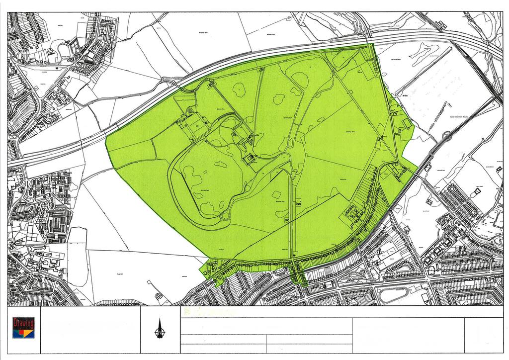
1 OSTERLEY PARK AND SURROUNDING AREA Boundary: See Map 13 Date of Designation: 19 April 1988 Date of Extension: None Additional protection to the area: Osterley Park House listed grade l; with subsidiary listed buildings, features and boundaries (many listed under the Jersey Road address). Park on the EH Register of Parks and Gardens of Special Historic Interest. The house and its estate is owned and managed by the National Trust. The park is Metropolitan Open Land. Some of the parkland, beyond the motorway, lies in the LB Ealing. Special Architectural and/or Historic Interest The main architectural and historic interest is Osterley House, its landscaped grounds and rural setting. Houses surrounding the perimeter of the park are also important to the conservation area because they reflect the suburban character of their time built around the railway, and their integrity of roofs and architectural features, and quality of materials and design form the setting of the Park. Some are older (in terraced form) relating to the earlier railway station and commercial neighbours; there are also relic farm settlement buildings and plot forms. History The recorded history of Osterley goes back to the time of Henry III ( ) when the woods of Osterlee were the resort of wild cattle and outlaws. The manor passed through many hands but it was not until Sir Thomas Gresham took it over in 1562 that the present structure of the park began to evolve. Gresham replaced the old farm house (possibly the present west wing of the stables) with a large manor house which it is said stood in the midst of a pleasant park, well-wooded and containing several fishponds. Gresham died in 1579 and over the next 200 years the house changed hands frequently. In 1711 the estate was sold to Sir Francis Child and it was his grandson (also called Francis) who began remodelling the house and engaged Robert Adam as the architect. The park and gardens surrounding the house were extensively altered during the rebuilding, the formal Elizabethan gardens being swept away and replaced by an informal 18th Century park. The design of the park has been attributed to Mrs Robert Child and her steward Mr Bunce, no landscape designer of note is known to have been employed. In 1804 Robert Child s granddaughter, Lady Sarah Sophia Fane, who inherited the estate, married the 5th Earl of Jersey and thus Osterley came into possession of the Jersey family. The 9th and present Earl, Lord Jersey, gave the house and grounds to the National Trust in The Osterley Conservation Area also includes some of the more interesting later 19th and also 20th Century surrounding streets developed after the coming of the railway. Character Appraisal Osterley Park House The conservation area is dominated by the house (Grade I), which stands in serene splendour in its park between the roaring traffic on the M4 and the Great West Road. The present regular exterior is mainly the result of Robert Adam s alterations of the 1760s-70s. The house consists of red brick wings of three storeys around a raised courtyard, with a taller tower with stone quoins and ogee cap projecting at each
2 corner. The courtyard is entered through a grand portico on the East side. The present exterior reflects the basic form of an Elizabethan house, but the façade is a later antiquarian creation. The portico is a highly successful adaptation of one of Adam s favourite motifs: a screen of columns to form a double portico, open on both sides, instead of backing onto a solid wall. It stands at the head of a flight of stairs boldly connecting outer space and inner courtyard space. The Portico of Octavia in Rome has been suggested as the classical source. On the opposite side of the house a curved double staircase with a typical Adam balustrade leads down to the garden. Park Buildings The brick U-shaped Stable Block (Grade I), North East of house, still looks largely Elizabethan despite later alterations to the doors and windows and the addition of the cupola, with a clock supplied in The West wing (Grade I) may well have been the original manor house that existed before Gresham s house with a polygonal star-turret in the North East corner. North West of the stable block lies Adam s Garden House (Grade II), designed about 1870, with a semicircular front of five linked Venetian windows. West of this is the Doric Temple of Pan (Grade II), with low Tuscan portico with eight columns, probably by William Chambers. The Chinese Temple in the lake (nearest the house) dates from Towards Ealing, cut off from the park by the motorway and also in separate ownership is a splendid Bridge (Listed grade II*) designed by Adam, now in a ruinous state. It has one large segmental arch, the central keystones with carved heads; flanking pairs of blocked columns. Park The formal setting shown in Rocque s Survey of London was swept away and replaced by an informal Landscape Park of lakes and scattered groups of trees. The series of serpentine lakes to the South and the East of the house were formed by damming a stream. The main approach road to the house from Osterley Lane followed a circuitous route designed to take advantage of various different views of the House through the trees and across the water. The main entrance was through lodges and gates at Wyke Green. Adam originally designed Lodges but these were replaced in the 19th Century, although the original gate piers (1775, Grade II) survive. The bridge across the northern-most lake, now buried in undergrowth, may have been of pedestrian importance as a footbridge connecting the two halves of the northern part of the park. This part of the park was called the Menagerie Park after the menagerie situated on the north-western shore of the lake. Mrs Child s menagerie was a great attraction of Osterley. Surrounding streets Jersey Road is the southern boundary of Osterley Park. For some distance the park wall edges the road. Some buildings to the east of the station have been constructed into a long established enclave within the natural boundary line of the park, as seen by the continuation of the enclosing wall. Large, but close-together mock-tudor style houses make a recent incursion at Hern Close, and houses line the Park along Alderney Avenue. For most of its length Jersey Road contains buildings of the early 20th century. These are mostly detached or semidetached and often half-timbered in appearance. Most
3 are good examples of their type although some have been altered or were developed when the new railway station opened on the Great West Road. They have larger gardens than others do outside the area, and boundary walls, which strengthen the country house setting. The larger gardens and low density with trees continue the open aspect, which makes the opportunity for and sight of trees, and gaps between roofs, of particular value; and shapes on the skyline important in general. Earlier buildings survive particularly around the former District Railway Station of Spring Grove and Osterley in Thornbury Road on the north side of the Great West Road. This area was developed around 1883 when the District Line ran between Hounslow and Acton Town. The character of this area together with its mature trees is more akin to the Spring Grove Conservation Area but the Great West Road has significantly separated them. However the small-scale commercial nature of the buildings lining the Park side of Thornbury Road is not repeated on the south, and with the old railway building and the rising ground to cross the railway line it has a particular charm of its own as of a small village street. The prevalence of woodland and trees increases towards the east, particularly along road edges and the railway line embankments. The golf course, playing and sports fields and relic walls and buildings such as those around Wyke Green extend the historic rural character of Osterley all the way to and including the Grand Union Canal, with its own special character, on the Ealing side as well as Hounslow s. The horrific noise blight of the motorway, and the supermarkets (particularly late-night) and rat-running traffic, are the main intruders into some otherwise remarkably peaceful places. Pressures on the area Needs for security and statutory requirements in conflict with the historic character and fabric of the House Need for alterations to improve viability of the House and park (and associated buildings) whilst maintaining historic imperatives Costs of repairs to Park s extensive boundary walls Motorway blight from noise Outside the Park: scale of proposed development because of high values, particularly extensions and alterations to rooflines, which can affect vistas and settings Erosion of setting through poor architectural quality of construction, especially pastiche with crude overlarge detailing using unsympathetic materials Infill of gardens by proposed development and extensions Erosion of the rural edge by increased demand for gates and walls, often inappropriate in style and material Potential erosion of long-distance views from as well as of the Park Loss of trees Potential To be evaluated at a later stage, but there is little potential immediately obvious, without harming the historic integrity of the park, and the character and scale of properties around. It might include:
4 Selective, sensitive and high quality design redevelopment, maintaining the characteristic form, spacing and scale, of existing properties that are not architecturally special. Enhancing the value of the shopping area by retaining mixed use Mending the boundary fabric where this has been eroded for hard-standings and encouraging appropriate edges and replanting Street tree planting Guiding principles In addition to statutory requirements, UDP principles and existing supplementary guidance, the following guidelines special to the area will be included in those to be evaluated: Preserve Osterley house extensions can have an effect on the park -formalised provides a village-street character Road should be avoided architectural quality ngs and scrub areas form part of the setting.

5
6
Supplementary Heritage Appraisal Syon & Osterley Parks
 Supplementary Heritage Appraisal Syon & Osterley Parks February 2017 Prepared by Montagu Evans All Ordnance Survey Plans are Crown Copyright. All rights reserved. Licence Number: 100007624 Copyright 2017.
CGT visit to Godolphin 11 th May 2016
 CGT visit to Godolphin 11 th May 2016 The garden at Godolphin Is one of Cornwall s most important medieval gardens and is on the national Register of Parks and Gardens as II*. The Register summary states
Urban Design Assessment
 3 Urban Design Assessment Page 27 3:1. Urban form Figure Ground The plan to the left is a 'figure ground' plan of the Southall area. This shows that Southall is a distinct place, surrounded by open land
Lincoln Townscape Assessment. Boultham Park Inherited Character Area Statement
 Lincoln Townscape Assessment Boultham Park Inherited Character Area Statement January 2008 Page 2 of 12 Table of Contents Page Overview 2 Historical Development 2 Urban form 3 Views 5 Condition of Buildings
Conservation Area Designation, amendments and Review
 Conservation Area Designation, amendments and Review Location: Any area largely confined to Park Road and St. James Avenue which includes the following properties: St. James Church, St. James Road; No.
National Character Area 70 Melbourne Parklands
 Summary The are a landscape of rolling farmland, parkland and woodland on the northern flanks of the ridge between Burton upon Trent and Swadlincote. The land slopes down to the River Trent, which borders
GARDENS AND ESTATES HORTON COUNTRY HOUSE LONGCROSS ESTATE LA GRANDE MAISON SUDELEY LAWN BARN NEAR BRIXWORTH WINGROVE HOUSE
 Our garden and estate work encompasses both traditional and contemporary design, informed by our skills in historic landscape conservation, and has been consistently well received. We like to work closely
Environmental and Landscape Mapping
 Environmental and Landscape Mapping In support of the Calveley Neighbourhood Plan November 2016 Project Name and Number: Calveley Neighbourhood Plan 16-025 Document Name and Revision: Environmental and
Ordnance Street 110 Plan OS Lot 413 B202; parts of Lot 412 and portion of Lot 413
 Ordnance Street 110 Plan OS Lot 413 B202; parts of Lot 412 and portion of Lot 413 110 Ordnance Street has cultural heritage value under 3 categories Physical built in 1886, it is an example of late 19
ENVIRONMENTAL AND LANDSCAPE MAPPING
 APPENDIX IV : Environmental and Landscape Mapping ENVIRONMENTAL AND LANDSCAPE MAPPING Calveley Neighbourhood Plan November 2016 ENVIRONMENTAL AND LANDSCAPE MAPPING Calveley Neighbourhood Plan Calveley
History of the Cranley Road Area. What is The Cranley Road Area
 History of the Cranley Road Area. What is The Cranley Road Area The Cranley Road Area lies to the east of Guildford. It was originally developed as large Victorian villas by the 4 th Earl of Onslow. It
Lancaster Conservation Area Appraisal. Character Area 8. Cathedral
 Lancaster Conservation Area Appraisal Character Area 8. Cathedral March 2013 118 3.8 Character Area 8. Cathedral 3.8.1. Definition of Special Interest "This character area is distinctive for the fine group
STRENSALL RAILWAY BUILDINGS CONSERVATION AREA APPRAISAL. In association with Strensall with Towthorpe Parish Council
 STRENSALL RAILWAY BUILDINGS CONSERVATION AREA APPRAISAL In association with Strensall with Towthorpe Parish Council CONTENTS Page 1 Introduction 2 2 Location and Context 3 3 Topography and Setting 4 4
Commenting on Planning Applications: MHPRA Policy
 Commenting on Planning Applications: MHPRA Policy millhillparkacton.org Our Area The Mill Hill Park Residents Association covers the Mill Hill Park Conservation Area in Acton, W3. Objectives We aim to
WELCOME TO THE NEW WILTON PARK
 WELCOME TO THE NEW WILTON PARK VISION HISTORY OF WILTON PARK TOWARDS A PLANNING APPLICATION Our objective is to create a truly outstanding environment at Wilton Park. At the heart of our proposals is a
MATURE SUBURBS RESIDENTIAL DEVELOPMENT GUIDELINES
 MATURE SUBURBS RESIDENTIAL DEVELOPMENT GUIDELINES DRAFT FEBRUARY 2005 BIRMINGHAM CITY COUNCIL 1 Introduction Mature Suburbs Residential Development Guidelines - Interim Supplementary Planning Advice -
Land to West of Bessel s Way, Blewbury. Contextual Analysis. fluid
 Land to West of Bessel s Way, Blewbury Contextual Analysis fluid Contents fluid - Overview - Growth pattern - Footpath & Road connections - Landscape Character - Amenities - Agriculture - Characteristic
DACORUM GOLDEN PARSONAGE Great Gaddesden Brief Description Principal Building: Approach: Stable block other utilitarian buildings: Walled Garden:
 HERTFORDSHIRE GARDENS TRUST LOCAL LIST: DACORUM Present Name of Site GOLDEN PARSONAGE Historic Name (if known) Parish/Town Great Gaddesden National Grid Reference of Principal Building: TL051 125 Present
East Riding Historic Designed Landscapes. 1.3 Administrative area: Bridlington Civil Parish, East Riding of Yorkshire Unitary Authority
 YORKSHIRE GARDENS TRUST East Riding Historic Designed Landscapes SEWERBY HALL Report by David and Susan Neave May 2013 1. CORE DATA 1.1 Name of site: Sewerby Hall, Sewerby 1.2 Grid reference: TA 203691
Conservation Area Designation, amendments and Review
 Conservation Area Designation, amendments and Review Location: No.s 37-49 (odd) Twickenham Road Date Assessed: January 2018 Adjacent Conservation Area Significance: Teddington Lock CA. The Teddington Lock
Case Studies; Meitheal Clusters Applied to Villages and Rural Settlements
 Case Studies; Meitheal Clusters Applied to Villages and Rural Settlements 23.3.9 (ii) Case Studies, Meitheal Clusters applied to villages and rural settlments Fig 22.3.12 Cluster site plan; church opposite
10. East Dulwich East Dulwich Area Vision
 10. 10.1. Area Vision 10.1.1. is: A predominantly residential area characterised by mostly medium density housing, including many family homes. Many parts of have retained historic character and it includes
8. Camberwell 8.1. Camberwell Area Vision
 8. 8.1. Area Vision 8.1.1. is: Centred on a medieval village centre which has become a thriving modern town centre surrounded by residential streets laid out in the Georgian era; Linked by rail to central
Gillingham Hall Norfolk
 Gillingham Hall Norfolk Figure 1. Engraving after a drawing by J S Cotman 1818 Impact assessment of proposed alterations NHER No. 10738 Stephen Heywood FSA Heritage and Landscape Norfolk County Council
Maesgwynne Hall Estate. Howey Nr Llandrindod Wells Powys
 Maesgwynne Hall Estate Howey Nr Llandrindod Wells Powys Maesgwynne Hall Estate Howey Nr Llandrindod Wells Powys ld1 5rn Exciting Sporting Estate in Mid Wales Exciting opportunity to acquire an historic
Parish Derry Slopes ITM Coordinates ; NG Coordinates C House B1 and farm buildings B2; Registered Garden L061
 Asset Ref No. HB/01/27/018A-C, Ballyarnett & Farm; Registered Historic Garden L061 Heritage Type Location Protection Status Condition Ownership (if known) Built Post-Medieval house & farm OS 6-inch map
Colchester Northern Gateway Master Plan Vision Review Draft. July 2016
 Colchester Northern Gateway Master Plan Vision Review Draft July 2016 Contents Introduction 4 Context 8 Purpose of the Report 8 Strategic Position 9 Overview of the Process 11 2012 Master Plan Vision 12
Capability Brown at Sherborne Castle
 Capability Brown at Castle Capability Brown s lake Castle Estates From 1753 Capability Brown landscaped the grounds at in two phases, creating the beautiful lake that dominates the park and later remodelling
Derry City and Strabane District Council Planning Committee Report
 Derry City and Strabane District Council Planning Committee Report COMMITTEE DATE: 23 rd March 2016 APPLICATION No: APPLICATION TYPE: PROPOSAL: LOCATION: APPLICANT: LA11/2015/0395/F Residential Development
UPPER GORDON ROAD TO CHURCH HILL, CAMBERLEY CONSERVATION AREA
 Introduction This leaflet explains the purpose of conservation areas and the implication of their designation for residents, property owners and the Council. It provides you with a plan of the area and
STATEMENT OF OBJECTION TO THE PROPOSED DEVELOPMENT OF LAND AT CHURCH CLIFF DRIVE FILEY
 STATEMENT OF OBJECTION TO THE PROPOSED DEVELOPMENT OF LAND AT CHURCH CLIFF DRIVE FILEY You will be aware that Scarborough borough council have adopted a new local plan that includes land at Church Cliff
HERITAGE STATEMENT AND IMPACT ASSESSMENT HILLBARK FARMHOUSE FRANKBY
 HILLBARK FARMHOUSE HERITAGE STATEMENT AND IMPACT ASSESSMENT HILLBARK FARMHOUSE FRONT ENTRANCE CONTENTS Executive summary 1.0 INTRODUCTION 1.1. Background to the report 1.2. Purpose of the Report 2.0 SIGNIFICANCE
To secure a Green Belt around Cambridge whose boundaries are clearly defined and which will endure for the plan period and beyond.
 4. GREEN BELT OBJECTIVES GB/a GB/b GB/c GB/d To secure a Green Belt around Cambridge whose boundaries are clearly defined and which will endure for the plan period and beyond. To maintain the purposes
The analysis of key visual characteristics and attributes that contribute to variations in the
 15.0 CHIGWELL/CHIGWELL ROW 15.1 Overview 15.1.1 Chigwell and Chigwell Row settlements are situated in the south of Epping Forest District, to the south of Abridge and southwest of Stapleford Abbotts. Both
INTRODUCTION CURRENT APPLICATION
 05/01805/FUL & 05/01807/LBC ERECTION OF A SINGLE DWELLING HOUSE WITH ANCILLARY ACCOMMODATION AT Flamingo Zoological Gardens, Olney Road, Weston Underwood FOR Mr A J Crowther (as amended by letter dated
3(iv)(b) TCP/11/16(29)
(b) TCP/11/16(29)") 3(iv)(b) TCP/11/16(29) TCP/11/16(29) Planning Application 09/02229/AML Erection of a dwellinghouse, garage with upper floor accommodation and stables (Approval of Matters Specified by Conditions) at land
3(iv)(b) TCP/11/16(29) TCP/11/16(29) Planning Application 09/02229/AML Erection of a dwellinghouse, garage with upper floor accommodation and stables (Approval of Matters Specified by Conditions) at land
Part 3 TYPE: BUNGALOW. 1910s 1930s
 RESIDENTIAL TYPES & STYLES Part 3 TYPE: BUNGALOW 1910s 1930s The bungalow is a twentieth-century residential type that arrived in New Orleans in the 1910s via California and the Arts and Crafts movement.
Osterley and Spring Grove 3. Hounslow Context & Character
 3 1 present-day context Transect (see below) X The Osterley and Spring Grove study area is located in the north-centre of the borough. It is crossed east-west by the Piccadilly and Hounslow Loop railway
East Riding Historic Designed Landscapes. Report by David and Susan Neave February 2013
 YORKSHIRE GARDENS TRUST East Riding Historic Designed Landscapes GRIMSTON GARTH Report by David and Susan Neave February 2013 1. CORE DATA 1.1 Name of site: Grimston Garth, East Garton 1.2 Grid reference:
I539. Smales 2 Precinct
 I539. Smales 2 Precinct I539.1. Precinct Description The Smales 2 Precinct applies to a 4.8 hectare block of land located on the southern side of Northcote Road and fronting Lake Pupuke, Takapuna. The
Appraisal of proposed alterations to the boundary of Helmsley Conservation Area
 Appraisal of proposed alterations to the boundary of Helmsley Conservation Area Elmslac Road: Elmslac Road was constructed in the early 1950s in two or three stages by the Helmsley Rural District Council.
GREENFORD HALL & ADJOINING LAND
 GREENFORD HALL & ADJOINING LAND CONTENTS 1. Introduction 1. Introduction 2. Urban Context 2.1 The Site and Surroundings 2.2 Urban Context Map 2.3 Access and Movement 3. Planning Context 3.1 Planning History
by Jennifer Tempest BA(Hons) MA PGDip PGCert Cert HE MRTPI IHBC an Inspector appointed by the Secretary of State for Communities and Local Government
 MA PGDip PGCert Cert HE MRTPI IHBC an Inspector appointed by the Secretary of State for Communities and Local Government") Appeal Decisions Site visit made on 19 January 2015 by Jennifer Tempest BA(Hons) MA PGDip PGCert Cert HE MRTPI IHBC an Inspector appointed by the Secretary of State for Communities and Local Government
Appeal Decisions Site visit made on 19 January 2015 by Jennifer Tempest BA(Hons) MA PGDip PGCert Cert HE MRTPI IHBC an Inspector appointed by the Secretary of State for Communities and Local Government
Paynes Farm Uplowman, Tiverton, Devon
 Paynes Farm Uplowman, Tiverton, Devon Paynes Farm Uplowman, Tiverton, Devon, EX16 7LY Tiverton about 5 miles Wellington about 15 miles Taunton about 19 miles Exeter about 22 miles (Distances are approximate)
4.3 Dudley Area Plan. Introduction. History and Existing Character. Desired Future Character for Dudley
 4.3 Dudley Area Plan Introduction The suburb of Dudley has developed as a result of various circumstances including its topography, history and mineral resources. Dudley development has been identified
CLAYTON PRIORY London Road Hassocks West Sussex BN6 9NE
 CLAYTON PRIORY London Road Hassocks West Sussex BN6 9NE CLAYTON PRIORY Clayton Priory is Listed Grade II*, being of particularly important 'historic and architectural interest', and is a superb example
List of Buildings of Local Architectural or Historic Interest BUCKHURST HILL PARISH
 List of Buildings of Local Architectural or Historic Interest BUCKHURST HILL PARISH 1. ST. STEPHEN'S CHURCH Albert Road /Buckhurst Way Attractive, albeit modest, late 19th century church (date stone 1876)
DESIGN GUIDANCE NOTE NO: 5 EXTENSIONS TO HOUSES
 DESIGN GUIDANCE NOTE NO: 5 EXTENSIONS TO HOUSES This note is one of a series providing design guidance for development in the borough. It explains the criteria used by the council to decide planning applications
Access not granted, notes and photographs from the street Sept (AB) Current Use
 Current Use") 1. Description of Property 49: 1248-1250 Lakeshore Road East, Grenvilla Lodge Municipal Address 1248-1250 Lakeshore Road East ame (if applicable) Grenvilla Lodge. (Incorrectly spelled in the Heritage Register
1. Description of Property 49: 1248-1250 Lakeshore Road East, Grenvilla Lodge Municipal Address 1248-1250 Lakeshore Road East ame (if applicable) Grenvilla Lodge. (Incorrectly spelled in the Heritage Register
NHS DUMFRIES & GALLOWAY - NITHBANK
 NHS DUMFRIES & GALLOWAY - NITHBANK Feasibility Options 19 March 2018 nithbank - site appraisal Site Analysis Set high on a terrace above a formal garden and the main road. This position and setting is
1 THE OLD VICARAGE MANOR ROAD F GORING ON THAMES F OXFORDSHIRE
 1 THE OLD VICARAGE MANOR ROAD F GORING ON THAMES F OXFORDSHIRE 1 THE OLD VICARAGE MANOR ROAD F GORING ON THAMES F OXFORDSHIRE Pangbourne on Thames 5 miles F Reading 10 miles F Newbury 13 miles F Oxford
Valley Farm Barn Combs Lane, Stowmarket, Suffolk
 Valley Farm Barn Combs Lane, Stowmarket, Suffolk Spin Valley Farm Barn, Combs Lane, Stowmarket, Suffolk, IP14 2NL Valley Farm Barn is situated on the periphery of Combs Ford, a small village south of the
Proposed Illustrative Masterplan Cumulative Revised Proposals. Properties
 Proposed Illustrative Masterplan Cumulative Revised Proposals Earls Court Project Application 2 Royal Borough of Kensington & Chelsea Environmental Statement, Volume II - Site Wide Development Option -
3.3. Urban Structure Defining a New Hierarchy of Routes and Spaces >Images
 Section 3.0 I The Masterplan Framework 18 >Images Examples of high quality routes and spaces 3.3. Urban Structure The success of any masterplan lies in a clear definition of the future urban structure
PLANNING COMMITTEE DATE: 07/09/2015 REPORT OF THE SENIOR MANAGER PLANNING AND ENVIRONMENT SERVICE CAERNARFON. Number: 4
 Number: 4 Application Number: C15/0034/37/LL Date Registered: 21/05/2015 Application Type: Full - Planning Community: Llanaelhaearn Ward: Llanaelhaearn Proposal: Location: Summary of the Recommendation:
PROJECT SITE The Proposed Project includes the Allen and Pike Street malls between Delancey and South Streets (see Figure 2C-1).
.") Chapter 2, Section C: A. INTRODUCTION This chapter considers the potential of the proposed Reconstruction of the Allen and Pike Street Malls project to affect the urban design characteristics and visual
Chapter 2, Section C: A. INTRODUCTION This chapter considers the potential of the proposed Reconstruction of the Allen and Pike Street Malls project to affect the urban design characteristics and visual
Tarn Lodge, Heads Nook, Brampton, CA8 9BT Guide price 645,000
 Tarn Lodge, Heads Nook, Brampton, CA8 9BT Guide price 645,000 Tarn Lodge, Heads Nook, Brampton, CA8 9BT Attached Grade II listed Regency dwelling providing generously proportioned accommodation set within
Warren Farm, Ampthill
 1 Welcome The developers of the Warren Farm site, Bloor Homes and Connolly Homes, are holding this exhibition on the emerging Design Codes for the development prior to their formal submission to Central
5.1 INTRODUCTION 5.2 EXISTING CONDITIONS
 Chapter 5: Aesthetic Resources 5.1 INTRODUCTION This chapter considers the potential of the Proposed Action to impact the visual character and aesthetic resources of the project area and the surrounding
DESIGN & ACCESS STATEMENT
 . DESIGN & ACCESS STATEMENT Site Adjacent to The Manor House, Upper Street,, Kingsdown, Deal, Kent. DESIGNS ARCHITECTURE + PLANNING CONTENTS Design and Access Statement Introduction Site and Location Planning
6. Ballintogher Mini-Plan
 County Development Plan 2017-2023 Consolidated Draft + Adopted Amendments August 2017 Volume 2, Chapter 6 Ballintogher Mini-Plan 6. Ballintogher Mini-Plan Village profile Ballintogher is located approximately
Chapter 27 Route Window SE7 Church Manorway Bridge. Transport for London
 Chapter 27 Route Window SE7 Church Manorway Bridge Transport for London CHURCH MANORWAY BRIDGE 27 Route Window SE7 Church Manorway bridge Introduction 27.1 The North Kent Line will be converted to four
1 Lady Cross Cottages, Hollow Lane, Dormansland, Lingfield, Surrey, RH7 6PB
 1 Lady Cross Cottages, Hollow Lane, Dormansland, Lingfield, Surrey, RH7 6PB Offers in Excess of 400,000 1 Lady Cross Cottages, Hollow Lane, Dormansland, Lingfield, Surrey, RH7 6PB Splendid Victorian end
FITZWILLIAM WENTWORTH ESTATE
 FITZWILLIAM WENTWORTH ESTATE Centred on the village of Wentworth in South Yorkshire, the Fitzwilliam Wentworth Estate is a substantial rural landholding with an immense history and a wealth of heritage.
Alresford Grange. a l r e s f o r d n c o lc h e s t e r n e s s e x
 Alresford Grange a l r e s f o r d n c o lc h e s t e r n e s s e x 1 2 Alresford Grange a l r e s f o r d n c o l c h e s t e r n e s s e x Superbly positioned Edwardian country house with exceptional
5 Gratton Terrace London NW2 6QE. Reference: 17/5094/HSE Received: 4th August 2017 Accepted: 7th August 2017 Ward: Childs Hill Expiry 2nd October 2017
 Location 5 Gratton Terrace London NW2 6QE Reference: 17/5094/HSE Received: 4th August 2017 Accepted: 7th August 2017 Ward: Childs Hill Expiry 2nd October 2017 Applicant: WSD (Gratton) Ltd Proposal: The
Euston Area Plan. Background Report Appendix 3. Proposed modifications (shown as tracked changes)
") Euston Area Plan Background Report Proposed modifications (shown as tracked changes) September 2014 . Testing the impacts of tall buildings on strategic and local views Introduction This appendix provides
Euston Area Plan Background Report Proposed modifications (shown as tracked changes) September 2014 . Testing the impacts of tall buildings on strategic and local views Introduction This appendix provides
Former Panshanger Aerodrome, Welwyn Garden City Masterplan Scenarios. Mariposa Investments
 Former Panshanger Aerodrome, Welwyn Garden City Masterplan Scenarios Mariposa Investments Contents 1.0 Introduction 1 2.0 The Site and Surroundings 2 3.0 Local Area Context 6 4.0 Site Features 10 5.0 Development
13. London Bridge London Bridge Area Vision
 13. 13.1. Area Vision 13.1.1. is: A globally significant central London business district which is home to international business headquarters; Internationally renowned for its prominent riverfront location
L 4-1. Heritage Report: Reasons for Heritage Designation. Kodors House. 35 Rosedale Avenue West
 L 4-1 Brampton Heritage Board Date: January 17, 2012 Heritage Report: Reasons for Heritage Designation Kodors House 35 Rosedale Avenue West December 2011 1 L 4-2 Profile of Subject Property Municipal Address
16. Peckham Peckham Area Vision
 16. 16.1. Area Vision 16.1.1. is: A lively town centre providing a range of daytime and night time activities on Rye Lane including a Library, a Leisure Centre and many independent retailers which specialise
PART 2 SOUTH DOWNS NATIONAL PARK AUTHORITY SECTION 1 SCHEDULE OF APPLICATION RECOMMENDATIONS
 42 PART 2 SOUTH DOWNS NATIONAL PARK AUTHORITY PLANNING COMMITTEE REPORT OF THE SERVICE MANAGER PLANNING DEVELOPMENT Applications to be determined by the council on behalf of the South Downs National Park
Eastern Golf Course, Doncaster Road, Doncaster
 , 463-535 Road, Heritage Assessment in accordance with Schedule to the Development Plan Overlay July 2013 bryce raworth conservation urban design 19 Victoria Street St Kilda Vic 3182 , 463-535 Road, Heritage
Sunday's Well Proposed Architectural Conservation Area
 1 Sunday's Well Proposed Architectural Conservation Area D A E C B F Old City Gaol Saint Vincent s RC Church Saint Albert s Former Good Shepherd Convent Boundary of Area Sunday's Well is an area located
About 10% of the Borough's population lives in the seven rural parishes. Population figures from the 1991 census are given below:-
 8. THE DISTRICT VILLAGES 8.1 Population About 10% of the Borough's population lives in the seven rural parishes. Population figures from the 1991 census are given below:- Village No. of Persons Cottingham
6. Bermondsey 6.1. Bermondsey Area Vision
 6. 6.1. Area Vision 6.1.1. is: An inner-london neighbourhood characterised by modest worker ho associated with the historic Rotherhithe docks and local manufacturing industries such as biscuits, jam, vinegar
CHAPTER 2: HISTORIC BACKGROUND
 CHAPTER 2: HISTORIC BACKGROUND The historic town of Eastlake was created on June 22, 1911 when the Eastlake Subdivision was recorded at the Adams County Clerk and Recorder s Office. The Eastlake Investment
THE PORT OF IPSWICH FROM RICHES TO RAGS AND BACK AGAIN An Illustrated talk given by John Field notes by Bob Allen
 IPSWICH BUILDING PRESERVATION TRUST AGM 28/10/15 THE PORT OF IPSWICH FROM RICHES TO RAGS AND BACK AGAIN An Illustrated talk given by John Field notes by Bob Allen After the formal business of the AGM was
Sandall Park, Doncaster
 Sandall Park, Doncaster History The site was marked as the Sandall Brick and Tile Works on the 1854 and 1892 OS maps. It appeared on the 1906, 1930 and 1937 1:2500 maps similarly marked but also disused.
PLANNING STATEMENT. Market House Market Place Kingston upon Thames KT1 1JS
 PLANNING STATEMENT To support planning and listed building consent applications for change of use from Class A1 shop and Class A3 cafe to Class A3 restaurant at: Market House Market Place Kingston upon
Conservation Area Designation, amendments and Review
 Conservation Area Designation, amendments and Review Location: Are area largely confined to Cowley Road and North Warpole Way and incorporating the following properties: No.s 2-120 (even) & 61 123 (odd)
Yorkshire Dales National Park Authority
 Yard 1 2 Plane Tree The Reading Room Yorkshire Dales National Park Authority Application Code: Committee Date: 08/12/2015 Location: Prospect, Und FW Blea Head Path Track Track Bridge Path Und New Cowside
2154 Dundas Street West Intention to Designate under Part IV, Section 29 of the Ontario Heritage Act
 STAFF REPORT ACTION REQUIRED 2154 Dundas Street West Intention to Designate under Part IV, Section 29 of the Ontario Heritage Act Date: February 2, 2009 To: From: Toronto Preservation Board Toronto and
East Harptree Landscape & Character Assessment
 East Harptree Landscape & Character Assessment Produced by East Harptree Parish Council in consultation with local residents September 2014 Contents The Parish of East Harptree: Objective Introduction
COURTHOUSE CAMPUS BARNSLEY Executive Summary March 2010
 COURTHOUSE CAMPUS BARNSLEY Executive Summary March 2010 Estell Warren Cartwright Pickard Buro Happold King Sturge BWA Barnsley Metropolitan Borough Council introduction Courthouse Campus is the last major
8.0 Design and Form of Development 43/
 42/ 8.0 Design and Form of Development 43/ Rothwells Farm, Golborne/ Development Statement Figure 7. Site Constraints Key 44/ Site Boundary 360 Bus Route/Stops Existing Trees Underground Water Pipe Sensitive
MEDLANDS FARM Combe Lane, Shere, Guildford, Surrey
 MEDLANDS FARM Combe Lane, Shere, Guildford, Surrey MEDLANDS FARM Combe Lane, Shere Guildford, Surrey GU5 9TD SHERE VILLAGE - 0.75 mile Guildford (Waterloo 38 mins) - 5 miles Set in 37 acres of pastureland
Toddington Central Bedfordshire Stage 3 Green Belt Study December 2017
 Toddington Central Bedfordshire Stage 3 Green Belt Study December 2017 Site: ALP086 - Middle Lakes, Toddington Site size (ha): 2.83 Site: ALP086 - Middle Lakes, Toddington Site size (ha): 2.83 Site description
INTRODUCTION. Land south of Bishopswood Lane, Tadley
 0 INTRODUCTION THE SITE Introduction Gladman Developments Ltd. has successfully invested in communities throughout the UK over the past 0 years, developing high quality and sustainable residential, commercial
THE OLD RECTORY CLAVERTON BATH BA2 7BG
 THE OLD RECTORY CLAVERTON BATH BA2 7BG THE OLD RECTORY CLAVERTON BATH BA2 7BG A HANDSOME AND HISTORIC FORMER RECTORY WITH ANCILLARY ACCOMMODATION, SET IN A DELIGHTFUL VILLAGE CLOSE TO BATH ACCOMMODATION
Ashtead Neighbourhood Forum Site Assessment AS03 Lime Tree Lodge, Farm Lane. Site address: Lime Tree Lodge, Farm Lane. Proposed Land Use:
 Site ref: AS03 Site address: Lime Tree Lodge, Farm Lane Proposed Land Use: Total Site Area (Ha): Housing 1.25ha Description The site is located off Farm Lane at the junction with Park Lane. To the north
12. Herne Hill and North Dulwich Herne Hill and North Dulwich Area Vision
 12. 12.1. Area Vision 12.1.1. is: A residential neighbourhood which spans Southwark and Lambeth with many buildings of historic interest including the arts and crafts Sunray Estate and Stradella Road Conservation
24 Park Crescent. Exploring Abergavevnny
 24 Park Crescent Exploring Abergavevnny Cover: Park Crescent and the Blorenge 2 park crescent EXPLORING ABERGAVENNY For several years the Abergavenny and District Civic Society has been studying the streets,
Exploring Abergavenny
 11 Majors Barn36 Ysguborwen Exploring Abergavenny 2 ysguborwen EXPLORING ABERGAVENNY For several years the Abergavenny and District Civic Society has been studying the streets, spaces and buildings of
Broad Oak Farm, Sweechgate, Broad Oak, Canterbury, Kent
 Broad Oak Farm, Sweechgate, Broad Oak, Canterbury, Kent Broad Oak Farm Sweechgate, Broad Oak, Canterbury, Kent CT2 0QR A fine family home set in a large, established garden within easy reach of Canterbury.
9 VALLEY CLOSE GORING ON THAMES F SOUTH OXFORDSHIRE
 9 VALLEY CLOSE GORING ON THAMES F SOUTH OXFORDSHIRE 9 VALLEY CLOSE GORING ON THAMES F SOUTH OXFORDSHIRE Goring (London Paddington within the hour) F Streatley High Street/River - ½ miles F Reading - 10
SANDPIT FARM BRUISYARD 8 SUFFOLK
 SANDPIT FARM BRUISYARD 8 SUFFOLK SANDPIT FARM Bruisyard, Suffolk GRADE II LISTED COUNTRY HOUSE OFF A QUIET COUNTRY LANE SURROUNDED BY UNDULATING COUNTRYSIDE WITH ATTRACTIVE GARDENS, STUDIO ANNEXE, TRADITIONAL
Moor Hall Stoke by Clare, Suffolk
 Moor Hall Stoke by Clare, Suffolk Moor Hall, Stoke by Clare, Sudbury, Suffolk CO10 8HJ Stoke by Clare is a pretty and highly regarded village. Picturesque cottages and houses surround the village green
Winkenhurst Manor. Hellingly, East Sussex
 Winkenhurst Manor Hellingly, East Sussex Winkenhurst Manor NORTH STREET, HELLINGLY, EAST SUSSEX BN27 4EB An immaculately presented Grade II* listed house, together with excellent ancillary accommodation,
DEANS HALL FARM BREWOOD STAFFORD
 DEANS HALL FARM BREWOOD STAFFORD DEANS HALL FARM HYDE MILL LANE BREWOOD STAFFORD ST19 9DJ A fine, Grade II listed residence standing within beautiful gardens an grounds, with a total area of almost three