URBANDALE CONSTRUCTION PHASE 4B 4450 LIMEBANK ROAD PLANNING RATIONALE FOR SITE PLAN CONTROL. May Prepared for:
|
|
|
- Emma Oliver
- 5 years ago
- Views:
Transcription
1 URBANDALE CONSTRUCTION PHASE 4B 4450 LIMEBANK ROAD PLANNING RATIONALE FOR SITE PLAN CONTROL Prepared for: URBANDALE CONSTUCTION 2193 Arch Street Ottawa, Ontario K1G 2H5 Prepared by: J.L. RICHARDS & ASSOCIATES LIMITED 864 Lady Ellen Place Ottawa, Ontario K1Z 5M2 JLR 24870
2 URBANDALE CONSTRUCTION PHASE 4B PLANNING RATIONALE - TABLE OF CONTENTS - PAGE 1.0 INTRODUCTION Purpose Site Context Location and Site Description Community Context Road Widening THE PROPOSAL Site Plan Control Application Minor Variance Being Requested POLICY CONTEXT Planning Act, R.S.O. 1990, CHAPTER P Provincial Policy Statement (2014) The City of Ottawa Official Plan Riverside South Community Design Plan Regional Road Corridor Design Guideline City of Ottawa Zoning By-law CONCLUSION LIST OF APPENDICES - APPENDIX A Reduced Site Plan APPENDIX B Reduced Building Elevations APPENDIX C Review of Planning Act APPENDIX D Review of Provincial Policy Statement (20014) APPENDIX E Review of City of Ottawa Official Plan APPENDIX F Review of Riverside South Community Design Plan APPENDIX G Review of Regional Road Corridor Design Guideline APPENDIX H Review of City of Ottawa Zoning By-law JLR i J.L. Richards & Associates Limited

3 URBANDALE CONSTRUCTION PHASE 4B PLANNING RATIONALE 1.0 INTRODUCTION J.L. Richards & Associates Limited (JLR) has been retained by to prepare a planning rationale in support of a Site Plan Control application for the property located at 4450 Limebank Road (known as Urbandale Phase 4B) in the Former Township (City) of Gloucester, City of Ottawa as shown on Figure 1. This application seeks to permit the development of a Planned Unit Development consisting of 4, low rise residential dwelling buildings, each containing 16 dwelling units as shown in Appendix A. The proposed site plan is to be developed in accordance with the proposed updates to the Riverside South Community Design Plan (CDP), Figure 1 Aerial view of Riverside South: Phase 4B JLR J.L. Richards & Associates Limited
4 1.1 PURPOSE This Report will demonstrate how the development will be consistent with the Provincial Policy Statement, in conformity with the City of Ottawa Official Plan as implemented by the Riverside South CDP. This rationale also demonstrates that this proposal conforms to the Zoning By-law subject to a minor variance application that will be sought for the buildings to allow a proposed height of 18.0 metres. The layout will ensure the protection of environmental lands and provide for a higher residential density that meets the needs of both this growing community and the City as a whole. 1.2 SITE CONTEXT Location and Site Description The legal description of the Subject Site is Part of Lot 19, Concession 1, Rideau Front, in the Former Township (City) of Gloucester, now the City of Ottawa. The property is approximately 3.7 ha in size and is situated southwest of the Limebank/Spratt Road intersection and it fronts on Limebank Road. As shown in Figure 1, the site currently consists of undeveloped urban lands. These lands were previously rezoned to Residential Fourth Density (R4Z) and Open Space (O1) (refer to Section 3.5 and Figure 5) to allow for a range of dwelling types including: singles, semi s, towns and low-rise residential apartments Community Context The Subject Site is located within the Riverside South Community (RSC), with Phase 4 of the Subdivision immediately to the west, and Phase 5 to the east. There is also an existing hydro facility immediately opposite the site on Limebank Road. Mosquito Creek and a tributary (Tributary 2) to the main creek, travel through the southwestern half of the Subject Site. This natural feature also bounds both the northern and southern lots lines of the Site. The Subject Site is in close proximity to educational facilities and commercial and natural amenities. It is located approximately 570 metres north of Earl Armstrong Road and the Community Core Area of Riverside South (Phases 6 and 7). Spratt Road is approximately 280 metres to the north of the Subject Site. JLR J.L. Richards & Associates Limited
5 The lands immediately to the north of the Subject Site have been developed as a neighbourhood plaza. Those lands are zoned as General Mixed Use (GM [1758]). The Site Plan for development of the commercial plaza on these lands was approved by the City of Ottawa in 2011, as shown on Figure 2. Figure 2 Surrounding Context: Phase 4B JLR J.L. Richards & Associates Limited
6 Vacant lands and a high school are located in the north and east quadrant of Limebank and Spratt Road. The lands immediately to the west and south of the Subject Site have been zoned as Open Space as a part of the development of Phase 4. There is an existing storm pond to the south, and to the west, on the opposite side of Mosquito Creek. Beyond the Open Space Zone is the Phase 4 residential development (4M- 1448). This site is to be developed in a manner that implements the Community Design Plan, the City's Official Plan, and respects the intent of the Transportation Master Plan, the Infrastructure Master Plan and the Provincial Policy Statement The Subject Site includes a private street as shown on Figure 2 and detailed in Appendix A. This street will tie into Limebank Road at an unsignalized intersection which will only allow for right turning traffic movements. Limebank Road is classified as an arterial road in the Official Plan and Riverside South Community Design Plan. OC Transpo route 99 travels on Limebank and Spratt Roads, less than 350 m northwest of the Subject Site. In addition, rapid transit is planned for the Riverside South Community and will be within 1 km of the Subject Site Road Widening To accommodate the planned growth in the Riverside South Community, Limebank Road, an existing arterial road, has been widened to four lanes, plus turning lanes. The road widening process required additional lands for the right-of-way, including lands from the Subject Site. The proposed development concept for these lands has taken this fact into account. 2.0 THE PROPOSAL 2.1 Site Plan Control Application Appendix A is the site plan for the proposed development. This Planned Unit Development consists of 4, four storey residential buildings, each containing 16 dwelling units totaling 64 units. Proposed building elevations can be found in Appendix B. Due to issues regarding the unstable slopes in the Mosquito Creek valley, a Geotechnical investigation identified three hazard constraints on the Subject Site. JLR J.L. Richards & Associates Limited
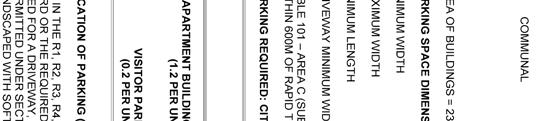
7 Appendix A includes the various constraints as identified by the Geo-technical Engineer. In most instances the 15 metre offset from the top of slope is the most restrictive. These hazard limits were used to establish the boundary of the current R4Z zone and to restrict the location of the proposed buildings. The site plan for the Subject Site was also designed to protect new development from these natural hazards by not proposing any units within even the most restrictive of the hazards identified on the site. The Site Plan for the development has been designed around the appropriate development limit based on these natural constraints. Municipal water, sanitary sewer and stormwater sewer services are available in Limebank to service the Subject Site. A site servicing plan and report accompanies this submission. As shown in Appendix A, vehicular access to the Subject Site s private internal street will be from Limebank Road. The intersection of this private street and Limebank Road will not be signalized. The median proposed to bisect Limebank Road will restrict movement from the project property to right turning traffic only. No left turning movements onto or off of the site will be permitted. This private street is proposed to be a cul-de-sac to maximize development of the site. The proposed site will also include: - 64 bicycle parking spaces - 42 outdoor parking spaces - 64 underground parking spaces (16 per building) - 6 accessible parking spaces (2 outdoor and 4 underground) - 1 private internal streets (minimum widths of 7.5m and 6.3 m) - 4 driveways to underground parking areas (minimum width of 6.7 m) - 1 driveway to the above ground parking area (minimum width of 6.3 m) - 1 designated landscaped outdoor amenity area (designed in accordance with Section 137 of Zoning By-law) - 1 garbage enclosure to serve all four buildings (designed in accordance with - Section 110 of Zoning By-law) - 4 stormwater retention ponds 2.2 Minor Variance Being Requested The following variance will be sought concurrently with the Site Plan Approval process: JLR J.L. Richards & Associates Limited
8 1. To permit an increased building height of 18.0 metres, whereas the By-law permits a maximum building height of 15 metres for lands zoned R4Z. Variance 1 The four proposed residential apartment buildings have been designed in order to reflect and complement the building character of the surrounding lower density residential neighbourhood. This design includes the use of a pitched roof as opposed to a flat roof which is typically used in lower density residential neighbourhoods. As a result, the proposed buildings are 18.0 m in height, metres over the maximum permitted 15 metres. 3.0 POLICY CONTEXT 3.1 Planning Act (R.S.O. 1990, CHAPTER P.13) Section 41 (4) of the Planning Act provides details regarding the development criteria to be considered with a Site Plan Control application. Please see Appendix C for the detailed review of the Section 41 development criteria. The proposed Site Plan for Phase 4B has addressed all of the criteria identified in the Act. This rationale confirms our opinion that the proposed site plan has met the criteria identified in the Act and is appropriate for development. 3.2 Provincial Policy Statement (2014) This Site Plan is consistent with the vision and ideas of the Provincial Policy Statement (PPS) as issued under Section 3 of the Planning Act. For example, Section 1.1 of the PPS focuses on promoting efficient land use and development patterns that occur adjacent to built-up areas and which provide opportunities for intensification. It is our opinion that this proposal is consistent with the PPS, Please see Appendix D for the detailed review of the relevant PPS policies. 3.3 The City of Ottawa Official Plan The City of Ottawa Official Plan, adopted by City Council in May 2003, has been updated and amended numerous times by both Council and the Ontario Municipal Board. For the purposes of this planning rationale, the on-line consolidated version of the Official Plan, including Amendment # 150, was used as reference. JLR J.L. Richards & Associates Limited
 within the Urban Area.")
9 The Subject Site is located within the urban boundary of the City of Ottawa and is part of the settlement area for the City. Schedule B of the Official Plan shows the site designated as a General Urban Area and Major Open Space (refer to Figure 3) within the Urban Area. Figure 3 Existing City of Ottawa Official Plan Schedule B: General Urban Area and Major Open Space The proposed Site Plan was created with special consideration for the policies of the General Urban Area, Strategic Directions in the Official Plan and based upon the required technical studies, in particular, those related to protection against hazards (creek lands), and the increased density on the arterial road. Please see Appendix E for the detailed review of the relevant Official Plan policies. 3.4 Riverside South Community Design Plan The CDP was approved by the City of Ottawa Council in June The CDP was amended in 2010 and is proposed to be amended in early In accordance with the City s Official Plan policies; the preparation of a CDP was required before development proceeds in areas designated Developing Community. JLR J.L. Richards & Associates Limited
.")
10 The development portion of the Subject Site is designated for Medium Density Residential (MD) purposes and the remainder is Valley Lands (VL) to be preserved as required by the Riverside South CDP (shown in Figure 4). Figure 4 Riverside South CDP Land Use Schedule: Phase 4B The proposed Site Plan was development in accordance with the CDP including the provisions related to built form, design guidelines, density targets for medium density areas and natural features and open spaces. Please see Appendix F for the detailed review of the CDP policies. As shown on the proposed elevation drawings in Appendix B, all elevations of the buildings façades have been designed to be highly articulated with detailed entrance features and window detailing. 3.5 Regional Road Corridor Design Guideline The Regional Road Corridor Design Guideline (2000) is a guideline used by the City to complement existing guidelines and regulations for the design of new and reconstructed Regional roads and of adjacent land uses. The intent of this guideline is to respect JLR J.L. Richards & Associates Limited

11 traditional design objectives for safety, efficiency, capacity, and maintenance, while integrating objectives relating to compatibility, livability, community building, urban design, cost and environmental impacts. As identified in this guideline, Limebank Road is considered to be a Regional Road. The proposed Site Plan was developed using the directions from the Regional Road Corridor Design Guideline including the provisions related to building design and orientation. Please see Appendix G for the detailed review of the relevant Regional Road Corridor Design Guideline policies. 3.6 City of Ottawa Zoning By-law The Subject Site is currently zoned R4Z Residential Fourth Density, Sub Zone Z in the City of Ottawa Comprehensive Zoning By-law as shown on Figure 5. Figure 5 City of Ottawa Zoning By-law : Phase 4B The proposed Site Plan has been designed to comply with the zoning standards of the R4Z zone and all other relevant provisions including the General, Parking and Residential requirements with exception to the maximum allowed building height. Due to JLR J.L. Richards & Associates Limited

12 increased floor to ceiling heights of the proposed buildings as well as their consistent roof design to other residential structures in the area, they exceed the maximum permitted height of 15 metres. As a result, a minor variance will be sought for the buildings which are proposed to be 18.0 metres high. The site plan includes a detailed table demonstrating conformity. Please see Appendix H for the detailed review of the relevant Zoning By-law policies and standards. 4.0 CONCLUSION This Report has been prepared in support of an application for a Site Plan Control application for Phase 4B which will see a new a Planned Unit Development consisting of 4, four storey residential dwelling buildings, each containing 16 dwelling units. 1. The current site plan control application is consistent with the Provincial Policy Statement, 2014 as the proposed development is located within a designated Settlement Area, is compatible with its surroundings and is consistent with the provincial interest identified in the Provincial Policy Statement. 2. The application respects the provisions of the Official Plan and the adopted Riverside South CDP which has identified these lands as General Urban and Medium Density Residential. This proposal conforms to the intent of this designation in that higher density of residential development is being proposed. 3. The proposed development conforms to the provisions of the R4Z zone which allows for the development of a Planned Unit Development and Apartment Buildings. A minor variance application will be sought for the proposed building heights. Based on the above noted rationale the application for site plan control for the Subject Site is appropriate and represents good land use planning. Prepared by: Reviewed by: Katie Morphet, MCIP, RPP Timothy F. Chadder, MCIP, RPP JLR J.L. Richards & Associates Limited
13 A P P E N D I X A REDUCED SITE PLAN JLR J.L. Richards & Associates Limited
14
15 A P P E N D I X B REDUCED BUILDING ELEVATIONS JLR J.L. Richards & Associates Limited
16
17
18
19
20 A P P E N D I X C REVIEW OF PLANNING ACT JLR J.L. Richards & Associates Limited
21 Planning Act, R.S.O, 1990 (Not including Bill 73 No Royal Assent) Section 41 of the Planning Act provides the legal framework from establishment of Site Plan Control Areas, approvals of plans or drawings and conditions for approval of plans or drawings. Approval of plans or drawings (4) No person shall undertake any development in an area designated under subsection (2) unless the council of the municipality or, where a referral has been made under subsection (12), the Municipal Board has approved one or both, as the council may determine, of the following: 1. Plans showing the location of all buildings and structures to be erected and showing the location of all facilities and works to be provided in conjunction therewith and of all facilities and works required under clause (7) (a), including facilities designed to have regard for accessibility for persons with disabilities. The site plan for the Subject Site was designed showing the location of all buildings and structures, the location of all facilities and works to be provided in conjunction therewith and of all facilities and works including facilities designed to have regard for accessibility for persons with disabilities. 2. Drawings showing plan, elevation and cross-section views for each building to be erected, except a building to be used for residential purposes containing less than twenty-five dwelling units, which drawings are sufficient to display, (a) the massing and conceptual design of the proposed building; (b) the relationship of the proposed building to adjacent buildings, streets, and exterior areas to which members of the public have access; (c) the provision of interior walkways, stairs, elevators and escalators to which members of the public have access from streets, open spaces and interior walkways in adjacent buildings; (d) matters relating to exterior design, including without limitation the character, scale, appearance and design features of buildings, and their sustainable design, but only to the extent that it is a matter of exterior design, if an official plan and a by-law passed under subsection (2) that JLR J.L. Richards & Associates Limited
22 both contain provisions relating to such matters are in effect in the municipality; (e) the sustainable design elements on any adjoining highway under a municipality s jurisdiction, including without limitation trees, shrubs, hedges, plantings or other ground cover, permeable paving materials, street furniture, curb ramps, waste and recycling containers and bicycle parking facilities, if an official plan and a by-law passed under subsection (2) that both contain provisions relating to such matters are in effect in the municipality; and (f) facilities designed to have regard for accessibility for persons with disabilities. R.S.O. 1990, c. P.13, s. 41 (4); 2002, c. 9, s. 56 (1); 2006, c. 23, s. 16 (3, 4); 2009, c. 33, Sched. 21, s. 10 (9). The elevation drawings found in Appendix B incorporate all of the requirements of Section41 (4)(2) of the Planning Act. Conditions to approval of plans (7) As a condition to the approval of the plans and drawings referred to in subsection (4), a municipality may require the owner of the land to, (a) provide to the satisfaction of and at no expense to the municipality any or all of the following: 1. Subject to the provisions of subsections (8) and (9), widenings of highways that abut on the land. 2. Subject to the Public Transportation and Highway Improvement Act, facilities to provide access to and from the land such as access ramps and curbings and traffic direction signs. 3. Off-street vehicular loading and parking facilities, either covered or uncovered, access driveways, including driveways for emergency vehicles, and the surfacing of such areas and driveways. 4. Walkways and walkway ramps, including the surfacing thereof, and all other means of pedestrian access. 4.1 Facilities designed to have regard for accessibility for persons with disabilities. 5. Facilities for the lighting, including floodlighting, of the land or of any buildings or structures thereon. JLR J.L. Richards & Associates Limited
23 6. Walls, fences, hedges, trees, shrubs or other groundcover or facilities for the landscaping of the lands or the protection of adjoining lands. 7. Vaults, central storage and collection areas and other facilities and enclosures for the storage of garbage and other waste material. 8. Easements conveyed to the municipality for the construction, maintenance or improvement of watercourses, ditches, land drainage works, sanitary sewage facilities and other public utilities of the municipality or local board thereof on the land. 9. Grading or alteration in elevation or contour of the land and provision for the disposal of storm, surface and waste water from the land and from any buildings or structures thereon; The proposed development for the Subject Site has already provided a road widening to the municipality and will provide the additional features as found under Section 41 (7) of the Planning Act: facilities to provide access to and from the land such as curbings and traffic direction signs; off-street vehicular loading and parking facilities, covered and uncovered; asphalt access driveways, including driveways for emergency vehicles; concrete walkways and walkway ramps; facilities designed to have regard for accessibility for persons with disabilities (including accessible parking spaces); site lighting; central storage enclosures for the storage of garbage and other waste material; easements will be conveyed to the municipality for the construction, maintenance or improvement of land drainage works, sanitary sewage facilities and other public utilities of the municipality on the land; and grading of the site elevation and provision for the disposal of storm, surface and waste water from the land and from any buildings or structures thereon JLR J.L. Richards & Associates Limited
24 A P P E N D I X D REVIEW OF PROVINCIAL POLICY STATEMENT (2014) JLR J.L. Richards & Associates Limited
25 Provincial Policy Statement (2014) This Site Plan is consistent with the vision and ideas of the Provincial Policy Statement (PPS) as issued under Section 3 of the Planning Act. Section 1.1 of the PPS focuses on promoting efficient land use and development patterns that occur adjacent to built-up areas and which provide opportunities for intensification. Section states: Settlement Areas shall be the focus of growth and their vitality and regeneration shall be promoted. The proposed development of the Subject Site promotes growth within the Community of Riverside South by adding 64 units. The proposed residential development is a logical and anticipated extension (as per the Community Design Plan) of the surrounding neighbourhoods and will foster fluid connections within the community of Riverside South. Section of the Provincial Policy Statement states: Land use patterns within settlement areas shall be based on: a) densities and a mix of land uses which: 1. efficiently use land and resources; 2. are appropriate for, and efficiently use, the infrastructure and public service facilities which are planned or available, and avoid the need for unjustified and/or uneconomical expansion; Section of the Provincial Policy Statement states: New development taking place in designated growth area should occur adjacent to the existing built-up area and shall have a compact form, mix of uses and densities that allow for the efficient use of land, infrastructure and public service facilities. The PPS promotes the development of areas where infrastructure is already in place. The PPS supports a range of housing types and Section indicates that: Planning authorities shall provide for an appropriate range of housing types and densities to meet projected requirements of current and future residents of the regional market area by: JLR J.L. Richards & Associates Limited
26 a) establishing and implementing minimum targets for the provision of housing which is affordable to low and moderate income households.; d) promoting densities for new housing which efficiently use land, resources, infrastructure and public service facilities, and support the use of alternative transportation modes and public transit in areas where it exists or is to be developed; The development proposal for Phase 4B supports the goals of the PPS Section 1.1 as outlined in in that it provides a higher density form of housing within the developing area of the Riverside South Community. Existing infrastructure is in place to service the development, and transportation networks are already established and well-used. The Servicing Brief that has been prepared in support of this application confirms this. Further, this proposal will provide a range of housing in keeping with the policies of the PPS. JLR J.L. Richards & Associates Limited
27 A P P E N D I X E REVIEW OF CITY OF OTTAWA OFFICIAL PLAN (Including O.P.A #150 as it has been Council Approved) JLR J.L. Richards & Associates Limited
28 City of Ottawa Official Plan, 2003 The City of Ottawa Official Plan, adopted by City Council in May 2003, has been updated and amended numerous times by both Council and the Ontario Municipal Board. For the purposes of this planning rationale, the on-line consolidated version of the Official Plan, including Amendment # 150, was used as reference. The Subject Site is located within the urban boundary of the City of Ottawa and is part of the settlement area for the City. Schedule B of the Official Plan shows the site location in the south part of the City of Ottawa designated as a General Urban Area and Major Open Space (refer to Figure 3) within the Urban Area. Section of the Official Plan provides a framework for the General Urban Area. The Plan states that: The General Urban Area designation permits the development of a full range and choice of housing types to meet the needs of all ages, incomes and life circumstances, in combination with conveniently located employment, retail, service, cultural, leisure, entertainment and institutional uses. This will facilitate the development of complete and sustainable communities. A broad scale of uses is found within this designation, from ground-oriented single-purpose to multi-storey mixed-use; from corner store to shopping centre. While the City is supportive of the establishment of a broad mix of uses in Ottawa's neighbourhoods, this is not meant to imply that all uses will be permitted everywhere within areas that are designated General Urban Area. The zoning bylaw will continue to regulate the location, scale and type of land use in accordance with the provisions of this Plan. Within neighbourhoods, the zoning by-law will allow those uses that provide for the local, everyday needs of the residents, including shopping, schools, recreation and services. Uses that also serve wider parts of the city will be located at the edges of neighbourhoods on roads where the needs of these land uses (such as transit, car and truck access, and parking) can be more easily met and impacts controlled. Subject to the policies below, the City supports infill development and other intensification within the General Urban Area in a manner that enhances and complements the desirable characteristics and ensures the long-term vitality of the many existing communities that make up the city. Section of the Official Plan provides a framework for Major Open Spaces. The Plan states that: JLR J.L. Richards & Associates Limited
29 Major Open Spaces are large parks such as Walter Baker Park, open space corridors along the Ottawa and Rideau Rivers and the Rideau Canal, parkway corridors and corridors reserved for rapid-transit and major roads. Most Major Open Spaces are already in public ownership. The Rideau River and Canal are national historic sites and development of marinas on adjacent lands requires approval of Parks Canada. Major Open Spaces are a key component of the Greenspace Network (see Section 2.4), which contributes to the quality of life in neighbouring communities as well as to the overall integrity of the natural environment. The proposed Site Plane was created with special consideration for the policies of the General Urban Area, Strategic Directions in the Official Plan and based upon the required technical studies. Implementation of all of the relevant policies regarding the General Urban Area (found in Section of the Official Plan), the Major Open Spaces (found in Section of the Official Plan) and the Strategic Directions (found in Section 2), were then considered as a part of the development of the revisions to the CDP. The proposed Site Plan and current zoning are the proper reflection of these policies as refined in the supporting studies. Constraints Phase 4B is located amongst several natural constraints that have influenced the zoning, and now, the design of the Site Plan. The most obvious natural feature is Mosquito Creek and the tributary to the main creek, which are located on the Subject Site. Due to issues regarding the unstable slopes in the Mosquito Creek valley, a Geotechnical investigation identified 3 hazard constraints on the Subject Site. Appendix A includes the various constraints as identified by the Geo-technical Engineer. In most instances the 15 metre offset from the top of slope is the most restrictive. These hazard limits were used to establish the boundary of the current R4Z zone and to restrict the location of new dwellings, as shown on Figure 5. The site plan for the Subject Site was also designed to protect new development by not proposing any units within the most restrictive of the hazards identified on the site. The Site Plan for the development has been designed around the appropriate development limit based on these natural constraints. JLR J.L. Richards & Associates Limited
30 A P P E N D I X F REVIEW OF RIVERSIDE SOUTH COMMUNITY DESIGN PLAN (2010 and the proposed amendment (2016)) JLR J.L. Richards & Associates Limited
31 Riverside South Community Design Plan The CDP was approved by the City of Ottawa Council in June The CDP was amended in 2010 and is proposed to be amended in early In accordance with the City s Official Plan policies; the preparation of a CDP was required before development proceeds in areas designated Developing Community. The guiding principle for the CDP is: The Community Design Plan for Riverside South is guided by transitoriented development principles that seek to achieve efficient land use patterns, while creating a community where residents have access to open spaces, shops, schools, community services, and choices in dwelling types in a high quality urban environment. Job opportunities in designated employment lands and throughout the community will help to achieve a balance between jobs and households in the new community. These policies were developed in keeping with the Urban Design Guidelines for Greenfield Neighbourhoods. The CDP was analyzed to determine the most appropriate way to modify the Land Use Plan, to implement the objectives of the CDP, once the revised woodlot has been defined. The primary objectives of the CDP are to: - support transit-oriented development focused on the rapid transit corridor; - create land use and road patterns that support various modes of transportation; - maximize the benefits from existing natural features; - create a network of open spaces accessible to residents and visitors; - establish a range of residential densities and foster a mix of unit types; - ensure consistent treatment of buildings, street edges, boulevards, landscape areas and open spaces; and - encourage the development of an attractive, mixed use Community Core area. JLR J.L. Richards & Associates Limited
32 The Subject Site is designated for Medium Density Residential purposes and Valley Lands in the Riverside South CDP as shown in Figure 4. Site and Built Form Guidelines Section of the Riverside South CDP outlines design guidelines for apartment style buildings: Apartment Buildings a. Siting Criteria i. Buildings should be oriented to a public street. ii. Main building entries must face onto the public sidewalk and be directly accessible from the sidewalk. b. Elevations i. Building façades should be highly articulated; entry features, window detailing, variation of rooflines and change of planes should be used. ii. Within mixed-use areas, façade materials and colours should reflect the residential nature of the building. iii. All elevations should have the same degree of architectural treatment. iv. Buildings on corner sites should highlight the corner through massing and the use of special architectural features, such as towers, change of planes and/or change in material and colours. v. On retail streets, buildings should be coordinated in architectural design, including materials, colours and height. In order to facilitate the medium density targets of the CDP on a property where the developable area is restricted, the Subject Site was designed around a private internal street. The use of a private internal street was designed as the development of a public road would cover over half of the allowable development area. As a result the proposed buildings are not oriented to a public street, nor do their entrances face onto a public sidewalk. The proposed building elevations are shown in Appendix B and are designed to be highly articulated, include entry features, window detailing, and variation of their rooflines. JLR J.L. Richards & Associates Limited
33 Natural Features and Open Spaces The Riverside South Community was conceived to preserve and promote its unique natural features and open spaces. The open space system has been designed to offer residents a range of scale and function to foster a variety of active and passive recreational uses. The plan for the Phase 4B lands illustrates a sustainable form of development that, above all, has consideration for the surrounding natural feature corridors, as the Subject Site has been designed to preserve the Mosquito Creek valleylands. Section 2.2.4(e)(i) of the CDP contains specific policies regarding Mosquito Creek which runs through the Subject Site: The central spine of the open space system is the Mosquito Creek valleylands. The Creek is a significant asset to the community that has an educational and passive recreational value. Walkways on adjacent streets and open spaces will connect to clearly defined access points that lead to pathways within the valleylands. At entry points, signage will be used to inform and orient pedestrians. A portion of the lands surrounding and including Mosquito Creek are to remain open space and shall be developed by the City as part of their park and natural feature corridor. Throughout the community, the natural feature corridor system has been designed to offer residents a range of scale and function to foster a variety of active and passive recreational uses. In addition, they provide linkages between the residential, commercial and recreational destinations within the community. The proposed Site Plan supports these policies. Range of Densities and Unit Types As outlined in the CDP, the Community s overall residential density must achieve two density and housing mix objectives. Firstly, Section of the CDP calls for a maximum of 60 percent single and semi-detached dwellings, minimum 30 percent for multiple dwellings and a minimum of 10 percent apartments. Secondly, an average density of 29 units per net hectare for ground-oriented units must also be attained. The CDP also identifies target average densities for Medium Density JLR J.L. Richards & Associates Limited
34 areas. The density target for Medium Density Areas (multiple attached and stacked units) is 38 units per net ha. The proposed Site Plan does not propose any ground-oriented units. All residential density on the site will be achieved through apartment style residential buildings. The density of these proposed dwelling units is 74 units per net hectare of developable land. JLR J.L. Richards & Associates Limited
35 A P P E N D I X G REVIEW OF REGIONAL ROAD CORRIDOR DESIGN GUIDELINE JLR J.L. Richards & Associates Limited
36 3.5 Regional Road Corridor Design Guideline The Regional Road Corridor Design Guideline (2000) is a guideline used by the City to complement existing guidelines and regulations for the design of new and reconstructed Regional roads and of adjacent land uses. The intent of this guideline is to respect traditional design objectives for safety, efficiency, capacity, and maintenance, while integrating objectives relating to compatibility, livability, community building, urban design, cost and environmental impacts. As shown in this guideline, Limebank Road is considered to be a Regional Road Urban Form and Connectivity Neighbourhood design components such as street pattern, intersection spacing, pedestrian and cycling linkages, building height and setbacks, building density and land use mixes have an important influence on road corridors. Good urban form can help create pedestrian-friendly and transit supportive road corridors. 2. Where appropriate, plan regional road corridors as special urban districts, ideally with mixed land uses and higher densities within adjoining communities, to promote the multimodal 24-hour use of the corridor. Mixed use and higher densities along regional roads promotes multi-modal 24 hour use. 3. Ensure that regional road corridors will act as community integrators rather than dividers by having land uses and built form relate to the road and avoid backlotting (reverse frontage). Consider subdivision and site plan design for adjacent lands, which includes parallel local streets, frequent intersections, short blocks, sidelotting, and front-lotting with rear access. 6. Provide frequent pedestrian connections from adjacent lands to the regional road by including direct pedestrian routes between buildings or adjacent communities to road sidewalks. The site plan for the Subject Site was designed with higher density residential development with direct pedestrian connectivity from the lot onto the sidewalk along Limebank Road. JLR J.L. Richards & Associates Limited
37 7.1.2 Building Design and Orientation The location, scale, design, orientation and continuity of buildings influence the spatial quality and function of a regional road. 1. Locate buildings close to the ROW with direct pedestrian access to facilitate pedestrian activity and an opportunity to establish a human scale. 2. In traditionally narrow urban corridors respect the existing building edge and maintain the continuity with new infill buildings. 3. Make creative use of surface easements, setbacks, cantilevered buildings, etc., to create a wider pedestrian zone while maintaining streetscape continuity, where the existing corridor width is constrained. 4. Conserve historic urban fabric along the corridor to maintain diversity and enrich the experience of corridor users. 5. In new residential communities, consider orienting houses to face the road, as the preferred alternative to reverse frontage. 6. When retrofitting suburban corridors, infill parking lots with new buildings at the street edge. 7. Design the building height-to-corridor width ratio to be as small as possible (i.e. 1:1 to 1:3) to create a defined corridor. 8. As an alternative to large format retail, arrange buildings as a series of smaller boxes located at the street edge, especially where high pedestrian activity exists or is desired. 9. Articulate the façade, or vary wall materials along the length of large format buildings to avoid long blank walls. 10. Provide windows and doors facing the road for direct pedestrian access and eyes on the street. Ensure that windows and doors occupy at least 50% of the building façade. JLR J.L. Richards & Associates Limited
38 The development for the Subject Site was designed with high quality architectural buildings which closely abut Limebank Road which enhance the quality and function of the regional road On-Site Landscape The landscape treatment of lands outside of the ROW can enhance the visual character of the corridor through the application of the following concepts: 1. Develop overall landscape concept plans or themes for regional road corridors to enable integration and consistency in the individual landscape plans of land owners adjacent to the road, and to facilitate coordination of landscaping within the ROW with that on private lands. 2. Include a variety of trees to safeguard against the effects of disease related to individual species. 3. Continue to require that landscape plans be included as part of the design requirements for new or reconstructed regional roads, and as part of development applications for adjacent sites. 4. Allow private developers to extend onsite landscaping into the ROW when desirable, and confirm the ongoing care of this landscaping through a maintenance and liability agreement. 5. Coordinate on-site landscaping along the length of the road corridor with other sites on both sides of the road through Zoning, Site Plan Control, Condominium and Subdivision Approval. These concepts are reflected on the accompanying Landscape Plan. JLR J.L. Richards & Associates Limited
39 A P P E N D I X H REVIEW OF CITY OF OTTAWA ZONING BY-LAW ( ) JLR J.L. Richards & Associates Limited
40 City of Ottawa Zoning By-law The Subject Site is currently zoned R4Z Residential Fourth Density, Sub Zone Z in the City of Ottawa Comprehensive Zoning By-law as shown on Figure 5. The purpose of the R4 zone is to: (1) allow a wide mix of residential building forms ranging from detached to low rise apartment dwellings, in some cases limited to four units, and in no case more than four storeys, in areas designated as General Urban Area in the Official Plan; (2) allow a number of other residential uses to provide additional housing choices within the fourth density residential areas; (3) permit ancillary uses to the principal residential use to allow residents to work at home; (4) regulate development in a manner that is compatible with existing land use patterns so that the mixed building form, residential character of a neighbourhood is maintained or enhanced: and (5) permit different development standards, identified in the Z subzone, primarily for areas designated as Developing Communities, which promote efficient land use and compact form while showcasing newer design approaches. Under Section 161 of the Zoning By-law, the R4Z zone permits the use of a Planned Unit Development and an Apartment Building. The R4Z zoning standards for a Planned Unit Development and Apartment Dwellings are found in Table 162A and Table 162B as follows: JLR J.L. Richards & Associates Limited
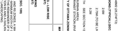
41 I III IV V VI VII VIII IX X Sub- Principal Minimum Minimum Maximum Minimum Minimum Minimum Minimum Zone Dwelling Lot Lot Area Building Front Corner Rear Interior Types Width (m2) Height (m) Yard Side Yard Side (m) Setback Yard Setback Yard (m) Setback (m) Setback (m) (m) Z Planned unit 18 1,400 as per varies 1 varies 1 development dwelling type Apartment dwelling, low rise, Stacked varies 12 varies 12 I Endnote number II Additional Zoning Provision 1 Despite the definitions of rear yard and interior side yard, buildings in a PUD must be located so that they are set back, (a) an amount equal to the minimum required rear yard setback for the dwelling type proposed, from a lot line where it abuts a rear yard on an abutting lot but need not exceed 7.5 metres, (b) an amount equal to the minimum required interior side yard setback for the dwelling type proposed, from a lot line where it abuts a side yard on an abutting lot for the first 18 metres back from the street and 25 percent of the lot depth for the remainder, to a maximum 7.5 metres, and (c) in the case of an abutting vacant lot, a minimum required interior side yard of 1.8 metres, and a minimum required rear yard setback based on the minimum rear yard setback applicable to JLR J.L. Richards & Associates Limited
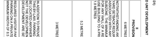
42 the dwelling type proposed to be located within the PUD adjacent to the rear lot line. 10 The minimum setback between the vehicular entrance to a private garage or carport and an existing or planned sidewalk is 6.2 m. No portion of a private garage or carport shall be located more than 2.5 m closer to a street lot line than the closer of: i) a building front wall or side wall, or ii) a covered porch or veranda that is at least 2.5 m wide. 12 Interior Side Yard Setback: For any part of a building located within 21 metres of a front lot line the minimum required interior side yard setback is as follows: (a) Where the building wall is equal to or less than 11 m in height: 1.5 m (b) Where the building wall is greater than 11 m in height: 3 m In all other circumstances the minimum required interior side yard setback is 6 m. Rear Yard Setback: The minimum required rear yard setback is 6 metres. Notwithstanding the foregoing, where the rear lot line abuts the interior side lot line of an abutting lot, the minimum required rear yard setback is equal to the minimum required interior side yard setback of the abutting lot along each point of the shared lot line.(by-law ) (By-law ) Section 131 of the Zoning By-law outlines the provisions for a Planned Unit Development. The standards for a Planned Unit Development are found in Table 131 as follows: I ZONING MECHANISM II PROVISION (1) Minimum width of private way 6 metres (2) Minimum setback for any wall of a residential use building to a private way Notwithstanding any front yard setback requirement associated with any zone or subzone, the minimum setback for any wall of a JLR J.L. Richards & Associates Limited
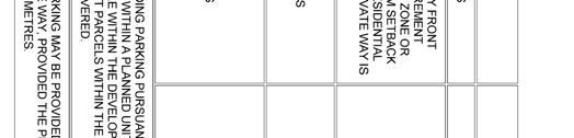
43 residential use building to a private way is 1.8 metres (3) Minimum setback for any garage or carport entrance from a private way (By-law ) 5.2 metres (4) Minimum separation area between buildings within a planned unit development (a) where the height of abutting buildings within the PUD is less than or equal to 14.5 metres (b) all other cases 1.2 metres 3 metres (5) Parking (a) In addition to providing parking pursuant to Section 100 of this by-law, parking within a planned unit development may be located anywhere within the development, whether or not the development parcels within the planned unit development are severed. (By-law ) (b) Required visitor parking may be provided as parallel parking on a private way, provided the private way has a minimum width of 8.5 metres. (By-law ) (6) Landscaping and Parking In the case of a planned unit development consisting of detached, linked-detached, semidetached, three-unit or townhouse dwellings, or any combination thereof, all lands located between the dwelling unit, the extension of the main wall of the dwelling unit, and the private way are to be landscaped with soft landscaping, other than the area used for a driveway leading to the dwelling unit s associated parking space, garage or carport have a driveway that is wider than the associated parking space, garage, or carport. Furthermore, the remaining area between the dwelling unit and the private way must be landscaped with soft landscaping, with the exception of a walkway of no more than 1.8m in width. (By-law ) (Subject to By-law ) JLR J.L. Richards & Associates Limited
44 The proposed Site Plan is in compliance with the zoning standards of the R4Z zone Section 131 and all other relevant General, Parking and Residential provisions. JLR J.L. Richards & Associates Limited
PLANNING RATIONALE FOR ZONING BY-LAW AMENDMENT MINTO COMMUNITIES INC. ARCADIA RESIDENTIAL STAGES 3 & 4 ARCADIA COMMERCIAL STAGE 2 CITY OF OTTAWA
 PLANNING RATIONALE FOR ZONING BY-LAW AMENDMENT MINTO COMMUNITIES INC. ARCADIA RESIDENTIAL STAGES 3 & 4 ARCADIA COMMERCIAL STAGE 2 CITY OF OTTAWA Prepared for: MINTO COMMUNITIES INC. 180 Kent Street, Suite
178 Carruthers Properties Inc.
 178 Carruthers Properties Inc. Planning Rationale for 178 Carruthers Avenue Site Plan Control Application June 2014 Table of Contents 1.0 Introduction 2.0 Overview of Subject Property 3.0 Current Zoning
RIVERSIDE SOUTH DEVELOPMENT PHASE 8 (980 Earl Armstrong Road) REVISED PLANNING RATIONALE FOR ZONING BY-LAW AMENDMENT (D# )
 REVISED PLANNING RATIONALE FOR ZONING BY-LAW AMENDMENT (D# )") RIVERSIDE SOUTH DEVELOPMENT PHASE 8 (980 Earl Armstrong Road) REVISED PLANNING RATIONALE FOR ZONING BY-LAW AMENDMENT (D#02-02-09-0060) July 2009 Revised August 2015 Prepared for: RIVERSIDE SOUTH DEVELOPMENT
RIVERSIDE SOUTH DEVELOPMENT PHASE 8 (980 Earl Armstrong Road) REVISED PLANNING RATIONALE FOR ZONING BY-LAW AMENDMENT (D#02-02-09-0060) July 2009 Revised August 2015 Prepared for: RIVERSIDE SOUTH DEVELOPMENT
THE CITY OF VAUGHAN BY-LAW BY-LAW NUMBER
 THE CITY OF VAUGHAN BY-LAW BY-LAW NUMBER 123-2013 A By-law to designate the whole of the City of Vaughan as a Site Plan Control Area, and to adopt site development guidelines and rules of procedure for
PORT WHITBY COMMUNITY
 PORT WHITBY COMMUNITY SECONDARY PLAN UPDATE COMMUNITY IMPROVEMENT PLAN URBAN DESIGN GUIDELINES September 2015 DRAFT PROPOSED AMENDMENT NUMBER # to the Whitby Official Plan PURPOSE: The intent of this Amendment
PLANNING JUSTIFICATION REPORT
 PLANNING JUSTIFICATION REPORT 55 DELHI STREET CITY OF GUELPH PREPARED FOR: VESTERRA PROPERTY MANAGEMENT PREPARED BY: LABRECHE PATTERSON & ASSOCIATES INC. SCOTT PATTERSON, BA, CPT, MCIP, RPP PRINCIPAL,
KANATA CENTRUM 255 KANATA AVENUE OFFICIAL PLAN AMENDMENT ZONING BY-LAW AMENDMENT
 KANATA CENTRUM 255 KANATA AVENUE OFFICIAL PLAN AMENDMENT ZONING BY-LAW AMENDMENT JUNE 2015 PREPARED BY: FOTENN Consultants Inc. 223 Mcleod Street Ottawa, ON K2P OZ8 (613) 730-5709 PREPARED FOR: Kanata
FORMER CANADIAN FORCES BASE (CFB) ROCKCLIFFE SECONDARY PLAN. Official Plan Amendment XX to the Official Plan for the City of Ottawa
 ROCKCLIFFE SECONDARY PLAN. Official Plan Amendment XX to the Official Plan for the City of Ottawa") FORMER CANADIAN FORCES BASE (CFB) ROCKCLIFFE SECONDARY PLAN Official Plan Amendment XX to the Official Plan for the City of Ottawa 1 INDEX THE STATEMENT OF COMPONENTS PART A THE PREAMBLE PAGE Purpose...
FORMER CANADIAN FORCES BASE (CFB) ROCKCLIFFE SECONDARY PLAN Official Plan Amendment XX to the Official Plan for the City of Ottawa 1 INDEX THE STATEMENT OF COMPONENTS PART A THE PREAMBLE PAGE Purpose...
URBAN DESIGN BRIEF URBAN DESIGN BRIEF 721 FRANKLIN BLVD, CAMBRIDGE August 2018
 URBAN DESIGN BRIEF URBAN DESIGN BRIEF 721 FRANKLIN BLVD, CAMBRIDGE August 2018 DESIGN BRIEF CONTENTS PART A 1.0 INTRODUCTION 2.0 DESCRIPTION & ANALYSIS OF SITE CONTEXT 3.0 DESIGN CONSTRAINTS AND OPPORTUNITIES
URBAN DESIGN BRIEF. 2136&2148 Trafalgar Road. Town of Oakville
 URBAN DESIGN BRIEF 2136&2148 Trafalgar Road Town of Oakville Prepared By: METROPOLITAN CONSULTING INC For 2500674 Ontario Inc November 2016 TABLE OF CONTENTS Page No. 1.0 Introduction/Description of Subject
2136 & 2148 Trafalgar Road Town of Oakville Region of Halton
 PLANNING JUSTIFICATION REPORT 2136 & 2148 Trafalgar Road Town of Oakville Region of Halton Zoning By-Law Amendment Application 2500674 Ontario Inc. November 2016 Table of Contents Page 1.0 Location/Summary
Design Brief and Planning Rationale. for Site Plan Control Application. Harmony Subdivision, Stage 1, Block 104
 Design Brief and Planning Rationale for Site Plan Control Application Harmony Subdivision, Stage 1, Block 104 4025 Strandherd Drive, Minto Communities Inc. Prepared By: NOVATECH Suite 200, 240 Michael
Mark-up of the effect of the proposed Bronte Village Growth Area OPA No.18 on the text of section 24, Bronte Village, of the Livable Oakville Plan
 Mark-up of the effect of the proposed Bronte Village Growth Area OPA No.18 on the text of section 24, Bronte Village, of the Livable Oakville Plan Notes: This document is provided for information purposes
URBAN DESIGN BRIEF Gordon Street City of Guelph. Prepared on behalf of Ontario Inc. March 25, Project No. 1507
 URBAN DESIGN BRIEF 1131 Gordon Street City of Guelph Prepared on behalf of 1876698 Ontario Inc. March 25, 2016 Project No. 1507 423 Woolwich Street, Suite 201, Guelph, Ontario, N1H 3X3 Phone (519) 836-7526
5.1 Site Plan Guidelines
 5. Community Core Guidelines Development of the Community Core will take place by plan of subdivision and site plan approval. It will occur in a phased manner that will reflect the timing of residential
DRAFT Northeast Quadrant of Kipling Avenue and Highway 7 DRAFT AUGUST 29, Goals Land Use. The goals of this Plan are to:
 AUGUST 29, 2017 12.15 Northeast Quadrant of Kipling Avenue and Highway 7 12.15.1 Goals 12.15.2 Land Use The goals of this Plan are to: 12.15.2.1 General Provisions: a) Ensure the development of a compact
[PLANNING RATIONALE] For Site Plan Control and Lifting of Holding Zone By-Law 101 Champagne Avenue. May 23, 2014
![[PLANNING RATIONALE] For Site Plan Control and Lifting of Holding Zone By-Law 101 Champagne Avenue. May 23, 2014](/thumbs/75/71599615.jpg "[PLANNING RATIONALE] For Site Plan Control and Lifting of Holding Zone By-Law 101 Champagne Avenue. May 23, 2014") [PLANNING RATIONALE] For Site Plan Control and Lifting of Holding Zone By-Law 101 Champagne Avenue May 23, 2014 Contents 1.0 Introduction... 2 2.0 Site Context... 2 2.1 Adjacent Uses... 2 Figure 1: Site
[PLANNING RATIONALE] For Site Plan Control and Lifting of Holding Zone By-Law 101 Champagne Avenue May 23, 2014 Contents 1.0 Introduction... 2 2.0 Site Context... 2 2.1 Adjacent Uses... 2 Figure 1: Site
Urban Design Brief December 23, 2015 Southside Construction Group Official Plan & Zoning By-Law Amendment
 Urban Design Brief Proposed Official Plan & Zoning By-Law Amendment 3244, 3263 and 3274 Wonderland Road South Southside Group December 23, 2015 TABLE OF CONTENTS Page No. INTRODUCTION... 1 SECTION 1 LAND
599 Kennedy Road - Official Plan Amendment and Zoning Amendment Application - Preliminary Report
 STAFF REPORT ACTION REQUIRED 599 Kennedy Road - Official Plan Amendment and Zoning Amendment Application - Preliminary Report Date: March 7, 2017 To: From: Wards: Reference Number: Scarborough Community
Commercial Development Proposal Tenth Line Road. Planning Rationale Report. Minto Developments Inc.
 Commercial Development Proposal 2168 Tenth Line Road Report September 2015 Prepared for Minto Developments Inc. Paquette Planning Associates Ltd. 56 Hutchison Avenue Ottawa, Ontario K1Y 4A3 PH: 613-722-7217
DAVENPORT VILLAGE SECONDARY PLAN
 27 DAVENPORT VILLAGE SECONDARY PLAN 27. DAVENPORT VILLAGE SECONDARY PLAN 1. VISION FOR THE DAVENPORT VILLAGE SECONDARY PLAN Davenport Village, municipally known as 830, 940, 980 and 1100 Lansdowne Avenue,
Urban Design Brief Proposed Residential Development 5219 Upper Middle Road City of Burlington
 Urban Design Brief Proposed Residential Development 5219 Upper Middle Road City of Burlington Prepared by Weston Consulting Prepared for BLOOMFIELD DEVELOPMENT INC. Date: March 2017 Table of Contents 1.
Planning Rationale Fernbank Road, Ottawa. Major Zoning By-law Amendment and Site Plan Control Application Ontario Inc.
 Planning Rationale Major Zoning By-law Amendment and Site Plan Control Application 5264 Fernbank Road, Ottawa 1872089 Ontario Inc. March 2014 Planning Rationale Major Zoning By-law Amendment and Site Plan
CONTENTS 8.0 LAND USE 8.1 GENERAL LAND USE 8.2 RESIDENTIAL 8.3 MIXED USE 8.4 COMMERCIAL 8.5 EMPLOYMENT LANDS
 8-2 Land Use 8.0 LAND USE CONTENTS 8.1 GENERAL LAND USE 8.1.1 Uses provided for in all Land Use Designations 8.1.2 Uses prohibited in Hazardous Lands, Hazardous Sites and Special Policy Areas 8.1.3 Uses
PLANNING RATIONALE FOR THE PROPOSED RIVERSIDE SOUTH ELEMENTARY SCHOOL 715 BRIAN GOOD AVENUE, OTTAWA, ON
 PLANNING RATIONALE FOR THE PROPOSED RIVERSIDE SOUTH ELEMENTARY SCHOOL 715 BRIAN GOOD AVENUE, OTTAWA, ON Conseil des écoles publiques de l'est de l'ontario (CEPEO) French Public School Board TABLE OF CONTENTS
10 COPE DRIVE. May 08, 2018 Planning Rationale and Design Brief. Site Plan Control
 10 COPE DRIVE May 08, 2018 Planning Rationale and Design Brief Site Plan Control Prepared for: Taggart Realty Management 225 Metcalfe Street, Suite 708 Ottawa, ON K2P 1P9 taggart.ca Prepared by: Fotenn
141 GEORGE STREET PLANNING RATIONALE
 141 GEORGE STREET PLANNING RATIONALE MINOR ZONING BY-LAW AMENDMENT NOVEMBER 2, 2016 PLANNING RATIONALE 223 McLeod Street Ottawa, ON K2P 0Z8 613.730.5709 fotenn.com INTRODUCTION FOTENN Consultants is acting
and services The protection and conservation of environmentally significant and sensitive natural heritage features and functions.
 6. Land Use 6.0 Preamble A healthy and livable city is one in which people can enjoy a vibrant economy and a sustainable healthy environment in safe, caring and diverse neighbourhoods. In order to ensure
The West Vaughan Employment Area Secondary Plan Policies
 Part 2: The West Vaughan Employment Area Secondary Plan Policies 2.1 General Policies It is the policy of Council: 2.1.1. That the West Vaughan Employment Area (the WVEA), identified on Schedule 1, will
5.0 Community Design Plan
 5.0 Community Design Plan The Community Design Plan for the Mer Bleue area is a composite of three plans: Land Use Plan Transportation Plan Municipal Servicing Plan Read together, these Plans and associated
URBAN DESIGN BRIEF 181 Burloak Drive, Oakville
 URBAN DESIGN BRIEF 181 Burloak Drive, Oakville February 2017 Our File: 1730B 230-7050 WESTON ROAD / WOODBRIDGE / ONTARIO / L4L 8G7 / T: 905 761 5588/ F: 905 761 5589/WWW.MHBCPLAN.COM TABLE OF CONTENTS
Uptown Rideau Street Secondary Plan [Amendment #166, January 12, 2016]
![Uptown Rideau Street Secondary Plan [Amendment #166, January 12, 2016]](/thumbs/76/73760497.jpg "Uptown Rideau Street Secondary Plan [Amendment #166, January 12, 2016]") [Amendment #166, January 12, 2016] The policies of this Secondary Plan are in effect, save and except for the property at 560 Rideau Street, for which there remains a site specific appeal to this Secondary
[Amendment #166, January 12, 2016] The policies of this Secondary Plan are in effect, save and except for the property at 560 Rideau Street, for which there remains a site specific appeal to this Secondary
TABLE OF CONTENTS 1.0 INTRODUCTION... 3
 TABLE OF CONTENTS 1.0 INTRODUCTION... 3 1.1. BACKGROUND... 3 1.2. THE PROPOSAL... 5 2.0 EXISTING POLICY FRAMEWORK... 5 2.1. PROVINCIAL POLICY STATEMENT (PPS)... 5 2.2. CITY OF LONDON OFFICIAL PLAN (OP)...
6.0 Land Use Policies for Rural Settlements. 6.1 Rural Settlement Strategy
 6.0 Land Use Policies for Rural Settlements 6.1 Rural Settlement Strategy INTRODUCTION AMENDMENT NO. 131 PURPOSE Designated rural settlements comprise Rural Clusters, Villages and Serviced Villages as
4780 Eglinton Avenue West - Zoning By-law Amendment and Draft Plan of Subdivision Applications - Preliminary Report
 STAFF REPORT ACTION REQUIRED 4780 Eglinton Avenue West - Zoning By-law Amendment and Draft Plan of Subdivision Applications - Preliminary Report Date: May 29, 2014 To: From: Wards: Reference Number: Etobicoke
11.4 Highway 400 North Employment Lands Secondary Plan APPROVED BY THE ONTARIO MUNICIPAL BOARD ON NOVEMBER 21, 2011
 11.4 Highway 400 North Employment Lands Secondary Plan APPROVED BY THE ONTARIO MUNICIPAL BOARD ON NOVEMBER 21, 2011 11.4.1 General 11.4.1.1. as approved by the Ontario Municipal Board on November 21, 2011,
Re: 1110 Fisher Avenue Proposed Residential Development Revised Proposal File D PLANNING RATIONALE ADDENDUM
 October 23, 2014 Prestige Design & Construction 50 Camelot Drive Ottawa, ON K2G 5X8 Attention: Mr. Enzo DiChiara Dear Mr. DiChiara Re: 1110 Fisher Avenue Proposed Residential Development Revised Proposal
Bank Street Secondary Plan
 1.1 Introduction The is a guide to the long term design and development of the portion of Bank Street between Riverside Drive and Ledbury Park, and provides direction on land use, built form, design, parking,
PLANNING RATIONALE 3843 INNES ROAD, ORLEANS 78 UNITS CONDOMINIUM PROJECT MELKART DEVELOPMENTS Inc.
 78 UNITS CONDOMINIUM PROJECT MELKART DEVELOPMENTS Inc. 2 PLANNING RATIONALE 78 UNITS CONDOMINIUM PROJECT Proposed at 3843 Innes Road Orleans, Ontario Report Prepared for: Melkart Developments Inc. 3497
Clairtrell Area Context Plan
 Clairtrell Area Context Plan March 2005 Urban Development Services City Planning Contents 1. Introduction... 4 2. Development Structure... 6 2.1 Streets... 7 2.1.1 Sheppard Avenue and Bayview Avenue...
OFFICE CONSOLIDATION SECONDARY PLAN AREA 22 THE BRAMALEA SOUTH INDUSTRIAL SECONDARY PLAN
 OFFICE CONSOLIDATION SECONDARY PLAN AREA 22 THE BRAMALEA SOUTH INDUSTRIAL SECONDARY PLAN November 2010 EXPLANATORY NOTES (Secondary Plan Area 22) General (pertaining to all secondary plan office consolidations)
K. SMART ASSOCIATES LIMITED
 Planning Justification Report Zoning By-Law Amendment 185 King Street North Waterloo, Ontario April 7th, 2017 Project Reference Number 16-245 K. SMART ASSOCIATES LIMITED CONSULTING ENGINEERS AND PLANNERS
Greystone Village Main Street. Terraces at Greystone. City of Ottawa. Planning Rationale
 Greystone Village - 175 Main Street Terraces at Greystone City of Ottawa Planning Rationale Prepared By: NOVATECH Suite 200, 240 Michael Cowpland Drive Ottawa, Ontario K2M 1P6 August / 7 / 2015 Novatech
I615. Westgate Precinct
 I615. Westgate Precinct I615.1. Precinct Description The Westgate Precinct is located approximately 18km west of the Auckland city centre. There are seven Sub-precincts in the Westgate Precinct: Sub-precinct
Urban Design Brief. Watson Parkway North & Watson Road North Guelph, Ontario. Prepared by Coletara Development
 Urban Design Brief Watson Parkway North & Watson Road North Guelph, Ontario Prepared by Coletara Development December, 2013 Urban Design Brief, Coletara Development 1 Introduction This Urban Design Brief
Figure 1- Site Plan Concept
 Figure 1- Site Plan Concept Parking will be provided underground on three levels at rate of 1.0 space/ unit; this rate includes all visitors parking. MMM Group has prepared a parking assessment (April,
ONTARIO MUNICIPAL BOARD
 PL 120483 ONTARIO MUNICIPAL BOARD Applicant/Appellant: 2124123 Ontario Limited Subject: OPA, Rezoning and Draft Plan of Subdivision Municipal Address: 3940 Highway 7 East Municipality: City of Markham
Urban Design Manual PLANNING AROUND RAPID TRANSIT STATIONS (PARTS) Introduction. Station Study Areas
 Introduction. Station Study Areas") 111111 PLANNING AROUND RAPID TRANSIT STATIONS (PARTS) Introduction The ION rapid transit system will link Waterloo, Kitchener and Cambridge through a central transit corridor (CTC). There are a number
111111 PLANNING AROUND RAPID TRANSIT STATIONS (PARTS) Introduction The ION rapid transit system will link Waterloo, Kitchener and Cambridge through a central transit corridor (CTC). There are a number
776 and 784 St. Laurent Boulevard City of Ottawa
 Engineering Land / Site Development Municipal Infrastructure Environmental / Water Resources Traffic / Transportation Structural Recreational 776 and 784 St. Laurent Boulevard City of Ottawa Planning Rationale
20 & 30 Frank Nighbor Place
 Engineering Land / Site Development Municipal Infrastructure Environmental / Water Resources Traffic / Transportation Structural Recreational Planning Land / Site Development Planning Application Management
East Bayshore Road Neighbourhood
 East Bayshore Road Neighbourhood Northridge Property Management Urban Design Brief 3195 East Bayshore Road City of Owen Sound January 2016 East Bayshore Road Neighbourhood Northridge Property Management
Report Regarding Site Plan Control for 55 Wellspring Way (File No. SP-06-16)
") Report Regarding Site Plan Control for 55 Wellspring Way (File No. SP-06-16) Executive Summary: The purpose of this report is to provide Council with information regarding site plan control under Section
Report Regarding Site Plan Control for 55 Wellspring Way (File No. SP-06-16) Executive Summary: The purpose of this report is to provide Council with information regarding site plan control under Section
1120 Haist Street - Pelham Arena Community Co-Design Recommendation Report Haist Street - Pelham Arena Community Co-Design Recommendation Report
 1120 Haist Street - Pelham Arena Community Co-Design Executive Summary: In May, 2017 the Town retained the services of The Planning Partnership to undertake a community design charrette process to determine
URBAN DESIGN BRIEF REPORT
 URBAN DESIGN BRIEF REPORT PREPARED FOR 2568401 ONTARIO INC NEW GASBAR, CONVENIENCE STORE & CARWASH DEVELOPMENT @ 1509 FANSHAWE PARK ROAD WEST LONDON, ONTARIO GAMA ENGINEERING INC. PROJECT NUMBER 1669 PREPARED
The lands identified as Residential Areas on Schedule A1, Urban Structure, represent the areas that provide for stable residential communities.
 Livable Oakville Part D: Land Use Designations and Policies 11. RESIDENTIAL 11.1 General The lands identified as Residential Areas on Schedule A1, Urban Structure, represent the areas that provide for
A Growing Community Rural Settlement Areas
 Town of Huntsville Official Plan Review - POLICY BACKGROUND PAPER A Growing Community Rural Settlement Areas BACKGROUND: In addition to the fully municipally-serviced Urban Settlement Area and the Hidden
MEADOWGLEN DR. ORLEANS. Zoning By-Law Amendment Application November 2012
 5911 MEADOWGLEN DR. ORLEANS Zoning By-Law Amendment Application November 2012 Prepared by: 223 McLeod Street Ottawa, ON K2P 0Z8 T: 613.730.5709 ext.238 F: 613.730.1136 Prepared for: 371A Richmond Road,
AGINCOURT SECONDARY PLAN
 1 AGINCOURT SECONDARY PLAN 1. AGINCOURT SECONDARY PLAN The following policies and principles apply to the area herein referred to as Agincourt, as outlined on Map 1-1. 1. GENERAL POLICIES 1.1 This Secondary
YONGE STEELES CORRIDOR SECONDARY PLAN. Young + Wright / IBI Group Architects Dillon Consulting Ltd. GHK International (Canada) Ltd.
 Ltd.") PART A: PREAMBLE 1.0 PURPOSE The purpose of this Secondary Plan is to provide a development framework for intensification of the Yonge/ Steeles corridor including the north side of Steeles Avenue West
PART A: PREAMBLE 1.0 PURPOSE The purpose of this Secondary Plan is to provide a development framework for intensification of the Yonge/ Steeles corridor including the north side of Steeles Avenue West
Bressa Developments Limited. Planning Justification Report. Revised Draft Plan of Subdivision and Zoning By-Law Amendment
 Bressa Developments Limited Revised Draft Plan of Subdivision and Zoning By-Law Amendment Planning Justification Report Part of Lots 7 & 8 Concession 1, North of Dundas Street Town of Oakville September,
Trafalgar Road Corridor Planning Study Open House
 Trafalgar Road Corridor Planning Study Open House June 24, 2013 6:30-8:30 p.m. Oakville & Trafalgar Rooms Overview The Livable Oakville Plan identifies the lands along Trafalgar Road, between the QEW and
City of Vaughan Urban Design Guidelines for Infill Development in Established Low-Rise Residential Neighbourhoods
 City of Vaughan Urban Design Guidelines for Infill Development in Established Low-Rise Residential Neighbourhoods DRAFT - September 2016 Contents 1. Introduction 1 2. Policy Context 3 3. Characteristics
Urban Design Guidelines Townhouse and Apartment Built Form
 Urban Design Guidelines Townhouse and Apartment Built Form Town of Wasaga Beach Table of Contents 1. Introduction 1.1. Purpose 1.2. Urban Design Principles 1.3. Application of Guidelines 2. Site Design,
MOMENTUM. Design Brief. Site Plan Control and Minor Variance Applications. 59 Russell Avenue
 MOMENTUM PLANNING AND COMMUNICATIONS Design Brief Site Plan Control and Minor Variance Applications 59 Russell Avenue December 2014 Revised February 2015 Prepared by: Dennis Jacobs MCIP, RPP Index 1. Introduction
Draft Urban Hamilton Official Plan. Amendment No. XX
 1 of 75 The following text, together with: Draft Appendix A Appendix B Volume 1, Schedule E-1 Urban Land Use Designations Appendix C Volume 1, Appendix A Parks Classification Map Appendix D Volume 1, Appendix
Welcome. Walk Around. Talk to Us. Write Down Your Comments
 Welcome This is an information meeting introducing the applications for proposed redevelopment of the Yorkdale Shopping Centre site at 3401 Dufferin Street and 1 Yorkdale Road over the next 20+ years,
ROAD CLOSURE AND LAND USE AMENDMENT SILVER SPRINGS (WARD 1) NORTHEAST OF NOSEHILL DRIVE NW AND SILVER SPRINGS ROAD NW BYLAWS 2C2018 AND 29D2018
 NORTHEAST OF NOSEHILL DRIVE NW AND SILVER SPRINGS ROAD NW BYLAWS 2C2018 AND 29D2018") Page 1 of 19 EXECUTIVE SUMMARY This application proposes redesignating two parcels in the community of Silver Springs from Special Purpose Future Urban Development (S-FUD) District and undesignated road
Page 1 of 19 EXECUTIVE SUMMARY This application proposes redesignating two parcels in the community of Silver Springs from Special Purpose Future Urban Development (S-FUD) District and undesignated road
420 FANSHAWE PARK ROAD EAST London, ON
 420 FANSHAWE PARK ROAD EAST London, ON URBAN DESIGN BRIEF, CHARACTER STATEMENT & COMPATIBILITY REPORT April 2016 Prepared by MHBC Planning 630 COLBORNE STREET SUITE 202 LONDON, ON N6B 2V2 TABLE OF CONTENTS
Complete Neighbourhood Guidelines Review Tool
 Complete Neighbourhood Guidelines Review Tool Prepared By: City of Regina Planning Department October 2014 Page 1 of 14 Community Development Review Checklist for Secondary Plans and Concept Plans The
Attachment 1 TOWN OF NEW TECUMSETH. Manual for the Preparation of an Urban Design Report
 Attachment 1 TOWN OF NEW TECUMSETH Manual for the Preparation of an Urban Design Report July 2010 TABLE OF CONTENTS Background, Policy Framework and the Preparation of Urban Design Reports 1. Introduction
13 THORNHILL YONGE STREET STUDY IMPLEMENTATION CITY OF VAUGHAN OPA 669 AND TOWN OF MARKHAM OPA 154
 13 THORNHILL YONGE STREET STUDY IMPLEMENTATION CITY OF VAUGHAN OPA 669 AND TOWN OF MARKHAM OPA 154 The Planning and Economic Development Committee recommends the adoption of the recommendations contained
Planning Rationale in Support of an Application for Zoning By-Law Amendment. 4495, 4499, 4509 & 4515 Innes Road City of Ottawa
 Planning Rationale in Support of an Application for Zoning By-Law Amendment 4495, 4499, 4509 & 4515 Innes Road City of Ottawa Prepared by: Holzman Consultants Inc. Land Development Consultants March 26,
Official Plan Review
 Official Plan Review Summary Report - The Built Environment August 2014 Part 1: Introduction Planning for a healthy, prosperous and sustainable community is an important goal for our municipality. From
SCHEDULE 'A' TO BY-LAW as Amended by AMENDMENT NO. 90 TO THE WHITBY OFFICIAL PLAN
 SCHEDULE 'A' TO BY-LAW 6413-10 as Amended by 6553-11 AMENDMENT NO. 90 TO THE WHITBY OFFICIAL PLAN SECTION A: GROWTH PLAN CONFORMITY PURPOSE: LOCATION: BASIS: The purpose of this Amendment is to: conform
Regency Developments. Urban Design Brief. Holyrood DC2 Rezoning
 Regency Developments Urban Design Brief Holyrood DC2 Rezoning Stantec Consulting Ltd. 7-31-2017 1. Overview Regency Developments intends to rezone the lands located at 8510 and 8511 93 Avenue, within the
PART III LAND USE POLICIES URBAN PLANNING AREA
 To be read with other parts of the Plan 1.0 INTRODUCTION *D9 This part of the Plan presents the principles, objectives and policies for the land use designations identified on the Settlement Pattern and
THE CORPORATION OF THE TOWN OF OAKVILLE BY-LAW NUMBER
 THE CORPORATION OF THE TOWN OF OAKVILLE BY-LAW NUMBER 2017-120 A by-law to adopt an amendment to the Livable Oakville Plan, Official Plan Amendment Number 20 (Downtown Oakville Growth Area) WHEREAS the
11.4 Highway 400 North Employment Lands Secondary Plan
 11.4 Highway 400 North Employment Lands Secondary Plan APPROVED BY THE ONTARIO MUNICIPAL BOARD ON NOVEMBER 21, 2011 11.4.1 General 11.4.1.1. The following policies and Schedules A - I form Official Plan
Chapter PEDESTRIAN COMMERCIAL (PC) ZONING DISTRICT
 ZONING DISTRICT") Chapter 11-17 PEDESTRIAN COMMERCIAL (PC) ZONING DISTRICT Sections: 11-17-01 GENERAL PURPOSE 11-17-02 PERMITTED BUILDING TYPES 11-17-03 USES PERMITTED WITH DESIGN REVIEW 11-17-04 USES PERMITTED BY CONDITIONAL
Chapter 11-17 PEDESTRIAN COMMERCIAL (PC) ZONING DISTRICT Sections: 11-17-01 GENERAL PURPOSE 11-17-02 PERMITTED BUILDING TYPES 11-17-03 USES PERMITTED WITH DESIGN REVIEW 11-17-04 USES PERMITTED BY CONDITIONAL
*** DRAFT 2 FOR PUBLIC REVIEW ***
 6.7 The area is generally bounded by the Red Hill Valley Parkway to the west, Lake Avenue to the east, the Queen Elizabeth Way (QEW) to the north, and by the properties just south of Queenston Road to
770 BRONSON AVENUE. Zoning By-law Amendment and Site Plan Control
 770 BRONSON AVENUE Zoning By-law Amendment and Site Plan Control Revised Planning Rationale + Design Brief August 2016 REVISED PLANNING RATIONALE 223 McLeod Street Ottawa, ON K2P 0Z8 613.730.5709 fotenn.com
PLANNING RATIONALE FOR 1127, 1128 MILL STREET AND 1125 CLAPP LANE CITY OF OTTAWA
 PLANNING RATIONALE FOR 1127, 1128 MILL STREET AND 1125 CLAPP LANE CITY OF OTTAWA Prepared by: Realty Initiatives and Development On behalf of the Manotick Mill Community Lands Development Corporation March
Bylaw A Bylaw to amend Bylaw 12800, as amended, The Edmonton Zoning Bylaw Amendment No. 2239
 Bylaw 17672 A Bylaw to amend Bylaw 12800, as amended, The Edmonton Zoning Bylaw Amendment No. 2239 WHEREAS City Council at its meeting of February 22, 2001, gave third reading to Bylaw 12800, as amended;
From: Director, Community Planning, Etobicoke York District
 STAFF REPORT ACTION REQUIRED 4208, 4210 and 4214 Dundas Street West - Official Plan Amendment and Zoning By-law Amendment Application - Preliminary Report Date: July 22, 2014 To: Etobicoke York Community
Highland Village Green Design Guidelines
 Highland Village Green Design Guidelines Publishing Information Title Highland Village Green Design Guidelins Author The City of Calgary Status DRAFT - Proposed document subject to changes Additional Copies
Planning & Development. Background. Subject Lands
 Planning & Development APPLICATION BRIEFING Prepared For: Planning Advisory Committee Submitted by: Jason Fox, Director of Planning & Development Date: Subject: Development Agreement Application by Brentwood
Foster Creek West Clarington, Ontario PLANNING JUSTIFICATION REPORT
 Foster Creek West Clarington, Ontario PLANNING JUSTIFICATION REPORT Official Plan Amendment Zoning By-law Amendment Neighbourhood Design Plan Amendment Draft Plan of Subdivision File No. 112092 February
Duplex Design Guidelines
 Duplex Design Guidelines Adopted by Council May 29, 2006 Prepared By: Table of Contents 1.0 Application and Intent 1 2.0 Areas of Application 2 3.0 Design Principles 3 4.0 Design Guidelines 4 4.1 Site
OP Council Resolution June 16, Planning and Development Services
 OP-08-01 Council Resolution June 16, 2008 Planning and Development Services Kingsgate Landing Outline Plan Table of Contents 1.0 Introduction 1 1.1 Purpose of Plan 1 1.2 Plan Area Location 1 1.3 Ownership
Ensure that development within the Arrowtown Urban Growth Boundary provides:
 URBAN DEVELOPMENT 4 4.2.5.2 Ensure that development within the Arrowtown Urban Growth Boundary provides: an urban form that is sympathetic to the character of Arrowtown, including its scale, density, layout
Revised Planning Rationale in Support of an Application for Site Plan Control Leitrim Road City of Ottawa
 Revised Planning Rationale in Support of an Application for Site Plan Control 2644-2670 Leitrim Road City of Ottawa Prepared by: Holzman Consultants Inc. Land Development Consultants October 24, 2017 TABLE
Urban Design Brief to 1557 Gordon Street & 34 Lowes Road West
 Urban Design Brief 1533 to 1557 Gordon Street & 34 Lowes Road West Reid s Heritage Homes Ltd. & 883928 Ontario Ltd. and RHH Property Management Ltd. City of Guelph Zoning By-law Amendment November 2017
Public Storage Self-storage Facility (Warehouse)
") Public Storage Self-storage Facility (Warehouse) 3545 St. Joseph Boulevard Planning Rationale PREPARED FOR: Maple Reinders Constructors Ltd. 2660 Argentia Road Mississauga, Ontario L5N 5V4 PREPARED BY:
Public Storage Self-storage Facility (Warehouse) 3545 St. Joseph Boulevard Planning Rationale PREPARED FOR: Maple Reinders Constructors Ltd. 2660 Argentia Road Mississauga, Ontario L5N 5V4 PREPARED BY:
Bayview Avenue Official Plan Amendment, Zoning Amendment and Site Plan Control Applications Request for Direction Report
 STAFF REPORT ACTION REQUIRED 2425 2427 Bayview Avenue Official Plan Amendment, Zoning Amendment and Site Plan Control Applications Request for Direction Report Date: May 28, 2015 To: From: Wards: Reference
KEY MAP DEVELOPMENT PERMIT AREA MAP. Sunnymede North Sub-Area Plan
 Richmond Official Community Plan BROADMOOR AREA SUNNYMEDE NORTH SUB-AREA PLAN Bylaw 7100 Schedule 2.6C SUNNYMEDE NORTH SUB-AREA PLAN SUNNYMEDE NORTH SUB-AREA PLAN SUNNYMEDE NORTH SUB-AREA PLAN KEY MAP
Dufferin Street and Centre Street Area Specific Policies
 12.XX 12.XX.1 12.XX.1.1. 12.XX.2. 12.XX.2.1. 12.XX.2.2 Dufferin Street and Centre Street Area Specific Policies Goals The goal of this Plan is to provide the necessary land use and development policies
OFFICE CONSOLIDATION CHAPTER 47 HIGHWAY 427 INDUSTRIAL SECONDARY PLAN
 OFFICE CONSOLIDATION CHAPTER 47 HIGHWAY 427 INDUSTRIAL SECONDARY PLAN NOTE: This Secondary Plan is partially in effect. Highlighted sections are under appeal. August 2017 1 EXPLANATORY NOTE Office Consolidation
Policies and Code Intent Sections Related to Town Center
 Policies and Code Intent Sections Related to Town Center The Town Center Vision is scattered throughout the Comprehensive Plan, development code and the 1994 Town Center Plan. What follows are sections
1296 Kennedy Road - Zoning Amendment Application - Preliminary Report
 STAFF REPORT ACTION REQUIRED 1296 Kennedy Road - Zoning Amendment Application - Preliminary Report Date: January 15, 2016 To: From: Wards: Reference Number: Scarborough Community Council Acting Director,
ARTICLE 6: Special and Planned Development Districts
 ARTICLE 6: Special and Planned Development Districts 6-10 Traditional Neighborhood Development (TND) District 6-10.10 Purpose and Intent The Traditional Neighborhood Development (TND) District provides