South Davis County COMMUNITY SPOTLIGHT
|
|
|
- Justina Harris
- 5 years ago
- Views:
Transcription


1 South Davis County COMMUNITY SPOTLIGHT
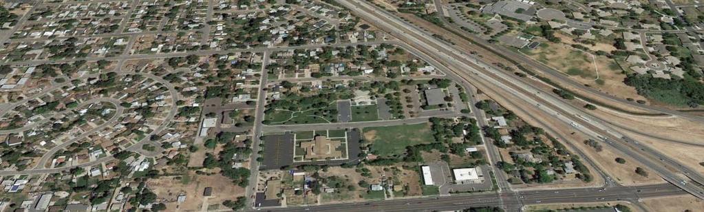
2 Davis/SLC Community Connector Bus Rapid Transit line connecting SLC & Davis County RTP Phase 1 Project Generate 3,100 average weekday riders Relieve congestion on I-15 improve air quality

3 Davis/SLC Community Connector LEGEND: Bus Rapid Transit Enhanced Bus Bike/Ped Stations

4 BRT Corridor Planning Project Elements: Corridor-wide land use plan Form Based Code Anticipated project deliverables: Implementable policies Provide travel choices Walkable areas near future transit stations

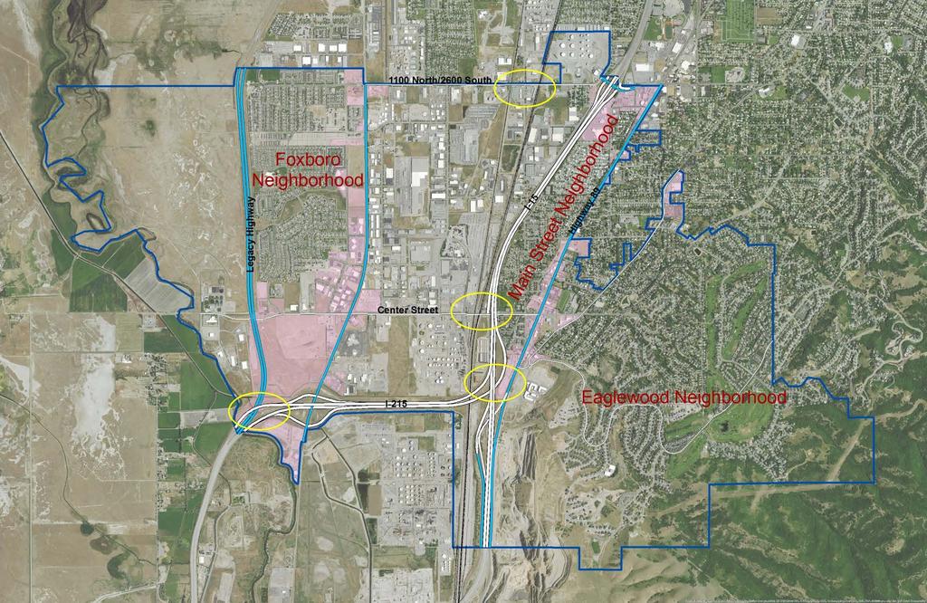
5 Bountiful Downtown Corridor City Campus Renaissance Town Center


6 Renaissance Town Center Renaissance Town Center Acres - 430,000+ sq.ft. of development - Multiple story flex - Office - Medical - Residential - Commercial All linked to Downtown Bountiful, North Salt Lake, and SLC by BRT


7 City Campus City Campus (Current City Hall Area) Acres Units Residential - 20,000 acres commercial/office Surrounded by Library, Senior Center, District Court Grocery within walking distance
8


9 NORTH SALT LAKE CHALLENGES Highway 89 -vacant, dilapidated properties -no landscaping -inadequate circulation/parking -poor pedestrian mobility -unattractive entries/intersections -Poor access to I-15 and I-215 Redwood Road -very unattractive corridor -retail buildings in industrial zones -industrial/residential mixed uses -very low walkability-100% auto-oriented -difficult interchange at I-215


 within the Town Center and")
10 NORTH SALT LAKE CHALLENGES -East/West connectivity disrupted by daily and constant rail stops -Infrequent bus service on Highway 89 low ridership -Low opportunity for biking and walking (last mile traveled) within the Town Center and Highway 89 corridor

11 OWN CENTER MASTER PLAN City s adopted goals and objectives: - Encourage intensity of activity in the Town Center. - Improve the appearance and enhance the safety of the Town Center and Highway 89 Corridor. - The transformation of Hatch Park into a community gathering place. - The inclusion of mixed-uses throughout the area, including dining and entertainment activities. - The development of additional public open spaces, including pedestrian corridors and plazas. - A Form-Base Code should be established for the Town Center.

12 Open Space, Trail, Bike Path and Pedestrian Mobility Plan in the Town Center Trails connect from the Bonneville Shoreline Trail west to the Legacy Nature Preserve and Jordan River and Legacy Parkway Trail systems. Connections also to the CBD for biking commuters. Hatch Park expansion a central focus of the Town Center.


13 URBAN DESIGN SOLUTIONS Highway 89 Center Street
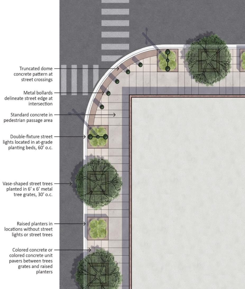
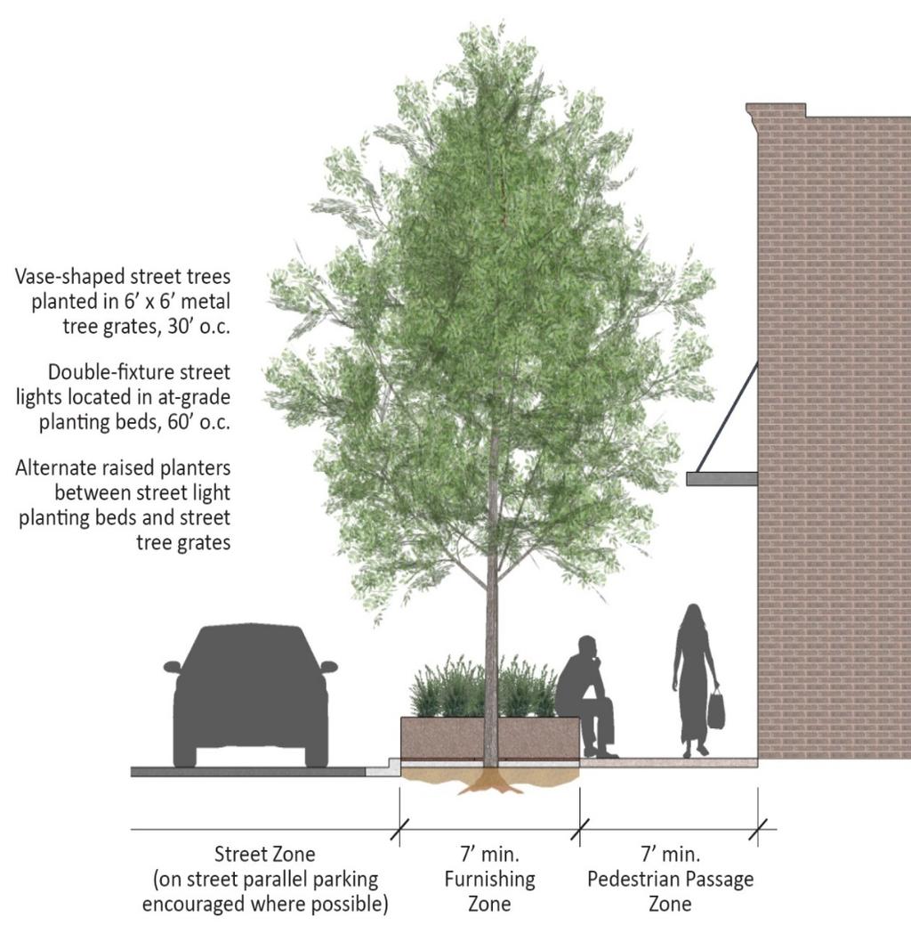
14 NEW STREETSCAPE STANDARDS


15 POTENTIAL STREETSCAPE EXAMPLES Example of on-street parallel and angled parking integrated into mixed-use development Storefront building type (3-story example)


16 STREET LIGHTING STANDARDS PEDESTRIAN SPACE

17 IMPROVED ARCHITECTURE SOUTH ENTRY OF HIGHWAY apartments in four buildings structured parking 11,000 sq. ft. of ground floor retail in first building located on Highway 89

18 IMPROVED ARCHITECTURE CENTER STREET/HIGHWAY apartments structured parking 23,000 square feet of retail (under consideration)


19 HIGHWAY 89 CORRIDOR 68 townhome rental units in two projects on the east side of Highway 89 (under construction) New condos in the Town Center
20 Goals Recommendation Wasatch Choice 2050 Regional Goals October 27, 2016

21 Today s Objective Adopt goals for Wasatch Choice 2050


22 The Wasatch Choice 2050 Vision and RTP
23 Goal development steps Feedback on desired outcomes from cities in 2015 Feedback compared to partner goals to become 1 st draft Refined by RGC in May, August and October Also discussed with: UTA, UDOT, RGC TACs MAG and Envision Utah RGC-recommended draft considered today
24 Goal Alignment Proposed Goal Livable and healthy communities Access to economic and educational opportunities Manageable and reliable traffic conditions Quality transportation choices Safe, user-friendly streets Housing choices and affordable living expenses Fiscally-responsible communities and infrastructure Ample parks, open spaces, and recreational opportunities A sustainable environment including water, agricultural, and other natural resources Clean air WC2040 Growth Principles Similar Partner Goal UDOT UTA Federal Unified Plan
25 Wasatch Choice 2050 Goals: Introductory Language Wasatch Choice 2050 is the shared vision for the Wasatch Front The following goals for Wasatch Choice 2050 can inform decisions made by Wasatch Choice 2050 partners, including transportation agencies, local governments and other public entities, and private sector and community-based organizations The Wasatch Front Regional Council will utilize these goals to inform organizational activities, including the development of transportation, land use and economic development plans and projects. WFRC will measure the performance and impact of various plans and projects on several scales: on the region as a whole; on various subregions; and on vulnerable communities within the region.
26 Wasatch Choice 2050 Goals: Steps Adopt goals Translate goals into Scenario Evaluation Criteria* Project Selection and Phasing Criteria Transportation Investment Program Criteria Progress Monitoring Measures
27 Wasatch Choice 2050 Goals: Proposed Draft Livable and healthy communities Access to economic and educational opportunities Manageable and reliable traffic conditions Quality transportation choices Safe, user-friendly streets Housing choices and affordable living expenses Fiscally efficient communities and infrastructure Ample parks, open spaces, and recreational opportunities A sustainable environment including water, agricultural, and other natural resources Clean air
28 WASATCH CHOICE 2050 PROPOSED GOALS: WFRC Potential Usage Goal Scenario Evaluation Livable and healthy communities Access to economic and educational opportunities Manageable and reliable traffic conditions Quality transportation choices Safe, user-friendly streets Housing choices and affordable living expenses Fiscally-efficient communities and infrastructure Ample parks, open spaces, and recreational opportunities A sustainable environment including water, agricultural, and other natural resources Clean air Areas with high walk potential Destination access by auto and transit Freight travel time Vehicle hours of travel Delay from congestion Transit ridership People with access to more than one viable transportation mode Household housing plus transportation expenses Local revenues versus expenses Access to parks, open space, and places to recreate per capita Urban water use Loss of greenfields/productive agriculture Key mobile source ozone and PM2.5 emissions
29 Wasatch Choice 2050 Goals: Proposed Draft Livable and healthy communities Access to economic and educational opportunities Manageable and reliable traffic conditions Quality transportation choices Safe, user-friendly streets Housing choices and affordable living expenses Fiscally efficient communities and infrastructure Ample parks, open spaces, and recreational opportunities A sustainable environment including water, agricultural, and other natural resources Clean air
30 Goals Recommendation Wasatch Choice 2050 Regional Goals October 27, 2016
31 Scenarios Development Wasatch Choice 2050 Vision and Regional Transportation Plan October 27, 2016

32 Wasatch Choice 2050 Process Round /2017 Gather Ideas Scenario 1 Scenario 2 Trend Extrapolated Round Scenario Choosing Draft Preferred Scenario Further Local Consideration Round Refine Preferred Wasatch Choice 2050 Vision and RTP
33 Scenario Development 1 2 3


34 Scenario Development Land Use General plans, extrapolated trends Regional centers Dispersed village/town centers Transit RTP projects Capital-intensive projects Service-intensive projects Roadway RTP projects Connectivity and management Capacity-focused investments Active Transportation Priority bicycle routes Centers-based, local bicycle connectivity Separated regional bicycle facilities
35 Wasatch Choice 2050 Process Round /2017 Gather Ideas Scenario 1 Scenario 2 Trend Extrapolated Round Scenario Choosing Draft Preferred Scenario Further Local Consideration Round Refine Preferred Wasatch Choice 2050 Vision and RTP

36 Scenario Development

37 2017 WC2050 Scenario Workshops January/February 2017 Land use and transportation scenarios with goals-based performance measures Detailed commenting through visualization tool Requesting participation from a variety of key staff

38 Scenarios Development Wasatch Choice 2050 Vision and Regional Transportation Plan October 27, 2016
39 TIP Board Modification Regional Council October 27, 2016 Ben Wuthrich Wasatch Front Regional Council
40 ope and Funding an Area Transportation Improvement Program (TIP) (Amendment One) Board Modification Facility PIN Project Location Concept/ Type of Improvement Funding Source Project Estimated Cost Currently Funded Amount Action Funding Amount Year CMAQ_PM 2.5 WFRC (Congestion Mitigation/ Air Quality (CMAQ) - WFRC) $2,321,229 CMAQ_WFRC (Congestion Mitigation/ Air Quality (CMAQ) - WFRC) $725,000 SR North (SR-103) & I-15 Interchange/ Intersections Intersection Improvements and Ramp Rehabilitation Work STP_FLX_ST (STP Flexible (Any Area) Statewide) STP_URB_O/L (Surface Transportation Program - Urban Area Ogden/ Layton (WFRC)) $1,495,271 $6,966, , 2018 $1,325,000 STP_URB_O/L (Surface Transportation Program - Urban Area Ogden/ Layton (UDOT)) $0 Additional Funding $1,100,000 nds are to cover the cost of increased rehabilitation work on the off ramps and to cover the cost of the redesign of the Main Street intersection to accommodate the concerns of several businesses. The additional funds come from the cost savings on the I-15, South Davis Operational Upgrades Project. I I-15; at SR-97 (5600 South), SR-108 Rehabilitation work to auxiliary (Antelope Dr.), SR-103 (650 North), SRlanes between the ramps 193 (Fisher Hwy) STP_FLX_ST (STP Flexible (Any Area) Statewide) STP_URB_O/L (Surface Transportation Program - Urban Area Ogden/ Layton (UDOT)) $2,800,000 $1,300,000 $0 Additional Funding $1,500, nds are to cover the cost of additional rehabilitation work on the auxiliary lanes between the ramps. The additional funds come from the cost savings on the I- 15, South Davis Operational Upgrades Project. STP_FLX_ST (STP Flexible (Any Area) Statewide) $6,304,320 SR Hillfield Road (SR-232); I-15 to Fisher Highway (SR-193) Rehabilitation work to auxiliary lanes between the ramps STP_URB_O/L (Surface Transportation Program - Urban Area Ogden/ Layton (UDOT)) $7,804, Additional $0 $1,500,000 Funding


41 Request for Additional Project Funding Estimated Cost $ 6,966,500 Additional Funding $ 1,100,000 Program Year 2017, North Z(SR 103) & I 15


42 Request for Additional Project Funding Estimated Cost $ 2,800,000 Additional Funding $ 1,500,000 Program Year 2017 at SR 97 (5600 South), SR 108 elope Dr.), SR 103 (650 North),

")
43 USDOT Planning Finding, FY17 The process by which transportation plans are developed in Utah continues to be recognized as a best practice nationally. It serves as a case study for the Every Day Counts 3 (EDC3) initiative Regional Models of Cooperation.


44 STRENGTHS Utah s Unified Transportation Plan Performance Based Planning Transportation and Land Use Connection Bicycle and Pedestrian Planning Transportation Improvement Program Public Involvement
Silver Line CPAM UPDATE. Transportation and Land Use Committee October 14, 2016
 Silver Line CPAM UPDATE Transportation and Land Use Committee October 14, 2016 Purpose Recap Project History and Map Changes Provide Overview of CPAM Components Discuss Transportation Impacts Discuss Fiscal
This Review Is Divided Into Two Phases:
 Semiahmoo Town Centre Review The purpose of this review: To review the Semiahmoo Town Centre Concept Plan, originally approved in 1993, to ensure that this centre will continue to serve the needs of South
TOD 101 CREATING LIVABLE COMMUNITIES WITH TRANSIT
 1 CREATING LIVABLE COMMUNITIES WITH TRANSIT What are transit Centered Communities? Benefits of Partnerships to Support and Implement What You Will Learn Portland s Pearl District Your Trainers Today Catherine
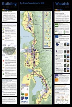
Wasatch CHOICE for 2040
 Wasatch CHOICE for 2040 Economic Opportunities We Can Choose a Better Future We enjoy an unparalleled quality of life along the Wasatch Front. People from all over the world are drawn to our stunning scenery,
Transportation. Strategies for Action
 Transportation A major priority for the Overlake Neighborhood is to develop a multimodal transportation system. To achieve this system, a balance has to be found among travel, circulation and access needs;
CHAPTER 7: Transportation, Mobility and Circulation
 AGLE AREA COMMUNITY Plan CHAPTER 7 CHAPTER 7: Transportation, Mobility and Circulation Transportation, Mobility and Circulation The purpose of the Transportation, Mobility and Circulation Chapter is to
GPA FALL 2017 CONFERENCE
 Change in Doraville Doraville at the beginning of a new era Design Doraville (Comp. Plan) adopted in 2016 Doraville Town Center Masterplan LCI (2005) Downtown Doraville Masterplan LCI (2010) 2014 Adoption
Gold Line Bus Rapid Transit Transit Oriented Development (BRTOD) Helmo Station Area Plan
 Helmo Station Area Plan") Appendix F Gold Line Bus Rapid Transit Transit Oriented Development (BRTOD) Helmo Station Area Plan Introduction and Purpose of the Plan The Gold Line Bus Rapid Transit facility is an eleven-mile dedicated
Appendix F Gold Line Bus Rapid Transit Transit Oriented Development (BRTOD) Helmo Station Area Plan Introduction and Purpose of the Plan The Gold Line Bus Rapid Transit facility is an eleven-mile dedicated
REVIEW AND EVALUATION OF REGIONAL LAND USE
 REVIEW AND EVALUATION OF REGIONAL LAND USE AND TRANSPORTATION SCENARIOS #220831 Environmental Justice Task Force October 7, 2014 VISION 2050 Process Development of Guiding Vision for Land Use and Transportation
DRAFT PLAN PRESENTATION
 DRAFT PLAN PRESENTATION 1.23.2018 AGENDA Process Project Schedule Results from Visioning Workshop Draft Plan Highlights Concept Plans Feedback Next Steps PROJECT SCHEDULE KICK-OFF WORKSHOP August 29 th
Implementation Guide Comprehensive Plan City of Allen
 Implementation Guide 2030 Comprehensive Plan City of Allen DRAFT 2015 Implementation Guide Allen 2030 Comprehensive Plan INTRODUCTION The Comprehensive Plan serves as a guide for the growth and development
Need for Regional Visioning
 Need for Regional Visioning Utah is one of the fastest growing states in the country. Population along the Wasatch Front is projected to increase by 55 percent, or to be 1.5 times the current population,
MONTGOMERY COUNTY METRO STATION AREA DESIGN CHARRETTE
 MONTGOMERY COUNTY METRO STATION AREA DESIGN CHARRETTE Shady Grove Metro Station Area Charrette Closing Presentation October 25-28, 2000 MONTGOMERY COUNTY, MD M-NCPPC Design Collective, Inc. Architects
Urban Planning and Land Use
 Urban Planning and Land Use 701 North 7 th Street, Room 423 Phone: (913) 573-5750 Kansas City, Kansas 66101 Fax: (913) 573-5796 Email: planninginfo@wycokck.org www.wycokck.org/planning To: From: City Planning
S C O P E O F W O R K A P R I L
 white flint 2 sector plan S C O P E O F W O R K A P R I L 2 0 1 2 MONTGOMERY COUNTY PLANNING DEPARTMENT M-NCPPC MontgomeryPlanning.org 1 white flint 2 sector plan Scope of Work abstract This scope of work
Town Center (part of the Comprehensive Plan)
") Town Center (part of the Comprehensive Plan) Mercer Island Town Center Looking North (2014) In 1994, a year-long process culminated in a set of design guidelines and code requirements for the Town Center
Town Center (part of the Comprehensive Plan) Mercer Island Town Center Looking North (2014) In 1994, a year-long process culminated in a set of design guidelines and code requirements for the Town Center
Transportation Projects Quarterly Report. Morrisville Planning Department May 22, 2018
 Transportation Projects Quarterly Report Morrisville Planning Department May 22, 2018 Transportation Improvements Most Common Ways the Town secures transportation improvements: 1. Development 2. Grant
Concord Community Reuse Project Goals and Guiding Principles. Overarching Goals (OG)
") Concord Community Reuse Project Goals and Guiding Principles Overarching Goals (OG) No priority is implied by the order of presentation of the goals and guiding principles. Overarching goals for the Concord
Concord Community Reuse Project Goals and Guiding Principles Overarching Goals (OG) No priority is implied by the order of presentation of the goals and guiding principles. Overarching goals for the Concord
Key Concepts of the General Plan
 Key Concepts of the General Plan General Plan Purpose Vision for City s future Standards for City Services Land Use Plan General Plan Purpose San Jose is creating its Blueprint for the Future to become
Atlanta BeltLine Corridor Environmental Study. Scoping Meeting August 2008
 Atlanta BeltLine Corridor Environmental Study Scoping Meeting August 2008 What Will We Be Discussing Today? Study Overview - How Did We Get Here? - What Is the Study About? - Who Is Involved? - Where Is
BROOKHILL NEIGHBORHOOD MODEL ZONING MAP AMENDMENT PREFACE TO APPLICATION
 BROOKHILL NEIGHBORHOOD MODEL ZONING MAP AMENDMENT PREFACE TO APPLICATION June 15, 2015 Revised: August 1, 2016 I. VISION Brookhill is a proposed community based upon the principles of Albemarle County
Plano Tomorrow Vision and Policies
 Plano Tomorrow Vision and Policies PLANO TOMORROW PILLARS The Built Environment The Social Environment The Natural Environment The Economic Environment Land Use and Urban Design Transportation Housing
ROBBINSDALE LRT STATION CDI DEVELOPMENT GUIDELINES
 August 2018 OVERVIEW The City of Robbinsdale has a prime-opportunity site in the middle of the 13 mile stretch of the Bottineau LRT corridor / Blue Line extension. Robbinsdale offers a prominent, vital,
RESOLUTION NO. R Refining the route, profile and stations for the Downtown Redmond Link Extension
 RESOLUTION NO. R2018-32 Refining the route, profile and stations for the Downtown Redmond Link Extension MEETING: DATE: TYPE OF ACTION: STAFF CONTACT: Capital Committee Board PROPOSED ACTION 09/13/2018
Silverdale Regional Center
 Silverdale Regional Center Vision for Silverdale Regional Center The Silverdale Regional Center Plan (Plan) will guide the evolution of the Silverdale Regional Center from a collection of strip malls and
Visioning Statement and Guiding Principles
 Visioning Statement and Guiding Principles Planning for the Future The General Plan The General Plan represents Woodland's shared vision of the future and defines a path to lead the community toward its
Rio/29 Small Area Plan. Design Plan & Implementation Framework Open House - January 25, 2018
 Rio/29 Small Area Plan Design Plan & Implementation Framework Open House - January 25, 2018 MEETING PURPOSE PRESENTATION 1. Orient to the updated design plans 2. Introduce implementing options 3. Explain
TREASURE COAST REGIONAL PLANNING COUNCIL M E M O R A N D U M. To: Council Members AGENDA ITEM 5H
 TREASURE COAST REGIONAL PLANNING COUNCIL M E M O R A N D U M To: Council Members AGENDA ITEM 5H From: Date: Subject: Staff October 17, 2008 Council Meeting Local Government Comprehensive Plan Review Draft
Robbinsdale LRT Station. CDI Development Guidelines. August Overview
 Robbinsdale LRT Station August 2018 Overview The City of Robbinsdale may have the coolest opportunity site along the 13 mile stretch of the Bottineau LRT corridor / Blue Line extension. Located a block
Northwest Rail Corridor and US 36 BRT Development Oriented Transit Analysis 4.4 STATION AREA FINDINGS
 4.4 STATION AREA FINDINGS Each station is different, and each one requires a separate set of recommendations based on the vision for the site. This section outlines an initial TOD strategy and recommendations
Atlanta BeltLine Subarea 3 Master Plan Update
 Atlanta BeltLine Subarea 3 Master Plan Update April 14, 2018 Workshop Meeting 1 22 miles, connecting 45 neighborhoods 22 MILES of transit 46 MILES of streetscapes and complete streets 33 MILES of urban
CITY OF UNION CITY MINUTES GENERAL PLAN ADVISORY COMMITTEE
 CITY OF UNION CITY MINUTES GENERAL PLAN ADVISORY COMMITTEE WEDNESDAY, MARCH 4, 2015, 6:30 P.M. IN THE CITY COUNCIL CONFERENCE ROOM OF CITY HALL 34009 ALVARADO-NILES BLVD., UNION CITY, CALIFORNIA Attachment
Transportation Land Use Integration & Regional Planning. Don Kostelec, AICP Senior Planner, Louis Berger Group February 1, 2010
 Transportation Land Use Integration & Regional Planning Don Kostelec, AICP Senior Planner, Louis Berger Group February 1, 2010 Transportation Land Use Integration DOT-HUD-EPA Sustainable Communities Initiative
REGIONAL ACTIVITY CENTER
 DRAFT REGIONAL ACTIVITY CENTER 70 EAST BENCH MASTER PLAN DRAFT 06 Introduction The East Bench Regional Activity center is comprised of large educational, research, medical, and employment centers. These
Point A Point B Point C Point D. City of Hapeville Public Meeting July 25, 2017
 City of Hapeville Public Meeting July 25, 2017 Fulton County Transit Master Plan Overview Following last year s ¾-cent TSPLOST effort, the Mayors of the 14 Cities outside of Atlanta and the Fulton County
City of Farmington. Downtown Plan. Amendment to the 1998 Master Plan Adopted October 11, 2004
 City of Farmington Amendment to the 1998 Master Plan Adopted October 11, 2004 Introduction Planning Background 1 Scope and Components of the Plan Amendment 2 Concept Introduction 3 Plan Concepts 3 Conceptual
12/9/2013. HOLLYWOOD/PINES CORRIDOR PROJECT AMPO 2013 Annual Conference October 24, Our Perspective. Broward.
 HOLLYWOOD/PINES CORRIDOR PROJECT AMPO 2013 Annual Conference October 24, 2013 Our Perspective Broward Fort Lauderdale 1 Broward Metropolitan Planning Organization Fort Lauderdale Fort Lauderdale Skyline
Dyersville Downtown Plan. Open House October 24, 2017
 Dyersville Downtown Plan Open House October 24, 2017 What is a Comprehensive Plan? - Vision - Guidance for decisions - Basis for regulations What is a Downtown Plan? - Understand priorities - Identify
Chapter 1.0 Introduction
 Chapter 1.0 Introduction 1.1 Background The North Metro commuter rail line is part of the RTD FasTracks regional transit system expansion program to build more than 100 miles of rail transit throughout
Atlanta BeltLine. Subareas 9 & 10. Master Plan Updates. March 26, Washington Park Jamboree 1
 Atlanta BeltLine Subareas 9 & 10 Master Plan Updates March 26, 2018 Washington Park Jamboree 1 22 miles, connecting 45 neighborhoods 22 MILES of transit 46 MILES of streetscapes and complete streets 33
Route 1 Corridor Study
 Route 1 Corridor Study Westbrook, Connecticut A Vision for the Connecticut Shoreline Public Informational Meeting July 28, 2015 Lower Connecticut River Valley Council of Governments Fitzgerald & Halliday,
BROOKLYN PARK / 85TH AVE LRT STATION CDI DEVELOPMENT GUIDELINES DRAFT
 August 2018 Page intentionally left blank The Brooklyn Park Library adjacent to the 85th Ave LRT Station Area. OVERVIEW The Blue Line LRT Extension / Bottineau corridor offers a unique opportunity to leverage
TOWN COUNCIL / PLANNING COMMISSION
 Workshop #3 TOWN COUNCIL / PLANNING COMMISSION January 20, 2011 Consultant Team In Attendance Tonight BMS Design Group Nevada City and San Francisco Michael Smiley, AICP, ASLA Partner-in-Charge Nancy L.
Sustainability, Health, Safety, Recreation & Open Space Working Group August 3, 2017
 Sustainability, Health, Safety, Recreation & Open Space Working Group August 3, 2017 DOWNTOWN OAKLAND SPECIFIC PLAN WELCOME Sustainability, Health, Safety, Recreation & Open Space Working Group Social
Secrest Short Cut and Monroe Expressway Small Area Plan AUGUST 29, 2018
 Secrest Short Cut and Monroe Expressway Small Area Plan AUGUST 29, 2018 Background and Process Monroe Expressway will be open by the end of 2018 Union County and Indian Trail identified a need to revisit
Description of Preferred Alternative
 Chapter 2 Description of Preferred Alternative 2.1 Introduction This chapter of the programmatic Sammamish Town Center Sub-area Plan Final EIS provides a more detailed description of the Preferred Alternative
Subregion 4 Central Avenue-Metro Blue Line Corridor Transit-Oriented Development (TOD) Implementation Project. Community Meeting April 27, 2011
 Implementation Project. Community Meeting April 27, 2011") Subregion 4 Central Avenue-Metro Blue Line Corridor Transit-Oriented Development (TOD) Implementation Project Community Meeting April 27, 2011 Overview Introduction to Subregion 4 TOD Implementation Program
Subregion 4 Central Avenue-Metro Blue Line Corridor Transit-Oriented Development (TOD) Implementation Project Community Meeting April 27, 2011 Overview Introduction to Subregion 4 TOD Implementation Program
Seneca Meadows. Block 4 Locate office, technology, and medical development adjacent to I Screen views of garage structures from I-270.
 Seneca Meadows Seneca Meadows has an industrial park in its southern end and a mixed-use employment area planned for the north end. The district benefits from extensive I-270 visibility, stream valley
DRAFT MAJOR CORRIDORS 48 EAST BENCH MASTER PLAN
 DRAFT MAJOR CORRIDORS 48 EAST BENCH MASTER PLAN DRAFT 05 Introduction Foothill Drive, Parley s Way, Sunnyside Avenue and 1300 East serve as thoroughfares into the City and are important pieces in the regional
Ashland BRT Environmental Assessment: logos of CTA, CDOT, Chicago Department of Housing and Economic Development
 Ashland BRT Environmental Assessment: logos of CTA, CDOT, Chicago Department of Housing and Economic Development Overview The Chicago Transit Authority (CTA), in partnership with the Chicago Department
The University District envisions, in its neighborhood
 Envisioning the University District Link Light Rail in Seattle s neighborhoods CIY OF SEALE CONCEP-LEVEL SAION AREA PLANNING RECOMMENDAION RESOLUION # 30165 EXHIBI L Vision 08.2000 he University District
Corridors. Re-vitalize our Corridors and Gateways
 Corridors Re-vitalize our Corridors and Gateways Artist s rendering from the 287 Strategic Plan, 2015 Corridors are the major throughways of Loveland but they also provide important commercial, community
Further input invited as Colchester Growth Strategy nears final phase
 IUE 3 / NOVEMBER 2015 Further input invited as Colchester Growth trategy nears final phase trathcona County is seeking public feedback as it enters the final phase of work on a Growth Management trategy
Corridor Vision. 1Pursue Minnehaha-Hiawatha Community Works Project. Mission of Hennepin County Community Works Program
 1Pursue Minnehaha-Hiawatha Community Works Project Minnehaha-Hiawatha Community Works is a project within the Hennepin Community Works (HCW) program. The mission of the HCW program is to enhance how the
Welcome. Comprehensive Plan & Transportation Plan Open House November 7, 2012
 Welcome Comprehensive Plan & Transportation Plan Open House November 7, 2012 Agenda Proposed future land use plan Comprehensive Plan strategies Traffic forecasts Future traffic operations Possible future
Germantown Forward Status Report to the Planning Board M NCPPC
 Germantown Forward Status Report to the Planning Board Germantown Forward March 27, 2008 What s new? CCT alignment Capital Improvement Program Agency partners Water quality conditions Sustainability Design
The Lincoln Neighborhood Corridor Plan. The LiNC
 October 1, 2014 Planning Commission Study Session The Lincoln Neighborhood Corridor Plan The LiNC Purpose of Tonight s Meeting Introduction to The LiNC Review of Existing Conditions and Community Identified
COURTICE MAIN STREET COMMUNITY IMPROVEMENT PLAN
 COURTICE MAIN STREET COMMUNITY IMPROVEMENT PLAN Public Meeting #1 April 28, 2016 Birdseye view of the study area PIC #1 AGENDA Agenda and Format 6:30 6:50 Registration 6:50 7:45 Introductions, Presentation
Mobility Districts and Traffic Studies
 Mobility Districts and Traffic Studies During the last Comprehensive Plan update in 2008, the City of Sarasota identified the need to develop a citywide strategy for enhancing the mobility options of all
Tysons Circulator Study: Process and Preliminary Results Summary. March 2012
 Tysons Circulator Study: Process and Preliminary Results Summary March 2012 Background: 1. The Comprehensive Plan for the Tysons Corner Urban Center calls for a System of Circulators in Tysons Corner to:
CITY OF CHARLOTTESVILLE, VIRGINIA CITY COUNCIL AGENDA
 CITY OF CHARLOTTESVILLE, VIRGINIA CITY COUNCIL AGENDA Agenda Date: December 16, 2013 Action Required: Adoption of Resolution Presenter: Staff Contacts: Title: James E. Tolbert, AICP, Director of NDS James
A BLUEPRINT FOR BROCKTON A CITY-WIDE COMPREHENSIVE PLAN
 A BLUEPRINT FOR BROCKTON A CITY-WIDE COMPREHENSIVE PLAN Public Meeting October 2016 1 Plan Summary and Discussion Public Meeting May 4 2017 City of Brockton Bill Carpenter, Mayor Department of Planning
Status Update (2006 vs. Now) Citizen s Advisory Committee February Plan for Prosperity
 Citizen s Advisory Committee February Plan for Prosperity") Status Update (2006 vs. Now) Citizen s Advisory Committee February 2018 Plan for Prosperity 2000 2017 2000 2017 Gardnerville Population 6,000 5,760 5746 5,500 5,000 5,067 5,550 5,165 5,394 5,412 5,250
Status Update (2006 vs. Now) Citizen s Advisory Committee February 2018 Plan for Prosperity 2000 2017 2000 2017 Gardnerville Population 6,000 5,760 5746 5,500 5,000 5,067 5,550 5,165 5,394 5,412 5,250
Introduction. Chapter 1. Purpose of the Comprehensive Plan Plan Organization Planning Process & Community Input 1-1
 Chapter 1 Introduction Lakewood 2025: Moving Forward Together Purpose of the Comprehensive Plan Plan Organization Planning Process & Community Input 1-1 Purpose of the Comprehensive Plan The Comprehensive
INDEPENDENCE BOULEVARD AREA PLAN
 INDEPENDENCE BOULEVARD AREA PLAN Public Meeting October 28, 2008 Tonight s Agenda Introduction 4:00 4:05 Tom Warshauer Presentation 4:05 5:00 Blake Drury Group Exercises 5:00 5:50 All Wrap Up & Next Steps
Chapter 1: Introduction
 Chapter 1: Introduction The Penn Avenue Community Works Corridor Vision and Implementation Framework presents an integrated communitybased vision and a coordinated, long-term implementation framework for
PINE CURVE REZONING. BACKGROUND Purchased as two parcels in 2001 and 2002
 BACKGROUND Purchased as two parcels in 2001 and 2002 WHAT THE PROJECT IS AND IS NOT A Rezoning establishes the land use standards for Annexed and Zoned Greater Downtown District Historic Center September
Public input has been an important part of the plan development process.
 Lakewood s Comprehensive Plan recognizes that transportation helps shape the community, and that the way the community provides for the safe and efficient movement of people affects the character of the
North Salt Lake General Plan Update 2013
 North Salt Lake General Plan Update 2013 Acknowledgements Updating the North Salt Lake General Plan was a process that would not have been possible without the support of elected officials and the general
Evaluation Criteria. Detailed Evaluation Criteria
 Evaluation Criteria Detailed Evaluation Criteria Community Well-being A safe and socially inclusive service that improves access to key community destinations and provides transportation choices for Calgarians.
Ann Arbor Intermodal Station Environmental Review
 Ann Arbor Intermodal Station Environmental Review Park Advisory Commission September 19, 2017 AGENDA 1. Project Update 2. Draft Environmental Assessment 3. Draft Preferred Alternative 4. Next Steps 5.
Town of Oakville Streetscape Strategy
 Town of Oakville Streetscape Strategy Endorsed by PDC on February 10, 2014 (PD-011-14) Town of Oakville Streetscape Strategy [endorsed by PDC February 10, 2014] 0 Town of Oakville Streetscape Strategy
Newton Town Centre. Land Use, Urban Design & Transportation Plan
 Newton Town Centre Land Use, Urban Design & Transportation Plan Public Workshop - June 2-4, 2009 6:15 6:30 Sign-in & conversations Tonight s Agenda 6:30 6:55 Project introduction and summary of previous
Lesson 6. Corridor Planning
 Lesson 6 Corridor Planning 1 Learning Outcomes Identify land use strategies and solutions that can be incorporated into multimodal transportation corridor plans Identify land use stakeholders and describe
12 th Street Connector Alignment Study VISIONING PUBLIC WORKSHOP - JUNE 25, :00PM TO 8:00PM
 12 th Street Connector Alignment Study VISIONING PUBLIC WORKSHOP - JUNE 25, 2018 6:00PM TO 8:00PM Goals for Today s Workshop Agenda: Project Introduction, Purpose, and Goals Existing Conditions Traffic
THE NEIGHBORHOOD TODAY
 THE NEIGHBORHOOD TODAY CORE AREA VISION How are we Good Urbanism A Site s DNA thinking about Elements of great Unique elements urban communities embedded in a place the site and design? ELEMENTS LIKE:
Scope of Services. River Oaks Boulevard (SH 183) Corridor Master Plan
 Corridor Master Plan") Scope of Services River Oaks Boulevard (SH 183) Corridor Master Plan PROJECT AREA The project area consists of the River Oaks Boulevard (SH 183) corridor bounded by SH 199 at the northern end and the Trinity
Scope of Services River Oaks Boulevard (SH 183) Corridor Master Plan PROJECT AREA The project area consists of the River Oaks Boulevard (SH 183) corridor bounded by SH 199 at the northern end and the Trinity
3. ELEMENTS OF THE METRO VISION 2035 PLAN
 3. ELEMENTS OF THE METRO VISION 2035 PLAN What is Metro Vision and why does it matter? For more than 50 years, DRCOG has championed a regional perspective on key issues facing the metropolitan area and
PINE CURVE REZONING. Property does not meet criteria for open space preservation and is not a candidate for a park
 PINE CURVE REZONING BACKGROUND Purchased as two parcels in 2001 and 2002 Annexed and Zoned Greater Downtown District Historic Center September 25, 2002 and October 7, 2002 WHAT THE PROJECT IS AND IS NOT
Hillsborough County MPO Transit Study. Citizens Team Workshop Wednesday, February 28 th, 2006 Hillsborough Community College - Brandon
 Hillsborough County MPO Transit Study Citizens Team Workshop Wednesday, February 28 th, 2006 Hillsborough Community College - Brandon What is the MPO Transit Study? An effort to look at the full range
Northwest commuter rail station US 36 BRT. Westminster Station
 Northwest commuter rail station Westminster Station US 36 BRT Westminster Center US 36 & Church Ranch Broomfield Flatiron/96 th St. US 36 & McCaslin Table Mesa Boulder Junction 13-month effort that will
Welcome! to Keller Town Hall
 Welcome! to Keller Town Hall Keller Town Center Planning a New Downtown What is Keller Town Center? A new, growing downtown district planned as an urban village A combination of retail and office spaces,
Welcome. Green Line LRT. Beltline Alignment Options. Stay engaged! Follow the Green Line story at calgary.ca/greenline
 Welcome Green Line LRT Beltline Alignment Options Stay engaged! Follow the Green Line story at calgary.ca/greenline Green Line LRT Why are we here? Our Challenge Determine the best alignment in the Beltline.
MORRISVILLE TRANSPORTATION PLAN TOWN COUNCIL PRESENTATION AUGUST 22, 2017
 TOWN COUNCIL PRESENTATION AUGUST 22, 2017 SCENARIO PLANNING CORRIDORS Town Hall Drive Baseline + 2 McCrimmon Parkway Baseline + 2 NC 54 Baseline + 2 7 subregion model runs determining carrying capacity
DELIVERING ON THE TRANSIT PROMISE
 DELIVERING ON THE TRANSIT PROMISE Dena Belzer October 6, 2015 Presentation Overview 1. Puget Sound As a Transit Region: Putting SeaTac in Context 2. Starting at the Beginning: How Does TOD Work? 3. Strategies
Broadway District Specific Plan. Community Workshop #2 February 23,2016
 Broadway District Specific Plan Community Workshop #2 February 23,2016 1 Agenda Introductions Project Progress Status Upcoming Milestones Emerging Framework Land Use Urban Design Circulation Infrastructure
Executive Summary. NY 7 / NY 2 Corridor
 Executive Summary NY 7 / NY 2 Corridor Transportation and Land Use Study December 2005 Prepared for: Town of Colonie Capital District Transportation Committee Prepared by: Introduction: Land use decisions
Subareas 9 & 10 Master Plan Updates
 Atlanta BeltLine Subareas 9 & 10 Master Plan Updates Study Group Meeting 4 September 17, 2018 Washington Park Jamboree 1 22 miles, connecting 45 neighborhoods 22 MILES of transit 46 MILES of streetscapes
Tricia Millington, RLA New York State Department of Transportation
 Tricia Millington, RLA New York State Department of Transportation pmillington@dot.state.ny.us Context Sensitive Principles: Context Sensitive Solutions is a philosophy wherein safe transportation solutions
Welcome to the LYNX Blue Line Extension Transit Station Area Plans Public Workshop No. 3. Presentation will begin at 6:00 P.M.
 Welcome to the LYNX Blue Line Extension Transit Station Area Plans Public Workshop No. 3 Presentation will begin at 6:00 P.M. Meeting Agenda Blue Line Extension (BLE) Project Update LYNX Blue Line Extension
1.0 VISION STATEMENT. December 6, PRINCIPLES
 Vision Statement Lincoln Regional Airport 1.0 VISION STATEMENT 1.1 City LOCATION of AND OVERVIEW The Easton Lincoln Place Land Use Master Plan identifies the principles, goals, policies, and standards
Economic Development & Housing Council Committee Comprehensive Plan Update September 20, 2005
 1 Economic Development & Housing Council Committee Comprehensive Plan Update September 20, 2005 Purpose To update the Committee on the ForwardDallas! Plan, including: Status Anticipated Products Public
CHAPTER 3 VISION, GOALS, & PLANNING PRINCIPLES. City of Greensburg Comprehensive Plan. Introduction. Vision Statement. Growth Management Goals.
 CHAPTER 3 VISION, GOALS, & PLANNING PRINCIPLES Introduction The Greensburg Comprehensive Plan is intended as a working community document. A combination of long and short-term goals, this document is intended
S A C R A M E N T O C O U N T Y JACKSON HIGHWAY & GRANT LINE EAST VISIONING STUDY
 JACKSON HIGHWAY & GRANT LINE EAST S A C R A M E N T O C O U N T Y P L A N N I N G D E P A R T M E N T SUMMARY AND WORKBOOK November 19, 2008 History of the Visioning Study Sacramento County has two growth
Access to the University of North Carolina at Chapel Hill, UNC Hospitals, and Chapel Hill Transit.
 M 1/ 4 1/ 2 E IL M E IL Station Family: County: City: UNC Hospitals WHY THIS STATION? University Village Orange Chapel Hill Access to the University of North Carolina at Chapel Hill, UNC Hospitals, and
Draft Memorandum #1: Goals and Vision for Revitalization
 Keizer Revitalization Plan Draft Memorandum #1: Goals and Vision for Revitalization Submitted to: City of Keizer April 12, 2018 (revised) Prepared By: Angelo Planning Group and Otak, Inc. Project No. 17482.A
UAA School of Engineering Parking Garage Master Plan Amendment. 1. Purpose
 UAA School of Engineering Parking Garage Master Plan Amendment 1. Purpose Since the UAA campus master plan was drafted in 2003, adopted in 2004, and amended in 2009 a number of significant changes regarding
3.1 community vision. 3.3 required plan elements
 Chapter 3 Community Form 3.1 community vision 3.2 Parks & landscaping concepts 3.3 required plan elements D R A F T 20 Community Form Chapter 3 3.0 Community form 3.1 community vision The Specific Plan
Mount Pleasant Comprehensive Plan Public Open House Meeting. June 5, 2018
 Mount Pleasant Comprehensive Plan Public Open House Meeting June 5, 2018 The Planning Team Town Staff Liz Boyles - Principal Planner Brad Morrison - Transportation Director Christiane Farrell Assistant
A Plan for the Heart of the Region: Tukwila, WA
 : Tukwila, WA 1 The Plan orchestrates the Restructuring of a 1,000-acre Regional Shopping Area into a Social and Symbolic for the Region. REGIONAL CONTEXT Downtown Seattle (Metropolitan ) 20 miles Bellevue