This page intentionally left blank
|
|
|
- Tiffany Brooks
- 5 years ago
- Views:
Transcription
1
2 This page intentionally left blank

3 Page 3 of 18
4 This page intentionally left blank
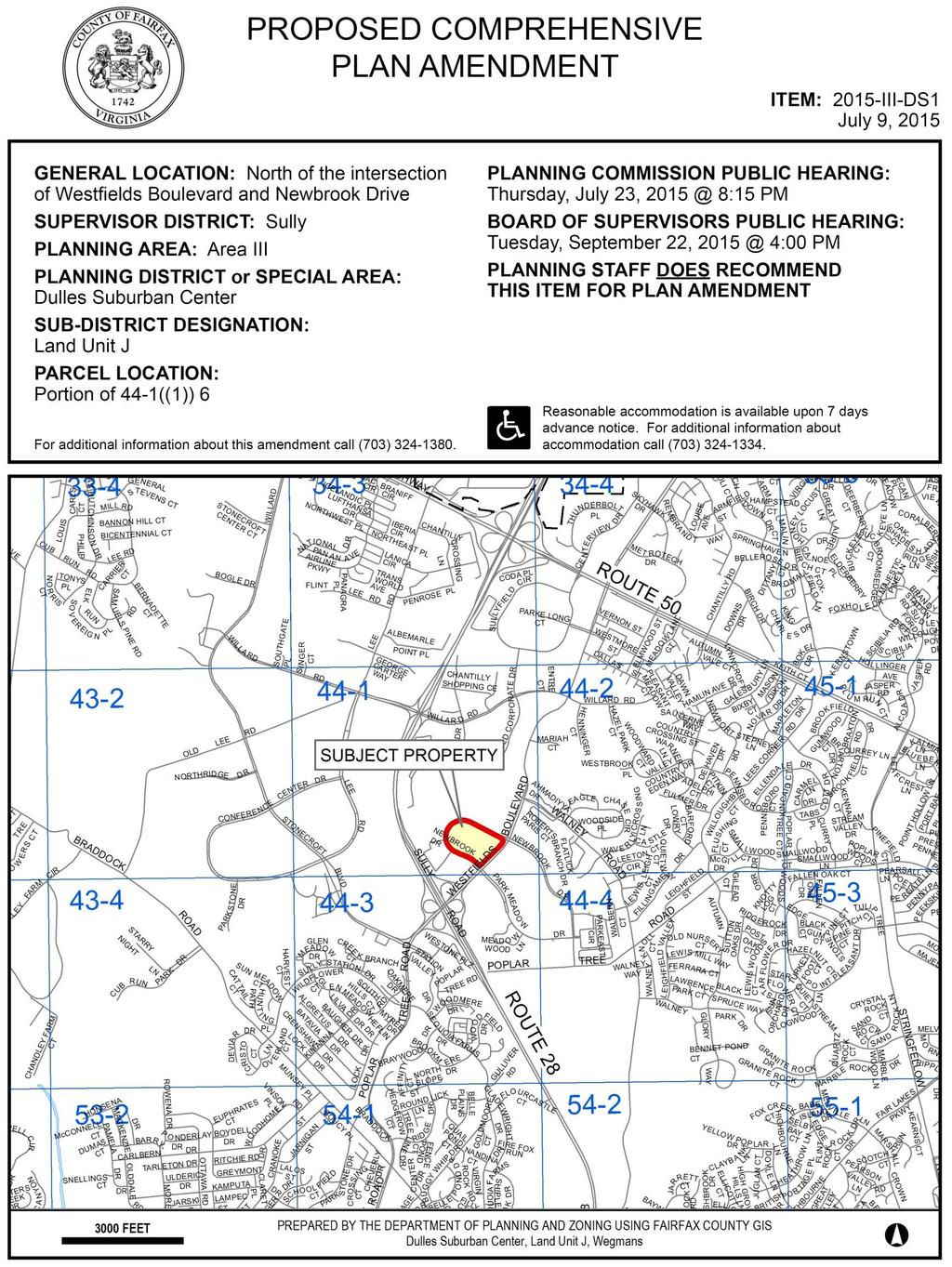
5 STAFF REPORT FOR PLAN AMENDMENT 2015-III-DS1 BACKGROUND On January 13, 2015, the Fairfax County Board of Supervisors (Board) authorized Plan Amendment (PA) 2015-III-DS1 for a portion of Tax Map Parcel 44-1((1))6, located north of the intersection of Westfields Boulevard and Newbrook Drive/Park Meadow Drive, east of Route 28, in Land Unit J of the Dulles Suburban Center in the Sully Supervisor District. The Board authorized staff to consider a Plan Amendment for retail uses up to approximately 180,000 square feet. In addition, the Board directed staff to examine impacts on the road network and improvements needed to alleviate such impacts. Further, the staff was directed to conduct concurrent review of Proffered Condition Amendment (PCA) application 2006-SU The current Comprehensive Plan recommends a mix of uses including office, conference center/hotel, industrial/flex and industrial uses at an average.50 FAR. CHARACTER OF THE AREA The Dulles Suburban Center (Figure 1) comprises over 6,000 acres in western Fairfax County adjacent to Washington Dulles International Airport. Employment associated with office and industrial/flex uses is concentrated in this area. Land Unit J consists almost entirely of the Westfields International Corporate Center at Dulles. Planned for campus-style office, conference center, hotel, industrial and industrial/flex space, the land unit exceeds 1,000 acres. The area is developed and promoted as a Class A, corporate office park with companies such as Lockheed Martin, Northrop Grumman, and the Aerospace Corporation having a presence there. The subject property is part of Commonwealth Centre, approximately 100 acres that includes the area that is both within and outside of the planned Newbrook Drive loop road north-west of Westfields Boulevard. Commonwealth Center is approved for a mix of uses that includes six office buildings, two hotels and additional office, support retail and restaurant uses. To the west of the subject property, two of the office buildings and a parking structure have been constructed as shown in Figure 2. The rest of the property, including the area subject to this Plan amendment, remains vacant. The area to the north and northeast of the subject property is vacant land beyond which is extensive Environmental Quality Corridor (EQC) associated with Flatlick Branch. Page 1 of 18

6 Staff Report for Plan Amendment 2015-III DS1 Figure 1: Subject Property in Land Unit J of the Dulles Suburban Center Page 2 of 18
.")
7 2015-III-DS1 Subject Property, Dulles Suburban Center, Land Unit J Flight Date March 2013 Figure 2: Aerial View of Subject Property PLANNING HISTORY Since the Planning Horizons process of the early 1990s, Land Unit J of the Dulles Suburban Center has been planned for office, conference center/hotel, industrial/flex and industrial uses at an average intensity of.50 floor area ratio (FAR). On November 25, 1985, the Board of Supervisors approved RZ 78-S-063 (Westfields), rezoning acres, including the subject property, from R-C, I-3, I-4 and I-5 Districts to the I-3, I-4 and I-5 Districts. This rezoning was subject to proffers, but a development plan was not proffered. What was later to become the Commonwealth Centre property was zoned I-3 and approved for a maximum intensity of.5 FAR. On October 3, 2007, the Board of Supervisors approved FDP 2006-SU-025 (Commonwealth Centre) for mixed-use development on acres, which included the subject property. The mix included office (1,126,500 sq. ft.), hotel (212,000 sq.ft.) and retail (76,400 sq. ft.) uses for a total of 1.42 million square feet at an intensity of.32 FAR. Subsequent amendments modified portions of these approvals and included allowance for structured parking decks and flexibility to Page 3 of 18

8 Staff Report for Plan Amendment 2015-III DS1 include a child-care facility to the mix. Figure 3 is from the approved Final Development Plan and shows the site layout. Figure 3: Commonwealth Centre Approval, July 13, 2009 On March 20, 2015, PCA 2006-SU was accepted for review for the subject property. The proposal is to remove hotel (212,000 sq. ft.), retail (76,400 sq. ft.) and office (50,000 sq. ft.) uses that are approved for the area within the planned Newbrook Drive loop and replace it with 180,000 sq. ft. of retail uses. Since this proposed change in uses is not in conformance with the adopted Comprehensive Plan, the review of this PCA application has occurred concurrently with the review of the proposed Plan amendment, which was authorized to evaluate the conditions under which an option for retail use may be appropriate for this site. ADOPTED COMPREHENSIVE PLAN TEXT The Comprehensive Plan Map shows this property is planned for mixed-use development. Specific Plan text for Land Unit J of the Dulles Suburban Center, which includes the subject property, recommends a mix of non-residential uses. The Plan text is cited below. Page 4 of 18
9 Fairfax County Comprehensive Plan, 2013 Edition, Area III, Dulles Suburban Center, as amended through June 2, 2015, Land Unit J, Land Use, Recommendations, page 141. Land Use 1. Land Unit J is planned and approved for office, conference center/hotel, industrial/flex and industrial use at an average of.50 FAR except as noted in Land Use Recommendations #6 and #7 below. Future development should be consistent with the character of the existing development. High quality landscaping should be maintained throughout the land unit. It is desirable that development in this land unit be designed to enhance transit serviceability. This can be achieved by placing buildings closer together or to the road; designing them around plazas; utilizing approaches to bring employees within walking distance of transit facilities or otherwise facilitating transit-oriented development. The Dulles Suburban Center Plan may be viewed in its entirety online. PROPOSED PLAN AMENDMENT The adopted Plan for the subject property recommends a mix of uses that include office, conference center/hotel, industrial/flex and industrial use at an average of.50 FAR. As stated previously, the Board authorized staff to consider a Plan Amendment for retail uses up to approximately 180,000 square feet. In addition, the Board directed staff to examine impacts on the road network and any improvements needed to mitigate such impacts. ANALYSIS This Plan amendment considers the subject property in the context of the larger mix of uses in Land Unit J, the extent to which it furthers Dulles Suburban Center Plan land use and transportation objectives, and conformance with the performance based strategy for optional uses. Specific considerations include the potential impact of additional retail uses on the transportation network and how the new use should relate to existing and planned uses in the area. Land Use Development in Land Unit J is primarily high quality, campus-style office buildings with approximately 80 percent of the development consisting of office uses. The dominance of a single type of land use in Land Unit J and in the larger Dulles Suburban Center has contributed to an imbalance between land use and transportation. Since at least the 1990s, the Comprehensive Plan has acknowledged that the estimated maximum non-residential development potential for the Dulles Suburban Center exceeds that which can be served at acceptable levels of service by the planned roadway network in this area. Reducing demand on Page 5 of 18
10 Staff Report for Plan Amendment 2015-III DS1 the roadway system is a priority. As stated in the Dulles Suburban Center Plan, one strategy to reduce demand is to encourage land uses that produce fewer peak hour trips compared to office development. This is one reason that the Dulles Suburban Center Plan includes the Performance Based Strategy for Optional uses which, as the Plan states, provides the opportunity for a broader range of uses if it can be clearly demonstrated that the uses will have lesser peak-hour impacts than would be generated if the site were developed at the baseline Plan recommendation and that the uses are compatible with adjacent development and of a high quality that will contribute to the image and economic vitality of the Dulles Suburban Center. Another objective of the Dulles Suburban Center Plan is to incorporate a variety of housing opportunities within and near the Dulles Suburban Center, which promotes economic diversity and supplies a variety of workers for nearby jobs. The Plan further indicates that residential development should create a high-quality living environment with good design, recreation and other amenities. Single-family neighborhoods are located less than a half-mile drive or walk to the east. Located less than a mile to the west, are existing single-family neighborhoods with the potential for more housing planned. Considering the Plan objectives to incorporate housing where appropriate and the close proximity of existing neighborhoods to the east and west, a welldesigned retail development at this location creates the opportunity for a land use that serves both existing and future residents and office workers in the area. If restaurant and grocery store uses are introduced, such as those proposed in PCA 2006-SU , these would contribute to creating a more vibrant mix of uses for the immediate area with day and nighttime activity. High quality retail development at this location that is designed to be functionally integrated and compatible with surrounding uses could meet the objective of contributing to the image and economic vitality of the Dulles Suburban Center. Design Guidelines The high quality character of development will be evaluated based on its ability to meet the Design Guidelines for the Dulles Suburban Center. These are intended to facilitate the integration of new development with the existing and future development in the area and to ensure that the various land uses function well together from the point of view of the user. Design guidance in the Plan that is particularly relevant for the proposed use include provision of substantial and usable open space and designing retail shopping development in physically unified complexes, not as scattered free-standing structures. Design guidelines further state that development should include safe separate pedestrian and vehicular circulation patterns for retail development, to encourage shoppers to walk from store to store. Parking should be minimized in front of buildings when it is not possible to use structured parking. Further, large parking lots should be screened and broken into smaller lots by using planting areas as dividers. Provision of a continuous open space system linking activity nodes internally and externally is encouraged. Architectural design guidance encourages the creation of an architectural theme and incorporation of plazas at major building entrances or in the center of a group of buildings. The Page 6 of 18
11 plazas could feature seating and other pedestrian amenities with a focal point such as a water feature or public art. The subject property has a landscaped buffer along Westfields Boulevard with existing mature trees. This buffer is consistent with streetscape that exists in other areas in Land Unit J. Retaining that buffer creates the opportunity to preserve the continuity and compatibility with other Westfields development. Transportation The transportation network in this area currently experiences failing conditions at several intersections and intersection turning movements in the vicinity of the site. Road Network Impact The transportation analysis for the Plan amendment compared the approved 338,400 square feet of hotel, shopping center (first floor retail) and office uses to the proposed 183,000 square feet of retail (Figures 4 and 5) assuming a large grocery store and other retail uses. Using the Institute of Traffic Engineers (ITE) 2013 Handbook, the results of the analysis indicate that the proposed retail development would generate more trips when compared to the currently approved uses. The daily vehicles generated by the site increase by 5,588 trips compared to the currently approved land uses. This represents a 63% increase in daily vehicle trips generated by the site. During the morning and evening peak hours, the proposed uses increase trips by approximately 55% when compared to the currently approved uses. Figure 4: Trip Generation Estimates for 2007 Approved Hotel, Retail and Office Uses ITE Category Square Feet Daily AM Peak Hour PM Peak Hour In Out Total In Out Total Hotel 212,000 2, Shopping Center 76,400 5, Office 50, Totals 8, Figure 5: Trip Generation Estimates for Proposed Retail Scenario ITE Category Square Feet Daily AM Peak Hour PM Peak Hour In Out Total In Out Total Supermarket 140,000 9, Retail, Bank, Shopping Center 43,000 4, Totals 14, ,422 Page 7 of 18
12 Staff Report for Plan Amendment 2015-III DS1 To understand the full range of trip generation impacts resulting from the proposed retail uses, an additional comparison was made to an office development scenario as shown in Figure 6. The scenario assumes that no site constraints would limit office development on the property and that the maximum Plan intensity of.50 FAR could be achieved resulting in 457,380 square feet of office use. A typical office trip-generation rate was assumed. The results show that the daily vehicles generated by the proposed retail generate 9,396 more daily trips when compared to the maximum office use potential. This represents a 186% increase in daily trips generated by the site. During the morning peak hour the proposed retail decreases trips by approximately 3%, and in the evening peak hour increases trips by 109% when compared to the maximum office use potential. The number of morning peak hour trips accessing the site is reduced; however, trips leaving the site in the morning do increase. During the evening peak hour, there are more vehicles that enter and leave the site with the proposed retail development. Figure 6: Trip Generation Estimates for Office at.5 FAR, on 21 Acres ITE Category Square Feet Daily AM Peak Hour PM Peak Hour In Out Total In Out Total Office 457,380 5, The analysis shows that changing the site s use to the proposed retail uses would increase the number of vehicles on the surrounding roadways. This increase would result in delays above those currently experienced during the morning and evening peak hours, and delays above what would occur with previously approved or planned uses. Development that results in an increase in trips is inconsistent with Dulles Suburban Center Plan guidance, which has a land use strategy encouraging uses that have lower peak hour trips than base level planned office use. Therefore, it is critically important that this proposed change to the Plan incorporate provisions to help ensure that transportation improvements to the area roads and intersections be provided to offset the impact the proposed development has on the adjacent roadway network. The Board authorization for the Plan Amendment indicated that there should be a traffic analysis to examine and identify the improvements needed to minimize the impact on the transportation network by the proposed use. Review of PCA 2006-SU has included the review of a traffic impact analysis study, which showed how the road network would perform with previously proffered transportation improvements and with additional improvements that were identified as part of the study. The previously proffered improvements include, among others, construction of a raised median on Westfields Boulevard, construction of an additional westbound travel lane on Westfields Boulevard, the completion of the Newbrook Drive loop road and signal re-timing and coordination. If improvements identified in the analysis are implemented, they do help mitigate the burden that the new use puts on the transportation network. However, additional improvements may be needed to fully mitigate the potential transportation impacts and improve the operation of the road network. Page 8 of 18

13 Transit Service The Fairfax Connector Routes 640 and 642 stop in front of the site on Westfields Boulevard. Route 642 stops in the area every half hour during the morning and evening peak periods and Route 640 provides hourly service on weekdays during the off peak hours. There is no weekend bus service to the site. Provision of safe and direct pedestrian routes to the bus stop would make it easier for future employees and shoppers to access the site by way of transit. Bicycle and Trail Facilities The County Bicycle Master Plan recommends a Shared Use Path on the south side of Westfields Boulevard. The path is to extend east, connecting to an existing trail in the Frog Branch Stream Valley Park and planned bike lanes along Walney Road. The path also is planned to extend west to connect to planned bike paths along Stonecroft and Westfields Boulevards. There is an existing network of pedestrian connections and trails throughout the Westfields Business Park. There are major paved trails planned on either side of the subject property, as shown on Figure 7, that are intended to connect Westfields Boulevard and uses on either side of Newbrook Drive to the planned stream valley trail to the north. This site has the opportunity to integrate additional pedestrian facilities and multi-use trails to connect to this regional trail and bicycle network. Figure 7: Fairfax County Countywide Trails Plan, Adopted 10/28/2014 Page 9 of 18
14 Staff Report for Plan Amendment 2015-III DS1 Other Fire and Rescue: The subject property is located in the emergency response area of the Chantilly Fire and Rescue Station 15. The next closest fire station is the West Centreville Fire and Rescue Station 38. Heavy peak-hour traffic congestion in the area is a challenge for emergency responders. Installation of preemption equipment on traffic signals would improve response times to emergency incidents. Sanitary Sewer: Sewage generated within the subject property is treated at the Upper Occoquan Service Authority treatment plant. The County s existing allocation at the treatment plant is capable of handling the projected anticipated sewage flow through The trunk lines within the area have adequate capacity to handle the project flow as well. Cultural Resources: The Wren-Hutchinson House and Cemetery (VA state site #44FX1096) were located on this parcel, though not necessarily on the portion of the parcel that is subject to the Plan Amendment. The cemetery has been relocated, but any redevelopment of the parcel should take into account that additional graves may exist. CONCLUSION The Plan amendment considers an option for a large retail development that encourages the creation of a high-quality development, contributes to a mix of uses, and promotes pedestrian activity that serves this site and Commonwealth Centre as a whole. This development has the potential to become a central amenity for the office and residential uses in the surrounding area. Development proposed under this Plan option should be consistent with the Performance Based Strategy for Optional Uses. It should have lesser peak-hour transportation impacts than the baseline Plan, should be compatible with adjacent development and should be of a high quality that contributes to the image and economic vitality of the Dulles Suburban Center. The Plan section on the Performance Based Strategy for Optional Uses is included in Appendix I. The Performance Criteria for Optional Uses section of the Dulles Suburban Center Plan is included at Appendix II. As shown in the transportation analysis, implementation of this retail option may result in more peak hour trips than the baseline plan. The benefit of fostering a mix of uses and providing retail uses proximate to nearby and growing residential areas may be sufficient to justify an increase in vehicle trips if impacts to the transportation network are offset through improved operation of the road network. In reflection of this, the proposed Plan guidance includes flexibility to consider retail uses that generate more vehicle trips than the current Plan if the development includes mitigation of the transportation impact. If this cannot be achieved, the Plan guidance encourages the consideration of off-site transportation improvements or a reduction in the amount of development. Application of the Design Guidelines for Dulles Suburban Center will encourage high-quality building and site design in future development. Additional plan guidance that addresses site and building design and interparcel connectivity is proposed to ensure that a high-quality pedestrian Page 10 of 18
15 oriented development is achieved. Further, enhanced connectivity to the existing and planned pedestrian and bicycle network would help make it safe and convenient for people to access transit and the proposed retail uses without needing the use of a motor vehicle. The addition of a retail option is consistent with stated major objectives in the Plan. Chief among them is the land use objective to promote a high quality of life for those who work and reside in or near the Dulles Suburban Center. A retail environment that includes features such as plazas and open space could serve as an amenity for the existing and planned uses in the area. RECOMMENDATION Staff recommends the Comprehensive Plan modification shown below. Text proposed to be added is shown as underlined and text proposed to be deleted is shown with a strikethrough. Text shown to be replaced is noted as such. ADD: Fairfax County Comprehensive Plan, 2013 Edition, Area III, Dulles Suburban Center, as amended through June 2, 2015, Land Unit J, Land Use, Recommendations, new recommendation #8, page 145: 8. Parcel 44-1((1)) 6 is approximately 73 acres that is a part of the Commonwealth Centre development, located north of the Westfields Boulevard and Newbrook Drive/ Park Meadow Drive intersection. Like other property in Land Unit J, this parcel is planned for office, conference center/hotel, industrial/flex and industrial use up to an intensity of.50 FAR. As an option, retail uses may be appropriate up to an intensity of.20 FAR on 21 acres located north of Westfields Boulevard. The following conditions should be met to implement this option: In order to create a sense of place, a network of well-connected public spaces should be provided. Plazas and open spaces should be designed to function as public places for peoples to gather and linger and help to integrate the proposed retail with the existing and planned office uses at Commonwealth Centre. The option will either result in fewer peak hour trips than the planned base level uses consistent with with the Performance Criteria for Optional Uses or the development will mitigate negative transportation impacts to Westfields Boulevard and nearby intersections and not degrade the LOS below what it would be with implementation of the base level Plan. If such improvements and proposed mitigations are not possible, intensity should be reduced accordingly. The site layout and building design should link the open space to the EQC and Page 11 of 18
16 Staff Report for Plan Amendment 2015-III DS1 stormwater management pond, located to the north, to create a shared amenity area. The site layout should provide for connectivity with adjoining properties and connect to the existing pedestrian sidewalk and trail network. Drive through uses are discouraged. COMPREHENSIVE LAND USE PLAN MAP: The Comprehensive Land Use Plan Map will not change. TRANSPORTATION PLAN MAP: The Countywide Transportation Plan Map will not change. Page 12 of 18
17 Staff Report for Plan Amendment 2015-III-DS1 APPENDIX I Fairfax County Comprehensive Plan, 2013 Edition, Area III, Dulles Suburban Center, as amended through June 2, 2015, Implementation, page 18. Performance Based Strategy for Optional Uses A performance based strategy for development in the Dulles Suburban Center is set forth below. This strategy provides the developer the opportunity for a broader range of uses if it can be clearly demonstrated that the uses will have lesser peak-hour impacts than would be generated if the site were developed at the baseline Plan recommendation and that the uses are compatible with adjacent development and of a high quality that will contribute to the image and economic vitality of the Dulles Suburban Center. Under this approach, the Plan text for each land unit generally provides for a baseline recommendation and one or more optional uses. For each land unit, the baseline Plan recommendation generally provides for the continuation of existing uses and intensities. In some cases, these may be uses which primarily generate off-peak hour trips and these uses are planned to be retained. Where optional uses are specified, these uses generally generate fewer peak-hour trips, and can be developed compatibly with the surrounding area. Site-specific conditions may also apply to the baseline and optional use recommendations. Under the options, the overall intensity may vary as long as the identified performance criteria for traffic impacts and compatibility and site-specific conditions are met. Once a land use option is exercised through site plan or construction, any future redevelopment should also result in lesser impacts on peak-hour road capacity when compared to the baseline Plan recommendation. With this strategy, both the county and the landowner benefit through the effective extension of capacity of the planned roadway network and a broader mix of uses creating a more desirable environment. The performance based approach is predicated on the understanding that this approach creates a forum for flexibility, negotiation and mutually beneficial development solutions. Development proposals must demonstrate that the proposed use will contribute to objectives for the Dulles Suburban Center. The section below describes the elements for trip generation and compatibility which form the basis for the performance criteria. The actual performance criteria are contained in the section of the Plan titled "Performance Criteria for Optional Uses". Trip Generation Elements As described above, development potential in the Dulles Suburban Center is far in excess of the capacity of the planned road network. Allowing for optional uses that will generate fewer peak-hour traffic trips than generated by baseline development, or that will have a lesser peak-hour transportation impact, will effectively increase the capacity of the road network by spreading the trips throughout the day or by providing more of a balance between inbound and outbound trips. Transportation Demand Management (TDM) programs that include innovative strategies to reduce single-occupancy vehicle use are appropriate and essential in the area. In order for an optional use to be considered for approval, the applicant must demonstrate to the satisfaction of the Fairfax County Department of Transportation that the uses and intensities/densities proposed will result in lesser peak-hour traffic impacts than would be generated if the site were to develop at the maximum allowable intensity under the baseline Page 13 of 18
18 Staff Report for Plan Amendment 2015-III DS1 Page 14 of 18 APPENDIX I recommendation of the Plan. The Fairfax County Department of Transportation and the Department of Planning and Zoning will provide the applicant guidelines for this demonstration. Compatibility Elements Compatibility issues relate to land uses, parcel consolidation, buffers, access and circulation, the mitigation of noise and other nuisances, design and landscaping. Land Use Proposed uses in the Dulles Suburban Center should be compatible with adjacent existing and planned uses in terms of height and scale. If nonresidential development occurs adjacent to residential uses, substantial landscaped buffers, screening, other landscape features, and/or other buffer treatments must be provided to mitigate adverse visual and noise impacts. Where residential development or mixed-use development with a residential component is recommended as an optional use, projects should have sufficient acreage and number of units to create a high quality living environment through the provision of well-designed projects with recreational and other amenities for residents. Projects must provide affordable dwelling units. Parcel Consolidation Proposals for both baseline and optional uses should provide sufficient parcel consolidation to ensure that a development can meet all standards for setbacks, buffering and screening, open space, parking and recreational amenities; function in a well-designed, efficient manner; and not preclude the development of unconsolidated parcels in conformance with the Comprehensive Plan. Buffers Buffers between potentially incompatible land uses can occur at various scales - area-wide and land unit specific. At the area-wide scale, buffers can be land use types and/or intensities planned in positive relationships to one another. It is expected that transitions and buffers will occur so that the peripheral land uses of the Suburban Center are compatible in type and intensity to the adjoining areas to protect existing residential neighborhoods. Within individual land units, land use buffering should be encouraged wherever possible. Setbacks, berms, and vegetative or structural (walls and fences) screens are recommended as buffer treatments. Where appropriate, environmental quality corridors can be incorporated as natural buffer areas. Access and Circulation As a part of the process to consider optional uses, the applicant should demonstrate that adequate vehicular access and circulation can be accomplished. Likewise, it should be demonstrated that the optional use or uses help provide a circulation pattern that can efficiently serve the area and will not result in adverse impacts to the surrounding area. If residential development is an optional use under consideration, the analysis of access and circulation should examine how the residential community will provide access to mass transit, public transportation, schools, parks and recreation facilities, and other community services. Pedestrian circulation is an important issue that should be addressed through the
19 Staff Report for Plan Amendment 2015-III-DS1 APPENDIX I development process. While the degree of pedestrian circulation provided on-site may vary, all optional uses should demonstrate that they will contribute to the implementation of a comprehensive network of trails and sidewalks for pedestrian circulation related to the Dulles Suburban Center. Mitigation of Noise and Other Nuisances Noise and light produced by an optional use must be examined to determine that it does not negatively impact adjacent residential or nonresidential uses. Measures such as landscape buffers, berms, walls and fences, pedestrian - scaled light poles, and the directing of light away from existing development should be used to mitigate any identified impacts. Design and Landscaping Elements Frequently in the land unit recommendations the term "high quality" is used to describe the character of development desired for the Dulles Suburban Center. For the purpose of evaluating development proposals, the quality of development for both baseline and optional uses will be defined in terms of the proposal's ability to achieve the "Design Guidelines for the Dulles Suburban Center," following the recommendations for Land Unit K. Page 15 of 18
20 Staff Report for Plan Amendment 2015-III-DS1 APPENDIX II Fairfax County Comprehensive Plan, 2013 Edition, Area III, Dulles Suburban Center, as amended through June 2, 2015, Performance Criteria for Optional Uses, page 20. PERFORMANCE CRITERIA FOR OPTIONAL USES Within each of the land units of the Dulles Suburban Center, recommended land uses and intensities/densities are specified with a baseline Plan recommendation for development. In some cases, other uses that may be appropriate under certain conditions are also specified. These are called optional uses. Under the options, the overall intensity may generally vary as long as the identified performance criteria for traffic impacts, compatibility and site-specific conditions are met. In those instances where retail use is an option, a maximum intensity is specified to provide guidance as to the scale of retail development that is appropriate. Although not specifically referenced in each land unit, institutional uses and uses allowed by special permit and special exception may be considered as optional uses throughout the Dulles Suburban Center. To develop property with an optional use, an applicant shall submit to the county a development proposal for a rezoning, special exception or special permit, as appropriate, with sufficient detail and information that fulfills the following items: Provides an analysis that demonstrates, to the satisfaction of the Fairfax County Department of Transportation, that the uses and intensities/densities proposed will result in lesser peak-hour traffic impacts than would be generated if the site were to develop at the maximum allowable intensity for the Plan baseline recommendation. In those land units where a range of intensities is specified (example: FAR) the low end of the range should be used for calculating peak-hour trip equivalencies; Provides evidence that all compatibility elements are satisfied; Provides information that demonstrates that the proposed uses will contribute to the economic vitality of the area; and Provides excellence of design, as demonstrated by the development proposal's ability to respond to the Design Guidelines for the Dulles Suburban Center. Development Elements: Transportation In order for an optional use to be considered for approval, the applicant must meet the following applicable criteria for trip generation: For all options, the proposed use and intensity will have lesser peak-hour traffic impacts than would occur if the site were to be developed at the maximum intensity allowed in the baseline Plan recommendation. This should be demonstrated to the satisfaction of the Fairfax County Department of Transportation and the Department of Planning and Zoning. In assessing the peak-hour traffic impacts, conversion ratios for some common optional uses will be assessed according to the factors specified in the current edition of the Institution of Transportation Engineers (ITE) Manual. For example, the following conversion ratios, from the 4th edition of the ITE Manual, would be used in Page 16 of 18
21 Staff Report for Plan Amendment 2014-III-DS1 APPENDIX II assessing the impacts of an optional use against a baseline recommendation of general office use. One million gross square feet of general office use will generate a level of afternoon outbound traffic that is similar to: Compatibility Elements Residential 1.4 million gross square feet of industrial flex space (a ratio of 1:1.4); 3.0 million gross square feet of hotel space, (or 3700 rooms) (a ratio of 1:3.0); 11.1 million gross square feet of townhouse space (or 6150 units) (a ratio of 1:11.1); or 6.4 million gross square feet of multifamily space (or 6400 units) (a ratio of 1:6.4). Where residential development is to be considered as an option, the proposed development must: Be compatible with adjacent existing and planned development in terms of building heights, scale and density. Assure that development of adjacent lands can occur in a fashion which is compatible through joint application and/or demonstration that the zoning for adjacent lands would be compatible with the proposed use. Minimize human exposure to unhealthful levels of noise in accordance with the guidance provided by the Policy Plan under Environment Objective 4. Predominately residential projects as opposed to mixed-use projects should be approximately 10 acres in size to create a high quality living environment including recreational and other on-site amenities, at a minimum. Provide for affordable housing as outlined in the Plan text for the Dulles Suburban Center. Provide needed right-of-way for an integrated rail transit system for the Dulles Suburban Center, once a general alignment has been determined. If sites are identified, provide or participate in the provision of land, as may be practical, to achieve future school facility needs. Nonresidential Where nonresidential development is to be considered as an option, the proposed development must: Page 17 of 18
22 Staff Report for Plan Amendment 2014-III DS1 Design Elements APPENDIX II Demonstrate that mitigation measures for noise, glare, lights and other nuisance aspects related to nonresidential development are adequate to ensure the proposed use will not adversely impact adjacent development. Mitigation measures may include the provision of berms and landscaping, limitation on hours of operation, limitation on the heights of light poles and other measures. Provide coordinated access. Provide for consolidation of appropriate parcels. Provide needed right-of-way for an integrated rail transit system for the Dulles Suburban Center, once a general alignment has been determined. Where residential and nonresidential development is to be considered as an option, the proposed development must demonstrate high quality design. Design will be evaluated in terms of the ability of a development proposal to meet the Design Guidelines for the Dulles Suburban Center. Page 18 of 18
Appendix C: Interim Mixed-Use Evaluation Criteria
 Appendix C: Interim Mixed-Use Evaluation Criteria C-1 Appendix C: Interim Mixed-Use Evaluation Criteria PURPOSE: The implementation of numerous policies contained within the Master Plan hinges on the creation
Gold Line Bus Rapid Transit Transit Oriented Development (BRTOD) Helmo Station Area Plan
 Helmo Station Area Plan") Appendix F Gold Line Bus Rapid Transit Transit Oriented Development (BRTOD) Helmo Station Area Plan Introduction and Purpose of the Plan The Gold Line Bus Rapid Transit facility is an eleven-mile dedicated
Appendix F Gold Line Bus Rapid Transit Transit Oriented Development (BRTOD) Helmo Station Area Plan Introduction and Purpose of the Plan The Gold Line Bus Rapid Transit facility is an eleven-mile dedicated
BROOKHILL NEIGHBORHOOD MODEL ZONING MAP AMENDMENT PREFACE TO APPLICATION
 BROOKHILL NEIGHBORHOOD MODEL ZONING MAP AMENDMENT PREFACE TO APPLICATION June 15, 2015 Revised: August 1, 2016 I. VISION Brookhill is a proposed community based upon the principles of Albemarle County
COMMUNITY DESIGN. GOAL: Create livable and attractive communities. Intent
 COMMUNITY DESIGN Intent An attractive, well-designed County will attract quality development, instill civic pride, improve the visual character of the community, and create a strong, positive image for
Review of Opportunity Area C Draft Comprehensive Plan and Draft BOS Follow-On Motions. Special Working Group Meeting March 4, 2015
 Review of Opportunity Area C Draft Comprehensive Plan and Draft BOS Follow-On Motions Special Working Group Meeting March 4, 2015 The slides that follow identify where the draft Comprehensive Plan has
Planning Commission April 4, 2013 BOCC Workshop Page 1
 Planning Commission April 4, 2013 BOCC Workshop Page 1 Planning Commission April 4, 2013 BOCC Workshop Page 2 Planning Commission April 4, 2013 BOCC Workshop Page 3 Planning Commission April 4, 2013 BOCC
Chapter Master Planned Communities (MPC) District
 District") Sections 14.53.010 Purpose and Intent 14.53.020 Applicability 14.53.030 Procedure 14.53.040 MPC Standards 14.53.050 Required Findings 14.53.010 Purpose and Intent Chapter 14.53 Master Planned Communities
Sections 14.53.010 Purpose and Intent 14.53.020 Applicability 14.53.030 Procedure 14.53.040 MPC Standards 14.53.050 Required Findings 14.53.010 Purpose and Intent Chapter 14.53 Master Planned Communities
Secrest Short Cut and Monroe Expressway Small Area Plan AUGUST 29, 2018
 Secrest Short Cut and Monroe Expressway Small Area Plan AUGUST 29, 2018 Background and Process Monroe Expressway will be open by the end of 2018 Union County and Indian Trail identified a need to revisit
4. INDUSTRIAL 53 CASTLE ROCK DESIGN
 4. INDUSTRIAL 53 CASTLE ROCK DESIGN CASTLE ROCK DESIGN 54 4. INDUSTRIAL Overview Well-designed and attractive industrial centers are the product of blending economic realities with both functional and
Baumgarten MPUD. Exhibit 3 Evaluation Criteria
 Pursuant to LDC subsections 10.02.13 B, 10.02.08 F and Chapter 3 G. of the Administrative Code, staff s analysis and recommendation to the Planning Commission, and the Planning Commission s recommendation
OFFICE CONSOLIDATION SECONDARY PLAN AREA 22 THE BRAMALEA SOUTH INDUSTRIAL SECONDARY PLAN
 OFFICE CONSOLIDATION SECONDARY PLAN AREA 22 THE BRAMALEA SOUTH INDUSTRIAL SECONDARY PLAN November 2010 EXPLANATORY NOTES (Secondary Plan Area 22) General (pertaining to all secondary plan office consolidations)
Planned Development Review Revisions (Project No. PLNPCM )
") Planned Development Review Revisions (Project No. PLNPCM2014-00139) Standard residential development Planned Development Example: Smaller lot sizes than what is allowed to create open space amenity. What
Planned Development Review Revisions (Project No. PLNPCM2014-00139) Standard residential development Planned Development Example: Smaller lot sizes than what is allowed to create open space amenity. What
NARRATIVE STATEMENT OF JUSTIFICATION
 NARRATIVE STATEMENT OF JUSTIFICATION for Village of Accotink Mixed Use Project Rezoning Application Bainbridge Communities Acquisition III, LLC Tax Map # 109 1((1))5 9 & 13 16 March 30, 2012 INTRODUCTION
ALBEMARLE COUNTY CODE CHAPTER 18 ZONING SECTION 20A NEIGHBORHOOD MODEL - NMD
 CHAPTER 18 ZONING SECTION 20A NEIGHBORHOOD MODEL - NMD Sections: 20A.1 PURPOSE AND INTENT 20A.2 STATUS AS A PLANNED DEVELOPMENT DISTRICT 20A.5 CODES OF DEVELOPMENT 20A.6 PERMITTED USES 20A.7 RESIDENTIAL
Mark-up of the effect of the proposed Bronte Village Growth Area OPA No.18 on the text of section 24, Bronte Village, of the Livable Oakville Plan
 Mark-up of the effect of the proposed Bronte Village Growth Area OPA No.18 on the text of section 24, Bronte Village, of the Livable Oakville Plan Notes: This document is provided for information purposes
Executive Summary. NY 7 / NY 2 Corridor
 Executive Summary NY 7 / NY 2 Corridor Transportation and Land Use Study December 2005 Prepared for: Town of Colonie Capital District Transportation Committee Prepared by: Introduction: Land use decisions
The West Vaughan Employment Area Secondary Plan Policies
 Part 2: The West Vaughan Employment Area Secondary Plan Policies 2.1 General Policies It is the policy of Council: 2.1.1. That the West Vaughan Employment Area (the WVEA), identified on Schedule 1, will
MONTGOMERY COUNTY PLANNING DEPARTMENT THE MARYLAND-NATIONAL CAPITAL PARK AND PLANNING COMMISSION
 MONTGOMERY COUNTY PLANNING DEPARTMENT THE MARYLAND-NATIONAL CAPITAL PARK AND PLANNING COMMISSION MCPB Item No. Date: 1/26/12 Hanover Shady Grove, Sketch Plan 320120020 Joshua Sloan, Coordinator, Joshua.Sloan@MontgomeryPlanning.org,
Strategic Growth Area #1 Northampton Boulevard Corridor Area
 Strategic Growth Area #1 Northampton Boulevard Corridor Area Description Strategic Growth Area #1 has established itself as a major employment center in Southside Hampton Roads. Opportunities exist to
Land Use Amendment in Southwood (Ward 11) at and Elbow Drive SW, LOC
 at and Elbow Drive SW, LOC") 2018 November 15 Page 1 of 10 EXECUTIVE SUMMARY This land use amendment application was submitted by Rick Balbi Architect on 2017 August 31 on behalf of Sable Developments Ltd, and with authorization from
2018 November 15 Page 1 of 10 EXECUTIVE SUMMARY This land use amendment application was submitted by Rick Balbi Architect on 2017 August 31 on behalf of Sable Developments Ltd, and with authorization from
City of Farmington. Downtown Plan. Amendment to the 1998 Master Plan Adopted October 11, 2004
 City of Farmington Amendment to the 1998 Master Plan Adopted October 11, 2004 Introduction Planning Background 1 Scope and Components of the Plan Amendment 2 Concept Introduction 3 Plan Concepts 3 Conceptual
4.1.3 LAND USE CATEGORIES
 4.1.3 LAND USE CATEGORIES a. City Center District The City Center District incorporates the existing character and mix of uses in downtown Belmont to encourage redevelopment and new development in keeping
LAND USE ELEMENT. Purpose. General Goals & Policies
 LAND USE ELEMENT Purpose This Land Use Element contains the goals and policies necessary to support the City s responsibility for managing land resources and guiding development through implementing regulations,
Transportation. Strategies for Action
 Transportation A major priority for the Overlake Neighborhood is to develop a multimodal transportation system. To achieve this system, a balance has to be found among travel, circulation and access needs;
ARTICLE 6: Special and Planned Development Districts
 ARTICLE 6: Special and Planned Development Districts 6-10 Traditional Neighborhood Development (TND) District 6-10.10 Purpose and Intent The Traditional Neighborhood Development (TND) District provides
Planning & Zoning Commission Staff Report
 Planning & Zoning Commission Staff Report Meeting Date: May 26, 2015 Drafted by: Katherine Harrison-Rogers CASE # Z2886 PROJECT NAME: APPLICANT/ REPRESENTATIVE: Shawna Runyan PROPERTY OWNER: 1840 (previously
McDonald s Restaurant - Purcellville Town of Purcellville Special Use Permit Statement of Justification July 24, 2014
 Introduction / Written Statement McDonald s Restaurant - Purcellville McDonald s Corporation is proposing to redevelop the existing McDonald s eating establishment with a drive-through located at 121 N
Westwind Developments Ltd. PIONEER LANDS AREA STRUCTURE PLAN - PROPOSED AMENDMENT
 FEBRUARY 2013 TABLE OF CONTENTS 1.0 BACKGROUND... 1 1.1 Amendment... 1 2.0 LOCATION & CONTEXT... 2 2.1 Land Ownership... 2 3.0 POLICY CONTEXT... 3 3.1 Municipal Development Plan... 3 3.2 Capital Region
CONTENTS 8.0 LAND USE 8.1 GENERAL LAND USE 8.2 RESIDENTIAL 8.3 MIXED USE 8.4 COMMERCIAL 8.5 EMPLOYMENT LANDS
 8-2 Land Use 8.0 LAND USE CONTENTS 8.1 GENERAL LAND USE 8.1.1 Uses provided for in all Land Use Designations 8.1.2 Uses prohibited in Hazardous Lands, Hazardous Sites and Special Policy Areas 8.1.3 Uses
Additional information about land use types is given in Chapter 5. Design guidelines for Centers and Neighborhoods are given in Chapter 7.
 4. Place Types Introduction In Albemarle County s Development Areas, the Neighborhood is the fundamental unit of community planning. The County s Neighborhood Model, an adopted part of the Comprehensive
LAND USE OVERVIEW WHAT YOU WILL FIND IN THIS CHAPTER
 LAND USE WHAT YOU WILL FIND IN THIS CHAPTER Information about the City s expected population and employment growth. Description and capacity of existing and future land use designations. Policies that
Corridor Planning Area
 Corridor Planning Area PLANNING AREA DESCRIPTION Planning Area Boundaries The Corridor planning area generally includes the areas of the Village south of Belleview Avenue, west of Yosemite Street, north
SUMMERSIDE / MT. CARMEL REINVESTMENT CORRIDOR COMMUNITY DEVELOPMENT STRATEGY
 SUMMERSIDE / MT. CARMEL REINVESTMENT CORRIDOR COMMUNITY DEVELOPMENT STRATEGY FEBRUARY 2013 I. Location of the Summerside/Mt. Carmel Reinvestment Corridor The Summerside/Mt. Carmel Reinvestment Corridor
KEIZER STATION PLAN INTRODUCTION
 KEIZER STATION PLAN INTRODUCTION Planning for this area began in 1987 when the Keizer Comprehensive Plan established the Chemawa Activity Center and McNary Activity Center. The first Chemawa Activity Center
DRAFT Northeast Quadrant of Kipling Avenue and Highway 7 DRAFT AUGUST 29, Goals Land Use. The goals of this Plan are to:
 AUGUST 29, 2017 12.15 Northeast Quadrant of Kipling Avenue and Highway 7 12.15.1 Goals 12.15.2 Land Use The goals of this Plan are to: 12.15.2.1 General Provisions: a) Ensure the development of a compact
CHAPTER 21 NC-PUD NEIGHBORHOOD COMMERCIAL PUD DISTRICT
 CHAPTER 21 NC-PUD NEIGHBORHOOD COMMERCIAL PUD DISTRICT Section 21.1. Title and Purpose. The Neighborhood Commercial Planned Unit Development District, designated the, is intended for commercial uses of
2.7 ac park. TOTAL 5,403 DU 1,297,900 sf 1,105,450 sf 3.87 ac 5,563 DU 1,121,200 sf 1,105,450 sf 3.87 ac
 PLAN AMENDMENT 2013-I-B1: SEVEN CORNERS SPECIAL STUDY Summary of Pre-staffing Comments Planner: Bernard Suchicital bsuchi@fairfaxcounty.gov (703) 324-1254 Background On October 29, 2013, the Board of Supervisors
Policies and Code Intent Sections Related to Town Center
 Policies and Code Intent Sections Related to Town Center The Town Center Vision is scattered throughout the Comprehensive Plan, development code and the 1994 Town Center Plan. What follows are sections
Complete Neighbourhood Guidelines Review Tool
 Complete Neighbourhood Guidelines Review Tool Prepared By: City of Regina Planning Department October 2014 Page 1 of 14 Community Development Review Checklist for Secondary Plans and Concept Plans The
C. Westerly Creek Village & The Montview Corridor
 C. Westerly Creek Village & The VISION Community Vision When the goals of the city are achieved Westerly Creek Village, a distinctive community defined by Montview Boulevard and Westerly Creek, is a strong
A. WHAT IS A GENERAL PLAN?
 I. Introduction A. WHAT IS A GENERAL PLAN? A general plan is the planning guideline for the future of a city. It contains goals and policies which regulate urban development, the protection of the natural
141 GEORGE STREET PLANNING RATIONALE
 141 GEORGE STREET PLANNING RATIONALE MINOR ZONING BY-LAW AMENDMENT NOVEMBER 2, 2016 PLANNING RATIONALE 223 McLeod Street Ottawa, ON K2P 0Z8 613.730.5709 fotenn.com INTRODUCTION FOTENN Consultants is acting
Planning Commission Staff Report June 5, 2008
 Owner/Applicant Taylor Village Sacramento Investments Partners, LP c/o Kim Whitney 1792 Tribute Road #270 Sacramento, CA 95815 Staff Recommendation Planning Commission Staff Report Project: File: Request:
COLVER ROAD INDUSTRIAL CONCEPT PLAN
 COLVER ROAD INDUSTRIAL CONCEPT PLAN A CONCEPTUAL LAND USE AND TRANSPORTATION PLAN FOR TA-4 AN URBAN RESERVE AREA OF THE CITY TALENT City of Talent Adopted by City Council Resolution No., June, 2015 PART
Be it enacted by the Town Board of the Town of Guilderland that the following new A (Transit Oriented Development (TOD) District) is adopted:
 District) is adopted:") Local Law No. 4 of 2018 (Adoption of 280-18A (Transit Oriented Development District) Be it enacted by the Town Board of the Town of Guilderland that the following new 280-18A (Transit Oriented Development
Local Law No. 4 of 2018 (Adoption of 280-18A (Transit Oriented Development District) Be it enacted by the Town Board of the Town of Guilderland that the following new 280-18A (Transit Oriented Development
AWH REPORT OF THE PLANNING AND DEVELOPMENT DEPARTMENT FOR APPLICATION FOR REZONING ORDINANCE TO PLANNED UNIT DEVELOPMENT
 AWH REPORT OF THE PLANNING AND DEVELOPMENT DEPARTMENT FOR APPLICATION FOR REZONING ORDINANCE TO PLANNED UNIT DEVELOPMENT MAY 8, 2014 The Planning and Development Department hereby forwards to the Planning
SPECIFIC PLAN Requirements
 CITY OF LANCASTER PLANNING DEPARTMENT 44933 Fern Avenue, Lancaster, California 93534 (661) 723-6100 SPECIFIC PLAN Requirements Purpose The purpose of a specific plan is to provide for the logical development
Silver Line CPAM UPDATE. Transportation and Land Use Committee October 14, 2016
 Silver Line CPAM UPDATE Transportation and Land Use Committee October 14, 2016 Purpose Recap Project History and Map Changes Provide Overview of CPAM Components Discuss Transportation Impacts Discuss Fiscal
EXISTING COMPREHENSIVE PLAN
 EXISTING COMPREHENSIVE PLAN Town Center Land Use Element: V. LAND USE POLICIES Town Center Mercer Island's business district vision as described in "Your Mercer Island Citizen-Designed Downtown" was an
(DC1) Direct Development Control Provision DC1 Area 4
 Direct Development Control Provision DC1 Area 4") . General Purpose (DC) Direct Development Control Provision DC Area 4 The purpose of this Provision is to provide for an area of commercial office employment and residential development in support of the
. General Purpose (DC) Direct Development Control Provision DC Area 4 The purpose of this Provision is to provide for an area of commercial office employment and residential development in support of the
Derry Green Corporate Business Park
 Town of Milton Derry Green Corporate Business Park Urban Design Guidelines BMI/Pace - June 2010 Draft 3 Prepared by: Brook McIlroy Planning + Urban Design / Pace Architects Suite 300-51 Camden Street Toronto,
STATEMENT OF JUSTIFICATION CLARKSBURG PREMIUM OUTLETS AT CABIN BRANCH NORTH DISTRICT, PHASE
 STATEMENT OF JUSTIFICATION CLARKSBURG PREMIUM OUTLETS AT CABIN BRANCH NORTH DISTRICT, PHASE 1 Southwest Corner of Clarksburg Road and Interstate-270 Clarksburg, Maryland Application for Site Plan #820140160
City of Fairfax, Virginia City Council Work Session
 City of Fairfax, Virginia City Council Work Session Agenda Item # WS 2 City Council Meeting 7/5/2016 TO: FROM: SUBJECT: Honorable Mayor and Members of City Council Robert Sisson, City Manager Request of
and services The protection and conservation of environmentally significant and sensitive natural heritage features and functions.
 6. Land Use 6.0 Preamble A healthy and livable city is one in which people can enjoy a vibrant economy and a sustainable healthy environment in safe, caring and diverse neighbourhoods. In order to ensure
3.0 URBAN DESIGN. December 6, OVERVIEW
 Urban Design 3.0 URBAN DESIGN December 6, 2007 3.1 OVERVIEW The highly urban character of Easton Place is defined by the overall design of the community. The following sections provide an overview of the
I. Introduction. Prior Approvals
 Statement of Justification First National Bank 19790 Crystal Rock Drive, Germantown, Maryland Application for Site Plan and Limited Preliminary Plan Amendment I. Introduction DPH Architecture, for First
Hockessin Community Redevelopment Plan
 Hockessin Community Redevelopment Plan 3.1 Introduction The Community Redevelopment Plan for the Village of Hockessin is the result of the people s vision for a distinct village center that serves as the
Franklin/Myrtle School Small Area Plan Adopted February 18, 2003
 Franklin/Myrtle School Small Area Plan Adopted February 18, 2003 Introduction This plan area includes properties on all four corners of the Franklin/Myrtle School intersection. The magnitude of development
12 January 12, 2011 Public Hearing APPLICANT: TAILWIND DEVELOPMENT GROUP,LLC PROPERTY OWNER: CITY OF VIRGINIA BEACH
 12 January 12, 2011 Public Hearing APPLICANT: TAILWIND DEVELOPMENT GROUP,LLC PROPERTY OWNER: CITY OF VIRGINIA BEACH STAFF PLANNER: Faith Christie REQUEST: Conditional Change of Zoning (from PD-H1 Planned
ROAD CLOSURE AND LAND USE AMENDMENT SILVER SPRINGS (WARD 1) NORTHEAST OF NOSEHILL DRIVE NW AND SILVER SPRINGS ROAD NW BYLAWS 2C2018 AND 29D2018
 NORTHEAST OF NOSEHILL DRIVE NW AND SILVER SPRINGS ROAD NW BYLAWS 2C2018 AND 29D2018") Page 1 of 19 EXECUTIVE SUMMARY This application proposes redesignating two parcels in the community of Silver Springs from Special Purpose Future Urban Development (S-FUD) District and undesignated road
Page 1 of 19 EXECUTIVE SUMMARY This application proposes redesignating two parcels in the community of Silver Springs from Special Purpose Future Urban Development (S-FUD) District and undesignated road
Mill Conversion Overlay District Zoning Bylaw Amendment
 Mill Conversion Overlay District Zoning Bylaw Amendment To see if the Town will vote to amend the Zoning By-Law by adding a new Section 13, Mill Conversion Overlay District, and by amending Sections 2.1,
Community Design Plan
 Gardena General Plan 2006 Authority While the is not a required element of a General Plan, it is included because improving the community appearance and image is paramount to the overall quality of life
Northern Territory Compact Urban Growth Policy
 Northern Territory Compact Urban Growth Policy A Reference Policy Document to clause 2.7 (Reference to Policy) of the NT Planning Scheme May 2015 Table of Contents 1 Policy Setting... 3 1.1 Context for
ORDINANCE AN ORDINANCE TO ADD A NEW SECTION 4.N. IN THE ZONING CODE FOR THE TOWN OF MIDDLETOWN, RELATING TO MIXED-USE DEVELOPMENT
 Introduced: November 5, 2018 Approved: ORDINANCE 18-11-01 AN ORDINANCE TO ADD A NEW SECTION 4.N. IN THE ZONING CODE FOR THE TOWN OF MIDDLETOWN, RELATING TO MIXED-USE DEVELOPMENT BE IT ENACTED BY THE MAYOR
Description of Preferred Alternative
 Chapter 2 Description of Preferred Alternative 2.1 Introduction This chapter of the programmatic Sammamish Town Center Sub-area Plan Final EIS provides a more detailed description of the Preferred Alternative
Sheridan Boulevard S TAT I O N A R E A P L A N S H E R I D A N B O U L E VA R D S TAT I O N A R E A P L A N
 Sheridan Boulevard S TAT I O N A R E A P L A N 1 City of Lakewood Adopted November, 2006 S H E R I D A N B O U L E VA R D S TAT I O N A R E A P L A N The Vision The City of Lakewood s overall vision is
Metro. Activity Center Design Guidelines. Recommendations For Developing Focused, Mixed-Use Commercial/Residential Centers
 Metro Activity Center Design Guidelines Recommendations For Developing Focused, Mixed-Use Commercial/Residential Centers Metro Activity Centers What is a MAC? Legacy, the adopted guide for the future growth
VILLAGE OF CLEMMONS PLANNING BOARD DRAFT STAFF REPORT
 VILLAGE OF CLEMMONS PLANNING BOARD DRAFT STAFF REPORT PETITION INFORMATION Docket # C-226 Staff Megan Ledbetter Petitioner(s) JBJH Properties, LLC Owner(s) JBJH Properties, LLC Subject Property 5892-49-1766
FIRE AND RESCUE. Intent
 FIRE AND RESCUE Intent The Fire and Rescue Plan is designed to maintain Prince William County as a safe community, reducing loss of life, injury, and property from fire and/or accident. The mission of
Establish a network of streetscaped vehicle and pedestrian routes that connect within and outside the Plan area.
 This Plan s urban design goals are to create an urban scale, walkable community with connections to transit, parks, and services and with amenities and facilities for residents and employees. The 1992
PORT WHITBY COMMUNITY
 PORT WHITBY COMMUNITY SECONDARY PLAN UPDATE COMMUNITY IMPROVEMENT PLAN URBAN DESIGN GUIDELINES September 2015 DRAFT PROPOSED AMENDMENT NUMBER # to the Whitby Official Plan PURPOSE: The intent of this Amendment
14 October 10, 2012 Public Hearing APPLICANT: MPB, INC
 14 October 10, 2012 Public Hearing APPLICANT: MPB, INC PROPERTY OWNER: MUNDEN & ASSOCIATES, LP STAFF PLANNER: Karen Prochilo REQUEST: Conditional Change of Zoning (AG-1 & AG-2 to Conditional O-2) ADDRESS
Plan Modification to Chapter B2 of the Auckland Unitary Plan(AUP) Operative in part (15 November 2016)
 Operative in part (15 November 2016)") UNITARY PLAN UPDATE REQUEST MEMORANDUM TO FROM Phill Reid Linley Wilkinson DATE 25 September 2018 SUBJECT Plan Modification to Chapter B2 of the Auckland Unitary Plan(AUP) Operative in part (15 November
UNITARY PLAN UPDATE REQUEST MEMORANDUM TO FROM Phill Reid Linley Wilkinson DATE 25 September 2018 SUBJECT Plan Modification to Chapter B2 of the Auckland Unitary Plan(AUP) Operative in part (15 November
The transportation system in a community is an
 7 TRANSPORTATION The transportation system in a community is an important factor contributing to the quality of life of the residents. Without a sound transportation system to bring both goods and patrons
DRAFT. 10% Common Open Space
 % OF CHARLOTTE IS CATEGORIZED AS A. LAND USES : Placeholder map displaying location of Place Type GOALS: Accommodate XX% of future growth. Provide a concentration of primarily commercial and civic activity
6.0 Land Use Policies for Rural Settlements. 6.1 Rural Settlement Strategy
 6.0 Land Use Policies for Rural Settlements 6.1 Rural Settlement Strategy INTRODUCTION AMENDMENT NO. 131 PURPOSE Designated rural settlements comprise Rural Clusters, Villages and Serviced Villages as
ELMVALE ACRES SHOPPING CENTRE MASTER PLAN
 ELMVALE ACRES SHOPPING CENTRE MASTER PLAN Contents 1.0 INTRODUCTION... 2 2.0 LOCATION... 2 3.0 EXISTING CONTEXT... 2 4.0 VISION & GUIDING PRINCIPLES... 2 5.0 LAND USE AND BUILT FORM... 4 5.1 St. Laurent
Today Land & People. Northeast Nampa Gateway District. Employment. Land Use Characteristics. Demographics. Current Zoning
 Today Land & People Employment Major employers include Saint Alphonsus, the College of Western Idaho, the Auto Mall, Sorrento Lactalis and Walmart. 3,004 jobs in 2010 (COMPASS-CIM 2040 TAZ data) 4,345
REQUEST Current Zoning: O-15(CD) (office) Proposed Zoning: TOD-M(CD) (transit oriented development mixed-use, conditional)
 (office) Proposed Zoning: TOD-M(CD) (transit oriented development mixed-use, conditional)") Rezoning Petition 2016-117 Zoning Committee Recommendation January 4, 2017 REQUEST Current Zoning: O-15(CD) (office) Proposed Zoning: TOD-M(CD) (transit oriented development mixed-use, conditional) LOCATION
Rezoning Petition 2016-117 Zoning Committee Recommendation January 4, 2017 REQUEST Current Zoning: O-15(CD) (office) Proposed Zoning: TOD-M(CD) (transit oriented development mixed-use, conditional) LOCATION
5.1 Site Plan Guidelines
 5. Community Core Guidelines Development of the Community Core will take place by plan of subdivision and site plan approval. It will occur in a phased manner that will reflect the timing of residential
MONTGOMERY COUNTY METRO STATION AREA DESIGN CHARRETTE
 MONTGOMERY COUNTY METRO STATION AREA DESIGN CHARRETTE Shady Grove Metro Station Area Charrette Closing Presentation October 25-28, 2000 MONTGOMERY COUNTY, MD M-NCPPC Design Collective, Inc. Architects
2040 LUP is a part of the Comprehensive Plan and carries the same legal authority. Economic Challenges
 1.1. Guiding Anchorage s Growth Where will new residents settle over the next two decades? Where will people work, shop, and play? Will there be enough room to grow? How will Anchorage look? Will growth
Outline Plan in Belvedere (Ward 9) at Street SE, LOC (OP)
 at Street SE, LOC (OP)") 2018 October 04 Page 1 of 12 EXECUTIVE SUMMARY This outline plan application was submitted by B&A Planning Group on 2016 July 15, on behalf of Tristar Communities Inc. for 50.14 hectares (123.89 acres)
2018 October 04 Page 1 of 12 EXECUTIVE SUMMARY This outline plan application was submitted by B&A Planning Group on 2016 July 15, on behalf of Tristar Communities Inc. for 50.14 hectares (123.89 acres)
4. Shape Transitions. 4. Shape Transitions
 4. Shape Transitions 49 Zoning District Policies Overall Intent: Maintain neighborhood character by creating compatible transitions that minimize land use conflicts. Strategy: Define the character of zoning
Clairtrell Area Context Plan
 Clairtrell Area Context Plan March 2005 Urban Development Services City Planning Contents 1. Introduction... 4 2. Development Structure... 6 2.1 Streets... 7 2.1.1 Sheppard Avenue and Bayview Avenue...
URBAN DESIGN BRIEF URBAN DESIGN BRIEF 721 FRANKLIN BLVD, CAMBRIDGE August 2018
 URBAN DESIGN BRIEF URBAN DESIGN BRIEF 721 FRANKLIN BLVD, CAMBRIDGE August 2018 DESIGN BRIEF CONTENTS PART A 1.0 INTRODUCTION 2.0 DESCRIPTION & ANALYSIS OF SITE CONTEXT 3.0 DESIGN CONSTRAINTS AND OPPORTUNITIES
Chapter IV: Development Pattern
 Chapter IV: Development Pattern Introduction The 2002 Prince George s County Approved General Plan designates three growth policy tiers Developed, Developing, and Rural as well as three center designations
Town Center (part of the Comprehensive Plan)
") Town Center (part of the Comprehensive Plan) Mercer Island Town Center Looking North (2014) In 1994, a year-long process culminated in a set of design guidelines and code requirements for the Town Center
Town Center (part of the Comprehensive Plan) Mercer Island Town Center Looking North (2014) In 1994, a year-long process culminated in a set of design guidelines and code requirements for the Town Center
178 Carruthers Properties Inc.
 178 Carruthers Properties Inc. Planning Rationale for 178 Carruthers Avenue Site Plan Control Application June 2014 Table of Contents 1.0 Introduction 2.0 Overview of Subject Property 3.0 Current Zoning
Glenborough at Easton Land Use Master Plan
 Implementation 114 9.0 IMPLEMENTATION 9.1 OVERVIEW This chapter summarizes the administrative procedures necessary to implement the proposed land use plan, infrastructure improvements, development standards,
Incentive Zoning Regulations Florida Municipal City of Orlando
 Topic: Resource Type: State: Jurisdiction Type: Municipality: Year (adopted, written, etc.): 2002 Community Type applicable to: Title: Incentive Zoning Regulations Florida Municipal City of Orlando Document
URBAN DESIGN BRIEF. 2136&2148 Trafalgar Road. Town of Oakville
 URBAN DESIGN BRIEF 2136&2148 Trafalgar Road Town of Oakville Prepared By: METROPOLITAN CONSULTING INC For 2500674 Ontario Inc November 2016 TABLE OF CONTENTS Page No. 1.0 Introduction/Description of Subject
The University District envisions, in its neighborhood
 Envisioning the University District Link Light Rail in Seattle s neighborhoods CIY OF SEALE CONCEP-LEVEL SAION AREA PLANNING RECOMMENDAION RESOLUION # 30165 EXHIBI L Vision 08.2000 he University District
Tāhuhu whakaruruhau ā-taone The sheltering ridge pole
 B2. Tāhuhu whakaruruhau ā-taone - Urban growth and form B2.1. Issues Tāhuhu whakaruruhau ā-taone The sheltering ridge pole Auckland s growing population increases demand for housing, employment, business,
Urban Design Brief December 23, 2015 Southside Construction Group Official Plan & Zoning By-Law Amendment
 Urban Design Brief Proposed Official Plan & Zoning By-Law Amendment 3244, 3263 and 3274 Wonderland Road South Southside Group December 23, 2015 TABLE OF CONTENTS Page No. INTRODUCTION... 1 SECTION 1 LAND
Property Profile 2954 WEST FRANKLIN ROAD MERIDIAN, ID
 082614 FOR SALE > MIXED-USE LAND Franklin & Ten Mile Land 2954 WEST FRANKLIN ROAD MERIDIAN, ID Property Profile > ~38 acres for sale, located on the NE corner of Franklin and Ten Mile > Power and gas running
Staff Report to the North Ogden City Planning Commission
 Staff Report to the North Ogden City Planning Commission SYNOPSIS / APPLICATION INFORMATION Application Request: Concept review on a legislative application to rezone land located at approximately 1750
Planned Residential Neighborhoods Land Use Goals
 Planned Residential Neighborhoods Land Use Goals Issue: Guidelines that provide for diverse high quality residential areas that include a variety of housing styles and layouts are needed. Goal 1: Create
Applicant Name Phone / Fax / Address City State Zip Code . Property Owner Phone / Fax / Address City State Zip Code
 Master Development Plan Application Community Development Department City of Redmond 411 SW 9 th Street Redmond, Oregon 97756 541-923-7721 541-548-0706 FAX Master Development Plan Fee $38,862.52 File Number
PINE CURVE REZONING. BACKGROUND Purchased as two parcels in 2001 and 2002
 BACKGROUND Purchased as two parcels in 2001 and 2002 WHAT THE PROJECT IS AND IS NOT A Rezoning establishes the land use standards for Annexed and Zoned Greater Downtown District Historic Center September