Request for an Exception to the Napa County Road and Street Standards
|
|
|
- Clemence Harrell
- 5 years ago
- Views:
Transcription
1 F Request for an Exception to the Napa County Road and Street Standards Shed Creek Winery Use Permit P and Use Permit Exception to the Conservation Regulations P Planning Commission Hearing November, 217
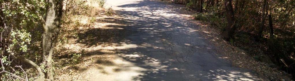
2 CMP Civil Engineering & Land Surveying 167 Capell Valley Road Napa, CA CMPengineering.com EXCEPTION REQUEST LETTER To: Attn: Steve Lederer Date: 4/13/217 Napa County Planning, Building & Environmental Services 1195 Third Street, Suite 21 Napa, CA From: Subject: Remarks: CMP Civil Engineering & Land Surveying Cameron Pridmore PE, PLS 167 Capell Valley Road Napa, CA (77) Exception Request Letter associated with the Grape Vine Lane Commercial Driveway Improvements for the proposed Shed Creek Winery located at 8 Grapevine Lane, APN: , Job# 121 Thank you for taking the time to review the submitted driveway improvement plans. With this letter I am officially requesting an exception to the Napa County Road and Street Standards. According to the Standards, under section 1, objectives: b. Strive to preserve the natural landscape and desirable aesthetic features and c. to encourage the location of roads to minimize disturbance or impacts on wetlands, critical native plant communities or other environmentally sensitive areas. Further the exception is required to minimize grading within the Gordon Valley Creek setback as required in the Napa Stream Setback Ordinance. The specific areas of exception and the associated reasons are listed below. Included at the end of this letter are numbered photographs which show the existing conditions of subject driveway and demonstrate the environmental constraints present. 1. An exception to the 22 foot minimum commercial driveway width from STA +75 to STA 1+33 and STA 2+4 TO STA The driveway will not be widened in this area and the full 22 width cannot be achieved. The reasons for this request are as follows: a. Widening the driveway in these areas to meet the 2 foot width is not environmentally feasible. The existing driveway is surrounded by large heritage oak trees. Widening the driveway would require removing these oak trees. b. The existing driveway in this area is immediately adjacent to Gordon Valley Creek which is a blue line stream. Widening the driveway to the full 22 in this area would require extensive grading to take place within the creek setback. It would also require the destruction of large heritage oaks. All surface improvements in this area are to be constrained to the CMP Civil Engineering & Land Surveying - - Cameron@CMPengineering.com - CMPengineering.com

3 edge of the existing earthen road shoulders, with the exception of the traffic signs shown on the plan. c. To avoid unnecessary erosion of the creek banks which would cause damage to the streams habitat and could cause a flood hazard to downstream residents. 2. An exception to the 22 foot minimum bridge width from STA 7+3 to The existing wide bridge cannot be widened to the full 22 without replacing the footings. It has clear line of site and a space wide enough for two vehicle sot pass on either side of the bridge. Thus we request an exception to the bridge width for the following reasons: a. Replacing the footings will require the complete removal of two large heritage oaks and damage to the root zones of several others. b. Replacing the footing will require extensive grading to take place within the Gordon Valley Stream bed which could damage riparian habitat. c. To avoid unnecessary erosion of the creek banks which would cause damage to the streams habitat and could cause a flood hazard to downstream residents. The Napa County Conservation Regulations support this request and granting the exception would minimize the grading near Gordon Valley Creek and would minimize the impact to the surrounding heritage oaks. The Napa County Road and Street Standards (RSS) also supports this exception given the following RSS objectives: To preserve the natural landscape and desirable aesthetic features while balancing the needs of property owners, to encourage the location of roads to minimize disturbance or impacts on wetlands, critical native plant communities, or other environmentally sensitive areas, to minimize alteration of streams. We have also proposed that a traffic control plan be utilized during large winery events in order to maintain safe passage of vehicular traffic to and from the winery while always maintaining clear passage for emergency vehicles. This traffic control plan has been included with this submittal, please review it for further details. Given the above reasons, granting this exception is the best way to balance human safety while protecting the surrounding environment. We feel the proposed improvements coupled with the traffic control plan meet the same overall practical level of safety as strictly adhering to the RSS would have. Thank you again for taking the time to review this request. Please let me know if you have any further questions or comments. Regards, Cameron Pridmore PE, PLS CMP Civil Engineering & Land Surveying - - Cameron@CMPengineering.com - CMPengineering.com
4 Attachment A Driveway Photos Taken August, 216 CMP Civil Engineering & Land Surveying - - Cameron@CMPengineering.com - CMPengineering.com


5 P 1 P 2 CMP Civil Engineering & Land Surveying - - Cameron@CMPengineering.com - CMPengineering.com


6 P 3 P 4 CMP Civil Engineering & Land Surveying - - Cameron@CMPengineering.com - CMPengineering.com


7 P 5 P 6 CMP Civil Engineering & Land Surveying - - Cameron@CMPengineering.com - CMPengineering.com


8 P 7 P 8 CMP Civil Engineering & Land Surveying - - Cameron@CMPengineering.com - CMPengineering.com


9 P 9 P 1 CMP Civil Engineering & Land Surveying - - Cameron@CMPengineering.com - CMPengineering.com


10 P 11 P 12 CMP Civil Engineering & Land Surveying - - Cameron@CMPengineering.com - CMPengineering.com
11 ABBREVIATIONS GRAPE VINE LANE COMMERCIAL DRIVEWAY IMPROVEMENT PLAN KNOXVILLE RD N LINE LEGEND PROPOSED GRAVEL ROAD IMPROVEMENT PROPOSED AC ROAD IMPROVEMENT FOR THE SHED CREEK WINERY LOCATED AT 8 GRAPEVINE LANE APN: CALISTOGA ANGWIN SAINT HELENA RUTHERFORD YOUNTVILLE CHILES POPE VLY RD HWY 12 SILVERADO TRAIL HWY 29 HWY 128 HWY 121 HWY 12 BERRYESSA HIGHLANDS HWY 128 CIRCLE OAKS NAPA I-8 PREPARED BY: CAMERON PRIDMORE PE, PLS 167 CAPELL VALLEY ROAD CAMERON@CMPENGINEERING.COM CMPENGINEERING.COM PROJECT #: 66 DATE: 5/28/ GORDON VALLEY ROAD SHEET R2 SHEET R3 (E) GRAPE VINE LANE TO BE IMPROVED SHEET R4 SHEET R5 (E) BUILDING TO BE CONVERTED TO (P) WINERY SHEET R6 (E) APPROXIMATE PL (E) RESIDENCE (E) VINEYARD (TYP) VICINITY MAP NTS OWNER BOB MORGAN 346 B ROCKVILLE ROAD FAIRFIELD, CA SHEET INDEX AMERICAN CANYON PROJECT LOCATION CIVIL ENGINEER CMP CIVIL ENGINEERING & LAND SURVEYING CAMERON PRIDMORE PE, PLS 167 CAPELL VALLEY ROAD CAMERON@CMPENGINEERING.COM SHT. # DESCRIPTION R1 TITLE R2 DRIVEWAY IMPROVEMENT PLAN 1 R3 DRIVEWAY IMPROVEMENT PLAN 2 R4 DRIVEWAY IMPROVEMENT PLAN 3 R5 DRIVEWAY IMPROVEMENT PLAN 4 R6 DRIVEWAY IMPROVEMENT PLAN 5 R7 NOTES & DETAILS REV. # DESCRIPTION DATE PROJECT INFO: COUNTY COMMENTS 11/2/ COUNTY COMMENTS 5/26/ COUNTY COMMENTS 9/22/ COUNTY COMMENTS 4/12/17 SHED CREEK WINERY 8 GRAPEVINE LANE APN: TITLE SHEET UNAUTHORIZED CHANGES & USES: THE ENGINEER PREPARING THESE PLANS WILL NOT BE RESPONSIBLE FOR, OR LIABLE FOR, UNAUTHORIZED CHANGES TO OR USES OF THESE PLANS. ALL CHANGES TO THE PLANS MUST BE IN WRITING AND MUST BE APPROVED BY THE DESIGNER OF THESE PLANS. SHEET NAME: HORIZONTAL & VERTICAL DATUM: SHEET: THIS MAP IS BASED ON FIELD SURVEY INFORMATION PERFORMED BY TY HAWKINS LS IN MARCH OF 2. FIELD SURVEY CONTOURS ARE AS FOLLOWS: MAJORS = 5', MINORS = 1'. PROPERTY LINES: THE PROPERTY LINES SHOWN HEREON ARE BASED ON PRELIMINARY SURVEY DATA, AND ARE FOR REFERENCE ONLY. THIS IS NOT A BOUNDARY SURVEY MAP AND SHOULD NOT BE USED AS SUCH. SITE PLAN SCALE 1" = 25' SCALE: 1"=25' Nov 7, 217 R1 OF 7
12 SHEET NAME: DRIVEWAY IMPROVEMENT PLAN 1 PROJECT INFO: SHED CREEK WINERY 8 GRAPEVINE LANE APN: REV. # DESCRIPTION DATE COUNTY COMMENTS 11/2/ COUNTY COMMENTS 5/26/ COUNTY COMMENTS 9/22/ COUNTY COMMENTS 4/12/17 PREPARED BY: CAMERON PRIDMORE PE, PLS 167 CAPELL VALLEY ROAD CAMERON@CMPENGINEERING.COM CMPENGINEERING.COM PROJECT #: 66 DATE: 5/28/ NOTES: 1. GRAPE VINE LANE HAS A VARYING WIDTH AS SHOWN ON THE PLAN. 2. ENVIRONMENTAL CONSTRAINTS BETWEEN STATIONS +75 AND 1+33 AND STATIONS 2+4 AND 9+34 ARE AS FOLLOWS: 1. EXISTING DRIVEWAY FOLLOWS THE TOP OF BANK OF GORDON VALLEY CREEK. EXPANSION OF DRIVEWAY WOULD CAUSE DAMAGE TO THE CREEKS RIPARIAN VEGETATION AND HABITAT. ALSO LARGE OAK TREES LINE BOTH SIDES OF DRIVEWAY IN THIS AREA. DRIVEWAY IMPROVEMENT PLAN 1 DRIVEWAY IMPROVEMENT PROFILE SCALE: 1"=3' 3 6 SCALE: 1"=3' SHEET: R2 OF 7
13 SHEET NAME: DRIVEWAY IMPROVEMENT PLAN 2 PROJECT INFO: SHED CREEK WINERY 8 GRAPEVINE LANE APN: REV. # DESCRIPTION DATE COUNTY COMMENTS 11/2/ COUNTY COMMENTS 5/26/ COUNTY COMMENTS 9/22/ COUNTY COMMENTS 4/12/17 PREPARED BY: CAMERON PRIDMORE PE, PLS 167 CAPELL VALLEY ROAD CAMERON@CMPENGINEERING.COM CMPENGINEERING.COM PROJECT #: 66 DATE: 5/28/ NOTES: 1. BEFORE IMPROVING (E) SHOULDERS, CLEAN UP SHOULDERS REMOVING DEAD VEGETATION AND OTHER DEBRIS LEAVING CLEAN GRAVEL. ADD GRAVEL OVERTOP OF EXISTING ROAD BASE WHERE NECESSARY. 2. GRAPE VINE LANE HAS A VARYING WIDTH AS SHOWN ON THE PLAN. DRIVEWAY IMPROVEMENT PLAN 2 DRIVEWAY IMPROVEMENT PROFILE SCALE: 1"=3' 3 6 SCALE: 1"=3' SHEET: R3 OF 7
14 SHEET NAME: DRIVEWAY IMPROVEMENT PLAN 3 PROJECT INFO: SHED CREEK WINERY 8 GRAPEVINE LANE APN: REV. # DESCRIPTION DATE COUNTY COMMENTS 11/2/ COUNTY COMMENTS 5/26/ COUNTY COMMENTS 9/22/ COUNTY COMMENTS 4/12/17 PREPARED BY: CAMERON PRIDMORE PE, PLS 167 CAPELL VALLEY ROAD CAMERON@CMPENGINEERING.COM CMPENGINEERING.COM PROJECT #: 66 DATE: 5/28/ NOTES: 1. BEFORE IMPROVING (E) SHOULDERS, CLEAN UP SHOULDERS REMOVING DEAD VEGETATION AND OTHER DEBRIS LEAVING CLEAN GRAVEL. ADD GRAVEL OVERTOP OF EXISTING ROAD BASE WHERE NECESSARY. 2. GRAPE VINE LANE HAS A VARYING WIDTH AS SHOWN ON THE PLAN. DRIVEWAY IMPROVEMENT PLAN 3 DRIVEWAY IMPROVEMENT PROFILE SCALE: 1"=3' 3 6 SCALE: 1"=3' SHEET: R4 OF 7
15 SHEET NAME: DRIVEWAY IMPROVEMENT PLAN 4 PROJECT INFO: SHED CREEK WINERY 8 GRAPEVINE LANE APN: REV. # DESCRIPTION DATE COUNTY COMMENTS 11/2/ COUNTY COMMENTS 5/26/ COUNTY COMMENTS 9/22/ COUNTY COMMENTS 4/12/17 PREPARED BY: CAMERON PRIDMORE PE, PLS 167 CAPELL VALLEY ROAD CAMERON@CMPENGINEERING.COM CMPENGINEERING.COM PROJECT #: 66 DATE: 5/28/ NOTES: 1. BEFORE IMPROVING (E) SHOULDERS, CLEAN UP SHOULDERS REMOVING DEAD VEGETATION AND OTHER DEBRIS LEAVING CLEAN GRAVEL. ADD GRAVEL OVERTOP OF EXISTING ROAD BASE WHERE NECESSARY. 2. GRAPE VINE LANE HAS A VARYING WIDTH AS SHOWN ON THE PLAN. DRIVEWAY IMPROVEMENT PLAN 4 DRIVEWAY IMPROVEMENT PROFILE SCALE: 1"=3' 3 6 SCALE: 1"=3' SHEET: R5 OF 7
16 SHEET NAME: DRIVEWAY IMPROVEMENT PLAN 5 PROJECT INFO: SHED CREEK WINERY 8 GRAPEVINE LANE APN: REV. # DESCRIPTION DATE COUNTY COMMENTS 11/2/ COUNTY COMMENTS 5/26/ COUNTY COMMENTS 9/22/ COUNTY COMMENTS 4/12/17 PREPARED BY: CAMERON PRIDMORE PE, PLS 167 CAPELL VALLEY ROAD CAMERON@CMPENGINEERING.COM CMPENGINEERING.COM PROJECT #: 66 DATE: 5/28/ NOTES: 1. BEFORE IMPROVING (E) SHOULDERS, CLEAN UP SHOULDERS REMOVING DEAD VEGETATION AND OTHER DEBRIS LEAVING CLEAN GRAVEL. ADD GRAVEL OVERTOP OF EXISTING ROAD BASE WHERE NECESSARY. 2. GRAPE VINE LANE HAS A VARYING WIDTH AS SHOWN ON THE PLAN. DRIVEWAY IMPROVEMENT PLAN 5 DRIVEWAY IMPROVEMENT PROFILE SCALE: 1"=3' 3 6 SCALE: 1"=3' SHEET: R6 OF 7
17 DRIVEWAY TYPICAL SECTION NOTES - SOFT OR SLIDING AREAS SHALL BE REPAIRED PER SOILS ENGINEERS' RECOMMENDATIONS PRIOR TO CONTINUING CONSTRUCTION. - CONSULT SOILS ENGINEER FOR ADDITIONAL REQUIREMENTS AND CONSULT PROJECT ENGINEER IF EXISTING GRADES PROHIBIT DESIGN SLOPES. - MAINTAIN ' VERTICAL CLEARANCE ABOVE ENTIRE DRIVEWAY WIDTH FOR EMERGENCY VEHICLE ACCESS GENERAL NOTES (P) 1' GRAVEL SHOULDER 3" AC (TYP) 6" CL2 95% REL. DENS. (P) AC MATCH (E) SLOPE VARIES, 22' MAX SEE PLAN VARIES, 2' MAX SEE PLAN (E) AC VARIES C (P) AC MATCH (E) SLOPE (P) 1' GRAVEL SHOULDER 3" AC (TYP) EG 6" CL2 95% REL. DENS. 1. IT IS THE CONTRACTOR'S RESPONSIBILITY TO VERIFY THE LOCATION AND ELEVATION OF ALL EXISTING UTILITIES, PRIOR TO STARTING CONSTRUCTION. THESE PLANS ARE BASED UPON THE BEST INFORMATION AVAILABLE, BUT CAN ONLY BE TAKEN AS APPROXIMATE. 2. ANY UTILITIES THAT MAY HAVE TO BE RELOCATED SHALL BE DONE AT THE OWNERS EXPENSE. 3. PRIOR TO EXCAVATING NEAR ANY P.G. & E., PAC BELL, CITY, COUNTY, OR PRIVATE FACILITIES IT IS THE CONTRACTOR'S RESPONSIBILITY TO CONTACT U.S.A. AT LEAST 2 WORKING DAYS IN ADVANCE AT (8) DAMAGE TO ANY AND ALL UTILITIES BY CONTRACTOR WILL BE REPLACED IN KIND AT OWNERS EXPENSE, AS WELL AS ANY EXISTING PRIVATE OR PUBLIC IMPROVEMENTS OR NATURAL LANDSCAPES SPECIFICALLY DESIGNATED BY OWNER. 5. CONTRACTOR WILL MAINTAIN SAFE CONDITIONS IN THE CONSTRUCTION AREA FOR WORKMEN AND TRAVELING PUBLIC. 6. PRIOR TO THE COMMENCEMENT OF CONSTRUCTION, THE CONTRACTOR SHALL SECURE CONSTRUCTION PERMITS FROM THE NAPA COUNTY PUBLIC WORKS DEPARTMENT, THE NAPA COUNTY CONSERVATION, DEVELOPMENT AND PLANNING DEPARTMENT, AND ANY OTHER JURISDICTIONAL AGENCY AS REQUIRED. OWNER SHALL PAY FOR ALL FEES INCLUDING INSPECTION FEES THEREFORE. 7. ALL STATIONS (ON PLAN) ARE TAKEN ALONG CENTERLINE UNLESS OTHERWISE NOTED ON PLAN AND SHOW MEASUREMENTS IN A HORIZONTAL PLANE. 8. ALL GRADING, SITE PREPARATION, PLACING AND COMPACTING OF FILL SHALL BE DONE ACCORDING TO THESE PLANS, AND NAPA COUNTY REQUIREMENTS. 9. SLOPE PLANTING SHALL BE SPECIFIED BY THE BY OTHER AND IS NOT A PART OF THESE PLANS. 1. ALL CUT AND FILL SLOPES SHALL BE 2:1 OR MORE GENTLE, UNLESS OTHERWISE NOTED 11. ALL ABANDONED UNDERGROUND PIPELINES EXPOSED DURING GRADING SHALL BE REMOVED OR ADEQUATELY PLUGGED. 12. ROUND CUT AND FILL SLOPES TO BLEND IN WITH THE NATURAL GROUND CONTOURS. 13. EROSION CONTROL MEASURES SHALL BE EMPLOYED DURING THE RAINY SEASON AS REQUIRED AND AS SHOWN ON THE APPROVED STORMWATER QUALITY MANAGEMENT PLANS. A PRE-GRADING MEETING MAY BE SCHEDULED AT THE CONTRACTORS REQUEST AT THE SITE 48 (FORTY-EIGHT) HOURS PRIOR TO THE START OF GRADING. THE FOLLOWING PEOPLE SHOULD BE PRESENT: OWNER, GRADING CONTRACTORS, ENGINEER, AND THE COUNTY REPRESENTATIVE. 14. CHANGES TO THIS PLAN DUE TO FIELD CONDITIONS WILL BE MADE ONLY WITH THE APPROVAL OF THE ENGINEER AND THE NAPA COUNTY CONSERVATION, DEVELOPMENT AND PLANNING DEPARTMENT.. ADJACENT PROPERTIES SHALL BE PROTECTED FROM STORM WATERS, MUD, SILT, ETC. 16. THIS PLAN MAY NOT COVER ALL THE SITUATIONS THAT ARISE DURING CONSTRUCTION DUE TO UNANTICIPATED FIELD CONDITIONS. VARIATIONS MAY BE MADE TO THE PLAN IN THE FIELD SUBJECT TO THE APPROVAL OF THE ENGINEER AND THE GOVERNING COUNTY AGENCY. 17. THE CONTRACTOR SHALL BE RESPONSIBLE FOR THE PLACEMENT OF ALL FILLS ACCORDING TO THE PLAN, AND THE PREPARATION OF GROUND TO RECEIVE FILLS, TESTING FOR REQUIRED COMPACTION, STABILITY OF ALL FINISH SLOPES, SOIL EROSION, AND REQUIRED CUT SLOPE SURFACES. PREPARED BY: CAMERON PRIDMORE PE, PLS 167 CAPELL VALLEY ROAD CAMERON@CMPENGINEERING.COM CMPENGINEERING.COM PROJECT #: 66 DATE: 5/28/ 12" SUBBASE TO BE ON COMPETENT MATERIAL APPROVED BY SOILS ENGINEER PRIOR TO PLACEMENT OF BASE MATERIAL. NOTE: PRIOR TO COMPLETION INSURE THAT NO DRAGGING OCCURS AT GRADE TRANSITIONS. 12" SUBBASE TO BE COMPETENT MATERIAL APPROVED BY SOILS ENGINEER PRIOR TO PLACEMENT OF BASE MATERIAL. TYPICAL AC DRIVEWAY IMPROVEMENTS SECTION N.T.S. REV. # DESCRIPTION DATE COUNTY COMMENTS 11/2/ COUNTY COMMENTS 5/26/ COUNTY COMMENTS 9/22/ COUNTY COMMENTS 4/12/17 MAINTENANCE & LIMITATIONS (P) 1' GRAVEL SHOULDER DRIVEWAY TYPICAL SECTION NOTES - SOFT OR SLIDING AREAS SHALL BE REPAIRED PER SOILS ENGINEERS' RECOMMENDATIONS PRIOR TO CONTINUING CONSTRUCTION. - CONSULT SOILS ENGINEER FOR ADDITIONAL REQUIREMENTS AND CONSULT PROJECT ENGINEER IF EXISTING GRADES PROHIBIT DESIGN SLOPES. - MAINTAIN ' VERTICAL CLEARANCE ABOVE ENTIRE DRIVEWAY WIDTH FOR EMERGENCY VEHICLE ACCESS (P) GRAVEL MATCH (E) SLOPE VARIES, TYPICALLY 22', SEE PLAN VARIES, TYPICALLY 2', SEE PLAN (E) PAVED TRAVELED WAY VARIES C MATCH (E) SLOPE (P) 1' GRAVEL SHOULDER EG 1. THE IMPROVEMENTS SHOWN ON THIS PLAN MUST BE MAINTAINED PROPERLY IN ORDER FOR THEM TO FUNCTION PROPERLY. SUCH MAINTENANCE INCLUDES BUT IS NOT LIMITED TO THE FOLLOWING: MAINTAIN ALL BMP'S TO AVOID EXCESS EROSION, MAINTAIN VEGETATIVE COVERAGE ON ALL DISTURBED AREAS, KEEP ALL STORM DRAIN STRUCTURES FREE OF DEBRIS & SEDIMENT. 2. THE EFFECTS OF NORMAL EROSION SUCH AS THOSE DUE TO ENVIRONMENTAL, WEATHER, AND GEOLOGIC CONDITIONS, WILL CONTINUE TO EXIST THROUGHOUT THE PROJECT SITE. THE STABILITY OF EARTH SLOPES AND METHODS OF CONTROLLING THE EFFECTS OF NORMAL EROSION ARE NOT A PART OF THIS PLAN. CONSULT A SOILS ENGINEER FOR THE STABILITY OF EARTH SLOPES AND THE EFFECTS OF NORMAL EROSION. 3. UPON COMPLETION OF ALL PROPOSED IMPROVEMENTS AND EROSION CONTROL MEASURES THE OWNER SHOULD PROVIDE FOR A DETAILED INSPECTION BY THE ENGINEER. THE INSPECTION SHOULD BE PERFORMED BOTH PRIOR TO AND DURING THE FIRST RAIN, TO CHECK THE FUNCTIONALITY OF ALL THE PROPOSED MEASURES & IMPROVEMENTS. IT MAY BE NECESSARY TO MAKE SOME MODIFICATIONS AND/OR REPAIRS TO THESE IMPROVEMENTS IN ORDER TO MAINTAIN A PROPER AND EFFICIENT WORKING SYSTEM. 4. THE PROPERTY OWNER, AND ANY SUBSEQUENT OWNER MUST CLEARLY UNDERSTAND THAT THEY HAVE CHOSEN TO BUILD ON A PROPERTY WITH A REMOTE AND LENGTHY DRIVEWAY FOR ACCESS. THE OWNER NEEDS TO VIGILANTLY REPAIR THE EROSIVE AND ADVERSE EFFECTS OF HEAVY RAINFALL TO THE PROJECT SITE AND THE IMPROVEMENTS SHOWN ON THESE PROJECT PLANS. 5. SIGNIFICANT MAINTENANCE AND UPKEEP COSTS MAY BE ASSOCIATED WITH THIS PROJECT AND SHOULD BE PLANED FOR BY THE OWNER. SEVERE STORMS CAN MOBILIZE SEDIMENTS WHICH CAN IMPAIR THE FUNCTIONALITY OF STORM DRAINAGE DEVICES. IF DRAINAGE DITCHES AND CULVERTS ARE NOT KEPT CLEAR OF SEDIMENTS, EROSIVE & FLOOD DAMAGE TO STRUCTURES AND DRIVEWAY IMPROVEMENTS MAY RESULT. 6. THE DESIGN OF FACILITIES ON THESE PLANS ARE BASED UPON STANDARD ENGINEERING PRACTICES, AND NAPA COUNTY REQUIREMENTS. CHANGES IN TRADITIONAL WEATHER PATTERNS AND RAINFALL INTENSITIES HAVE NOT BEEN PLANNED FOR AND COULD IMPACT THE INTEGRITY OF THE DRIVEWAY AND APPURTENANCES. IT IS SUGGESTED THAT EMERGENCY MEASURES BE PLANNED FOR, AS WELL AS THE COSTS FOR GENERAL MAINTENANCE OF ALL OF THE IMPROVEMENTS SHOWN ON THESE PLANS. PROJECT INFO: SHED CREEK WINERY 8 GRAPEVINE LANE APN: " CL2 95% REL. DENS. 12" SUBBASE TO BE COMPETENT MATERIAL APPROVED BY SOILS ENGINEER PRIOR TO PLACEMENT OF BASE MATERIAL. NOTE: SUBGRADE SHALL BE DRIVEN PRIOR TO COMPLETION TO INSURE THAT NO DRAGGING OCCURS AT GRADE TRANSITIONS. (E) AC ROAD TO BE RESURFACED WITH GRAVEL TYPICAL GRAVEL DRIVEWAY IMPROVEMENTS SECTION N.T.S. SHEET NAME: NOTES & DETAILS SHEET: R7 OF 7
Erosion & Sediment Control Plan Application Form & Checklist
 Erosion & Sediment Control Plan Application Form & Checklist GENERAL INFORMATION Application Date: Project Address: Tax Map / Parcel Number(s): PROPERTY OWNER / DEVELOPER Firm Name: Contact Person: Title:
SECTION 1 CLEARING /GRADING PERMIT APPLICATION:
 PLEASE REFER TO THE CLEARING & GRADING PERMIT CHECKLIST BELOW FOR SUBMITTAL REQUIREMENTS. SECTION 1 CLEARING /GRADING PERMIT APPLICATION: PROJECT ADDRESS (Street, Suite #): Parcel(s) #: Total Site Area
Project phasing plan (if applicable) 12 copies of site plan
 12 copies of site plan") SITE PLAN REVIEW PERMIT APPLICATION City of Grand Haven, 11 N. Sixth Street, Grand Haven, MI 49417 Phone: (616) 847-3490 Fax: (616) 844-2051 Website: www.grandhaven.org 1. Project Information Address/location
SITE PLAN REVIEW PERMIT APPLICATION City of Grand Haven, 11 N. Sixth Street, Grand Haven, MI 49417 Phone: (616) 847-3490 Fax: (616) 844-2051 Website: www.grandhaven.org 1. Project Information Address/location
PLAN SUBMITTER'S CHECKLIST
 Page 1 of 8 PLAN SUBMITTER'S CHECKLIST FOR EROSION AND SEDIMENT CONTROL PLANS Please fill in all blanks and reference the plan sheets/pages where the information may be found, where appropriate, or write
VALLEY COUNTY MINIMUM STANDARDS FOR PRIVATE ROAD DESIGN AND CONSTRUCTION
 MINIMUM STANDARDS FOR PRIVATE ROAD DESIGN AND CONSTRUCTION Adopted November 28, 2005 TABLE OF CONTENTS DEFINITION OF TERMS...II I. DESIGN CRITERIA... 1 A. GENERAL DESIGN CRITERIA... 1 B. ROADWAY CLASSIFICATION...
Gloucester County PLAN SUBMITTER'S CHECKLIST
 Page 1 of 9 Gloucester County PLAN SUBMITTER'S CHECKLIST FOR EROSION AND SEDIMENT CONTROL PLANS Please fill in all blanks and please reference the plan sheets/pages where the information may be found,
PLANNED UNIT DEVELOPMENT & SUBDIVISION STAFF REPORT Date: May 18, 2017
 & PUD-0000102-2017 PLANNED UNIT DEVELOPMENT & SUBDIVISION STAFF REPORT Date: May 18, 2017 NAME SUBDIVISION NAME Dauphin Creek Estates Subdivision Dauphin Creek Estates Subdivision LOCATION CITY COUNCIL
Checklists. Project Name: Location: File Number: Date of Submittal: Reviewer: Date: Applicant: Contact Name: Phone Number:
 Applicant: Contact Name: Phone Number: Email: Project Name: Location: File Number: Date of Submittal: Reviewer: Date: Concept Plan Requirements: I. General Project Information 1. Address or parcel number
Chapter Six: Tree Removal and Erosion Control
 Chapter Six: Tree Removal and Erosion Control Through the combination of canopy and roots, trees help protect and stabilize the land. Their removal requires proper planning and adherence to land-based
WQ-23 MOUNTAINOUS AND STEEP SLOPE SITES
 Greenville County Technical Specification for: WQ-23 MOUNTAINOUS AND STEEP SLOPE SITES 1.0 Mountainous and Steep Slope Sites 1.1 Description The geographic locations of portions of Greenville County are
Zoning Ordinance Chapter 10
 CHAPTER 10 - WASHES SECTION 10.0 GENERAL: A. The purpose of this Ordinance is to establish standards for development in or near Major and Minor Washes as defined in Appendix A Glossary of Terms and Definitions
TO BE COMPLETED BY APPLICANT
 Planning Division #200-2564 Shaughnessy Street Port Coquitlam BC V3C 3G4 Tel 604.927.5442 Fax 604.927.5404 Email planning@portcoquitlam.ca Application for Watercourse Development Permit Watercourse Development
A. Install all temporary erosion control measures (in accordance with MNDOT General Conditions 2573) prior to site disturbance.
 prior to site disturbance.") The language provided in these specifications is meant to serve as a reminder and provide a generic example of the type of language that should be provided in final construction documents. This language
The language provided in these specifications is meant to serve as a reminder and provide a generic example of the type of language that should be provided in final construction documents. This language
Specification and Construction Plans For: South Bethany Landscaping Improvement Plan Contract Number T
 Specification and Construction Plans For: South Bethany Landscaping Improvement Plan Contract Number T201220010 1 INDEX OF SHEETS Sheet Number Description 1 Title Sheet 2 Index of Sheets 3 Overview 4 General
Plan Review Checklist
 Plan Review Checklist FOR EROSION AND SEDIMENT CONTROL PLANS _ Minimum Standards - All applicable Minimum Standards must be addressed. All minimum Standards must be adhered to during the entire project
River Corridor Overlay Zone (RCOZ) Article 5
 Article 5") River Corridor Overlay Zone (RCOZ) Article 5 The site is in one of two designated districts. The first is the CBD (central business district) River District, which recognizes the urban character and unique
River Corridor Overlay Zone (RCOZ) Article 5 The site is in one of two designated districts. The first is the CBD (central business district) River District, which recognizes the urban character and unique
City of Lafayette Study Session Staff Report Design Review Commission
 City of Lafayette Study Session Staff Report Design Review Commission Meeting Date: April 24, 2017 Staff: Payal Bhagat, Senior Planner Subject: HDP18-15 & HDP31-15 Ramesh Patel & Melcor Development (Owners),
SITE PLAN REVIEW APPLICATION AND CHECKLIST
 SITE PLAN REVIEW APPLICATION AND CHECKLIST PROJECT SUMMARY: Project Name: City/ETA Location: City ETA (Application fee & number of copies needed are based on location) Property Location (Legal Description
NAPA COUNTY PUBLIC WORKS Standards & Specifications
 Roadway Design & Construction Manual (Table of Contents) 1. Chapter 1: General Provisions 1.1 Short Title 1.2 Jurisdiction 1.3 Purpose and Effect 1.4 Enactment Authority 1.5 Amendment and Revisions 1.6
Public Information Centre. Welcome
 Transportation Improvements from the Beaver Creek Bridge to the Entrance of Santa s Village District of Muskoka Municipal Class Environmental Assessment Welcome Please sign in Take a comment sheet Staff
Chapter 3 Site Planning and Low Impact Development
 CHAPTER 3 Site Planning and Low Impact Development Chapter 3 Site Planning and Low Impact Development 3.0 Introduction The City of Charleston requires that major residential, large commercial (>1 acre),
A. Install all temporary erosion control measures (in accordance with MNDOT General Conditions 2573) prior to site disturbance.
 prior to site disturbance.") The language provided in these specifications is meant to serve as a reminder and provide a generic example of the type of language that should be provided in final construction documents. This language
The language provided in these specifications is meant to serve as a reminder and provide a generic example of the type of language that should be provided in final construction documents. This language
Project: Developer/Designer: Reviewer: I. Narrative: 1. Project Description: Describes the nature and purpose of the land disturbing activity.
 City of Charlottesville, Virginia Erosion and Sediment Control Plan Review Checklist 610 East Market Street, Charlottesville, VA 22902 Telephone 434-970-3182; Fax 434-970-3359 Project: Developer/Designer:
SECTION 5: REACH RECOMMENDATIONS/MAPS
 SECTION 5: REACH RECOMMENDATIONS/MAPS This section describes areas of concern and provides specific recommendations for each project reach. Locations of stormwater drains were from GIS coverage supplied
Shelbyville, KY Stormwater Best Management Practices. Section 2 EROSION PREVENTION AND SEDIMENT CONTROL PLAN
 Section 2 EROSION PREVENTION AND SEDIMENT CONTROL PLAN 2.1 Requirements The City of Shelbyville, KY will require an Erosion Prevention and Sediment Control (EPSC) Plan for most types of development construction.
Notice of Preparation of an Environmental Impact Report and Scoping Meeting for the Canyon Lane Roadway Improvements Development Project
 of an Environmental Impact Report and Scoping Meeting for the As the Lead Agency, the County of San Mateo (County) will prepare an Environmental Impact Report (EIR) for the (project), and would like your
City of Lafayette Study Session Staff Report Design Review Commission
 ++ City of Lafayette Study Session Staff Report Design Review Commission Meeting Date: January 08, 2018 Staff: Subject: Chris Juram, Planning Technician SS12-17 Miramar Homebuilders, R-20 Zoning: Request
City of Larkspur. Notice of Mitigated Negative Declaration for the 285
 Notice of Mitigated Negative Declaration for the 285 Magnolia Avenue Mixed-Use Project Date: December 2, 2013 Responsible Agency: Project Title: 285 Magnolia Avenue Mixed-Use Project Project Address: 285
Section 3 Non-Structural BMPs
 3.1 Stream Buffers A stream buffer or stream setback is a designated area around a stream, lake, or wetland left in a natural, densely vegetated state so as to protect the receiving water quality and provide
Washington County, Maryland Division of Public Works Policy Manual
 Washington County, Maryland Division of Public Works Policy Manual Subject: Downstream Drainage Easement Category: Land Development Engineering Number: 7-4.1 Date: June 1, 2009 (effective) PURPOSE: The
City of Stoughton Erosion Control Permit Application (effective 2/6/2018)
") City of Stoughton Erosion Control Permit Application (effective 2/6/2018) Incomplete applications will not be accepted Project Name: Address of subject property: Landowner Name(s): Applicant Name: Landowner
City of Stoughton Erosion Control Permit Application (effective 2/6/2018) Incomplete applications will not be accepted Project Name: Address of subject property: Landowner Name(s): Applicant Name: Landowner
City of Mt. Juliet Planning & Zoning Department. Site Plan Checklist. Site plan cklist v1.18
 City of Mt. Juliet Planning & Zoning Department Site Plan Checklist Site Plan approval is required for all specified community facilities, all commercial, industrial, and multi-family residential activities
Florence County Small Commercial Land Disturbance Permit Application
 Florence County Small Commercial Land Disturbance Permit Application Florence County Engineering Division 518 South Irby Street Florence, S.C. 29501 Phone (843) 676-8600 Fax (843) 676-8667 Tax Map Number:
TOWNSHIP OF LOGAN SOIL & FILL IMPORTATION AND PLACEMENT APPLICATION SUBMITTAL CHECKLIST
 TOWNSHIP OF LOGAN SOIL & FILL IMPORTATION AND PLACEMENT APPLICATION SUBMITTAL CHECKLIST Applications: 5 copies of application - Applicant will reproduce the copies at his/her costs. The Township Clerk
MANUAL OF DESIGN, INSTALLATION, AND MAINTENANCE REQUIREMENTS FOR STORMWATER MANAGEMENT PLANS
 MANUAL OF DESIGN, INSTALLATION, AND MAINTENANCE REQUIREMENTS FOR STORMWATER MANAGEMENT PLANS May 2007 SECTION 1 Responsibility of Applicant TABLE OF CONTENTS A. Stormwater Management Plan Required Information
Title 11 Streets and Sidewalks
 Chapter 11.01 - Definitions Title 11 Streets and Sidewalks Low Impact Development (LID) - A stormwater and land use management strategy that strives to mimic predisturbance hydrologic processes of infiltration,
Town of Windham. Planning Department 8 School Road Windham, ME voice fax
 Town of Windham Planning Department 8 School Road Windham, ME 04062 voice 207.864-5960 fax 207.892.1916 MEMO DATE: TO: Staff Review Committee FROM: Amanda Lessard, Planner Cc: Ellen Rathbone, St. Germain
STREAM BUFFERS
 88-415 STREAM BUFFERS 88-415-01 PURPOSE In the Kansas City region and throughout the nation, vegetated stream buffers have been clearly shown to protect stream stability and related infrastructure, improve
Essential Skills: Reading and Interpreting Maps and Plans
 Essential Skills: Reading and Interpreting Maps and Plans Prepared for: NYS Tug Hill Commission Local Government Conference March 31, 2016 Prepared by: Peter G. Vars, P.E. BME ASSOCIATES Stages of Plan
Draft Rhode Island Stormwater Design and Installation Standards Manual
 Draft Rhode Island Stormwater Design and Installation Standards Manual Summary The May 2009 Public Review Draft version of the RI Stormwater Design and Installation Standards Manual consists of approximately
When planning stormwater management facilities, the following principles shall be applied where possible.
 2.0 Principles When planning stormwater management facilities, the following principles shall be applied where possible. 2.0.1 Drainage is a regional phenomenon that does not respect the boundaries between
TENTATIVE MAP CHECKLIST
 Business License 707.648.4357 www.cityofvallejo.net Central Permit Center 555 Santa Clara Street Vallejo CA 94590 Building 707.648.4374 Planning 707.648.4326 TENTATIVE MAP CHECKLIST Public Works/Engineering
Vegetating Disturbed Road & Stream Banks. By Mike Fournier NRCS Resource Conservationist
 Vegetating Disturbed Road & Stream Banks By Mike Fournier NRCS Resource Conservationist Clearly Identify The Problem Project Objectives Clearly Define Objectives Before Work Starts Determine Whether Project
Appendix I. Checklists
 Appendix I Checklists Town of Greenwich Drainage Manual Department of Public Works - Engineering Division Town Hall - 101 Field Point Road, Greenwich, CT 06836-2540 Phone 203-622-7767 - Fax 203-622-7747
Storm Water Basics for Construction Sites Presented by Representatives from the City of Grass Valley and Nevada County
 September 22nd, 2015 3:30PM Sign up at: www.stormwaterawareness.org Workshop is free! Nevada County Contractor s Association 149 Crown Point Ct. Grass Valley, CA 95945 Storm Water Basics for Construction
City of Lafayette Staff Report
 City of Lafayette Staff Report For: By: Design Review Commission Greg Wolff, Senior Planner Meeting Date: April 27, 2015 Subject: SS03-15 Gundi & Peter Younger (Owners), R-40 Zoning: Request for a Study
CARVER COUNTY DIVISION OF PUBLIC WORKS LANDSCAPE POLICY. Adopted by the Carver County Board of Commissioners March 3, 2015
 CARVER COUNTY DIVISION OF PUBLIC WORKS LANDSCAPE POLICY Adopted by the Carver County Board of Commissioners March 3, 2015 Policy Statement Goals It is the goal of Carver County Public Works to provide
SUPPORTING DOCUMENT STORMWATER POLLUTION PREVENTION PLAN (SWPPP) NARRATIVE
 NARRATIVE") SUPPORTING DOCUMENT STORMWATER POLLUTION PREVENTION PLAN (SWPPP) NARRATIVE Please complete this narrative form and submit with your SWPPP drawings. Refer to Kitsap County Stormwater Design Manual Vol.
SUPPORTING DOCUMENT STORMWATER POLLUTION PREVENTION PLAN (SWPPP) NARRATIVE Please complete this narrative form and submit with your SWPPP drawings. Refer to Kitsap County Stormwater Design Manual Vol.
CITY OF TUMWATER 555 ISRAEL RD. SW, TUMWATER, WA (360) (360) (FAX)
 (360) (FAX)") CITY OF TUMWATER 555 ISRAEL RD. SW, TUMWATER, WA 98501 (360) 754-4180 (360) 754-4126 (FAX) Email: cdd@ci.tumwater.wa.us APPENDIX II-C SHORT FORM CONSTRUCTION STORMWATER POLLUTION PREVENTION PLAN (SWPPP)
CITY OF TUMWATER 555 ISRAEL RD. SW, TUMWATER, WA 98501 (360) 754-4180 (360) 754-4126 (FAX) Email: cdd@ci.tumwater.wa.us APPENDIX II-C SHORT FORM CONSTRUCTION STORMWATER POLLUTION PREVENTION PLAN (SWPPP)
PLANNED UNIT DEVELOPMENT STAFF REPORT Date: June 2, 2016
 # 9 ZON2016-01032 PLANNED UNIT DEVELOPMENT STAFF REPORT Date: June 2, 2016 DEVELOPMENT NAME JJT Properties LLC LOCATION 1147 & 1151 East I-65 Service Road South and 1180 Sledge Drive (Southeast corner
COMPLIANCE CHECKLIST HILLSIDE RESIDENTIAL DESIGN GUIDELINES MANUAL
 COMPLIANCE CHECKLIST HILLSIDE RESIDENTIAL DESIGN GUIDELINES MANUAL The following checklist summarizes development guidelines and standards. See the appropriate section for a complete explanation of the
PLANNING APPROVAL STAFF REPORT Date: November 17, 2011
 # 11 ZON2011-02680 PLANNING APPROVAL STAFF REPORT Date: November 17, 2011 NAME LOCATION Alabama Power Company East side of Navco Road 130 ± South of Columbus Avenue CITY COUNCIL DISTRICT District 4 PRESENT
The Town Board of the Town of Vienna, County of Dane, State of Wisconsin, does ordain and adopt as follows.
 ORDINANCE DRIVEWAYS AND CULVERTS NO. 6-5-06 ORDINANCE CONCERNING DRIVEWAY AND CULVERT REQUIREMENTS 1-1-1 Driveway Permits; Culvert Requirements 1-1-2 Driveway and Culvert Location, Design and Construction
Stormwater Regulations & Considerations Morse Study Area. Pam Fortun, P.E. CFM Senior Stormwater Treatment Engineer Engineering Services Division
 Stormwater Regulations & Considerations Morse Study Area Pam Fortun, P.E. CFM Senior Stormwater Treatment Engineer Engineering Services Division Stormwater Regulations Development Considerations Floodplain
STATUS OF REVIEW: ENGINEER WILL COMPLY
 OCTOBER 8, 2013 PROJECT NAME: UHAUL SELF-STORAGE @ S HWY 441 - MAJOR SITE PLAN PROJECT NUMBER: 1999007762 APPLICATION: #11903 Met with staff 10/24/13, DRC on 11/4/13 1. DEPARTMENT: ENGDRN - STORMWATER
ENBRIDGE GAS DISTRIBUTION INC. Proposed Relocation for Ninth Line, Markham and Whitchurch-Stouffville. Environmental Screening Report
 Page 1 of 18 ENBRIDGE GAS DISTRIBUTION INC. Proposed Relocation for Ninth Line, Markham and Whitchurch-Stouffville Environmental Screening Report July 2011 Page 2 of 18 Table of Contents 1.0 INTRODUCTION
Zoning Ordinance Article 3
 Article 3 Natural Resources Protection Section 301 Natural Resources Protection 301.1. Purpose - The following natural resources protection standards are established to protect the public health, safety
STREAM BUFFER PROTECTION AND MANAGEMENT
 ORDINANCE NO. 753 AN ORDINANCE AMENDING THE CODE OF ORDINANCES OF THE CITY OF PLEASANT HILL, IOWA 1998, BY ESTABLISHIING CHAPTER 104, STREAM BUFFER PROTECTION AND MANAGEMENT Be it enacted by the City of
PRELIMINARY STAFF PLANNING REPORT TO THE WALWORTH COUNTY ZONING AGENCY X CONDITIONAL USE
 This report was prepared prior to the public hearing. This report may be supplemented or amended to reflect the review of additional information presented at the public hearing and written material submitted
ST. MARY S SOIL CONSERVATION DISTRICT (SMSCD) AND DPW&T CONCEPT EROSION AND SEDIMENT CONTROL AND STORMWATER MANAGEMENT GUIDELINES AND CHECKLIST
 AND DPW&T CONCEPT EROSION AND SEDIMENT CONTROL AND STORMWATER MANAGEMENT GUIDELINES AND CHECKLIST") St. Mary s Soil Conservation District 26737 Radio Station Way, Suite B Leonardtown, MD 20650 Phone: 301-475-8402 ext. 3 Fax: 301-475-8391 www.stmarysscd.com St. Mary s County Government Department of Public
St. Mary s Soil Conservation District 26737 Radio Station Way, Suite B Leonardtown, MD 20650 Phone: 301-475-8402 ext. 3 Fax: 301-475-8391 www.stmarysscd.com St. Mary s County Government Department of Public
LANDSCAPING. Design. Development of the site shall not unreasonably impair the ability of adjoining properties to utilize solar energy.
 Landscape design is an integral component of Site Planning and Building. The current pattern of walkways, driveways and landscape elements such as fences, hedges, and retaining walls in the neighborhood
F. The following uses in the HR District: attached single-family dwellings, condominiums, and institutional uses; and
 1102 DESIGN REVIEW 1102.01 PURPOSE AND APPLICABILITY Section 1102 is adopted to provide standards, criteria, and procedures under which design review may be approved. Design review is required for: A.
GENERAL INFORMATIONaaaaaaaaaaaaaaaaaaaaaaaaaaaaaaaa
 To: Planning and Zoning Commission From: City Staff Date: November 15, 2016 Re: Case #16026 Raymore Activity Center Site Plan GENERAL INFORMATIONaaaaaaaaaaaaaaaaaaaaaaaaaaaaaaaa Applicant/ Property Owner:
City of Waco Stormwater Management Regulations
 1.0 Applicability: City of Waco Stormwater Management Regulations These regulations apply to all development within the limits of the City of Waco as well as to any subdivisions within the extra territorial
SITE PLAN (REVISED 8/13/18) l. Development Data Table
 l. Development Data Table") SITE PLAN (REVISED 8/13/18) l. Development Data Table a. Site Acreage: 9.25 b. Tax Parcels included in rezoning: #108-081-07 and #108-081-23 c. Existing Zoning (including overlays and vesting): R-3 (see
SITE PLAN (REVISED 8/13/18) l. Development Data Table a. Site Acreage: 9.25 b. Tax Parcels included in rezoning: #108-081-07 and #108-081-23 c. Existing Zoning (including overlays and vesting): R-3 (see
At Your Disposal CUP Amendment, Lot 20, Village Service Commercial, at 128 Bastille Dr. (PLN17-208)
") MEMORANDUM Archuleta County Development Services Planning Department 1122 HWY 84 P. O. Box 1507 Pagosa Springs, Colorado 81147 970-264-1390 Fax 970-264-3338 TO: Archuleta County Planning Commission FROM:
MEMORANDUM Archuleta County Development Services Planning Department 1122 HWY 84 P. O. Box 1507 Pagosa Springs, Colorado 81147 970-264-1390 Fax 970-264-3338 TO: Archuleta County Planning Commission FROM:
Town of Excelsior, Sauk County, Wisconsin DRIVEWAY ORDINANCE
 Town of Excelsior, Sauk County, Wisconsin DRIVEWAY ORDINANCE 1.01 PURPOSE The purpose of this ordinance is to regulate the establishment, construction, improvement, modification or reworking of a driveway
ARTICLE 17 SITE PLAN REVIEW
 ARTICLE 17 SITE PLAN REVIEW 17.01 INTENT AND PURPOSE The intent of this section is to provide for consultation and cooperation between the applicant and the township planning commission so that the applicant
Huntington Stormwater Utility
 Huntington Stormwater Utility Stormwater Management & Sediment and Erosion Control Requirements for Construction Sites Authorized by Huntington City Code Articles: 971, 970, 930, 935, 955, Revised April
New Development Stormwater Guidelines
 New Development Stormwater Guidelines CITY OF MOUNTLAKE TERRACE Table of Contents Introduction... 2 Ecology s Minimum Requirements for stormwater management... 2 Description of the 9 Minimum Requirements...
CITY OF PORTSMOUTH PLANNING DEPARTMENT. MEMORANDUM To: From:
 CITY OF PORTSMOUTH PLANNING DEPARTMENT MEMORANDUM To: From: Subject: Date: Planning Board Juliet T.H. Walker, Planning Director Jillian Harris, Planner 1 Staff Recommendations for the August 23, 2018 Planning
SMALL PROJECTS SIMPLIFIED APPROACH
 SMALL PROJECT APPLICATION AND STORMWATER MANAGEMENT DESIGN ASSISTANCE MANUAL FOR SMALL PROJECTS IN FULTON TOWNSHIP LANCASTER COUNTY, PENNSYLVANIA SMALL PROJECTS SIMPLIFIED APPROACH Prepared By: Light-Heigel
Pittsburgh District Pittsburgh, PA Notice No Closing Date: May 29, 2015
 Public Notice U.S. Army Corps In Reply Refer to US Army Corps of Engineers, Pittsburgh District of Engineers Notice No. below 1000 Liberty Avenue Pittsburgh District Pittsburgh, PA 15222-4186 Application
Construction and Landscaping on Public Property
 Construction and Landscaping on Public Property City of Manhattan Beach Community Development Department 1400 Highland Avenue 310-802-5504 www.citymb.info January, 2004 Construction and Landscaping on
Major Subdivision Sketch Plan Checklist
 This checklist provides specific requirements that are apart of the Sketch process. The entire process is described by the Huntersville Subdivision Review Process which details all the submittal and resubmittal
BREWSTER SR173 PROPOSED: OKANOGAN RIVER PADDLERS CAMPGROUND WATERBODY: OKANOGAN RIVER NEAR: BREWSTER COUNTY: OKANOGAN STATE: WASHINGTON
 OKANOGAN RIVER PROJECT LOCATION SR53 COLUMBIA RIVER SR73 METHOW RIVER PATEROS SR7 SR7 BRIDGEPORT VICINITY MAP NEAR: VICINITY 2 GEBBERS FARMS INC APN 302570024 STATE HWY 7 DOUGLAS CO. PUD NO. APN 302570037
WELCOME! 8 8:30 6: TH STREET IMPROVEMENTS. Open House. Presentation & Q&A
 WELCOME! 168 TH STREET IMPROVEMENTS 6:30 Open House 7 8 Presentation & Q&A 8 8:30 Open House WELCOME Todd Pfitzer City of Omaha Engineer Bob Stubbe City of Omaha Public Works Director Jon Meyer Project
Presentation to Parks and Open Space Advisory. Committee September 22, 2016
 Flood Planning & Preliminary Design Services for South St. Vrain Creek Restoration at Hall Ranch Presentation to Parks and Open Space Advisory Prepared for: Boulder County, Colorado Committee September
Information for File # JTF
 Information for File # 2013-04665-JTF Applicant Corps Contact Enbridge Energy, Limited Partnership Josh Fitzpatrick Address 1554 Highway 2, Suite 2, Two Harbors, MN 55616 E-Mail joshua.t.fitzpatrick@usace.army.mil
Department of Agriculture. Conservation Service. United States. Natural Resources REVISED 8/26/16
 GENERAL NOTES: SYMBOL LEGEND 1. All work shall comply with the constriction specifications, drawings, project-specific quality assurance plan and other contract requirements. 2. All notes on the drawings
Community LID Workgroup Issue Paper #6
 Community LID Workgroup Issue Paper #6 Topic: Hard and Impervious Surface Coverage Limits Objective: Minimize the amount of hard and impervious surfaces in developments to allow more stormwater to infiltrate
Butte Creek Canyon. The New Road Built in April of 2015 by Signalized Intersection West, LLC. Presentation slides from December 2015 through June 2016
 Butte Creek Canyon The New Road Built in April of 2015 by Signalized Intersection West, LLC Presentation slides from December 2015 through June 2016 1 Dry Creek Bed: Because there is no culvert, rainwater
Riparian Buffer on the Bushkill Creek. Policies
 Riparian Buffer on the Bushkill Creek Riparian buffers provide numerous benefits to landowners and the community by protecting groundwater recharge areas, providing flood control, providing stormwater
Plat Requirements CHECKLIST FOR SITE PLAN REVIEW
 This checklist is to be used as a guide for complying with the Town of Hollis Site Plan Regulations. It is to be used for each individual site plan review application submitted. Applicants are encouraged
APPENDIX A SIMPLIFIED APPROACH TO STORMWATER MANAGEMENT FOR SMALL PROJECTS. In West Sadsbury Township, Chester County, Pennsylvania
 APPENDIX A SIMPLIFIED APPROACH TO STORMWATER MANAGEMENT FOR SMALL PROJECTS In West Sadsbury Township, Chester County, Pennsylvania TABLE OF CONTENTS I. Introduction 3 II. Importance of Stormwater Management
Chagrin River Watershed Partners, Inc. Local Regulations. Amy H. Brennan (440)
") Chagrin River Watershed Partners, Inc. Local Regulations Amy H. Brennan (440) 975-3870 www.crwp.org abrennan@crwp.org July 9, 2013 Applicable Zoning and Building Codes Erosion and Sediment Control Grading
Chagrin River Watershed Partners, Inc. Local Regulations Amy H. Brennan (440) 975-3870 www.crwp.org abrennan@crwp.org July 9, 2013 Applicable Zoning and Building Codes Erosion and Sediment Control Grading
Storm Water Quality and Shoreline Restoration Improvements - Grant Funding Request City of Mound Carlson Park Bolton & Menk Project No.
 September 15, 2016 Brett Eidem Cost Share Grant Administrator Minnehaha Creek Watershed District 15320 Minnetonka Boulevard Minnetonka, MN 55345 RE: Storm Water Quality and Shoreline Restoration Improvements
STORM WATER MANAGEMENT PLAN APPLICATION Manheim Borough
 STORM WATER MANAGEMENT PLAN APPLICATION Manheim Borough DATE Application is hereby made to Manheim Borough for the issuance of a Storm Water Management Plan approval pursuant to the Manheim Borough Storm
Town of Vershire Road Erosion Inventory Report
 Town of Vershire Road Erosion Inventory Report Taylor Valley Road. Photo taken by TRORC staff. Prepared by: 128 King Farm Road Woodstock, VT 05091 Inventory and report funded by the Vermont Agency of Transportation
ABBREVIATIONS: TABLE OF CONTENTS: REFERENCE MATERIALS: CITY OF SEATTLE COMBINED SEWER OVERFLOW GALLONS PER MINUTE POLYVINYL CHLORIDE SQUARE FEET
 TABLE OF CONTENTS: ABBREVIATIONS: SHEET NO. A SHEET DESCRIPTION REFERENCE SHEETS TITLE SHEET COS CSO GPM PVC SF CITY OF SEATTLE COMBINED SEWER OVERFLOW GALLONS PER MINUTE POLYVINYL CHLORIDE SQUARE FEET
A. Regional Detention Requirements
 I. GENERAL DESIGN GUIDELINES A. Full-spectrum detention is provided for all new development, redevelopment or expansion of a site to provide for water quality and flood control detention. B. Detention
Weston s Wetlands, Stormwater, & Open Space
 Weston s Wetlands, Stormwater, & Open Space Weston s Wetlands, Stormwater, & Open Space Conservation Commission Role and Responsibilities Laws that protect wetlands What residents can do to protect wetlands
5. LOW IMPACT DEVELOPMENT DESIGN STANDARDS
 5. LOW IMPACT DEVELOPMENT DESIGN STANDARDS Low Impact Development (LID) requires a shift in stormwater management away from conveying runoff to a small number of downstream points through hydraulically
UNIVERSITY OF NORTHERN IOWA
 UNIVERSITY OF NORTHERN IOWA Municipal Separate Storm Sewer System September 2008 Report Permit Number 07-09-0-04 August 2008 Prepared by: University of Northern Iowa Environmental Health and Safety Office
Pavement Removal Fact Sheet
 Rushern L. Baker, III County Executive Pavement Removal Fact Sheet What is pavement removal? Pavement removal is the replacement of impervious surfaces, such as asphalt and concrete, with grass or native
CHAPTER 26 LANDSCAPING (Chapter added in its entirety 05-08)
") CHAPTER 26 LANDSCAPING (Chapter added in its entirety 05-08) 26.01 DESCRIPTION AND PURPOSE. Landscaping is an important element of the use, development and preservation of land, and a significant factor
CHAPTER 26 LANDSCAPING (Chapter added in its entirety 05-08) 26.01 DESCRIPTION AND PURPOSE. Landscaping is an important element of the use, development and preservation of land, and a significant factor
3. Are there any projects exempt from the definition of Regulated Projects?
 STORMWATER REQUIREMENTS: OVERVIEW OF PROVISION C.3 Background: On October 14, 2009, the Regional Water Quality Control Board, San Francisco Bay Region, issued a municipal regional stormwater permit (MRP)
High Point Community: Site Drainage Technical Standards. High Point Community Site Drainage Technical Standards
 High Point Community Site Drainage Technical Standards Prepared by SvR Design Company for High Point Community Seattle, Washington 5/2004 Revised 12/2006 101 Acknowledgements: for innovative development
CHECKLIST FOR PHASE II DRAINAGE REPORT
 I. COVER SHEET CHECKLIST FOR PHASE II DRAINAGE REPORT A. Name of Project B. Address C. Owner D. Developer E. Engineer F. Submittal date and revision dates as applicable II. GENERAL LOCATION AND DESCRIPTION
Urban Conservation Practice Physical Effects ESTABLISHMENT, GROWTH, AND HARVEST NUTRIENT MANAGEMENT
 NOT WELL 800 - Urban Stormwater Wetlands A constructed system of shallow pools that create growing conditions for wetland plants to lessen the impacts of stormwater quality and quantity in urban areas.