Linby Neighbourhood Plan Masterplan Safeguarded Land Top Wighay Farm March Linby Neighbourhood Development Plan Masterplan 1
|
|
|
- Hubert Russell
- 5 years ago
- Views:
Transcription

1 Linby Neighbourhood Plan Masterplan Safeguarded Land Top Wighay Farm March 2017 Linby Neighbourhood Development Plan Masterplan 1

2 Linby Neighbourhood Development Plan Masterplan 2
3 Contents: Section 1: 1.1 Introduction 1.2 About this Report Section 2: 2.1 Baseline Data 2.2 Context SWOT Analysis 2.3 Emerging Neighbourhood Plan Vision 2.4 Local Planning Policy 2.5 Safeguarded Land 2.6 Site Analysis Section 3: 3.1 Review of LPA Masterplan 3.2 Concept Masterplan for Safeguarded Land 3.3 Option Option 2 Section 4: 4.1 Next Steps 4.2 Other Recommendations 4.3 List of Evidence and Sources Linby Neighbourhood Development Plan Masterplan 3
4 Section 1 Linby Neighbourhood Development Plan Masterplan 4
5 1.1 Introduction Through the Department of Communities and Local Government (DCLG), Neighbourhood Planning Programme, Urban Vision Enterprise CIC has been commissioned by Locality to produce a Masterplan document for Linby Neighbourhood Plan Steering Group. The Masterplan aims to review the existing evidence base and inform the potential development of land identified as Safeguarded Land at Top Wighay Farm. Inform future development providing a framework for the Linby Neighbourhood Plan Steering Group to produce a Development Brief. The Masterplan aims to provide guidance on: The mix of development and potential land uses; Identify opportunities to maximise the rural characteristics and enable the community to further enjoy areas identified with landscape designations; Provide enhanced linkages with exiting connections and explore opportunity for new; Linby Neighbourhood Development Plan Masterplan 5
6 1.2 About this Report Neighbourhood Plan Steering Group and incorporate the comments; To prepare and produce this report the following methodology was followed informing this document: Issue final report. Collate data and review exiting evidence base, including liaising with Gedling Borough Council; Understanding and setting the planning context. Review the Development Brief for the allocated land; Undertake a site visit and record land uses; Prepare an urban design analysis; Engage with landowners; Work in partnership with the Linby Neighbourhood Plan Steering Group to inform the Masterplan document; Produce a draft report to be reviewed by the Linby Linby Neighbourhood Development Plan Masterplan 6
7 Section 2 Linby Neighbourhood Development Plan Masterplan 7
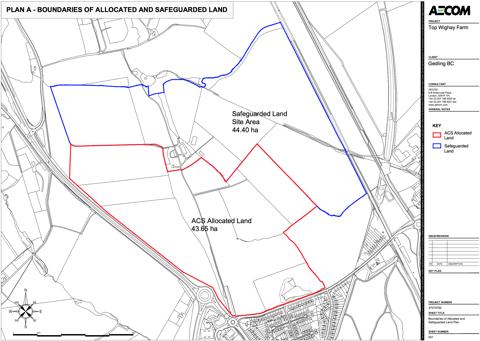
8 2.1 Baseline Data Population Size 232 (2011 Census) Size of Linby Parish 370 ha Average Rainfall per annum 709.4mm Average High Temperature per annum 13.4 c 96m (315 ft) above sea level Average Low Temperature per annum 6.1 c 8.7 Miles from Nottingham Average Number of Hours of Sunshine per annum Miles from Hucknall Population Density: 0.6 hectare (Linby Parish) 9.5 per ha (Gedling) 3.9 Miles from M1 Junction 27 Average Download speed 8.5mbs 10 Landscape Designations in the parish 27 Listed Buildings or Items in the Parish & 2 Scheduled Ancient Monuments Top Wighay Farm Safeguarded Land Area 46.8ha Linby Neighbourhood Development Plan Masterplan 8
9 2.2 Context SWOT Analysis As part of the methodology this report is informed and based upon the identified needs and issues of the community. Urban Vision Enterprise CIC consulted with the Linby Neighbourhood Plan Steering Group and produced the following group SWOT analysis of the Safeguarded Land. This provides a context that will inform the Masterplan and next steps, addressing the following points identified: Strengths Proximity to Nottingham and Hucknall and good links to the M1 Could be developed in phases Strong visual identity and character of Linby village If undeveloped it remains as open countryside Weaknesses Volume of traffic and significant increase Speed of traffic Pedestrian safety School traffic Car parking Traffic noise Inadequate public transport Poor broadband Nowhere to play for children Access to health facilities Air pollution General lack of community services and infrastructure to support residents of new homes in particular schools, health services etc. Opportunities Better housing stock may result in an improved Hucknall High Street and local bars and restaurants. Identify suitable measures to manage/calm traffic New developments to respect and reflect the characteristics of the area Create a mix of housing types family homes and bungalows Improve infrastructure and facilities Land adjacent to the existing railway making new connections or extending the tram in the future Threats Extra traffic to and from Top Wighay and other developments in and around Hucknall Lack of HGV enforcement Out of character developments Urbanising a rural area Pressure on services and infrastructure Unsympathetic development detracting from the character of Linby Linby Neighbourhood Development Plan Masterplan 9
10 2.3 Emerging Neighbourhood Plan Vision The emerging Linby Neighbourhood Plan has a draft vision and set of aims. These are based on what makes the parish and the main village of Linby so distinctive, including its rural setting, its strong sense of place, the historic core and Conservation Area of Linby village. The emerging Neighbourhood Plan explores and identifies the issues and challenges that the parish faces, including significant residential development in a small rural parish, infrastructure provisions and capacity, protecting and enhancing the Conservation Area and distinct local character. The draft vision sets a clear aspiration with key objectives to: Protect and enhance the rural and historic character of the existing village. Where change is embraced and there is a cohesive, integrated community with access to high level of good community services and facilities. To deliver sustainable infrastructure, accessible transport and high environmental standards. 2.4 Local Planning Policy The Greater Nottingham Aligned Core Strategy Part 1 Local Plan, was adopted in September 2014 and includes the saved policies from the Gedling Borough Local Plan Adopted The emerging Gedling Borough Council Local Plan Document, Part 2 Local Plan, consultation draft May 2016, is likely to be adopted in July Ensuring that planned development delivers high quality homes and employment opportunities. Linby Neighbourhood Development Plan Masterplan 10
11 The Greater Nottingham Aligned Core Strategy Part 1 Local Plan describes the opportunity and land uses on the allocated land at Top Wighay Farm as: New employment within large residential development at Top Wighay Farm will help to meet sustainable objectives in reducing the need to travel, and will also provide new opportunities for existing residents. In respect of future development the core strategy clearly states that settlements including Linby have only been allocated small scale development to meet local needs. This is an important factor to this report as it goes on to state that Local need will be defined in the part 2 Local Plan, and may include exception sites, small scale infill, and rounding off of settlement boundaries. (para , Aligned Core Strategies Part 1 Local Plan, Greater Nottingham, Adopted September 2014 ) (para , Aligned Core Strategies Part 1 Local Plan, Greater Nottingham, Adopted September 2014 ) It also identified that the allocated land provides an opportunity to create new facilities such as a school and community services that will improve the infrastructure for the exiting and future community. The core strategy also acknowledges that Linby Village which is adjacent to the allocated and Safeguarded Land is one of six rural villages with a strong sense of heritage, and is designated as a Conservation Area. This is a critical aspect that the Masterplan for the safeguarded land must consider. This is important when considering the future development of the rural parish and the settlement growth within the village of Linby. The emerging Local Plan Part 2 indicates that the projected growth for Linby Parish includes a mixture of strategic sites (Top Wighay and Land North of Papplewick Lane) and infill development. The emerging Local Plan identifies two key target figures relating to housing density at 30 and 20 units per hectare for some rural Linby Neighbourhood Development Plan Masterplan 11


12 villages. However, It does make clear that in Linby, the future density of sites could be less than 20 units per hectare with evidence to reflect the rural character. This density principle is more appropriate to rural settings and could be applied in the Masterplan for the Safeguarded Land. The emerging Local Plan also states that: Of the three sites identified as being safeguarded for future development Top Wighay Farm and Moor Road may be suitable for development in their entirety subject to a detailed assessment of the site through a review of the local plan and a subsequent planning application. (Para 6.6.5, Local Plan Document Publication Draft, Part 2 Plan, May 2016, Gedling Borough Council) Linby Neighbourhood Development Plan Masterplan 12
13 2.5 Safeguarded Land (Pg 52, Local Plan Document Publication Draft, Part 2 Plan, May 2016, Gedling Borough Council) The core strategy identifies the Top Wighay Farm as a zoned mixture of Allocated Land, Safeguarded Land and Green Belt. Safeguarded Land is defined as: It identified Top Wighay Farm as one of three Safeguarded Land sites with an area of 46.8ha. Land outside of the main built up areas of Nottingham and settlements specifically excluded from Green Belt but safeguarded from development unless a future plan is adopted that allocates it for development. (pg273, Aligned Core Strategies Part 1 Local Plan, Greater Nottingham, Adopted September 2014 ) Policy LPD 16 of the emerging Local Plan states that: The following land is removed from the Green Belt and designated as Safeguarded Land and protected from development in order to meet longer term development needs. Linby Neighbourhood Development Plan Masterplan 13
 (Linby Parish Council, http://www.linby.org.uk/perch/resources/linby-parish-boundarymap.")
14 Neighbourhood Plan Area and Safeguarded Land (pg46, Top Wighay Farm Development Brief Supplementary Planning Document, Gedling Borough Council, February 2017) (Linby Parish Council, Linby Neighbourhood Development Plan Masterplan 14

15 2.6 Site Analysis The plan illustrated here captures the findings from a site visit to understand the current site context and the wider character setting. In addition to this analysis further key factors have been identified in greater detail. KEY: Direction of the fall of land Landmarks Key Views Noise from road Higher ground Routes/paths Embankment Linby Neighbourhood Development Plan Masterplan 15


16 Site Analysis (pg46, Top Wighay Farm Development Brief Supplementary Planning Document, Gedling Borough Council, February 2017) Linby Neighbourhood Development Plan Masterplan 16
17 Land Uses The Safeguarded Land is predominantly Grade 3 agricultural land with some Grade 2, bounded by mature hedgerows. On the southern boundary Top Wighay Farm occupies a central location, surrounded by the undulating agricultural land. The land uses identified for the adjacent site of the Allocated Land include, employment; residential; open space; a local centre (shops and services) and community infrastructure such as new education facilities (Primary school). These uses have been zoned in the Top Wighay Farm Development Brief Supplementary Planning Document. The proposed land uses plan shown in the concept layout indicate that the Safeguarded Land which is located to the north of the Allocated Land would border predominantly residential development with a central open space linking the two areas and providing a green buffer around Top Wighay Farm which is located within the Safeguarded Land. Communication Infrastructure The IDP in the core strategy summarises the constraints of the allocated land. It would be reasonable to assume given the proximity to the Safeguarded Land that these would be similar for this area also. IT- No abnormal requirements. (pg 187, Aligned Core Strategies Part 1 Local Plan, Greater Nottingham, Adopted September 2014 ) However, this is not a true reflection as illustrated in the baseline data earlier in this section the current average download speed is 8.5Mbs. Enhancements to broadband provision and ICT infrastructure could be pursued with partners. According to the government s Broad Band UK office (BDUK) the Government s national target is for 95% of people in each local authority area to be put within reach of a fixed line superfast broadband service by 2017, which has for the most part been described as a service that offers speeds of greater than 24 Megabits per second (i.e. 24Mbps+, or 25Mbps). It could be made a criteria in the Masterplan and written as a policy for the Neighbourhood Plan. Linby Neighbourhood Development Plan Masterplan 17
18 Infrastructure Currently there is no or limited infrastructure provision on the land given its current land use of agriculture. Services are on site serving a single property of Top Wighay Farm. However with the recent Strata Homes development in the Allocated Land the infrastructure provision and accessibility will be significantly enhanced by this development and the forthcoming phased developments in the area. Key Views and Vistas Currently the site is not publically accessible. However a recent neighbouring development at Strata Homes provides an opportunity to identify potential key views and vistas. There is a visual connection with the historic village of Linby, the tower of St Michaels Church is visible from the lower south-eastern edge of the Safeguarded Land. Framed views could be created through the urban form to ensure the visual connection is maintained. Other key views are to higher areas of land with substantial tree cover, which are located outside of the area. The raised railway line that occupies the eastern boundary prevents any further views to Linby village or the open land beyond. This physical barrier provides definition between the Conservation Area of Linby and any new development in the future. Linby Village The historic village of Linby is located to the east of the Safeguarded Land, screened from the site by the existing railway line and the Linby Trail. Any future development should demonstrate how it could reflect and enhance the character of the parish, respecting the setting and relationship to the neighbouring village. Linby has a very distinct local character with a limited materials pallet. Predominantly the building materials consist of the Linby Yellow Stone and Pantile roofs, with wooden window frames. Further information about the character of Linby can be found in the Heritage and Character Assessment, November 2016 at: Linby Neighbourhood Development Plan Masterplan 18
19 Section 3 Linby Neighbourhood Development Plan Masterplan 19
20 3.1 Review of LPA Masterplan Gedling Borough Council adopted the Top Wighay Farm Development Brief in February 2017 to ensure that as a key development site it prepared to add detail to the relevant policies in the Aligned Core Strategies Part 1 Local Plan, Greater Nottingham, Adopted September 2014 (ACS). The Development Brief identifies and makes clear the three types of land within the area as Allocated Land, Safeguarded Land and Green Belt. It goes on to prepare in detail a concept Masterplan for the Allocated Land whilst making reference and showing linkages to the Safeguarded Land. The Development Brief makes clear that any future development: Of additional housing on or part of the Safeguarded Land, will need to be addressed on a cumulative basis. (pg7,top Wighay Farm Development Brief, Supplementary Planning Document, Gedling Borough Council, February 2017) It also highlights that this land may be used for the provision of housing or other land uses. This provides an opportunity for the future where the community can review the need through the Neighbourhood Plan process and prepare a Development Brief to guide the types and mix of uses appropriate, complementing the vision of the development brief for the allocated land and ensuring a holistic and joined up approach to delivery. Another critical aspect from the evidence of the development brief is that it identifies that: There are no existing utility services, community facilities or drainage provision within the site that would support the level of demand anticipated to arise from proposed development. (pg8,top Wighay Farm Development Brief, Supplementary Planning Document, Gedling Borough Council, February 2017) This is a key consideration as should the Safeguarded Land come forward for development in the future to a certain extent these issues may have been partially addressed. However this Linby Neighbourhood Development Plan Masterplan 20
21 also provides an opportunity through the neighbourhood plan to prepare a policy on Sustainable Urban Drainage Systems (SUDs) perhaps as part of a wider design policy. The development brief goes on to identify and explore the site opportunities and constraints, which to a greater or lesser degree are all applicable to the Safeguarded Land and should be considered in addition to those raised in Section 4 of this report. These were: Climate Change: Issues of drainage, considerations for delivering a low carbon energy associated infrastructure, potential for solar fields etc.. Air Quality: Apply LPA guidance on air quality and mitigation. Landscape: Highlights that the site is within the Greenwood Community Forest and is surrounded to the north, east and west by Green Belt. Highlights potential of visual impact of development on open undulating agricultural land. Requests a landscape biodiversity strategy. Nature Conservation: Opportunity to enhance ecological resources, ecological assessments required with planning applications, acknowledges the two Local Wildlife Sites and acknowledges that no further development can take place on these without these adversely impacting on them, importance of hedgerows and retention of those on site. Archaeology and Heritage: Acknowledges the proximity to the Linby Conservation Area and listed buildings and structures. Further archaeological investigations should be made and a detailed heritage assessment as part of the EIA (Environmental Impact Assessment). Built Environment: The brief identifies the Bulwell Stone as the main building material in Linby, describes and highlights the character of Linby Village and the Conservation Area. Geo-environmental Considerations: Phased risk based contamination assessment to be undertaken, former British Coal site, both the Allocated and Linby Neighbourhood Development Plan Masterplan 21
22 Safeguarded Land have experienced land subsidence from underground coal mining, the Environment Agency have advised there is a small area of sensitive groundwater located to the north-west of the are to be protected. The development brief also provides a series of concept plans that have been used to shape the options presented in this report. There are two key significant concept plans used and these are Plan B-Concept Layout Plan, which provides an idea of proposed land uses and location, key routes, green spaces and linkages; Plan F-Density Plan, indicates the location of density of development. On a scale between 30, 40 and 60 dwellings per hectare it allocates sites with varying density. However most critically it locates the lower density (30 dph) on the boundary to the Safeguarded Land. This is significant to this report which explores the option of densities of 30dph and 20dph as identified as options in the emerging Local Plan. To read more about the development brief follow this link: nationlibrary/ex-42%20final%20version%20for%20cabinet%20- %20Feb% pdf Linby Neighbourhood Development Plan Masterplan 22
 Linby Neighbourhood Development Plan Masterplan")
23 (pg47,top Wighay Farm Development Brief, Supplementary Planning Document, Gedling Borough Council, February 2017) Linby Neighbourhood Development Plan Masterplan 23
 Linby Neighbourhood Development Plan Masterplan")
24 (pg51,top Wighay Farm Development Brief, Supplementary Planning Document, Gedling Borough Council, February 2017) Linby Neighbourhood Development Plan Masterplan 24
25 3.2 Concept Masterplan for Safeguarded Land This section considers the preparation, which is based upon the identified aims of the emerging Linby Neighbourhood Plan and creates a strategic framework to be developed into a development brief, included in the neighbourhood plan. The process and outputs of this masterplan are: Stage 1 Identify the aims and objectives: Set by the vision and aims of the emerging Linby Neighbourhood Plan (Section 2 of this report). Stage 2 Outline the Strategic Framework: Collate and analyse the evidence base. Undertake an urban design site analysis (Section 2 of this report). Stage 3 Develop the Masterplan Concept: Ideas and principles to be addressed in the development brief, include a couple of options based on findings (Section 3 of this report). Stage 4 Set the Next Steps and Key Recommendations: Develop a strategic set of recommendations that can be delivered through the Neighbourhood Plan process to meet the needs of the community and original aims of the report (Section 4 of this report). Stage 5 Wider Consultation: Following the development of the concept Masterplan, develop the approach informed by stakeholder engagement. This includes landowners, local authority, wider community and other stakeholders such as Strata Homes, who are currently developing on the Allocated Land. Linby Neighbourhood Development Plan Masterplan 25

26 Concept Masterplan for Safeguarded Land KEY: Sunpath Landmarks Key Views Noise from road Higher ground Routes/paths Embankment Landscape Transition Zone Open Space Linby Neighbourhood Development Plan Masterplan 26

 that provide a natural landscape feature in an urban setting.")


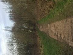
27 Design Principles and Features Footpaths and Connections Water in the Landscape The use of water and its integration in the landscape is a significant feature of Linby Village and local area. Adjacent to the site there are small streams and ponds that could be linked to or an opportunity to create Sustainable Urban Drainage systems (SUDs) that provide a natural landscape feature in an urban setting. The Safeguarded land is located parallel to the Linby Trail. Any future development of this land should make direct connections providing new linkages to an established multiuser route. The image above taken on the Linby Trail shows clearly that it is used by horses, cyclists and pedestrians. Any future development should also seek to create new pedestrian routes to new services and community spaces developed and new connections to Linby village. Linby Neighbourhood Development Plan Masterplan 27


28 Natural and Built Assets Distinct Building Materials The Safeguarded land is adjacent to a SSSI and Linby Conservation Area. Any development must demonstrate how it preserves and enhances these characteristics and the wider character of Linby parish as a rural settlement. The predominant and common building materials found in Linby. The high quality public realm is enhanced through the use of a materials pallet appropriate to the conservation setting and character of the rural village. Predominantly the building materials consist of the Linby Yellow Stone and Pantile roofs, with wooden window frames. The use of UPVC windows is limited and when used within the conservation area detracts from the character and appearance. Linby Neighbourhood Development Plan Masterplan 28
29 3.3 Option 1 Housing Density: Apply the lower density-housing figure in the emerging Local Plan of 20 units per hectare. Define the location and role of open space. Create a business start-up centre. Phased development using natural separation and extending Allocated Land Green Space link to provide separation between phases. Improved linkages and permeability between the Allocated Land and the Safeguarded Land. Create new and better linkages with the Linby Trail. Enhance pedestrian and cycle routes. Extend the tram link to provide a new stop on the network. Fields in Trust Guidance: Based on the total site area of 44.40ha assuming a density of 20 dwellings per hectare (dph) the provision should be: 1) Playing Pitches: 2.56ha 2) Outdoor Sports: 3.41ha 3) Equipped/Designated Play Areas: 0.53ha 4) Other Outdoor Provision: 0.64ha Linby Neighbourhood Development Plan Masterplan 29
30 3.4 Option 2 Housing Density: Apply the density-housing figure in the emerging Local Plan of 30 units per hectare. Define the location and role of open space. Enhance pedestrian and cycle routes. Maximising the enhancement of SINC s and incorporating into future development. Integrate Sustainable Urban Drainage Systems (SUDS) to link with existing waterways. Integrate the Traffic in Villages design options to the residential development. Provide a Landscape Transition Zone between the built form and extension to the open countryside. Develop stronger visual links with Linby Village, frame views and vistas to provide interest and create a legible development. Consider the wider community infrastructure needs including health, transport, connectivity. Fields in Trust Guidance: Based on the total site area of 44.40ha assuming a density of 30 dwellings per hectare (dph) the provision should be: 1) Playing Pitches: 3.8ha 2) Outdoor Sports: 5.11ha 3) Equipped/Designated Play Areas: 0.80ha 4) Other Outdoor Provision: 0.96ha Linby Neighbourhood Development Plan Masterplan 30
31 Section 4 Linby Neighbourhood Development Plan Masterplan 31
32 4.1 Next Steps Green Space Allocations Through the site analysis and reviewing the existing Masterplan for the Allocated Land a number of potential green spaces were identified. It is recommended that the Linby Neighbourhood Plan add a section to the plan to designate Local Green Spaces within the parish and those created or existing within the Allocated land and Safeguarded land areas. It may be necessary to undertake an audit of the spaces, which would also identify any need. Further information on Local Green Space can be found at: Policy Drafting When drafting policies for the neighbourhood plan consideration should be given to preparing policies that set clear and specific requirements for the development to meet. Policies could cover topics such as the design and context of new development providing a clear framework or set of criteria. This could be further enhanced by a development brief. The Linby Landscape and Character Assessment could also be used to inform policies on character areas or materials that may be applied to the design policies or housing policies of the plan. Development Brief The Masterplan report provides an opportunity to further develop this work into a development brief for the Safeguarded Land, informing further growth and expansion. The options explored in this report could be tested through community engagement and additional work with stakeholders and landowners to produce a clear brief for the area should it come forward for development within the Neighbourhood Plan period. This would provide confidence and clarity not only for the community but also developers who may take the site forward in the future ensuring that any significant development such as this land provides a sustainable development for the exiting and future communities. Linby Neighbourhood Development Plan Masterplan 32
33 Traffic in Villages The development brief could directly apply the Traffic in Villages study results and design suggestions. This work has been undertaken by a traffic consultant and the Linby Neighbourhood Plan Steering Group. They are currently awaiting the final feedback after extensive consultation with Nottinghamshire County Council Highways department. 4.2 Other Recommendations Safeguarded Land The Parish Council have made robust representations to Gedling Borough Council as the emerging local plan is being prepared. The identified Safe Guarded land is allocated in the Greater Nottingham Aligned Core Strategy and this masterplan should be used to inform development of the site and considered in conjunction with neighbouring safe guarded land at the site known as Land North of Papplewick Lane to ensure a joined up approach to the growth agenda of Hucknall town and Gedling Borough. Community Direct Action Many Neighbourhood Plans contain a non-statutory section where important non-planning issues are considered, and often provide the basis for community-led action. A next step could be to consider the potential of community-led development in order to provide community facilities identified as being important to local people. This could be in the form of provision of local facilities, or exemplar development that focuses strongly on design. Representations to Transport Providers This could include identifying any deficiencies in the current transport infrastructure and approaching the public transport providers to discuss the viability of new services being introduced in to the area to be developed as the new housing development takes place. Linby Neighbourhood Development Plan Masterplan 33
34 This could also include negotiating and including the Traffic in Villages design solutions prepared by the Traffic Consultant for the Linby Neighbourhood Plan. This evidence could be used and applied to new housing development sites within the Masterplan area. Negotiations would need to include the developer and Nottinghamshire County Council Highways department. 4.3 List of Evidence and Sources Greater Nottingham, Broxtowe Borough, Gedling Borough, Nottingham City, Aligned Core Strategies Part 1 Local Plan, Adopted September 2014 Local Plan Document Publication Draft, Part 2 Plan, May 2016, Gedling Borough Council Linby Conservation Area Character Appraisal, Gedling Borough Council, Adopted August 2011 Impact of Possible Development Sites on Heritage Assets in Gedling Borough Council, Tony Player, October 2015 Linby Heritage and Character Assessment, November 2016 Neighbourhood Planning Local Green Space, 2017, Locality Top Wighay Farm Development Brief Supplementary Planning Document, Gedling Borough Council, February 2017 Linby Neighbourhood Development Plan Masterplan 34
35 This report has been prepared by Urban Vision Enterprise CIC with support from Linby Neighbourhood Plan Steering Group. Urban Vision Enterprise CIC Main Office: Foxlowe Arts Centre (1 st Floor) Stockwell Street Leek Staffordshire ST13 6AD Liverpool Office: National Architecture Centre Mann Island Liverpool Phone: (Leek Office) Linby Neighbourhood Development Plan Masterplan 35
Newcourt Masterplan. November Exeter Local Development Framework
 Newcourt Masterplan November 2010 Exeter Local Development Framework Background The Exeter Core Strategy Proposed Submission sets out the vision, objectives and strategy for the development of Exeter up
ROCHFORD LOCAL DEVELOPMENT FRAMEWORK: Sustainability Appraisal/ Strategic Environmental Assessment. Rochford Core Strategy Preferred Options Document
 ROCHFORD LOCAL DEVELOPMENT FRAMEWORK: Sustainability Appraisal/ Strategic Environmental Assessment Non Technical Summary Rochford Core Strategy Preferred Options Document October 2008 SUSTAINABILITY APPRAISAL
Neighbourhood Planning Local Green Spaces
 Neighbourhood Planning Local Green Spaces Introduction... 2 1. Why green space is important... 4 2. Neighbourhood plans and green space... 6 3. Evidence... 8 Statutory designations... 9 Green space audit...
Kibworth Harcourt. Introduction. Introduction
 Introduction Introduction Welcome to this public exhibition on the proposals for the delivery of new homes on land at The Kibworths. The purpose of today s exhibition is to give you the opportunity to
Site Assessment Technical Document Appendix A: Glossary
 Central Bedfordshire Council www.centralbedfordshire.gov.uk Site Assessment Technical Document Appendix A: Glossary July 2017 1.1.11-1 - ii Appendix A: Glossary Term Agricultural Land Classification AONB
Neighbourhood Plan Representation
 Date: 10 th November 2017 Neighbourhood Plan Representation Land to the east of Callow Hill Road, Alvechurch Introduction This representation has been prepared by RPS Planning and Development on behalf
Perth and Kinross Council Development Management Committee 8 June Pre-Application Report by Development Quality Manager
 Perth and Kinross Council Development Management Committee 8 June 2016 5(3)(i) 16/259 Pre-Application Report by Development Quality Manager Residential development at St Martins Road, Land 120 metres West
3. Neighbourhood Plans and Strategic Environmental Assessment
 1. Introduction This report sets out a draft Screening Determination for the Preston Parish Council s Neighbourhood Plan and has been prepared by rth Hertfordshire District Council. The purpose of the
Settlement Boundaries Methodology North Northumberland Coast Neighbourhood Plan (August 2016)
") Introduction This background paper sets out a methodology for the definition of settlement boundaries in the North Northumberland Coast Neighbourhood Plan. The neighbourhood plan is planning positively
Introduction This background paper sets out a methodology for the definition of settlement boundaries in the North Northumberland Coast Neighbourhood Plan. The neighbourhood plan is planning positively
LONGDEN VILLAGE DEVELOPMENT STATEMENT
 LONGDEN VILLAGE DEVELOPMENT STATEMENT 2017-2027 1 Longden Development Statement 2017-2027 15/01/18 1. Background 1.1 Longden Village Longden village is a very rural and traditional community first mentioned
8.0 Design and Form of Development 43/
 42/ 8.0 Design and Form of Development 43/ Rothwells Farm, Golborne/ Development Statement Figure 7. Site Constraints Key 44/ Site Boundary 360 Bus Route/Stops Existing Trees Underground Water Pipe Sensitive
WHITELEY TOWN COUNCIL NORTH WHITELEY DEVELOPMENT SEPTEMBER 2014
 WHITELEY TOWN COUNCIL NORTH WHITELEY DEVELOPMENT SEPTEMBER 2014 Dear Resident This Special Edition of the Whiteley Voice which has been prepared in conjunction with the North Whiteley Consortium is to
STATEMENT OF OBJECTION TO THE PROPOSED DEVELOPMENT OF LAND AT CHURCH CLIFF DRIVE FILEY
 STATEMENT OF OBJECTION TO THE PROPOSED DEVELOPMENT OF LAND AT CHURCH CLIFF DRIVE FILEY You will be aware that Scarborough borough council have adopted a new local plan that includes land at Church Cliff
OKEFORD FITZPAINE NEIGHBOURHOOD PLAN
 OKEFORD FITZPAINE NEIGHBOURHOOD PLAN Dear Parishioner, The Neighbourhood Plan Project Team have prepared this leaflet to summarise the full Neighbourhood Plan document. It provides a summary of the Vision,
Schedule of Planning Applications Committee Date: 23 May Reference: 06/17/0726/F Parish: Hemsby Officer: Mr J Beck Expiry Date:
 Schedule of Planning Applications Committee Date: 23 May 2018 Reference: 06/17/0726/F Parish: Hemsby Officer: Mr J Beck Expiry Date: 22-05-2018 Applicant: Proposal: Site: Mr Gillett Change of use to the
Appendix 1 Structure plan guidelines
 Appendix 1 Structure plan guidelines This appendix forms part of the regional policy statement [rps]. 1.1. Introduction Structure plans are an important method for establishing the pattern of land use
DUNSFOLD NEIGHBOURHOOD PLAN Site Selection Policies
 DUNSFOLD NEIGHBOURHOOD PLAN Site Selection Policies The criteria for assessing sites for future housing and business development in Dunsfold are set out below. (Development criteria, covering what it is
PLACE WORKSHOP REPORT. A+DS SNH sustainable placemaking programme
 PLACE briefing WORKSHOP REPORT A+DS SNH sustainable placemaking programme INTRODUCTION This report summarises the outcome of a Scottish Natural Heritage workshop on placemaking which was held on Wednesday
Chapter 2: OUTLINE PLANNING APPLICATION PROPOSALS. A New Garden Neighbourhood Matford Barton 17
 Chapter 2: OUTLINE PLANNING APPLICATION PROPOSALS A New Garden Neighbourhood Matford Barton 17 2.1. SUMMARY AND STATUS OF THE PROPOSALS 2.1.1. The parameter plans and associated wording in this chapter
Sustainability. Calverton Neighbourhood Plan. SEA Screening Statement & HRA
 Sustainability Calverton Neighbourhood Plan SEA Screening Statement & HRA November 2016 Calverton Neighbourhood Plan 2016-2028 Submission Plan Submitted to Gedling Borough Council in accordance with Regulation
Oxford Green Belt Study. Summary of Final Report Prepared by LUC October 2015
 Oxford Green Belt Study Summary of Final Report Prepared by LUC October 2015 Project Title: Oxford Green Belt Study Client: Oxfordshire County Council Version Date Version Details Prepared by Checked by
Sustainability Statement. Whitby Business Park Area Action Plan
 Sustainability Statement Whitby Business Park Area Action Plan November 2014 Contents Page 1. Introduction 1 2. Scoping 3 3. Sustainability Appraisal of Options 6 4. Assessment of Draft Area Action Plan
Environmental and Landscape Mapping
 Environmental and Landscape Mapping In support of the Calveley Neighbourhood Plan November 2016 Project Name and Number: Calveley Neighbourhood Plan 16-025 Document Name and Revision: Environmental and
Place Brief. National Collections Facility (NCF site)
") Place Brief. National Collections Facility (NCF site) Contents 1.0 Purpose 2.0 Location and Proposal 3.0 Vision and Aim 4.0 Placemaking Principles 5.0 Conclusion Plan 1 Location Plan Plan 2 Placemaking
Place Brief. National Collections Facility (NCF site) Contents 1.0 Purpose 2.0 Location and Proposal 3.0 Vision and Aim 4.0 Placemaking Principles 5.0 Conclusion Plan 1 Location Plan Plan 2 Placemaking
Public Consultation. Land at Monks Farm, North Grove. Welcome
 Welcome Welcome to our public exhibition for development on Land at Monks Farm, orth Grove. Gallagher Estates and Gleeson Strategic Land are preparing an outline planning application for new homes, open
ENVIRONMENTAL AND LANDSCAPE MAPPING
 APPENDIX IV : Environmental and Landscape Mapping ENVIRONMENTAL AND LANDSCAPE MAPPING Calveley Neighbourhood Plan November 2016 ENVIRONMENTAL AND LANDSCAPE MAPPING Calveley Neighbourhood Plan Calveley
Elderberry Walk. Developer HAB Housing
 Case studies Elderberry Walk Developer HAB Housing Development of 161 new homes on the former Dunmail Primary School site, focused around a central green street, with retained trees, new multifunctional
The Gwennap Parish Vision Statement
 QUICK GUIDE What is a Neighbourhood Development Plan? Ultimately it is a document used by developers or anyone wishing to submit a planning application that describes the vision, strategy, plans, regeneration,
Blandford Forum Town Council, Blandford St Mary Parish Council and Bryanston Parish Council
 Blandford Forum Town Council, Blandford St Mary Parish Council and Bryanston Parish Council Blandford + Neighbourhood Plan 2 Pre-Submission Plan Consultation (November 2018) Representations submitted on
Welcome to our exhibition
 Welcome to our exhibition The Homes & Communities Agency (HCA) welcomes you to this public exhibition explaining our proposals for the redevelopment of the former Lea Castle Hospital site. About the Homes
Cookham Parish Council s Response to The Draft Local Borough Plan
 Cookham Parish Council s Response to The Draft Local Borough Plan As Agreed at the Planning Committee Meeting on 10 th January 2017. Designation of Poundfield as a Local Green Space The Parish Council
Development of land adjacent to Braggs Farm Lane and Rumbush Lane, Dickens Heath. Welcome. Today s exhibition. The proposal site
 Welcome Welcome to this event to discuss the development of land adjacent to Braggs Farm Lane. is currently in the preliminary stages of designing proposals to sensitively develop this site with high-quality
Land at Fiddington Hill Nursery, Market Lavington
 Land at Fiddington Hill Nursery, Market Lavington Briefing Report for Market Lavington Parish Council Persimmon Homes (Wessex) April 2016 Background This brief report has been prepared following the Market
About 10% of the Borough's population lives in the seven rural parishes. Population figures from the 1991 census are given below:-
 8. THE DISTRICT VILLAGES 8.1 Population About 10% of the Borough's population lives in the seven rural parishes. Population figures from the 1991 census are given below:- Village No. of Persons Cottingham
WELCOME GYPSY LANE. Wider Site Location plan. Proposals for the development of LAND OFF FOXLYDIATE LANE WEBHEATH. Proposals for the development of
 WELCOME The developers are preparing an outline planning application for a residential led development and need the community s views in order to develop the proposals further WHAT IS PROPOSED? A high
The Fairfield Partnership Vision for North-East Elsenham
 The Fairfield Partnership Vision for North-East Elsenham August 2009 Frequently Asked Questions Who is The Fairfield Partnership? The Fairfield Partnership is a joint venture between Marchfield Developments
University Park, Worcester Non Technical Summary December 2011
 University Park, Worcester Non Technical Summary December 2011 Introduction UW Wrenbridge LLP, a Joint Venture Company of the University of Worcester and Wrenbridge Land Ltd (the Applicants ) intend to
Suffolk Coastal Local Plan Review Issues and Options, August 2017, Public Consultation
 Suffolk Coastal Local Plan Review Issues and Options, August 2017, Public Consultation Having reviewed the issues and options documents, the Society has made the following response: Part 1 - Strategic
Plumpton Neighbourhood Development Plan Revised Pre Submission Document - Regulation 14 Consultation
 REPRESENTATIONS... Plumpton Parish Council Plumpton Neighbourhood Development Plan Revised Pre Submission Document - Regulation 14 Consultation Representations submitted on behalf of: Cala Homes (South
Parish of Repton NEIGHBOURHOOD DEVELOPMENT PLAN
 Parish of Repton NEIGHBOURHOOD DEVELOPMENT PLAN BASIC CONDITIONS STATEMENT December 2018 CEF 4 Legal Requirements This statement has been produced by the NDP Working Group on behalf of Repton Parish Council
Urban Growth Boundaries
 Urban Growth Boundaries Discussion Document July 2008 Contents page Introduction... 3 What are urban growth boundaries?... 3 The need to manage growth... 3 Purpose of urban growth boundaries... 4 How will
Welford-on-Avon Neighbourhood Plan Consultation Event Sunday, 6 April Your name Your address
 Welford-on-Avon Neighbourhood Plan Consultation Event Sunday, 6 April 2014 Your name Your email address Please either: - complete this feedback form and put it in the box before leaving the Memorial Hall
INTRODUCTION NORTH HEYBRIDGE GARDEN SUBURB
 INTRODUCTION This event is being hosted by the promoters of the proposed North Heybridge Garden Suburb who are working with Maldon District Council and other key stakeholders on the preparation of a comprehensive
BRE Strategic Ecological Framework LI Technical Information Note 03/2016
 BRE Strategic Ecological Framework Technical Information Note 03/2016 September 2016 Contents 1. Introduction 2. Aims of BRE s Strategic Ecological Framework 3. How SEF is different from previous approaches
Papplewick Neighbourhood Plan
 Papplewick Neighbourhood Plan Papplewick Parish Council Issues Scoping Document & Evidence Base February 2017 Papplewick Neighbourhood Plan 2017-2028 Issues Scoping Document & Evidence Base February 2017
Great Easton Neighbourhood Plan Statement of Basic Conditions
 Great Easton Neighbourhood Plan 2017-2031 Statement of Basic Conditions OCTOBER 2016 GREAT EASTON PARISH COUNCIL Contents 1.0 Introduction....Page 2 2.0 Summary of Submission Documents and Supporting Evidence..
SECTION ONE North East Industrial Zone Design Guide Palmerston North City Council June 2004
 SECTION ONE North East Industrial Zone Design Guide Palmerston North City Council June 2004 young heart easy living 1 Preface Industrial areas are a very important component of the economic well-being
DRAFT STRATEGIC ENVIRONMENTAL ASSESSMENT REPORT
 DRAFT STRATEGIC ENVIRONMENTAL ASSESSMENT REPORT Published by Limpsfield Parish Council in accordance with EU Directive 2001/42 on Strategic Environmental Assessment and with the Environmental Assessment
BEDFORD BOROUGH COUNCIL PLAN IMPLEMENTATION MONITORING REPORT
 BEDFORD BOROUGH COUNCIL PLAN IMPLEMENTATION MONITORING REPORT 2017-18 Summary 1 Progress on local development documents 1 Local development documents adopted in the monitoring period 1st April 2017 31st
Ebbsfleet Development Corporation
 Title of Paper Planning and Housing Delivery Report September 2018 Presented by Sub-Committee Mark Pullin, Chief Planning Officer Planning Committee Purpose of Paper and Executive Summary This paper provides
Welcome. Site/11/04. Site/11/03. Proposed Site. 11,400 new homes needed in east Cambs
 Welcome Welcome to our consultation on our proposals for new homes on land north east of Soham Road, Fordham. Members of the project team are available to answer any questions you have and listen to feedback.
The targets do not adhere to the government projections or methodology, being aspirational rather than achievable.
 Question 1: Preferred Growth Option (see pages 7-9 of the consultation document) Do you agree with the preferred growth option for the Joint Local Plan? The targets do not adhere to the government projections
Joint Core Strategy Rushden Sustainable Urban Extension
 Date Page 1 of 18 Report Originator Title Planning Manager Joint Core Strategy Rushden Sustainable Urban Extension 1. PURPOSE OF REPORT 1.1 To consider representations received on the emerging Joint Core
Land at Rampton Road. Cottenham
 Land at Rampton Road Cottenham Introduction TEP is preparing an outline planning application for 54 dwellings on 6.9 hectares of land adjacent to Rampton Road, Cottenham on behalf of the owners Cambridgeshire
Papplewick Neighbourhood. Papplewick Parish Council. Plan. Issues Scoping Document
 Papplewick Neighbourhood Papplewick Parish Council Plan Issues Scoping Document February 2017 Papplewick Neighbourhood Plan 2017-2028 Issues Scoping Document Produced by the Neighbourhood Plan Working
WELCOME. Land North of STEVENAGE. We would like to thank you for attending our public exhibition today.
 WELCOME We would like to thank you for attending our public exhibition today. The purpose of this event is to share our proposals and hear your thoughts on our ideas. Members of the project team are on
LEEDS SITE ALLOCATIONS PLAN MATTER 3 GREEN BELT KCS DEVELOPMENT AUGUST 2017
 LEEDS SITE ALLOCATIONS PLAN MATTER 3 GREEN BELT KCS DEVELOPMENT AUGUST 2017 Smith Limited Suite 9C Joseph s Well Hanover Walk Leeds LS3 1AB T: 0113 2431919 F: 0113 2422198 E: planning@peacockandsmith.co.uk
Ipswich Issues and Options for the Ipswich Local Plan Review, August 2017, Public Consultation
 Ipswich Issues and Options for the Ipswich Local Plan Review, August 2017, Public Consultation Having reviewed the issues and options documents, the Society has made the following response: Part 1 Strategic
EXTRACT FROM THE CUDDINGTON NEIGHBOURHOOD PLAN The Policies
 EXTRACT FROM THE CUDDINGTON NEIGHBOURHOOD PLAN The Policies Environment and Landscape Policy 1 - Landscape Setting Development should respect and wherever possible enhance the landscape setting of Cuddington
Cotswolds AONB Landscape Strategy and Guidelines. June 2016
 Cotswolds AONB Landscape Strategy and Guidelines June 2016 Cotswolds AONB Landscape Strategy and Guidelines Introduction The evolution of the landscape of the Cotswolds AONB is a result of the interaction
Plumpton Neighbourhood Plan Site Assessment Report
 Plumpton Neighbourhood Plan Site Assessment Report May 2016 1 Contents 1. Introduction 3 2. Methodology 4 2.1 Identification of Potential Sites 4 2.2 Assessment Process 5 2.3 Assessment Criteria 6 2.4
Welcome to our exhibition
 Welcome to our exhibition housing development A46 Wildmoor Alcester Road Canal Quarter A422 Town Centre housing development Warwickshire-based IM Properties, one of the UK s largest privately owned property
Representation to East Lothian Council Local Development Plan, Main Issues Report
 Representation to East Lothian Council Local Development Plan, Main Issues Report CALA Management Ltd - In respect of land at Pinkie Mains Farm, Inveresk Question 11: Musselburgh Cluster The Site The site
SPG 1. * the northern and western sections which are open fields used for pasture and grazing;
 SPG 1 1.0 INTRODUCTION This development brief is based on the allocation of the Priors Hall site for employment and countryside recreational purposes in the Corby Borough Local Plan. The brief is intended
Wallingford Neighbourhood Plan
 Wallingford Neighbourhood Plan Introduction What is neighbourhood planning? Neighbourhood planning was introduced by the Localism Act 2011 to give local people more influence over how development comes
Rochford District Council Allocations Development Plan Document: Discussion and Consultation Document Sustainability Appraisal
 Option SWH1 Balanced Communities Option SWH1 1 To ensure the delivery of high quality sustainable communities where people want to live and work Will it ensure the phasing of infrastructure, including
Everton s Neighbourhood Plan. Site Allocation - Assessment Criteria
 Everton s Neighbourhood Plan Site llocation - ssessment Criteria Introduction 1.1 This report assesses all the sites identified through the emerging Neighbourhood Plan for Everton and their potential for
Introduction. Grounds of Objection
 Planning application ref. number 18/04496/APP Planning application to Aylesbury Vale District Council for the erection of 17 dwellings and associated works to the South of Hogshaw Road Granborough. Granborough
Effingham Neighbourhood Plan 1. Basic Conditions Statement
 Effingham Neighbourhood Plan 1 Basic Conditions Statement Effingham Neighbourhood Plan 2016: Basic Conditions Statement 2 Contents This statement has been prepared by Effingham Parish Council to accompany
Droitwich Spa 6. Reasoned Justification
 87 Droitwich Spa 6 Reasoned Justification 6.1 Droitwich Spa is identified in the settlement hierarchy (Policy SWDP1) as a main town being the largest settlement in Wychavon District with an estimated population
HAYLE NEIGHBOURHOOD PLAN FUTURE HOUSING EXPANSION VISION DOCUMENT. Prepared for Hayle Neighbourhood Plan Steering Group by AECOM
 HAYLE NEIGHBOURHOOD PLAN FUTURE HOUSING EXPANSION VISION DOCUMENT Prepared for Hayle Neighbourhood Plan Steering Group by AECOM December 2015 1. Introduction Context Hayle is a linear town situated in
Papplewick Neighbourhood Plan
 Papplewick Neighbourhood Plan Papplewick Parish Council SEA & HRA Screening September 2017 Papplewick Neighbourhood Plan 2017-2028 Strategic Environmental Assessment and Habitats Regulation Assessment
CLEVE PARK, THORNBURY
 CLEVE PARK, THORNBURY Community Planning Day Report Back Broadsheet February 206 A VISION FOR CLEVE PARK Over 0 local people attended the Cleve Park Community Planning Day at Armstrong Hall on Saturday
Copyright Nigel Deeley and licensed for reuse under this Creative Commons Licence
 1 Copyright Nigel Deeley and licensed for reuse under this Creative Commons Licence Prepared by the Neighbourhood Plan Steering Group on behalf of Garway Parish Council with assistance from 2 Table of
A VISION FOR BLAIRGOWRIE
 Welcome to the Westpark Partnership and Lidl UK GmbH Community Presentation. The purpose of this presentation is for you to view and comment upon the revised and updated proposals for the allocated development
WELCOME. Welcome and thank you for visiting today.
 WELCOME Welcome and thank you for visiting today. Bellway Homes Ltd (Yorkshire) are preparing a reserved matters planning application for a residential development of 293 homes at land North of Yew Tree
Briefing Document of CNP. June 2017
 Cholsey Parish Council Cholsey Neighbourhood Plan Briefing Document of CNP June 2017 Cholsey Neighbourhood Plan Page! 1 of! 8 Cholsey Plan Briefing v1.4 Page Left Intentionally Blank Cholsey Neighbourhood
Longbridge Town Centre Phase 2 Planning Application
 Longbridge Town Centre Phase 2 Planning Application Non-Technical Summary of the Environmental Statement December 2013 Introduction A full application for Planning Permission has been submitted to Birmingham
LOGGERHEADS NEIGHBOURHOOD PLAN LOCAL GREEN SPACE DESIGNATION OCTOBER 2016
 DRAFT LOGGERHEADS NEIGHBOURHOOD PLAN LOCAL GREEN SPACE DESIGNATION OCTOBER 2016 1. Introduction For many local communities, green infrastructure in and around their neighbourhood is an important issue,
Neighbourhood Planning Site Assessment Pro-forma and Guide Version 2
 Neighbourhood Planning Site Assessment Pro-forma and Guide Version 2 September 2014 Site HNP 006 Land East of Stanbridge Road and North of Lower Road 1. Background information Site location and use Site
Wildlife and Planning Guidance: Neighbourhood Plans
 Wildlife and Planning Guidance: Neighbourhood Plans This Leaflet is one of a series of 4 Wildlife and Planning Guidance Leaflets and is intended to provide useful information to assist you to campaign
The proposals presented in September drew a large number of comments and feedback and have been grouped together as follows:
 Appendix A Stakeholder presentation + powerpoint slides Planning Context and Emerging Proposals presentation Nick Tyrrell, Alder King, Planning Consultants Alder King began by setting the site context
Welcome. Land adjacent Sandy Lane WALTHAM CHASE THE PROPOSED SITE
 Land adjacent Sandy Lane WALTHAM CHASE Existing Linden Homes developments Welcome Welcome to Linden Homes Southern s ( Linden ) public exhibition about its proposals for a range of high-quality homes for
SOUTH EAST LINCOLNSHIRE LOCAL PLAN: HOUSING PAPER DONINGTON (JUNE 2016)
") SOUTH EAST LINCOLNSHIRE LOCAL PLAN: HOUSING PAPER DONINGTON (JUNE 2016) 1 DONINGTON S PLACE IN THE SPATIAL STRATEGY 1.1 Policy 2 of the South East Lincolnshire Local Plan 2011-2036 Draft for Public Consultation
SOUTH EAST LINCOLNSHIRE LOCAL PLAN: HOUSING PAPER DONINGTON (JUNE 2016) 1 DONINGTON S PLACE IN THE SPATIAL STRATEGY 1.1 Policy 2 of the South East Lincolnshire Local Plan 2011-2036 Draft for Public Consultation
INCREMENTAL CHANGE AREA REVIEW March 2015 Page 1
 INCREMENTAL CHANGE AREA REVIEW March 2015 Page 1 Table of Contents Introduction... 3 Background to Review... 3 Comparison of the Schedules to the General Residential Zone... 7 Methodology... 7 Policy Context...
BLETCHLEY PARK AREA - DEVELOPMENT FRAMEWORK
 ANNEX A To Item 9 REVISED TEXT: additions shown bold and underlined, deletions in (brackets and in italics). BLETCHLEY PARK AREA - DEVELOPMENT FRAMEWORK This framework sets out the key objectives and requirements
Basic Conditions Statement
 POTTON NEIGHBOURHOOD DEVELOPMENT PLAN Basic Conditions Statement Date: 19/10/2018 Version: 1 Status: draft Table of Contents 1 INTRODUCTION... 3 1.1 POTTON NEIGHBOURHOOD PLAN DESIGNATED AREA... 3 1.2 PREPARATION
Welcome to our Public Consultation
 About our development This exhibition gives you the chance to view and comment on our emerging plans for a proposed residential development located on land to the West of Alwyn Road, Rugby. Welcome to
HARDWICK GREEN, King s Lynn. Welcome to our Exhibition. What are your views? Introduction to the site and proposals. About us
 HARDWICK GREE, King s Lynn Welcome to our Exhibition Welcome to our exhibition, which is being held to provide you with the opportunity to understand and comment upon our proposals for new residential
Design Guidance. Introduction, Approach and Design Principles. Mauritius. November Ministry of Housing and Lands. .. a
 sig evelo r D Mauritius s. Utilities.. Individu a s. er itects.to ls chpers.po e Public. T. h rban D Sc U e me Promot e h ners. A Design Guidance o.h Planne rs n w iticians r l useholde National Development
March General enquiries: Web site:
 REDEVELOPMENT OF WILSON HOSPITAL FOR MITCHAM LOCAL CARE CENTRE Community Planning & Design Brief for Merton Clinical Commissioning Group and London Borough of Merton March 2016 1. Mitcham Cricket Green
Grantham Southern Quadrant Link Road Environmental Statement
 Grantham Southern Quadrant Link Road Environmental Statement Non Technical Summary Introduction Lincolnshire County Council (LCC) is submitting a planning application for the proposed implementation of
Babergh and Mid Suffolk Joint Draft Local Plan Consultation, August 2017, Public Consultation
 Babergh and Mid Suffolk Joint Draft Local Plan Consultation, August 2017, Public Consultation Having reviewed the documents, the Society has made the following response: Housing Delivery Q 7. Do you agree
an Inspector appointed by the Secretary of State for Communities and Local Government
 Appeal Decision Site visit made on 14 July 2015 by I Radcliffe BSc(Hons) MCIEH DMS an Inspector appointed by the Secretary of State for Communities and Local Government Decision date: 18 August 2015 Appeal
Departure from the Development Plan. Town Council objection to a major application. DETERMINE
 Item No. 9 APPLICATION NUMBER CB/17/01642/OUT LOCATION Land rear of 43 to 91 Silver Birch Avenue South of Alder Green and Aspen Gardens, Aspen Gardens, Stotfold PROPOSAL Outline application for up to 95
WOKING DESIGN SUPPLEMENTARY PLANNING DOCUMENT (SPD)
") Agenda Item No. 5 EECUTIVE - 15 JANUARY 2015 Executive Summary WOKING DESIGN SUPPLEMENTARY PLANNING DOCUMENT (SPD) The report outlines the various responses to the consultation on the Design Supplementary
Agenda Item No. 5 EECUTIVE - 15 JANUARY 2015 Executive Summary WOKING DESIGN SUPPLEMENTARY PLANNING DOCUMENT (SPD) The report outlines the various responses to the consultation on the Design Supplementary
SOUTH CAMBRIDGESHIRE DISTRICT COUNCIL. Planning and New Communities Director
 SOUTH CAMBRIDGESHIRE DISTRICT COUNCIL REPORT TO: Planning Committee 9 January 2013 AUTHOR/S: Planning and New Communities Director S/2270/12/FL FEN DRAYTON 850m long flood defence embankment ranging in
Colchester Northern Gateway Master Plan Vision Review Draft. July 2016
 Colchester Northern Gateway Master Plan Vision Review Draft July 2016 Contents Introduction 4 Context 8 Purpose of the Report 8 Strategic Position 9 Overview of the Process 11 2012 Master Plan Vision 12
Sutton cum Lound Neighbourhood Plan
 Sutton cum Lound Parish Neighbourhood Plan 2016-2031 Pre-Submission Consultation Version Sutton cum Lound Neighbourhood Plan 2016-2031 Sutton cum Lound Neighbourhood Plan Steering Group on behalf of Sutton
Carterton Construction Ltd is bringing forward plans for up to 85 new family homes and extra care facilities on land east of Burford.
 Welcome Carterton Construction Ltd is bringing forward plans for up to 85 new family homes and extra care facilities on land east of. We are at the early stages of designing our proposals and have a number