INCREMENTAL CHANGE AREA REVIEW March 2015 Page 1
|
|
|
- Rhoda Shepherd
- 5 years ago
- Views:
Transcription
1 INCREMENTAL CHANGE AREA REVIEW March 2015 Page 1
2 Table of Contents Introduction... 3 Background to Review... 3 Comparison of the Schedules to the General Residential Zone... 7 Methodology... 7 Policy Context Discussion Recommendations Conclusion Page 2
3 INCREMENTAL CHANGE AREA REVIEW 2015 Introduction Recent zone reform implemented by the State Government has provided an opportunity for Council to clearly identify the preferred location for conventional, medium and high density housing. Three new residential zones have been introduced into the Victorian planning system consisting of the General Residential, Neighbourhood Residential and Residential Growth Zone. Council officers undertook a Residential Zone Review which looked at the purpose of each new zone and sought to apply them in the locations which best reflected Councils adopted Increased Housing Diversity Strategy 2007 and Council s Municipal Strategic Statement. This review formed the basis of Amendment C300 to the Greater Geelong Planning Scheme which was gazetted on 13 November In considering amendment C300 it was identified through submissions, that there were locations across the municipality that potentially had a more refined garden character, but were not zoned to reflect this. Council, when adopting amendment C300 recommended that additional further work be undertaken to identify locations that exhibited a garden character and therefore areas where incremental change would take place. Clause of the Municipal Strategy Statement identifies the need to undertake further work to review the implementation of areas identified for incremental change in the Housing Diversity Strategy, to consider the application of General Residential Zone Schedule 2. This report has reviewed the existing General Residential Zone Schedule 1 (GRZ1) to determine whether there are new areas where the General Residential Zone Schedule 2 (GRZ2) would more accurately reflect the characteristics of the area. Background to Review In 2007 Council engaged David Lock and Associates to develop a housing strategy for the City of Greater Geelong (COGG). The recommendations of the Housing Diversity Strategy (HDS) were incorporated into the Greater Geelong Planning Scheme (GGPS) through amendment C129. The HDS identified three development fronts to deliver housing diversity across Geelong; Key Development Areas; being large existing and future development areas that have the potential to accommodate significant amounts of new medium and higher density housing, including mixed use development; Increased Housing Diversity Areas; being areas where a mix of high, medium and conventional density housing will be encouraged, with the density of development being highest within the commercial core of the area and lower at the edge of the area; and Incremental Change Areas; being residential areas where the majority of new development will be in keeping with Geelong s traditional suburban character. The incremental change areas where originally identified as all areas not identified as either Key Development Areas or Increased Housing Diversity Areas. It was proposed to rezone incremental change areas to the Residential 3 Zone (now know as the GRZ2). Page 3
4 The Planning Panel appointed to consider amendment C129 was critical of the way the Residential 3 zone was to be applied. It seems to us that the Residential 3 zoning is trying to do two things: Identify the areas for IHD or Key Development (by zoning the areas not within these areas), and Apply neighbourhood character controls. The first task does not imply the second. Such controls should only be applied to those areas where they are properly justified. We do not think that the way the Residential 3 areas have been chosen (as the areas left over from the IHD areas) justifies the proposed controls. We also think that if the justification is primarily on character grounds then boundaries should more logical following character area boundaries Identified in the Neighbourhood Character study. The application of character controls should relate to the character precinct boundaries and earlier character work that Council has carried out. Council did not concur with the panel recommendations and requested that the Minister for Planning apply the Residential 3 Zone to all incremental change areas, with the exception of Geelong West, Newtown, Manifold Heights and Point Lonsdale and other smaller site specific locations across Geelong which at the time were subject to other reviews. The Minister for Planning did not apply the Residential 3 Zone as adopted by Council, but restricted the application to areas exhibiting a more defined garden character. Figures 1 and 2 shows the location of residential zoned land in Geelong including the GRZ1 study area. Page 4

5 Figure 1 Location of the Residential Zoned Land Page 5
6 Page 6
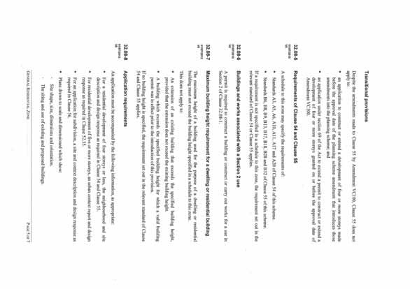
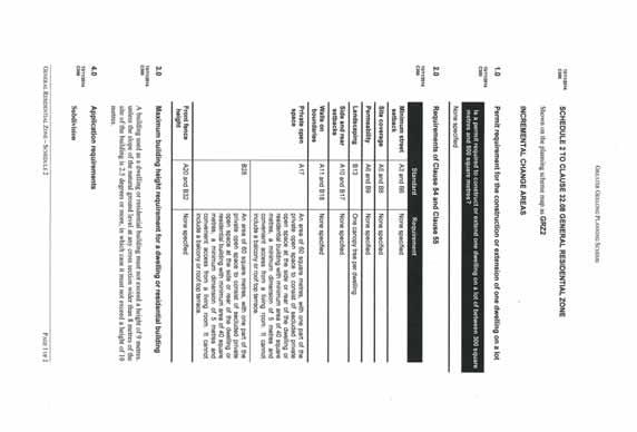
7 Comparison of the Schedules to the General Residential Zone Within the City of Greater Geelong the General Residential Zone has two schedules. Council s Housing Diversity Strategy forms the policy basis to support where each schedule has been applied. A schedule allows for certain planning application requirements to be varied from the standard requirements. In relation to the General Residential Zone this generally allows for variations to the standard Clause 54 and 55 (Rescode) requirements. Schedule 1 is the default schedule it does not vary any of the planning application requirements. Schedule 2 was been applied to areas where only incremental change is expected to occur. This schedule varies application requirements relating to the size of open space, landscaping, building height and subdivision. These variations seek to ensure the scale and space around new buildings is in keeping with the garden character of these suburbs. A copy of the General Residential Zone and the two schedules can be found at Appendix 1. Methodology This review reassessed the existing GRZ1 land within the municipality to determine if there are areas which have a defined garden character. Where areas are considered to have a garden character this report recommends that the areas are rezoned to GRZ2 to accommodate only moderate residential growth. The review excluded existing General Residential Zone 2 land, areas within an Increased Housing Diversity Area and where the land was used for school or recreation purpose. Land within the suburbs of Geelong West, Newtown, and Manifold Heights have also been excluded from this review as a change to the zoning of these suburbs was assessed as part of Amendment C300. Stage 1 Assessment Criteria used to establish a garden character The City of Greater Geelong does not have a definition of what is meant by the term garden character. However the term garden character is acknowledged within Councils Municipal Strategic Statement at Clause Neighbourhood Character. Garden character is considered to form part of an areas neighbourhood character. The original recommendations of the HDS to define incremental change areas were not based on establishing that an area had a garden character. The C129 Panel Report and then Planning Minister introduced the concept of garden character to support the inclusion or exclusion of the incremental change areas identified in Council s HDS. A desktop review of the study area was undertaken to establish what criteria or elements an area needed to posses to be considered to have a garden character. It was considered that there were five elements that contributed towards an area having a garden character. The information was sourced from Councils GIS database and the State Governments Housing Development Data. The data was mapped to allow for a comparison across each suburb within the GRZ1. For an area to be considered to have potential garden character, it would need to exhibit at least three of the five elements. The elements were: Building age construction pre 1965 s Page 7
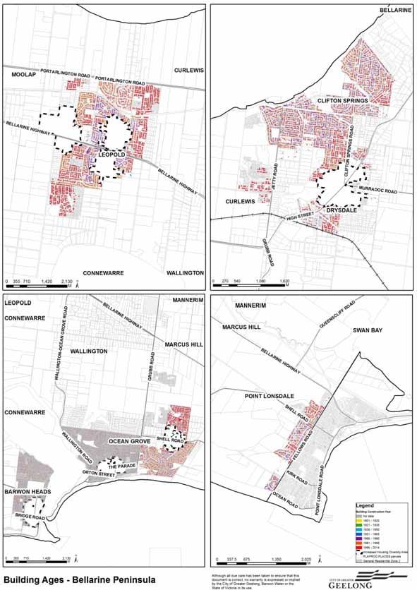
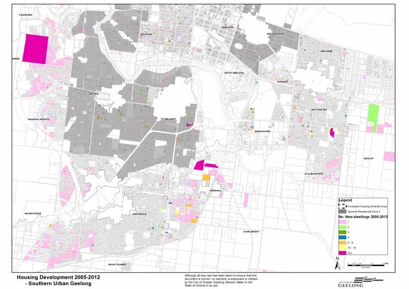
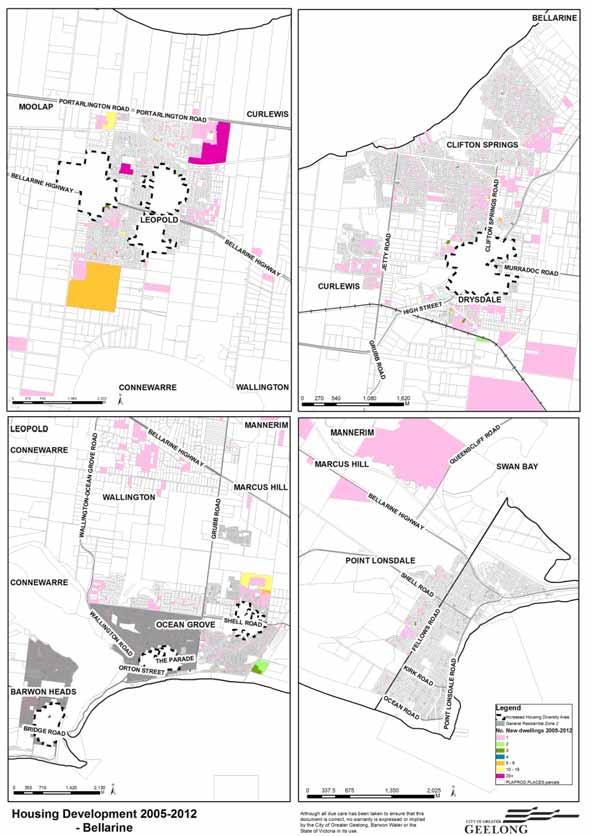
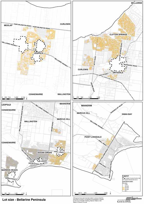
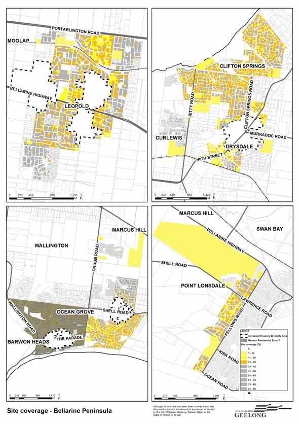
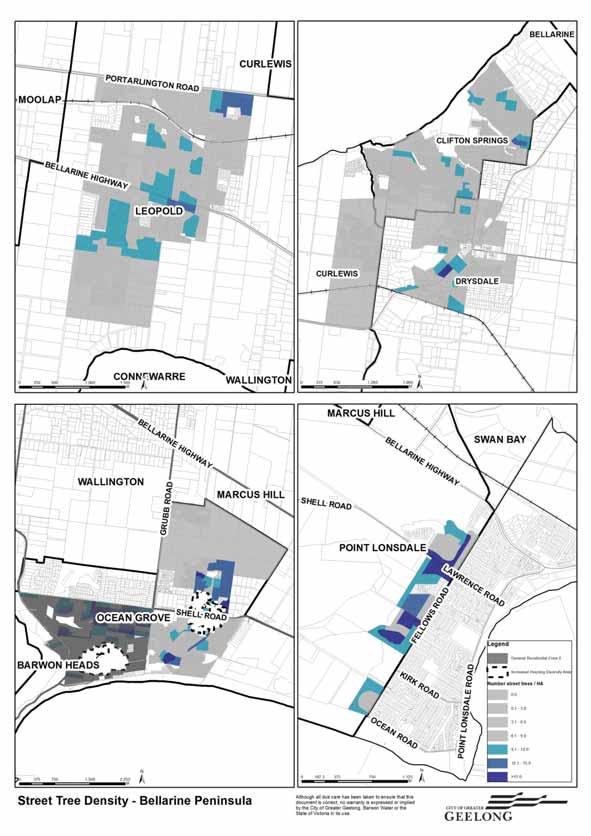
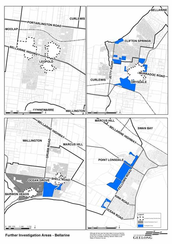
8 The suburbs which have been developed pre 1965 are well established, often with smaller housing footprints. In these locations there is generally space surrounding houses which have allowed for the planting of gardens and buildings to be setback from property boundaries. Appendix 2 is a map showing the age of buildings across the municipality. Housing Development Data The State Government prepared the Housing Development Data Report March 2012 for Greater Geelong. This report identifies the location and number of new housing developments that occurred from 2005 to This data has been mapped to establish where within the municipality there have been development pressures for medium density housing. Appendix 3 is a map showing housing development between 2005 and Lot size between 500 and 800 sqm; A review of all housing development data between for Greater Geelong revealed that a total of 9161 dwellings were approved. 843 of these were applications for multiple dwellings (2 or more). 409 or 48.5 % of these were approved on lots between m2. It is considered that lots between 500 and 800m2 occupied by a single dwelling generally have a spacious garden setting which could be impacted upon by the development of multiple dwellings Note: 58.2% or lots within all of Greater Geelong are between m2. Appendix 4 is a map showing the location of lots between 500 and 800sqm Site coverage less than 30% Areas with low site coverage generally have space surrounding dwellings which havs allowed for the planting of gardens and buildings to be setback from property boundaries. The average site coverage across land zoned GRZ1 is 32 % Appendix 5 is a map showing site coverage across the municipality. Street tree density greater than 9 trees per hectare Street trees add significant appeal to areas where they are present particularly in locations where they are well established. Street trees can add to the garden character of an area. Appendix 6 is a map showing street tree density across the municipality From this initial assessment 75 areas were identified as exhibiting garden character elements. Appendix 7 shows the locations of these further investigation areas. Stage 2 Further Investigation Areas To further refine whether these areas had a garden character a site visit to each area was undertaken. During the site visits the following characteristics were observed; Page 8 Setting or space around buildings, providing an opportunity for planting. On site vegetation or an established garden was present Condition and appearance of buildings including the approximate age of the buildings Presence of a nature strip and footpath. Confirmation of street tree planting, new or recently established plantings.
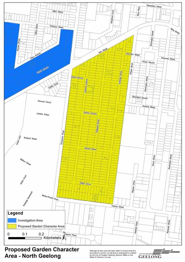
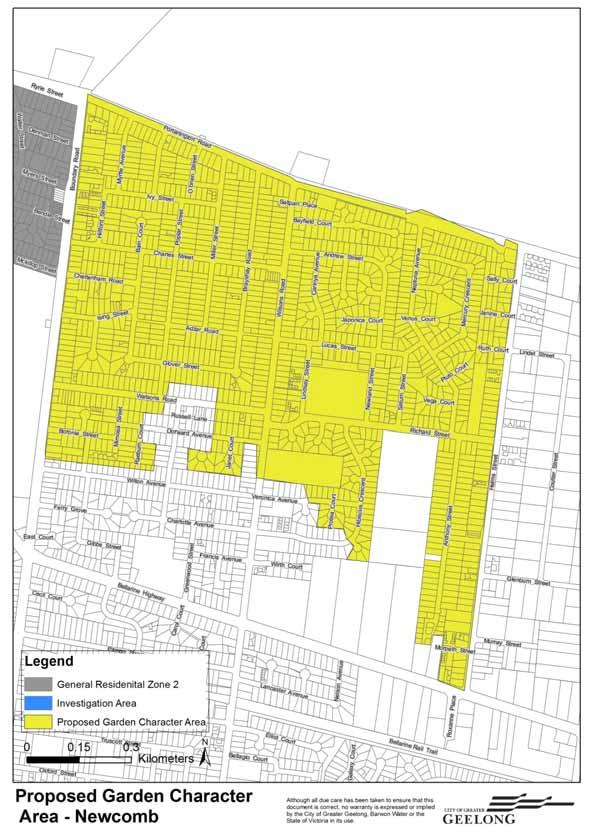
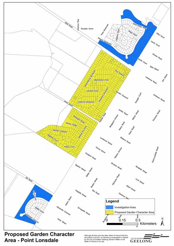
9 For an area to have garden character it would need to exhibit all of the above elements. From the site visits it was determined that there were 4 areas which exhibited a garden character. The observations from the site visits are explained in more detail below: Bell Post Hill The Bell Post Hill further investigation area is located to the north of Central Geelong between the Geelong Ring Road and Anakie Road. The area is characterised by a mixture of brick and weatherboard dwellings on allotments predominantly between 500 and 800 square metres. The majority of dwellings were constructed pre 1965 and this is reflective in the overall size of buildings and the style of dwellings present on lots. The site coverage of the majority of properties is low and buildings are often offset from both side boundaries. Garaging is located at the rear of properties or not present at all. Carports appear to be common and are located to the side of dwellings. Many of the dwellings in the area are elevated to take advantage of the views towards Corio Bay or the You Yang s. The area has a significant number of street trees which add to the visual appeal of the area. Properties also have established gardens of a modest scale with a combination of lawn, trees and small shrubs. Front gardens are generally well maintained and add significantly to the appearance and character of the areas. Footpaths are generally present on both sides of a street. Buildings appear to be in good condition with some infill development occurring including multi dwelling developments. North Geelong The North Geelong further investigation area is located between Thompson Road to the west, Kerr Street to the north, Kildare Street to the east and Victoria Street to the South. The area is characterised by a mixture of brick and weatherboard dwellings predominantly on allotments between 500 and 800 square metres. The majority of dwellings were constructed pre 1965 and this is reflective in the overall size of buildings and the style of dwellings present on lots. The site coverage of the majority of properties is low and buildings are often offset from both side boundaries. Garaging is located at the rear of properties or not present at all. Carports appear to be common and are located to the side of dwellings. The area has a significant number of street trees which add to the visual appeal of the area. The appearance of street trees appears more prominent as a result of the length of the northsouth streets. Properties also have established gardens of a modest scale with a combination of lawn, trees and small shrubs. Front gardens are generally well maintained and add significantly to the appearance and character of the areas. Footpaths are generally present on both sides of a street. Buildings appear to be in good condition with some infill development occurring including multi dwelling developments. Newcomb The Newcomb further investigation area is located between Boundary Road to the west, Portarlington Road to the north, Helms Street to the East and the Residential Growth Zone land to the south. The area consists of a mixture of brick and weatherboard dwellings on allotments predominantly between 500 and 800 square metres. The majority of dwellings were constructed pre 1965 and this is reflective in the overall size of buildings and the style of dwellings present on lots. Page 9
10 The site coverage of the majority of properties is low and buildings are often offset from both side boundaries. Garaging is located at the rear of properties or not present at all. Carports appear to be common and are located to the side of dwellings. The area has established street trees although not as many as the other identified further investigation areas, the trees still add to the visual appeal of the area. Properties also have established gardens of a modest scale with a combination of lawn, trees and small shrubs. Front gardens are generally well maintained and add significantly to the appearance and character of the areas. Footpaths are generally located on both sides of a street. Buildings appear to be in poor to good condition with some infill development occurring including multi dwelling construction. There is a visual change in the appearance and condition of housing between the east and west sides of Wilsons Road. This is likely to be a result of a larger concentration of older housing stock (pre 1965) being present on the eastern side of Wilsons Road. Point Lonsdale The Point Lonsdale further investigation area is located in the south eastern tip of the municipality. Point Lonsdale is a sea side township which was mainly developed during the 1990 s. The area is characterised by a mixture of brick and weatherboard dwellings set amongst coastal vegetation. There are no footpaths within the area and street tree planting often mixes with plantings on private property. This mix helps to create a coastal setting within the surrounding area. The site coverage of the area is relatively low however newer dwellings tend to be larger and located on smaller lots. In Pt Lonsdale garaging tends to be attached to dwellings although dwellings are still setback from one or more boundaries. Dwellings appear to be in good condition with some infill development occurring including multi dwelling developments. A map showing the location of the 4 areas is at appendix 8. Policy Context There is State and Local Planning Policy support to zone land in accordance with Council s housing strategies and preferred direction for growth. This review is supported by the following State and Local Planning Policies. State Planning Policy Framework Clause 11 Settlement Planning is to anticipate and respond to the needs of existing and future communities through provision of zoned and serviced land for housing, employment, recreation and open space, commercial and community facilities and infrastructure. Clause Supply of urban land To ensure a sufficient supply of land is available for residential, commercial, retail, industrial, recreational, institutional and other community uses. Strategies Ensure the ongoing provision of land and supporting infrastructure to support sustainable urban development. Ensure that sufficient land is available to meet forecast demand. Plan to accommodate projected population growth over at least a 15 year period and provide clear direction on locations where growth should occur. Residential land supply will be considered on a municipal basis, rather than a town-by-town basis. Page 10
11 Planning for urban growth should consider: Opportunities for the consolidation, redevelopment and intensification of existing urban areas. Neighbourhood character and landscape considerations. The limits of land capability and natural hazards and environmental quality. Service limitations and the costs of providing infrastructure. Monitor development trends and land supply and demand for housing and industry. Maintain access to productive natural resources and an adequate supply of well-located land for energy generation, infrastructure and industry. Restrict low-density rural residential development that would compromise future development at higher densities. Clause Regional settlement networks To promote the sustainable growth and development of regional Victoria through a network of settlements identified in the Regional Victoria Settlement Framework plan. Strategies Deliver networks of high-quality settlements by: Building on strengths and capabilities of each region across Victoria to respond sustainably to population growth and changing environments. Balancing strategic objectives to achieve improved land-use and development outcomes at a regional, catchment and local level. Preserving and protecting features of rural land and natural resources and features to enhance their contribution to settlements and landscapes. Providing for appropriately located supplies of residential, commercial, and industrial land across a region, sufficient to meet community needs in accordance with the relevant regional growth plan. Clause Melbourne s hinterland areas To manage growth in Melbourne s hinterland, the area immediately beyond Metropolitan Melbourne and within 100 kilometres of the Melbourne s Central City. Strategies Maintain the attractiveness and amenity of hinterland towns. Strengthen and enhance the character and identities of towns. Clause Coastal settlement To plan for sustainable coastal development. Strategies Support a network of diverse coastal settlements which provides for a broad range of housing types, economic opportunities and services. Clause 16 Housing Planning should provide for housing diversity, and ensure the efficient provision of supporting infrastructure. Strategies Ensure that the planning system supports the appropriate quantity, quality and type of housing, including the provision of aged care facilities. Clause Housing diversity To provide for a range of housing types to meet increasingly diverse needs. Strategy Encourage the development of well-designed medium-density housing which: Respects the neighbourhood character. Improves housing choice. Makes better use of existing infrastructure. Improves energy efficiency of housing. Page 11
12 Clause 15 Built environment and heritage Planning should ensure all new land use and development appropriately responds to its landscape, valued built form and cultural context, and protect places and sites with significant heritage, architectural, aesthetic, scientific and cultural value. Clause Cultural identity and neighbourhood character To recognise and protect cultural identity, neighbourhood character and sense of place. Strategies Ensure development responds and contributes to existing sense of place and cultural identity. Ensure development recognises distinctive urban forms and layout and their relationship to landscape and vegetation. Ensure development responds to its context and reinforces special characteristics of local environment and place by emphasising: The underlying natural landscape character. The heritage values and built form that reflect community identity. The values, needs and aspirations of the community. Local Planning Policy Framework Clause City of Greater Geelong Sustainable Growth Framework Managing Urban Growth Council will: Set clear settlement boundaries and consolidate development within those boundaries in a managed way. Encourage diversity in all communities. Clause Settlement and Housing Clause Urban growth To improve housing affordability through the maintenance of appropriate urban land supplies, the promotion of competition in the housing market and the development of a diverse range of well located housing stock. Clause Urban consolidation To provide for the consolidation of existing urban areas in a managed way. To encourage an appropriate range of development densities. To improve accessibility to urban services. Manage urban consolidation and housing change across the municipality, by: Accommodating medium and high density housing in Key Development Areas (as defined by the maps included in this clause). Maximising opportunities for housing within Increased Housing Diversity Areas (as defined in Clause Increased Housing Diversity Areas) by accommodating; high density housing in the activity centres consistent with their primary commercial and retail role; and medium density housing in residential areas with more intensive development being located closest to the core of activity centres. Supporting appropriate medium density housing in the General Residential Zone (Schedule 1) areas. Providing for incremental change in the General Residential Zone (Schedule 2) areas. Limiting change in the Neighbourhood Residential Zone areas. Clause Neighbourhood character To manage the impact of urban change on existing neighbourhoods. To ensure that new development responds to the existing neighbourhood character. To protect areas with a significant garden character. To protect areas with views to significant landscape features. Page 12
13 Strategies Ensure that development is responsive to the established character of the area. Support appropriate medium density housing that respects the existing neighbourhood character in the General Residential Zone areas. Response to State and Local Planning Policy The introduction of additional GRZ2 land will improve housing diversity within the municipality. It will provide clear policy direction regarding Councils preferred location for different types of housing particularly medium density housing. The rezoning of land will help to protect the existing garden character of established suburbs. The use of the GRZ2 zone will ensure that where new multi dwelling development occurs there is a requirement to provide a more spacious setting helping to protect the existing garden character of these areas. Discussion This review determined that 4 of the 75 review areas exhibit a garden character. These areas include Bell Post Hill, North Geelong, Newcomb and Pt Lonsdale. Within these areas there are approximately 4330 lots which are recommended to be rezoned from GRZ1 to GRZ2. Amendment C129 Panel Recommendations The C129 Panel report makes reference to using Council s Residential Character Precinct Brochures to help establish areas that have a garden character. Amendment C300 removed the reference to these brochures from the planning scheme as they were considered out of date and too generic to provide assistance in establishing the character of an area. Garden Character The determining factors when considering whether land should be zoned GRZ1 or GRZ2 is the presence of a garden character as indicated in the C129 Panel Report and subsequent Ministerial approval process. From a desktop review and site visits of the 75 areas it was considered that garden character was made up of a number of features including; Space around buildings including buildings being offset from property boundaries. Street appeal i.e. presence of street trees and nature strips Lack of garaging or garaging being sited at the rear. Small building footprints resulting in low site coverage. Mature private gardens Environmental factors including retention of existing vegetation. Overall it was determined that these features tend to be present in the older more established areas of Urban Geelong. The exception to this is Point Lonsdale, which due to its sensitive coastal location has resulted in more site responsive dwelling development in keeping with the environmental characteristics of the area. These features are different to those that create a heritage precinct. This review has not placed an emphasis on the architectural or historical background to the development of an area. There has also been no consideration given to the dwelling style or type, a contiguous construction era or historical subdivision pattern that is often critical in establishing the heritage significance of an area. Use of the General Residential Zone 2 A key objective of the General Residential Zone is to protect the neighbourhood character of an area. Landscape character forms part of an areas neighbourhood character. The areas where the GRZ2 is to be applied have been identified within this review as having a more prominent garden character than other locations across Greater Geelong. The GRZ2 is considered to be the most appropriate zone to apply to these areas. This zone supports incremental growth and seeks through variations to the zone schedule to provide opportunities to protect and build upon Page 13
14 the garden character of these areas. This approach is consistent with the application of the GRZ2 through the C300 amendment process. Reformed Zones and Impact on Housing Supply Recent zone reform has provided more certainty to the development industry and the wider community about where Council is seeking different forms of housing. Changes to Clause of Council s Municipal Strategic Statement, zone objectives, and the introduction of new zone schedules give policy support to encourage higher density development within and around activity centres and lower densities away from these centres. It is envisaged that over time the density of housing will increase in accordance with the new zoning provisions. The introduction of additional GRZ2 land will not significantly impact on the ability of Council to meet housing demand or housing choice across the municipality. Urban Geelong (excluding the Bellarine Peninsula) will need to accommodate an additional 1667 dwellings per annum till The majority of this demand will be met within the Armstrong Creek, Lara and Fyansford Residential Growth Areas with the remainder being infill development. The introduction of additional GRZ2 land will not result in a reduced number of infill development opportunities within the existing suburbs of Geelong. The changes to zoning controls have strengthened policy support for higher density development within other parts of Geelong. Within the existing General Residential Zone 1 study area there were 9161 lots developed with new housing between 2005 and A total of 5077 of these lots (55%) were between 500 and 800sqm in area. A large proportion of lots in the size range (5042 lots or 99.7%) were developed with up to two dwellings (91%) of these lots were developed with 1 dwelling. This data indicates that within Greater Geelong lots of between 500 and 800 sqm generally support development of up to two dwellings. There are 3,428 lots (85.7%) within proposed GRZ2 areas that are between 500 and 800sqm. It is not anticipated that there would be a significant change to the number of dwellings developed on a lot within the GRZ2, when compared to the development densities achieved in the past. There may be a reduction in the size of a building footprint as a result of the requirement for larger open space areas, but this is not considered significant enough to result in a reduced number of dwellings. It is therefore anticipated that the level of dwelling density previously experienced within these areas would be likely to continue within the GRZ2. Higher densities may be achieved if it can be demonstrated that development meets the variations contained within the schedule to the GRZ2. Recommendations It is recommended that a planning scheme amendment be undertaken to rezone the four garden character areas identified in the map at appendix 8, known as Bell Post Hill, North Geelong, Newcomb and Point Lonsdale to be GRZ22. Existing planning policy is sufficient to support incremental growth in these locations and therefore there is no requirement to make changes to the Municipal Strategic Statement. Conclusion This review finalises the application of the reformed residential zones into the Greater Geelong Planning Scheme by implementing the further work requirement to undertake this review at Clause of Council s Municipal Strategic Statement. The review also seeks to implement the recommendations of the C129 panel report and respond to submissions received as part of the C300 amendment process. The recommendations of this review will provide clear policy direction for the community and development industry about the preferred location for conventional, medium and high density housing. This review has established criteria to define 1 Residential Land Supply Monitoring Project G21 Region (Geelong)Oct 2013 Final Page 14
15 what is meant by the term garden character within the City of Great Geelong. The garden character of the four proposed incremental change areas will be protected and enhanced through the addition of stringent application requirements which will require additional space to be provided around dwellings allowing for planting and buildings to be setback from property boundaries. The recommendations of the review are supported by State and Local Planning Policy and will help to protect the neighbourhood character of areas which have an identified garden character. Page 15

16 APPENDIX 1 GENERAL RESIDENTIAL ZONE Page 16
17 Page 17
18 Page 18
19 Page 19
20 Page 20

21 APPENDIX 2 BUILDING AGES Page 21
22 Page 22
23 Page 23

24 APPENDIX 3 STATE GOVERNMENT HOUSING DEVELOPMENT DATA Page 24
25 Page 25
26 Page 26
27 Page 27

28 APPENDIX 4 LOCATION OF LOTS BETWEEN 500 AND 800 SQM Page 28
29 Page 29

30 APPENDIX 5 SITE COVERAGE Page 30
31 Page 31

32 APPENDIX 6 STREET TREE DENSITY Page 32
33 Page 33

34 APPENDIX 7 LOCATION OF FURTHER INVESTIGATION AREAS Page 34
35 Page 35

36 APPENDIX 8 PROPOSED GARDEN CHARACTER AREAS Page 36
37 Page 37
38 Page 38
39 Page 39
Casey Planning Scheme Amendment C207 Part 2 Evan and Margaret Street Precinct, Berwick
 Planning and Environment Act 1987 Panel Report Casey Planning Scheme Amendment C207 Part 2 Evan and Margaret Street Precinct, Berwick 14 January 2019 Planning and Environment Act 1987 Panel Report pursuant
STRATEGIC IMPLEMENTATION PANEL SUBMISSION
 STRATEGIC IMPLEMENTATION PANEL SUBMISSION AMENDMENT C375 to the GREATER GEELONG PLANNING SCHEME BARWON HEADS STRUCTURE PLAN IMPLEMENTATION Part A Submission to the Independent Panel Panel: Con Tsotsoros
DAREBIN PLANNING SCHEME AMENDMENT C137
 Who is the planning authority? Planning and Environment Act 1987 DAREBIN PLANNING SCHEME AMENDMENT C137 EXPLANATORY REPORT This amendment has been prepared by the Darebin City Council, who is the planning
4 RESIDENTIAL ZONE. 4.1 Background
 4 RESIDENTIAL ZONE 4.1 Background The residential areas within the City are characterised by mainly lowrise dwellings sited on individual allotments. Past architectural styles, settlement patterns and
Town Planning Report. Combined Planning Permit and Planning Scheme Amendment Request under Section 96A of the Planning and Environment Act 1987
 Town Planning Report Combined Planning Permit and Planning Scheme Amendment Request under Section 96A of the Planning and Environment Act 1987 1 Henry Street, Belmont Prepared by Tract Consultants for
Appendix 1 Structure plan guidelines
 Appendix 1 Structure plan guidelines This appendix forms part of the regional policy statement [rps]. 1.1. Introduction Structure plans are an important method for establishing the pattern of land use
Tāhuhu whakaruruhau ā-taone The sheltering ridge pole
 B2. Tāhuhu whakaruruhau ā-taone - Urban growth and form B2.1. Issues Tāhuhu whakaruruhau ā-taone The sheltering ridge pole Auckland s growing population increases demand for housing, employment, business,
CITY CLERK. Parkland Acquisition Strategic Directions Report (All Wards)
") CITY CLERK Clause embodied in Report No. 10 of the, as adopted by the Council of the City of Toronto at its meeting held on November 6, 7 and 8, 2001. 10 Parkland Acquisition Strategic Directions Report
CITY CLERK Clause embodied in Report No. 10 of the, as adopted by the Council of the City of Toronto at its meeting held on November 6, 7 and 8, 2001. 10 Parkland Acquisition Strategic Directions Report
I615. Westgate Precinct
 I615. Westgate Precinct I615.1. Precinct Description The Westgate Precinct is located approximately 18km west of the Auckland city centre. There are seven Sub-precincts in the Westgate Precinct: Sub-precinct
2A District-wide Policies
 2A Introduction This Chapter contains policies which are relevant to subdivision, use and development activities occurring across all zones and areas of the District. The policies in this Chapter implement
Plan Modification to Chapter B2 of the Auckland Unitary Plan(AUP) Operative in part (15 November 2016)
 Operative in part (15 November 2016)") UNITARY PLAN UPDATE REQUEST MEMORANDUM TO FROM Phill Reid Linley Wilkinson DATE 25 September 2018 SUBJECT Plan Modification to Chapter B2 of the Auckland Unitary Plan(AUP) Operative in part (15 November
UNITARY PLAN UPDATE REQUEST MEMORANDUM TO FROM Phill Reid Linley Wilkinson DATE 25 September 2018 SUBJECT Plan Modification to Chapter B2 of the Auckland Unitary Plan(AUP) Operative in part (15 November
CITY OF FREMANTLE LOCAL PLANNING SCHEME NO. 4 AMENDMENT NO. 68 SCHEME AMENDMENT REPORT
 CITY OF FREMANTLE LOCAL PLANNING SCHEME NO. 4 AMENDMENT NO. 68 SCHEME AMENDMENT REPORT CITY OF FREMANTLE PLANNING AND DEVELOPMENT SERVICES 8 WILLIAM STREET FREMANTLE WA 6160 PLANNING AND DEVELOPMENT ACT
The Proposed Auckland Unitary Plan (notified 30 September 2013)
") 3 Business zones Introduction There are 10 business zones in the Unitary Plan: City Centre Metropolitan Centre Town Centre Local Centre Neighbourhood Centre Mixed Use General Business Business Park Light
3 Business zones Introduction There are 10 business zones in the Unitary Plan: City Centre Metropolitan Centre Town Centre Local Centre Neighbourhood Centre Mixed Use General Business Business Park Light
A Growing Community Rural Settlement Areas
 Town of Huntsville Official Plan Review - POLICY BACKGROUND PAPER A Growing Community Rural Settlement Areas BACKGROUND: In addition to the fully municipally-serviced Urban Settlement Area and the Hidden
MATURE SUBURBS RESIDENTIAL DEVELOPMENT GUIDELINES
 MATURE SUBURBS RESIDENTIAL DEVELOPMENT GUIDELINES DRAFT FEBRUARY 2005 BIRMINGHAM CITY COUNCIL 1 Introduction Mature Suburbs Residential Development Guidelines - Interim Supplementary Planning Advice -
I Te Koti Taiao o Aotearoa Ōtautahi Rohe ENV-2018-CHC- Appellant. Queenstown Lakes District Council. Respondent
 In the Environment Court of New Zealand Christchurch Registry I Te Koti Taiao o Aotearoa Ōtautahi Rohe ENV-2018-CHC- Under In the matter of Between the Resource Management Act 1991 (RMA) An appeal under
Northern Territory Compact Urban Growth Policy
 Northern Territory Compact Urban Growth Policy A Reference Policy Document to clause 2.7 (Reference to Policy) of the NT Planning Scheme May 2015 Table of Contents 1 Policy Setting... 3 1.1 Context for
SCHEDULE 10 TO THE URBAN GROWTH ZONE. Shown on the planning scheme map as UGZ10. Truganina Precinct Structure Plan. 1.0 The Plan
 SCHEDULE 10 TO THE URBAN GROWTH ZONE Shown on the planning scheme map as UGZ10 Truganina Precinct Structure Plan 1.0 The Plan Map 1 shows the future urban structure proposed in the Truganina Precinct Structure
Extract from Whitehorse Planning Scheme - LOCAL PLANNING POLICIES - CLAUSE Preferred Character Statements
 Extract from Whitehorse Planning Scheme - LOCAL PLANNING POLICIES - CLAUSE 22.03 22.03-5 Preferred Character Statements Bush Environment The streetscapes will be dominated by vegetation with subservient
SECTION 2.4 URBAN DEVELOPMENT AND STRATEGIC URBAN DIRECTIONS
 SECTION 2.4 URBAN DEVELOPMENT AND STRATEGIC URBAN DIRECTIONS 2.4.1 INTRODUCTION In 1993/94 the Hastings District Council completed the Hastings Urban Development Strategy. The purpose of this study was:
Cotswolds AONB Landscape Strategy and Guidelines. June 2016
 Cotswolds AONB Landscape Strategy and Guidelines June 2016 Cotswolds AONB Landscape Strategy and Guidelines Introduction The evolution of the landscape of the Cotswolds AONB is a result of the interaction
CASEY PLANNING SCHEME AMENDMENT C188
 Who is the planning authority? Planning and Environment Act 1987 CASEY PLANNING SCHEME AMENDMENT C188 EXPLANATORY REPORT This amendment has been prepared by the Growth Areas Authority (now known as the
DRAFT PLANNING SCHEME AMENDMENT GC81
 Outline of changes proposes to the Melbourne and Port Phillip Planning Scheme Fishermans Bend Fishermans Bend is one of several priority precincts identified in Plan Melbourne and plays a central role
North District What we heard
 What we heard Vision to 2056 and Priorities Governance and implementation Infrastructure and funding The vision for a metropolis of three cities, and the 30 minute city. Feedback emphasised: That for the
Official Plan Review
 Official Plan Review Summary Report - The Built Environment August 2014 Part 1: Introduction Planning for a healthy, prosperous and sustainable community is an important goal for our municipality. From
Draft Eastern District Plan
 Draft Eastern District Plan Submission_id: 31238 Date of Lodgment: 13 Dec 2017 Origin of Submission: Online Organisation name: Turrulla Gardens Pty Ltd C/- Mecone Organisation type: Industry First name:
OCEAN GROVE STRUCTURE PLAN
 OCEAN GROVE STRUCTURE PLAN December 2015 1 WWW.GEELONGAUSTRALIA.COM.AU 2 Contents Part A Structure Plan 1 Introduction... 5 1.1 Purpose of the Structure Plan 5 1.2 How will this plan be used? 5 1.3 Plan
Appendix A. Planning Processes. Introduction
 1 Planning Processes Introduction This appendix outlines a number of planning processes which are used in the Auckland Region to support the effective management of development in the region s rural and
WINCHESTER TOWN 3.1 LOCATION, CHARACTERISTICS & SETTING
 WINCHESTER TOWN 3.1 LOCATION, CHARACTERISTICS & SETTING 3.1.1 The area referred to by the City Council, as Winchester Town, consists of the Winchester Wards plus the adjoining built up areas of Badger
ROCHFORD LOCAL DEVELOPMENT FRAMEWORK: Sustainability Appraisal/ Strategic Environmental Assessment. Rochford Core Strategy Preferred Options Document
 ROCHFORD LOCAL DEVELOPMENT FRAMEWORK: Sustainability Appraisal/ Strategic Environmental Assessment Non Technical Summary Rochford Core Strategy Preferred Options Document October 2008 SUSTAINABILITY APPRAISAL
APPENDIX 1 - OCEAN GROVE SIGNIFICANT TREE PROJECT SIGNIFICANT TREE AREA DEVELOPMENT PATTERNS 1960 S TO 2013
 APPENDIX 1 - OCEAN GROVE SIGNIFICANT TREE PROJECT SIGNIFICANT TREE AREA DEVELOPMENT PATTERNS 1960 S TO 2013 1966 1977 APPENDIX 1 - OCEAN GROVE SIGNIFICANT TREE PROJECT 1984 1990 APPENDIX 1 - OCEAN GROVE
EXAMPLE. Bushfire Management Statement Construction of a single dwelling in a Bushfire Management Overlay
 Bushfire Management Statement Construction of a single dwelling in a Bushfire Management Overlay EXAMPLE Bushfire Management Statement Construction of a single dwelling in a Bushfire Management Overlay
I539. Smales 2 Precinct
 I539. Smales 2 Precinct I539.1. Precinct Description The Smales 2 Precinct applies to a 4.8 hectare block of land located on the southern side of Northcote Road and fronting Lake Pupuke, Takapuna. The
CITY OF GREATER GEELONG
 CITY OF GREATER GEELONG AGENDA DEVELOPMENT HEARINGS PANEL MEETING NO 573 TO BE HELD AT BROUGHAM STREET OFFICE (GROUND FLOOR) 100 BROUGHAM STREET, GEELONG ON THURSDAY, 4 OCTOBER 2018 AT 5.00 P.M. 1. Committee
13 THORNHILL YONGE STREET STUDY IMPLEMENTATION CITY OF VAUGHAN OPA 669 AND TOWN OF MARKHAM OPA 154
 13 THORNHILL YONGE STREET STUDY IMPLEMENTATION CITY OF VAUGHAN OPA 669 AND TOWN OF MARKHAM OPA 154 The Planning and Economic Development Committee recommends the adoption of the recommendations contained
HOROWHENUA DEVELOPMENT PLAN June create a safe crossing for children moving to and from the school and other areas. 7.8 Ohau
 7.8 Ohau create a safe crossing for children moving to and from the school and other areas. Ohau has a traditional village form with a collective of school, church and reserve at the main road intersection.
1 The decision of the Responsible Authority is affirmed. 2 In permit application WH/2014/851, no permit is granted.
 VICTORIAN CIVIL AND ADMINISTRATIVE TRIBUNAL ADMINISTRATIVE DIVISION PLANNING AND ENVIRONMENT LIST VCAT REFERENCE NO. P754/2015 PERMIT APPLICATION NO.WH/2014/851 CATCHWORDS Section 77 of the Planning and
BELLARINE PENINSULA Draft Localised Planning Statement JUNE 2014
 BELLARINE PENINSULA Draft Localised Planning Statement JUNE 2014 BELLARINE PENINSULA Draft Localised Planning Statement JUNE 2014 The Bellarine Peninsula Draft Localised Planning Statement has been developed
Settlement Boundaries Methodology North Northumberland Coast Neighbourhood Plan (August 2016)
") Introduction This background paper sets out a methodology for the definition of settlement boundaries in the North Northumberland Coast Neighbourhood Plan. The neighbourhood plan is planning positively
Introduction This background paper sets out a methodology for the definition of settlement boundaries in the North Northumberland Coast Neighbourhood Plan. The neighbourhood plan is planning positively
RE: AMENDMENT C375 GEELONG PLANNING SCHEME 1900 BARWON HEADS ROAD, BARWON HEADS
 Reference: #V157080 14 August 2018 Barwon Heads Lifestyle Group Pty Ltd C/- Best Hooper Lawyers Level 9, 451 Little Bourke Street MELBOURNE VIC 3000 Attention: Mr. Edward Mahony (Lawyer) Dear Edward RE:
PMP PRINTING SITE COMMUNITY ENGAGEMENT - PHASE 2
 PMP PRINTING SITE COMMUNITY ENGAGEMENT - PHASE 2 FEBRUARY 2019 0317-0511 - PMP Printng - M001 (8 -Floors) -Final date 14.11.2018 Vision: The PMP Printing site will be transformed into a contemporary mixed-use
Planning Proposal Charlestown Swim and Leisure Centre LEP Amendment
 Planning Proposal Charlestown Swim and Leisure Centre LEP Amendment Amendment No. 4 to Lake Macquarie Local Environmental Plan 2014 (PP_2014_LAKEM_005_00) Local Government Area: Name of Draft LEP: Lake
Eastern Golf Course, Doncaster Road, Doncaster
 , 463-535 Road, Heritage Assessment in accordance with Schedule to the Development Plan Overlay July 2013 bryce raworth conservation urban design 19 Victoria Street St Kilda Vic 3182 , 463-535 Road, Heritage
PART AOTEA PRECINCT
 CONTENTS... PAGE AOTEA PRECINCT...4 14.5.1 INTRODUCTION...4 14.5.2 RESOURCE MANAGEMENT ISSUES...4 14.5.3 RESOURCE MANAGEMENT OBJECTIVES AND POLICIES... 4 14.5.4 RESOURCE MANAGEMENT STRATEGY...5 14.5.5
SUSTAINABLE MANAGEMENT
 . Sustainable Management.1 The Concept of Sustainable Management The concept of sustainable management recognises there are limits to the use of natural and physical resources and there is a need to balance
Oxford Green Belt Study. Summary of Final Report Prepared by LUC October 2015
 Oxford Green Belt Study Summary of Final Report Prepared by LUC October 2015 Project Title: Oxford Green Belt Study Client: Oxfordshire County Council Version Date Version Details Prepared by Checked by
LEOPOLD STRUCTURE PLAN. Prepared by the City of Greater Geelong September 2011 (Amended Jan 2013)
") LEOPOLD STRUCTURE PLAN Prepared by the City of Greater Geelong September 2011 (Amended Jan 2013) Table of Contents PART A STRUCTURE PLAN 1.0 Introduction... 3 1.2 How will this plan be used?... 3 1.3 Plan
LEOPOLD STRUCTURE PLAN Prepared by the City of Greater Geelong September 2011 (Amended Jan 2013) Table of Contents PART A STRUCTURE PLAN 1.0 Introduction... 3 1.2 How will this plan be used?... 3 1.3 Plan
Stantonbury Neighbourhood Plan
 Stantonbury Neighbourhood Plan 2018-2031 Basic Conditions Statement October 2018 Intentionally blank 1.0 Basic Conditions Statement Introduction 1.1 This statement has been prepared by Stantonbury Parish
WELLINGTON HOSPITAL DESIGN GUIDE TABLE OF CONTENTS
 WELLINGTON HOSPITAL DESIGN GUIDE TABLE OF CONTENTS 1.0 Introduction Page 2 The Place of Wellington Hospital 2 The Future of the Hospital 2 2.0 The Intention of the Design Guide 3 3.0 Analysis 4 General
Newcourt Masterplan. November Exeter Local Development Framework
 Newcourt Masterplan November 2010 Exeter Local Development Framework Background The Exeter Core Strategy Proposed Submission sets out the vision, objectives and strategy for the development of Exeter up
URBAN DEVELOPMENT QLDC PROPOSED DISTRICT PLAN [PART TWO] AUGUST 2015
![URBAN DEVELOPMENT QLDC PROPOSED DISTRICT PLAN [PART TWO] AUGUST 2015](/thumbs/80/81778199.jpg "URBAN DEVELOPMENT QLDC PROPOSED DISTRICT PLAN [PART TWO] AUGUST 2015") 4 URBAN VLOPMNT U R P QLC PROPO ITRICT PLAN [PART TWO] AUGUT 2015 4 ur b an de v elop ment QLC ITRICT PLAN [PART TWO] AUGUT 2015 4 urban development 4 2 4.1 Purpose The purpose of this Chapter is to set
4 URBAN VLOPMNT U R P QLC PROPO ITRICT PLAN [PART TWO] AUGUT 2015 4 ur b an de v elop ment QLC ITRICT PLAN [PART TWO] AUGUT 2015 4 urban development 4 2 4.1 Purpose The purpose of this Chapter is to set
Planning Proposal Concurrent DA/LEP Amendment for Belmont North Pharmacy Amendment No. 24 to Lake Macquarie Local Environmental Plan (LMLEP) 2014
 2014") Planning Proposal Concurrent DA/LEP Amendment for Belmont North Pharmacy Amendment No. 24 to Lake Macquarie Local Environmental Plan (LMLEP) 2014 Local Government Area: Name of Draft LEP: Subject Land:
Planning Proposal Concurrent DA/LEP Amendment for Belmont North Pharmacy Amendment No. 24 to Lake Macquarie Local Environmental Plan (LMLEP) 2014 Local Government Area: Name of Draft LEP: Subject Land:
Highett Structure Plan Review
 Highett Structure Plan Review February 2017 CONTENTS 1. Introduction 4 1.1.Scope of the review 4 2. Policy Context 6 2.1 State Planning Framework 6 2.2 Local Planning Framework 7 2.3 Bayside City Council
PLANNING AND ENVIRONMENT LIST. FORM B STATEMENT OF GROUNDS To be completed by Referral Authorities and objectors
 PLANNING AND ENVIRONMENT LIST FORM B STATEMENT OF GROUNDS To be completed by Referral Authorities and objectors To: The Principal Registrar Victorian Civil and Administrative Tribunal 55 King Street MELBOURNE
LONGDEN VILLAGE DEVELOPMENT STATEMENT
 LONGDEN VILLAGE DEVELOPMENT STATEMENT 2017-2027 1 Longden Development Statement 2017-2027 15/01/18 1. Background 1.1 Longden Village Longden village is a very rural and traditional community first mentioned
C176. Amendment C176 Riverdale Precinct Structure Plan List of Document Changes for Planning Panels Victoria. Version th November 2013
 C176 Amendment C176 Riverdale Precinct Structure Plan List of Document Changes for Planning Panels Victoria Version 1.0 18 th November 2013 Amendment C176 Riverdale Precinct Structure Plan List of Document
PUBLIC NOTICE UNDER CLAUSE 5 OF SCHEDULE 1 OF THE RESOURCE MANAGEMENT ACT 1991 PLAN CHANGE 12 TO THE OPERATIVE CITY OF NAPIER DISTRICT PLAN
 PUBLIC NOTICE UNDER CLAUSE 5 OF SCHEDULE 1 OF THE RESOURCE MANAGEMENT ACT 1991 PLAN CHANGE 12 TO THE OPERATIVE CITY OF NAPIER DISTRICT PLAN Public notice is given in accordance with Clause 5 of Schedule
Section 32 Evaluation Report Variation 1 - Arrowtown Design Guidelines, 2016 Contents
 Section 32 Evaluation Report Variation 1 - Arrowtown Design Guidelines, 2016 Contents Section 32 Evaluation Report: Variation 1 - Arrowtown Design Guidelines, 2016 (ADG, 2016)... 3 1. Strategic Context...
280 Manse Road - Official Plan Amendment, Zoning Amendment, Draft Plan of Subdivision Applications - Preliminary Report
 STAFF REPORT ACTION REQUIRED 280 Manse Road - Official Plan Amendment, Zoning Amendment, Draft Plan of Subdivision Applications - Preliminary Report Date: March 11, 2014 To: From: Wards: Reference Number:
Schedule of Planning Applications Committee Date: 23 May Reference: 06/17/0726/F Parish: Hemsby Officer: Mr J Beck Expiry Date:
 Schedule of Planning Applications Committee Date: 23 May 2018 Reference: 06/17/0726/F Parish: Hemsby Officer: Mr J Beck Expiry Date: 22-05-2018 Applicant: Proposal: Site: Mr Gillett Change of use to the
WHERE DO WE GROW FROM HERE?
 WHERE DO WE GROW FROM HERE? Have your say. HAVE YOUR SAY ON THE NELSON TASMAN FUTURE DEVELOPMENT STRATEGY Nelson and Tasman are growing fast and we continue to need more houses for people to live in, places
WELCOME GYPSY LANE. Wider Site Location plan. Proposals for the development of LAND OFF FOXLYDIATE LANE WEBHEATH. Proposals for the development of
 WELCOME The developers are preparing an outline planning application for a residential led development and need the community s views in order to develop the proposals further WHAT IS PROPOSED? A high
TABLE OF CONTENTS. Human Habitats, 155 Dorcas St South Melbourne, Victoria 3205
 TARNEIT JUNCTION Town Planning Report DECEMBER 2013 TABLE OF CONTENTS Table of contents... 1 1 Introduction... 2 2 SIte context and surrounds... 4 2.1 Site Features... 4 2.2 Surrounding land uses... 4
SECTION ONE North East Industrial Zone Design Guide Palmerston North City Council June 2004
 SECTION ONE North East Industrial Zone Design Guide Palmerston North City Council June 2004 young heart easy living 1 Preface Industrial areas are a very important component of the economic well-being
EAST VILLAGE STRATEGIC SITE NOVEMBER 2017
 EAST VILLAGE STRATEGIC SITE NOVEMBER 2017 East Village will be a sustainable, mixeduse precinct with a focus on innovative employment and education opportunities. Enhanced by green spaces and places for
Land Use Amendment in Southwood (Ward 11) at and Elbow Drive SW, LOC
 at and Elbow Drive SW, LOC") 2018 November 15 Page 1 of 10 EXECUTIVE SUMMARY This land use amendment application was submitted by Rick Balbi Architect on 2017 August 31 on behalf of Sable Developments Ltd, and with authorization from
2018 November 15 Page 1 of 10 EXECUTIVE SUMMARY This land use amendment application was submitted by Rick Balbi Architect on 2017 August 31 on behalf of Sable Developments Ltd, and with authorization from
Implementing sustainable water strategy through development industry engagement
 Implementing sustainable water strategy through development industry engagement Ian Director, Organica Engineering, Melbourne, Australia E-mail: iadams@organicaeng.com.au Edward Cotter Sustainability Leader,
5 TOWN OF MARKHAM OFFICIAL PLAN AMENDMENT NO. 144 MILLIKEN MAIN STREET SECONDARY PLAN
 5 TOWN OF MARKHAM OFFICIAL PLAN AMENDMENT NO. 144 MILLIKEN MAIN STREET SECONDARY PLAN The Planning and Economic Development Committee recommends the following: 1. The communication from Brendan O Callaghan,
Greater Geelong Planning Scheme Amendment C349 Ocean Grove Significant Tree Project
 Planning and Environment Act 1987 Panel Report Greater Geelong Planning Scheme Amendment C349 Ocean Grove Significant Tree Project 13 December 2017 Planning and Environment Act 1987 Panel Report pursuant
Description Details submitted pursuant to discharge of condition 5 (Design Code) attached to planning permission 13/01729/OUT.
 attached to planning permission 13/01729/OUT.") ITEM 9 Application Number: 18/00266/DISCON Description Details submitted pursuant to discharge of condition 5 (Design Code) attached to planning permission 13/01729/OUT. AT The Point, 602 Midsummer Boulevard,
ITEM 9 Application Number: 18/00266/DISCON Description Details submitted pursuant to discharge of condition 5 (Design Code) attached to planning permission 13/01729/OUT. AT The Point, 602 Midsummer Boulevard,
DRYSDALE - CLIFTON SPRINGS STRUCTURE PLAN Prepared by the City of Greater Geelong Adopted September 2010
 DRYSDALE - CLIFTON SPRINGS STRUCTURE PLAN Prepared by the City of Greater Geelong Adopted September 2010 Table of Contents PART A STRUCTURE PLAN 1 1.0 Introduction... 1 1.1 Purpose of the Structure Plan...
PLANNING RATIONALE FOR ZONING BY-LAW AMENDMENT MINTO COMMUNITIES INC. ARCADIA RESIDENTIAL STAGES 3 & 4 ARCADIA COMMERCIAL STAGE 2 CITY OF OTTAWA
 PLANNING RATIONALE FOR ZONING BY-LAW AMENDMENT MINTO COMMUNITIES INC. ARCADIA RESIDENTIAL STAGES 3 & 4 ARCADIA COMMERCIAL STAGE 2 CITY OF OTTAWA Prepared for: MINTO COMMUNITIES INC. 180 Kent Street, Suite
TIDAPA Structure Plan
 TIDAPA Structure Plan Prepared by Tract Consultants 28 MARCH 2017 0217-0074 Table of Contents 01 STRATEGIC CONTEXT Executive Summary Regional Context Page 3 Page 4 02 LOCAL CONTEXT Aerial Photograph Local
Western City District What we heard
 What we heard Vision to 2056 and Priorities Governance and implementation Infrastructure and funding The protection of the natural landscape including biodiversity and the Metropolitan Rural Area for food
Strategic Environmental Assessment Screening Report. Dublin Port Masterplan Review 2017
 Strategic Environmental Assessment Screening Report Dublin Port Masterplan Review 2017 Table of Contents 1 Introduction... 1 2 Purpose of the Masterplan... 2 3 Task 1.1 Pre-Screening Check... 5 4 Task
Blandford Forum Town Council, Blandford St Mary Parish Council and Bryanston Parish Council
 Blandford Forum Town Council, Blandford St Mary Parish Council and Bryanston Parish Council Blandford + Neighbourhood Plan 2 Pre-Submission Plan Consultation (November 2018) Representations submitted on
REMARKABLES PARK ZONE
 .10 Remarkables Park Zone.10.1 Resources, Activities and Values The Remarkables Park Area comprises approximately 150 hectares of perimeter urban land in the vicinity of Frankton and occupies a strategic
LARA STRUCTURE PLAN Prepared by the City of Greater Geelong Adopted April 2011
 LARA STRUCTURE PLAN Prepared by the City of Greater Geelong Adopted April 2011 PART A STRUCTURE PLAN...5 1.0 Introduction...5 1.1 Purpose of the Structure Plan...5 1.2 How will this plan be used?...5
MANNINGHAM RESIDENTIAL STRATEGY
 MANNINGHAM RESIDENTIAL STRATEGY..providing choice, well being and environmental sustainability FEBRUARY 2002 ECONOMIC & ENVIRONMENTAL PLANNING UNIT MANNINGHAM CITY COUNCIL FEBRUARY 2002 Page 2 of 91 PART
Bayside Neighbourhood Character Review - Stage 2 FINAL REPORT. [ July 2008 ]
![Bayside Neighbourhood Character Review - Stage 2 FINAL REPORT. [ July 2008 ]](/thumbs/77/75712795.jpg "Bayside Neighbourhood Character Review - Stage 2 FINAL REPORT. [ July 2008 ]") Bayside Neighbourhood Character Review - Stage 2 FINAL REPORT [ July 2008 ] Contents 1.0 Introduction and Overview... 4 2.0 Brief and Methodology... 6 2.1 Study Brief... 6 2.2 Methodology... 6 3.0 Background...
Bayside Neighbourhood Character Review - Stage 2 FINAL REPORT [ July 2008 ] Contents 1.0 Introduction and Overview... 4 2.0 Brief and Methodology... 6 2.1 Study Brief... 6 2.2 Methodology... 6 3.0 Background...
Planning Proposal Toronto Road, Booragul. Amendment to Lake Macquarie Local Environmental Plan (LMLEP) 2014
 2014") Planning Proposal Toronto Road, Booragul Amendment to Lake Macquarie Local Environmental Plan (LMLEP) 2014 Local Government Area: Name of Draft LEP: Subject Land: Land Owner: Applicant: Folder Number:
Planning Proposal Toronto Road, Booragul Amendment to Lake Macquarie Local Environmental Plan (LMLEP) 2014 Local Government Area: Name of Draft LEP: Subject Land: Land Owner: Applicant: Folder Number:
Bloor St. W. Rezoning - Preliminary Report
 STAFF REPORT ACTION REQUIRED 1638-1644 Bloor St. W. Rezoning - Preliminary Report Date: April 1, 2008 To: From: Wards: Reference Number: Toronto and East York Community Council Acting Director, Community
Long Branch Neighbourhood Character Guidelines Final Report
 STAFF REPORT ACTION REQUIRED Long Branch Neighbourhood Character Guidelines Final Report Date: October 26, 2017 To: From: Wards: Reference Number: Etobicoke York Community Council Director, Community Planning,
Amendment C205. Expert Urban Design Evidence. Hume Planning Scheme. Julia Bell February 2018
 Julia Bell February 2018 Instructed by KING&WOOD MALLESONS On behalf of Hume City Council Contents 1.0 Introduction... 3 2.0 Context... 4 2.1 Physical Context... 4 2.2 Strategic Context... 8 3.0 Assessment...
Greater Geelong Planning Scheme Proposed Planning Scheme Amendment C and 5-19 Princes Highway, Norlane
 Greater Geelong Planning Scheme Proposed Planning Scheme Amendment C253 PLANNING SUBMISSION prepared for Bunnings Group Ltd by SJB Planning Pty Ltd Level 1, Building D 80 Dorcas Street SOUTHBANK VIC 3006
Infill Residential Design Guidelines
 Infill Residential Design Guidelines Adopted March 23, 2004 Amended September 10, 2013 City of Orange Community Development Department Planning Division Phone: (714) 744-7220 Fax: (714) 744-7222 www.cityoforange.org
STATEMENT OF OBJECTION TO THE PROPOSED DEVELOPMENT OF LAND AT CHURCH CLIFF DRIVE FILEY
 STATEMENT OF OBJECTION TO THE PROPOSED DEVELOPMENT OF LAND AT CHURCH CLIFF DRIVE FILEY You will be aware that Scarborough borough council have adopted a new local plan that includes land at Church Cliff
Planning Proposal Wangi Power Station Complex Administrative Amendment Lake Macquarie Local Environmental Plan 2014
 Planning Proposal Wangi Power Station Complex Administrative Amendment Lake Macquarie Local Environmental Plan 2014 (Post Exhibition Version) Local Government Area: Name of Draft LEP: Subject Land: Land
LAND USE AMENDMENT CORNERSTONE (WARD 3) 60 STREET NE AND COUNTRY HILLS BOULEVARD NE MAP 26NE BYLAW 22D2017
 60 STREET NE AND COUNTRY HILLS BOULEVARD NE MAP 26NE BYLAW 22D2017") Page 1 of 14 EXECUTIVE SUMMARY This Land Use Amendment application covers an area of 43.76 hectares ± (108.14 acres ±) located in northeast Calgary, bound by Country Hills Boulevard NE to the south and
Page 1 of 14 EXECUTIVE SUMMARY This Land Use Amendment application covers an area of 43.76 hectares ± (108.14 acres ±) located in northeast Calgary, bound by Country Hills Boulevard NE to the south and
Official Plan Review: Draft Built Form Policies
 PG.30.1 REPORT FOR ACTION Official Plan Review: Draft Built Form Policies Date: May 15, 2018 To: Planning and Growth Management Committee From: Chief Planner and Executive Director, City Planning Division
Planning Proposal under section 55 of the EP&A Act
 FOR PUBLIC EXHIBITION [Brief description] Monday 10 October to Monday 27 October 2014 Planning Proposal under section 55 of the EP&A Act Port Macquarie-Hastings LEP 2011 (Amendment No 32) Mixed land zone
6 PORT SYDNEY SETTLEMENT AREA
 Section 6 Port Sydney Page 61 6 PORT SYDNEY SETTLEMENT AREA 6.1 Basis and Principles Village of Port Sydney Waterfront Community Existing Services 6.1.1 Port Sydney is an historic settlement that has developed
Derry City and Strabane District Council Planning Committee Report
 Derry City and Strabane District Council Planning Committee Report COMMITTEE DATE: 23 rd March 2016 APPLICATION No: APPLICATION TYPE: PROPOSAL: LOCATION: APPLICANT: LA11/2015/0395/F Residential Development
WATERLOO STATE SIGNIFICANT PRECINCT SUMMARY OF STUDIES
 WATERLOO STATE SIGNIFICANT PRECINCT SUMMARY OF STUDIES Technical studies will be undertaken to inform the master planning process for the Waterloo precinct to develop a Precinct Proposal to redevelop the
BERTRAMS PRIORITY BLOCK. Dra support documentation to the recommendations to SAHRA for the Priority Block, Bertrams, Johannesburg OCTOBER 2008
 BERTRAMS PRIORITY BLOCK Dra support documentation to the recommendations to SAHRA for the Priority Block, Bertrams, Johannesburg OCTOBER 2008 CONTENTS 1. Execu ve Summary 2. Report Structure 3. Background
LEOPOLD LAND CAPABILITY AND BAY ACCESS REPORT
 LEOPOLD LAND CAPABILITY AND BAY ACCESS REPORT JULY 2015 Prepared by Spiire for City of Greater Geelong This report has been prepared by the office of Spiire Level 2 10 Moorabool Street PO Box 4032 Geelong
04Design. Methodology. Future of Jacksons Hill Identifying Potential Uses Building Typology and Adaptability Community Engagement
 Jacksons Hill Adaptive Re-Use Study 25 04Design Methodology Objectives Future of Jacksons Hill Identifying Potential Uses Building Typology and Adaptability Community Engagement Jacksons Hill Adaptive
DEVELOPMENT MANAGEMENT REPORT
 ITEM A08-1 DEVELOPMENT MANAGEMENT REPORT TO: BY: DATE: DEVELOPMENT: SITE: WARD: APPLICATION: APPLICANT: Development Management Committee Development Manager Proposed live/work unit in connection with existing
Greater Geelong Planning Scheme Amendment C359 City Fringe Heritage Review and other heritage places
 Planning and Environment Act 1987 Panel Report Greater Geelong Planning Scheme Amendment C359 City Fringe Heritage Review and other heritage places 23 April 2018 Planning and Environment Act 1987 Panel
2.0 Strategic Context 4
 2.0 Strategic Context 4 2.1 The Area Action Plan is a non-statutory plan, which forms a corporate policy document, expressing particular issues and areas of concern while also providing a vision for the