Freeway Demolition and Economic Regeneration in San Francisco
|
|
|
- Nelson Sullivan
- 5 years ago
- Views:
Transcription
1 Freeway Demolition and Economic Regeneration in San Francisco TRANSform Scotland Is Transport Good for Your Wealth? April 22, 2002 Andrew Nash, P.E.
2 Presentation Outline Loma Prieta Earthquake Embarcadero Freeway Central Freeway Economic Impacts Lessons Learned TRANSform Scotland
3 Loma Prieta Earthquake October 17, 1989 Earthquake Strength: 7.1 Richter Scale Epicenter: About 70 miles south of San Francisco Serious Damage to Transportation Infrastructure: SF Bay Bridge: Closed, Repaired, Re-opened (one Month) Oakland Cypress Freeway: Collapsed, Demolished, Replaced SF I-280 Freeway: Damaged Repaired SF Embarcadero Freeway: Damaged SF Central Freeway: Damaged TRANSform Scotland

4 SFOBB West Approach Project Site Hayward Fault N E San Andreas Fault Loma Prieta Epicenter W S TRANSform Scotland
5 San Francisco Earthquake Recovery Repair Transportation System = Highest Economic Priority But Recognized as Unique Opportunity to Address San Francisco s Freeway Mistakes TRANSform Scotland
6 Who Decides? Freeways owned by California Department of Transportation (CalTrans) Citizens of San Francisco: Well Organized and Politically Astute on BOTH SIDES! Multiple City Agencies Ultimately Required State Legislature and Federal Highway Administration Approvals TRANSform Scotland
 TRANSform Scotland 4-22-2002")
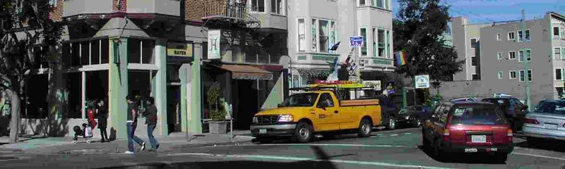
7 Embarcadero Freeway Built mid-1950s as Part of Planned Freeway along SF Waterfront Led to 1960s San Francisco Freeway Revolt Several Previous Attempts to Remove Freeway (in 1984 voters rejected demolition) TRANSform Scotland


8 Embarcadero Freeway TRANSform Scotland
9 Embarcadero: Process Environmental Groups organized quickly to demand removal Merchants Demanded Reconstruction Especially Chinatown and Fisherman s Wharf Significant Technical Debate on Repair/ Rebuild and Costs/ Timing TRANSform Scotland

10 Embarcadero: Process Sea Lion Paradox: If people could come see the Sea Lions, why couldn t they get to Chinatown and Fisherman s Wharf? Significant Discussion on Attractiveness of Chinatown and Fisherman s Wharf. TRANSform Scotland

11 Embarcadero: Process Long Political Process Decision: Replace Freeway with Extension to Planned Roadway with Historic Trolley Cars in Median Long Design Process TRANSform Scotland
12 Embarcadero: Results Economic Impacts Encouraged New Development (Including Downtown Baseball Stadium) Created Attractive Urban Place Property Values Increased Significantly Many More People Visit and Use TRANSform Scotland

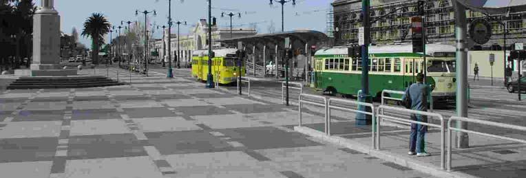

13 Embarcadero Roadway Redevelopment TRANSform Scotland


14 Embarcadero Boulevard Development TRANSform Scotland

15 Central Freeway Built mid-1950s as part of planned freeway through neighborhoods to Golden Gate Bridge Construction stopped after Freeway Revolt Huge cut destroyed neighborhood. Area rift with prostitution, drugdealing, and other antisocial behavior. TRANSform Scotland
16 Central Freeway: Process Freeway Closed Northern End Torn-Down (too damaged to repair) Significant Technical Debate on Repair/ Rebuild and Costs/ Timing Neighborhood begins to redevelop without freeway. TRANSform Scotland

17 Central Freeway: Process Neighbors organize and call for freeway demolition. Planning Process and Environmental Studies Plan for Freeway Alternatives West Side Awakens: Freeway Users Unite TRANSform Scotland


18 Central Freeway: Politics 1997: Rebuild - Passes 1998: Boulevard - Passes 1999-a: Rebuild Fails 1999-b: Boulevard Passes Much Political Intrigue Often not related to Freeway Issues at all. TRANSform Scotland
 TRANSform Scotland 4-22-2002")
19 Central Freeway: Process Octavia Boulevard Design Process Citizen Based with Expert Input Boulevard Design & Planning Finally Approved by Caltrans (2000) TRANSform Scotland


20 Central Freeway Replacement: Octavia Boulevard TRANSform Scotland
21 Central Freeway: Results Economic Impacts Encouraged New Development: Hayes Valley Housing Retail Mixed Use Created Attractive Urban Place Property Values Increased Significantly TRANSform Scotland

22 Hayes Valley Redevelopment TRANSform Scotland


23 An Aside: Traffic Reduction in Zurich Extensive Transit Priority Program Implemented 1975 to Present Significantly Improved Transit System Reduced Downtown Parking Improved Urban Design Reduced Traffic Capacity Results: Economically Vibrant and Successful Downtown TRANSform Scotland
24 Economic Impacts: Access Ability to Get Somewhere Does a path exist? (Road, Transit, Walk) What are the qualities of the travel experience? Desire to Get There Is there something worth going for? TRANSform Scotland
25 Access/Attractiveness Tradeoff When a place is attractive enough people will come no matter how hard it is to get there. They Change mode (are other modes available?) Change travel time Sea Lion Paradox TRANSform Scotland
26 But Removing the Freeway Will Cause Gridlock! San Francisco Experience: More traffic on surface streets, but no gridlock and increased retail activity. Portland Oregon: Riverfront freeway removed, improved economy. Research by Sally Cairns, C. Hass-Klau & P.B. Goodwin: Removing capacity leads to less traffic in local area. TRANSform Scotland
27 Can Changing the Transportation System Make a Place More Attractive? Yes San Francisco Development on the Waterfront and in the Hayes Valley has been Tremendous. San Francisco s Economy has not suffered from the transportation changes. TRANSform Scotland
28 Can Changing the Transportation System Make a Place More Attractive? But San Francisco had alternative transportation available: Access. San Francisco s Economy has been extremely strong and the City is a very attractive place to live: Attractiveness. TRANSform Scotland
29 Lesson 1: Public Support Message: People buy things, cars don t. Therefore economic success ultimately means focusing on access by people not cars. Show examples of successful places without freeways and heavy auto traffic. Communicate research findings such as Cairns, Hass-Klau & Goodwin. TRANSform Scotland
30 Lesson 2: Plan Carefully Alternative access is critical; is it high quality? What complimentary techniques could help increase success and public support? Traffic engineering can make or break the plan; the traffic engineer should be your friend! TRANSform Scotland
31 Lesson 3: Politics Recognize that politics will be involved and jump into the water (with the sharks). Learn how to be effective in your political environment. TRANSform Scotland
32 Lesson 4: Implement Carefully Take small steps and keep focused on the long term vision. Implement big impact projects first build support for more controversial projects. Don t unnecessarily alienate people; take street space only when you have a real use. TRANSform Scotland
33 Lesson 5: Seize Opportunities Everyone can t rely on Earthquakes, But there are other major changes that you can take advantage of, use them! Advance planning can help you take advantage of the opportunities and can help create them. TRANSform Scotland
34 Thank You! TRANSform Scotland
Reclaiming Old West Broad Street: I-16 Ramp Removal Study
 Reclaiming Old West Broad Street: I-16 Ramp Removal Study Community Meeting Summary July 15, 2014 The first community meeting for Phase II of the I-16 Ramp Removal Study was held on July 15, 2014, at the
Draft for Public Review. The Market and Octavia Neighborhood Plan
 Draft for Public Review The Market and Octavia Neighborhood Plan San Francisco Planning Department As Part of the Better Neighborhoods Program December 2002 IOverview Why Plan a Better Neighborhood Here
José Campos Manager of Planning and Design Review SPUR San José Symposium October 12, 2018
 1 Transbay: Freeways to New Ways José Campos Manager of Planning and Design Review SPUR San José Symposium October 12, 2018 2 Transbay freeway land pre-1989 3 1989 Loma Prieta Earthquake 4 TRANSBAY c.
Railyard Alternatives and I-280 Boulevard Feasibility Study. MTA Board Meeting May 6, 2014
 Railyard Alternatives and I-280 Boulevard Feasibility Study MTA Board Meeting May 6, 2014 Planned Infrastructure Major pieces of new infrastructure are planned including: Downtown Rail Extension (DTX)
Transbay Folsom Streetscape Project 2 nd Street to Spear Street Community Update July 16, 2015
 Transbay Folsom Streetscape Project 2 nd Street to Spear Street Community Update July 16, 2015 A2 Agenda Welcome and introductions Project history and goals Project overview and next steps Questions and
Making the Land Use, Transportation, Air Quality Connection
 Special Thanks To Our Generous Sponsor What Happened To Harbor Drive and the Mt. Hood Freeway? Andy Cotugno Metro Policy Advisor 180 days of air quality violations Gas Crisis Making The Pacific the Land
Stewardship. Streamlining. Consensus
 Stewardship Streamlining Consensus Translating Section 106: Building Consensus among Multiple Responsible Parties For the Doyle Drive Replacement Project in the Presidio of San Francisco National Historic
The Role of Cities in Planning Transportation Megaprojects
 The Role of Cities in Planning Transportation Megaprojects SPUR Oakland, November 28, 2018 + Elizabeth Deakin / UC Berkeley + Eric Eidlin / City of San Jose + Doug Johnson / City of San Francisco The Role
Exxon Service Station
 Exxon Service Station Environmental Impact Visual Analysis San Ramon/Blackhawk neighborhood service station. Design Community and Environment 5/97 Construction of computer models, application of material
Are we creating and exploiting synergies on our transit investments?
 10 Years of TOD in the Denver Front Range Region: Are we creating and exploiting synergies on our transit investments? Tim Van Meter Van Meter Williams Pollack Architecture & Urban Design San Francisco
A. WHAT IS A GENERAL PLAN?
 I. Introduction A. WHAT IS A GENERAL PLAN? A general plan is the planning guideline for the future of a city. It contains goals and policies which regulate urban development, the protection of the natural
Draft for Public Review. The Market and Octavia Neighborhood Plan
 Draft for Public Review The Market and Octavia Neighborhood Plan San Francisco Planning Department As Part of the Better Neighborhoods Program December 2002 . A New Neighborhood in SoMa West OBJECTIVE.1
Lake Oswego to Portland Transit Project. Lessons Learned. John Cullerton Senior Project Manager, URS 2012 APTA/TRB Light Rail Conference
 Lake Oswego to Portland Transit Project Lessons Learned John Cullerton Senior Project Manager, URS 2012 APTA/TRB Light Rail Conference Overview Project Location and Context Corridor History and Project
Making the Land Use Light Rail Connection. Andy Cotugno Metro Rail~Volution 2010
 Making the Land Use Light Rail Connection Andy Cotugno Metro Rail~Volution 2010 Making The Pacific the Land Northwest Use, Transportation, The Oregon Story "There is a shameless threat to our environment
A FREEWAY-FREE SAN FRANCISCO THE CONGRESS FOR THE NEW URBANISM
 A FREEWAY-FREE SAN FRANCISCO THE CONGRESS FOR THE NEW URBANISM ACKNOWLEDGMENTS / P4 EXECUTIVE SUMMARY / P5 INTRODUCTION / P6 Freeways in the City / P8 VANCOUVER: FREEWAY-FREE / P12 Stop the Freeway /
State Highway 121 Southwest Parkway. Fort Worth s Transportation Success Story in Design and Cooperation
 State Highway 121 Southwest Parkway Fort Worth s Transportation Success Story in Design and Cooperation Greater Fort Worth Association of Realtors October 24, 2007 Presented by: Dan Lamers, P.E. North
CENTRAL ESTUARY PLAN AVISION FOR OAKLAND S WATERFRONT
 Central Estuary Plan A VISION FOR OAKLAND S WATERFRONT Specific Plan and Environmental Assessment Presentation to the Parks and Recreation Advisory Commission December 9, 2009 This Afternoon s Presentation
Vision 2020 Economic Redevelopment Team Final Report
 Vision 2020 Economic Redevelopment Team Final Report October 24, 2011 7/30/2011 1 2020 Visioning Redevelopment Economics Team Fritz Beiermeister Mike Evangelista Bill Largent Mark Lifter Team Members Shel
Increase density to meet housing and affordability goals and to support transit investments.
 Topic Issues Community & Plan Alternatives Ideas Built Environment 1 - Adapt and grow downtown's capacity for a vibrant mix of jobs, housing and other uses to meet the needs of existing residents and the
Visual and Aesthetics
 Such a connection could accommodate timed transfers and improve connections between local transit service and Presidio Shuttle service. Level of Service The results of the analysis are provided on a route-by-route
TOWN COUNCIL / PLANNING COMMISSION
 Workshop #3 TOWN COUNCIL / PLANNING COMMISSION January 20, 2011 Consultant Team In Attendance Tonight BMS Design Group Nevada City and San Francisco Michael Smiley, AICP, ASLA Partner-in-Charge Nancy L.
FACILITY REPORT - LIVERMORE VAULT
 FACILITY REPORT - LIVERMORE VAULT INTRODUCTION The Ship Art Vault facility located in Livermore California is the product of years of research and development into creating the best possible Fine Arts
ITEM #8. Regional Smart Growth Program. Regional Smart Growth Program. Presentation Overview. Coast Highway Vision and Stategic Plan.
 Regional Smart Growth Program Economic Development Commission What is Smart Growth? Adopted as part of the Regional Comprehensive Plan (RCP) RCP provides vision for region based on Smart Growth and sustainability
Development Agreement Public Meeting. June 26, 2013
 Development Agreement Public Meeting June 26, 2013 Process 2007 2008 2009 2010 2011 2012 2013 Neighborhood Conservation District Petition Process Original Master Plan presented Community Forum Glen Lennox
PORT OF SAN FRANCISCO
 PORT OF SAN FRANCISCO WATERFRONT LAND USE PLAN Prop H (1990) required a Waterfront Land Use Plan Port property in BCDC jurisdiction Define Acceptable Uses Hotels prohibited on piers Prioritize Maritime
PROJECTS AND THE PUBLIC ART MASTER PLAN
 MEMO TO: PUBLIC ART STEERING COMMITTEE MEMBERS FROM: SHARI COOPER, DEVELOPMENT PROJECT COORDINATOR DATE: FEBRUARY 24, 2017 SUBJECT: AGENDA ITEM 5.A: PUBLIC ART PROJECT FOR 2017-18 BACKGROUND One of the
CHAPTER 1. Ms. Guajardo s Class - Central Elementary CH 1 1
 INTRODUCTION CHAPTER 1 Ms. Guajardo s Class - Central Elementary CH 1 1 1.1 SETTING South Centre City is a linear corridor south of Downtown Escondido paralleling Centre City Parkway and South Escondido
Chapter 4. Linking Land Use with Transportation. Chapter 4
 Chapter 4 Linking Land Use with Transportation Chapter 4 59 Chapter 4 Linking Land Use with Transportation Community Design and Transportation Program Introduction Since the 1950s, the predominant development
TREASURE ISLAND PHASE ONE PROJECTS PUBLIC ART PROJECT OUTLINE
 TREASURE ISLAND PHASE ONE PROJECTS PUBLIC ART PROJECT OUTLINE BACKGROUND (DEVELOPMENT PROJECT OVERVIEW) The Treasure Island Development is an approved 405-acre redevelopment project on Treasure Island
Route 9 Gateway Project. October 9, 2014 Informational Meeting
 Route 9 Gateway Project NYS DOT P.I.N. 1759.67 Town of Lake George, New York October 9, 2014 Informational Meeting Open House 3:00-3:30 Presentation 3:30-4:15 Introductions Town Representatives Dennis
Public input has been an important part of the plan development process.
 Lakewood s Comprehensive Plan recognizes that transportation helps shape the community, and that the way the community provides for the safe and efficient movement of people affects the character of the
Taming Tysons Corner Transforming the Quintessential Edge City
 Taming Tysons Corner Transforming the Quintessential Edge City Transit is the greatest catalyst for change at Tysons, but how do we take advantage of this billion-dollar investment? If transit is built
City of Hermosa Beach Administrative Policy #
 City of Hermosa Beach Administrative Policy # SUBJECT: Living Streets Policy Date: Approved by: City Council Authority: Public Works Department & Community Development Department Mayor, PURPOSE The City
Table of Contents. Executive Summary... vii
 Table of Contents Executive Summary... vii Section I: Background...1 Introduction... 3 Study History... 3 Purpose and Role of the Plan... 6 Plan Organization... 7 The Estuary Shoreline... 11 Multiple Jurisdictions...
Peter Finley FRY. Land Use Planning & Design Consultant. Peter Finley Fry AICP. Portland, USA PORTLAND, OREGON STRATEGIES OF GROWTH MANAGEMENT
 23 26 JUNE 202 Peter Finley FRY Land Use Planning & Design Consultant Peter Finley Fry AICP Portland, USA PORTLAND, OREGON STRATEGIES OF GROWTH MANAGEMENT PORTLAND, OREGON STRATEGIES OF GROWTH MANAGEMENT
Illustrative Development Plan
 Illustrative Development Plan December 7, 005 045 Sansome St., Studio 3 San Francisco, CA 94 Area A - Increase visibility to waterfront and aquatic center from the Embarcadero - Provide streets rather
Affordability & Equity
 Affordability & Equity 1. Impact Fees 2. Displacement Prevention- build more housing to meet growth demands 3. Density Bonuses 4. Regional Housing Bond 5. Stricter Condominium Conversion Laws 6. Vacant
ECR. el camino real master plan. settings and opportunities. The City of San Mateo SMWM. Adopted by the San Mateo City Council September 18, 2001
 ECR el camino real master plan settings and opportunities Adopted by the San Mateo City Council September 18, 2001 The City of San Mateo SMWM el camino real master plan settings and opportunities 1 executive
SLIDE TITLE. TRANSIT AGENCIES AND COMMUNITY PLANNING Case Study in Supporting TOD with the Chicago Transit Authority TRANSPORT CHICAGO 2017
 SLIDE TITLE TRANSIT AGENCIES AND COMMUNITY PLANNING Case Study in Supporting TOD with the Chicago Transit Authority 1 INTRODUCTION WELCOME Steve Hands, Senior Manager for the Chicago Transit Authority
40 Years of Smart Growth Arlington County s Experience with Transit Oriented Development in the Rosslyn-Ballston Metro Corridor
 40 Years of Smart Growth Arlington County s Experience with Transit Oriented Development in the Rosslyn-Ballston Metro Corridor A presentation by the Arlington County Department of Community Planning,
Initiative 123. Alaskan Way Elevated Park + other amenities. voteyeson123.org
 Initiative 123 Alaskan Way Elevated Park + other amenities voteyeson123.org SDOT has a plan for the downtown waterfront, but the plan doesn t create value, beauty or public benefit and it doesn t leverage
LANGAN QUALIFICATIONS FOR THE MORGAN COMPANIES
 LANGAN QUALIFICATIONS FOR THE MORGAN COMPANIES CONTACT Arlington Virginia 1300 Wilson Boulevard Suite 450 Arlington VA 22209-2323 571.366.6800 571.366.6801 CONTACT Louise Pretzman 571.366.6826 lpretzman@langan.com
Fisherman s Wharf Public Realm Plan
 Fisherman s Wharf Public Realm Plan SPUR Presentation July 11, 2008 3 February 2010 WHY A PUBLIC REALM PLAN? Public Life 1900 1950 1965 2000 Mainstreet Copenhagen in 100 years From nessesary to optional
Factors Affecting the Shape of California Cities
 Factors Affecting the Shape of California Cities Hercules? Where? Form-Based Codes: A Planning Tool for Healthier Communities Modesto, August 27, 2009 Stephen Lawton Economic Development Director City
IDENTIFICATION TO IMPLEMENTATION THE JOURNEY OF CITY RESILIENCE
 IDENTIFICATION TO IMPLEMENTATION THE JOURNEY OF CITY RESILIENCE Cities are dynamic, living and growing entities. They are centers of art, heritage and cultural pride and their vibrancy attracts visitors,
Streets, Connectivity & Built Environment Working Group August 2, 2017
 Streets, Connectivity & Built Environment Working Group August 2, 2017 DOWNTOWN OAKLAND SPECIFIC PLAN WELCOME Streets, Connectivity & Built Environment Working Group Social Equity Meeting August 2, 2017
Jordan Harrison, Planner III, San Francisco Recreation and Park Department
 Date December 8, 2015 To: Through: From: Subject: Recreation and Park Commission Philip A. Ginsburg, General Manager Dawn Kamalanathan, Director, Capital & Planning Division Jordan Harrison, Planner III,
DRAFT Land Use Chapter
 Stevens Creek Urban Village DRAFT 1 18 17 Land Use Chapter INTRODUCTION This Land Use Chapter describes how the Stevens Creek Urban Village will accommodate the growth that is planned for it in the Envision
Better Market Street. Presentation to the SFMTA Board of Directors June 19, 2012
 Better Market Street Presentation to the SFMTA Board of Directors June 19, 2012 Project Goal: Project Goal Revitalize Market Street from Octavia Boulevard to The Embarcadero and reestablish the street
Creating Complete Roadway Corridors:
 Creating Complete Roadway Corridors: The AASHTO Guide to Transportation Landscape Architecture and Environmental Design NCHRP Project 15-33 Status Report AASHTO Standing Committee on Design Technical Committee
PORT OF SAN FRANCISCO WATERFRONT PLAN UPDATE: PART 3
 Waterfront Planning Timeline WHAT IS THE PORT? The Port of San Francisco manages 7½ miles of the San Francisco waterfront from Fisherman s Wharf in the north to Heron s Head Park in the south. Port properties
Summary Community Workshop #6 Beacon Day School Saturday, November 14, :00 a.m. 12:00 p.m.
 Summary Community Workshop #6 Beacon Day School Saturday, November 14, 2009 9:00 a.m. 12:00 p.m. Workshop Format and Process The City of Oakland is preparing a Specific Plan that will help define and determine
Proposed Comprehensive Plan Strategies DRAFT for discussion June 28, 2017
 Proposed Comprehensive Plan Strategies DRAFT for discussion June 28, 2017 Land Use Rural Areas Refine the Farm and Forest area (FF) Update FF boundaries to account for existing lots less than five acres
CITYWIDE PLANNING DIVISION
 2014-2019 CITYWIDE PLANNING DIVISION a five-year work program for long-range planning November 2016 TODAY S PRESENTATION 1. Overview 2. Planning Priorities 3. Topics/Focus Areas 5. Essential Practices
Port Lavaca Future Land Use
 Port Lavaca Future Land Use Introduction The City of Port Lavaca is beginning to see sustained growth, after many years of relative stable population. New single family homes, apartments, and businesses
Land Use Planning in the United States and in Oregon
 Land Use Planning in the United States and in Oregon Dr. Ethan Seltzer Nohad A. Toulan School of Urban Studies and Planning Portland State University Outline Planning in the United States Planning In Oregon
EXHIBIT A. Tax Increment Reinvestment Zone No. 1 (Town Center) First Amended Project Plan 1
 First Amended Project Plan 1") EXHIBIT A Tax Increment Reinvestment Zone No. 1 (Town Center) First Amended Project Plan 1 1 As amended by Resolution No. 2008-02-001(TR1R) of the Tax Increment Reinvestment Zone No.1, and approved to
EXHIBIT A Tax Increment Reinvestment Zone No. 1 (Town Center) First Amended Project Plan 1 1 As amended by Resolution No. 2008-02-001(TR1R) of the Tax Increment Reinvestment Zone No.1, and approved to
M i s s i o n B a y W a t e r f r o n t
 114 M i s s i o n B a y W a t e r f r o n t Character of the Area: The Mission Bay Waterfront extends from Pier 48 at China Basin Channel to 18th Street in the Central Basin. This area of the waterfront
International Blvd. TOD Plan Public Workshop #1
 International Blvd. TOD Plan Public Workshop #1 Add photos or project images September 21 and 22, 2010 Workshop Purpose Introduce the public to the Project Review and discuss the existing conditions analysis
Project Schedule. = Council/Commission Meeting. = Community Workshop. Administrative Draft Specific Plan. Draft Existing Conditions Report
 Project Schedule 2016 2017 Draft Existing Conditions Report Administrative Draft Specific Plan Public Review Draft Specific Plan Community Involvement Plan Alternatives Preferred Alternative and Design
4.8 LAND USE AND PLANNING
 4.8 LAND USE AND PLANNING 4.8.1 INTRODUCTION This section describes existing and planned land uses at the Hayward campus and analyzes the impact of implementation of the proposed Master Plan on land uses
Animating the Rideau Canal December 2013
 Executive Summary Animating the Rideau Canal December 2013 Why study the Rideau Canal? The Rideau Canal has been an important part of Ottawa throughout its history, and has shaped and been shaped by the
1. PLANNING CONCEPTS. Central Petaluma Specific Plan Chapter 1. Planning Concepts Page 7
 Page 7 1. PLANNING CONCEPTS Overview of Planning Concepts The plan for Central Petaluma envisions a reinvigorated central district that accommodates a greater diversity and intensity of activities, including
San Diego River Coalition 2012 Work Plan
 San Diego River Coalition 2012 Work Plan Adopted November 18, 2011 The mission of the San Diego River Coalition is preserve and enhance the San Diego River, its watershed, and its natural, cultural and
July 12, Columbus City Council City Hall 90 West Broad Street Columbus, OH RE: I-70/71 Columbus Crossroads Project
 OHIO DEPARTMENT OF TRANSPORTATION DISTRICT 6 400 EAST WILLIAM STREET DELAWARE, OHIO 43015 800.372.7714 Columbus City Council City Hall 90 West Broad Street Columbus, OH 43215-9015 RE: I-70/71 Columbus
Summary Community Workshop #1 Fruitvale San Antonio Senior Center Monday, March 23, :00-9:00 p.m.
 Summary Community Workshop #1 Fruitvale San Antonio Senior Center Monday, March 23, 2009 7:00-9:00 p.m. Workshop Format and Process The City of Oakland is preparing a Specific Plan that will help define
SAN FRANCISCO URBAN DESIGN GUIDELINES
 SAN FRANCISCO URBAN DESIGN GUIDELINES Planning Commission Informational 20 October 2016 WHAT ARE DESIGN GUIDELINES? Design Guidelines are implementation documents for city design policies and objectives.
Senator Sieben SF Representative Schoen HF Presentation Guide
 Senator Sieben SF 1179 Representative Schoen HF 1374 Presentation Guide Appearance Transportation and Public Safety, Room 15 of the Capitol. 3-5:30 PM on Wednesday, March 13 Speakers Honorable Senator
EXISTING COMPREHENSIVE PLAN
 EXISTING COMPREHENSIVE PLAN Town Center Land Use Element: V. LAND USE POLICIES Town Center Mercer Island's business district vision as described in "Your Mercer Island Citizen-Designed Downtown" was an
WEST OAKLAND SPECIFIC PLAN & DRAFT ENVIRONMENTAL IMPACT REPORT
 WEST OAKLAND SPECIFIC PLAN & DRAFT ENVIRONMENTAL IMPACT REPORT Landmarks Preservation Advisory Board Public Hearing February 10, 2014 1 Specific Plan Overview Plan Area is generally bounded by I-580 to
Q:%4~ Memorandum CITY OF DALLAS
 Memorandum DATE December 10, 2010 CITY OF DALLAS TO Members of the Transportation and Environment Committee: Linda Koop (Chair), Sheflie Kadane (Vice Chair), Pauline Medrano, Vonciel Jones Hill, Jerry
City of Toronto Official Plan Indicators
 City of Toronto Official Plan Indicators Attachment 1 2017 Gladki Planning Associates in association with Hemson Consulting & Studio Jaywall City of Toronto Official Plan Indicators 1 Introduction What
40 Years of Smart Growth Arlington County s Experience with Transit Oriented Development in the Rosslyn-Ballston Metro Corridor
 40 Years of Smart Growth Arlington County s Experience with Transit Oriented Development in the Rosslyn-Ballston Metro Corridor A presentation by the Arlington County Department of Community Planning,
City of Walnut Creek. North Downtown. Specific Plan Process. Community Advisory Committee: Meeting #3. September 26, 2016
 City of Walnut Creek North Downtown Specific Plan Process Community Advisory Committee: Meeting #3 September 26, 2016 Introduction Where we are in the process City showcase in August We ve started existing
2 Transbay Streetscape & Open Space Concept Plan
 2 Transbay Streetscape & Open Space Concept Plan 1 TRANSBAY REDEVELOPMENT PROJECT AREA DESIGN FOR DEVELOPMENT San Francisco Redevelopment Agency & San Francisco Planning Department Skidmore, Owings & Merrill
The Lincoln Neighborhood Corridor Plan. The LiNC
 October 1, 2014 Planning Commission Study Session The Lincoln Neighborhood Corridor Plan The LiNC Purpose of Tonight s Meeting Introduction to The LiNC Review of Existing Conditions and Community Identified
Concord Community Reuse Project Goals and Guiding Principles. Overarching Goals (OG)
") Concord Community Reuse Project Goals and Guiding Principles Overarching Goals (OG) No priority is implied by the order of presentation of the goals and guiding principles. Overarching goals for the Concord
Concord Community Reuse Project Goals and Guiding Principles Overarching Goals (OG) No priority is implied by the order of presentation of the goals and guiding principles. Overarching goals for the Concord
WHITE FLINT SECTOR PLAN PHASE I PRESENTATION Montgomery County Planning Board April 13, Luxmanor Citizens Association
 WHITE FLINT SECTOR PLAN PHASE I PRESENTATION Montgomery County Planning Board April 13, 2009 Luxmanor Citizens Association An Inclusive Master Plan The Vision of a Better Community Pedestrian oriented
THE GAS PLANT DISTRICT MASTER PLAN SCENARIO 2. COMMUNITY MEETING August 6, 2018
 THE GAS PLANT DISTRICT MASTER PLAN SCENARIO 2 COMMUNITY MEETING August 6, 2018 The Gas Plant Neighborhood in the 1970 s The development should honor the history of the Gas Plant neighborhood and the community
CITY OF ANN ARBOR MASTER PLAN. Land Use Element
 CTY OF ANN ARBOR MASTER PLAN Land Use Element June 15, 2009 Prepared by the Ann Arbor City Planning and Development Services Unit and the City of Ann Arbor Planning Commission City Master Plan: Land Use
Case Studies of Urban Freeways for The I-81 Challenge
 Case Studies of Urban Freeways for The I-81 Challenge Syracuse Metropolitan Transportation Council February 2010 Table of Contents OVERVIEW...2 Lessons from the Case Studies...4 Success Stories...6 Case
THREE ADJACENT COMMERCIAL PARCELS FOR SALE IN DOWNTOWN DAVIS OLIVE DAVIS, CA RICHARDS BLVD
 THREE ADJACENT COMMERCIAL PARCELS FOR SALE IN DOWNTOWN DAVIS 1031-41 DAVIS, CA RICHARDS BLVD Section One: The Property PRIME DEVELOPMENT OPPORTUNITY IN DAVIS Property One* Rent: $1,225 / Mo 1031 Olive
Corridor Vision. 1Pursue Minnehaha-Hiawatha Community Works Project. Mission of Hennepin County Community Works Program
 1Pursue Minnehaha-Hiawatha Community Works Project Minnehaha-Hiawatha Community Works is a project within the Hennepin Community Works (HCW) program. The mission of the HCW program is to enhance how the
NOTICE OF PREPARATION
 NOTICE OF PREPARATION To: All Interested Parties Subject: Notice of Preparation of an Environmental Impact Report From: City of Petaluma Address: 11 English Street, Petaluma, CA 94952-2610 Contact: Heather
Project Profile BAR HARBOR
 1 BAR HARBOR The Bar Harbor Master Plan merges community vision with design guidelines to preserve the unique character of Bar Harbor Village. PROJECT SUMMARY Overview: The economic vitality of Bar Harbor
Workshop. Valley Vision Stanislaus. Our Schedule. Help Shape Our Region s Future! The Scenarios. Who is StanCOG? How Do I Select a Scenario?
 Valley Vision Stanislaus Workshop Help Shape Our Region s Future! Valley Vision Stanislaus is a long-range planning process that will link future land use with a framework for investment in roads, freeways,
RESILIENT COMMUNITIES PROJECT CITY OF MINNETONKA
 RESILIENT COMMUNITIES PROJECT CITY OF MINNETONKA BUILDING COMMUNITY-UNIVERSITY PARTNERSHIPS FOR SUSTAINABILITY Presentation to The League of Women Voters March 16, 2013 Julie Wischnack, Community Development
A Plan for the Heart of the Region: Tukwila, WA
 : Tukwila, WA 1 The Plan orchestrates the Restructuring of a 1,000-acre Regional Shopping Area into a Social and Symbolic for the Region. REGIONAL CONTEXT Downtown Seattle (Metropolitan ) 20 miles Bellevue
EXECUTIVE SUMMARY EXECUTIVE SUMMARY
 1 EXECUTIVE SUMMARY EXECUTIVE SUMMARY Penn s Landing is envisioned as a welcoming riverfront green space adjacent to a refurbished civic marina becoming the centerpiece for adjacent development. With a
Public Meeting #3 May 9, 2009 MVVA Team
 Public Meeting #3 May 9, 2009 MVVA Team Welcome to the third Public Meeting for the Lower Don Lands Municipal Class Environmental Assessment (EA) Infrastructure Master Plan and Keating Channel Precinct
Purpose of Open House #3
 Public Meeting #3 May 9, 2009 MVVA Team Purpose of Open House #3 The main purpose of this Open House is to present and seek input on the: Evaluation of transportation and infrastructure design alternatives
Tacoma Mall Neighborhood Subarea Plan & EIS. Planning Commission January 18, 2017
 Tacoma Mall Neighborhood Subarea Plan & EIS Planning Commission January 18, 2017 Objectives Develop one or more options for connectivity requirement What is the intent? Key considerations Range of options
ULI PLACEMAKING OBJECTIVES
 ULI PLACEMAKING OBJECTIVES I) What is considered Great Placemaking and why? - Visual examples of New large scale projects with critical mass - Visual examples of Redevelopment smaller scale Main Street
WEST OAKLAND SPECIFIC PLAN PROJECT DESCRIPTION
 WEST OAKLAND SPECIFIC PLAN PROJECT DESCRIPTION INTRODUCTION The West Oakland Specific Plan will guide future development in West Oakland. The purpose of the proposed West Oakland Specific Plan is to provide
Urban Form Case Studies
 Urban Form Case Studies Elana Horowitz Ontario Growth Secretariat Ministry of Energy and Infrastructure MINISTRY OF ENERGY AND INFRASTRUCTURE 1 Presentation Structure Role of the Ontario Growth Secretariat
FINAL WEST OAKLAND SPECIFIC PLAN & FINAL ENVIRONMENTAL IMPACT REPORT
 1 FINAL WEST OAKLAND SPECIFIC PLAN & FINAL ENVIRONMENTAL IMPACT REPORT Landmarks Preservation Advisory Board Public Hearing June 9, 2014 2 Purpose of LPAB public hearing Provide cultural-resource related
The Five Components of the McLoughlin Area Plan
 The Five Components of the McLoughlin Area Plan This documents contains the complete language of the five components of the McLoughlin Area Plan: The Vision Statement The Values The Guiding Principles
SPRINGFIELD, MA Technical Assistance Panel (TAP)
") SPRINGFIELD, MA Technical Assistance Panel (TAP) ULI the Urban Land Institute Mission To provide leadership in the responsible use of land and in creating and sustaining thriving communities worldwide.
SPRINGFIELD, MA Technical Assistance Panel (TAP) ULI the Urban Land Institute Mission To provide leadership in the responsible use of land and in creating and sustaining thriving communities worldwide.
Attachment B Summary of Plan Alternatives Report
 Attachment B Summary of Plan Alternatives Report Based on community ideas and feedback to date, a series of draft alternative scenarios for the future of downtown s neighborhood districts have been created
Boster, Kobayashi & Associates 59 Rickenbacker Circle Office: (925) P.O. Box 2049 Fax: (925) Livermore, CA
 P.O. Box 2049 Fax: (925) Livermore, CA") Boster, Kobayashi & Associates 59 Rickenbacker Circle Office: (925) 447-6495 P.O. Box 2049 Fax: (925) 447-6589 Livermore, CA 94551-2049 RICHARD K. HAYGOOD, P.E. Curriculum Vitae EDUCATION: M.B.A. UCLA
Boster, Kobayashi & Associates 59 Rickenbacker Circle Office: (925) 447-6495 P.O. Box 2049 Fax: (925) 447-6589 Livermore, CA 94551-2049 RICHARD K. HAYGOOD, P.E. Curriculum Vitae EDUCATION: M.B.A. UCLA