MERIDAN PLAINS SAND RESOURCE AREA
|
|
|
- Arlene Dalton
- 5 years ago
- Views:
Transcription
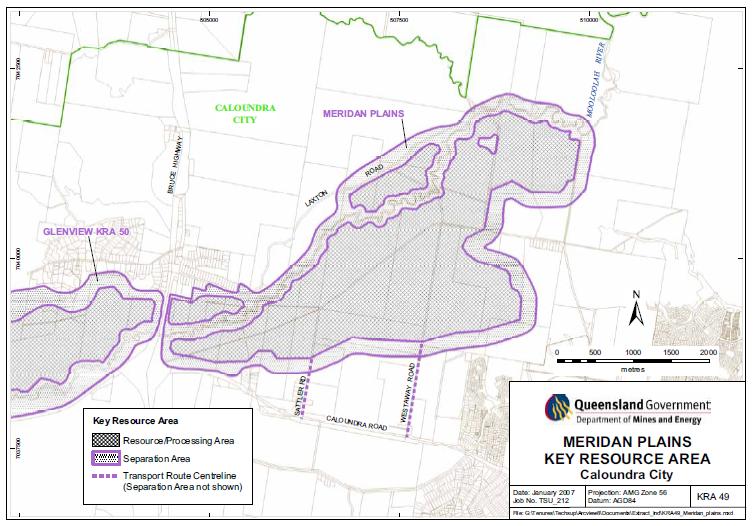
1 MERIDAN PLAINS SAND RESOURCE AREA INFORMATION SHEET October 2010 BACKGROUND The Meridan Plains Extractive Resource Area is located on the western fringe of the coastal urban communities of Caloundra West and Kawana Forest. The Area is situated just south of the proposed future Greenfield Major Development Area of Palmview and the existing urban community of Sippy Downs. The Area is generally bound by Caloundra Road to the south, the Bruce Highway to the west, Laxton Road to the north and Meridan Way in the east and is estimated to be 1095 hectares in size (which is made up of approximately 714 hectares of potential extraction area and 381 hectares of proposed separation/buffer area). The Meridan Plains Extractive Resource Area is identified as Key Resource Area 49 (KRA 49) for the extraction of fine to coarse-grained sand under State Planning Policy 2/07 Protection of Extractive Resources. (See attached map) The South East Queensland (SEQ) Regional Plan also identifies and protects the Mooloolah River floodplain for extractive resources. The KRA is recognised and protected under Caloundra City Plan 2004 as an Extractive Resource Area but was not intended to be exploited during the life of the Caloundra City Plan 2004, so as to enable resolution of long term land use strategies for the area. Caloundra City Council on 7 December 2006, resolved to proceed to undertake investigations in relation to the Meridan Plains Extractive Resource Area, subject to the resolution of cost recovery arrangements with landowners and other interested stakeholders within the Meridan Plains Extractive Resource Area, in accordance with the Council s Policy Statement No. 769 Cost Recovery Arrangements for the Supply of Planning Services in respect of the Meridan Plains Extractive Resource Area. Caloundra Council drafted a planning scheme amendment (Amendment 3C to Caloundra City Plan 2004) to facilitate appropriate development of KRA 49. Prior to drafting the planning scheme amendment, Caloundra Council arranged for landowners within the KRA to contribute funds towards targeted preliminary investigations. These investigations informed the preparation of the draft planning scheme amendment. The draft amendments were considered by the state government before public notification occurred. The Sunshine Coast Regional Council publicly notified the amendment during March to May Council received and considered 15 submissions from the community. On 10 December 2009, Council resolved to forward the draft amendments to the Caloundra City Plan in relation to Meridan Plains Extractive Resource Area (as amended after considering public submissions) to the Minister for Infrastructure and Planning for final consideration of state interests. Council has received the final
2 response from the Minister to proceed to adoption of the draft amendments, subject to conditions. These amendments and a Council resolution dated 10 December 2009 required the preparation of a lake management plan, landform design and site rehabilitation plan and a site management plan. This resolution also identified the need for a funding group to be established in order to determine a funding model for the establishment of further investigative studies. FREQUENTLY ASKED QUESTIONS 1. Why does sand need to be extracted from this area? South East Queensland is in short supply of this resource, given the high rates of growth occurring in the region. This resource will supply the greater Sunshine Coast Area for up to years. The extent of the resource exploited and the end use will be carefully considered, given the sites proximity to urban areas. 2. Meridan Plains is close to residential areas is it suitable for this purpose? The Department of Mines and Energy identified the Meridan Plains Extractive Resource Area (MPERA) as a significant sand resource for South East Queensland. The department concluded the use could likely co-exist with nearby existing and future residential development. 3. Will there be effects on local residents from noise, dust, transport trucks or other activities at the extraction site? Extraction and washing of sand is generally a wet process, with little opportunities for dust resulting from this process. Each approval for sand extraction will have conditions relevant to the Environmentally Relevant Activity (ERA) and council conditions will mitigate potential airborne particulates from quarry activities, on site and along haulage routes. This will include the implementation of a site-based dust management plan that will include the covering of trucks during transportation and water trucks to wet the roads. Extraction areas are limited to small areas within the site at any one time, combined with progressive land rehabilitation through the implementation of a site rehabilitation and landform design plan. The development includes the provision of visual/vegetation buffers, a total area of 381 hectares. 4. How far away is the closest residence to the resource area? The closest residence (south of resource area) is approximately 100 metres from the edge of the resource boundary. Other residences are located between 100 metres and over 1 km away. The location of the residences to the resource does not mean that they will be located within that distance, to the activity. It is expected the first activity will commence nearer the middle of the site, where this nearest residence is approximately 690 metres away from any initial activity (located north, north-west of resource area). See attached map Distances to Residences. 5. What public consultation has been undertaken for this proposal? Public consultation occurred as part of the process of amending Caloundra City Plan The draft planning scheme amendments were placed on public display from 30 March 2009 to 15 May 2009 in accordance with Schedule 1 of the repealed Integrated Planning Act A total of 15 submissions were received in response. 2 of 5
3 6. Is the Meridan Plains Extractive Resource Area recognised within the SEQ Regional Plan? The Meridan Plains Extractive Resource Area was identified as a significant extractive resource in the former 2005 version of the SEQ Regional Plan and this status has remained unchanged in the current version of the Plan, referred to as Map 8 Rural Production and Natural Resources. The site is located within the Regional Landscape and Rural Production Area. 7. What is the nature of draft planning scheme amendments relating to Meridan Plains Extractive Resource Area? Council Officers will seek Council adoption of draft scheme amendments, providing Council agrees with the funding strategy. A summary of the draft Planning Scheme amendments are as follows: Amendments to the Mooloolah Valley Planning Area Code to provide for extractive industry to occur within the Meridan Plains Extractive Resource Area during the life of the Planning Scheme. Amendments to the Development Assessment Tables to make extractive industry code assessable within the Meridan Plains Extractive Resource Area. Code assessable applications are not publicly notified. Amendments to the Extractive Industry Code to include a new section relating specifically to development in the Meridan Plains. New specific outcomes relating to Master Planning & Development Principles, and Site Management. New maps that refine the potential extractive outcomes for the KRA. 8. Have studies been undertaken to determine what impacts may occur on the local environment? In 2007/2008 select investigative studies were undertaken to inform the preparation of the amendments to Caloundra City Plan Further studies are required as determined by the planning scheme amendments and Council resolution OM09/378, 10 December This resolution required the identification of a funding strategy that enables the development of the Lake Management Plan, Final Landform Design and Site Rehabilitation Plan. 9. What will be the size and duration of the project? The potential extraction area is 714 hectares with 381 hectares of proposed separation/buffer area. There is approximately 100 million tonnes of fine to coarse-grained alluvial sand with an average thickness of 10 metres, with overburden ranging from 0.5 metres to 7 metres in depth. Potential extraction activities may extend up to and beyond 60 years, depending on demand. 10. Are there any approvals over the site and what process is required for development applications? Council has received an impact assessable application for development of Lot 4 RP (application number 2009/ ). This site is approximately 30 hectares in size. Information regarding this application can be accessed via PD on line at Council s website. Once the planning scheme amendments are adopted, all applications will be code assessable, provided they comply with the applicable codes in Caloundra City Plan What degree of vegetation is to be lost in the development of this site? Most of the vegetation in the Key Resource Area is located adjacent to Mooloolah River and will be retained within a 60 metre buffer area. All other vegetation that is considered significant (south eastern corner and small section within north- 3 of 5
4 eastern portion of the site) will be retained and protected by a 50 metre buffer. In other parts of the site, there is minimal vegetation, due to past cane growing and grazing activity. Extraction activities are limited to small areas within the site at any one time and are combined with progressive land rehabilitation through the implementation of a site rehabilitation and landform design plan. 12. What will be the route followed by trucks transporting sand? The haulage route will utilise Sattler Road and Westaway Road, connecting directly to Caloundra Road. 13. Is this site to be used for sand mining? The proposed sand extraction activities involve the wet extraction and processing (generally screening and washing) of sand. This activity retains the physical properties of the sand. Sand mining on the other hand, goes through a process in which the physical properties of the sand are changed (foundry purposes eg. sand casting). The sand properties within the Meridan Plains Extractive Resource Area are suitable for, and will generally be utilised in its natural form for construction purposes (eg. concrete). 14. Is the generation of silica dust likely? The generation of silica dust is unlikely due to the nature of the wet removal and processing of the sand (see response to Q.3). Development approval under the Sustainable Planning Act 2009 and Environmental Protection Act 1994 requires that any person carrying out an environmentally relevant activity (ERA) must hold, or be acting under, a registration certificate for that activity. This activity will be subject to ERA conditions and relevant Council conditions. An Environment Management Plan (including an air quality management plan) is required for such activity and provides the framework for environmental management on the site and is a practical guide at the operational level to contain environmental impacts. MERIDAN PLAINS KEY RESOURCE AREA MAP The attached map identifies the extent of KRA 49. The details of the map illustrate the Resource/Processing Area, the Separation Area (buffers) and Transport Routes. In the near future Council will further consider a planning scheme amendment map that refines the potential extraction outcomes for the KRA. The map will be publicly released after Council has made its decision. 4 of 5
5
Local Area Key Issues Paper No. 11: Extractive industry - Yandina Creek and Browns Creek Road
 Draft Sunshine Coast Planning Scheme Review of Submissions Local Area Key Issues Paper No. 11: Extractive industry - Yandina Creek and Browns Creek Road Key Issue: No. of submissions: Sites identified
9.3.7 Extractive industry code
 9.3.7 Extractive industry code 9.3.7.1 Application (1) This code applies to assessable development identified as requiring assessment against the Extractive industry code by the tables of assessment in
Proposed Amendments to Sunshine Coast Planning Scheme 2014 Review of Submissions Key Issues Discussion Paper. Palmview
 Proposed Amendments to Sunshine Coast Planning Scheme 2014 Review of Submissions Key Issues Discussion Paper. Palmview Key Issue: No. of submissions: Amendments to Palmview Structure Plan 155 submissions
Amendments to the Palmview Structure Plan (amended text)
") Appendix A Amendments to the Palmview Structure Plan (amended text) Part 10 Other Plans 10.3 Palmview Structure Plan 10.3.1 Preliminary 10.3.1.1 Introduction This Part comprises the Palmview Structure
Appendix A Amendments to the Palmview Structure Plan (amended text) Part 10 Other Plans 10.3 Palmview Structure Plan 10.3.1 Preliminary 10.3.1.1 Introduction This Part comprises the Palmview Structure
Part 10 Other plans
 Contents of Part 10 Part 10 Other plans... 10-1 10.1 Preliminary... 10-1 10.2 Palmview Structure Plan... 10-2 10.2.1 Preliminary... 10-2 10.2.2 Master Strategic Framework... 10-6 10.2.3 Master Precincts
Planning Proposal Charlestown Swim and Leisure Centre LEP Amendment
 Planning Proposal Charlestown Swim and Leisure Centre LEP Amendment Amendment No. 4 to Lake Macquarie Local Environmental Plan 2014 (PP_2014_LAKEM_005_00) Local Government Area: Name of Draft LEP: Lake
NON-TECHNICAL SUMMARY
 Proposed Sand and Gravel Extraction and Associated Processing Operations with Restoration to a Mixture of Agriculture and Nature Conservation including Areas of Shallow Water at Hedgeley, Northumberland
Town and Country Planning (Environmental Impact Assessment Regulations) 2011 SCOPING OPINION
 2011 SCOPING OPINION") Town and Country Planning (Environmental Impact Assessment Regulations) 2011 SCOPING OPINION Application Site and Description of Development Proposed new quarry at Culham, Oxfordshire Land and Mineral
Town and Country Planning (Environmental Impact Assessment Regulations) 2011 SCOPING OPINION Application Site and Description of Development Proposed new quarry at Culham, Oxfordshire Land and Mineral
APPENDIX K. Visual Impact Assessment
 APPENDIX K Visual Impact Assessment Integra Open Cut Project VISUAL IMPACT ASSESSMENT Prepared for URS Australia Pty Ltd 3 rd December 2008 GREEN BEAN DESIGN l a n d s c a p e a r c h I t e c t s GREEN
PANSHANGER QUARRY, Hertfordshire
 PANSHANGER QUARRY, Hertfordshire Proposed enhanced restoration of Phases F & H Briefing Note 1 March 2015 INERT (INACTIVE) RESTORATION MATERIALS, CONTROLS AND OPERATIONS 1 Introduction This briefing note
Planning Proposal under section 55 of the EP&A Act
 FOR PUBLIC EXHIBITION [Brief description] Monday 10 October to Monday 27 October 2014 Planning Proposal under section 55 of the EP&A Act Port Macquarie-Hastings LEP 2011 (Amendment No 32) Mixed land zone
Lake Macquarie City. A copy of the published amendment including the instrument and maps, is provided in Attachment 7 of this report.
 Planning Proposal Amendment No. 77 to Lake Macquarie Local Environmental Plan 2004 and proposed Amendment to Draft Lake Macquarie Local Environmental Plan 2013 Minor Zone Boundary Adjustment - Pasminco
Managing Fire Risk for New Rural Dwellings
 Managing Fire Risk for New Rural Dwellings Policy Options Paper Draft Proposed Changes to the Tasman Resource Management Plan For Public Consultation December 2011 January 2012 Executive Summary The current
BREEDON NORTHERN LIMITED
 Non Technical Summary CONTENTS 1 INTRODUCTION... 1 2 SITE DESCRIPTION... 1 3 DESCRIPTION OF THE DEVELOPMENT... 6 4 NEED FOR THE DEVELOPMENT... 8 5 KEY ISSUES CONSIDERED IN THE ENVIRONMENTAL IMPACT ASSESSMENT...
The MSII reports for the bridge indicate that the Annual Average Daily Traffic at the bridge is 100. The road can be considered a low volume road.
 Page 1 1 INTRODUCTION 1.1 Background The Bronk Road Bridge is located on Bronk Road about 0.2 km north of Thrasher Road and spans Parks Creek, a tributary of the Moira River. Bronk Road is the road allowance
List of Amendments ADOPTION DATE. dated 6 February The preliminary approval took effect on 6 February 2001.
 List of Amendments AMENDMENT NO. 1 2 TITLE Planning Scheme Policy No. DC1 - Water Supply Infrastructure and Sewerage Infrastructure Supplementary Table of Development Assessment, Planning Area No. 1 Maroochydore,
BEDFORD BOROUGH COUNCIL PLAN IMPLEMENTATION MONITORING REPORT
 BEDFORD BOROUGH COUNCIL PLAN IMPLEMENTATION MONITORING REPORT 2017-18 Summary 1 Progress on local development documents 1 Local development documents adopted in the monitoring period 1st April 2017 31st
Planning Proposal. Rockdale Local Environmental Plan Two storey residential development in the R2 and R3 zones
 Planning Proposal Rockdale Local Environmental Plan 2011 Two storey residential development in the R2 and R3 zones 16 October 2014 Contents Part 1 Part 2 Part 3 Part 4 Part 5 A statement of the Objectives
14 Visual Amenity 14-1
 Visual Amenity 14 CONTENTS 14 Visual Amenity 14.1 14.1 Introduction Introduction 14.2 14.2 Project Setting Project Setting 14.3 14.3 Project Overview Project Overview 14.4 14.4 Viewing Locations Viewing
Grantham Southern Quadrant Link Road Environmental Statement
 Grantham Southern Quadrant Link Road Environmental Statement Non Technical Summary Introduction Lincolnshire County Council (LCC) is submitting a planning application for the proposed implementation of
WHITELEY TOWN COUNCIL NORTH WHITELEY DEVELOPMENT SEPTEMBER 2014
 WHITELEY TOWN COUNCIL NORTH WHITELEY DEVELOPMENT SEPTEMBER 2014 Dear Resident This Special Edition of the Whiteley Voice which has been prepared in conjunction with the North Whiteley Consortium is to
Genex Kidston Connection Project: Draf t Environmental Assessment Report Powerlink Queensland
 : Draf t Environmental Assessment Report Powerlink Queensland Chapter 14 \\autsv1fp001\projects\605x\60577456\6. Draft Docs\6.1 Reports\4. Compiled draft 17 September\Covers\Chapters\Ch 14.docx Rev ision
9 CITY OF VAUGHAN OFFICIAL PLAN AMENDMENT NO BOCA EAST INVESTMENTS LIMITED
 9 CITY OF VAUGHAN OFFICIAL PLAN AMENDMENT NO. 631 - BOCA EAST INVESTMENTS LIMITED The Planning and Economic Development Committee recommends the adoption of the recommendations contained in the following
Planning and Public Consultation Process for the Preparation of a General Land Use Plan for South Port Kells TERMS OF REFERENCE
 APPENDIX "B" Planning and Public Consultation Process for the Preparation of a General Land Use Plan for South Port Kells TERMS OF REFERENCE PURPOSE South Port Kells is located in the northeastern quadrant
CONSULTING SERVICES FOR THE WHITEBELT VISIONING EXERCISE ADDENDUM TO THE GTA WEST LAND USE STUDY WORK PROGRAM
 CONSULTING SERVICES FOR THE WHITEBELT VISIONING EXERCISE ADDENDUM TO THE GTA WEST LAND USE STUDY 1. Introduction WORK PROGRAM The Town of Caledon is a large, local municipality located in the Greater Toronto
Emery Village Road 2A Municipal Class Environmental Assessment Study
 PW12.11 STAFF REPORT ACTION REQUIRED Emery Village Road 2A Municipal Class Environmental Assessment Study Date: March 30, 2016 To: From: Wards: Reference Number: Public Works and Infrastructure Committee
Neighbourhood Plan Representation
 Date: 10 th November 2017 Neighbourhood Plan Representation Land to the east of Callow Hill Road, Alvechurch Introduction This representation has been prepared by RPS Planning and Development on behalf
OVERBURDEN MANAGEMENT PLAN APPENDIX ENVIRONMENTAL IMPACT STATEMENT
 OVERBURDEN MANAGEMENT PLAN APPENDIX V ENVIRONMENTAL IMPACT STATEMENT Overburden Management Plan BORAL Gold Coast Quarry, Reedy Creek B12119MR004 April 2013 TABLE OF CONTENTS GLOSSARY OF TERMS III EXECUTIVE
TIDAPA Structure Plan
 TIDAPA Structure Plan Prepared by Tract Consultants 28 MARCH 2017 0217-0074 Table of Contents 01 STRATEGIC CONTEXT Executive Summary Regional Context Page 3 Page 4 02 LOCAL CONTEXT Aerial Photograph Local
MASTER PLAN NO. 40 (SITE DEVELOPMENT PLAN BIRTINYA LAND USE AREA RESIDENTIAL 1) 2007 TABLE OF CONTENTS
 2007 TABLE OF CONTENTS") MASTER PLAN NO. 40 (SITE DEVELOPMENT PLAN BIRTINYA LAND USE AREA RESIDENTIAL 1) 2007 TABLE OF CONTENTS PAGE 1.0 PRELIMINARY 1.1 Citation 1 1.2 Type of Master Plan 1 1.3 Legal Requirement for Master Plan
MASTER PLAN NO. 40 (SITE DEVELOPMENT PLAN BIRTINYA LAND USE AREA RESIDENTIAL 1) 2007 TABLE OF CONTENTS PAGE 1.0 PRELIMINARY 1.1 Citation 1 1.2 Type of Master Plan 1 1.3 Legal Requirement for Master Plan
Rempstone Extension - East Leake 2014
 Overall Restoration of East Leake Quarry Sand Martin Face Southern Agricultural Corridor Wetland Ponds/Conservation Corridor following Sheepwash Brook Reinstated Bridleway/Footpaths Southern Agricultural
Queensland Coastal Plan. Presented by John Lane Director Environment Planning
 Queensland Coastal Plan Presented by John Lane Director Environment Planning Queensland Coastal Plan - Status Released 7 April 2011, but NOT YET IN EFFECT Formatting & operational amendments required Yet
Ashbridges Bay Erosion and Sediment Control Project
 Ashbridges Bay Erosion and Sediment Control Project Project Brief Overview Toronto and Region Conservation Authority, in partnership with the City of Toronto, intends to carry out remedial erosion control
Welcome to our exhibition
 Welcome to our exhibition The Homes & Communities Agency (HCA) welcomes you to this public exhibition explaining our proposals for the redevelopment of the former Lea Castle Hospital site. About the Homes
Humber Bay Shores Precinct Plan Final Report
 STAFF REPORT ACTION REQUIRED Humber Bay Shores Precinct Plan Final Report Date: May 21, 2010 To: From: Wards: Reference Number: Etobicoke York Community Council Director, Community Planning, Etobicoke
THE GREENBELT ACT AND PLAN
 Ontarians have come to value the Greenbelt since it was created in February 2005. It protects 1.8 million acres of environmentally sensitive and agricultural land around the Greater Golden Horseshoe. Growing
What progress have we made so far? NEWSLETTER PROPOSED IONA RESIDENTIAL DEVELOPMENT UPDATE
 MAY 2017 NEWSLETTER PROPOSED IONA RESIDENTIAL DEVELOPMENT UPDATE The Iona Working Group has been set up to encourage discussions between the parties involved in the Environment Court Process. This newsletter
I539. Smales 2 Precinct
 I539. Smales 2 Precinct I539.1. Precinct Description The Smales 2 Precinct applies to a 4.8 hectare block of land located on the southern side of Northcote Road and fronting Lake Pupuke, Takapuna. The
CITY OF FREMANTLE LOCAL PLANNING SCHEME NO. 4 AMENDMENT NO. 68 SCHEME AMENDMENT REPORT
 CITY OF FREMANTLE LOCAL PLANNING SCHEME NO. 4 AMENDMENT NO. 68 SCHEME AMENDMENT REPORT CITY OF FREMANTLE PLANNING AND DEVELOPMENT SERVICES 8 WILLIAM STREET FREMANTLE WA 6160 PLANNING AND DEVELOPMENT ACT
CITY COUNCIL AGENDA REPORT
 CITY COUNCIL AGENDA REPORT Subject: DESIGNATED FLOOD LINE CARROT CREEK Recommendation(s) That Administration bring forward a Land Use Bylaw amendment in October 2014 establishing the Designated Flood Line
Integrated Urban Structuring in Australia An Overview of Principles and Practice
 ACNU08 Brisbane Integrated Urban Structuring in Australia An Overview of Principles and Practice Wendy Morris Ecologically Sustainable Design Pty Ltd Melbourne, Australia esdesign@netspace.net.au Ecologically
10 Park Lawn Rd - Zoning Amendment Application- Preliminary Report
 STAFF REPORT ACTION REQUIRED 10 Park Lawn Rd - Zoning Amendment Application- Preliminary Report Date: March 9, 2012 To: From: Wards: Reference Number: Etobicoke York Community Council Director, Community
DRAFT FOR YOUR FEEDBACK DRAFT LOGAN RESERVE PLAN
 DRAFT FOR YOUR FEEDBACK CONTENTS INTRODUCTION... BACKGROUND... State Government... Council... PLANNING LEGISLATION AND RULES... CONSULTATION PROCESS...... ENVIRONMENT AND CONSERVATION... HOUSING... Proposed
Draft Western District Plan
 Powered by TCPDF (www.tcpdf.org) Draft Western District Plan Submission_id: 31356 Date of Lodgment: 14 Dec 2017 Origin of Submission: Online Organisation name: APP Corporation PTY LTD Organisation type:
8 Oak Street - Official Plan and Zoning By-law Amendment Application - Preliminary Report
 STAFF REPORT ACTION REQUIRED 8 Oak Street - Official Plan and Zoning By-law Amendment Application - Preliminary Report Date: March 17, 2014 To: From: Wards: Reference Number: Planning and Growth Management
Planning Proposal Wangi Power Station Complex Administrative Amendment Lake Macquarie Local Environmental Plan 2014
 Planning Proposal Wangi Power Station Complex Administrative Amendment Lake Macquarie Local Environmental Plan 2014 (Post Exhibition Version) Local Government Area: Name of Draft LEP: Subject Land: Land
SECTION 2.4 URBAN DEVELOPMENT AND STRATEGIC URBAN DIRECTIONS
 SECTION 2.4 URBAN DEVELOPMENT AND STRATEGIC URBAN DIRECTIONS 2.4.1 INTRODUCTION In 1993/94 the Hastings District Council completed the Hastings Urban Development Strategy. The purpose of this study was:
6 Growth Management Challenges and Opportunities
 6 Growth Management Challenges and Opportunities The Town has established a goal of attaining a 50% participation rate with respect to employment opportunities versus residential population. The Town s
Proposed Amendment to the
 Proposed Amendment to the Carrigaline Electoral Area Local Area Plan Amendment No 1: Carrigaline (T-02, O-02 & U-02) August 2012 Proposed Amendment to the Carriagline Electoral Area Local Area Plan 2011
South of Eastern Strategic Direction Status Update
 STAFF REPORT ACTION REQUIRED South of Eastern Strategic Direction Status Update Date: July 10, 2014 To: From: Planning and Growth Management Committee Chief Planner and Executive Director, City Planning
INCREMENTAL CHANGE AREA REVIEW March 2015 Page 1
 INCREMENTAL CHANGE AREA REVIEW March 2015 Page 1 Table of Contents Introduction... 3 Background to Review... 3 Comparison of the Schedules to the General Residential Zone... 7 Methodology... 7 Policy Context...
Development Watch Inc
 Development Watch Inc PO Box 1076, Coolum Beach, QLD, 4573 ABN 53 627 632 278 www.developmentwatch.org.au Mr John Knaggs CEO Sunshine Coast Regional Council (by email) 14 December 2012 Dear Mr Knaggs Please
Harrow Lane, St Leonards-on-Sea, East Sussex, TN37 7JZ ERECTION OF 113 DWELLINGS TOGETHER WITH ESTATE ROADS (DETAILED SUBMISSION)
") AGENDA ITEM NO: Report to: PLANNING BOARD Date: 10 September, 2003 Report from: Borough Planning Officer Application Address: Proposal: Application No: Recommendation: Ward: File No: Applicant: Interest:
AGENDA ITEM NO: Report to: PLANNING BOARD Date: 10 September, 2003 Report from: Borough Planning Officer Application Address: Proposal: Application No: Recommendation: Ward: File No: Applicant: Interest:
MASTER PLAN N0. 76 (SITE DEVELOPMENT PLAN DETAILED PLANNING AREA 12 PRECINCT 13) 2013
 2013") MASTER PLAN N0. 76 (SITE DEVELOPMENT PLAN DETAILED PLANNING AREA 12 PRECINCT 13) 2013 TABLE OF CONTENTS 1.0 ADMINISTRATION... 5 1.1 Preliminary... 5 1.2 Location and Description... 6 1.3 Zoning Map Description...
MASTER PLAN N0. 76 (SITE DEVELOPMENT PLAN DETAILED PLANNING AREA 12 PRECINCT 13) 2013 TABLE OF CONTENTS 1.0 ADMINISTRATION... 5 1.1 Preliminary... 5 1.2 Location and Description... 6 1.3 Zoning Map Description...
Chapter 6 cultural heritage
 6 Cultural Heritage 6.1 Protecting Vaughan s Cultural Heritage 165 6.1.1 Protecting Vaughan s Cultural Heritage 165 6.1.2 Maintaining a Heritage Inventory 166 6.1.3 Promoting Vaughan s Cultural Heritage
LYNWOOD QUARRY. Earth Bund Options Environmental Impact Analysis FINAL
 LYNWOOD QUARRY Earth Bund Options Environmental Impact Analysis FINAL October 2014 LYNWOOD QUARRY Earth Bund Options Environmental Impact Analysis FINAL October 2014 Prepared by on behalf of Holcim (Australia)
Urban Growth Boundaries
 Urban Growth Boundaries Discussion Document July 2008 Contents page Introduction... 3 What are urban growth boundaries?... 3 The need to manage growth... 3 Purpose of urban growth boundaries... 4 How will
Thornton Road, Pickering Environmental Statement Non-Technical Summary. January 2016
 Thornton Road, Pickering Environmental Statement Non-Technical Summary January 2016 EIA Quality This Environmental Statement, and the Environmental Impact Assessment (EIA) carried out to identify the significant
Land Use Amendment in Southwood (Ward 11) at and Elbow Drive SW, LOC
 at and Elbow Drive SW, LOC") 2018 November 15 Page 1 of 10 EXECUTIVE SUMMARY This land use amendment application was submitted by Rick Balbi Architect on 2017 August 31 on behalf of Sable Developments Ltd, and with authorization from
2018 November 15 Page 1 of 10 EXECUTIVE SUMMARY This land use amendment application was submitted by Rick Balbi Architect on 2017 August 31 on behalf of Sable Developments Ltd, and with authorization from
Newcourt Masterplan. November Exeter Local Development Framework
 Newcourt Masterplan November 2010 Exeter Local Development Framework Background The Exeter Core Strategy Proposed Submission sets out the vision, objectives and strategy for the development of Exeter up
Draft Hailey Neighbourhood Plan
 Persimmon Homes (Wessex) Draft Hailey Neighbourhood Plan Representations to West Oxfordshire District Council s Regulation 16 Consultation December 2018 2 Copyright 2018 Persimmon Homes Ltd. All rights
SEQ Strategic Stabling Investigation Working paper: Northern corridor site selection - Town planning assessment
 SEQ Strategic Stabling Investigation Working paper: Northern corridor site selection - Town planning assessment July 2012 Department of Transport and Main Roads Parsons Brinckerhoff Australia Pty Limited
Request for a Scoping Opinion by Provectus. Proposed Surface Mining of Coal on Land west off the A61, Hill Top Farm, Clay Cross, Derbyshire
 Request for a Scoping Opinion by Provectus Proposed Surface Mining of Coal on Land west off the A61, Hill Top Farm, Clay Cross, Derbyshire January 2012 Contents 1 Introduction & Background... 1 2 Site
Local Growth Planning in North Central Green Line Communities
 2018 April 30 Page 1 of 6 EXECUTIVE SUMMARY This report outlines a high-level scope for local growth planning for north central Green Line communities. The catalyst for this review is the significant investments
Planning Proposal Toronto Road, Booragul. Amendment to Lake Macquarie Local Environmental Plan (LMLEP) 2014
 2014") Planning Proposal Toronto Road, Booragul Amendment to Lake Macquarie Local Environmental Plan (LMLEP) 2014 Local Government Area: Name of Draft LEP: Subject Land: Land Owner: Applicant: Folder Number:
Planning Proposal Toronto Road, Booragul Amendment to Lake Macquarie Local Environmental Plan (LMLEP) 2014 Local Government Area: Name of Draft LEP: Subject Land: Land Owner: Applicant: Folder Number:
University Park, Worcester Non Technical Summary December 2011
 University Park, Worcester Non Technical Summary December 2011 Introduction UW Wrenbridge LLP, a Joint Venture Company of the University of Worcester and Wrenbridge Land Ltd (the Applicants ) intend to
Director, Community Planning, North York District
 STAFF REPORT ACTION REQUIRED 36 and 37 Jane Osler Boulevard and 42 and 44 Cartwright Avenue Zoning By-law Amendment and Draft Plan of Subdivision Approval Applications - Preliminary Report Date: May 22,
Appendix A. Planning Processes. Introduction
 1 Planning Processes Introduction This appendix outlines a number of planning processes which are used in the Auckland Region to support the effective management of development in the region s rural and
2.5.1 Mineral aggregate resources shall be protected for long-term use
 2.5 MINERAL AGGREGATE RESOURCES 2.5.1 Mineral aggregate resources shall be protected for long-term use 2.5.2 Protection of Long-Term Resource Supply 2.5.2.1 As much of the mineral aggregate resources as
SUBJECT: Proposed Downtown Mobility Hub Precinct Plan and Proposed Official Plan Policies
 Page 1 of Report PB-81-17 SUBJECT: Proposed Downtown Mobility Hub Precinct Plan and Proposed Official Plan Policies TO: FROM: Committee of the Whole Planning and Building Department Report Number: PB-81-17
THE CORPORATION OF THE CITY OF WINDSOR Office of the City Solicitor Planning Department
 THE CORPORATION OF THE CITY OF WINDSOR Office of the City Solicitor Planning Department REPORT TO THE CITY OF WINDSOR PLANNING ADVISORY COMMITTEE DATE OF REPORT: August 19, 2010 SUBJECT: Official Plan
HURON COMMUNITY PLAN
 CITY OF KITCHENER DEPARTMENT OF DEVELOPMENT AND TECHNICAL SERVICES PD 94/7 HURON COMMUNITY PLAN Recommended by Planning and Economic Development Committee: October 31, 1994 Adopted by Kitchener City Council:
Environmental Impact Assessment
 Environmental Impact Assessment Environmental impact assessment (EIA) is the process of systematically drawing together an assessment of the likely significant environmental effects of a development project.
POLICY SRT/D4 STORMWATER MANAGEMENT
 POLICY SRT/D4 STORMWATER MANAGEMENT BACKGROUND Increasing population, decreasing rainfall and increasing community expectations regarding environmental issues have led to increasing recognition of the
ENVIRONMENTAL IMPACT ASSESSMENT
 ENVIRONMENTAL IMPACT ASSESSMENT NOTICE OF ENVIRONMENTAL IMPACT ASSESSMENT PROCESS FOR THE SARATOGA VEGETATION CLEARING SECTION 24G ON PORTION 4 OF THE FARM KLAAS VOOGDS RIVIER NO. 40, ROBERTSON, WESTERN
Sandy Creek Road and 1720 Bacchus Marsh Road, Little River
 405 455 Sandy Creek Road and 1720 Bacchus Marsh Road, Little River Planning Permit Application for Development and Use of Land for Stone (Sand and Soil) Extraction and Removal of Native Vegetation Reference:
Master Environmental Servicing Plan & Secondary Plan
 East Side Lands Stage 2 1 Master Environmental Servicing Plan & Secondary Plan Public Information Centre #1 June 16, 2016 Welcome! Today s Agenda Please sign in at the front desk. 5:30 pm 6:30 pm: Open
PART 02 HASTINGS POINT IN CONTEXT
 PART 02 HASTINGS POINT IN CONTEXT 2.1 Background 2.1.1 Demographic Information 2.1.2 Existing Locality Characteristics 2.2 The Planning Framework 2.2.1 The Far North Coast Regional Strategy 2006 2.2.2
64 Mineral Extraction Area Rules
 64 Mineral Extraction Area Rules 64.1 Introduction For the purposes of this Chapter: Active Area, in relation to a Mineral Extraction Area (MEA), is that part of the Mineral Extraction Area which is owned
Wallingford Neighbourhood Plan
 Wallingford Neighbourhood Plan Introduction What is neighbourhood planning? Neighbourhood planning was introduced by the Localism Act 2011 to give local people more influence over how development comes
Reserved Matters application for a site that straddles the boundary between CBC and BBC
 BBC APPLICATION 15/02682/MAR NUMBER CBC APPLICATION CB/15/04294/RM NUMBER LOCATION Wixams Land at former storage depot, Bedford Road, Wilstead Bedfordshire PROPOSAL Reserved Matters Application for Strategic
WELLINGTON CITY DISTRICT PLAN
 Section 32 Report WELLINGTON CITY DISTRICT PLAN PROPOSED DISTRICT PLAN CHANGE 54 REZONING 178 AND 180 OWHIRO BAY PARADE 1 Introduction Before a Proposed District Plan change is publicly notified the Council
SOUTH CAMBRIDGESHIRE DISTRICT COUNCIL. REPORT TO: Planning Committee 1 April 2015 Planning and New Communities Director
 SOUTH CAMBRIDGESHIRE DISTRICT COUNCIL REPORT TO: Planning Committee 1 April 2015 AUTHOR/S: Planning and New Communities Director Application Number: Parish(es): Proposal: Site address: Applicant(s): Recommendation:
OSSGA Student Design Competition
 Aggregate Property Rehabilitation Student Design Competition OSSGA Student Design Competition BACKGROUND: Ontario consumes approximately 164 million tonnes of aggregate annually more than any other natural
PART 1 STRATEGIC PLAN
 PART 1 STRATEGIC PLAN Gazetted 17 December, 1993 and Subsequent Amendments TABLE OF CONTENTS PAGE Division 1 - INTRODUCTION 1 Division 2 - PREFERRED DOMINANT LAND USES AND SUPPORTING PLAN ELEMENTS 2 Division
PENRHYN QUARRY BETHESDA GWYNEDD. Proposed Inert Recycling Facility DESIGN AND ACCESS STATEMENT
 PENRHYN QUARRY BETHESDA GWYNEDD Proposed Inert Recycling Facility DESIGN AND ACCESS STATEMENT September 2010 PENRHYN QUARRY, BETHESDA, GWYNEDD Proposed development of an Inert Waste Recycling Facility
and Members of Municipal Council Official Plan Amendment No. 118 Grand Niagara Secondary Plan
 REPORT TO: SUBMITTED BY: SUBJECT: Mayor James M. Diodati and Members of Municipal Council Planning, Building & Development Official Plan Amendment No. 118 Grand Niagara Secondary Plan RECOMMENDATION That
Persimmon Homes Thames Valley Date received: 2 nd April week date(major): 2 nd July 2014 Ward: Nascot
: 2 nd July 2014 Ward: Nascot") PART A Report of: DEVELOPMENT MANAGEMENT SECTION HEAD Date of Committee: 26 th June 2014 Site address: Rounton, 28, Nascot Wood Road Reference Number: 14/00497/REM Description of Development: Reserved
PART A Report of: DEVELOPMENT MANAGEMENT SECTION HEAD Date of Committee: 26 th June 2014 Site address: Rounton, 28, Nascot Wood Road Reference Number: 14/00497/REM Description of Development: Reserved
IUCN World Heritage Advice Note Environmental Assessment & World Heritage
 FINAL DRAFT, 07 June 2013 1 IUCN World Heritage Advice Note Environmental Assessment & World Heritage This Advice Note is intended to provide States Parties and other stakeholders with guidance on integrating
SEQ Regional Plan Review. Putting July 2009the SEQ Regional Plan into Perspective D R A F T
 SEQ Regional Plan Review PIA Planning (Qld) Group Seminar - 10 August Putting July 2009the SEQ Regional Plan into Perspective D R A F T Review concept Smart growth Climate change Making the plan happen
MAYFIELD WEST SECONDARY PLAN PHASE 2
 MAYFIELD WEST SECONDARY PLAN PHASE 2 Council Information Workshop February 16, 2010 Draft Preferred Land Use Plan TOWN OF CALEDON PLANNING & DEVELOPMENT DEPARTMENT Workshop Agenda TOWN OF CALEDON 1. Welcome
John M. Fleming Managing Director, Planning and City Planner. Old East Village Dundas Street Corridor Secondary Plan Draft Terms of Reference
 Report to Planning and Environment Committee To: From: Subject: Chair and Members Planning & Environment Committee John M. Fleming Managing Director, Planning and City Planner Old East Village Dundas Street
INTRODUCTION. 1.1 What is a General Plan? 1.2 Requirements for a General Plan. 1.3 Introduction to Monterey County
 1.1 What is a General Plan? INTRODUCTION California state law requires each city and county to adopt a comprehensive, long-term general plan for the physical development of the county or city, and any
ENVIRONMENTAL IMPACT ASSESSMENT
 ENVIRONMENTAL IMPACT ASSESSMENT NOTICE OF ENVIRONMENTAL IMPACT ASSESSMENT PROCESS FOR THE PROPOSED HAASENDAL DEVELOPMENT AND KUILS RIVER GOLF COURSE RE-DEVELOPMENT ON ERF 23580, ERF 23579, ERF 23582, ERF
Landscape Act. (Act No. 110 of June 18, 2004)
") Landscape Act (Act No. 110 of June 18, 2004) INDEX Chapter I General Provisions (Articles 1 to 7) Chapter II Landscape Plans and Measures Based on Them Section 1 Formulation, etc. of Landscape Plans (Articles
Landscape Act (Act No. 110 of June 18, 2004) INDEX Chapter I General Provisions (Articles 1 to 7) Chapter II Landscape Plans and Measures Based on Them Section 1 Formulation, etc. of Landscape Plans (Articles
A1 Scotswood to North Brunton Public Information Exhibition Executive Summary
 A1 Scotswood to North Brunton Public Information Exhibition Executive Summary Introduction The A1 Scotswood to North Brunton scheme is proposed on the A1 Newcastle Gateshead Western Bypass (NGWB) between
Buffers and Agricultural Protection: The BC Experience
 Buffers and Agricultural Protection: The BC Experience Brooke Marshall RPP, MCIP Halton Region Edge Planning Workshop Friends of the Greenbelt Foundation October 18, 2016 ALR Lands in Metro Vancouver
ADMINISTRATIVE REPORT
 ADMINISTRATIVE REPORT TO: FROM: Board of Directors B. Newell, Chief Administrative Officer DATE: July 6, 2017 RE: Official Community Plan (OCP) Bylaw Amendment Electoral Area C Administrative Recommendation:
NEW REGIONAL OFFICIAL PLAN HIGH LEVEL PROCESS & FRAMEWORK
 NEW REGIONAL OFFICIAL PLAN HIGH LEVEL PROCESS & FRAMEWORK Why A New Official Plan Originally the role of Regionally Planning and content of Regional Official Plan (1970s) primarily focused on protecting
SPG 1. * the northern and western sections which are open fields used for pasture and grazing;
 SPG 1 1.0 INTRODUCTION This development brief is based on the allocation of the Priors Hall site for employment and countryside recreational purposes in the Corby Borough Local Plan. The brief is intended