Purpose of Zoning Regulations. B-L Zoning Amendment. B-L Zone Permitted Uses. B-L Zone Definitions. History of B-L Zone. Map of B-L Zones in City
|
|
|
- Ruth Sparks
- 5 years ago
- Views:
Transcription

1 Purpose of Zoning Regulations B-L Zoning Amendment May 20, 2003 City of Cumberland Zoning districts are established to provide appropriate locations for different types of land uses. The appropriate location for a particular land use is determined by environmental suitability, the location of public facilities and services, land productivity, existing land uses in the vicinity and recommended guidelines in the Comprehensive Plan. B-L Zone Definitions B-L. Local-Business. The purpose of this district is to provide areas adjacent to residential districts in which commercial uses are permitted primarily for the convenience shopping, professional service, and personal service needs of the area residents. B-L Zone Permitted Uses Physicians Offices Retail buildings (< 5k sq. ft) Repair services Restaurants (including fast food) Bars and nightclubs Banks and financial institutions Health clubs and spas Business services Child care centers Educational institutions Clubs and lodges Nurseries Government offices History of B-L Zone Medical clinics were once a conditional use (pre-1998) Ambulatory Health Care terminology introduced and not permitted in B-L zone beginning in Tonight s hearing considers allowing as a conditional use I propose amending the ordinance to make it a permitted use for reasons considered appropriate for zoning regulation changes. Map of B-L Zones in City B-L zones include areas in: Williams Street (1) and Ave. (2) Oldtown Road (3) Virginia Avenue lower (6) and upper (7) Frederick Street lower (4) and middle (5) Greene Street (8) Seton Drive (9) 1


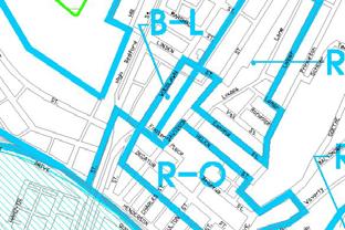
2 Williams Street Williams Avenue Oldtown Road Lower Virginia Avenue Upper Virginia Avenue Lower Frederick Street 2
 as permitted uses in similar zones: Frederick (52,767) Gaithersburg (52,613) Annapolis (35,838) Salisbury (23,743)")

Low Volume (warehouses, manufacturing, industrial uses, furniture stores, and")
 High Mediumhigh Medium Low Daily Traffic per 1,000 Gross Floor Area 14.")
3 Middle Frederick Street Greene Street Seton Drive Other Municipal Zoning Regulations Survey found that these municipalities have medical clinics (same as ambulatory care ) as permitted uses in similar zones: Frederick (52,767) Gaithersburg (52,613) Annapolis (35,838) Salisbury (23,743) Westminster (16,731) Easton (11,708) Environmental Suitability: Water Runoff The areas in question are already largely built-up no major water runoff issues No major population or business changes have occurred in these zones Seton Drive Zone: Adjacent to area identified by Comprehensive Plan as possible residential subdivisions Environmental Suitability: Traffic Medical clinics fall into the Medium-volume non-residential category of the Institute of Transportation Engineer s Trip Generation Manual (1)Low Volume (warehouses, manufacturing, industrial uses, furniture stores, and schools) (2) Medium (churches, medical offices, and community centers (3) Medium-high (car sales, specialty retail, government office) (4) High (super markets, restaurants, theaters, service stations, convenience markets) High Mediumhigh Medium Low Daily Traffic per 1,000 Gross Floor Area
")
4 Environmental Suitability: Traffic B-L zone already permits high traffic volume activities (categories 3 and 4) Ambulatory care is category 2 All of the B-L Zones are served by adequate arterial or collector roads Availability of Public Facilities Greene Street Canal Place improvements Lower Frederick Street Carver Community Center (once considered as location for ambulatory care facility) Williams Avenue WMHS Campus Lower Virginia Avenue Mason Complex improvements Municipal Service Center Improvements Present and Future Transportation Patterns Rolling Mill road improvements are in progress (Williams Street zone) Canal Parkway has eased traffic on lower Virginia Avenue Intersection of Greene Street (Greene Street zone) at Washington Street identified as problem intersection. Improvements are planned. Traffic intersection study indicated that signal not presently needed (Seton Drive) but City will continue to monitor the situation. Existing Land Uses in the Vicinity B-L zones on Greene Street, Williams Avenue, Middle Frederick Street, and Seton Drive either contain or are in close proximity to medical offices, clinics. Physicians offices are a permitted existing use Relationship to Comprehensive Plan Consistent with Comprehensive Plan and current proposed updates of plan. Objective 2.3 Encourage redevelopment of vacant and underutilized developed properties where compatible with adjacent land uses Action Amend the Zoning Ordinance to allow more flexibility in the redevelopment of vacant and underutilized developed properties provided that standards to minimize impacts on adjacent land uses are met. Relationship to Comprehensive Plan Objective 5.10 Maintain the City s position as the regional center of the health care industry. Support health care institutions within the City and work to accommodate future expansion needs, consistent with protecting adjacent neighborhoods. 4
5 Relationship to M&CC Policy Goals This zoning ordinance is part of series of zoning changes introduced by M&CC this year in order to: Encourage business growth Revitalize neighborhoods Improve city tax base 5
City Of Sparks Planning Commission Item
 Page 1 of 12 City Of Sparks Planning Commission Item Meeting Date: May17, 2012 Subject: PCN12009, Public Hearing, Consideration and possible action on a Master Plan Amendment and Rezoning request to change
2 January 13, 2010 Public Hearing APPLICANT: AUTOBELL CAR WASH, INC
 REQUEST: Conditional Use Permit (car wash) 2 January 13, 2010 Public Hearing APPLICANT: AUTOBELL CAR WASH, INC PROPERTY OWNER: MESSER 1060 INDEPENDENCE BOULEVARD STAFF PLANNER: Carolyn A.K. Smith ADDRESS
FOR LEASE. Spring Ridge Shopping Center PRESENTING. Call For Pricing Spring Ridge Parkway, Frederick, Maryland Location:
 FOR LEASE Call For Pricing Spring Ridge Parkway, Frederick, Maryland 21701 Spring Ridge Shopping Center Located at the entrance of Spring Ridge Community, the Spring Ridge Shopping Center serves the community
6. REGIONAL AND COMMUNITY FACILITIES DESIGNATIONS 6.1. OBJECTIVES FOR REGIONAL AND COMMUNITY FACILITIES LAND USE DESIGNATIONS
 6. REGIONAL AND COMMUNITY FACILITIES DESIGNATIONS INTRODUCTION The Regional and land use designations provide the primary locations for uses which satisfy the health, education and other service needs
BRYN MAWR. Tier 2 Characteristics: Location: Lancaster Avenue from Old Lancaster Road on the east to Norwood Avenue on the west
 BRYN MAWR Tier 2 Characteristics: Transit-oriented Mixed use Along Lancaster Avenue Serve township-wide needs Civic space Employment centers Location: Lancaster Avenue from Old Lancaster Road on the east
Planning & Zoning Commission Staff Report
 Planning & Zoning Commission Staff Report Meeting Date: May 26, 2015 Drafted by: Katherine Harrison-Rogers CASE # Z2886 PROJECT NAME: APPLICANT/ REPRESENTATIVE: Shawna Runyan PROPERTY OWNER: 1840 (previously
A P P E N D I X B - O P P O R T U N I T Y S I T E S
 A P P E N D I X B - O P P O R T U N I T Y S I T E S OPPORTUNITY SITES As listed in the Land Use Element, the City has identified 15 Opportunity Sites expected to be the focus of change and revitalization
DRAFT FOR COMMENT: EASTLAKE AVENUE PEDESTRIAN DISTRICT OVERLAY ORDINANCE
 DRAFT FOR COMMENT: EASTLAKE AVENUE PEDESTRIAN DISTRICT OVERLAY ORDINANCE Background: One of many actions in the 1998 Eastlake Neighborhood Plan was a proposal for an Eastlake Avenue Pedestrian District
Request Conditional Rezoning (R-15 Residential to Conditional B-2 Community Business) Staff Planner Kevin Kemp
 Staff Planner Kevin Kemp") Applicant Property Owner Three Five Ministries, Inc. Public Hearing May 11, 2016 City Council Election District Lynnhaven Agenda Item 4 Request Conditional Rezoning (R-15 Residential to Conditional B-2
Applicant Property Owner Three Five Ministries, Inc. Public Hearing May 11, 2016 City Council Election District Lynnhaven Agenda Item 4 Request Conditional Rezoning (R-15 Residential to Conditional B-2
WHEREAS, the current Comprehensive Plan was adopted in 2005; and
 RESOLUTION 2018-06 RESOLUTION TO AMEND THE CITY S COMPREHENSIVE PLAN TO (1) AMEND CHAPTER 4 TO ADD A SPECIAL REVITALIZATION DISTRICT FOR EDUCATION AND ECONOMIC DEVELOPMENT ; (2) DESIGNATE ON THE FUTURE
CHAPTER 21 NC-PUD NEIGHBORHOOD COMMERCIAL PUD DISTRICT
 CHAPTER 21 NC-PUD NEIGHBORHOOD COMMERCIAL PUD DISTRICT Section 21.1. Title and Purpose. The Neighborhood Commercial Planned Unit Development District, designated the, is intended for commercial uses of
4.1.3 LAND USE CATEGORIES
 4.1.3 LAND USE CATEGORIES a. City Center District The City Center District incorporates the existing character and mix of uses in downtown Belmont to encourage redevelopment and new development in keeping
IMPLEMENTATION STRATEGIES. In This Chapter. Goals & Strategies 182 Project List 183 Future Land Use 186 CHAPTER 11 IMPLEMENTATION STRATEGIES
 In This Chapter Goals & Strategies 182 Project List 183 Future Land Use 186 11 IMPLEMENTATION STRATEGIES NORTH AUGUSTA, SC 2017 COMPREHENSIVE PLAN 179 Individual commitment to a group effort that is what
Planning Districts INTRODUCTION
 INTRODUCTION To facilitate detailed examination of development prospects for all areas of the community, Delano has been divided into 14 planning districts. The location of these planning districts is
Chapter 7: Land Use Plan
 Chapter 7: Land Use Plan The intended purpose of the Land Use Plan is to guide the future physical development of Wall Township by designating proposed land use categories including proper location and
14 October 10, 2012 Public Hearing APPLICANT: MPB, INC
 14 October 10, 2012 Public Hearing APPLICANT: MPB, INC PROPERTY OWNER: MUNDEN & ASSOCIATES, LP STAFF PLANNER: Karen Prochilo REQUEST: Conditional Change of Zoning (AG-1 & AG-2 to Conditional O-2) ADDRESS
City of Chickasaw Land Use Comprehensive Plan 2030 Chapter5-Draft(2)Public review_
Public review_") Land Use Land Use refers to the activity or development characteristics of a given parcel of land. The Land Use Plan presented in the following pages, represents the City of Chickasaw s official position
Land Use Land Use refers to the activity or development characteristics of a given parcel of land. The Land Use Plan presented in the following pages, represents the City of Chickasaw s official position
Section 7 FUTURE LAND USE PLAN
 Section 7 FUTURE LAND USE PLAN City of Lancaster Comprehensive Plan D u n k i n, S e f k o & A s s o c i a t e s, I n c. FUTURE LAND USE PLAN INTRODUCTION Land can be viewed as a shared natural resource,
BRYN MAWR. Tier 2 Characteristics: Location: Lancaster Avenue from Old Lancaster Road on the east to Norwood Avenue on the west
 BRYN MAWR Tier 2 Characteristics: Transit-oriented Mixed use Along Lancaster Avenue Serve township-wide needs Civic space Employment centers Location: Lancaster Avenue from Old Lancaster Road on the east
CHAPTER 3 VISION, GOALS, & PLANNING PRINCIPLES. City of Greensburg Comprehensive Plan. Introduction. Vision Statement. Growth Management Goals.
 CHAPTER 3 VISION, GOALS, & PLANNING PRINCIPLES Introduction The Greensburg Comprehensive Plan is intended as a working community document. A combination of long and short-term goals, this document is intended
4. Shape Transitions. 4. Shape Transitions
 4. Shape Transitions 49 Zoning District Policies Overall Intent: Maintain neighborhood character by creating compatible transitions that minimize land use conflicts. Strategy: Define the character of zoning
SYRINGA VALLEY SPECIFIC PLAN NARRATIVE
 SYRINGA VALLEY SPECIFIC PLAN NARRATIVE Introduction With this application, Pleasant Valley South LLC ( Pleasant Valley ) seeks the City of Boise s approval of a new Specific Plan Ordinance to be added
12 November 10, 2010 Public Hearing APPLICANT: CHUNMA TAE KWON DO
 12 November 10, 2010 Public Hearing APPLICANT: CHUNMA TAE KWON DO PROPERTY OWNER: MOUNTAIN VENTURES VIRGINIA BEACH, LLC REQUEST: Conditional Use Permit (indoor recreational facility) STAFF PLANNER: Leslie
Staff Report and Recommendation
 Community Planning and Development Planning Services 201 W. Colfax Ave., Dept. 205 Denver, CO 80202 p: 720.865.2915 f: 720.865.3052 www.denvergov.org/cpd TO: City Council Neighborhoods and Planning Committee
and services The protection and conservation of environmentally significant and sensitive natural heritage features and functions.
 6. Land Use 6.0 Preamble A healthy and livable city is one in which people can enjoy a vibrant economy and a sustainable healthy environment in safe, caring and diverse neighbourhoods. In order to ensure
IH35 Corridor Plan Amendment to the Comprehensive Plan
 IH35 Corridor Plan Amendment to the Comprehensive Plan Background The corridor plan for the IH35 corridor is an amendment to the Burleson comprehensive plan. Generally, the purpose of a corridor plan is
5 TOWN OF MARKHAM OFFICIAL PLAN AMENDMENT NO. 144 MILLIKEN MAIN STREET SECONDARY PLAN
 5 TOWN OF MARKHAM OFFICIAL PLAN AMENDMENT NO. 144 MILLIKEN MAIN STREET SECONDARY PLAN The Planning and Economic Development Committee recommends the following: 1. The communication from Brendan O Callaghan,
5 May 9, 2012 Public Hearing APPLICANT: MICHAEL H. NORMENT
 5 May 9, 2012 Public Hearing APPLICANT: MICHAEL H. NORMENT PROPERTY OWNER: JOAN DALIS REQUEST: Conditional Use Permit (Commercial Parking Lot) STAFF PLANNER: Faith Christie ADDRESS / DESCRIPTION: 3233
Rezoning Petition Pre-Hearing Staff Analysis July 16, 2018
 Rezoning Petition 2018-044 Pre-Hearing Staff Analysis July 16, 2018 REQUEST Current Zoning: R-3 (single family residential) Proposed Zoning: UR-2(CD) (urban residential, conditional) LOCATION Approximately
ARLINGTON COUNTY, VIRGINIA
 ARLINGTON COUNTY, VIRGINIA County Board Agenda Item Meeting October 15, 2005 DATE: September 28, 2005 SUBJECT: Request to Advertise the adoption of the 2005 Clarendon Sector Plan C. M. RECOMMENDATION:
Existing Conditions Summary (Draft for Review)
") Existing Conditions Summary (Draft for Review) Prepared by March 16, 2015 Bird s-eye-view of Norwalk in 1899 (Cropped) Existing Conditions Summary (Draft for Review) March 16, 2015 Table of Contents 1.
Existing Conditions Summary (Draft for Review) Prepared by March 16, 2015 Bird s-eye-view of Norwalk in 1899 (Cropped) Existing Conditions Summary (Draft for Review) March 16, 2015 Table of Contents 1.
2.18 MU Mixed Use District.
 2.18. Intent - The is established to promote the development of an urban residential environment. The regulations are intended to encourage single family urban residential use and development while allowing
Economic Development & Housing Council Committee Comprehensive Plan Update September 20, 2005
 1 Economic Development & Housing Council Committee Comprehensive Plan Update September 20, 2005 Purpose To update the Committee on the ForwardDallas! Plan, including: Status Anticipated Products Public
7 June 13, 2012 Public Hearing
 7 June 13, 2012 Public Hearing REQUEST: Conditional Use Permit (Childcare) APPLICANT: BASILEIA EMPOWERING MINISTRIES PROPERTY OWNER: CONNEMARA ASSOCIATES, LLC STAFF PLANNER: Faith Christie ADDRESS / DESCRIPTION:
City of Coralville Planning & Zoning Meeting March 1, 2017
 City of Coralville Planning & Zoning Meeting March 1, 2017 Staff: Building & Zoning Official Jim Kessler, Assistant City Engineer Scott Larson and Administrative Assistant Dee Marshek 1. Call meeting to
3.5 C-I: Commercial - Industrial District
 3.5 Intent: The s are established to promote and maintain: gateway developments into the major industrial parks within the Town of Plainfield; and, the development of support facilities necessary for the
17.11 Establishment of Land Use Districts
 17.11 Establishment of Land Use Districts 17.11.010 Purpose. To promote the health, safety, and general welfare of City residents and those who come to South Salt Lake to work, exchange commerce and recreate.
Request Alternative Compliance (Commercial Parking Lot in Restricted Area) Staff Recommendation Approval. Staff Planner Ashby Moss
 Staff Recommendation Approval. Staff Planner Ashby Moss") Applicant Property Owners Pacific Avenue West, LLC Public Hearing April 11, 2018 City Council Election District Beach Agenda Item 2 Request Alternative Compliance (Commercial Parking Lot in Restricted
Applicant Property Owners Pacific Avenue West, LLC Public Hearing April 11, 2018 City Council Election District Beach Agenda Item 2 Request Alternative Compliance (Commercial Parking Lot in Restricted
Micco Park Village Development
 FOR SALE Call For Pricing Micco Park Village Development Proposed Project Property Details Micco Park Village Development PRICE Call For Pricing A monumental development opportunity of a lifetime! The
A Plan Enhancement Process for the Future of Howard Design Studio 2 May 28-30, The Howard Plan
 A Plan Enhancement Process for the Future of Howard Design Studio 2 May 28-30, 2011 The Howard Plan West of Pinecrest Future Land Use Plan Velp Corridor Land Use Analysis & Recommendations Duck Creek /Quarry
CONTENTS 8.0 LAND USE 8.1 GENERAL LAND USE 8.2 RESIDENTIAL 8.3 MIXED USE 8.4 COMMERCIAL 8.5 EMPLOYMENT LANDS
 8-2 Land Use 8.0 LAND USE CONTENTS 8.1 GENERAL LAND USE 8.1.1 Uses provided for in all Land Use Designations 8.1.2 Uses prohibited in Hazardous Lands, Hazardous Sites and Special Policy Areas 8.1.3 Uses
CHAPTER 4 COMMUNITY DEVELOPMENT AND DESIGN
 CHAPTER 4 COMMUNITY DEVELOPMENT AND DESIGN The Community Development and Design Chapter is extremely important because it, together with the Transportation and Circulation Chapter, provides the foundation
Rezoning Petition Post-Hearing Staff Analysis July 31, 2018
 Rezoning Petition 2018-044 Post-Hearing Staff Analysis July 31, 2018 REQUEST Current Zoning: R-3 (single family residential) Proposed Zoning: UR-2(CD) (urban residential, conditional) LOCATION Approximately
Request Modification of Conditions (Automobile Service Station) Staff Recommendation Approval. Staff Planner Jimmy McNamara
 Staff Recommendation Approval. Staff Planner Jimmy McNamara") Applicant Larae Tucker Property Owner Doswell Ventures, LLC Public Hearing May 10, 2017 City Council Election District Princess Anne Agenda Item 3 Request Modification of Conditions (Automobile Service
Applicant Larae Tucker Property Owner Doswell Ventures, LLC Public Hearing May 10, 2017 City Council Election District Princess Anne Agenda Item 3 Request Modification of Conditions (Automobile Service
To ensure that resources will be available to provide a consistent level of public services to the community.
 Future Land Use Plan The land use plan is one of the most prominent chapters in the Stillwater Comprehensive Plan. It provides a visual representation of what the community is expected to look like in
AWH REPORT OF THE PLANNING AND DEVELOPMENT DEPARTMENT FOR APPLICATION FOR REZONING ORDINANCE TO PLANNED UNIT DEVELOPMENT
 AWH REPORT OF THE PLANNING AND DEVELOPMENT DEPARTMENT FOR APPLICATION FOR REZONING ORDINANCE TO PLANNED UNIT DEVELOPMENT MAY 8, 2014 The Planning and Development Department hereby forwards to the Planning
City of Farmington. Downtown Plan. Amendment to the 1998 Master Plan Adopted October 11, 2004
 City of Farmington Amendment to the 1998 Master Plan Adopted October 11, 2004 Introduction Planning Background 1 Scope and Components of the Plan Amendment 2 Concept Introduction 3 Plan Concepts 3 Conceptual
Agenda Item. Applicant Logan Virginia Properties, LLC Property Owners Byler Azalea, LLC & Gateway Free Will Baptist Chuch
 Applicant Property Owners Byler Azalea, LLC & Gateway Free Will Baptist Chuch Public Hearing March 14, 2018 City Council Election District Kempsville Agenda Item 6 Request Conditional Rezoning (B-2 Community
2.11 GC - General Commercial
 2.11 GC - General Commercial Intent - GC: s are established to provide a location for higher volume and higher intensity commercial uses than the NR District. Activities in this District are often large
TEMPLE MEDICAL & EDUCATION DISTRICT
 City of Temple, Texas TEMPLE MEDICAL & EDUCATION DISTRICT 1 Description. The City of Temple joined in partnership with key public and private entities to jointly promote education and medical activities
Request Alternative Compliance to the prescribed criteria of the Oceanfront Resort District Form- Based Code. Staff Recommendation Approval
 Applicant Property Owner Steven H. Murden Public Hearing June 14, 2017 City Council Election District Beach Agenda Item 8 Request Alternative Compliance to the prescribed criteria of the Oceanfront Resort
REPORT OF THE PLANNING AND DEVELOPMENT DEPARTMENT FOR APPLICATION FOR REZONING ORDINANCE TO PLANNED UNIT DEVELOPMENT AUGUST 18, 2016
 REPORT OF THE PLANNING AND DEVELOPMENT DEPARTMENT FOR APPLICATION FOR REZONING ORDINANCE TO PLANNED UNIT DEVELOPMENT AUGUST 18, 2016 AWH The Planning and Development Department hereby forwards to the Planning
EXHIBIT A. Tax Increment Reinvestment Zone No. 1 (Town Center) First Amended Project Plan 1
 First Amended Project Plan 1") EXHIBIT A Tax Increment Reinvestment Zone No. 1 (Town Center) First Amended Project Plan 1 1 As amended by Resolution No. 2008-02-001(TR1R) of the Tax Increment Reinvestment Zone No.1, and approved to
EXHIBIT A Tax Increment Reinvestment Zone No. 1 (Town Center) First Amended Project Plan 1 1 As amended by Resolution No. 2008-02-001(TR1R) of the Tax Increment Reinvestment Zone No.1, and approved to
DEPARTURE FROM DESIGN STANDARDS DDS-586
 The Maryland-National Capital Park and Planning Commission Prince George s County Planning Department Development Review Division 301-952-3530 Note: Staff reports can be accessed at www.mncppc.org/pgco/planning/plan.htm.
DRAFT ETC Master Plan. Appendix D Land Uses and Demographics
 DRAFT ETC Master Plan Appendix D Land Uses and Demographics DRAFT ETC Master Plan Figure D 1. Existing Land Uses... D 3 Figure D 2. Future Land Uses... D 5 Figure D 3. Transportation Analysis Zones...
NORTH HARBOR INITIATIVE
 Indiana Harbor, East Chicago, Indiana NORTH HARBOR INITIATIVE Community Reinvestment Public Shoreline Connection Strong Leadership The City of East Chicago and are leading the revitalization of Indiana
REQUEST FOR PROPOSALS (RFP) DEVELOPMENT OF CITY-OWNED PROPERTY LOCATED AT THE NORTHWEST CORNER OF OLIVE BOULEVARD AND MIDLAND BOULVARD
 DEVELOPMENT OF CITY-OWNED PROPERTY LOCATED AT THE NORTHWEST CORNER OF OLIVE BOULEVARD AND MIDLAND BOULVARD") REQUEST FOR PROPOSALS (RFP) DEVELOPMENT OF CITY-OWNED PROPERTY LOCATED AT THE NORTHWEST CORNER OF OLIVE BOULEVARD AND MIDLAND BOULVARD CITY OF UNIVERSITY CITY 6801 DELMAR BOULEVARD UNIVERSITY CITY, MO
REQUEST FOR PROPOSALS (RFP) DEVELOPMENT OF CITY-OWNED PROPERTY LOCATED AT THE NORTHWEST CORNER OF OLIVE BOULEVARD AND MIDLAND BOULVARD CITY OF UNIVERSITY CITY 6801 DELMAR BOULEVARD UNIVERSITY CITY, MO
McDonald s Restaurant - Purcellville Town of Purcellville Special Use Permit Statement of Justification July 24, 2014
 Introduction / Written Statement McDonald s Restaurant - Purcellville McDonald s Corporation is proposing to redevelop the existing McDonald s eating establishment with a drive-through located at 121 N
NORTH HARBOR SPECIFIC PLAN
 NORTH HARBOR SPECIFIC PLAN City of Santa Ana Submitted By: Planning and Building Agency GPA 92-7/AA 10-61/SP2 The following is a chronology of the approved zoning ordinance amendments that have been incorporated
CHAPTER 12 IMPLEMENTATION
 CHAPTER 12 IMPLEMENTATION The 2010 Town of Denton Comprehensive Plan is intended to capture a vision of the future of Denton. As such, it provides a basis for a wide variety of public and private actions
Mill Conversion Overlay District Zoning Bylaw Amendment
 Mill Conversion Overlay District Zoning Bylaw Amendment To see if the Town will vote to amend the Zoning By-Law by adding a new Section 13, Mill Conversion Overlay District, and by amending Sections 2.1,
4 January 11, 2012 Public Hearing APPLICANT:
 . 4 January 11, 2012 Public Hearing APPLICANT: MID-ATLANTIC AUTO PROPERTY OWNER: DZR, LLC STAFF PLANNER: Leslie Bonilla REQUEST: Conditional Use Permit (truck rental, automobile service, and automotive/bulk
D1 September 11, 2013 Public Hearing APPLICANT:
 D1 September 11, 2013 Public Hearing APPLICANT: BEACH MUNICIPAL FEDERAL CREDIT UNION PROPERTY OWNER: SISTERS II, LLC STAFF PLANNER: Karen Prochilo REQUEST: Conditional Change of Zoning (AG-2 Agriculture
ULI St. Louis Technical Assistance Panel
 ULI St. Louis Technical Assistance Panel ULI St. Louis Technical Assistance Panel Sponsored by: Citizens for Modern Transit in partnership with METRO ULI St. Louis Mission Statement The mission of the
11 May 9, 2012 Public Hearing APPLICANT: KROGER LIMITED PARTNERSHIP I
 REQUEST: Conditional Use Permit (Automobile Service Station (Fuel Sales) ADDRESS / DESCRIPTION: 3901 Holland Drive 11 May 9, 2012 Public Hearing APPLICANT: KROGER LIMITED PARTNERSHIP I PROPERTY OWNER:
Comprehensive Development Guide
 INDUSTRIAL ELEMENT Comprehensive Development Guide 1 Industrial Element 7.1 Hardin County Industrial Overview BG PKWY Fort Knox Industrial Corridor Comprised of 11 parcels totaling 720 acres of land 68
Rezoning Petition Pre-Hearing Staff Analysis May 21, 2018
 Rezoning Petition 2018-018 Pre-Hearing Staff Analysis May 21, 2018 REQUEST Current Zoning: R-5 (single family residential), R-5 HD-O (single family residential, historic district overlay) and B-2(CD) HD-O
PLANNING COMMISSION WORKSESSION AGENDA. City Hall Second Floor Conference Room 9027 Center Street. July 1, :30 PM
 MEMBERS Harry J. Clark, Chairperson Bruce Wood, Vice-Chairperson Russell Harrison Ken Johnson Robert W. Schilpp Martha Wilson PLANNING COMMISSION WORKSESSION AGENDA City Hall Second Floor Conference Room
THAT the attached Terms of Reference for the Thornhill Centre Street Study be approved.
 COMMITTEE OF THE WHOLE AUGUST 18, 2003 THORNHILL CENTRE STREET STUDY PLANNING FILE: 15.92 Recommendation The Commissioner of Planning recommends: THAT the attached Terms of Reference for the Thornhill
Zoning and Development Considerations in the Boothbay Harbor Maritime/Water Dependent District
 Zoning and Development Considerations in the Boothbay Harbor Maritime/Water Dependent District Bob Faunce Lincoln County Planner Lincoln County Regional Planning Commission Board of Selectmen and Planning
CITY OF PUYALLUP. Background. Development Services
 CITY OF PUYALLUP Development Services 333 South Meridian Puyallup WA 98371 To: City Council From: Katie Baker, AICP, Planning Division Re: South Hill Neighborhood Plan Adoption Date: (Meeting date: February
12 January 12, 2011 Public Hearing APPLICANT: TAILWIND DEVELOPMENT GROUP,LLC PROPERTY OWNER: CITY OF VIRGINIA BEACH
 12 January 12, 2011 Public Hearing APPLICANT: TAILWIND DEVELOPMENT GROUP,LLC PROPERTY OWNER: CITY OF VIRGINIA BEACH STAFF PLANNER: Faith Christie REQUEST: Conditional Change of Zoning (from PD-H1 Planned
ARLINGTON COUNTY, VIRGINIA
 ARLINGTON COUNTY, VIRGINIA County Board Agenda Item Meeting of October 17, 2015 DATE: October 6, 2015 SUBJECT: SP #1 SITE PLAN AMENDMENT REVIEW to modify Zoning Ordinance sign requirements and facade modifications
LAND USE TANGLEWILDE/THOMPSON PLACE PLANNING AREA. C. Identified Neighborhood Groups and Homeowner s Associations
 LAND USE TANGLEWILDE/THOMPSON PLACE PLANNING AREA I. Profile of Tanglewilde/Thompson Place Planning Area (Revised 3/5/02) A. Location The Tanglewilde/Thompson Place Planning Area is located just east of
Land Use. Hardware Street Vendor Mixed-Use
 Land Use Definition Land Use is the way a piece of real estate is utilized. Existing, proposed, and adopted land uses all play a role in the planning process. Once a land use plan is adopted, the next
4.1 LAND USE AND PLANNING EXISTING CONDITIONS REGULATORY BACKGROUND LAND USES IN THE PLAN AREA SURROUNDING LAND USES
 4.1 LAND USE AND PLANNING This section includes a description of the existing land use plans that apply to the Plan area and a description of existing land uses in the vicinity. It also includes an analysis
CHARLES PUTMAN CHARLES PUTMAN AND ASSOCIATES, INC
 MEMORANDUM CHARLES PUTMAN & ASSOCIATES, INC. LAND DEVELOPMENT CONSULTANTS PLANNING ZONING PERMITTING 4722 NW Boca Raton Boulevard, Suite C-106 Boca Raton, Florida 33431 Phone: 561/994-6411 FAX: 561/994-0447
Lower Merion Commercial Districts Issues and Characteristics Handbook November 2013
 Lower Merion Commercial Districts Issues and Characteristics Handbook November 2013 DRAFT TOWNSHIP-WIDE VISION: To maintain and enhance commercial areas to complement the surrounding high-quality residential
MEMORANDUM AGENDA ITEM #IV.C
 MEMORANDUM AGENDA ITEM #IV.C DATE: NOVEMBER 27, 2017 TO: FROM: COUNCIL MEMBERS STAFF SUBJECT: LOCAL GOVERNMENT COMPREHENSIVE PLAN PROPOSED AND ADOPTED AMENDMENT CONSENT AGENDA Pursuant to Section 163.3184,
PLANNING COMMISSION REPORT
 PLANNING COMMISSION REPORT REZONING CASE NO. RZ-14-002 REPORT DATE: February 10, 2015 CASE NAME: 9990 W. Alameda Ave. Rezoning PLANNING COMMISSION DATE: February 18, 2015 ADDRESS OF REZONING PROPOSAL:
LAND USE CATEGORIES. City of Sparks Comprehensive Plan Chapter Two: Pathway to the Future - Draft 1
 LAND USE CATEGORIES The following tables summarize the land use categories identified on the Map, describing the s designation shown on the Map. The tables summarize the primary uses and other uses, residential
APPLICATION NUMBER A REQUEST FOR
 APPLICATION NUMBER 5488 A REQUEST FOR FRONT SETBACK, FRONTAGE LANDSCAPING, VEHICLE STACKING AND PROTECTION BUFFER VARIANCES TO ALLOW THE CONSTRUCTION OF A PHARMACY WITHIN 12.4 OF A FRONT PROPERTY LINE,
LAND USE CATEGORIES. City of Sparks Comprehensive Plan Land Use Categories - Draft
 LAND USE CATEGORIES The following tables summarize the land use categories identified on the Map, describing the s designation shown on the Map. The tables summarize the primary uses and other uses, residential
Request Conditional Use Permit (Car Wash Facility) Staff Recommendation Approval. Staff Planner Jonathan Sanders
 Staff Recommendation Approval. Staff Planner Jonathan Sanders") Applicant Property Owner SunTrust Bank Public Hearing October 10, 2018 City Council Election District Princess Anne Agenda Item 2 Request Conditional Use Permit (Car Wash Facility) Staff Recommendation
Applicant Property Owner SunTrust Bank Public Hearing October 10, 2018 City Council Election District Princess Anne Agenda Item 2 Request Conditional Use Permit (Car Wash Facility) Staff Recommendation
Commercial Development Proposal Tenth Line Road. Planning Rationale Report. Minto Developments Inc.
 Commercial Development Proposal 2168 Tenth Line Road Report September 2015 Prepared for Minto Developments Inc. Paquette Planning Associates Ltd. 56 Hutchison Avenue Ottawa, Ontario K1Y 4A3 PH: 613-722-7217
Issues, Challenges & Opportunities
 Below is a summary of issues, challenges, and opportunities relating to the revitalization of Downtown Romeoville and potential development of the Village s East Side TOD Area. Current Issues & Challenges
4 September 14, 2011 Public Hearing APPLICANT:
 4 September 14, 2011 Public Hearing APPLICANT: MID-ATLANTIC AUTO PROPERTY OWNER: KHJ, LLC STAFF PLANNER: Leslie Bonilla REQUEST: Conditional Use Permit (motor vehicle rental, automotive service, and automotive/bulk
310 East Main Street, Suite 4 Bartow, FL Phone:
 3409 W. Lemon Street Tampa, FL 33609-1433 Phone: 813-250-3535 310 East Main Street, Suite 4 Bartow, FL 33830-4715 Phone: 863-784-3155 Hamilton Engineering &, Inc. Client s choice for professionalism integrity
CHAPTER 10 GC GENERAL COMMERCIAL DISTRICT
 CHAPTER 10 GC GENERAL COMMERCIAL DISTRICT SECTION 10.01 DESCRIPTION AND PURPOSE A. This District is intended for commercial development of a general nature near areas where greater concentrations of residential
Northeast Gateway Revitalization Plan
 Prepared by: Carrie Kruse, Office of Economic Development, 400 Robert D. Ray Drive, Des Moines, IA 50309 Phone: 515/283-4012 Return Address: City Clerk City Hall, 400 Robert D. Ray Drive, Des Moines, IA
Planning Division Case Report
 Planning Division Case Report SE17-0006 Review Date: June 2, 2017 Property Owner: Applicant: SB-Vets-1, LLC SB-Vets-1, LLC Owner Address: 900 SW Pine Island Road, Suite 202 Cape Coral, FL 33991 Authorized
Official Zoning Map Amendment Application #2018I-00047
 Community Planning and Development Planning Services 201 W. Colfax Ave., Dept. 205 Denver, CO 80202 p: 720.865.2915 f: 720.865.3052 www.denvergov.org/cpd TO: Denver Planning Board FROM: Chandler Van Schaack,
SUSSEX COUNTY COMPREHENSIVE PLAN COUNTY PLANNING AND ZONING COMMISSION WORKSHOP
 SUSSEX COUNTY COMPREHENSIVE PLAN COUNTY PLANNING AND ZONING COMMISSION WORKSHOP August 21, 2017 TODAY S WORKSHOP Public Comment Utilities Update Economic Development Update Future Land Use Discussion Public
The GATEWAYS Sub Area Master Plan. City of Walker
 The GATEWAYS Sub Area Master Plan City of Walker Introduction: The Walker City Commission and Planning Commission decided in 2011 to create a sub-area master plan for the Remembrance Road and Wilson Avenue
VILLAGE OF CLEMMONS PLANNING BOARD DRAFT STAFF REPORT
 VILLAGE OF CLEMMONS PLANNING BOARD DRAFT STAFF REPORT PETITION INFORMATION Docket # C-226 Staff Megan Ledbetter Petitioner(s) JBJH Properties, LLC Owner(s) JBJH Properties, LLC Subject Property 5892-49-1766
Chapter 1: Introduction
 Chapter 1: Introduction The Penn Avenue Community Works Corridor Vision and Implementation Framework presents an integrated communitybased vision and a coordinated, long-term implementation framework for
4121 Lawrence Avenue East Rezoning Application Preliminary Report
 STAFF REPORT ACTION REQUIRED 4121 Lawrence Avenue East Rezoning Application Preliminary Report Date: October 11, 2011 To: From: Wards: Reference Number: Scarborough Community Council Director, Community
TABLE OF CONTENTS 1.0 INTRODUCTION... 3
 TABLE OF CONTENTS 1.0 INTRODUCTION... 3 1.1. BACKGROUND... 3 1.2. THE PROPOSAL... 5 2.0 EXISTING POLICY FRAMEWORK... 5 2.1. PROVINCIAL POLICY STATEMENT (PPS)... 5 2.2. CITY OF LONDON OFFICIAL PLAN (OP)...
Arlington County Retail Plan
 Arlington County Retail Plan Draft April 28, 2015 EXECUTIVE SUMMARY Arlington will be a community where retail is convenient, appealing, activating and sustainable; that provides interest and authenticity,
AMENDED AND RESTATED DEVELOPMENT PLAN FOR THE SPORTS FACILITY PROJECT WITHIN PLANNED DEVELOPMENT AREA NO. 87 BOSTON LANDING
 AMENDED AND RESTATED DEVELOPMENT PLAN FOR THE SPORTS FACILITY PROJECT WITHIN PLANNED DEVELOPMENT AREA NO. 87 BOSTON LANDING GUEST STREET, LIFE STREET AND ARTHUR STREET BRIGHTON AREA OF BOSTON DATED: August