PCAL Case Study Open Spaces: Blayney Heritage Park
|
|
|
- David Quinn
- 5 years ago
- Views:
Transcription


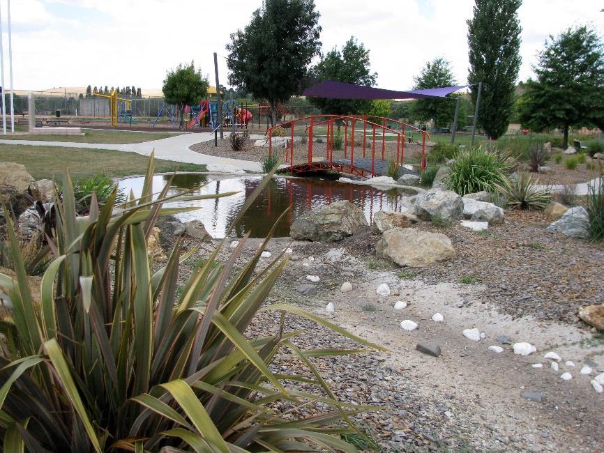
1 PCAL Case Study Open Spaces: Blayney Heritage Park Introduction Blayney Heritage Park is an area of high quality open space that offers a range of active and passive recreation facilities. The multi-purpose park is notable for the range of facilities it provides, catering for a wide range of users, from children to adults, families and groups, walkers and cyclists. The adventure playground is a particularly good example of a carefully designed children s play area. Its range of innovative and out of the ordinary facilities attract high numbers of children and encourage their physical activity. As well as children s play facilities, the park has a cycle/walking path around the perimeter, shaded seating and barbecue shelters, and an amphitheatre for larger gatherings. Overlooking the adjacent wetland, the park is also an attractive place for people to interact with nature, and includes shallow ponds and a constructed creek with high quality landscaping. The clustering of different facilities in the park, and the location adjacent to the local tennis club and within easy walking distance from the town centre, shops and local schools has created a vibrant and well-used area of open space. The location of the park adjacent to the Mid Western Highway also means that it is a convenient stopping point for motorists travelling between Bathurst and Cowra. The park is regularly used for community events such as Australia Day and RTA Bike Week.
2 2 Description/Context Blayney is the main town in the Shire of the same name and is located on the Mid-Western Highway in Central Tablelands of New South Wales, approximately 235km west of Sydney. The town is a 25 minute drive from Bathurst and has a population of 3,000. Heritage Park is located just off the town s main street (Adelaide Street), within easy walking distance from local residences, shops, services and schools. Completed in 2008, Heritage Park provides a diversity of passive and active recreation facilities clustered and linked together in an attractive setting. The park caters effectively to both children and adults, and includes a range of well-designed places for people to meet, sit and talk. The Park is particularly notable for its range children s play equipment that goes far beyond the typical (and often under-used) items. The adventure playground provides children of all ages and abilities with opportunities for fun and stimulating physical activity. The constructed creek and ponds, with rocks and footbridges provide opportunities for nature-based play. The park also features a walking/cycling path that weaves around the perimeter ideal for younger children and those learning to ride. The park also caters to adult users, with a range of other facilities including a giant chess board, a fenced off-leash dog walking area, barbecues, seating and picnic facilities. A shaded amphitheatre provides a stage for community gatherings, and accessible toilets are also provided. As well as being highly functional, the park is an attractive and pleasant place to spend time, with many shade trees, a sensory garden and creek providing a relaxing setting and a connection to nature. The location of the park on the edge of town also provides attractive views across the wetlands to the hills and farmland beyond. Design Process In the 1980s this parcel of vacant land was a popular venue for BMX riding and competitions. From around 1990 this activity ceased and the site became disused, becoming dominated by weeds and long grass and subject to considerable illegal dumping of fill, rubbish and car tyres. In 1993, the site was cleared and a modest park, consisting of a small playground and two barbeques was constructed. In the late 1990s, Council identified the need for a complete redevelopment of the Heritage Park site, to address a lack of formal play space within the town and provide a rest area for travellers. Community groups were involved in developing a concept plan, which discussed the emotional, sensory, organic, neurological, intellectual and physical needs of children, and identified characteristics that the park should include. The plan identified a need for a suitable facility for children, their families and carers to play and interact with nature. The concept plan also noted a need to provide opportunities for all children to play together regardless of ability. While Council s limited budget prevented all the proposed features being built at that time, in 1998, extensions to the playground equipment were added and a hedge maze planted. Council also developed a wetland area adjacent to the site, with funding from the NSW Stormwater Trust. The wetland enables people to observe native flora and fauna in close proximity to the town. In 2006, Council revisited the plan for a complete redevelopment of the park, and sought support from local businesses and community organisations. Funding of $500,000 was provided through a combination of Council s government grants, Section 94 development contributions and donations from local private companies. The new park was officially opened in May Evaluation The park is a good example of a project that fulfils the PCAL design objectives for open space namely providing public open spaces within walking distance from dwellings, and clearly defining walking and cycling routes that pass through open spaces and connect to the broader walking and cycling network. The park encourages and enables active living by incorporating a number of the design considerations set out in the open spaces section of Designing Places for Active Living, namely: Provide open space within safe, comfortable walking distance from dwellings
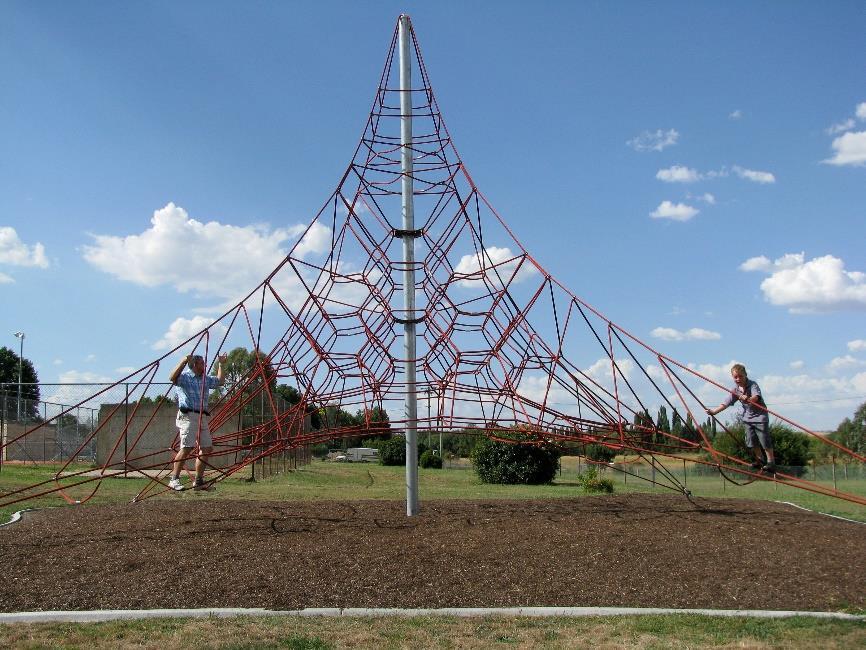
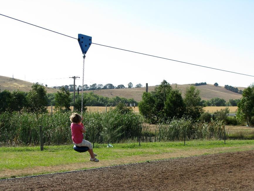
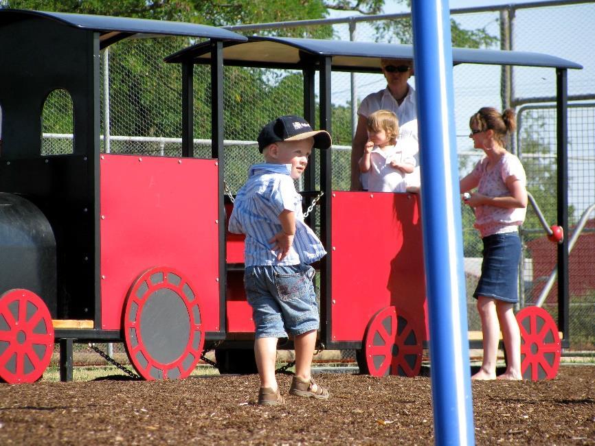
3 3 Heritage Park is located just off the town s main street (Adelaide Street), within easy walking distance from local residences, shops, services and schools. Blayney is a small and relatively compact town, meaning that the majority of dwellings would be within a one kilometre walk of the park. Many are much closer for example, houses on Adelaide and Martha Streets are immediately adjacent to the park, and residents to the south of the park can access it via the short President s Walk from Mitchell Street. The park is an 800 metre walk from the local high school and a one kilometre walk from Blayney Public School. Connect public open space to the local and regional walking and cycling network with safe pedestrian crossings leading to or near park entrances The park is well integrated with the local town, with footpaths leading directly to, and around the Park from Adelaide Street. These paths also connect to the President s Walk, on the other side of Martha Street. A path also runs through the park, with footbridges over the creek and ponds, and provides a pleasant route for walkers and a safe circuit for children learning to cycle. The track features signage to encourage safe use and help children to understand common road rules, and has been used for RTA Bike Week events to educate children on bicycle safety. Encourage active recreation through the provision of a range of well designed play and sporting facilities The park s adventure playground contains a range of innovative and well-designed play equipment that offers children many opportunities for fun and stimulating play. Features including a space net (large rope climbing pyramid), flying fox (cable ride), comet (spinning ride) and a mouse house (a timber-lined cylinder, large enough to walk through, which rotates when children walk or run inside it). For younger children the park includes the more familiar slides, swings climbing frames, a toy train, and a large shaded sandpit. This variety of equipment encourages active recreation by providing for a range of activities for children of all ages. The location of the different activities in different parts of the park also encourages children to run around and explore the different areas. The park also provides a range of nature-based play opportunities. A constructed central creek with ponds and a sensory garden provide an interesting and diverse nature corridor. These features offer children (and adults) a range of active and exploratory experiences, with opportunities to jump across rocks, play with water, and observe native fauna. The creek and ponds feed into the adjoining wetlands and the planting of native endemic species supports water filtration and attracts birds and other wildlife. Create and maintain attractive and pleasant places for people to walk, cycle, train, sit, meet and talk The park is an attractive and pleasant place for people to gather, and is used in many ways by the local community. Visitors can play chess on the giant chess board, sit and relax on one of the many conveniently placed and shaded seats, or meet to enjoy a barbeque or picnic. A carefully designed layout means children can play within sight of parents and carers. The natural setting, attractive landscaping, and the gathering areas near the creek, ponds and gardens make the park an inviting place for people to meet, sit and talk. Disabled access toilets are also provided. The park also provides a venue for large community gatherings, with the shaded amphitheatre providing an effective area to stage local events. Blayney schools have used the wetlands and sensory garden as a safe and accessible venue for environmental education, and Council officers have also provided onsite environmental education to various groups including school and university students and Scouts. As well as providing a high quality recreational facility for local residents, Heritage Park provides a rest stop for travellers on the Mid Western Highway and has also been identified by Council as a potential site for the RTA sponsored Driver Reviver Program, during holiday periods. Blayney Shire Council and the local energy authority are considering developing a summer cinema series, with a wall on which to project movies during summer evenings. Promote safety and amenity through good design, such as drought-resistant shade trees, natural surveillance from surrounding uses, seating, lighting and clear and convenient entry points
4 4 The Park features numerous drought-resistant shade trees, many of which have seating beneath them. Large shade sails are provided over the sand pit and amphitheatre areas. A range of seating helps provide a high level of amenity in the park. This includes bench seating to view the adjacent tennis courts, seating grouped under shade trees and overlooking the children s play areas, and picnic seating within the barbecue shelters. The park is well lit with dedicated light poles installed, as well as light spilling from adjacent streetlights. The park has clear and convenient entry points, and surrounding uses provide good surveillance for the park there are houses along Adelaide Street that directly overlook the western side of the park, and the Blayney District Tennis Club is immediately adjacent, overlooking the park from the north. Cluster compatible land uses within or at the edge of parks or open space corridors, such as cafes and restaurants, child care centres and indoor/leisure/sports centres. This helps reduce the land required for parking and improves accessibility. In addition to the many facilities provided within the park, there is a tennis club next door, with which the park shares parking spaces. Recently a mobile café has set up at the Park on some afternoons improving accessibility by attracting more people to the park and encouraging parents to stop for longer, perhaps sitting down for a coffee while their children play in the park. Project Participants Blayney Shire Council NSW Department of Sport and Recreation Newcrest Mining Nestle Purina Country Energy Project Summary Location: Blayney is in the NSW Central Tablelands on the Mid Western Highway between Bathurst and Cowra. The town is 35 kilometres SE from Orange and 37km SW from Bathurst. Completion date: May 2008 Planning authority: Blayney Shire Council Funding bodies: Blayney Shire Council, NSW Department of Sport and Recreation, Newcrest Mining ($50,000 donation), Nestle Purina ($50,000 donation), Country Energy. Cost: $500,000


5 5 Images 1. Walking distance from dwellings 2. View over wetlands 3. Houses adjacent


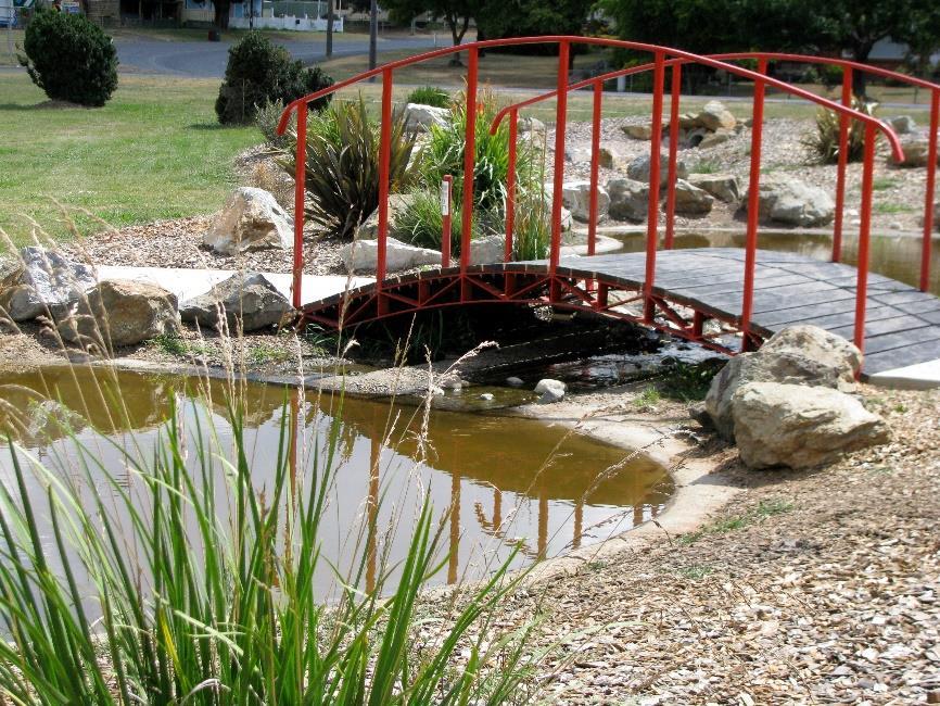
6 6 4. President s Walk 5. Walking track 6. Footbridge

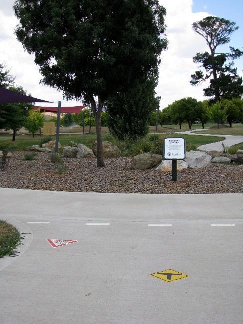
7 7 7.Safe signage 8. Stimulating and challenging play 9. Flying fox


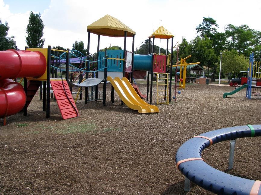
8 8 10. Play equipment 11. Play equipment 12. Play equipment


9 9 13. Play equipment 14. Play equipment 15. Play equipment


10 Sandpit 17. Creek 18. Pond 19. Nature play


11 Chess 21. Amenities seats near play area 21. Amenities BBQ


12 Amenities - Toilets 23. Adjacent to tennis courts 24. Car park café
Seven Creeks Neighbourhood. Community Plan
 Seven Creeks Neighbourhood Community Plan INTRODUCTION SEVEN CREEKS The Seven Creeks Estate is home to a steadily expanding community of families, couples and individuals who enjoy the very best of both
GISBORNE PLAYGROUND UPGRADE STRATEGY
 GISBORNE PLAYGROUND UPGRADE STRATEGY OPUS LANDSCAPE ARCHITECTURE 06 MARCH 2014 CONTENTS CONTENTS 1. Introduction and Location Plan 2. Playspace Design Principles 3. Playspace Design Considerations 4. Condition
SURVEY BACKGROUND. In addition to the upgrade of the play space, the courts and oval lighting will be upgraded.
 SURVEY BACKGROUND The Edwardstown Soldiers Memorial Recreation Ground play space has been identified in Council s Play Space Strategy for upgrade in the 2014/15 financial year. In addition to the upgrade
Section 4 - Public Realm & Landscape proposals Landscape Masterplan. Section 4 52
 - Public Realm & Landscape proposals Landscape Masterplan 52 Proposed Masterplan - Green Infrastructure Strategy District Park 4.33 Ha to provide Passive and active recreation with a large play area which
New Park / Entry Court & Plaza Concept Design
 New Park / Entry Court & Plaza Concept Design The SECC Public realm is proposed to have a focus on health, wellness, and community and that site users will include patrons of the neighbourhood. The block
Wentworth Point July Community Information Session Feedback Summary
 Wentworth Point July Community Information Session Feedback Summary Introduction On Saturday, 28 July 2018, Landcom held a community information session from 11am to 1pm, at the Pulse Club, Wentworth Point,
Waterlily Playscape Committee Waterlily Playscape, Waterlily Park, Ocean Shores Draft Concept Plan. G Issue D 14/07/16
 Waterlily Playscape Committee Waterlily Playscape, Waterlily Park, Ocean Shores Draft Concept Plan Issue D 14/07/16 New two level wharf for fishing and interacting with waters edge (exact location to be
South th E ast Communit ity Centre (SECC)
") South East Community Centre (SECC) 1 New Park Design & Community Centre Update Thursday, February 8, 2018 Public Open House Thank you for attending this Open House! The town and the Consulting Team will
South East Community Centre (SECC) 1 New Park Design & Community Centre Update Thursday, February 8, 2018 Public Open House Thank you for attending this Open House! The town and the Consulting Team will
Appendix H: Easement cross sections
 Appendix H: Easement cross sections SHARED PATH 1.5m FOOTPATH NATURE STRIP 7.3m CARRIAGEWAY 2.7m NATURE STRIP EXISTING PIPELINE 150mm DIA 5.0m (approx.) LOCAL ACCESS ROAD EXISTING PIPELINE 500mm DIA 2.7m
Port Macquarie Town Centre Landscape Architects
 Port Macquarie Town Centre Town Green Master Plan Review Tract Landscape Architects Urban Designers Town Planners A review of the Town Green Master Plan Port Macquarie, New South Wales Prepared by Tract
Reimagining Arnolds Creek. Community engagement report. May 2018
 Reimagining Arnolds Creek Community engagement report May 2018 Melbourne Water is owned by the Victorian Government. We manage Melbourne s water supply catchments, remove and treat most of Melbourne s
Welcome to the Neighborhood! COPPERLEAF NEIGHBORHOOD GUIDE
 Welcome to the Neighborhood! COPPERLEAF NEIGHBORHOOD GUIDE 2017 At Copperleaf, feeling at home just comes naturally. Not surprising when you take a look around at the abundance of resources we offer to
Small Towns Consultation Gordon Community Conversation 26 February 2015 Meeting Notes Total Community Attendees - 44
 Small Towns Consultation Gordon Community Conversation 26 February 2015 Meeting Notes Total Community Attendees - 44 The following is the information we received at the Community Conversation. Community
Dowdy Park. Concept Plans TOWN OF NAGS HEAD NORTH CAROLINA. Developed by: Albemarle & Associates, Ltd VHB/ Vanasse Hangen Brustlin, Inc.
 TOWN OF NAGS HEAD NORTH CAROLINA Concept Plans Developed by: Albemarle & Associates, Ltd VHB/ Vanasse Hangen Brustlin, Inc. Site Looking Southeast Dowdy Park Existing Conditions Nags Head Woods Sound Future
GREENVALE CENTRAL PRECINCT STRUCTURE PLAN
 76 Conservation area boundary. Low Fence to exclude vehicles but allow pedestrian access Front boundary of allotment 5.0m MINIMUM SETBACK Path providing public access to dwellings fronting Conservation
More than 30 adults and 19 children were involved in these community workshops.
 Linwood Workshops held at Household of Faith Deliverance Church 3.29.08 and 4.05.08 What is a Design Workshop? We use the term workshop (often called charrette among design professionals) to describe a
North Adelaide Playspace and Pocket Orchard
 The Adelaide City Council invites engagement from the community about Playspace and Pocket Orchard Project Summary Adelaide City Council invites feedback from the community on the Tidlangga (Park 9) Playspace
CHAPPLES PARK MASTER PLAN
 CHAPPLES PARK MASTER PLAN Presentation of Preliminary Development Options Public Open House #2 Wednesday November 2 nd, 2016 TONIGHT S AGENDA 1. Welcome & Introductions 2. Presentation by Sierra Planning
10 Proposed Redevelopment, Tewkesbury Road, Cheltenham SCHEME EVOLUTION STARBUCKS
 SCHEME EVOLUTION STARBUCKS The proposed Starbucks Drive Thru alongside the proposed food store provides an appropriate mix of uses, suitable for this location. The proposed store is bespoke, designed specifically
SUNSET COVE WALKING TRACK PROJECT
 SUNSET COVE WALKING TRACK PROJECT MANAGEMENT PLAN 2013 2015 Prepared by: Paynesville Landcare/Coastcare Group Prepared for: East Gippsland Shire Council (Committee of Management of Crown Land) East Gippsland
Brains and Archibald park concept plan
 Brains and Archibald park concept plan The Brains and Archibald park concept plan has been commissioned by the Whau Local Board for the purpose of providing a vision to guide improvements to Brains Park
Pukerua Bay School Landscape Masterplan
 BRIEFING NOTES Overriding Principles: Recognise and protect the school s landscape assets. Create unity and cohesion throughout the school. Recognise and develop the school s unique identity. Reduce maintenance.
RECREATION AND OPEN SPACE VISION
 City of South Lake Tahoe General Plan Policy Document Recreation and Open Space Element INTRODUCTION This element provides the policy context for the City of South Lake Tahoe to achieve its vision for
boyd park draft concept plan CITY ROAD BALSTON STREET KINGS WAY KAVANAGH STREET CITY OF MELBOURNE BOYD COMMUNITY HUB MULTIPURPOSE COURT NORTH LAWN
 draft concept plan CITY ROAD NORTH LAWN MULTIPURPOSE COURT BOYD COMMUNITY HUB SCHOOLYARD KINGS WAY FOREST GARDEN BALSTON STREET VILLAGE GREEN FUTURE DEVELOPMENT PICNIC & PLAY TERRACE PARK EXPANSION KAVANAGH
The following principles guide the development of goals and strategies to protect and promote these amenities:
 OPEN SPACE/PARKS/TRAILS/RECREATION GOALS/STRATEGIES Cherry Hills Village is a living environment that offers low density development, open areas, public scenic vistas, public trails and public parks. This
PUBLIC MEETING APRIL 21, 2016
 HARWOOD PARK PUBLIC MEETING APRIL 21, 2016 HARWOOD PARK CONTEXT - 2 aerial image of site HARWOOD PARK PUBLIC MEETING On April 21, 2016, Parks for Downtown Dallas, the City of Dallas Park and Recreation
Community Meeting #2. Cabrillo Playground Renovation A 2008 Clean and Safe Neighborhood Parks Bond Project
 Cabrillo Playground Renovation A 2008 Clean and Safe Neighborhood Parks Bond Project Community Meeting #2 September 22, 2010 District Supervisor Eric Mar Paulina Araica, Project Manager Andy Maloney, Architect
Community Design Guidelines. Port Wallace DRAFT
 Community Design Guidelines Port Wallace DRAFT Energy 1 2 3 Nature Movement Connections Built Form DRAFT Layout Energy 1 Nature Community Design Guidelines GREAT COMMUNITIES PROTECT, CELEBRATE, AND CONSERVE
East Bayshore Road Neighbourhood
 East Bayshore Road Neighbourhood Northridge Property Management Urban Design Brief 3195 East Bayshore Road City of Owen Sound January 2016 East Bayshore Road Neighbourhood Northridge Property Management
Development Type - Open Space
 Development Type - Open Space Open Space Introduction The provision of open space within a neighbourhood presents opportunities for individuals to interact with other people, increase their levels of physical
Throughout. square. (Crystal City Vision Plan 2050)
") 1: Terms related to the PSMP document 1 public space (see also public realm, civic space) An open space designated on the regulating plan, accessible to all, including Plazas, Mini Parks, and Neighborhoods
1: Terms related to the PSMP document 1 public space (see also public realm, civic space) An open space designated on the regulating plan, accessible to all, including Plazas, Mini Parks, and Neighborhoods
Enhancing Attawandaron Park
 Enhancing Attawandaron Park # M001 This project idea proposes to involve and empower members of the Attawandaron neighbourhood to get involved in discussions with City staff about ways to enhance the Attawandaron
2.5.2 Design Study - Outdoor 0.0 Play Heading Spaces
 2.5.2 Design Study - Outdoor 0.0 Play Heading Spaces The study highlights how the Accessibility Standard for the Design of Public Spaces (the Standard) applies to the design of an outdoor play space. Project:
Executive Summary Public Space / Community Space
 Executive Summary This discussion paper suggest how the concept of Public Space/Community Space, set out by the Callan Park Taskforce, can be first understood and then applied to Callan Park. This paper
M E M O R A N D U M February 21, 2018
 M E M O R A N D U M February 21, 2018 Project: Action Requested: Background Information: CP18-001, Ordinance No. 1060-A, Amendment to the City of Southlake Parks, Recreation & Open Space / Community Facilities
Long Crendon Neighbourhood Plan Local Green Space and Landscape Study Report September 2016
 Long Crendon Neighbourhood Plan Local Green Space and Landscape Study Report September 2016 1 Long Crendon Neighbourhood Plan Local Green Space and Landscape Study Report This report has been prepared
TONIGHT S MEETING DRAFT SUMMARY REPORT CAPE WOOLAMAI COASTAL RESERVES MASTER PLAN PHILLIP ISLAND SOUTH AND NORTH COAST KEY AREA PLAN OCTOBER 2014
 TONIGHT S MEETING Phillip Island Nature Parks and Bass Coast Shire Council have partnered to achieve a comprehensive and integrated master plan for the safe use and management of Cape Woolamai Coastal
UNIVERSITY TOWN NEIGHBOURHOODS 5.2 ECO-CORRIDOR MELBOURNE CAMPUS MASTER PLAN 2014
 5.2 ECO-CORRIDOR 37 ECO-CORRIDOR EXISTING CONDITIONS & VISION NEIGHBOURHOOD VISION Investment in the Eco-corridor Neighbourhood will signify the University s commitment to supporting local ecology and
ANCHORAGE PARK REPORT CARD Assessing A Park s Appearance, Function, & Condition
 ANCHORAGE PARK REPORT CARD Assessing A Park s Appearance, Function, & Condition Park Name: Is Your Park an A or an F? Your Name: Contact Information Optional: Date: General Instructions: Phone: Email:
Draft Ada Street Cardiff Area Plan
 Draft Ada Street Cardiff Area Plan (Draft Amendment to Lake Macquarie Development Control Plan 2014) Exhibition: The draft Area Plan is on public exhibition from 29 February 2016 to 29 March 2016. Submissions:
North Oakville East Parks Facilities Distribution Plan. November, 2009
 North Oakville East November, 2009 POLICY CONTEXT 1) Purpose a) The purpose of this document is to be a guide for the location, configuration, design and development of the parks system for the North Oakville
WILLASTON PLAYSPACE // OPTION 1.1 LEGEND P r o je ct No. 18WOP / SCALE / Date of Issue
 WILLASTON PLAYSPACE // OPTION. P r o je ct No. WOP / :00@A / Date of Issue.0. Significant distance from other recreation facilities Visually disconnected from other facilities in precinct Access to services
Wentworth Point Peninsula Park
 WELCOME Welcome to today s community information session. Landcom has been appointed by Roads and Maritime Services (owners of the land) to construct Point Park. Today s information session is to give
NEIGHBOURHOOD DECISION MAKING SOUTHEAST LONDON
 NEIGHBOURHOOD DECISION MAKING SOUTHEAST LONDON Thank you for voting! Please use the paper provided to mark down the numbers of the idea you would like to vote for, and bring it to the voting station. VOTE
INDOOR SPORTS COMPLEX PROJECT BRIEF
 a PROJECT BRIEF 1.0 INTRODUCTION This Project consists of designing and built of an Indoor sports complex which will become the first building developed in Hulhumale solely for indoor sports and recreational
LISMORE PARK, KELLY S FLAT, ALLENBY PARK, FAULKS TERRACE, DOMINI PARK & KENNEDY CRESCENT
 Attachment A: PROPOSED RESERVE MANAGEMENT PLAN FOR THE RECREATION RESERVES KNOWN AS: LISMORE PARK, KELLY S FLAT, ALLENBY PARK, FAULKS TERRACE, DOMINI PARK & KENNEDY CRESCENT WANAKA RECREATION RESERVES
Wilbur Young Park. Park Land Established: Developed Acres: 15 acres Undeveloped Acres: 25 acres
 Wilbur Young Park Park Location: 1100 SE Adams Dairy Parkway Park Land Established: 1987 Park Size: 40 acres Developed Acres: 15 acres Undeveloped Acres: 25 acres Park Type: Community Park Amenities: Shelter
IMPLEMENTATION GUIDELINE NO. 27
 IMPLEMENTATION GUIDELINE NO. 27 Guidance on Recreation Range and Opportunity Outcomes Arising from Embellishment of Public Parks Date of Council Resolution This guideline was originally adopted by Council
ROSENTHAL CARPARK LIFE BETWEEN BUILDINGS IN LANE COVE
 south square Life between buildings includes all the very different activities people engage in when they use common city space; purposeful walks from place to place, promenades, short stops, longer stays,
Monte Cecilia Park DRAFT CONCEPT PLAN FEBRUARY 2015 AUCKLAND COUNCIL
 Monte Cecilia Park DRAFT CONCEPT PLAN FEBRUARY 2015 AUCKLAND COUNCIL 1 Site analysis and concept 1.1 Location Site Extent MT ALBERT RD HILLSBOROUGH RD BUDOCK RD MONTE CECILIA PARK KORMA RD HERD RD Figure
SITE INTRODUCTIONS AND OVERVIEW
 SITE INTRODUCTIONS AND OVERVIEW The City s formal Open Space Program was established in 1990 to implement long-standing policies that called for the protection of the farmlands and wild areas that surround
MITCHELL SHIRE COUNCIL. Mitchell Play Space Strategy 2015
 MITCHELL SHIRE COUNCIL. Mitchell Play Space Strategy 2015 Definitions Term Amenities Open space Play space Playground Universal design Definition in this strategy Park elements such as seats, shelters,
SUFFOLK PARK COMMUNITY PARK MASTERPLAN a place for the community
 SUFFOLK PARK COMMUNITY PARK MASTERPLAN a place for the counity March 218 PARK & CONTEXT critical public open space for the counity BROKEN HEAD RD LAKE PARK ESCARPMENT BEECH DR SUFFOLK PARK VILLAGE CENTER
Village of Pemberton DOWNTOWN ENHANCEMENT INITIATIVE FRONTIER STREET PILOT PROJECT WE NEED YOUR HELP TO REVIEW THE PLAN
 Village of Pemberton DOWNTOWN ENHANCEMENT INITIATIVE FRONTIER STREET PILOT PROJECT WELCOME TO THE NEW FRONTIER STREET! WE NEED YOUR HELP TO REVIEW THE PLAN The Village of Pemberton would like your feedback
Shade for schools. SunSmart Information Sheet. The importance of shade at schools. Planning and design issues
 Shade for schools This information sheet has been written to assist school communities to improve the quality of shade provided for students, staff and visitors. It has been designed to accompany The Shade
Regulation Changes for Open Space and Similar Uses
 Regulation Changes for Open Space and Similar Uses What is the Project? This project is an analysis of the Zoning Ordinance relating to public lands and open space regulations. The proposed text amendments
MASTER CHECKLIST. February 2014 Version 1.2
 February 2014 Version 1.2 Strategies for creating healthy active developments The following master checklist has been prepared as a tool to provide developments that encourage and support physical activity
H7 Open Space zones. (a) provide for the needs of the wider community as well as the needs of the community in which they are located;
 provide for the needs of the wider community as well as the needs of the community in which they are located;") H7. Open Space zones H7.1. Background The majority of land zoned as open space is vested in the Council or is owned by the Crown. However some areas zoned open space are privately owned. While the open
H7. Open Space zones H7.1. Background The majority of land zoned as open space is vested in the Council or is owned by the Crown. However some areas zoned open space are privately owned. While the open
TWAIN HARTE COMMUNITY SERVICES DISTRICT
 TWAIN HARTE COMMUNITY SERVICES DISTRICT April 7, 2018 Forum Overview I. PRESENTATION Background/Vision Survey Results New Ideas II. BRAINSTORMING III. MAPPING EXERCISE IV. BEST LAYOUT VOTE V. NEXT STEPS
Westwind Developments Ltd. PIONEER LANDS AREA STRUCTURE PLAN - PROPOSED AMENDMENT
 FEBRUARY 2013 TABLE OF CONTENTS 1.0 BACKGROUND... 1 1.1 Amendment... 1 2.0 LOCATION & CONTEXT... 2 2.1 Land Ownership... 2 3.0 POLICY CONTEXT... 3 3.1 Municipal Development Plan... 3 3.2 Capital Region
2. reimagine kings way undercroft as a community space
 2. reimagine kings way undercroft as a community space CLARENDON STREET CLARKE STREET QUEENS BRIDGE STREET MORAY STREET CITY ROAD BALSTON STREET BOYD KINGS WAY POWER STREET KAVANAGH WEST GATE FREEWAY Figure
ATTACHMENT A AERIAL PHOTO OF McINTIRE PARK EAST
 ATTACHMENT A AERIAL PHOTO OF McINTIRE PARK EAST McIntire Botanical Garden Request for Proposals Attachments Page 1 of 33 ATTACHMENT B - MEMORANDUM OF AGREEMENT WITH THE CITY OF CHARLOTTESVILLE McIntire
Cape Cabarita (Formerly known as the Wellcome Site) Development Control Plan. Date of Adoption: 4 September 2007 Effective Date: 7 March 2008
 Development Control Plan. Date of Adoption: 4 September 2007 Effective Date: 7 March 2008") Cape Cabarita (Formerly known as the Wellcome Site) Development Control Plan Date of Adoption: 4 September 2007 Effective Date: 7 March 2008 Development Control Plan Index 1 INTRODUCTION...3 1.1 LAND TO
Cape Cabarita (Formerly known as the Wellcome Site) Development Control Plan Date of Adoption: 4 September 2007 Effective Date: 7 March 2008 Development Control Plan Index 1 INTRODUCTION...3 1.1 LAND TO
Background Information
 Background Information view at site entrance THE LONDON BOROUGH OF SUTTON As the strategic local authority the Council is working with a range of partners to take forward various development sites in Hackbridge.
Shade Policy for Playgrounds. and. Recreation Areas
 Shade Policy for Playgrounds and Recreation Areas Adopted by Council 22 June 2005 TABLE OF CONTENTS 1. Aim... 1 2. Objective... 1 3. Policy Statement... 1 4. General Issues... 2 4.1 Ultra Violet Radiation
Haysboro Community Park: Building Community through Play
 Haysboro Community Park: Building Community through Play March, 2015 Corporate Sponsorship Request With the goal of making Haysboro a better place to play we are revitalizing the outdated public playground
Gateway to Greenpoint. With support from
 Gateway to Greenpoint With support from Site and Context Site History Open Space Projects Newtown Creek Nature Walk Phase 1, completed 2007 Newtown Creek Nature Walk Phases 2-3, ongoing Kingsland Wildflowers,
The Plan for Port Whitby
 The Plan for Port Whitby December 5, 2012 Community Meeting Summary Report Prepared by GLPi January 17, 2013 1 Introduction The purpose of the Port Whitby Secondary Plan Update, Community Improvement Plan
UNIVERSITY TOWN NEIGHBOURHOODS 5.5 HOUSING MELBOURNE CAMPUS MASTER PLAN 2014
 5.5 169 EXISTING CONDITIONS & VISION NEIGHBOURHOOD VISION The provision of on-campus housing into the future will continue to be an important element of the La Trobe University experience. A long-term
Appendix D: Rockbank Major Town Centre key design principles
 Appendix D: Rockbank Major Town Centre key design principles ATTRACTING INVESTMENT & SUPPORTING THE COMMUNITY Principle 1 Create a focal point for a diverse range of uses within the town centre that are
Arrival & Parking Facilities
 Sissinghurst Castle Garden Access Statement Sissinghurst Castle Garden, Biddenden Road, Sissinghurst, TN17 2AB T: 01580 710 700 Emergency Contact: 07885 230 285 E: Sissinghurst@nationaltrust.org.uk Sissinghurst
Summer University DesignBuild: Panke-Feld SS Larissa Reis. Panke Platz. An Interactive Community Space. in collaboration with:
 - Summer University DesignBuild: Panke-Feld SS 2016 Larissa Reis Panke Platz - - - An Interactive Community Space in collaboration with: 5 m 15 m 25 m 01.08. - 07.08.16 08.08. - 14.08.16 15.08. - 17.08.16
urban design Introduction
 ACHIEVE SP RI NGF I ELD.3 Introduction Urban Design Areas Design Areas are areas within Springfield that have a unique and recognizable character that is different from other areas in the community. The
PUBLIC RIGHT-OF-WAY IN THIS CHAPTER PUBLIC REALM
 PUBLIC RIGHT-OF-WAY This section provides design guidelines for improvements in the public right-of-way. The public right-of-way refers to streets, sidewalks, non-vehicular thoroughfares, parks and greenways
CANOPY AT AMSTEL (THE AMSTEL GOLF COURSE REDEVELOPMENT)
") CANOPY AT AMSTEL (THE AMSTEL GOLF COURSE REDEVELOPMENT) 1000 CRANBOURNE FRANKSTON ROAD, CRANBOURNE The former Amstel Golf Course was rezoned to a General Residential Zone in 2015 to facilitate its redevelopment
CANOPY AT AMSTEL (THE AMSTEL GOLF COURSE REDEVELOPMENT) 1000 CRANBOURNE FRANKSTON ROAD, CRANBOURNE The former Amstel Golf Course was rezoned to a General Residential Zone in 2015 to facilitate its redevelopment
1. Parks & Recreation Neighborhood Parks Community Parks Special Use Sites 2. Open Space 3. Trails
 Appendix A: Park Classifications The intent of parks and recreation classifications is to aid in making acquisition and design decisions for park sites, facilities and the organization of recreation space
THEMES, VISION, + PRINCIPLES
 CHAPTER 2: THEMES, VISION, + PRINCIPLES This page intentionally left blank. 20 VISION DRAFT AUGUST 2018 2 2 THEMES, VISION, + GUIDING PRINCIPLES The Key Themes, Vision, and Guiding Principles presented
The leader in physical activity for young children!
 The leader in physical activity for young children! Create an Outdoor Playground! Complete, cross-curricular playgrounds promote whole-child development! Ground-level and freestanding activities promote
Access Statement. Benmore Botanic Garden Access Statement Summer Benmore Botanic Garden, Dunoon, Argyll, PA23 8QU
 Access Statement Benmore Botanic Garden, Dunoon, Argyll, PA23 8QU +44 (0) 1369 706261 www.rbge.org.uk/benmore 1 Contents 1.0 Our Accessibility Promise to You 3 2.0 A Map of Benmore Botanic Garden 4 2.1
Pointe-Claire Community Destination
 Pointe-Claire Community Destination Lester John Vidal Sarah Gregoire-Caucci Gabriel Van Beverhoudt APRIL 2011 Table of Content 1. Executive Summary Problems & Solutions Current State Approach 2. Program
Highland Village Green Design Guidelines
 Highland Village Green Design Guidelines Publishing Information Title Highland Village Green Design Guidelins Author The City of Calgary Status DRAFT - Proposed document subject to changes Additional Copies
2011 ASLA Design Awards. Centennial Park Merit Award Design Concepts CLA, Inc. Design over $500,000 Construction Budget
 2011 ASLA Design Awards Centennial Park Merit Award Design Concepts CLA, Inc. Design over $500,000 Construction Budget 2011 ASLA Colorado Professional Design Awards Project Name: Category: Location: Const.
Nelson Residential Street Frontage Guideline
 DRAFT 22-06-2012 Nelson Residential Street Frontage Guideline June 2012 1317273 Contents and purpose Residential s are important Residential s are much more than corridors which move traffic. Streets allow
VICTORIA PARK / BAKKABAKKANDI COMMUNITY RECREATION PARK CONCEPT MASTER PLAN. November 2008
 CONCEPT MASTER PLAN November 2008 EXECUTIVE SUMMARY Concept Master Plan Summary Concept Master Plan Outline Plan Concept Master Plan Perspectives SECTION ONE - BACKGROUND Context Existing Site Existing
STRATEGY ACTIONS. Seek partnership with local school to encourage access to shared recreational/environmental spaces/initiatives.
 SANNON / LOCAL LEVEL / TE STRATEGY To anawatu River Corridor STRATEGY ACTIONS ACTION VALUE Seek partnership with local school to encourage access to shared recreational/environmental spaces/initiatives.
MEETING SUMMARY. Please note that the meeting agenda is attached as Appendix A and detailed written feedback provided after the meeting as Appendix B.
 VMC Edgeley Pond + Park Public Meeting #1 Tuesday, February 21, 2017, 7:00 8:30 pm Vaughan City Hall, 2141 Major Mackenzie Drive West, Multi-Purpose Room Followed by a reception for the Vaughan Urban Jungle
Neighborhood Districts
 NEIGHBORHOOD DISTRICTS SEVEN MAIN DISTRICTS Neighborhood Districts While the Development Plan provides a broad-scale overview of the neighborhood, this section focuses on uses and relationships at the
4.0 Open Space and Laneways
 4.0 Open Space and Laneways 4.1 Open Space Overview Existing open space network Currently there is a lack of public open space in the CBD - the only formal public space is Wachner Place, which is not functioning
7.0 Site Considerations
 7.0 Site Considerations In this chapter we present ideas for site layout and design with particular attention to sustaining and maximizing the natural environment. SITE CONSIDERATIONS 7.1 The School Site
Overview Report. Proposed Development
 Overview Report Proposed Development the construction of a 1km cycle/pedestrian trail including a new footbridge, new car park and entrance road at Drumshanbo Lock and a new pedestrian/cycle road crossing,
Hidden Pointe Landscape Master Plan. June, archi terra
 Hidden Pointe Landscape Master Plan June, 2006 t h e archi terra g r o u p 1 Table of Contents Background Purpose and Goals of the Master Plan Master Plan Process Existing Conditions Entrance Hidden Pointe
URBAN DESIGN BRIEF. 2136&2148 Trafalgar Road. Town of Oakville
 URBAN DESIGN BRIEF 2136&2148 Trafalgar Road Town of Oakville Prepared By: METROPOLITAN CONSULTING INC For 2500674 Ontario Inc November 2016 TABLE OF CONTENTS Page No. 1.0 Introduction/Description of Subject
CHILDREN S PLAY ACTION PLAN
 ADELAIDE CITY COUNCIL CHILDREN S PLAY ACTION PLAN 2015 2025 Glossary: 1. Kaurna Acknowledgement Page 2 2. Lord Mayor s Message Page 2 3. Introduction Page 2 3.1 Guiding Principles Page 3 3.2 Strategic
Update on Angus Glen. Community Park. Development Services Committee. December 6, Part A ANGUS GLEN PARK MASTER PLAN. Town of Markham & LA+ED
 Update on Angus Glen Community Park Part A Development Services Committee December 6, 2011 Agenda Overview of Project Background Current Project Status Proposed Park Program and Activities Revised Master
York Road Arial View
 Arial View Bridge Ave YORK ROAD THE SITE TODAY View west down View west from View east The 1.5 ha site is located south of the and to the east of Queen Street. The site includes an existing car park, disused
master plan hodge park
 KCMO Parks & Commissioners Recreation Board of Parks & Recreation Kansas City, Missouri Mark McHenry Director Heather Runkel Project Manager LAND3 Studio L.L.C. Bob G Bushyhead Principle Michael H Malyn
Mendota Heights 2040 Comprehensive Plan Draft Vers
 4 Parks and Trails The City of Mendota Heights boasts a variety of recreational and open space opportunities. Few cities can claim access to regional trails, riverside and lakeside parks, scenic bluffs
Focus Groups. 8 Focus Group meetings including 2 with staff, 1 with seniors, and 1 with students
 Project Team Nan Lanahan, Parks & Recreation Jason Gallo, Parks & Recreation Rob Leslie, DEDP John Smolinsky, Planning Board Brent Meredith, Highway Joan Gavrilik, Friends of Parks & Rec MaryLyn Koval,
Las Colonias Park Master Plan
 2013 Las Colonias Park Master Plan City of Grand Junction June 2013 Introduction Las Colonias Park, a 101 acre parcel on the edge of the Colorado River south of downtown, was deeded to the City of Grand
Charles P. Johnson and Associates. Annapolis Landscape Architects
 Charles P. Johnson and Associates Annapolis Landscape Architects AGENDA Introduction Project Limits and Scope Site Analysis Opportunities & Constraints Program Goals Image Boards Design Alternatives Pros