I 5 South Multimodal Corridor Study. Appendix F. I 5 South Multimodal Corridor Study Cultural Resources Constraints Analysis (February 8, 2010)
|
|
|
- Laura Cross
- 5 years ago
- Views:
Transcription
1 I 5 South Multimodal Corridor Study Appendix F I 5 South Multimodal Corridor Study Cultural Resources Constraints Analysis (February 8, 2010)
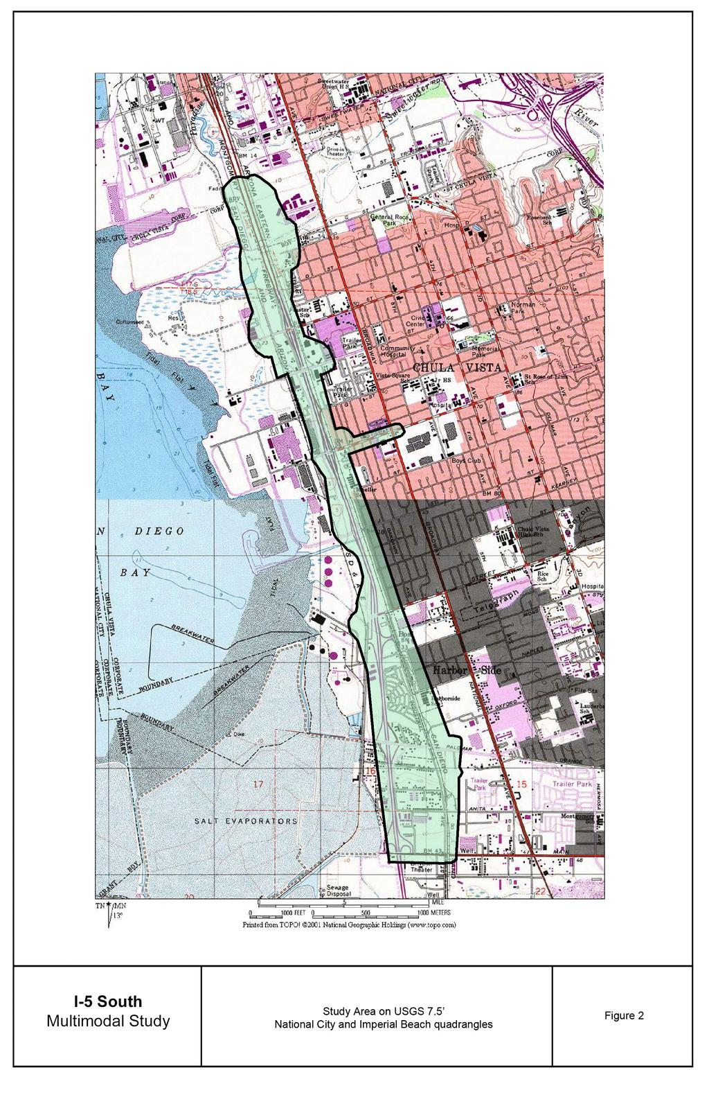
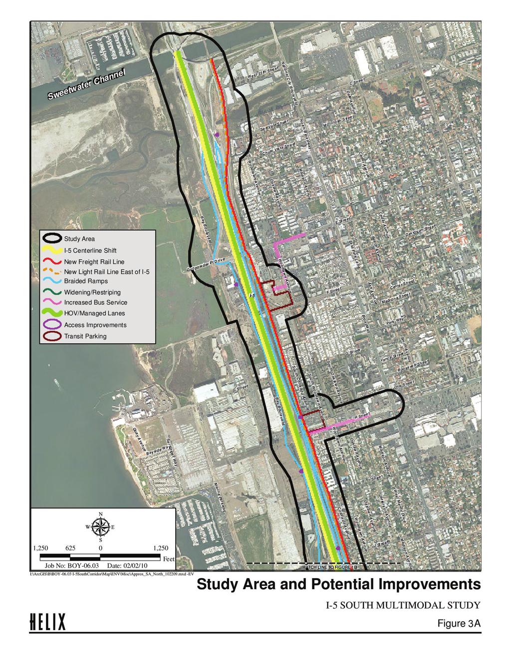
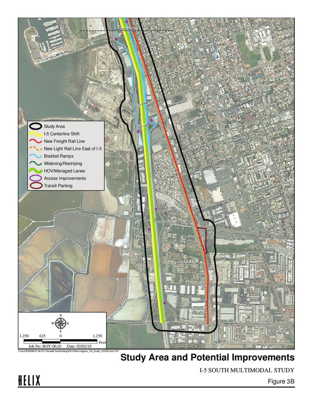
2 847 Jamacha Road, El Cajon, California tel: (619) fax: (619) February 8, 2010 Mr. Bruce McIntyre HELIX Environmental Planning 7578 El Cajon Boulevard La Mesa, California Reference: I-5 South Multimodal Study Cultural Resources Constraints Analysis Mr. McIntyre: Affinis was contracted to conduct a constraints study with regard to cultural resources for the I-5 South Multimodal Project. This letter report addresses the methods and results of the constraints study and summarizes potential cultural resources issues. No significant constraints have been identified related to cultural resources. Introduction The I-5 South Multimodal Project is located in southwestern San Diego County, from the Sweetwater Channel to Main Street in Chula Vista (Figures 1 and 2). The proposed project is intended to evaluate a series of possible transportation improvements along the I-5 corridor through the City of Chula Vista. The overall goal is to identify specific improvements to be included in the 2050 Regional Transportation Plan (RTP), being prepared by the San Diego Association of Area Governments (SANDAG). The primary focus of the project is on improvements related to the existing freeway and transit systems. Improvements to the existing rail system are also considered as a way to promote freight rail operations. Additionally, improvements to specific surface streets within the I-5 corridor are considered including street widening, sidewalks and bike lanes. A general description of each of the major transportation improvements being considered is provided below and illustrated in Figures 3a and 3b. Freeway Improvements Freeway improvements being considered include adding two high occupancy vehicle (HOV) lanes, interchange improvements (e.g. additional turn lanes, auxiliary lanes and modified ramp metering) and a braided ramp system which would interconnect interchanges to minimize the impact on cars getting on and off at the existing closely space interchanges. The possibility of moving the centerline of the freeway to the west to reduce encroachment from freeway and rail improvements into the existing development to east is also considered. 1
3 Transit Improvements Transit improvements being considered include enhancements to existing bus and trolley service. The addition of two new forms of transit (Bus Rapid Transit [BRT] or Arterial Rapid Transit [ART]) is also considered. Location of BRT transit stations within the freeway median are also being considered in conjunction with BRT service. Improvements to trolley service include adding an express trolley during the morning and afternoon peak commute hours, decreased headway intervals, and additional parking at trolley stations. Grade separation is also being considered at major intersections to reduce trolley conflicts with surface street traffic. Freight Rail Improvements Improvements being considered for rail operations would be focused on constructing a third track along the entire length or portions of the study area to allow freight operations to occur independent of trolley operations. This third track would also be used by the express trolley being considered as part of the transit improvements. In addition, several at-grade bypass tracks for freight trains are being considered. Surface Streets Improvements are being considered for H Street between I-5 and Broadway include widening the street from four to six lanes along with a raised median, a Class I bike path and a 16-foot parkway. Additional lanes would also be considered at the I-5 interchange. Non-motorized Improvements Non-motorized improvements include additional and/or enhanced sidewalks as well as improved bike lanes/paths. Figure 3 illustrates the study area and the general components of the combined alternatives. Methods In May 2009, Affinis obtained a records search from the South Coastal Information Center at San Diego State University for the study area and the immediate vicinity. The Native American Heritage Commission was contacted for a check of their Sacred Lands Files in May 2009, and letters were sent to the individuals and groups identified by the Native American Heritage Commission in January A field check of the project study area was conducted in January Geologic maps were checked to ascertain the potential for buried cultural deposits. Records Search Results As summarized in Table 1, nine archaeological and historic resources have been recorded within the project study area. These resources include two isolated flaked stone tools; a sparse scatter of artifacts and shell in a disturbed context; several flakes in a very disturbed area, which could not be found during a later survey; the Paradise Marsh Dump; three railways; and remnants of a World War I era kelp processing plant. 2
4 Table 1 Previously Recorded Sites in the Project Study Area Site Number Site Description Recorder, Year Comments (CA-SDI-) 4886 Isolate scraper Toren, 1977 Not a significant resource 4887 Isolate scraper and shell fragment Toren, Collett and Wade, Not a significant resource. Could not be found in Sparse scatter of flakes, tools, shell. Heavily disturbed; in fill for transmission tower pad 7941 Three flakes. Heavily disturbed 8873H Paradise Marsh Dump most material from 1930s, also some pre- World War I and post- World War II 13,073H Coronado Belt Line railroad 16,385H Burlington Northern Santa Fe (formerly Atchison, Topeka and Santa Fe) Railway Primary Number (P-37-) San Diego and Arizona Railroad 1990 Corum Collett and Wade, 1990 Corum Collett and Wade, 1990 DeCosta and Kupel, Collett and Wade, 1990 Laylander Pigniolo, Pigniolo, 2000 Ballester and Woodard, 2002 Site Description Recorder, Year Comments Wee and Ferrell, Iversen, Pallette, Combined with CA-SDI-6025 in 1990 Could not be found in Not a significant resource No surface indications of the site in 1990, apparently buried; potentially significant Not National Register or California Register eligible but listed on City of San Diego Historic Landmarks (No. 640) Not a significant resource Not a significant resource Hercules Powder Company site World War I era kelp processing plant Craft, 2008 Significant resource National Register and California Register eligible The Hercules Powder Company site (P ) is eligible for the National Register of Historic Places and the California Register of Historical Resources, making it a significant resource. This site includes 13 features, nine of then associated with the World War 1 era kelp processing plant and four of unknown association. Additional elements of past industrial activities at Gunpowder Point were also identified in historic and recent aerial photographs. The site is west of Bay Boulevard, so impacts from the project are not anticipated, but if impacts to the site do occur, they would constitute significant effects. 3
5 The Paradise Marsh Dump site (CA-SDI-8873H) is potentially eligible for the National Register and the California Register, that is, potentially significant under the California Environmental Quality Act (CEQA). This site was recorded as a 20 th century dump, with the majority of material from the 1930s; some material predates World War I, and some post-world War II material was also found. There is no record that the site has been tested to assess its significance. The recorded area of this site has been heavily disturbed by various improvements to the area since its initial mapping in 1981, and the site may no longer exist. No surface indications of the Paradise Marsh Dump site were found during a 1990 survey, but the site record noted that the site might be buried. Based on this, there is a potential for impacts to the site. The Coronado Belt Line railroad (CA-SDI-13,073H) has been determined not eligible for the National Register or the California Register; however, it has been listed by the City of San Diego s Historical Resources Board (City Landmark No. 640). Due to this listing, impacts to this resource would be significant effects under CEQA. No other City along the rail route has designated the Coronado Belt Line as a historic resource (BRG Consulting 2007). Portions of the Coronado Belt Line may be affected by the project. There is no record that site CA-SDI-5512 has been evaluated to assess significance, so the site is potentially a significant resource; however, the disturbed context suggests that the site probably does not retain a high degree of significance. It is anticipated that any impacts to the site could be mitigated to below a level of significance. It should be noted there is another significant historic resource just outside the study area. The Western Salt Company Salt Works (South Bay Salt Works) is located just west of the project study area, at the south end of the project. This resource has been determined to be National Register eligible, so any impacts to it would constitute significant effects. Again, this resource is outside the project study area, but its proximity is important to note in case project plans change and include a larger area to the west. The segment of the San Diego and Arizona Railroad (P ) within the study area does not appear to have been separately addressed, but all other segments of the railroad that been evaluated are not significant resources. This segment also does not appear to be a significant resource. The Burlington Northern Santa Fe (formerly Atchison, Topeka and Santa Fe) Railway (CA-SDI-16,385H) has been determined not to be a significant resource. Impacts to these resources would not constitute significant impacts under CEQA. The isolates and the scatter of three flakes (which could not be found during a later survey) are not significant resources, and impacts to these would not constitute significant effects. Several buildings that are over 50 years old have been recorded in the project study area. These include a group of 10 houses on Dorothy Street, and a house and small gas station at 1196 Industrial Boulevard, all of which have been determined not to be significant resources. There are numerous buildings within the study area that are over 50 years old and have not been evaluated as to historic and architectural significance. While a windshield survey of these buildings suggests that none meet the significance criteria of CEQA, a project specific historic study will be required as part of more detailed environmental review for the project. 4
6 Native American Concerns The Native American Heritage Commission was contacted for a search of their Sacred Lands File. The file check did not indicate the presence of Native American cultural resources within ½ mile of the project study area. Potential for Buried Resources/Secondary Deposits The vast majority of the project area is mapped as alluvial deposits or undocumented fill soils. There is a potential for subsurface cultural resources in these alluvial soils. Buried sites without surface evidence have been identified in alluvial soils along the San Diego River and the San Luis Rey River and numerous other areas. Undocumented fill soils also have the potential to yield archaeological material. In much of the project area the fill soils are probably dredge spoils, which would not be expected to contain cultural material. However, prehistoric and ethnohistoric Kumeyaay habitation sites are known to have been located along San Diego Bay. If soils from these areas (or other areas with cultural material) were used as fill, there is a potential for encountering archaeological material in the fill. CA-SDI-5512, within the study area, was noted as being in fill soils for the pad of a transmission tower. CA-SDI-4630, located west of the project area, in the South Bay Salt Works property, exhibits both cultural material in fill soils and cultural deposits buried by fill (McGinnis et al. 2006). While context is important for understanding archaeological resources, sensitive cultural materials, such as human remains or culturally significant artifacts, have been encountered in fill soils in the past. As part of project specific studies, the archaeological consultant should review geotechnical studies and work with the geotechnical consultant to determine specific areas that have potential for encountering such secondary deposits in fill soils. Conclusions Several historic and archaeological resources have been identified within the project study area. While most of these are not significant resources, impacts to a few of the resources would constitute significant effects under CEQA and under federal regulations. In addition, there is a potential for subsurface cultural resources in alluvial areas and for cultural material in some undocumented fill soils. No Native American concerns have been identified. Project specific studies should be conducted once alignments are refined, but based on the information available for this study, there do not appear to be any unmitigable impacts associated with cultural resources. If you have any questions, you can reach me at (619) extension 18 or mary@affinis.net. Mary Robbins-Wade, RPA Director of Cultural Resources 5
7 References BRG Consulting 2007 Environmental Impact Report for the Proposed Bayshore Bikeway Western Salt Segment. BRG Consulting, San Diego. Report prepared for City of San Diego, Development Services Department. McGinnis, Patrick M., Andrew Pigniolo, and Stephanie Murray 2006 Cultural Resources Survey and Testing Report for the Bayshore Bikeway Project, Imperial Beach, California. Tierra Environmental Services, San Diego. Report submitted to City of San Diego, Development Services. Report on file at South Coastal Information Center, San Diego State University. 6
8
9
10
11
Draft Environmental Assessment Appendix A. SHPO Correspondence, January 19, 2017
 Draft Environmental Assessment Appendix A. SHPO Correspondence, January 19, 2017 Rosecrans/Marquardt Grade Separation Project April 2018 Federal Railroad Administration U.S. Department 1200 New Jersey
COASTAL CONSERVANCY. Staff Recommendation November 9, 2006 WESTERN SALT WORKS SITE ASSESSMENT AND SOUTH SAN DIEGO BAY TRAIL LINKAGES
 COASTAL CONSERVANCY Staff Recommendation November 9, 2006 WESTERN SALT WORKS SITE ASSESSMENT AND SOUTH SAN DIEGO BAY TRAIL LINKAGES File No. 06-081 Project Manager: Prentiss Williams RECOMMENDED ACTION:
2.1.8 Cultural Resources Regulatory Setting. Affected Environment, Environmental
 REVISED DRAFT ENVIRONMENTAL IMPACT REPORT/ Affected Environment, Environmental 2.1.8 Cultural Resources This section evaluates the potential for historical and archaeological resources within the proposed
2. AGENCY COORDINATION AND PUBLIC INVOLVMENT
 2. AGENCY COORDINATION AND PUBLIC INVOLVMENT This chapter discusses the process carried out for conducting agency coordination and public involvement activities. TECHNICAL ADVISORY COMMITTEE A Technical
SBCAG STAFF REPORT. MEETING DATE: March 17, 2016 AGENDA ITEM: 5I
 SBCAG STAFF REPORT SUBJECT: Cabrillo-UPRR Bridge Project MEETING DATE: March 17, 2016 AGENDA ITEM: 5I STAFF CONTACT: Fred Luna RECOMMENDATION: Authorize the chair to sign a Memorandum of Understanding
Mavis Road Class Environmental Assessment
 Mavis Road Class Environmental Assessment Public Information Centre #2 Wednesday November 9, 2016 6:00 to 8:00 p.m. Please sign in and complete a comment sheet Review the displays on your own or join in
3.4.5 Roadway System and Infrastructure Phase I (Project) Roadway System Components E Street Extension (Phase I).
 Roadway System Components E Street Extension (Phase I).") 3.4.5 Roadway System and Infrastructure Roadway demolition, road improvements, roadway realignments, and construction of new roads, as well as utility infrastructure improvements, transit, as well as pedestrian
3.4.5 Roadway System and Infrastructure Roadway demolition, road improvements, roadway realignments, and construction of new roads, as well as utility infrastructure improvements, transit, as well as pedestrian
STAGE 1 ARCHAEOLOGICAL ASSESSMENT OF RATHBURN ROAD, FROM DUKE OF YORK BOULEVARD TO SHIPP DRIVE, CITY OF MISSISSAUGA. Submitted to:
 STAGE 1 ARCHAEOLOGICAL ASSESSMENT OF RATHBURN ROAD, FROM DUKE OF YORK BOULEVARD TO SHIPP DRIVE, CITY OF MISSISSAUGA Submitted to: McCormick Rankin Corporation 2655 North Sheridan Way, Suite 280 Mississauga,
Appendix G. Archaeological and Paleontological Resources Records Searches
 Appendix G Archaeological and Paleontological Resources Records Searches South Central Coastal Information Center California State University, Fullerton Department of Anthropology MH-426 800 North State
2017 General Obligation Bond
 2017 General Obligation Bond Presentation of Public and Council Projects to the Transportation & Mobility Stakeholder Committee April 13, 2017 Agenda Deferred Maintenance Project Development Process Projects
Historic and Cultural Resources
 Chapter 4: Historic and Cultural Resources 4.1 INTRODUCTION This chapter assesses the potential effects to historic structures and archaeological resources as a result of the construction and operation
Final Initial Study. Chalice Unitarian Universalist Congregation Conditional Use Permit
 5 Final Initial Study Chalice Unitarian Universalist Congregation Conditional Use Permit Appendix B Chalice Unitarian Universalist Congregation Cultural Resources Memorandum TRC 9685 Research Drive Irvine,
APPENDIX J SHPO COORDINATION
 Final Environmental Impact Statement/Final Environment Impact Report Appendix J SHPO Coordination APPENDIX J SHPO COORDINATION August 2011 CRENSHAW/LAX TRANSIT CORRIDOR PROJECT Final Environmental Impact
Eastern Terminus TECHNICAL MEMORANDUM CENTRAL BROWARD EAST-WEST TRANSIT ANALYSIS BROWARD COUNTY, FLORIDA
 Eastern Terminus TECHNICAL MEMORANDUM CENTRAL BROWARD EAST-WEST TRANSIT ANALYSIS BROWARD COUNTY, FLORIDA FINANCIAL PROJECT ID NUMBER 411189-2-22-01 FLORIDA DEPARTMENT OF TRANSPORTATION DISTRICT 4 Prepared
Project Description. Dear Ms. Roland-Nawi:
 U.S. Department of Transportation Federal Transit Administration REGION IX Arizona, California, Hawaii, Nevada, Guam American Samoa, Northern Mariana Islands 201 Mission Street Suite 1650 San Francisco,
Archaeological Resources Supplemental Survey Technical Report
 ` Archaeological Resources Supplemental Survey Technical Report March 2012 THIS PAGE INTENTIONALLY LEFT BLANK NATIONAL ARCHAEOLOGICAL DATABASE (NADB) INFORMATION Authors Consulting Firm Nancy E. Sikes,
WELCOME TO OPEN HOUSE TWO November 28, 2018
 Langstaff Road Weston Road to Highway 7 Class Environmental Assessment Study WELCOME TO OPEN HOUSE TWO November 28, 2018 Please sign in and join our mailing list Study Overview York Region is conducting
Eastside Transit Corridor Phase 2 Technical Study Update Community Outreach Meeting February 2017
 Eastside Transit Corridor Phase 2 Technical Study Update Community Outreach Meeting February 2017 Purpose of Tonight s Meeting Recap of Board motion (2014) and technical study process Provide update on
LOS ANGELES COUNTY METROPOLITAN TRANSPORTATION AUTHORITY (LACMTA)
") CE OF PREPARAT LOS ANGELES COUNTY METROPOLITAN TRANSPORTATION AUTHORITY (LACMTA) NOTICE OF PREPARATION OF AN ENVIRONMENTAL IMPACT STATEMENT (E1S)lENVIRONMENTAL IMPACT REPORT (EIR) TO: AGENCIES, ORGANIZATIONS
CE OF PREPARAT LOS ANGELES COUNTY METROPOLITAN TRANSPORTATION AUTHORITY (LACMTA) NOTICE OF PREPARATION OF AN ENVIRONMENTAL IMPACT STATEMENT (E1S)lENVIRONMENTAL IMPACT REPORT (EIR) TO: AGENCIES, ORGANIZATIONS
Call to Artists Public Art for Los Angeles Metro Stations
 Conceptual Design for Call to Artists Public Art for Los Angeles Metro Stations Artesia Transit Center Union Station/Patsaouras Transit Plaza Los Angeles County Metropolitan Transportation Authority February
ARLINGTON COUNTY, VIRGINIA. County Board Agenda Item Meeting of January 28, 2017 SUPPLEMENTAL REPORT
 ARLINGTON COUNTY, VIRGINIA County Board Agenda Item Meeting of January 28, 2017 SUPPLEMENTAL REPORT DATE: January 26, 2017 SUBJECT: The Virginia Department of Transportation s Transform I-66 Inside the
2. INTRODUCTION 2.1 AUTHORITY 2.2 PURPOSE AND INTENT 2.3 SITE LOCATION
 2. INTRODUCTION 2.1 AUTHORITY The City of Gardena initiated and prepared the Artesia Corridor Specific Plan pursuant to the provisions of California Government Code, Title 7, Division 1, Chapter 3, Article
NOTICE OF PREPARATION
 NOTICE OF PREPARATION To: All Interested Parties Subject: Notice of Preparation of an Environmental Impact Report From: City of Petaluma Address: 11 English Street, Petaluma, CA 94952-2610 Contact: Heather
Public Review Draft Oceanside Subarea Habitat Conservation Plan/ Natural Communities Conservation Plan
 Oceanside Subarea Habitat Conservation Plan/ Natural Communities Conservation Plan Prepared for City of Oceanside Planning Department 300 N. Coast Highway Oceanside, CA 92054 Prepared by Ogden Environmental
APPENDIX D: Visual and Aesthetic Conditions for NCCU Station Refinement. Durham-Orange Light Rail Transit Project
 APPENDIX D: Visual and Aesthetic Conditions for NCCU Station Refinement Durham-Orange Light Rail Transit Project October 2016 1. Introduction The Combined FEIS/ROD summarizes the effects of the D-O LRT
ARLINGTON COUNTY, VIRGINIA. County Board Agenda Item Meeting of January 28, 2017 SUPPLEMENTAL REPORT-2
 ARLINGTON COUNTY, VIRGINIA County Board Agenda Item Meeting of January 28, 2017 SUPPLEMENTAL REPORT-2 DATE: January 27, 2017 SUBJECT: The Virginia Department of Transportation s Transform I-66 Inside the
V. ENVIRONMENTAL IMPACT ANALYSIS D. CULTURAL RESOURCES
 V. ENVIRONMENTAL IMPACT ANALYSIS D. CULTURAL RESOURCES Incorporated into this section are the findings and conclusions of two archaeological investigations conducted on the Project Site: a site survey
PRIMARY RECORD Trinomial # NRHP Status Code 3S, 3CS, 5S3 Other Listings Review Code Reviewer Date
 PRIMARY RECORD # NRHP Status Code 3S, 3CS, 5S3 Other Listings Review Code Reviewer Date Page 1 of 6 1252 *Resource Name or # (Assigned by recorder) Old Topanga Canyon Road P1. Other Identifier: *P2. Location:
I. DESCRIPTION OF PROPOSED ACTION... 1 A. General Description... 1 B. Historical Resume and Project Status... 2 C. Cost Estimates...
 PROJECT COMMITMENTS SUMMARY... S-1 1. Type of Action... S-1 2. Description of Action... S-1 3. Summary of Purpose and Need... S-1 4. Alternatives Considered... S-2 5. NCDOT Alternatives Carried Forward...
Bypass #16 - Bend Parkway (new alignment for US 97) (MP )
 (MP )") Bypass #16 - Bend Parkway (new alignment for US 97) (MP 134.76-141.83) Description: The Parkway is on new alignment for US 97 through Bend. US 97 is a Statewide Highway on the National Highway System that
Bypass #16 - Bend Parkway (new alignment for US 97) (MP 134.76-141.83) Description: The Parkway is on new alignment for US 97 through Bend. US 97 is a Statewide Highway on the National Highway System that
SECTION 4(f) DE MINIMIS DOCUMENTATION
 DE MINIMIS DOCUMENTATION") SECTION 4(f) DE MINIMIS DOCUMENTATION Illinois Route 60/83 IL 176 to the intersection of IL 60 (Townline Road) Lake County P-91-084-07 Mundelein Park and Recreation District Project Limit SECTION 4(f)
SECTION 4(f) DE MINIMIS DOCUMENTATION Illinois Route 60/83 IL 176 to the intersection of IL 60 (Townline Road) Lake County P-91-084-07 Mundelein Park and Recreation District Project Limit SECTION 4(f)
THE PLANNING AREA 2.1 PLANNING AREA LOCATION
 2. The Planning Area Brisbane Baylands Specific Plan 21 2 THE PLANNING AREA 2.1 PLANNING AREA LOCATION The Baylands is located approximately midway between San Francisco s central business district and
California Environmental Quality Act (CEQA) Environmental Review Process
 Environmental Review Process") California Environmental Quality Act (CEQA) Environmental Review Process Los Angeles Union Station Forecourt and Esplanade Improvements constitute a Project Los Angeles County Metropolitan Transportation
California Environmental Quality Act (CEQA) Environmental Review Process Los Angeles Union Station Forecourt and Esplanade Improvements constitute a Project Los Angeles County Metropolitan Transportation
North Carolina Department of Transportation Project Development and Environmental Analysis Branch
 North Carolina Department of Transportation Project Development and Environmental Analysis Branch Citizens Informational Workshop I-85, from I-485 to NC 73 Mecklenburg and Cabarrus Counties October 30,
11.0 TRANSPORTATION ELEMENT
 11.0 TRANSPORTATION ELEMENT Transit, Circulation and Parking Sub-Element: For all campuses, FIU's goal is to increase multimodal access. In combination with other measures - such as the development of
Right-of-Way Acquisitions and Relocations Technical Memorandum
 Right-of-Way Acquisitions and Relocations Technical Memorandum Southeast Extension Project Lincoln Station to RidgeGate Parkway Prepared for: Federal Transit Administration Prepared by: Denver Regional
Appendix C Cultural Resources Analysis for Asphalt Plant No. 1
 Appendix C Cultural Resources Analysis for Asphalt Plant No. 1 TECHNICAL MEMORANDUM Cultural Resources Analysis for Asphalt Plan No. 1 PREPARED FOR: PREPARED BY: City of Los Angeles, Department of Public
Portage Parkway Environmental Assessment Public Information Centre No. 1
 City of Vaughan Portage Parkway Environmental Assessment Public Information Centre No. 1 November 25, 2015 Welcome to the Public Information Centre This first Public Information Centre (PIC) introduces
St. Clair Avenue West Area Transportation Master Plan
 1 (Between Keele Street and Old Weston Road) Public Information Centre 1 December 2, 2015 2 Welcome Welcome to the first Public Information Centre for the St. Clair Avenue West Area. The panels will present
W.H. Bonner Associates
 15619 Ogram Avenu Gardena, CA 90249-444 W.H. Bonner Associates Archaeofaunal Studies Archaeological Surveys Historical & Genealogical Research (310) 675-274 E-mail: whbonner@aol.com April 21, 2014 Wendy
City of Larkspur. Notice of Mitigated Negative Declaration for the 285
 Notice of Mitigated Negative Declaration for the 285 Magnolia Avenue Mixed-Use Project Date: December 2, 2013 Responsible Agency: Project Title: 285 Magnolia Avenue Mixed-Use Project Project Address: 285
Table of Contents J.2 Cultural Resources - Archaeological Resources
 Table of Contents J.2 Cultural Resources - Archaeological Resources 1. INTRODUCTION... 1642 2. ENVIRONMENTAL SETTING... 1642 a. Regulatory Setting... 1642 (1) State... 1642 (2) Local... 1644 (3) Native
NORTH-SOUTH CORRIDOR STUDY EXECUTIVE SUMMARY. Executive Summary
 Executive Summary Background As congestion continues to affect mobility in the region, the Ozarks Transportation Organization (OTO) is particularly concerned with traffic movement. The North-South Corridor
3.10 LAND USE SETTING PROJECT SITE EXISTING LAND USE DESIGNATIONS AND ZONING. General Plan Land Use Designations.
 This section of the Draft EIR addresses the existing land uses on and adjacent to the project site and discusses the potential impacts of the proposed project on existing land uses. Key issues addressed
St. Laurent Transit Improvements Innes / Industrial to Smyth. Public Information Session December 2, 2015
 St. Laurent Transit Improvements Innes / Industrial to Smyth Public Information Session December 2, 2015 Agenda Introduction Project Background Preliminary Design Widening for transit lanes Roadway resurfacing
McKay Road Interchange and Salem / Lockhart Crossing
 McKay Road Interchange and Salem / Lockhart Crossing The McKay Road Interchange Class EA has two components: 1. A new MacKay Road Interchange at Highway 400; and 2. A new bridge crossing of Highway 400
4.1 AESTHETICS AND VISUAL QUALITY
 SCOPE AND METHODOLOGY 4.1 AESTHETICS AND VISUAL QUALITY This section evaluates the potential impacts to aesthetics and visual quality. Aesthetics refers to visual resources and the quality of what can
1.0 Introduction. Purpose and Basis for Updating the TMP. Introduction 1
 1.0 Introduction The Town of Castle Rock is situated between the metropolitan areas of Denver and Colorado Springs, amidst a unique terrain of rolling hills, mesas, ravines, and waterways. Like many Front
Visual and Aesthetics
 Such a connection could accommodate timed transfers and improve connections between local transit service and Presidio Shuttle service. Level of Service The results of the analysis are provided on a route-by-route
Notice of Preparation (NOP) of an Environmental Impact Report and Public Scoping Meeting for the Alameda Shipways Residential Project
 of an Environmental Impact Report and Public Scoping Meeting for the Alameda Shipways Residential Project") Notice of Preparation (NOP) of an Environmental Impact Report and Public Scoping Meeting for the Notice is hereby given that the City of Alameda, Lead Agency, will prepare an Environmental Impact Report
Notice of Preparation (NOP) of an Environmental Impact Report and Public Scoping Meeting for the Notice is hereby given that the City of Alameda, Lead Agency, will prepare an Environmental Impact Report
AN ARCHAEOLOGICAL SURVEY FOR THE RICHARDS, TEXAS FARM-TO-MARKET ROAD 149 FIBER OPTIC CABLE PROJECT IN MONTGOMERY COUNTY, TEXAS
 AN ARCHAEOLOGICAL SURVEY FOR THE RICHARDS, TEXAS FARM-TO-MARKET ROAD 149 FIBER OPTIC CABLE PROJECT IN MONTGOMERY COUNTY, TEXAS Antiquities Permit 6097 By William E. Moore Brazos Valley Research Associates
4.0 AFFECTED ENVIRONMENT AND ENVIRONMENTAL CONSEQUENCES
 4.0 AFFECTED ENVIRONMENT AND ENVIRONMENTAL CONSEQUENCES The following sections discuss the impacts associated with environmental resources for the tunneling method Alternatives A and B. The construction
City of Cornwall Municipal Class Environmental Assessment. Proposed Improvement and Extension of Lemay Street
 Welcome City of Cornwall Municipal Class Environmental Assessment Proposed Improvement and Extension of Lemay Street Redevelopment and Design of the Municipal Works Yard Public Information Centre #1 Thursday,
4/8/2015 Item #10D Page 1
 MEETING DATE: April 8, 2015 PREPARED BY: Christy Villa, Associate Civil Engineer DEPT. DIRECTOR: Glenn Pruim DEPARTMENT: Public Works CITY MANAGER: Larry Watt SUBJECT: NORTH COAST HIGHWAY 101 STREETSCAPE
1.0 Circulation Element
 5/9/18 1.0 Circulation Element 1.1 Introduction As growth and development occur in Apache County, enhancements to its circulation system will be necessary. With time, more roads will be paved and air and
Clay Street Bridge Replacement Project
 Clay Street Bridge Replacement Project Frequently Asked Questions (FAQs) No. 2 April 4, 2018 The project is located in downtown Placerville on Clay Street between US Highway 50 and Main Street and Cedar
IOWA HIGHWAY 57 / WEST 1 ST STREET STUDY PUBLIC INFORMATIONAL MEETING APRIL 22, 2014
 IOWA HIGHWAY 57 / WEST 1 ST STREET STUDY PUBLIC INFORMATIONAL MEETING APRIL 22, 2014 INTRODUCTION The City of Cedar Falls and the Iowa Department of Transportation are conducting a Public Informational
Transportation. Strategies for Action
 Transportation A major priority for the Overlake Neighborhood is to develop a multimodal transportation system. To achieve this system, a balance has to be found among travel, circulation and access needs;
7.5 Impacts on the Section 4(f) Properties
 Properties") constructive use, such as noise, air quality and visual impacts were also assessed. It was determined that this project would not introduce changes of an external nature that would affect the recreational
constructive use, such as noise, air quality and visual impacts were also assessed. It was determined that this project would not introduce changes of an external nature that would affect the recreational
Issues Requiring Future Study
 Issues Requiring Future Study Transportation planning is an ongoing process that tends to identify new issues as it finds solutions for others. Some issues are so complex that a solution to one problem
WELCOME TO OPEN HOUSE # 3
 Bayview Avenue Class Environmental Assessment Study Steeles Avenue to Elgin Mills Road WELCOME TO OPEN HOUSE # 3 Please sign in and join our mailing list Why Are We Here Tonight? Study Process and Purpose
City Of Sparks Planning Commission Item
 Page 1 of 12 City Of Sparks Planning Commission Item Meeting Date: May17, 2012 Subject: PCN12009, Public Hearing, Consideration and possible action on a Master Plan Amendment and Rezoning request to change
ARCHAEOLOGICAL INVESTIGATIONS FOR THE OLD DAVIS ROAD REALIGNMENT PROJECT ON THE UNIVERSITY OF CALIFORNIA, DAVIS CAMPUS YOLO COUNTY, CALIFORNIA
 Cultural Resources Consultants ARCHAEOLOGICAL INVESTIGATIONS FOR THE OLD DAVIS ROAD REALIGNMENT PROJECT ON THE UNIVERSITY OF CALIFORNIA, DAVIS CAMPUS YOLO COUNTY, CALIFORNIA Prepared for: Matt Dulcich,
Metro Orange Line Extension Four Years Early and $61 Million Under Budget
 White Paper: Metro Orange Line Extension Four Years Early and $61 Million Under Budget July 2013 Innovation for better mobility Metro Orange Line Extension Iteris, Inc. was the prime consultant leading
Appendix G Response to Comments
 Appendix G Response to Comments This appendix contains the comments received during the public circulation and comment period (May 27, 2008 to July 11, 2008). The comments have been numbered (Comment Set
3.1 AESTHETICS Background and Methodology
 3.1 AESTHETICS 3.1.1 Background and Methodology 3.1.1.1 Regulatory Context The California Environmental Quality Act (CEQA) requires that project sponsors evaluate the project s potential to cause aesthetic
Project Study Report Equivalent The Old Road Widening SIX FLAGS MAGIC MOUNTAIN. On Street The Old Road Between Magic Mountain Pkwy And Turnberry Lane
 Project Study Report Equivalent The Old Road Widening SIX FLAGS MAGIC MOUNTAIN On Street The Old Road Between Magic Mountain Pkwy And Turnberry Lane On Street Henry Mayo Drive Between The Old Road And
Better Cycling. The City will update the cycling master plan (London ON Bikes) based on the approved BRT network.
 based on the approved BRT network.") Better Cycling Dedicated bike facilities will be constructed along BRT corridors where space is available. Nearby bike routes will also be upgraded to ensure a complete network is available for cyclists.
Better Cycling Dedicated bike facilities will be constructed along BRT corridors where space is available. Nearby bike routes will also be upgraded to ensure a complete network is available for cyclists.
Table of Contents TABLE OF CONTENTS SECTION TITLE PAGE
 TABLE OF CONTENTS SECTION TITLE PAGE 1 INTRODUCTION AND OVERVIEW 1-1 1.1 Purpose and Need 1-1 1.2 Goals and Objectives 1-3 1.3 Overview of the Planning Process 1-5 1.4 Federal and State Requirements and
ONTARIO MUNICIPAL BOARD
 PL 120483 ONTARIO MUNICIPAL BOARD Applicant/Appellant: 2124123 Ontario Limited Subject: OPA, Rezoning and Draft Plan of Subdivision Municipal Address: 3940 Highway 7 East Municipality: City of Markham
Alta Vista Transportation Corridor Environmental Study Report November 2005
 Alta Vista Transportation Corridor Environmental Study Report November 2005 6.0 ALTERNATIVE DESIGNS The Preferred Solution to providing additional transportation system capacity through the AVTC study
Burloak Drive Grade Separation
 Burloak Drive Grade Separation Transit Project Assessment Process Public Meeting #1 March 30, 2017 GO Lakeshore West Service Plan Weekday Rush Hour 15-minute, two-way service between Aldershot* and Union
Cotton Belt Regional Rail Corridor Project
 Cotton Belt Regional Rail Corridor Project North Dallas AFG University of Texas at Dallas Administration Building March 1, 2018 0 Discussion Public Involvement Project Scope Alignment Stations Environmental
ARGENTA TRAIL (CSAH 28/63) REALIGNMENT SOUTH PROJECT (CP 63-25)
 REALIGNMENT SOUTH PROJECT (CP 63-25)") ARGENTA TRAIL (CSAH 28/63) REALIGNMENT SOUTH PROJECT (CP 63-25) Preliminary Design Report February 2015 Prepared For: City of Inver Grove Heights Dakota County Prepared By: Kimley-Horn and Associates,
ARGENTA TRAIL (CSAH 28/63) REALIGNMENT SOUTH PROJECT (CP 63-25) Preliminary Design Report February 2015 Prepared For: City of Inver Grove Heights Dakota County Prepared By: Kimley-Horn and Associates,
East River Waterfront Esplanade and Piers New York, New York Draft Environmental Impact Statement
 East River Waterfront Esplanade and Piers New York, New York Draft Environmental Impact Statement October 12, 2006 CEQR No.: TO COME ULURP Nos.: TO COME Lead Agency: Lower Manhattan Development Corporation
4.500 Preston Road Overlay District
 Section 4.500 Preston Road Overlay District 2004 Zoning Ordinance 4.500 Preston Road Overlay District (ZC 98-29; Ordinance No. 98-9-12) 4.501 Purpose To provide appropriate design standards for the use
ALTERNATIVES. NCDOT made an early decision to first determine how to build the project (construction method) followed by what to build (alternatives).
 followed by what to build (alternatives).") III. ALTERNATIVES A. CONSTRUCTION METHOD ALTERNATIVES NCDOT made an early decision to first determine how to build the project (construction method) followed by what to build (alternatives). One of the
III. ALTERNATIVES A. CONSTRUCTION METHOD ALTERNATIVES NCDOT made an early decision to first determine how to build the project (construction method) followed by what to build (alternatives). One of the
Figure 5. Previously Identified Viable Corridors
 OVERVIEW The Central Florida Expressway Authority (CFX) is evaluating the potential to expand SR 408 from its current eastern terminus along SR 50 to SR 520 in northeastern Orange County, Fl. This new
To qualify for federal Transportation Enhancement (TE) funds a project must meet two basic federal requirements:
 funds a project must meet two basic federal requirements:") Eligibility Requirements To qualify for federal Transportation Enhancement (TE) funds a project must meet two basic federal requirements: 1) Relate to surface transportation and 2) Be one of the 12 designated
Eligibility Requirements To qualify for federal Transportation Enhancement (TE) funds a project must meet two basic federal requirements: 1) Relate to surface transportation and 2) Be one of the 12 designated
COACHELLA VALLEY ASSOCIATION OF GOVERNMENTS NOTICE OF PREPARATION OF A PROGRAM ENVIRONMENTAL IMPACT REPORT AND PUBLIC SCOPING MEETING
 COACHELLA VALLEY ASSOCIATION OF GOVERNMENTS NOTICE OF PREPARATION OF A PROGRAM ENVIRONMENTAL IMPACT REPORT AND PUBLIC SCOPING MEETING Date of Notice: November 12, 2013 To: From: Michael Shoberg Transportation
2016 REVISIONS COMMENT FORM RULES AND REGULATIONS FOR CONSTRUCTION IN THE PUBLIC WAY COMMENT PERIOD: JUNE 1 TO JUNE 30, 2015
 AGENCY: 2016 REVISIONS COMMENT FORM Section Title Number Chapter 1 Introduction Comment 1.1 CDOT Mission Statement 1.2 Purpose of Rules and Regulations for Construction in the Public Way 1.3 Chicago Department
The Anaheim Resort Public Realm Landscape Program. City of Anaheim. Adopted September 1994 (94R-239)
") Public Realm Landscape Program City of Anaheim Adopted September 1994 (94R-239) Amendment No. 1 October 1996 (96R-178) Amendment No. 2 June 1999 (99R-137) Amendment No. 3 February 2001 (2002R-56) Amendment
Public Realm Landscape Program City of Anaheim Adopted September 1994 (94R-239) Amendment No. 1 October 1996 (96R-178) Amendment No. 2 June 1999 (99R-137) Amendment No. 3 February 2001 (2002R-56) Amendment
ITEM #8. Regional Smart Growth Program. Regional Smart Growth Program. Presentation Overview. Coast Highway Vision and Stategic Plan.
 Regional Smart Growth Program Economic Development Commission What is Smart Growth? Adopted as part of the Regional Comprehensive Plan (RCP) RCP provides vision for region based on Smart Growth and sustainability
Mississippi Skyway Preliminary Engineering Report
 EXECUTIVE SUMMARY Mississippi Skyway Preliminary Engineering Report CITY OF RAMSEY, MINNESOTA DECEMBER 2014 City of RAMSEY EXECUTIVE SUMMARY Project Need and Intent The Mississippi Skyway pedestrian bridge
BROOKE PETERSON, AICP Associate Principal
 BROOKE PETERSON, AICP Brooke s career includes a wide range of long-range policy planning, development project planning, urban design, and environmental planning experience for both the public and private
Welcome. Northern Segment of Hwy 100 I-90 to South of Madison Street Meeting Goals:
 Welcome Northern Segment of Hwy 100 I-90 to South of Madison Street Meeting Goals: - Review Environmental Assessment - Share Preferred Alternative -Receive Public Comments 2003 EA Preferred Alternative
INFRASTRUCTURE EXISTING INFRASTRUCTURE A. Circulation B. Signals C. Drainage D. Utilities
 7.01. EXISTING INFRASTRUCTURE A. Circulation B. Signals C. Drainage D. Utilities 7.02. PROPOSED INFRASTRUCTURE A. Overall Concept B. Circulation C. Signals D. Drainage 7.03. INFRASTRUCTURE MAP A. Key Infrastructure
SAN FRANCISCO MUNICIPAL TRANSPORTATION AGENCY
 THIS PRINT COVERS CALENDAR ITEM NO. : 10.3 DIVISION: Sustainable Streets BRIEF DESCRIPTION: SAN FRANCISCO MUNICIPAL TRANSPORTATION AGENCY Approving the removal of Municipal Railway bus zones at various
ROSEMONT 138kV TRANSMISSION LINE PROJECT. Public Open House Meeting #2 August 27, 2009
 ROSEMONT 138kV TRANSMISSION LINE PROJECT Public Open House Meeting #2 August 27, 2009 Project Overview Tucson Electric Power (TEP), as a part of its obligation to serve, is proposing to construct and operate
Los Angeles Department of City Planning RECOMMENDATION REPORT
 Los Angeles Department of City Planning RECOMMENDATION REPORT CULTURAL HERITAGE COMMISSION HEARING DATE: April 15, 2010 TIME: 10:00 AM PLACE: City Hall, Room 1010 200 N. Spring Street Los Angeles, CA 90012
Planning Commission Staff Report March 15, 2007
 Planning Commission Staff Report Project: Request: Madeira East Tentative Subdivision Map, Design Review for Subdivision Layout & Abandonment of Easements Location: Phase IV of the Laguna Ridge Specific
UNIVERSITY OF CALIFORNIA, SAN DIEGO
 UNIVERSITY OF CALIFORNIA, SAN DIEGO BERKELEY DAVIS IRVINE LOS ANGELES MERCED RIVERSIDE SAN DIEGO SAN FRANCISCO SANTA BARBARA SANTA CRUZ CAMPUS PLANNING 9500 GILMAN DRIVE # 0074 TEL: (858) 534 6515 LA JOLLA,
Historic and Archaeological Resources
 Historic and Archaeological Resources 8. INTRODUCTION This chapter assesses the potential effects to architectural (i.e., historic) and archaeological resources as a result of the construction and operation
EXECUTIVE SUMMARY. Introduction
 EXECUTIVE SUMMARY Introduction State Route 68 is a designated scenic route that connects the world-renowned Monterey Peninsula to US Highway 101 and the Salinas Valley. SR 68 is a key route for bicycle,
South Davis County COMMUNITY SPOTLIGHT
 South Davis County COMMUNITY SPOTLIGHT Davis/SLC Community Connector Bus Rapid Transit line connecting SLC & Davis County RTP Phase 1 Project Generate 3,100 average weekday riders Relieve congestion on
COASTAL CONSERVANCY. Staff Recommendation June 5, 2008 SAN DIEGO RIVER TRIBUTARY CANYONS PROJECT. File No Project Manager: Megan Johnson
 COASTAL CONSERVANCY Staff Recommendation June 5, 2008 SAN DIEGO RIVER TRIBUTARY CANYONS PROJECT File No. 08-059 Project Manager: Megan Johnson RECOMMENDED ACTION: Authorization to disburse an amount not
16E. 24 th Street Corridor. A. Background
 A. Background The 24 th Street corridor plan includes both 24 th Street and 2550 South from 1900 West to Washington Boulevard, as shown in Map 1. 1. Development History The 24 th Street Corridor has been
STAFF REPORT FOR STANDARD COASTAL DEVELOPMENT PERMIT #CDP FEBRUARY 26, 2015 CPA - 1 PO BOX 238 APTOS, CA 94001
 STAFF REPORT FOR STANDARD COASTAL DEVELOPMENT PERMIT #CDP 2014-0030 FEBRUARY 26, 2015 CPA - 1 OWNER/APPLICANT: AGENT: REQUEST: HANS HEIM PO BOX 238 APTOS, CA 94001 JAMES HAY PO BOX 762 MENDOCINO, CA 95460
2290+ STADIUM VILLAGE STATION ABOVE FIELD) (T.O "
 (T.O") 1 + PROPOSED o.8 UROU 3 15 + 32+ 32 CROSS-OVER PROPOSED o.8 PROPOSED o.8 CROSS-OVER DOUBLE at H ia ha LR w 1:1 33 + 3 5+ 33 34 h:\projects\\hi-mu\layou\feasibiliy SUDY\Enhanced\_alignment_comparison.dgn
1 + PROPOSED o.8 UROU 3 15 + 32+ 32 CROSS-OVER PROPOSED o.8 PROPOSED o.8 CROSS-OVER DOUBLE at H ia ha LR w 1:1 33 + 3 5+ 33 34 h:\projects\\hi-mu\layou\feasibiliy SUDY\Enhanced\_alignment_comparison.dgn
City of Los Angeles, Bureau of Engineering staff report - dated October 14, 2009 and the Hearing Examiner Report signed October 21, 2009.
 - the Rifkin Transportation Los Feliz Towers 4455 Los Feliz Boulevard Suite 1403 Planning Group E-mail allynrifkin@gmail.com Telephone and fax -- (323) 664-2805 Mobile phone - (323) 697-1594 February 3,