R E P O R T DEVELOPMENT SERVICES DEPARTMENT
|
|
|
- Nora Fletcher
- 5 years ago
- Views:
Transcription
1 City of New Westminster R E P O R T DEVELOPMENT SERVICES DEPARTMENT To: From: Members of the Advisory Planning Commission Lynn Roxburgh, Planner Rupinder Basi, Senior Planner Date: August 19, 2014 File: OCP0009 Subject: Proposed Official Community Plan Amendment and Development of Master Plan for the Queensborough Special Study Area PURPOSE The purpose of this report is to provide the Advisory Planning Commission with information on the proposed Queensborough Special Study Area Master Plan process. The Special Study Area is defined as the area bound by Ewen Avenue, Stanley Street, Duncan Street and Furness Street (see Appendix 1). The redevelopment of the subject site will require an amendment of the Official Community Plan (OCP) in order to change the land use designation and to create a new Development Permit Area and design guidelines for the portion of the Special Study Area designated Queensborough Comprehensive Development. Community engagement on this project is already underway, and the purpose of this report is to bring the Advisory Planning Commission up to date on the proposal. SITE INFORMATION Applicant / Developer: Current Zoning: OCP Land Use Designation Development Permit Area: Overall Study Area: Area of properties owned by Platform Properties Cameron Chalmers, Platform Properties Ltd. and City of New Westminster Light Industrial Districts (M-1) QCD Queensborough Comprehensive Development RL Residential - Low Density MS Queensborough Main Street Queensborough Comprehensive Development Permit Area Queensborough Main Street Development Permit Area 6.8 hectares (16.8 acres) 4.0 hectares (9.8 acres) Doc#:

2 City of New Westminster August 19, APPENDICES ATTACHED TO THIS REPORT Title Title 1 Site Context Map 4 OCP Amendment Application Package 2 Land Use Designation Map (Existing) 3 Text of Existing Official Community Plan Designation and Development Permit Area Guidelines 5 July 24, 2014 Open House Presentation Materials and Display Boards BACKGROUND The Queensborough Community Plan was adopted by Council on February 13, The Plan designates a 4.6 hectare (11.36 acres) portion of the Special Study Area as Queensborough Comprehensive Development. This land use designation requires a master plan process, which includes further review in order to determine suitable land uses for the area, to be completed prior to any development proceeding. Map 1: Queensborough Community Plan Land Use Designations for the Special Study Area
3 City of New Westminster August 19, Platform Properties has acquired the property owned by the School District and is in the process of purchasing City owned lands in the Queensborough Special Study Area. Once all of the City s property has been transferred to the applicant, they will own approximately four hectares (9.8 acres) of the Special Study Area, making them the majority landowners. Of the nineteen (19) properties owned by Platform, eleven (11) parcels will require both an OCP amendment and rezoning and eight (8) will require rezoning only. The properties are: Designated Queensborough Comprehensive Development (OCP Amendment and Rezoning Required) Designated Queensborough Main Street (Rezoning Required) 62 Duncan Street 226 Blackley Street 223 Ewen Avenue 225 Ewen Avenue 231 Ewen Avenue 337 Mercer Street 335 Mercer Street 333 Mercer Street 331 Mercer Street 329 Mercer Street 325 Mercer Street 327 Beach Street 327 Blackley Street 317 Blackley Street 313 Blackley Street 316 Blackley Street 340 Mercer Street 338 Mercer Street 312 Mercer Street The OCP amendment process also includes the following twelve (12) properties held by other landowners within the Special Study Area: Designated Queensborough Comprehensive Development (Included in the OCP Amendment by the City) 319 Stanley Street 317 Stanley Street 315 Stanley Street 311Stanely Street 324 Blackley Street 322 Blackley Street 310 Blackley Street 322 Mercer Street 318 Mercer Street 314 Mercer Street 342 Mercer Street 326 Mercer Street
4 City of New Westminster August 19, The master plan process, which involves consultation with the community, is intended to identify the appropriate land use designations and create design guidelines that will be amended into the Queensborough Community Plan, which is a schedule to the OCP. As the largest land holder, Platform Properties is facilitating the master plan process and OCP Amendment in close collaboration with City staff. The OCP amendment will change the designation for all of the properties designated Queensborough Comprehensive Development, rather than being limited to the properties that will be owned by Platform Properties. The owners of the private properties (designated Queensborough Comprehensive Development), which are not owned by the Platform Properties, will also be included in the master planning process. The City will represent these owners throughout the process. Though the master plan process is only required for the land designated Queensborough Comprehensive Development, Platform Properties has expanded the scope to include the entire Special Study area which incorporates the additional land that they are purchasing from the City. As a whole, the Special Study Area acts as a community hub for eastern Queensborough and needs to be planned for collectively. The City does not intend to change the land use designations for the remainder of the area, but is willing to consider incorporating additional design guidelines for the Queensborough Main Street Development Permit Area. On June 16, 2014, a report was presented to Council which outlined the planning principles for the master plan (taken from the Queensborough Community Plan) and consultation process of the subject area. On June 24, 2014, the applicant held an open house that engaged the community at a high level as a first step to working towards the preparation of a master plan. This open house was held at the Queensborough Community Centre. The meeting was attended by City staff, the Platform Properties project team, and approximately 30 stakeholders. Presentations were made by the City and by Platform Properties to go over the policy context and the preliminary land use concept in order to provide a starting point for discussions on the types of land uses that should occur within the Special Study Area. Concerns regarding vehicular access and transportation are still prevalent amongst local property owners and stakeholders which will need to be examined further and discussed as part of the master plan process. A visual preference survey was also provided by Platform Properties to engage stakeholders and obtain their initial feedback on the types of uses and built form preferred for the Special Study Area. To date, only a few surveys have been submitted back to Platform Properties and the applicant hopes to get more feedback as the master process moves forward.
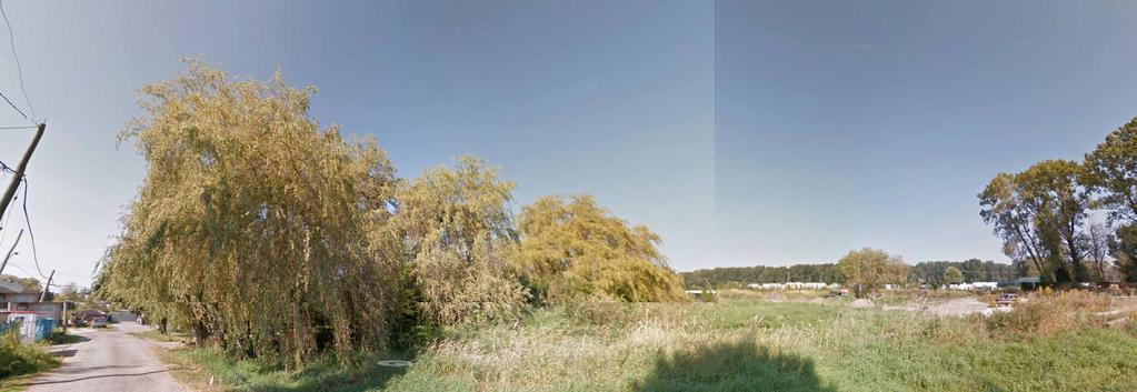
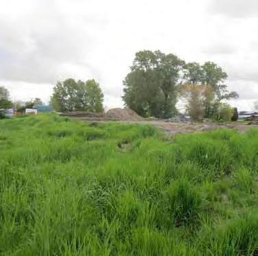
5 City of New Westminster August 19, A copy of the open house presentation materials and display boards has been attached (see Appendix 5). PROPOSAL The applicant is proposing to develop a master planned community within the Queensborough Special Study Area. The proposed development will be guided by a master plan, which will be implemented through an OCP amendment, the development of design guidelines, and subsequent rezoning. The applicant has provided the following vision statement in their proposal about the proposed master planned community: The Queensborough Eastern Neighbourhood Node will become the heart of eastern Queensborough. Through a sensitive mix of viable commercial and residential uses, the node will provide a place where residents of eastern Queensborough can fulfill their daily needs, while providing places to congregate and meet. It will offer employment opportunities in the commercial core, while providing housing to meet the needs of the growing community. The neighbourhood will be connected to its surroundings and the commercial heart with a series of pedestrian oriented streets, multi-use paths and the feature Stanley Street Greenway. It will be environmentally, socially, and economically important to the eastern portion of Queensborough. The applicant s OCP Amendment Applicant Submission Materials have been attached to this report (see Appendix 4). SITE CONTEXT The Special Study Area is bound by Ewen Avenue, Stanley Street, Duncan Street and Furness Street, as defined during the Queensborough Community Plan process. Including the private land not owned by Platform Properties, the Special Study Area is approximately 6.8 hectares (16.8 acres). The Platform Properties lands are used for the City s animal shelter, tow yard, dog park, and storage or are vacant. These uses must be relocated before the land is redeveloped. The remainder of the land in the Special Study Area has a mix of uses including single detached dwellings, light industrial and commercial. There are also a number of vacant properties.
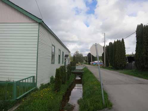
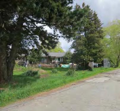
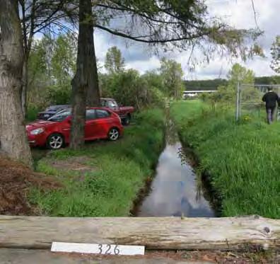
6 City of New Westminster August 19, The Beach Street right-of-way and the Stanley Street right-of-way north of Beach Street are not developed as streets. Both are vegetated and have a watercourse (ditch) with ecological value. Stanley Street is identified in the Queensborough Community Plan as a significant greenway. The remainder of the streets are developed and have open ditches. The Special Study Area is also bound by two rail lines, one running along the north side of Ewen Avenue and the other along the north side of Duncan Street. To the north of the Special Study Area, across Duncan Street, are industrial uses. One of the industrial properties is owned by Port Metro Vancouver and is expected to stay industrial over the long term. An application has been submitted to convert the adjacent industrial land to medium-density residential. The Port Royal residential development is also adjacent to the eastern and southern boundaries of the Special Study Area. The housing that is closest to the Special Study Area consists of compact lot single-detached dwellings. The remainder of the adjacent land uses on the south boundary, across Ewen Avenue, are industrial. These operational industrial properties, including Griff Lumber, are also designated Queensborough Comprehensive Development and would go through a similar master plan process if they were to redevelop. To the west of the Special Study Area, on the other side of the Stanley Greenway, there is a mix of uses. Single detached dwellings and a daycare front onto Ewen Avenue. The remainder of the properties have light industrial uses, single detached dwellings or are vacant. There is currently an application to construct townhouses on the northernmost portion of these properties. POLICY CONTEXT Official Community Plan (OCP) Considerations During the update of the Queensborough Community Plan, the planning and consultation process identified areas of further research, including the Special Study Area. After detailed review, including public consultation, land use designations were endorsed by Council and incorporated into the Queensborough Community Plan. The following are the land use designations in the area: 1. Commercial Main Street: The area bounded by Ewen Avenue, Furness Street, Duncan Street and Mercer Street is designated Commercial Main Street. The existing pub and commercial development under construction in Port Royal also form part of this node. The Commercial Main Street designation allows commercial at grade and residential, commercial and/or office above. This designation would also allow a purely commercial development, such as a grocery store.
7 City of New Westminster August 19, This area is within the Queensborough Main Street Development Permit Area. This development permit area includes design guidelines for form and character that ensure that development in the area creates a main street feel, addresses rail proximity, and strengthens the corner of Furness Street and Ewen Avenue as the main node of the community. 2. Residential Low Density: The area fronting onto Ewen between the pub and Stanley Street is designated Residential Low Density. This designation enables protection of the historic single detached dwellings on these properties. 3. Park or Greenway: The watercourse in the Stanley Street right-of-way is identified as a public greenway and is protected by the Riparian Areas Regulation. This space provides a highly prized open space asset and an important stormwater management function for the community. 4. Queensborough Comprehensive Development: The remaining properties in the Special Study Area are designated Queensborough Comprehensive Development. It is this area that is subject to the Official Community Plan amendment. The Queensborough Community Plan defines this as an area that will include mixed commercial and light industrial employment uses which complement and are compatible with the surrounding existing and designated land uses. The area should also include residential uses which range in densities from low to medium. The maximum floor space ratio should not exceed a factor of 0.9. However, depending on the provision of employment generating uses, additional density for residential uses may be considered. In principle, two-thirds of the contiguous areas of the designation should be developed for employment generating uses. The remaining one-third could be developed as residential. The land use designation also specifies that prior to any rezoning in the area a master plan, including new land use designations and design guidelines, must be created for the area as a whole. This master plan process, which has been initiated by Platform Properties, will be subject to a public review process and must be in accordance with the following principles that are listed in the Queensborough Comprehensive Development Development Permit Area: 1. Locate land uses such that they establish a sensitive transition between industrial and non-industrial land uses. 2. Include residential land uses in locations that will help to complete the eastern residential neighbourhood. 3. Consider including commercial land uses fronting onto Ewen Avenue where they will help to create a compact, local serving commercial node. 4. Reinforce Ewen Avenue as the community main street.
8 City of New Westminster August 19, Protect heritage resources. 6. Protect and enhance riparian areas. 7. Include trail segments shown on the Parks, Trails and Greenway Streets Map (e.g. Stanley Greenway and Mid-Island Trail). 8. Provide an appropriate level of vehicular access in support of community and site-connectivity. The new land use designations and design guidelines will be amended into the Queensborough Community Plan, which is a schedule to the OCP. The specifics of the OCP land use designations and the content of Queensborough Comprehensive Development Development Permit Area are attached (see Appendix 3). Zoning All of the properties in the Special Study Area are zoned Light Industrial Districts (M-1). As a result, Platform Properties will also be submitting a rezoning application to bring each property into conformity with the land use designations determined through the master plan process and subsequent OCP amendment. It is anticipated that the future rezoning application will run concurrently with the OCP amendment process once suitable land uses have been determined for the Special Study Area as part of the master planning process. Other land owners in the area may also choose to apply for a rezoning once the master plan process is complete. DISCUSSION Within the Special Study Area, the properties bound by Stanley Street, Duncan Street, Mercer Street, and the lane north of Ewen Avenue are designated Queensborough Comprehensive Development. The purpose of this designation, and the associated development permit area, is to require a master plan process that would explore appropriate land uses and design guidelines at a greater level of detail than what is typical for a community plan. This approach was seen to be appropriate given the complexities in this area, including the proximity of rail lines and the adjacency of both residential and industrial development. The Queensborough Comprehensive Development designation is also intended to facilitate the development of a mix of employment generating uses and residential uses. The type of employment generating uses required was not specified in the Queensborough Community Plan. It was expected that the viability of different uses would be explored through the master planning process and discussed with City staff and
9 City of New Westminster August 19, the community at that time. The land use designation specifies that a minimum of two thirds of the Queensborough Comprehensive Development area should be used for employment. The preliminary land use concept proposed by Platform Properties is to have only ground-oriented residential uses within the Queensborough Comprehensive Development Area with no employment generating uses. Locating residential uses within this area is believed be in alignment to the views of the community, as expressed by stakeholders during the Queensborough Community Plan process. The appropriate mix and type of land uses will be further explored as the master plan process unfolds. The Queensborough Comprehensive Development Development Permit Area includes principles (listed above) that will help guide the process. The product created at the end of the master plan process will need to outline how each of the principles has been addressed. For example, it should be demonstrated what design guidelines effectively create a sensitive transition between land uses. One of the anticipated challenges with the applicant s initial design concept is that the proposal entails having residential uses along Duncan Street. This concept would further warrant the need to design an effective transition between industrial and residential uses along Duncan Street. Since Platform Properties will also own a significant portion of the property designated Queensborough Main Street (bound by Mercer Street, Duncan Street, Furness Street and Ewen Avenue), this area will also be included as part of the master plan process. It is not anticipated that the land use designation for this area will change, since creating a commercial node in this area is an important priority for the community, as identified in the Queensborough Community Plan. However, the design details and the connections between this area and the Queensborough Comprehensive Development will be discussed in greater detail as part of the master plan process. Platform Properties has assembled a project team that has the necessary expertise in design, traffic, environment and engineering. The project team has created a preliminary design concept document (see Appendix 4) which outlines a draft vision, principles and a preliminary land use concept. These are still general, since this is only the start of the process. Further refinements and a greater level of detail will be added as the process moves forward. Land Use, Density and Height Considerations The consultation process to date has developed some high level concepts for placement of land uses. The preliminary land use concept for the site includes the following: 1. Residential Low Density (RL) There are no anticipated changes to land use or development form within this portion of the Special Study Area
10 City of New Westminster August 19, Queensborough Main Street (MS) As per the vision of the Queensborough Community Plan, this area is intended to develop into a retail node for eastern Queensborough with the provision for mixed residential development. Platform Properties preliminary concept envisions that this area will provide for primarily local-serving retail. The preliminary concept indicates that the anticipated range of retail, commercial, service, and potentially office uses will work towards achieving the overall objectives of the Queensborough Community Plan. The built-form is envisioned as a low-scale, plaza-like environment that provides a gathering place and a community node for residents of east Queensborough. This preliminary concept does not foresee buildings exceeding three to four storeys. This will be further refined through the master plan process based on community input. 3. Queensborough Comprehensive Development (QCD) As per the preliminary concept, the portion of the site designated Queensborough Comprehensive Development is envisioned by Platform Properties to become a predominantly residential neighbourhood. After consideration of the range of uses and market viability of uses in this precinct, Platform Properties feels that residential uses are appropriate for this portion of the site provided there is careful treatment of the greenway edge to buffer from adjacent industrial development. It is believed that this will capitalize on the opportunity to use the main connector roads (Ewen Avenue and Duncan Street) to create the transition between this residential precinct and the adjacent industrial uses surrounding the Special Study Area. The Queensborough Community Plan envisions these main streets as streets with significant pedestrian and cycle infrastructure which creates the ability to forge an appropriate edge between different uses. Further, Platform Properties feels that the residential density is essential to establish a critical mass to support the proposed commercial uses within the eastern shopping node. At this point, the form of the residential development within this area is envisioned to be low profile and ground-oriented in the form of townhouses or compact lot single-detached dwellings. This preliminary concept does not foresee buildings exceeding three storeys or any buildings in an apartment form. The residential density will be determined through the master planning process but is envisioned to be in keeping with the townhouse densities that already exist within the surrounding area. The preliminary land use concept for the Special Study Area will be further refined through the master planning process and community input. A map of the proposed land uses is included in the OCP Amendment Applicant Submission Materials provided by the applicant (see Appendix 4).
11 City of New Westminster August 19, Design Due to the scale of the proposed development and its context within the Queensborough neighbourhood, a new Development Permit Area will be developed for the area currently designated Queensborough Comprehensive Development. These Design Guidelines should reinforce the principles developed for the master plan and should make use of the following Development Permit Area categories in the Local Government Act: protection of the natural environment, its ecosystems and biological diversity; establishment of objectives for the form and character of commercial, industrial or multi-family residential development; establishment of objectives to promote energy conservation; establishment of objectives to promote water conservation; establishment of objectives to promote the reduction of greenhouse gas emissions. The applicant s submission expresses a strong commitment to quality urban design, habitat protection and rehabilitation, sustainable site development, building and landscape practices with a special consideration to include a responsible approach towards stormwater management. Further community consultation should continue to expand on these principles for inclusion within the new Development Permit Area guidelines. Housing The applicant has indicated that the housing forms currently being considered for the Queensborough Comprehensive Development Area are ground-oriented units such as townhouses or compact lot single detached dwellings. The residential uses within the Residential Low Density area will be remain status quo in order to protect heritage properties along Ewen Street. There may be an introduction of residential uses within the Commercial Main Street area as part of a commercial-residential mixed use concept. Tenure will likely consist of strata or freehold ownership, with units that could either be owner-occupied or rental units. Housing considerations will be examined in further detail as the master planning process unfolds. Transportation There are a number of roadways located both within and along the perimeter of the Special Study Area. The Beach Street right-of-way and the Stanley Street right-of-way north of Beach Street are not developed as streets. Both are vegetated and have a watercourse (ditch) with ecological value. Stanley Street is identified in the Queensborough Community Plan as a significant greenway. The remainder of the streets
12 City of New Westminster August 19, are developed and have open ditches. The Study Area is also bound by two rail lines, one running along the north side of Ewen Avenue and the other along the north side of Duncan Street. As part of the master planning process, design standards will be developed for Duncan Street for a greenway street that provides for vehicular travel lanes, a multi-modal pedestrian and bicycle path and landscape treatments within the road right-of-way. Streetscape improvements have recently been completed along Ewen Avenue in order to enhance its role as the main street in Queensborough. The design standards for the Special Study Area will need to outline how to reinforce the greenway feel despite railway lines and to provide a safe pedestrian route on the north side of the tracks. As part of the master planning process, the internal road network within the Special Study Area will be examined in regards to determining suitable lot arrangements and with the goal of creating a rear lane for those properties that front onto Ewen Street and reducing the number of driveways along Ewen Street. The development of a rear lane is being considered since it would minimize the number of vehicular crossings on the railway in order to improve safety. The development of the rear lane will involve further discussion with Special Study Area property owners in order to determine a suitable alignment. The Study Area is within close proximity to transit service. The portions of Duncan Street and Ewen Street that bound the property are located along a bus route (Route 104) which connects to the 22nd Street SkyTrain Station. However, this route has limited service. As part of the master planning process, this proposal will be referred to TransLink so that they are aware of this proposal and how it fits in with the level of public transit service that is currently available for the area. Vehicular access continues to be a concern for the community as expressed by stakeholders during the June 24, 2014 Open house, and previously with the development of the Queensborough Community Plan. The vehicle access issues are primarily due to the fact the Queensborough is geographically constrained by the Fraser River with limited access to the rest of the lower mainland. The applicant has retained the services of a transportation engineer to work on this project. As the master plan process moves forward, further information will be provided in regards to transportation once suitable land uses and densities have been determined for the Special Study Area. Economic Development The Livable City Strategy is the City of New Westminster s economic development strategy. The Livable City Strategy aims to:
13 City of New Westminster August 19, Identify where jobs, investment and non-residential tax revenue will come from in the future; Identify untapped economic development opportunities; Encourage new economic development to help share the cost of improving the community; Increase New Westminster s share of regional employment growth. There is an expectation within the Queensborough Community Plan that the Queensborough Comprehensive Development Area will be primarily used for employment-generating uses. As previously noted, the applicant is proposing groundoriented residential uses (townhouses or compact lot single detached dwellings) within this portion of the Special Study Area. The applicant wishes to explore the possibility of having all non-residential uses located within the Commercial Main Street portion of the Special Study Area. Parks and Green Space There is a public dog park located within the Study Area on one of the parcels that are in the process of being sold to Platform Properties. The City will be relocating the dog park elsewhere within the community. The Parks, Culture, and Recreation Department will be meeting with area residents to identify priorities for a dog park and to assess potential locations. It is anticipated that these discussions will take place in the fall of this year. The Queensborough Community Plan envisions the Stanley Greenway becoming a linear open space that has the opportunity to be environmentally significant because of the existing riparian habitat. When the full length of the Stanley Greenway is completed, it will provide an important connection between the north and south sections of the Queensborough Perimeter Trail. The Stanley Greenway is intended to be developed as a dedicated cyclist and pedestrian route within the Study Area, which is consistent with the policies of the Queensborough Community Plan. The enhancement and design of the Greenway will be further examined as part of the master planning process. Environmental The Stanley Greenway includes a red coded watercourse. There is also a yellow coded watercourse located within the Beach Street road dedication. Platform Properties has retained an environmental consultant to examine all watercourses that are located within the Study Area and to provide further direction on the suggested restoration measures for enhancing the watercourse in the Stanley Greenway. This environmental work will be done in tandem with a drainage study for the area in order to determine the best options
14 City of New Westminster August 19, for stormwater management, protection and enhancement of watercourses within the Special Study Area. Social Impacts and Amenities The design guidelines developed through the master plan and Official Community Plan amendment will incorporate Crime Prevention Through Environmental Design (CPTED) principles in order to provide a stronger sense of personal safety and property security. The uses that will be determined through the master planning process will also be examined in light of surrounding uses to in order to minimize any potential land use conflicts. The Stanley Greenway is also seen as becoming a key outdoor amenity that will be developed in order to improve environmental quality of the local watercourse while creating an important pedestrian connection through the Study Area to trails beyond. Duncan Street will also be developed as a Greenway Street that will provide an important, and safe, pedestrian connection along the upper perimeter of the Study Area. Social impacts and amenities will be examined as the master plan process moves forward and through the subsequent Official Community Plan amendment and rezoning applications. DEVELOPMENT REVIEW PROCESS A preliminary report was provided to Council on the proposed master plan process on June 16, On June 24, 2014, an Open House was held by Platform Properties and the City at the Queensborough Community Centre for stakeholders in the area in order to introduce the master plan process to the community. The next step in the process will be for the City and Platform Properties to meet with Special Study Area property owners in order to ensure their input is considered during the creation of the draft design guidelines and land use concept. Below is an overall outline of the anticipated development review process for this project. The bold text outlines where we are currently at within the process. 1. Preliminary report to Council. 2. Circulation of the application to all City Departments for review. 3. Open house. 4. Advisory Planning Commission and New Westminster Design Panel review of the land use considerations.
15
16 Doc#: Appendix 1: Site Context Map

17 Doc#: Sites Owned by Platform Properties Queensborough Special Study Area Queensborough Comprehensive Development
18 Doc#: Appendix 2: Land Use Designation Map (Existing)

19 Doc#:
20 SCHEDULE C Land Use Designation Map CITY OF BURNABY F r a s e r R i v e r IN CITY OF RICHMOND RM RL RCL A n n H/N HI HI ME CE LI QC HIGHWAY 91A MS RM P RM MS MS MS RM MS SALTER ST RL RCL IN a c i s C RM HOWES ST h a n n e l S RM QC BOYD ST LI RM S RCL WR LI RM HIGHWAY 91A RL LI LI HI LI RL EWEN AVE HI ME HI DERWENT WAY RM POPLAR ISLAND HI ME QCD RM MS RL MS MS RCL QCD RM RM RM RM RH IN KEY: (RL) Residential - Low Density (RCL) Residential - Compact Lot (RM) Residential - Medium Density (RH) Residential - High Density (MS) Queensborough Main Street (QC) Queensborough Commercial (CE) Commercial Entertainment (ME) Mixed Employment (LI) Light Industrial (HI) Heavy Industrial (IN) Intertidal (WR) Waterfront Residential (P) Major Institutional (S) School Parks/Community Facilities (H/N) Habitat/Natural LAND USE DESIGNATIONS MUNICIPALITY OF DELTA ANNACIS ISLAND (DELTA) Utilities (QCD) Queensborough Comprehensive Development QUEENSBOROUGH COMMUNITY PLAN Land Use Designations 138
21 Appendix 3: Text of Official Community Plan Land Use Designation and Development Permit Area
22 Land Use Designations (MS) Queensborough Main Street this area will include commercial, office and residential uses. Facing Ewen Avenue and Furness Street, commercial uses are required at grade. Densities may range from low to medium. (QCD) Queensborough Comprehensive Development This area will include mixed commercial and light industrial employment uses which complement and are compatible with the surrounding existing and designated land uses. This area will also include residential uses which range in densities from low to medium. Depending on the provision of employment generating uses, additional density for residential uses may be considered. In principle, two-thirds of the contiguous areas of the designation will be developed for employment generating uses. The remaining one-third will be developed as residential (the maximum floor space ratio shall not exceed a factor of 0.9). Prior to any rezoning in this area a master plan, including design guidelines, must be created for the area as a whole. This master plan is subject to a public review process and must be in accordance with the principles listed in the Queensborough Comprehensive Development Development Permit Area. (RL) Residential Low Density this area will include low density residential uses including single detached houses, houses with a secondary suite, duplexes, detached townhouses, low density multifamily uses, places of worship, and may contain small scale local commercial uses such as home occupations and corner stores. Development Permit Area #1 Queensborough Comprehensive Development The Queensborough Comprehensive Development Area, identified as Development Permit Area #1 [see Map F], is designated to provide an opportunity to transition between residential and industrial development by allowing light industrial, commercial and residential development. This Development Permit Area encourages best practices for promoting water and energy conservation and reducing greenhouse gas emissions. It also establishes guidelines for the form and character of industrial, commercial and multifamily residential development. Properties located within this Development Permit Area that are zoned Light Industrial Districts (M-1) that develop industrial uses in accordance with the zone must instead comply with the guidelines included in the Queensborough Light Industrial and Mixed Employment Development Permit Area. Properties located within this Development
23 Permit Area that are zoned Heavy Industrial Districts (M-2) that develop industrial uses in accordance with the zone must instead comply with the guidelines included in the Queensborough Heavy Industrial Development Permit Area. In accordance with the Comprehensive Development land use designation, the redevelopment of this area, which includes a rezoning and public review process, will require the creation of a master plan and design guidelines that will be applied to the area. The following principles must be considered in the creation of the master plan: 1. Locate land uses such that they establish a sensitive transition between industrial and non-industrial land uses. 2. Include residential land uses in locations that will help to complete the eastern residential neighbourhood. 3. Consider including commercial land uses fronting onto Ewen Avenue where they will help to create a compact, local serving commercial node. 4. Reinforce Ewen Avenue as the community main street. 5. Protect heritage resources. 6. Protect and enhance riparian areas. 7. Include trail segments shown on the Parks, Trails and Greenway Streets Map (e.g. Stanley Greenway and Mid-Island Trail). 8. Provide an appropriate level
24 Appendix 4: Official Community Plan Amendment Application Package


25 Queensborough Eastern Neighbourhood Node Application for Master Plan Approval and Official Community Plan Amendment On behalf of: BC Ltd. c/o Platform Properties Ltd. June 2014
26 Table of Contents 1! Vision Statement 1! 2! Introduction 2! 3! Site Description 3! 3.1! Location 3! 3.2! Site Characteristics 4! 3.3! Current Land Use Policy and Regulations 4! 3.3.1! Policy History 4! 3.3.2! Current OCP Designation and Zoning 4! 3.3.3! Vision and Community Aspirations 5! 3.3.4! Community Planning Process 6! 4! Project Proposal 7! 4.1! Land Use Allocation 7! 4.2! Greenways and Pedestrian Circulation 8! 4.3! Design Guidelines 9! 5! Application and Consultation Process 10! 5.1! Application Process 10! 5.1.1! City of New Westminster Involvement 10! 5.2! Proposed Consultation Program 10! 6! Summary and Contact Information 12! 6.1! Closure 12! 6.2! Project Contacts 12! 7! Appendices 13! 1
27 1 Vision Statement The Queensborough Eastern Neighbourhood Node will become the heart of eastern Queensborough. Through a sensitive mix of viable commercial and residential uses, the node will provide a place where residents of eastern Queensborough can fulfill their daily needs, while providing places to congregate and meet. It will offer employment opportunities in the commercial core, while providing housing to meet the needs of the growing community. The neighbourhood will be connected to its surrounds and the commercial heart with a series of pedestrian oriented streets, multi-use paths and the feature Stanley Street Greenway. It will be environmentally, socially, and economically important to the eastern portion of Queensborough. 1
28 2 Introduction With the adoption of the Queensborough Community Plan (QCP) in 2014, the City of New Westminster (the City ) established a vision and land-use framework for all of Queensborough. On the strength of that Plan, the Applicant, BC Ltd., as represented by Platform Properties Ltd, began assembling land in the area identified as the east Queensborough Neighbourhood Node and contemplating a mixed-use development that provides employment, housing, and an node for the current and future residents of eastern Queensborough to meet more of their daily retail and service needs in their neighbourhood. This application contemplates two parallel processes. The first is a master planning process as directed in the QCP which will involve the entire plan area shown on Figure 1 in the next section. This will involve land within the control of the Applicant, as well as other privately owned lands. The second process is the OCP amendment process, which under this application will be applied to the lands within the control of the Applicant in Figure 1. Though the City may elect to include other lands, provided there is no implication on the process or the bylaw consideration, the intent of this submission and application is to advance the OCP amendment on the Applicant controlled lands. As the process contemplates additional public consultation over and above that required for an OCP amendment, and specifically the need to prepare a master plan, there are a number of development details that have not yet been resolved. Accordingly, the process will provide many of the details necessary to develop comprehensive design guidelines and land use descriptions. In respect of that process, this submission provides some preliminary development concepts and a general land use framework to initiate the discussion about the more specific development considerations that will emerge through the process. 2

29 3 Site Description 3.1 Location The subject lands are located in the eastern portion of Queensborough. Specifically, the Plan Area for the Master Plan is located north of Ewen Avenue, and bordered by the Stanley Street right of way to the west, Duncan Street to the north, and Furness Street to the east. Though the Master Plan process will include the lands mentioned above, at this time, the OCP amendment will apply only to the lands under the ownership or control of the Applicant in Appendix 2 and identified in Figure 1: In total, the lands controlled by the Applicant and under application for OCP amendment total 3.92 ha (9.68 ac). The entire area of the master plan area is approximately 8.53 ha (21.08 ac). Additionally, the plan area and potential development lands include the public roads and laneways, and it is anticipated the OCP amendment will also include these public rights-of-way. Figure 1: Plan Area and OCP Amendment Application 3
30 3.2 Site Characteristics The lands within the plan area currently contain a mix of uses from residential development, including some heritage residential along Ewen Avenue, as well as commercial development at the eastern edge of the plan area. The lands proposed for OCP amendment are predominantly flat and undeveloped. Existing development on the land consists of the City of New Westminster municipal tow lot fronting on Ewen Avenue, as a public dog-park located at the intersection of Mercer, Duncan and Blackley Streets. The land also contains two significant open drainage ditches, one running within the Stanley Street right-of-way, and the other transecting the site between Mercer Street and Stanley Street, generally within the undeveloped Beach Street right of way. Each of these ditches has been identified as potentially sensitive under the City s Riparian Area Regulations framework. 3.3 Current Land Use Policy and Regulations Policy History In 2014 the City of New Westminster adopted the QCP to guide the future development of all of Queensborough. The QCP was the result of an extensive public consultation program over several years. That document now provides a comprehensive vision and an initial framework for achieving what is important to the community Current OCP Designation and Zoning The lands within the plan area are designated (RL) Residential Low Density on the western portion along Ewen Avenue; (QCD) Queensborough Comprehensive District on the northern portion of the site; and Main Street on the eastern on the portion of the property. The RL designation reflects the historic residential uses along that portion of Ewen Avenue. The QCD is envisioned as mixed-use development with low to medium residential density and commercial and employment generating uses. The Queensborough Main Street designation is intended for commercial and office uses, and includes provision for mixed residential. 4

31 Figure 2: Land Use Designations Vision and Community Aspirations The land uses described above are intended to implement the community visions and aspirations for the area. Most notably, the Community Aspirations Diagram in the Plan identifies the potential for local servicing shopping in the MS designated portion of the area included in the development application. It also identifies the heritage assets in the portion designated RL within the plan area of this application. And finally, it recognizes the importance of the Stanley Street Greenway and the notion of a north-south greenway connection at the western portion of the plan area. In concert, these aspirations create a vision of a community node for eastern Queensborough along Ewen Avenue east of Mercer Street to complement the emerging needs of the swiftly growing community of east Queensborough. This area is referred to as the Eastern Neighbourhood Node in the QCP s Vision Statement. 5
32 3.3.4 Community Planning Process The QCP also specifies some additional parameters for the QCD designation that inform the planning process, and specifically the need for a master planning process. Specifically, the plan states: Queensborough Comprehensive Development Land Use and Designation This area will include a mix of residential and mixed employment land uses. The development of this area would require the parcels to be consolidated and for a master plan to be created. The master plan must adhere to criteria (e.g. requiring a certain amount of employment generating uses in the land use mix) and design guidelines (e.g. creating sensitive transitions between uses). Within the context of these requirements, a developer would have the flexibility to let the market determine what employment generating uses are most viable and to determine the location of the mix of uses. Accordingly, this application is intended to initiate the larger master planning process, which will invariably result in refinements about the mix of land uses, densities, design guidelines and other details over the course of the process and before OCP amendment. 6
33 4 Project Proposal This submission is intended to serve two purposes. The first is to undertake the master planning process called for in the QCP for the Plan Area. The second is to initiate an OCP amendment for the lands controlled by the Applicant identified earlier in Figure 1. As mentioned, the Master Plan will inform many of the details of the final project proposal; however at this stage, the Applicant has developed a concept to initiate the conversation around the master planning process and ultimate OCP amendment. Much of the proposed land use approach and preliminary concept is described in Appendix 1 entitled Queensborough Eastern Neighbourhood: Preliminary Concept. 4.1 Land Use Allocation In brief, the proposed land use allocation described in Appendix 1 follows the general land-use allocation in the QCD, in that little change is contemplated to the RL and MS precincts, and the application is primarily to provide detail and amend the definition of the QCD designation.. Three main land uses within the master plan area are contemplated as part of this initial submission, two of which will be located on the lands under control of the Applicant. 1. The Residential Low Density Precinct The portion designated (RL) Residential Low Density along Ewen Avenue will remain as such and a change in land use or development form is not anticipated. The intent would be to retain and celebrate some of the historic attributes of the area. 2. The Queensborough Main Street Commercial Core The portion designated (MS) Queensborough Main Street will follow almost exactly the vision established in the plan. The area will become the primary commercial retail node for eastern Queensborough, providing local shopping as well as employment. It will also include provision for mixed residential development within that precinct. The commercial development is envisioned as a plaza-like environment, due largely to the edge condition along Ewen Avenue resulting from the active rail-line. This represents an opportunity to provide a meeting place and community node for residents of east Queensborough. The form will likely by low-scale for both commercial and residential uses, with the uses likely mixing on the horizontal plane. Should vertically mixed-uses be included, they will likely still be low-scale and not exceed three or four storeys. Again, these details will be the subject of the public consultation process. 7
34 In addition to the role the MS precinct will play in the community, it is also an opportunity to include land uses and development that generate employment. The anticipated range of retail, commercial, service, and potentially office uses will work towards achieving the overall employment objectives of the QCP. 3. The Queensborough Comprehensive Development District Residential Neighbourhood The portion designated (QCD) Queensborough Comprehensive District is envisioned as a predominantly residential neighbourhood. After considering the range of uses and market viability of uses in this precinct, a sensitive residential treatment of the industrial and greenway edges will provide an appropriate land use arrangement. This will capitalize on the opportunity to use the main connector roads at Ewen Avenue and Duncan Street to mark the transition between this precinct and adjacent industrial uses. These main streets are envisioned as streets with significant pedestrian and cycle infrastructure and this creates the ability to forge an appropriate edge between different uses. Further, the residential density is essential to establish a critical mass to support the proposed commercial and employment generating uses. The residential development will likely be relatively low profile and ground-oriented. Townhouse forms and small lot residential will likely predominate, and within this precinct, the prevailing concept does not have buildings exceeding three-storeys, or any buildings in an apartment form. Townhouse densities comparable to what already exists in the area would be anticipated, with the more precise densities determined through the community planning process. 4.2 Greenways and Pedestrian Circulation The preliminary concept outlined in Appendix 1 also includes a series of greenways and pedestrian-friendly streets to build on and complement the existing pedestrian and cycle infrastructure in the area, particularly along portions of the water s edge and the mixed-use pathways and greenway street on Ewen Avenue and the existing portion of the Stanley Street Greenway south of Ewen Avenue. Specifically, the protection and development of the Stanley Street Greenway adjacent to the proposed development, and pedestrian and cycle improvements on Duncan Street are considered important means of conveying people through eastern Queensborough. As outlined in Appendix 1, the initial concept also contemplates pedestrian sensitive streets within the plan area to build upon the existing and proposed pedestrian and cycle network. 8
35 4.3 Design Guidelines At this stage, it is premature to suggest any design characteristics or elements. Those will emerge through the community planning process; however it is acknowledged that they will form an important component of the OCP amending application in due course. 9
36 5 Application and Consultation Process 5.1 Application Process As directed in the QCP, the intent of this application is to initiate a master planning process for the entire plan area detailed on Figure 1. That master plan framework will help resolve some of the land use issues unresolved in the QCP, and add an additional level of detail with respect to land use specifics, densities, and design guidelines. The Master Plan will inform future development applications by other owners within the plan area. The application is also to amend the OCP as it pertains to the lands identified in Figure 1 as under the control of the Applicant. The precise nature of these OCP amendments will emerge throughout the process, but are intended to facilitate the land use described previously, with additional policies and guidelines to guide future development within the proposed land-use framework City of New Westminster Involvement As the master planning process will affect private lands outside the control of the Applicant, the City has recommended a collaborative planning process driven by the Applicant, but with City resources to provide continuity from the QCP process, and to assist with land-use discussions on other lands. 5.2 Proposed Consultation Program The master planning process will be necessarily consultative in nature. The intent is to engage the community on the proposed land use framework and then seek public input on specific directions on details of the master plan process, such as design guidelines, visual preferences, and specific feedback on the green space and public space elements and designs. Even the name of the community is a topic that will be explored in consultation. To achieve an appropriately robust consultation program, in addition to that statutorily required by the OCP amendment process, the following main consultation steps are being considered in addition to the ongoing dialogue with neighbours and community stakeholders: 1. Initial Awareness (Underway): The intent of this first stage is to meet with community stakeholders and the City to make them aware of the development 10
37 concept and the proposed process. To date feedback has been positively received with respect to process and initial development concept. 2. First Open House (June): The first open house will serve two purposes. It will provide an opportunity for the community to learn about the development concept, but will also provide the initial forum for the community to provide input into shaping the concept and the master plan. 3. Second Open House (September): The second open house will be an opportunity for the Applicant to report out on the findings of the first phase, and then to identify and solicit feedback on any additional or outstanding questions or comments. These main consultation elements are the frame for the consultation program, which will be ongoing and responsive to the community process. These milestones are also in addition to the City s process, which includes engagement with their Advisory Planning and Design Review Committees, and statutory engagement including a formal public hearing. 11
38 6 Summary and Contact Information 6.1 Closure The Applicant is excited at the prospect of working with the City of New Westminster and the Queensborough community to deliver an important community node in accordance with the QCP objective of creating a complete community in eastern Queensborough. Over the course of the process, the Applicant is committed to working through the details important to the community to inform the future development of the lands they control, and to help establish a master planned framework for other lands within the plan area. 6.2 Project Contacts Application Contact: Cameron Chalmers, RPP, MCIP Planning and Development Platform Properties cameron@cameronchalmers.com 12
39 7 Appendices Appendix 1: Queensborough Eastern Neighbourhood: Preliminary Design Concept Appendix 2: Property Descriptions 13
40 QUEENSBOROUGH EASTERN NEIGHBOURHOOD PRELIMINARY CONCEPT Existing site Queensborough, BC Platform Queensborough, BC May 2014


41 1.0 Context Queensborough is undergoing dramatic change including the area surrounding this development site with potential residential, industrial and mixed use development. The Stanley Street Greenway runs along the western edge of the site. The southern edge is defined by Ewen Avenue and a railway. The properties along the north edge of the site on Duncan Street have designated heavy industrial and medium density housing land uses. QUEENSBOROUGH BRIDGE CONNECTION TO THE MAINLAND POPLAR ISLAND DOWNTOWN NEW WESTMINSTER 2.0 Vision The vision for this mixed use site includes developing open space and built form that complements the existing and future neighbourhood, creating a new place in Queensborough that is distinct and recognizable. A network of streets, greenways, green spaces, and pedestrian and cycling pathways to provide links within the development and connections to the rest of Queensborough is an important aspect of the overall vision. PARCEL UNDER REZONING EASTERN NEIGHBOURHOOD CORE PORT ROYAL FUTURE CONNECTION TO DOWNTOWN HIGHWAY 91A TO RICHMOND TO THE HISTORIC HEART CONNECTION TO ANNACIS ISLAND N QUEENSBOROUGH EASTERN NEIGHBOURHOOD 2


 to the")
42 3.0 Urban Design Principles Connections and Circulation Integrate new movement systems into the surrounding vehicular, pedestrian and cycling networks. Edge Conditions Create positive interfaces with existing and future edge developments and conditions including the Stanley Street Greenway, adjacent industrial use, streets and railway. Identity and Character Develop an identity for this new development that reflects the existing rural and industrial character of Queensborough that is compatible with the Port Royal neighbourhood. Neighbourhood Amenities Integrate the Stanley Street Greenway, new public green spaces and a commercial/mixed use node around Mercer Street in the overall site design. These amenities should benefit the local and neighbouring community. Sustainable Design Integrate visible and practical stormwater management systems into the overall site design supported by a balance between hard and soft landscaping. Support sustainable design objectives through compact building forms and a mix of uses and densities that optimize open space and walkability. Safe Community Design Orient front doors (eyes) to the street to support safety and walkability. Ensure lanes, parking and service areas are designed with safety as a priority and traffic calming is incorporated into the street design. QUEENSBOROUGH EASTERN NEIGHBOURHOOD 3

43 4.0 Site Analysis Opportunities POTENTIAL VIEWS TO POPLAR ISLAND * A rich local history and character. * Distant views including Poplar Island. * Green buffers and landscaped edges. * Potential connection to transit network. POPLAR ISLAND FUTURE CONNECTION TO DOWNTOWN * Existing stormwater management strategies ditches and swales. FRASER RIVER * Open space and environmental diversity including the greenways, trails, ditches, swales. * Proximity to the river via existing greenways and trails. * Connections to bikeways and trails including the Stanley Street Greenway and a future pedestrian bridge to downtown New Westminster. * Flexible site design allowing for future consolidation. * Neighbourhood retail and services. Constraints INDUSTRIAL INDUSTRIAL D U N C A N S T FUTURE RESIDENTIAL RESIDENTIAL community garden A mix of adjacent land uses. Limited public transit. Non-contiguous development parcels including grading challenges between new development designed to meet Flood Control Levels (FCL) and existing properties below the FCL. RESIDENTIAL BLACKLEY ST MERCER ST EXISTING PUB EXISTING DOG PARK train track perimeter trail future perimeter trail PORT ROYAL RESIDENTIAL mid-island trail future mid-island trail ditches/swales future greenway street Stanley Street Greenway E W E N A V E PLANNED STANLEY STREET GREENWAY QUEENSBOROUGH COMPREHENSIVE DEVELOPMENT FRASER RIVER future Stanley Street Greenway INDUSTRIAL park masterplan boundary N QUEENSBOROUGH EASTERN NEIGHBOURHOOD 4
44 4.0 Preliminary Concept Diagram: Land Use and Circulation This development site is bounded by Duncan Street, Ewen Avenue and Stanley Street (Greenway). Mercer Street connects Duncan Street and Even Avenue. Blackley Street connects Stanley and Duncan Streets. The rhythm of the existing street network will be retained, and potential new streets, pedestrian pathways and cycling routes will be proposed to provide internal connections and reinforce existing links with the surrounding neighbourhood. Commercial with potential residential mixed use development is envisioned east of Mercer Street. A mix of residential uses is proposed west of Mercer Street. Public open spaces will be located to support the mixed use and residential developments and provide neighbourhood amenity spaces. The overall vision includes developing this new neighbourhood with a mix of uses and public spaces that fits into Queensborough with a distinct character and identity. low density residential (retained) residential commercial with potential residential mixed use site boundary Blackley Street spine Mercer Street spine potential neighbourhood street/mews/lane QUEENSBOROUGH EASTERN NEIGHBOURHOOD 5
45 Appendix 5: June 24, 2014 Open House Presentation Materials and Display Panels
46 An Introduction to the Queensborough Community Plan and the Study Area Rupinder Basi and Lynn Roxburgh Development Services

47 QUEENSBOROUGH STUDY AREA Special Study Area Context

48 QUEENSBOROUGH STUDY AREA Land Use Designation Map

49 QUEENSBOROUGH STUDY AREA What Does the Plan Say?


50 Why a Master Plan? The purpose of the Master Plan is to: Build upon the work undertaken during the development of the Queensborough Community Plan by further exploring appropriate land uses and design guidelines for the Study Area in greater detail. Facilitate the development of properties owned by Platform Properties Inform future development applications by other property owners within the Special Study Area. QUEENSBOROUGH STUDY AREA


51 Planning Principles The following principles must be considered in the creation of the master plan: 1. Locate land uses such that they establish a sensitive transition between industrial and non-industrial land uses. 2. Include residential land uses in locations that will help to complete the eastern residential neighbourhood. 3. Consider including commercial land uses fronting onto Ewen Avenue where they will help to create a compact, local serving commercial node. 4. Reinforce Ewen Avenue as the community main street. QUEENSBOROUGH STUDY AREA


.")

52 Planning Principles The following principles must be considered in the creation of the master plan: 5. Protect heritage resources. 6. Protect and enhance riparian areas. 7. Include trail segments shown on the Parks, Trails and Greenway Streets Map (e.g. Stanley Greenway and Mid-Island Trail). 8. Provide an appropriate level of vehicular access in support of community and siteconnectivity. QUEENSBOROUGH STUDY AREA
53 Process 1. Platform Properties submits an Official Community Plan Amendment Application to launch the Master Plan Process. (June 2014) 2. Preliminary Report to Council. (June 2014) 3. Public Open House (June 2014) (WE ARE HERE) 4. Special Study Area owners meeting. (Summer 2014) 5. Advisory Planning Commission review of the land use considerations. (Summer 2014) 6. Update report to Council. (Fall 2014) 7. Public Open House. (Fall 2014) 8. New Westminster Design Panel review of design guidelines. 9. Report to Council summarizing the master plan process results and formal consultation requirements. (Winter 2015) 10. Report to Council for first and second readings of the OCP amendment bylaw (Spring 2015) 11.Public hearing. (Spring 2015) (Bold Opportunities for Stakeholder Input) QUEENSBOROUGH STUDY AREA

54 Thank You. Questions? Comments. For form information please visit: Rupinder Basi e: t: Lynn Roxburgh e: t:


55 Future Residential SPECIAL STUDY AREA MASTER PLAN OPEN HOUSE STUDY AREA CONTEXT The former School District property, which has been vacant for a number of years, is now owned by Platform Properties. Residential development of the former Star Shipyard will add more residential units adjacent to the north edge of the Study Area. The industrial uses on the Port Metro Vancouver site can operate 24-hours, seven days a week. They will also generate more truck and train traffic along Duncan Street. Port Metro Industrial Special Study Area Platform Properties Lands Future Residential The Queensborough dog park is located in the Study Area. It is important to keep the dog park in the community, although it doesn t have to stay in this location. The City animal shelter is located in the Study Area. Relocating this service would require construction of a new shelter to modern standards. Queensborough Comprehensive Development Eastern Residential Neighbourhood The final phases of Port Royal will add more residential units to this area. Locating residential or mixed use in the Study Area would help to complete this residential neighbourhood. There is a second Comprehensive Development node south of Ewen Avenue. The redevelopment of these properties will also require a Master Plan process. The City tow yard occupies some of the City parcels. Relocating this service will require identifying a similarsized area of City land elsewhere in New Westminster. June 24, 2014
56 SPECIAL STUDY AREA MASTER PLAN OPEN HOUSE QUEENSBOROUGH COMMUNITY PLAN What is the Queensborough Community Plan? The Queensborough Community Plan (QCP) provides a policy framework for achieving the Queensborough Community Vision. The vision describes how the community wants to develop into the future. It helps to ensure that the growth and development of Queensborough is well-targeted and constructive, based on a common understanding of Queensborough s strategic opportunities. The Vision and Plan were developed over a five year planning process that involved on-going consultation with area residents, property owners, business owners, and other stakeholders. Highlights of the Queensborough Community Plan are: Creates an understanding of the community as it is today and projects the future population of the community. Establishes a starting point from which to build on toward achieving the community vision. Establishes Development Permit Areas and design guidelines which provide a clear direction for the form and character of future development. Incorporates specific policies and City actions towards achieving the community vision. Provides land use designations and a map to guide the future development of Queensborough. Land Use Designation Map IN CITY OF RICHMOND RCL RM RL H/N HI HI ME CE LI QC HIGHWAY 91A RM P RM MS MS SALTER ST RM RL RCL IN MS RM MS HOWES ST MS S RM QC BOYD ST LI RM S RCL LI HIGHWAY 91A LI LI HI HI LI RL EWEN AVE RL ME RM HI DERWENT WAY RM HI ME QCD RM MS RL MS MS RCL QCD RM RM RM RM RH IN WR MUNICIPALITY OF DELTA ANNACIS ISLAND (DELTA) (RL) Residential - Low Density (CE) Commercial Entertainment (P) Major Institutional Study Area (RCL) Residential - Compact Lot (ME) Mixed Employment (S) School (RM) Residential - Medium Density (LI) Light Industrial Parks/Community Facilities (RH) Residential - High Density (HI) Heavy Industrial (H/N) Habitat/Natural (MS) Queensborough Main Street (IN) Intertidal Utilities (QC) Queensborough Commercial (WR) Waterfront Residential (QCD) Queensborough Comprehensive Development June 24, 2014
57 SPECIAL STUDY AREA MASTER PLAN OPEN HOUSE QUEENSBOROUGH SPECIAL STUDY AREA Why does this area need a Master Plan? The Study Area includes four land use designations (shown below). One of these land use designations, Queensborough Comprehensive District, requires that a master plan and design guidelines must be created for the whole area prior to any rezoning consideration. This is because the Study Area has complex conditions within a relatively small neighbourhood. These conditions include environmental and historic assets, a broad range of surrounding land uses, and adjacent truck and train routes. Determining land uses for this area requires more detailed analysis than generally conducted for a community plan review. The master plan must be consistent with the site planning principles included in the Queensborough Plan. Once implemented, the master plan will facilitate the development of lands owned by Platform Properties in addition to informing future development applications by other property owners within the Study Area. Role of the City The role of the City in the master planning process will be to work in close collaboration with Platform Properties on the master plan process. City staff and Platform Properties will engage owners in the area in order to ensure that they are involved throughout the master planning process. The City will also be involved in the relocation of the existing dog park, animal shelter, and tow yard that are currently located on the City-owned properties which Platform Properties is purchasing. Role of Other Study Area Property Owners The private property in the Study Area not owned by Platform Properties will also be included in the master plan process. The City and Platform Properties will work directly with property owners who will also be invited to all of the public engagement activities in order to ensure they have meaningful involvement in the master planning process. Park or Greenway: The watercourse in the Stanley Street right-of-way is identified as a public greenway and is protected by the Riparian Areas Regulation. This corridor provides a highly prized open space asset and an important stormwater management function for the community. Queensborough Comprehensive Development: The intent of this designation is to include residential and employment uses which complement and are compatible with the surrounding existing and designated land uses. DUNCAN ST LEGEND Comprehensive Development Zone BEACH ST MERCER ST BLACKLEY ST ROW DUNCAN ST FURNESS ST Residential - Low Density Commercial Main Street Park or Greenway Watercourse Modified Street/Lane STANLEY ST BLACKLEY ST new lane EWEN AVE New Street/Lane DERWENT WAY Platform Properties Lands Railway Line New Street Right of Way STANLEY Residential Low Density: The area fronting onto Ewen Avenue between the pub and Stanley Street is designated Residential Low Density. This designation enables protection of the historic single detached dwellings on these properties. Commercial Main Street: This designation allows commercial at grade and residential, commercial and/ or office above. This designation also allows a purely commercial development, such as a grocery store. June 24, 2014


58 SPECIAL STUDY AREA MASTER PLAN OPEN HOUSE PLANNING PRINCIPLES The following principles were created to guide the master plan process, to provide the community with additional clarity regarding the future of the area and to ensure that future designation of the land in this area will meet the objectives of the Queensborough Community Plan. 1. Locate land uses such that they establish a sensitive transition between industrial and nonindustrial land uses. Port Metro Vancouver owns land north of the Study Area. Industrial uses will occupy the Port s land well into the future. The location of land uses within the Study Area should respond to this. This means land uses that are more compatible with industrial uses should be located close to the Port s land. Land uses that are more compatible with residential uses should be located close to the existing and future residential areas. 2. Include residential land uses in locations that will help to complete the eastern residential neighbourhood. Existing and future residential neighbourhoods are located around the eastern end of the Study Area. Including some residential uses in this part of the Study Area would help make the eastern residential neighbourhood feel complete. 3. Consider including commercial land uses fronting onto Ewen Avenue where they will help to create a compact, local serving commercial node. Residents have long noted the need for locallyserving shops in eastern Queensborough. There are a number of different locations within and next to the Study Area that could be designated as commercial. There are also a number of constraints to developing a main street feel along this part of Ewen Avenue. Integrating shops into this part of Queensborough would require a creative approach to these constraints. 4. Reinforce Ewen Avenue as the community main street. The residential neighbourhoods located around the eastern end of the Study Area feel quite separated from the rest of the Queensborough community. This separation is created by the existing adjacent industrial uses of the Port Metro Vancouver, the Study Area and lands to the south of Ewen Avenue. Revitalizing Ewen Avenue with an updated streetscape would help create a sense of connectivity. June 24, 2014


59 SPECIAL STUDY AREA MASTER PLAN OPEN HOUSE PLANNING PRINCIPLES 5. Protect heritage resources. Protecting and enhancing heritage resources is a high priority for the City. There are a number of single detached houses in the special study area that are more than 50 years old. Managing these heritage resources is made difficult by the surrounding context, including issues related to their small lot size, the flood plain and the adjacent railway. Maintaining these heritage houses would require a creative approach to these constraints. 6. Protect and enhance riparian areas. There are two watercourses in the Study Area identified as protected by the Riparian Areas Regulation. This Provincial policy requires protection measures, including setbacks between the watercourse and constructed areas, and maintenance of planted areas within these setbacks. These local watercourses are key to providing habitat and food sources for fish and other urban wildlife, such as owls. They also provide valuable open space for residents. 7. Include trail segments shown on the Parks, Trails and Greenway Streets Map (e.g. Stanley Greenway and Mid-Island Trail). An interconnected network of trails and greenway streets makes walking and cycling more safe and enjoyable, makes accessing amenities, services and transit easier and helps decrease vehicle use. The Stanley Greenway is a unique Queensborough Amenity that will be a linear open space that has the opportunity to be environmentally significant because of its riparian habitat. 8. Provide an appropriate level of vehicular access in support of community and site-connectivity. Access to the Study Area as well as circulation within the area need careful planning to ensure that the area is livable and that traffic impacts on the surrounding neighbourhood are minimized. Planning for site access also needs to account for the rail lines. As much as possible, the number of crossings should be reduced and those crossings that remain should be designed in a way that achieves whistle cessation. June 24, 2014
60 SPECIAL STUDY AREA MASTER PLAN OPEN HOUSE HOW DID WE GET HERE + NEXT STEPS Launch of the Queensborough Community Plan Review October 2008 Research (October January 2013) - Numerous detailed studies completed on topics such as Employment Lands and Flood Management. Public Consultation (December September 2013) - Land Use Plan, Draft Vision Theme, Goals and Objectives. Launch of the Queensborough Special Study Area Review May 2012 Consultants Retained (September 2012) - Detailed analysis of context, development trends and suitable land uses. Public Open House (October 2012) - Discussion of planning principles and land use. Report to Council (July 2013) - Findings and land use designation recommendations are endorsed by Council and incorporated into the Queensborough Community Plan. Queensborough Community Plan Adoption October 2008 Public Open House (September 2013) - Draft Community Plan. Platform Properties purchase land owned by the School District and begins the process of purchasing land owned by the City. Launch of the Queensborough Special Study Area Master Plan Process June 2014 Platform Properties submits an Official Community Plan Amendment Application to launch the Master Plan Process. (June 2014) Preliminary Report to Council. (June 2014) Public Open House (June 2014) - Visual Preference Survey. Special Study Area owners meeting. (Summer 2014) Advisory Planning Commission review of the land use considerations. (Summer 2014) Update report to Council. (Fall 2014) Public Open House. (Fall 2014) New Westminster Design Panel review of design guidelines We Are Here Report to Council summarizing the master plan process results and formal consultation requirements. (Winter 2015) Adoption of Amended Queensborough Community Plan Spring 2015 Report to Council for first and second readings of the OCP amendment bylaw (Spring 2015) Public hearing. (Spring 2015) For more information please visit June 24, 2014
61 Queensborough Eastern Neighbourhood Node Queensborough Eastern Neighbourhood Node Community Information Meeting July 24, 2014 Cameron Chalmers, MCIP, RPP Platform Properties
62 Queensborough Eastern Neighbourhood Node Meeting Format Purpose Format The purpose of the meeting is to invite the community to learn about the proposed Master Plan process and Official Community Plan amendment application. The meeting is also an opportunity for the community to begin sharing thoughts and ideas for how the neighbourhood will develop over time. 6:00 7:00 Open House Format 7:00 7:20 Presentation by the City of New Westminster and the Applicant 7:20 8:00 Questions and Comment Packages
 and are identified in yellow on the adjacent map. Current Uses Most of the land under application west of Mercer Street is undeveloped.")
63 Queensborough Eastern Neighbourhood Node The Plan Area Description The plan area consists of approximately 8.53 hectares (21 acres) and contains 46 independent lots. The lands under application amount to 3.92 hectares (9.68 acres) and are identified in yellow on the adjacent map. Current Uses Most of the land under application west of Mercer Street is undeveloped. The land under application east of Mercer includes the current dog park, City tow yard, and City animal shelter. The majority of the remaining lands are used primarily for residential use, a pub, and other commercial/light industrial uses.


64 Queensborough Eastern Neighbourhood Node Planning Context and Vision Context The context area has a range of residential, commercial and industrial land uses. Each border of the plan area has a different edge condition. There is an established transportation network that will be enhanced by the new pedestrian bridge to downtown. Vision The vision for this mixed-use site is to complement the existing neighbourhood by adding a new commercial/retail node and compatible residential development with a range of open spaces.


65 Queensborough Eastern Neighbourhood Node Site Analysis Opportunities A rich local history and character Distant views including Poplar Island Green buffers and landscaped edges Potential connection to transit network Open space and environmental diversity Proximity to the river via existing greenways and trails Connections to bikeways and trails Neighbourhood retail and services Constraints A mix of adjacent land uses Limited public transit Non contiguous development parcels Flood Construction Levels (FCL)


66 Queensborough Eastern Neighbourhood Node Proposed Land Use Neighbourhood scale commercial, retail, service, and employment use with potential residential mixed-use development is envisioned east of Mercer Street. A mix of residential uses is proposed west of Mercer Street. Existing low density residential fronting Ewen Avenue will be retained. Public open spaces will be located to support the mixed-use and residential developments and provide neighbourhood amenity spaces.

67 Queensborough Eastern Neighbourhood Node Development Proposal Details Plaza-type commercial development with an emphasis on providing local retail, neighbourhood services, and employment. A neighbourhood node that meets local employment aspirations and creates community gathering places and services to meet daily needs. Mixed-use residential development may also be included in the Main Street precinct, as per the Queensborough Community Plan. The residential precinct will help create critical mass to support the commercial precinct. New residential development will likely be in a townhouse or other ground-oriented form with densities comparable to those in the surrounding neighbourhood. The low-density residential development along Ewen Avenue will be retained.

68 Queensborough Eastern Neighbourhood Node Preliminary Urban Design Principles Balance vehicular, pedestrian and cycling networks. Create positive interfaces with existing and future edge developments. Develop an identity for this new development. Integrate the Stanley Street Greenway, new public green spaces and other amenities that benefit the local and neighbouring community. Integrate visible and practical stormwater management systems and other sustainability initiatives. Orient front doors (eyes) to the street to support safety and walkability.
69 Queensborough Eastern Neighbourhood Node Community Planning Process First Open House Visual Preference Survey Preliminary comments on land use Outcome will be a consultation report Second Open House More detailed land use concepts Comments on design guidelines and detailed development application Outcome will be a detailed development application package Bylaw Consideration Opportunity to make representation to City Council on the detailed design guidelines, land use policies, and development concepts in the OCP amendment and rezoning bylaws Outcome will be an amended OCP and rezoning


70 Queensborough Eastern Neighbourhood Node Visual Preference Survey and Comment Form Please share your thoughts and opinions with us using the Visual Preference Survey and Comment Form. This tool will enable you to comment on land use, neighbourhood character, and preliminary building types. The results of the survey will help guide the detailed policy and design guidelines that will express the vision for this neighbourhood.
71 Queensborough Eastern Neighbourhood Node Thank you! Please feel free to ask questions of any member of our team. Completed comment packages can be submitted at the reception desk or as indicated on the front page.
72 Queensborough Eastern Neighbourhood Node Welcome to the Queensborough Eastern Neighbourhood Node Community Information Meeting Please sign in and take a comment package
73 Queensborough Eastern Neighbourhood Node Meeting Format The purpose of the meeting is to invite the community to learn about the proposed Master Plan process and Official Community Plan amendment application. The meeting is also an opportunity for the community to begin sharing thoughts and ideas for how the neighbourhood will develop over time. 6:00 7:00 Open House Format 7:00 7:20 Presentation by the City of New Westminster and the Applicant 7:20 8:00 Questions and Comment Packages


74 Queensborough Eastern Neighbourhood Node Planning Context and Vision
75 Queensborough Eastern Neighbourhood Node The Plan Area Description The plan area consists of approximately 8.53 hectares (21 acres) and contains 46 independent lots. The lands under application amount to 3.92 hectares (9.68 acres) and are identified in yellow on the adjacent map. The lands are generally flat and within the floodplain, which will require mitigation through either structural fill or elevated building. Current Uses Most of the land under application west of Mercer Street is undeveloped. The land under application east of Mercer includes the current dog park, City tow yard, and City animal shelter. The majority of the remaining lands are used primarily for residential use, a pub, and other commercial/light industrial uses.


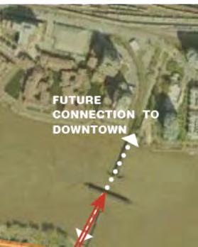
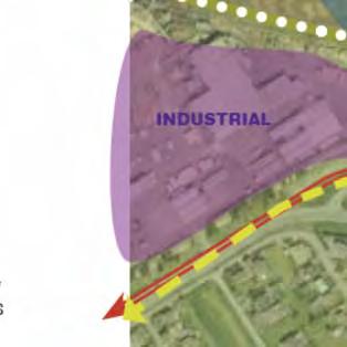
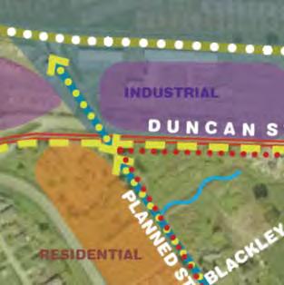
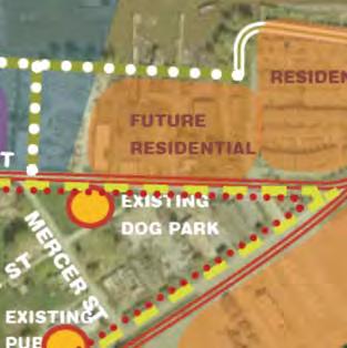
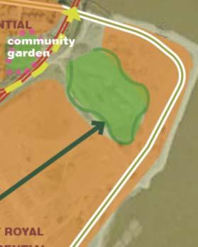
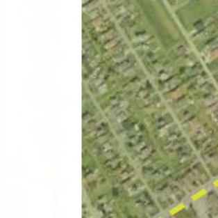
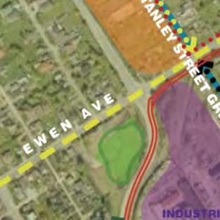
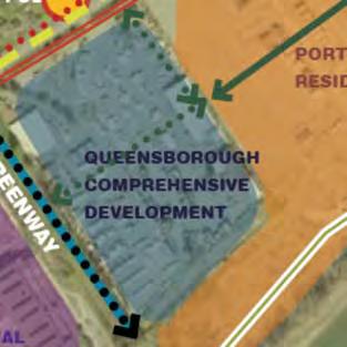
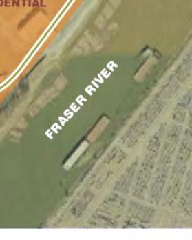
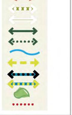
76 Queensborough Eastern Neighbourhood Node Site Analysis

77 Queensborough Eastern Neighbourhood Node Project Proposal

78 Queensborough Eastern Neighbourhood Node Development Proposal Details Main Street Precinct Plaza-type commercial development with an emphasis on providing local retail, neighbourhood services, and employment. The intent is to create a neighbourhood node that meets the local employment aspirations of the community while providing community gathering places and services to meet the daily needs of East Queensborough residents. Mixed-use residential development may also be included in the Main Street precinct, as per the Queensborough Community Plan. Residential Precinct The residential precinct will help create critical mass to support the commercial precinct. The new residential development will likely be in a townhouse or other ground-oriented form with densities comparable to those existing in the neighbourhood. The residential precinct will also respect the low-density and historically important residential development along Ewen Avenue.

79 Queensborough Eastern Neighbourhood Node Preliminary Urban Design Principles

80 Queensborough Eastern Neighbourhood Node Community Planning Process First Open House Visual Preference Survey Preliminary comments on land use Outcome will be a consultation report Second Open House More detailed land use concepts Comments on design guidelines and detailed development application Outcome will be a detailed development application package Bylaw Consideration Opportunity to make representation to City Council on the detailed design guidelines, land use policies, and development concepts in the OCP amendment and rezoning bylaws Outcome will be an amended OCP and rezoning
Queensborough Eastern Neighbourhood Node. Community Open House
 Queensborough Eastern Community Open House The Vision The Queensborough Eastern will become the heart of eastern Queensborough. Through a sensitive mix of viable commercial and residential areas, the neighbourhood
Community Information Meeting
 Queensborough Eastern Community Information Meeting July 24, 2014 Cameron Chalmers, MCIP, RPP Platform Properties Meeting Format Purpose Format The purpose of the meeting is to invite the community to
1071 King Street West Zoning Amendment Application - Preliminary Report
 STAFF REPORT ACTION REQUIRED 1071 King Street West Zoning Amendment Application - Preliminary Report Date: August 9, 2012 To: From: Wards: Reference Number: Toronto and East York Community Council Director,
Regional Context Statement
 5.6 Attachment Regional Context Statement Authority Under the provisions of the Local Government Act (LGA Section 432 and 436), regional districts are granted authority to adopt a Regional Growth Strategy.
Edward R. Sajecki Commissioner of Planning and Building
 Corporate Report Clerk s Files Originator s Files CD.03.POR DATE: TO: FROM: SUBJECT: Chair and Members of Planning and Development Committee Meeting Date: February 27, 2012 Edward R. Sajecki Commissioner
2136 & 2148 Trafalgar Road Town of Oakville Region of Halton
 PLANNING JUSTIFICATION REPORT 2136 & 2148 Trafalgar Road Town of Oakville Region of Halton Zoning By-Law Amendment Application 2500674 Ontario Inc. November 2016 Table of Contents Page 1.0 Location/Summary
Welcome to the Oakridge Centre Open House
 Welcome to the Oakridge Centre Open House Why is the City hosting this event? This open house is to inform you of a rezoning application submitted to the City of Vancouver to amend the existing CD-1 (Comprehensive
KANATA CENTRUM 255 KANATA AVENUE OFFICIAL PLAN AMENDMENT ZONING BY-LAW AMENDMENT
 KANATA CENTRUM 255 KANATA AVENUE OFFICIAL PLAN AMENDMENT ZONING BY-LAW AMENDMENT JUNE 2015 PREPARED BY: FOTENN Consultants Inc. 223 Mcleod Street Ottawa, ON K2P OZ8 (613) 730-5709 PREPARED FOR: Kanata
Gold Line Bus Rapid Transit Transit Oriented Development (BRTOD) Helmo Station Area Plan
 Helmo Station Area Plan") Appendix F Gold Line Bus Rapid Transit Transit Oriented Development (BRTOD) Helmo Station Area Plan Introduction and Purpose of the Plan The Gold Line Bus Rapid Transit facility is an eleven-mile dedicated
Appendix F Gold Line Bus Rapid Transit Transit Oriented Development (BRTOD) Helmo Station Area Plan Introduction and Purpose of the Plan The Gold Line Bus Rapid Transit facility is an eleven-mile dedicated
1-17 Anndale Drive, Bales Avenue and Glendora Avenue Zoning Amendment Application Preliminary Report
 STAFF REPORT ACTION REQUIRED 1-17 Anndale Drive, 31-35 Bales Avenue and 22-70 Glendora Avenue Zoning Amendment Application Preliminary Report Date: August 20, 2007 To: From: Wards: Reference Number: North
CONTENTS 8.0 LAND USE 8.1 GENERAL LAND USE 8.2 RESIDENTIAL 8.3 MIXED USE 8.4 COMMERCIAL 8.5 EMPLOYMENT LANDS
 8-2 Land Use 8.0 LAND USE CONTENTS 8.1 GENERAL LAND USE 8.1.1 Uses provided for in all Land Use Designations 8.1.2 Uses prohibited in Hazardous Lands, Hazardous Sites and Special Policy Areas 8.1.3 Uses
Official Plan Review
 Official Plan Review Summary Report - The Built Environment August 2014 Part 1: Introduction Planning for a healthy, prosperous and sustainable community is an important goal for our municipality. From
Bloor St. W. Rezoning - Preliminary Report
 STAFF REPORT ACTION REQUIRED 1638-1644 Bloor St. W. Rezoning - Preliminary Report Date: April 1, 2008 To: From: Wards: Reference Number: Toronto and East York Community Council Acting Director, Community
URBAN DESIGN BRIEF. 2136&2148 Trafalgar Road. Town of Oakville
 URBAN DESIGN BRIEF 2136&2148 Trafalgar Road Town of Oakville Prepared By: METROPOLITAN CONSULTING INC For 2500674 Ontario Inc November 2016 TABLE OF CONTENTS Page No. 1.0 Introduction/Description of Subject
THAT the attached Terms of Reference for the Thornhill Centre Street Study be approved.
 COMMITTEE OF THE WHOLE AUGUST 18, 2003 THORNHILL CENTRE STREET STUDY PLANNING FILE: 15.92 Recommendation The Commissioner of Planning recommends: THAT the attached Terms of Reference for the Thornhill
Official Plan Review: Draft Built Form Policies
 PG.30.1 REPORT FOR ACTION Official Plan Review: Draft Built Form Policies Date: May 15, 2018 To: Planning and Growth Management Committee From: Chief Planner and Executive Director, City Planning Division
YONGE STEELES CORRIDOR SECONDARY PLAN. Young + Wright / IBI Group Architects Dillon Consulting Ltd. GHK International (Canada) Ltd.
 Ltd.") PART A: PREAMBLE 1.0 PURPOSE The purpose of this Secondary Plan is to provide a development framework for intensification of the Yonge/ Steeles corridor including the north side of Steeles Avenue West
PART A: PREAMBLE 1.0 PURPOSE The purpose of this Secondary Plan is to provide a development framework for intensification of the Yonge/ Steeles corridor including the north side of Steeles Avenue West
1.0 Purpose of a Secondary Plan for the Masonville Transit Village
 Report to Planning and Environment Committee To: Chair and Members Planning & Environment Committee From: John M. Fleming Managing Director, Planning and City Planner Subject: Masonville Transit Village
CITY OF LANGLEY OFFICIAL COMMUNITY PLAN BYLAW, 2005, NO APPENDIX II - REGIONAL CONTEXT MAP
 CITY OF LANGLEY OFFICIAL COMMUNITY PLAN BYLAW, 2005, NO. 2600 APPENDIX II - REGIONAL CONTEXT MAP ± Legend Agricultural Mixed Employment Industrial Conservation & Recreation Regional City Centre Urban Containment
178 Carruthers Properties Inc.
 178 Carruthers Properties Inc. Planning Rationale for 178 Carruthers Avenue Site Plan Control Application June 2014 Table of Contents 1.0 Introduction 2.0 Overview of Subject Property 3.0 Current Zoning
1. POPLAR LANDING + MUNI EVERS PARK
 . POPLAR LANDING + MUNI EVERS PARK WHAT S HAPPENING? PROJECT DESCRIPTION PROJECT TIMELINE Poplar Landing and the future Muni Evers Park site (located at 00 Quayside Drive) is jointly owned by the City
5 TOWN OF MARKHAM OFFICIAL PLAN AMENDMENT NO. 144 MILLIKEN MAIN STREET SECONDARY PLAN
 5 TOWN OF MARKHAM OFFICIAL PLAN AMENDMENT NO. 144 MILLIKEN MAIN STREET SECONDARY PLAN The Planning and Economic Development Committee recommends the following: 1. The communication from Brendan O Callaghan,
ADMINISTRATION RECOMMENDATION(S) 2018 January 25. That Calgary Planning Commission recommend APPROVAL of the proposed Land Use Amendment.
 2018 January 25. That Calgary Planning Commission recommend APPROVAL of the proposed Land Use Amendment.") Page 1 of 9 EXECUTIVE SUMMARY This land use amendment proposes to redesignate a parcel from DC Direct Control District to Multi-Residential Contextual Grade-Oriented (M-CG) District to allow for multi-residential
Page 1 of 9 EXECUTIVE SUMMARY This land use amendment proposes to redesignate a parcel from DC Direct Control District to Multi-Residential Contextual Grade-Oriented (M-CG) District to allow for multi-residential
John M. Fleming Managing Director, Planning and City Planner. Old East Village Dundas Street Corridor Secondary Plan Draft Terms of Reference
 Report to Planning and Environment Committee To: From: Subject: Chair and Members Planning & Environment Committee John M. Fleming Managing Director, Planning and City Planner Old East Village Dundas Street
Land Use Amendment in Southwood (Ward 11) at and Elbow Drive SW, LOC
 at and Elbow Drive SW, LOC") 2018 November 15 Page 1 of 10 EXECUTIVE SUMMARY This land use amendment application was submitted by Rick Balbi Architect on 2017 August 31 on behalf of Sable Developments Ltd, and with authorization from
2018 November 15 Page 1 of 10 EXECUTIVE SUMMARY This land use amendment application was submitted by Rick Balbi Architect on 2017 August 31 on behalf of Sable Developments Ltd, and with authorization from
PORT WHITBY COMMUNITY
 PORT WHITBY COMMUNITY SECONDARY PLAN UPDATE COMMUNITY IMPROVEMENT PLAN URBAN DESIGN GUIDELINES September 2015 DRAFT PROPOSED AMENDMENT NUMBER # to the Whitby Official Plan PURPOSE: The intent of this Amendment
DRAFT Northeast Quadrant of Kipling Avenue and Highway 7 DRAFT AUGUST 29, Goals Land Use. The goals of this Plan are to:
 AUGUST 29, 2017 12.15 Northeast Quadrant of Kipling Avenue and Highway 7 12.15.1 Goals 12.15.2 Land Use The goals of this Plan are to: 12.15.2.1 General Provisions: a) Ensure the development of a compact
Welcome. Walk Around. Talk to Us. Write Down Your Comments
 Welcome This is an information meeting introducing the applications for proposed redevelopment of the Yorkdale Shopping Centre site at 3401 Dufferin Street and 1 Yorkdale Road over the next 20+ years,
Crofton Manor 2803 West 41st Avenue WHAT WE HEARD. Public Consultation: Phase 1
 Crofton Manor 2803 West 41st Avenue WHAT WE HEARD Public Consultation: Phase 1 Background CROFTON MANOR What s Happening The City of Vancouver is undertaking a planning and public engagement process to
POLICY AMENDMENT AND LAND USE AMENDMENT TUXEDO PARK (WARD 9) CENTRE STREET N AND 26 AVENUE NE BYLAWS 36P2017 AND 234D2017
 CENTRE STREET N AND 26 AVENUE NE BYLAWS 36P2017 AND 234D2017") Page 1 of 11 EXECUTIVE SUMMARY This application proposes to redesignate a single parcel of land in the Community of Tuxedo Park from Commercial Corridor 2 (C-COR2 f1h10) District to Mixed Use Active Frontage
Page 1 of 11 EXECUTIVE SUMMARY This application proposes to redesignate a single parcel of land in the Community of Tuxedo Park from Commercial Corridor 2 (C-COR2 f1h10) District to Mixed Use Active Frontage
Figure 1- Site Plan Concept
 Figure 1- Site Plan Concept Parking will be provided underground on three levels at rate of 1.0 space/ unit; this rate includes all visitors parking. MMM Group has prepared a parking assessment (April,
Chapter 1. Community Context. Vision Statement Population and Housing Trends Legislative Context Regional Context Statement
 Chapter 1 Community Context Vision Statement Population and Housing Trends Legislative Context Regional Context Statement 1.1 VISION STATEMENT CORPORATE MISSION STATEMENT To promote a safe and livable
ELMVALE ACRES SHOPPING CENTRE MASTER PLAN
 ELMVALE ACRES SHOPPING CENTRE MASTER PLAN Contents 1.0 INTRODUCTION... 2 2.0 LOCATION... 2 3.0 EXISTING CONTEXT... 2 4.0 VISION & GUIDING PRINCIPLES... 2 5.0 LAND USE AND BUILT FORM... 4 5.1 St. Laurent
Hamilton Area Plan Bylaw 9000 Schedule 2.14
 Official Community Plan (OCP) Hamilton Area Plan Bylaw 9000 Schedule 2.14 Original Adoption: June 19, 1995 Plan Adoption: February 25, 2014 Planning Area Boundaries Map Hamilton Area Plan Boundary Map
FORMER CANADIAN FORCES BASE (CFB) ROCKCLIFFE SECONDARY PLAN. Official Plan Amendment XX to the Official Plan for the City of Ottawa
 ROCKCLIFFE SECONDARY PLAN. Official Plan Amendment XX to the Official Plan for the City of Ottawa") FORMER CANADIAN FORCES BASE (CFB) ROCKCLIFFE SECONDARY PLAN Official Plan Amendment XX to the Official Plan for the City of Ottawa 1 INDEX THE STATEMENT OF COMPONENTS PART A THE PREAMBLE PAGE Purpose...
FORMER CANADIAN FORCES BASE (CFB) ROCKCLIFFE SECONDARY PLAN Official Plan Amendment XX to the Official Plan for the City of Ottawa 1 INDEX THE STATEMENT OF COMPONENTS PART A THE PREAMBLE PAGE Purpose...
4.1.3 LAND USE CATEGORIES
 4.1.3 LAND USE CATEGORIES a. City Center District The City Center District incorporates the existing character and mix of uses in downtown Belmont to encourage redevelopment and new development in keeping
Midtown Greenway Land Use and Development Plan Executive Summary
 Midtown Greenway Land Use and Development Plan Executive Summary Introduction The Midtown Greenway Land Use and Development Plan sets policy direction for land use and development in the Midtown Greenway
Stanley Greene District Downsview (80 Carl Hall Road) Zoning By-law Amendment and Draft Plan of Subdivision Applications Request for Direction Report
 Zoning By-law Amendment and Draft Plan of Subdivision Applications Request for Direction Report") STAFF REPORT ACTION REQUIRED Stanley Greene District Downsview (80 Carl Hall Road) Zoning By-law Amendment and Draft Plan of Subdivision Applications Request for Direction Report Date: December 16, 2011
STAFF REPORT ACTION REQUIRED Stanley Greene District Downsview (80 Carl Hall Road) Zoning By-law Amendment and Draft Plan of Subdivision Applications Request for Direction Report Date: December 16, 2011
REZONING GUIDE. Zone Map Amendment (Rezoning) - Application. Rezoning Application Page 1 of 3. Return completed form to
 - Application. Rezoning Application Page 1 of 3. Return completed form to") Zone Map Amendment (Rezoning) - Application COMMUNITY PLANNING & DEVELOPMENT REZONING GUIDE Rezoning Application Page 1 of 3 PROPERTY OWNER INFORMATION* CHECK IF POINT OF CONTACT FOR APPLICATION Property
Zone Map Amendment (Rezoning) - Application COMMUNITY PLANNING & DEVELOPMENT REZONING GUIDE Rezoning Application Page 1 of 3 PROPERTY OWNER INFORMATION* CHECK IF POINT OF CONTACT FOR APPLICATION Property
Complete Neighbourhood Guidelines Review Tool
 Complete Neighbourhood Guidelines Review Tool Prepared By: City of Regina Planning Department October 2014 Page 1 of 14 Community Development Review Checklist for Secondary Plans and Concept Plans The
SECTION ONE: INTRODUCTION. introduction
 introduction 1 INTRODUCTION Since it was first established in 1843 as a trading post for the Hudson s Bay Company, Victoria has evolved into a Provincial capital city that is recognized across Canada and
A Growing Community Rural Settlement Areas
 Town of Huntsville Official Plan Review - POLICY BACKGROUND PAPER A Growing Community Rural Settlement Areas BACKGROUND: In addition to the fully municipally-serviced Urban Settlement Area and the Hidden
and services The protection and conservation of environmentally significant and sensitive natural heritage features and functions.
 6. Land Use 6.0 Preamble A healthy and livable city is one in which people can enjoy a vibrant economy and a sustainable healthy environment in safe, caring and diverse neighbourhoods. In order to ensure
646 Kingston Road - Official Plan Amendment and Zoning Amendment Applications - Preliminary Report
 STAFF REPORT ACTION REQUIRED 646 Kingston Road - Official Plan Amendment and Zoning Amendment Applications - Preliminary Report Date: December 8, 2014 To: From: Wards: Reference Number: Toronto and East
ARTICLE 6: Special and Planned Development Districts
 ARTICLE 6: Special and Planned Development Districts 6-10 Traditional Neighborhood Development (TND) District 6-10.10 Purpose and Intent The Traditional Neighborhood Development (TND) District provides
The West Vaughan Employment Area Secondary Plan Policies
 Part 2: The West Vaughan Employment Area Secondary Plan Policies 2.1 General Policies It is the policy of Council: 2.1.1. That the West Vaughan Employment Area (the WVEA), identified on Schedule 1, will
Planning and Growth Management Committee. Chief Planner and Executive Director, City Planning Division. Pg12013 (File No NNY 34 OZ)
") 865 York Mills Road Official Plan Amendment Application Preliminary Report STAFF REPORT ACTION REQUIRED Date: February 28, 2012 To: From: Wards: Reference Number: Planning and Growth Management Committee
865 York Mills Road Official Plan Amendment Application Preliminary Report STAFF REPORT ACTION REQUIRED Date: February 28, 2012 To: From: Wards: Reference Number: Planning and Growth Management Committee
PUBLIC OPEN HOUSE HURONTARIO-MAIN CORRIDOR SECONDARY PLAN
 PUBLIC OPEN HOUSE HURONTARIO-MAIN CORRIDOR SECONDARY PLAN Tuesday, February 28, 2012 6pm 9pm 1 st Floor Atrium, City Hall 2 Wellington Street West, Brampton 1 POLICY FRAMEWORK The 2006 Provincial Growth
13 THORNHILL YONGE STREET STUDY IMPLEMENTATION CITY OF VAUGHAN OPA 669 AND TOWN OF MARKHAM OPA 154
 13 THORNHILL YONGE STREET STUDY IMPLEMENTATION CITY OF VAUGHAN OPA 669 AND TOWN OF MARKHAM OPA 154 The Planning and Economic Development Committee recommends the adoption of the recommendations contained
LAND USE AMENDMENT CORNERSTONE (WARD 3) 60 STREET NE AND COUNTRY HILLS BOULEVARD NE MAP 26NE BYLAW 22D2017
 60 STREET NE AND COUNTRY HILLS BOULEVARD NE MAP 26NE BYLAW 22D2017") Page 1 of 14 EXECUTIVE SUMMARY This Land Use Amendment application covers an area of 43.76 hectares ± (108.14 acres ±) located in northeast Calgary, bound by Country Hills Boulevard NE to the south and
Page 1 of 14 EXECUTIVE SUMMARY This Land Use Amendment application covers an area of 43.76 hectares ± (108.14 acres ±) located in northeast Calgary, bound by Country Hills Boulevard NE to the south and
and Richmond Street West - Official Plan Amendment Application - Preliminary Report
 STAFF REPORT ACTION REQUIRED 822-838 and 860-862 Richmond Street West - Official Plan Amendment Application - Preliminary Report Date: August 14, 2017 To: From: Wards: Reference Number: Toronto and East
POLICY AMENDMENT AND LAND USE AMENDMENT KILLARNEY/GLENGARRY (WARD 8) NW CORNER OF RICHMOND ROAD AND 33 STREET SW BYLAWS 1P2015 AND 7D2015
 NW CORNER OF RICHMOND ROAD AND 33 STREET SW BYLAWS 1P2015 AND 7D2015") Page 1 of 13 EXECUTIVE SUMMARY This application seeks to redesignate an RC-2 (Residential Contextual One/Two Dwelling) parcel to MC-Gd72 (Multi-Residential Contextual Grade-Oriented) to allow for multi-residential
Page 1 of 13 EXECUTIVE SUMMARY This application seeks to redesignate an RC-2 (Residential Contextual One/Two Dwelling) parcel to MC-Gd72 (Multi-Residential Contextual Grade-Oriented) to allow for multi-residential
The Corporation of the TOWN OF MILTON
 Report to: From: Chair & Members of the Administration & Planning Standing Committee W.F. Mann, Director of Planning and Development Date: April 16, 2012 PD 022-12 (Z19/11) Subject: Technical Report Proposed
Planning Board Briefing
 Planning Board Briefing Why Now? The Sector Plan Implementation Chapter States: Before Stage 1 begins, the following must occur: Approval of the Sectional Map Amendment. Approval of the Greater Lyttonsville
Regional Context Statement
 Regional Context Statement REGIONAL CONTEXT STATEMENT 3. REGIONAL CONTEXT STATEMENT In 1995, the Provincial Government passed into law the Growth Strategies Act. The purpose of this provincial initiative
[PLANNING RATIONALE] For Site Plan Control and Lifting of Holding Zone By-Law 101 Champagne Avenue. May 23, 2014
![[PLANNING RATIONALE] For Site Plan Control and Lifting of Holding Zone By-Law 101 Champagne Avenue. May 23, 2014](/thumbs/75/71599615.jpg "[PLANNING RATIONALE] For Site Plan Control and Lifting of Holding Zone By-Law 101 Champagne Avenue. May 23, 2014") [PLANNING RATIONALE] For Site Plan Control and Lifting of Holding Zone By-Law 101 Champagne Avenue May 23, 2014 Contents 1.0 Introduction... 2 2.0 Site Context... 2 2.1 Adjacent Uses... 2 Figure 1: Site
[PLANNING RATIONALE] For Site Plan Control and Lifting of Holding Zone By-Law 101 Champagne Avenue May 23, 2014 Contents 1.0 Introduction... 2 2.0 Site Context... 2 2.1 Adjacent Uses... 2 Figure 1: Site
1296 Kennedy Road - Zoning Amendment Application - Preliminary Report
 STAFF REPORT ACTION REQUIRED 1296 Kennedy Road - Zoning Amendment Application - Preliminary Report Date: January 15, 2016 To: From: Wards: Reference Number: Scarborough Community Council Acting Director,
Westwind Developments Ltd. PIONEER LANDS AREA STRUCTURE PLAN - PROPOSED AMENDMENT
 FEBRUARY 2013 TABLE OF CONTENTS 1.0 BACKGROUND... 1 1.1 Amendment... 1 2.0 LOCATION & CONTEXT... 2 2.1 Land Ownership... 2 3.0 POLICY CONTEXT... 3 3.1 Municipal Development Plan... 3 3.2 Capital Region
A. WHAT IS A GENERAL PLAN?
 I. Introduction A. WHAT IS A GENERAL PLAN? A general plan is the planning guideline for the future of a city. It contains goals and policies which regulate urban development, the protection of the natural
3. Endorse the LRT vision in transforming Surrey into Connected-Complete-Livable communities, and more specifically, the official vision statement:
 CORPORATE REPORT NO: R038 COUNCIL DATE: February 20, 2017 REGULAR COUNCIL TO: Mayor & Council DATE: February 16, 2017 FROM: General Manager, Engineering FILE: 8740-01 SUBJECT: Surrey Light Rail Transit
Urban Design Brief. Watson Parkway North & Watson Road North Guelph, Ontario. Prepared by Coletara Development
 Urban Design Brief Watson Parkway North & Watson Road North Guelph, Ontario Prepared by Coletara Development December, 2013 Urban Design Brief, Coletara Development 1 Introduction This Urban Design Brief
New Westminster Downtown Parking Strategy Public Open House #1 September 13, 2012
 New Westminster Downtown Parking Strategy Public Open House #1 September 13, 2012 The City is preparing a strategy for parking in Downtown New Westminster. The study team and a group of key stakeholders
Mark-up of the effect of the proposed Bronte Village Growth Area OPA No.18 on the text of section 24, Bronte Village, of the Livable Oakville Plan
 Mark-up of the effect of the proposed Bronte Village Growth Area OPA No.18 on the text of section 24, Bronte Village, of the Livable Oakville Plan Notes: This document is provided for information purposes
Chapter 1.0 Introduction
 Chapter 1.0 Introduction 1.1 Background The North Metro commuter rail line is part of the RTD FasTracks regional transit system expansion program to build more than 100 miles of rail transit throughout
NEW REGIONAL OFFICIAL PLAN HIGH LEVEL PROCESS & FRAMEWORK
 NEW REGIONAL OFFICIAL PLAN HIGH LEVEL PROCESS & FRAMEWORK Why A New Official Plan Originally the role of Regionally Planning and content of Regional Official Plan (1970s) primarily focused on protecting
Queen Street West - Zoning Amendment Application - Preliminary Report
 STAFF REPORT ACTION REQUIRED 944-952 Queen Street West - Zoning Amendment Application - Preliminary Report Date: February 6, 2013 To: From: Wards: Reference Number: Toronto and East York Community Council
The Corporation of the Town of Milton
 Report To: From: Council Barbara Koopmans, Commissioner, Planning and Development Date: May 7, 2018 Report No: Subject: Making it Possible Positioning the Town s Strategy for Growth and Economic Development
ROAD CLOSURE AND LAND USE AMENDMENT SILVER SPRINGS (WARD 1) NORTHEAST OF NOSEHILL DRIVE NW AND SILVER SPRINGS ROAD NW BYLAWS 2C2018 AND 29D2018
 NORTHEAST OF NOSEHILL DRIVE NW AND SILVER SPRINGS ROAD NW BYLAWS 2C2018 AND 29D2018") Page 1 of 19 EXECUTIVE SUMMARY This application proposes redesignating two parcels in the community of Silver Springs from Special Purpose Future Urban Development (S-FUD) District and undesignated road
Page 1 of 19 EXECUTIVE SUMMARY This application proposes redesignating two parcels in the community of Silver Springs from Special Purpose Future Urban Development (S-FUD) District and undesignated road
AWH REPORT OF THE PLANNING AND DEVELOPMENT DEPARTMENT FOR APPLICATION FOR REZONING ORDINANCE TO PLANNED UNIT DEVELOPMENT
 AWH REPORT OF THE PLANNING AND DEVELOPMENT DEPARTMENT FOR APPLICATION FOR REZONING ORDINANCE TO PLANNED UNIT DEVELOPMENT MAY 8, 2014 The Planning and Development Department hereby forwards to the Planning
4- PA - LD - LIVELY DOWNTOWN. LD - Background
 4- PA - LD - LIVELY DOWNTOWN LD - Background The downtown has been the service centre for the community since the city s inception and the area continues to supply people with their personal services,
URBAN DESIGN BRIEF URBAN DESIGN BRIEF 721 FRANKLIN BLVD, CAMBRIDGE August 2018
 URBAN DESIGN BRIEF URBAN DESIGN BRIEF 721 FRANKLIN BLVD, CAMBRIDGE August 2018 DESIGN BRIEF CONTENTS PART A 1.0 INTRODUCTION 2.0 DESCRIPTION & ANALYSIS OF SITE CONTEXT 3.0 DESIGN CONSTRAINTS AND OPPORTUNITIES
McCowan Precinct Plan Study Background & Deliverables
 1 DRAFT & WITHOUT PREJUDICE McCowan Precinct Plan Study Background & Deliverables In September, 2011, City Planning (Scarborough District) began a study of an area within the Scarborough Centre, identified
The River Hub: NEW BUILDINGS
 Summary The River Hub includes 6 municipalities that all boarder the Fraser River. Combined, they are expected to double in population over the next 50 years. To accommodate this new population, 138,831
South of Eastern Strategic Direction Status Update
 STAFF REPORT ACTION REQUIRED South of Eastern Strategic Direction Status Update Date: July 10, 2014 To: From: Planning and Growth Management Committee Chief Planner and Executive Director, City Planning
Clairtrell Area Context Plan
 Clairtrell Area Context Plan March 2005 Urban Development Services City Planning Contents 1. Introduction... 4 2. Development Structure... 6 2.1 Streets... 7 2.1.1 Sheppard Avenue and Bayview Avenue...
Planning and Public Consultation Process for the Preparation of a General Land Use Plan for South Port Kells TERMS OF REFERENCE
 APPENDIX "B" Planning and Public Consultation Process for the Preparation of a General Land Use Plan for South Port Kells TERMS OF REFERENCE PURPOSE South Port Kells is located in the northeastern quadrant
523, 525 and 525A Adelaide Street West - Zoning Amendment Application - Preliminary Report
 STAFF REPORT ACTION REQUIRED 523, 525 and 525A Adelaide Street West - Zoning Amendment Application - Preliminary Report Date: May 12, 2012 To: From: Wards: Reference Number: Toronto and East York Community
2900 Steeles Avenue East at Don Mills Road in the Town of Markham
 STAFF REPORT INFORMATION ONLY 2900 Steeles Avenue East at Don Mills Road in the Town of Markham Date: January 23, 2008 To: From: Wards: Reference Number: North York Community Council Director, Community
SUBJECT: Waterfront Hotel Planning Study Update TO: Planning and Development Committee FROM: Department of City Building. Recommendation: Purpose:
 Page 1 of Report PB-23-18 SUBJECT: Waterfront Hotel Planning Study Update TO: Planning and Development Committee FROM: Department of City Building Report Number: PB-23-18 Wards Affected: 2 File Numbers:
Appendix C: Interim Mixed-Use Evaluation Criteria
 Appendix C: Interim Mixed-Use Evaluation Criteria C-1 Appendix C: Interim Mixed-Use Evaluation Criteria PURPOSE: The implementation of numerous policies contained within the Master Plan hinges on the creation
MAYFIELD WEST SECONDARY PLAN PHASE 2
 MAYFIELD WEST SECONDARY PLAN PHASE 2 Public Open House #3 February 25, 2010 Draft Preferred Land Use Scenario TOWN OF CALEDON PLANNING & DEVELOPMENT DEPARTMENT Open House Agenda TOWN OF CALEDON 1. Welcome
Trafalgar Road Corridor Planning Study Open House
 Trafalgar Road Corridor Planning Study Open House June 24, 2013 6:30-8:30 p.m. Oakville & Trafalgar Rooms Overview The Livable Oakville Plan identifies the lands along Trafalgar Road, between the QEW and
6 Growth Management Challenges and Opportunities
 6 Growth Management Challenges and Opportunities The Town has established a goal of attaining a 50% participation rate with respect to employment opportunities versus residential population. The Town s
Regency Developments. Urban Design Brief. Holyrood DC2 Rezoning
 Regency Developments Urban Design Brief Holyrood DC2 Rezoning Stantec Consulting Ltd. 7-31-2017 1. Overview Regency Developments intends to rezone the lands located at 8510 and 8511 93 Avenue, within the
Create Policy Options Draft Plan Plan Approval. Public Consultation Events. Phase 2
 Background Grandview-Woodland Community Plan In the spring of 2012, the City of Vancouver embarked on a comprehensive community planning program in the Grandview-Woodland neighbourhood. The process has
S A C R A M E N T O C O U N T Y JACKSON HIGHWAY & GRANT LINE EAST VISIONING STUDY
 JACKSON HIGHWAY & GRANT LINE EAST S A C R A M E N T O C O U N T Y P L A N N I N G D E P A R T M E N T SUMMARY AND WORKBOOK November 19, 2008 History of the Visioning Study Sacramento County has two growth
4780 Eglinton Avenue West - Zoning By-law Amendment and Draft Plan of Subdivision Applications - Preliminary Report
 STAFF REPORT ACTION REQUIRED 4780 Eglinton Avenue West - Zoning By-law Amendment and Draft Plan of Subdivision Applications - Preliminary Report Date: May 29, 2014 To: From: Wards: Reference Number: Etobicoke
150 Eighth Street Zoning By-law Amendment Application Preliminary Report
 REPORT FOR ACTION 150 Eighth Street Zoning By-law Amendment Application Preliminary Report Date: March 27, 2019 To: Etobicoke York Community Council From: Director, Community Planning, Etobicoke York District
8 Oak Street - Official Plan and Zoning By-law Amendment Application - Preliminary Report
 STAFF REPORT ACTION REQUIRED 8 Oak Street - Official Plan and Zoning By-law Amendment Application - Preliminary Report Date: March 17, 2014 To: From: Wards: Reference Number: Planning and Growth Management
Town Center (part of the Comprehensive Plan)
") Town Center (part of the Comprehensive Plan) Mercer Island Town Center Looking North (2014) In 1994, a year-long process culminated in a set of design guidelines and code requirements for the Town Center
Town Center (part of the Comprehensive Plan) Mercer Island Town Center Looking North (2014) In 1994, a year-long process culminated in a set of design guidelines and code requirements for the Town Center
MOUNT PLEASANT SECONDARY PLAN & VILLAGE BLOCK PLAN. Wednesday, March 5, 2008 Informal Public Open House
 MOUNT PLEASANT SECONDARY PLAN & VILLAGE BLOCK PLAN Wednesday, March 5, 2008 Informal Public Open House 1. Welcome & Introductions 2. Highlights of Provincial Growth Plan 3. Overview and Status Update -
20 & 30 Frank Nighbor Place
 Engineering Land / Site Development Municipal Infrastructure Environmental / Water Resources Traffic / Transportation Structural Recreational Planning Land / Site Development Planning Application Management
Long Branch Neighbourhood Character Guidelines Final Report
 STAFF REPORT ACTION REQUIRED Long Branch Neighbourhood Character Guidelines Final Report Date: October 26, 2017 To: From: Wards: Reference Number: Etobicoke York Community Council Director, Community Planning,
Derry Green Corporate Business Park
 Town of Milton Derry Green Corporate Business Park Urban Design Guidelines BMI/Pace - June 2010 Draft 3 Prepared by: Brook McIlroy Planning + Urban Design / Pace Architects Suite 300-51 Camden Street Toronto,
East Bench Master Plan Update
 Community & Economic Development Office of the Director East Bench Master Plan Update To: From: Planning Commission Wayne Mills, Senior Planner Date: November 18, 2015 CC: Re: Nora Shepard, City Planning
ONTARIO MUNICIPAL BOARD
 PL 120483 ONTARIO MUNICIPAL BOARD Applicant/Appellant: 2124123 Ontario Limited Subject: OPA, Rezoning and Draft Plan of Subdivision Municipal Address: 3940 Highway 7 East Municipality: City of Markham
SUBJECT: GO Station Mobility Hubs Preferred Concepts: Aldershot GO, Burlington GO and Appleby GO. Planning and Development Committee - Public Meeting
 Page 1 of Report PB-76-17 SUBJECT: GO Station Mobility Hubs Preferred Concepts: Aldershot GO, Burlington GO and Appleby GO TO: FROM: Planning and Development Committee - Public Meeting Planning and Building
1120 Haist Street - Pelham Arena Community Co-Design Recommendation Report Haist Street - Pelham Arena Community Co-Design Recommendation Report
 1120 Haist Street - Pelham Arena Community Co-Design Executive Summary: In May, 2017 the Town retained the services of The Planning Partnership to undertake a community design charrette process to determine
The Cambie Corridor 2015 Fall workshop series. What we heard WORKSHOP OUTLINE
 The Cambie Corridor 2015 Fall workshop series W 16 AVE Area 5 CAMBIE CORRIDOR Phase 3 What we heard ovember 21, 2015, 9am-noon, 1:30-4:30pm Peretz Centre 89 Participants* WORKSHOP OUTLIE Introductions
DRAFT. October Wheaton. Design Guidelines
 October 2011 DRAFT Wheaton Design Guidelines 2 Draft - Design Guidelines - Wheaton Sector Plan Contents 04 Section 1: Introduction 06 Section 2: Context 08 Section 3: Design Guidelines 09 Goal 1: Create