Volume 2: Implementation Plan
|
|
|
- Garey O’Connor’
- 6 years ago
- Views:
Transcription

1 Volume 2: Implementation Plan February 25 th 2002 Implementation
2 Introduction This document outlines the steps that should be taken to implement the Washington Heights Neighborhood Plan. The City Council will not adopt the Implementation Plan, however, many of the actions identified will require future Council approval and will be brought before them for approval on a case-by-case basis. Implementing the vision and goals of the Washington Heights Neighborhood Plan will require ongoing collaboration between various City and County departments, property owners and residents and other organizations. The Washington Heights Neighborhood Plan focuses on nine key issue areas: Land use and urban design Infrastructure Employment and Economic Development Community safety Human services Community organizing Community appearance Parks, recreation and open space Education For each of the above, the Concept Plan identified general planning goals and recommendations. Now, in this Implementation Plan, these goals and recommendations are highlighted and strategies to implement them are identified. (Note: The implementing agencies responsible for each implementation strategy are noted in brackets). 1
3 1. Land Use and Urban Design Rehabilitate, update and preserve existing housing stock. Strengthen and preserve the historic residential character of Washington Heights and encourage infill development that is consistent with and sensitive to the existing character of the neighborhood. Promote home ownership. Encourage redevelopment opportunities along the Beatties Ford Road corridor. a) The following rezonings should be initiated for parcels currently redeveloped with single-family units along the western sections of Dundeen Street and Celia Avenue from R-12MF to R-5 (See Map A). This will more accurately reflect the existing development and limit additional multi-family development in this area thereby encouraging owner occupancy as opposed to rental. The tax parcels identified are as follows: , , , , , , , , , (Charlotte-Mecklenburg Planning Commission) b) The expansion of non-residential development should be limited to the Beatties Ford Road Corridor. If the use of existing residential structures along Beatties Ford Road changes from residential to office or commercial, the new tenant should be encouraged to utilize and maintain the character of the original residential structure. (Neighborhood Organization) c) Continue to support and publicize programs that create and encourage homeownership. This should include programs and incentives to attract a variety of income groups to the neighborhood. (Charlotte Neighborhood Development Department and the Neighborhood Organization) d) Various groups should work together to ensure that students and residents are able to access and utilize area schools and parks to their greatest potential. (Charlotte-Mecklenburg Schools, Mecklenburg County Parks and Recreation, Joint Use Task Force, Neighborhood Organization) e) Investigate the opportunity to link L.C. Coleman Park with Stewart Creek Greenway. (Mecklenburg County Parks and Recreation) f) Preserve sensitive open space and discourage new development in the floodplain. (Mecklenburg County Parks and Recreation, Charlotte- Mecklenburg Planning Commission and City Engineering) 2
 h) Undertake a concentrated housing code enforcement program in the study area to address the overall condition of the")
4 g) New infill housing should adhere to the Infill Design Guidelines established in the Concept Plan. (Neighborhood Organization and Charlotte- Mecklenburg Planning Commission) h) Undertake a concentrated housing code enforcement program in the study area to address the overall condition of the housing stock. (Charlotte Neighborhood Development Department Housing Services Division) i) Educate residents and property owners on programs and resources available to assist with home repairs. (Charlotte Neighborhood Development Department Housing Services Division). 3

5 2. Infrastructure A. Transportation/Mobility Improve pedestrian and vehicular circulation and safety in the neighborhood. Identify infrastructure needs and improvements. Improve traffic flow and improve the pedestrian realm on Beatties Ford Road. Ensure that current and future transit needs of this community are taken into consideration. a) Ensure that a sidewalk network is provided throughout the study area and into adjacent areas to link the study area with the Beatties Ford Road Corridor, L.C. Coleman Park and the Northwest School of the Arts. Map B indicates where sidewalks are needed. (City of Charlotte Engineering and Transportation Departments and the Neighborhood Organization) 4
6 Dundeen Street from Redbud Street to Dundeen Courts Apartments. Sanders Avenue from Beatties Ford Road to its western end. Tate Street from Beatties Ford Road to Redbud Street. Celia Avenue from Onyx Street to its western end. Beatties Ford Road already has sidewalk, but once the road is widened, ensure that new sidewalk and planting strip are installed along the entire length of the newly expanded roadway. b) Work to improve connectivity in the neighborhood and links to other neighborhoods by constructing roadways and or pedestrian/bicycle links(charlotte Department of Transportation and Charlotte Engineering Department in consultation with Neighborhood Organization). In particular: Construct Redbud Street between Booker Avenue and Tate Street. Investigate constructing a road from Celia Avenue to Estelle Street as part of the effort to ease school related congestion, as well as determining if such a road would help in creating a link between the park and the school. Such a road should be designed to allow for automobile traffic to circulate efficiently, yet the primary focus of this road should be the pedestrian. Investigate building a network of pedestrian/bicycle routes that link the school with the park and Stewart Creek Greenway. Implement the Pedestrian Overlay District for the Beatties Ford Road Corridor to encourage a pedestrian friendly realm along the corridor. This should be a priority work program item for the Planning Commission and added to the FY 2001/2 work schedule. Development of the PED plan should involve considerable public involvement, including continued input and direction from the Washington Heights Neighborhood Plan Study Group. (Charlotte-Mecklenburg Planning Commission) c) Ensure that all signalized intersections have well marked pedestrian crosswalks. (Charlotte Department of Transportation) d) A comprehensive landscaping/street tree planting plan for the Beatties Ford Road corridor and the internal neighborhood streets should be developed. This should be done in consultation with the neighborhood stakeholders. Ensure that the intersection of Booker Avenue and Beatties Ford Road is designed as a focal point and the entrance into the neighborhood. (Charlotte-Mecklenburg Planning Commission, Charlotte Department of Engineering and the Neighborhood Organization) e) Determine whether there is a need to install a traffic signal at Beatties Ford Road and Celia Avenue. (Charlotte Department of Transportation) f) Ensure that future transit service best meets the needs of area residents, employers and employees. The following issues should be addressed: 5
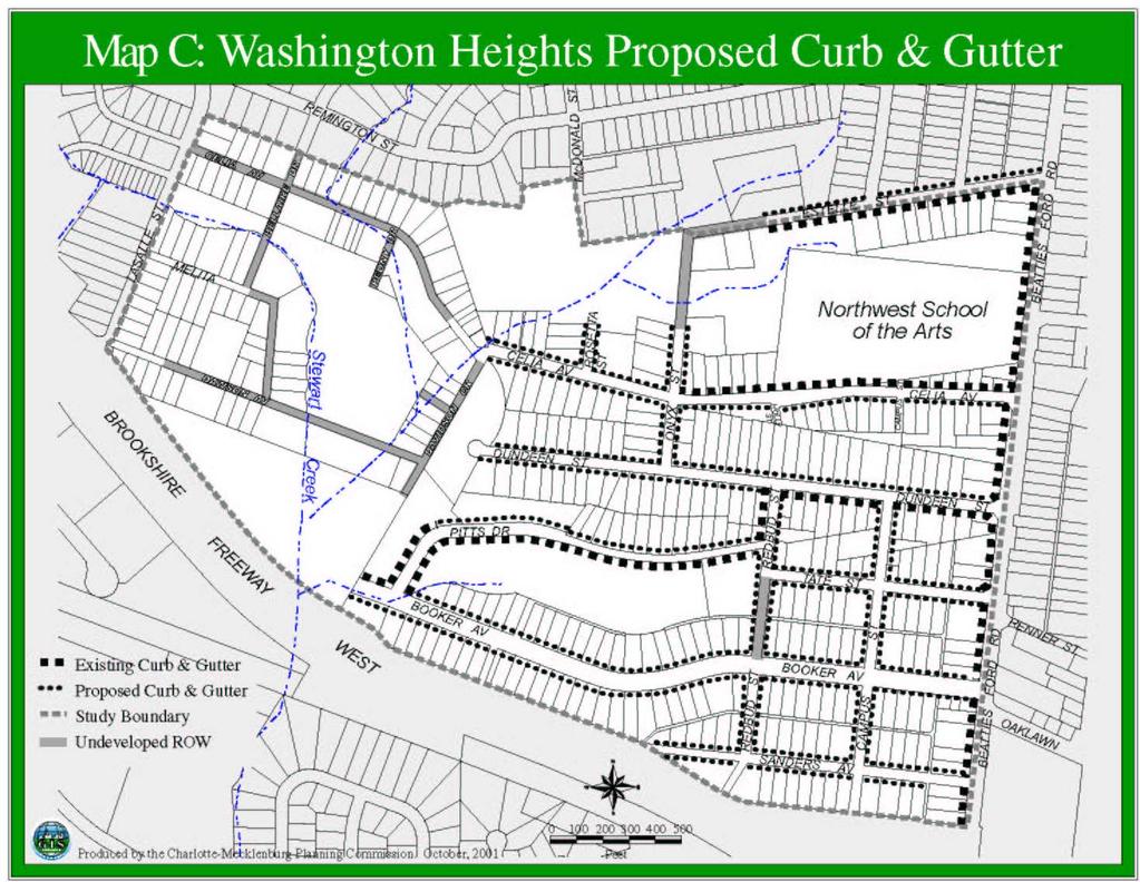
7 An analysis of current ridership figures and patterns along this section of Beatties Ford Road should be undertaken in order to determine the optimal location and number of bus stops/shelters. (Charlotte Area Transit System, Charlotte Department of Transportation, Charlotte Department of Engineering, Neighborhood Organization) The Beatties Ford Road Corridor has been identified as a location for a transit hub. To ensure that this facility takes the needs of the Washington Heights neighborhood into account, a representative from the neighborhood and from the Northwest School of the Arts should be included on the study group established to investigate this proposal. (Charlotte Area Transit System, Northwest School of the Arts, Neighborhood Organization) Consider developing a custom shelter that utilizes architectural elements and materials or some other unique community element, which helps identify this area as one that is unique. (Neighborhood Organization and Charlotte Area Transit System) B. Storm Water Goal and Recommendation Highlights Reduce flooding and storm water drainage problems a) Provide curb and gutter throughout the study area and into adjacent areas to enhance storm water management and minimize the threat of flooding (See Map C). Curb and gutter should also be provided along any newly constructed road sections in the neighborhood such as Redbud Street. In particular install curb and gutter at the following locations (Charlotte Department of Engineering): Both sides of Sanders Avenue along its entire length. Both sides of Booker Avenue along its entire length. Both sides of Tate street along its entire length. Both sides of Dundeen street where it currently does not exist. Both sides of Celia Avenue where it currently does not exist. Both sides of Estelle Street where it currently does not exist. Both sides of Campus Street along its entire length. Both sides of Redbud Street where it currently does not exist. Both sides of Pitts Drive where it currently does not exist. Both sides of Onyx Street along its entire length. Both sides of Rosetta Street. 6
8 7
9 3. Employment and Economic Development Improve linkages between the neighborhood and employment opportunities Sustain neighborhood supportive businesses and increase opportunities for economic growth a) Determine how to best service the neighborhood, so that the residents have efficient access to jobs and other neighborhood services such as shopping centers. The transit schedules should take into account that many of the residents in the neighborhood work shift hours, which means they require off peak service. (Charlotte Neighborhood Development Department, Charlotte Area Transit and Neighborhood Organization) b) Provide information and support to residents on existing programs and centers, such as the JobLink Center at 500 West Trade Street, that have been established to help job seekers find and retain quality jobs. (Charlotte Neighborhood Development Department Employment Services Division) c) Encourage the formation and/or strengthen the merchants organization in the neighborhood. (Neighborhood Organization) d) Encourage the development/redevelopment of the realigned intersection at Booker Avenue and Beatties Ford Road to be attractive, pedestrian-oriented neighborhood scale mixed-use development at this intersection. (Charlotte- Mecklenburg Planning Commission, Charlotte Neighborhood Development Department Business Services Division, Northwest Corridor CDC, Merchants Organization and Neighborhood Organization) e) Improve the appearance of existing retail/commercial development by encouraging property owners to take advantage of façade improvement grants, infrastructure improvement grants and other such programs. (Neighborhood Development Department Business Services Division, Charlotte-Mecklenburg Planning Commission, Northwest Corridor CDC, Merchants Organization and Neighborhood Organization) 8
10 4. Community Safety Improve safety in the neighborhood for area residents and business owners. Maintain and strengthen the relationship between police, area businesses and residents. Encourage citizen involvement, especially youth, in safety programs and to interact with police on an informal basis. Improve lighting in the neighborhood. a) Maintain and strengthen traditional community-based policing efforts. The personal relationships that develop among community police officers, businesses and neighborhood groups are an important crime prevention tool. (Charlotte-Mecklenburg Police Department and Neighborhood Organization) b) Publicize information regarding reductions in crime in the neighborhood. Publicize these reductions through the media, business and community newsletters. (Charlotte-Mecklenburg Police Department and Neighborhood Organization) c) Consider developing a program similar to San Diego s Safe Streets Now. This program trains and empowers residents and business owners on nuisance abatement techniques. With this program, citizens learn to identify and document activity at properties causing nuisances, and bring civil charges against a property owner for non-compliance. (Charlotte- Mecklenburg Police Department and Neighborhood Organization) d) Encourage police, landlords and property managers to share police arrest records on a regular basis. (Charlotte-Mecklenburg Police Department and Neighborhood Organization) e) Reduce crime by concentrating on the special needs of youth by initiating a comprehensive public education program to do the following (Charlotte- Mecklenburg Police Department, Neighborhood Organization and Charlotte Mecklenburg Schools): Increase parents awareness of children s needs. Indicate what services are available. Teach parenting skills. 9
11 5. Human Services The Department of Social Services should increase awareness of existing programs and services available to the community, specifically the youth and elderly. a) Survey the residents of the study area, to determine the human services needs of the community. (Neighborhood Organization and Department of Social Services) b) Develop and distribute a directory of programs and services that addresses the human services needs identified in the above survey. (Social Services Agencies and Neighborhood Organization) c) Encourage potential leaders in the study area to attend leadership development training classes through the City of Charlotte s Neighborhood Development Department and other relevant programs. (Neighborhood Organization, Charlotte Neighborhood Development Department and Department of Social Services) d) Develop relationships with private companies and public agencies through partnerships and mentoring programs. (Neighborhood Organization and Neighborhood Development Department) e) Target youth in the area for various summer job programs. (Charlotte Neighborhood Development Employment Services Division and the Neighborhood Organization) 10
12 6. Community Organizing Strengthen and maintain an active neighborhood organization. a) Increase the organizing and capacity-building skills of neighborhood leaders by providing support and education on problem solving techniques, accessing information and other government services. (Neighborhood Organization and Charlotte Neighborhood Development Department) b) Encourage the Neighborhood Organization to develop a priority work program to begin implementing the recommendations noted in the Concept Plan. (Neighborhood Organization and Charlotte Neighborhood Development Division) 11
13 7. Community Appearance Improve the overall appearance of the neighborhood. Investigate donating alleys to adjacent property owners for personal residential use and maintenance. Provide streetscape improvements along Beatties Ford Road and interior streets. Increase enforcement of litter, zoning and abandoned vehicle ordinances. Encourage residents and business owners to pursue matching grant funds for neighborhood beautification projects. a) Encourage an adopt-a-street program for all major and minor thoroughfares. (Neighborhood Organization, Community Improvement and Charlotte Department of Transportation) b) Initiate streetscape/landscaping projects on key thoroughfares. Also consider ways to reduce visual clutter by removing and/or consolidating overhead utility wires and billboards. (Charlotte Department of Transportation, Charlotte-Mecklenburg Planning Commission, Charlotte City Engineering and the Neighborhood Organization) c) Develop an educational program that reaches businesses, and especially apartment complexes, about appropriate ways to containerize garbage and about the rules for roll-out garbage and bulky item pick-up. (Community Improvement a Division of Charlotte Solid Waste Services and Neighborhood Organization) 12
14 8. Parks, Recreation and Open Space Improve access and encourage the use of parks and recreational facilities for all residents, young and old. Develop the greenway along Stewart Creek. Improve pedestrian, bicycle and vehicular access to L.C. Coleman Park. Encourage Mecklenburg County Parks and Recreation and Charlotte Mecklenburg Schools to explore joint-use opportunities. a) Consider revising the master plan for L.C. Coleman Park in consultation with the neighborhood and Charlotte-Mecklenburg Schools. During this process the recommendations made in the Concept Plan should be taken into consideration. This would be a good opportunity to take advantage of jointuse opportunities and the needs of the neighborhood as expressed in the Concept Plan. (Mecklenburg County Parks and Recreation Department, Neighborhood Organization and Charlotte Mecklenburg Schools) b) Once the revised master plan has been developed, consider accelerating the construction of capital improvements proposed for the L.C. Coleman Park. (Neighborhood Organization and Mecklenburg County Parks and Recreation Department) c) Encourage collaboration to develop and coordinate a comprehensive outreach initiative focusing on the needs of the neighborhood youth, teens and seniors. The initiative should consider traditional and non-traditional recreational, cultural and educational programs and activities. (Mecklenburg County Parks and Recreation Department, the YMCA, Charlotte- Mecklenburg Schools, neighborhood coalitions, churches and other organizations) 13
15 9. Education Encourage students to stay in school. Encourage students to participate in college preparation classes to better prepare them for higher education and/or programs that would better prepare them for employment. Upgrade existing schools in and around the Washington Heights neighborhood to ensure equity in education and facilities and utilize these as key resources in the community. Encourage parental and citizen involvement in the education system. a) Ensure that the physical appearance and maintenance of schools in and near the neighborhood are of the highest standard. (Charlotte-Mecklenburg Schools and Neighborhood Organization) b) Accelerate the efforts to upgrade and improve the schools in and around the neighborhood. (Charlotte-Mecklenburg Schools and Neighborhood Organization) c) Work with area businesses to create more apprenticeship and other work based training opportunities for students. (Northwest Corridor CDC, Neighborhood Organization, Charlotte-Mecklenburg Schools and Neighborhood Merchants Association) d) Investigate ways to change the current system that will allow students who are expelled to stay in school, rather than being turned away from the system altogether. (Charlotte-Mecklenburg Schools and Neighborhood Organization) e) Investigate ways to make school buildings and grounds more accessible and available to residents and the community organization, free of charge, for public meetings and other community events. (Charlotte Mecklenburg Schools, Charlotte Neighborhood Development Department and Neighborhood Organization) f) Stress to the school board members and county commission members to keep in mind that inner city schools experience a different set of issues/problems than do suburban schools. (Charlotte-Mecklenburg Schools and Neighborhood Organization) 14
16 15
Plan-It Greenville (2009) Comprehensive Plan 5-Year Update
 Comprehensive Plan 5-Year Update") Plan-It Greenville (2009) Comprehensive Plan 5-Year Update What is the comprehensive plan: Collecting communitywide data Projecting future population growth Setting communitywide goals Framing policies
Plan-It Greenville (2009) Comprehensive Plan 5-Year Update What is the comprehensive plan: Collecting communitywide data Projecting future population growth Setting communitywide goals Framing policies
The University District envisions, in its neighborhood
 Envisioning the University District Link Light Rail in Seattle s neighborhoods CIY OF SEALE CONCEP-LEVEL SAION AREA PLANNING RECOMMENDAION RESOLUION # 30165 EXHIBI L Vision 08.2000 he University District
UNIVERSITY CITY AREA PLAN. Volume Two: Implementation Plan
 UNIVERSITY CITY AREA PLAN Volume Two: Implementation Plan Transforming the University City MSD into the vibrant, people-oriented place envisioned in the University City Plan will occur incrementally through
Planning Districts INTRODUCTION
 INTRODUCTION To facilitate detailed examination of development prospects for all areas of the community, Delano has been divided into 14 planning districts. The location of these planning districts is
2030 Comprehensive Plan VISION STATEMENT
 RESOURCE DOCUMENT for Steering Committee Meeting #2 July 12, 2017 2030 Comprehensive Plan VISION STATEMENT Steering Committee from 2008 Established the Lauderdale s Vision as: Creating a livable, lovable
Implementation Guide Comprehensive Plan City of Allen
 Implementation Guide 2030 Comprehensive Plan City of Allen DRAFT 2015 Implementation Guide Allen 2030 Comprehensive Plan INTRODUCTION The Comprehensive Plan serves as a guide for the growth and development
implementation10 Village of Greendale Comprehensive Plan: Greendale, Wisconsin. Revisiting a Greenbelt Community
 implementation10 Village of Greendale Comprehensive Plan: 2010 - Village of Greendale Comprehensive Plan: 2010 - Implementation The recommendations of this Plan must be implemented by the Village of Greendale,
CHAPTER 7: Transportation, Mobility and Circulation
 AGLE AREA COMMUNITY Plan CHAPTER 7 CHAPTER 7: Transportation, Mobility and Circulation Transportation, Mobility and Circulation The purpose of the Transportation, Mobility and Circulation Chapter is to
Washington Heights Neighborhood Plan
 Washington Heights Neighborhood Plan 1910 Adopted by Charlotte City Council 25 th February 2002 Looking Ahead Acknowledgements The Charlotte Mecklenburg Planning Commission wishes to acknowledge the contributions
Guiding Principles, Objectives, Strategies and Policies
 Guiding Principles, Objectives, Strategies and Policies Section 1 Introduction These Guiding Principles were adopted as part of the 1999 Athens-Clarke County Comprehensive Plan and are carried over, in
3. VISION AND GOALS. Vision Statement. Goals, Objectives and Policies
 Vision Statement Queen Creek s interconnected network of parks, trails, open spaces and recreation opportunities provide safe and diverse activities and programs that sustain its unique, small town, equestrian
The transportation system in a community is an
 7 TRANSPORTATION The transportation system in a community is an important factor contributing to the quality of life of the residents. Without a sound transportation system to bring both goods and patrons
Plano Tomorrow Vision and Policies
 Plano Tomorrow Vision and Policies PLANO TOMORROW PILLARS The Built Environment The Social Environment The Natural Environment The Economic Environment Land Use and Urban Design Transportation Housing
Beatties Ford Road & Mt. Holly-Huntersville Road Small Area Plan
 Beatties Ford Road & Mt. Holly-Huntersville Road Small Area Plan Town of Huntersville October 2005 Town of Huntersville Planning Department 101 Huntersville Concord Road Post Office Box 664 Huntersville,
A larger version of this map is located on the last page of this PDF.
 MAP Committee Input McLoughlin Area Draft Vision Map A larger version of this map is located on the last page of this PDF. 1. The map above is intended to portray a vision for the McLoughlin area. It highlights
Route 1 Corridor Study
 Route 1 Corridor Study Westbrook, Connecticut A Vision for the Connecticut Shoreline Public Informational Meeting July 28, 2015 Lower Connecticut River Valley Council of Governments Fitzgerald & Halliday,
SUMMERSIDE / MT. CARMEL REINVESTMENT CORRIDOR COMMUNITY DEVELOPMENT STRATEGY
 SUMMERSIDE / MT. CARMEL REINVESTMENT CORRIDOR COMMUNITY DEVELOPMENT STRATEGY FEBRUARY 2013 I. Location of the Summerside/Mt. Carmel Reinvestment Corridor The Summerside/Mt. Carmel Reinvestment Corridor
JANUARY 19, 2011 CENTRAL AVENUE-METRO BLUE LINE TRANSIT-ORIENTED DEVELOPMENT IMPLEMENTATION PROJECT COMMUNITY FORUM
 CENTRAL AVENUE-METRO BLUE LINE TRANSIT-ORIENTED DEVELOPMENT IMPLEMENTATION PROJECT COMMUNITY FORUM JANUARY 19, 2011 THE MARYLAND-NATIONAL CAPITAL PARK AND PLANNING COMMISSION PRINCE GEORGE S COUNTY PLANNING
In surveys, Dallas residents say what they want to change most
 NEIGHBORHOODS ELEMENT In surveys, Dallas residents say what they want to change most in the city is its appearance they want it to look beautiful, with trees and pedestrian-friendly neighborhoods. The
A BLUEPRINT FOR BROCKTON A CITY-WIDE COMPREHENSIVE PLAN
 A BLUEPRINT FOR BROCKTON A CITY-WIDE COMPREHENSIVE PLAN Public Meeting October 2016 1 Plan Summary and Discussion Public Meeting May 4 2017 City of Brockton Bill Carpenter, Mayor Department of Planning
Citizen Comment Staff Response Staff Recommended Revision Planning Committee
 Citizen Comment Staff Response Staff Recommended Revision Planning Committee Area No. 1: Owner desires retail land uses. Area No. 1a: Owner of two small parcels adjacent to Area No. 1 desires retail land
Asbury Chapel Subdivision Sketch Plan
 Asbury Chapel Subdivision Sketch Plan PART 1: PROJECT SUMMARY Applicant: NVR Inc. Project Size: +/- 76.13 acres Parcel Numbers: 02101112,02116101,02116112, 02116113 Current Zoning: Transitional Residential
Town Center (part of the Comprehensive Plan)
") Town Center (part of the Comprehensive Plan) Mercer Island Town Center Looking North (2014) In 1994, a year-long process culminated in a set of design guidelines and code requirements for the Town Center
Town Center (part of the Comprehensive Plan) Mercer Island Town Center Looking North (2014) In 1994, a year-long process culminated in a set of design guidelines and code requirements for the Town Center
Economy Vision Statements: Social Wellbeing Vision Statements: Natural Environment Vision Statements:
 Economy Vision Statements: 1. Our business environment makes us a region of choice for new employers as we encourage entrepreneurship and have a vibrant, diversified and resilient regional economy. 2.
Hockessin Community Redevelopment Plan
 Hockessin Community Redevelopment Plan 3.1 Introduction The Community Redevelopment Plan for the Village of Hockessin is the result of the people s vision for a distinct village center that serves as the
Definitions. Average Daily Traffic Demand (ADT): The actual number or projected number of cars that pass a point in a 24-hour period.
: The actual number or projected number of cars that pass a point in a 24-hour period.") Definitions Access Management: A combination of physical techniques and transportation policies used to control the flow of traffic between roads and the surrounding lands. Alternative City Form Scenarios:
Definitions Access Management: A combination of physical techniques and transportation policies used to control the flow of traffic between roads and the surrounding lands. Alternative City Form Scenarios:
4.1.3 LAND USE CATEGORIES
 4.1.3 LAND USE CATEGORIES a. City Center District The City Center District incorporates the existing character and mix of uses in downtown Belmont to encourage redevelopment and new development in keeping
DALY CITY VISIONING PROCESS COMMUNITY WORKSHOP 3 MAY 8, 2008
 DALY CITY VISIONING PROCESS COMMUNITY WORKSHOP 3 MAY 8, 2008 PROCESS General Plan - a statement of the community s values, vision and aspirations for now and into the future... Timeframe LONG TERM - 2030
Chapter 1: Introduction
 Chapter 1: Introduction The Penn Avenue Community Works Corridor Vision and Implementation Framework presents an integrated communitybased vision and a coordinated, long-term implementation framework for
City of Bristol Route 6 Corridor Implementation Program
 City of Bristol Route 6 Corridor Implementation Program FITZGERALD & HALLIDAY, INC. Innovative Planning, Better Communities June 2017 Route 6 Corridor Plan IMPLEMENTATION PROGRAM The following Implementation
V. Vision and Guiding Principles
 V. Vision and Guiding Principles The Master Plan for the Powers Ferry Corridor seeks a foundation in the desires of the community. At times, various elements of the community offered opposing viewpoints,
SAN RAFAEL GENERAL PLAN 2040 INTRODUCTION AND OVERVIEW
 SAN RAFAEL GENERAL PLAN 2040 INTRODUCTION AND OVERVIEW Steering Committee Presentation February 14, 2018 Purpose of General Plan Guide land use and development decisions Coordinate transportation, infrastructure,
CITY OF PUYALLUP. Background. Development Services
 CITY OF PUYALLUP Development Services 333 South Meridian Puyallup WA 98371 To: City Council From: Katie Baker, AICP, Planning Division Re: South Hill Neighborhood Plan Adoption Date: (Meeting date: February
Urban Design Manual PLANNING AROUND RAPID TRANSIT STATIONS (PARTS) Introduction. Station Study Areas
 Introduction. Station Study Areas") 111111 PLANNING AROUND RAPID TRANSIT STATIONS (PARTS) Introduction The ION rapid transit system will link Waterloo, Kitchener and Cambridge through a central transit corridor (CTC). There are a number
111111 PLANNING AROUND RAPID TRANSIT STATIONS (PARTS) Introduction The ION rapid transit system will link Waterloo, Kitchener and Cambridge through a central transit corridor (CTC). There are a number
Support the implementation of Cape Coral's Comprehensive Plan. Protect and utilize the unique natural resources in the City.
 7.0 OVERVIEW - RECOMMENDATIONS Chapter 7 The preparation of the Cape Coral Parks and Recreation Master Plan spanned a period of approximately 12 months. Plan preparation included the input of a wide range
C. Westerly Creek Village & The Montview Corridor
 C. Westerly Creek Village & The VISION Community Vision When the goals of the city are achieved Westerly Creek Village, a distinctive community defined by Montview Boulevard and Westerly Creek, is a strong
8implementation. strategies
 PROGRAM STRATEGIES 8implementation strategies T he implementation actions of this chapter are designed to support and carry out the land use, economic development, transportation, urban design, and program
Silverdale Regional Center
 Silverdale Regional Center Vision for Silverdale Regional Center The Silverdale Regional Center Plan (Plan) will guide the evolution of the Silverdale Regional Center from a collection of strip malls and
CHAPTER VIII Implementation
 CHAPTER VIII Implementation VIII. Implementation The vision for the Marlboro Pike Corridor will require that a variety of participants work together to make it a reality. The following action steps outline
EXISTING COMPREHENSIVE PLAN
 EXISTING COMPREHENSIVE PLAN Town Center Land Use Element: V. LAND USE POLICIES Town Center Mercer Island's business district vision as described in "Your Mercer Island Citizen-Designed Downtown" was an
TRANSPORTATION ELEMENT GOALS, OBJECTIVES, AND POLICIES
 TRANSPORTATION ELEMENT GOALS, OBJECTIVES, AND POLICIES GOAL 2 The City shall provide a safe, convenient, effective, and energy efficient multimodal transportation system which is coordinated with the Future
Neighborhood Districts
 NEIGHBORHOOD DISTRICTS SEVEN MAIN DISTRICTS Neighborhood Districts While the Development Plan provides a broad-scale overview of the neighborhood, this section focuses on uses and relationships at the
The Vision. Photo provided by The Minervini Group. 46 Vision, Objectives & Strategies
 Vision, Objectives & Strategies The is the public framework and guide for future development of the Grand Traverse Commons. The establishes public polices for infrastructure, the preservation of natural
The Five Components of the McLoughlin Area Plan
 The Five Components of the McLoughlin Area Plan This documents contains the complete language of the five components of the McLoughlin Area Plan: The Vision Statement The Values The Guiding Principles
Rolla Comprehensive Plan Update, 2005 COMMUNITY ISSUES MEMORANDUM 11/1/2004
 COMMUNITY ISSUES MEMORANDUM 11/1/2004 Introduction Throughout the planning process, but particularly during the early phases of the update, various individuals and groups will be asked to identify and
HOUSING ELEMENT GOALS, OBJECTIVES, AND POLICIES
 HOUSING ELEMENT GOALS, OBJECTIVES, AND POLICIES Goal 6 Maintain and enhance the supply of decent, safe, energy efficient and affordable housing and maximize viable options and opportunities for present
City of Hermosa Beach Administrative Policy #
 City of Hermosa Beach Administrative Policy # SUBJECT: Living Streets Policy Date: Approved by: City Council Authority: Public Works Department & Community Development Department Mayor, PURPOSE The City
Chapter 4: The Vision
 Chapter 4: The Vision This plan is organized around the community vision detailed in this chapter. The vision describes the collective thoughts, values, and hopes of the community for its future. The community
THE POLICY FRAMEWORK FOR WALKABLE COMMUNITIES. Community Technical Assistance Program Building Active Communities Institute March 2016
 THE POLICY FRAMEWORK FOR WALKABLE COMMUNITIES Community Technical Assistance Program Building Active Communities Institute March 2016 ACTIVE COMMUNITIES BACK THEN ACTIVE COMMUNITIES BACK THEN Lifestyle
REQUEST Current Zoning: O-15(CD) (office) Proposed Zoning: TOD-M(CD) (transit oriented development mixed-use, conditional)
 (office) Proposed Zoning: TOD-M(CD) (transit oriented development mixed-use, conditional)") Rezoning Petition 2016-117 Zoning Committee Recommendation January 4, 2017 REQUEST Current Zoning: O-15(CD) (office) Proposed Zoning: TOD-M(CD) (transit oriented development mixed-use, conditional) LOCATION
Rezoning Petition 2016-117 Zoning Committee Recommendation January 4, 2017 REQUEST Current Zoning: O-15(CD) (office) Proposed Zoning: TOD-M(CD) (transit oriented development mixed-use, conditional) LOCATION
MAIN STREET ECONOMIC DEVELOPMENT STRATEGY
 MAIN STREET ECONOMIC DEVELOPMENT STRATEGY A PATHWAY TO A BETTER POUGHKEEPSIE DRAFT Working Paper #2: Planning Strategies Submitted December 1 st, 2015 to the City of Poughkeepsie LAND USE LAW CENTER PACE
BROOKLYN PARK / 85TH AVE LRT STATION CDI DEVELOPMENT GUIDELINES DRAFT
 August 2018 Page intentionally left blank The Brooklyn Park Library adjacent to the 85th Ave LRT Station Area. OVERVIEW The Blue Line LRT Extension / Bottineau corridor offers a unique opportunity to leverage
COMMUNITY DESIGN. GOAL: Create livable and attractive communities. Intent
 COMMUNITY DESIGN Intent An attractive, well-designed County will attract quality development, instill civic pride, improve the visual character of the community, and create a strong, positive image for
University of the District of Columbia Van Ness Campus Master Plan Community Open House 3. December 8, 2010
 University of the District of Columbia Van Ness Campus Master Plan Open House 3 December 8, 2010 Introductions Sequence of Work: Campus Master Plan BEGIN: INTRODUCE AND START WORK Project Initiation Team
Draft Memorandum #1: Goals and Vision for Revitalization
 Keizer Revitalization Plan Draft Memorandum #1: Goals and Vision for Revitalization Submitted to: City of Keizer April 12, 2018 (revised) Prepared By: Angelo Planning Group and Otak, Inc. Project No. 17482.A
LUNDY S LANE COMMUNITY IMPROVEMENT PLAN STUDY
 PUBLIC INFORMATION MEETING #2 October 12, 2016 LUNDY S LANE COMMUNITY IMPROVEMENT PLAN STUDY AGENDA 5:00 to 5:30pm: Open House 5:30 to 6:15pm: Presentation 6:15 to 7:00pm: Individual paced workshop with
Executive Summary. NY 7 / NY 2 Corridor
 Executive Summary NY 7 / NY 2 Corridor Transportation and Land Use Study December 2005 Prepared for: Town of Colonie Capital District Transportation Committee Prepared by: Introduction: Land use decisions
Status Update (2006 vs. Now) Citizen s Advisory Committee February Plan for Prosperity
 Citizen s Advisory Committee February Plan for Prosperity") Status Update (2006 vs. Now) Citizen s Advisory Committee February 2018 Plan for Prosperity 2000 2017 2000 2017 Gardnerville Population 6,000 5,760 5746 5,500 5,000 5,067 5,550 5,165 5,394 5,412 5,250
Status Update (2006 vs. Now) Citizen s Advisory Committee February 2018 Plan for Prosperity 2000 2017 2000 2017 Gardnerville Population 6,000 5,760 5746 5,500 5,000 5,067 5,550 5,165 5,394 5,412 5,250
Small Area Plan. South Gateway
 Small Area Plan Adopted May 12, 2008 South Gateway Purpose. The South Gateway Small Area Plan defines the City s expectations for the future of the southern entrance to the City at Interstate 85 and Highway
Illustration of Eastlake Farmer s Cooperative Grain Elevator. Chapter 5: implementation 5-1
 Illustration of Eastlake Farmer s Cooperative Grain Elevator Chapter 5: implementation 5-1 chapter 5: implementation Introduction The Eastlake Subarea Plan includes a wide range of recommendations intended
Gold Line Bus Rapid Transit Transit Oriented Development (BRTOD) Helmo Station Area Plan
 Helmo Station Area Plan") Appendix F Gold Line Bus Rapid Transit Transit Oriented Development (BRTOD) Helmo Station Area Plan Introduction and Purpose of the Plan The Gold Line Bus Rapid Transit facility is an eleven-mile dedicated
Appendix F Gold Line Bus Rapid Transit Transit Oriented Development (BRTOD) Helmo Station Area Plan Introduction and Purpose of the Plan The Gold Line Bus Rapid Transit facility is an eleven-mile dedicated
Public Open House #1
 Public Open House #1 TONIGHT S AGENDA Welcome Project Overview The Big Picture The Station Area The Analysis Thoughts about Future Change Breakout Group Discussions Summation / Next Steps Project Overview
North Fair Oaks Community Plan Summary and Information
 North Fair Oaks Community Plan Summary and Information WHAT IS THE NORTH FAIR OAKS COMMUNITY PLAN? The North Fair Oaks Community Plan is part of the San Mateo County General Plan, and establishes policies
PROTECT AND PROMOTE QUALITY OF LIFE AND LIVABILITY FOR THE CITIZENS OF GAINESVILLE THROUGH QUALITY URBAN DESIGN.
 Goals, & Urban Design Element PROTECT AND PROMOTE QUALITY OF LIFE AND LIVABILITY FOR THE CITIZENS OF GAINESVILLE THROUGH QUALITY URBAN DESIGN. GOAL 1 By 2003, the City shall adopt urban design standards
Strategic Target: Utilize Pay-For-Use Services Whenever Possible
 2004 Strategic Planning Report The 2003 Strategic Planning Steering Committee compiled and presented this report to the Olathe City Council on March 25, 2004. This is the result of community meetings conducted
The Lincoln Neighborhood Corridor Plan. The LiNC
 October 1, 2014 Planning Commission Study Session The Lincoln Neighborhood Corridor Plan The LiNC Purpose of Tonight s Meeting Introduction to The LiNC Review of Existing Conditions and Community Identified
SPRINGHILL LAKE TRANSIT VILLAGE
 Greenbelt Metro Area Sector Plan - Subarea Design Policies and Guidelines - Springhill Lake Transit Village 113 SPRINGHILL LAKE TRANSIT VILLAGE Residential Neighborhood and Village Center CONCEPT Springhill
Somers Point Master Plan
 Somers Point Master Plan Progress Report and Public Meeting August 20, 2014 Master Plan Reexamination Municipal Land Use Law require that all municipalities reexamine their master plan every ten years.
McDonald s Restaurant - Purcellville Town of Purcellville Special Use Permit Statement of Justification July 24, 2014
 Introduction / Written Statement McDonald s Restaurant - Purcellville McDonald s Corporation is proposing to redevelop the existing McDonald s eating establishment with a drive-through located at 121 N
Public input has been an important part of the plan development process.
 Lakewood s Comprehensive Plan recognizes that transportation helps shape the community, and that the way the community provides for the safe and efficient movement of people affects the character of the
This Review Is Divided Into Two Phases:
 Semiahmoo Town Centre Review The purpose of this review: To review the Semiahmoo Town Centre Concept Plan, originally approved in 1993, to ensure that this centre will continue to serve the needs of South
Walnut Creek BART Station
 Walnut Creek BART Station Mixed Use Transit Oriented Project Design Review Commission Study Session May 17, 2006 Applicant: Walnut Creek Transit Lifestyles Associates Joint Venture: Transit Village Associates
Dignowity Hill Neighborhood Plan & Eastside Reinvestment Plan
 Dignowity Hill Neighborhood Plan & Eastside Reinvestment Plan Rebecca Paskos, Senior Planner Neighborhood & Urban Design Division Planning & Community Development Department City of San Antonio (210) 207-7816
12 Intergovernmental Coordination
 Intergovernmental Coordination Supporting Data The purpose of the Intergovernmental Coordination Element is to identify and resolve incompatible goals, objectives, policies and development proposed in
Gloucester County s Comprehensive Plan. The Community Connection
 Gloucester County s Comprehensive Plan The Community Connection Current Comp Plan Adopted in 1991 with a 20 year planning horizon Updated in 1995 with Part V- Implementation Recommendations and Appendix
Pedestrian and Bike Bridge LOGO
 6.2.2 Pedestrian and Bike Bridge The proposed pedestrian and bike crossing re-envisions the existing bridge at Pismo Creek on Cypress Street. The bridge is currently underutilized by vehicular through
SECTION II SECTION II STATEMENT OF GOALS, OBJECTIVES, PRINCIPLES, ASSUMPTIONS, POLICIES AND STANDARDS
 STATEMENT OF GOALS, OBJECTIVES, PRINCIPLES, ASSUMPTIONS, POLICIES AND STANDARDS 1 2 STATEMENT OF GOALS, OBJECTIVES, PRINCIPLES, ASSUMPTIONS, POLICIES AND STANDARDS INTRODUCTION The New Jersey Municipal
CHARLES PUTMAN CHARLES PUTMAN AND ASSOCIATES, INC
 MEMORANDUM CHARLES PUTMAN & ASSOCIATES, INC. LAND DEVELOPMENT CONSULTANTS PLANNING ZONING PERMITTING 4722 NW Boca Raton Boulevard, Suite C-106 Boca Raton, Florida 33431 Phone: 561/994-6411 FAX: 561/994-0447
Living in Albemarle County s Urban Places
 Living in Albemarle County s Urban Places ALBEMARLE COUNTY, VIRGINIA A Closer Look at Albemarle s Approach to Managing Growth and Creating Quality Urban Environments www.albemarle.org Page 2 Living in
Chapter 3. Community Vision and Goals
 Chapter 3. Community Vision and Goals 3.1 Public Involvement Charlevoix s master plan was prepared in a way that maximized public participation. Dating back to 2004, the Planning Commission and staff held
PSRC REVIEW REPORT & CERTIFICATION RECOMMENDATION
 PSRC REVIEW REPORT & CERTIFICATION RECOMMENDATION KITSAP COUNTY COUNTYWIDE PLANNING POLICIES July 2, 2012 BACKGROUND A major emphasis of the Washington State Growth Management Act (GMA) is the need to
The petition proposes to rezone the site to allow all uses permitted in the B-1 (neighborhood business) district.
 district.") Rezoning Petition 2018-040 Pre-Hearing Staff Analysis June 18, 2018 REQUEST Current Zoning: R-17MF (multi-family residential) Proposed Zoning: B-1 (neighborhood business) LOCATION Approximately 0.38 acres
Rezoning Petition 2018-040 Pre-Hearing Staff Analysis June 18, 2018 REQUEST Current Zoning: R-17MF (multi-family residential) Proposed Zoning: B-1 (neighborhood business) LOCATION Approximately 0.38 acres
West Ocala Vision & Community Plan City Council Work Session. Presented by West Ocala Community Plan Steering Committee
 West Ocala Vision & Community Plan City Council Work Session Presented by West Ocala Community Plan Steering Committee November 29,2011 Ocala 2035 Vision West Ocala Community Vision & Master Plan West
Preliminary Plan Framework: Vision and Goals
 Preliminary Plan Framework: Vision and Goals Draft: May 2015 Introduction Since the Town of Milliken s comprehensive plan was last updated in 2010, the community was heavily impacted by the 2013 flood,
1 October Dear Citizens of Charlotte and Mecklenburg County,
 1 October 2011 Dear Citizens of Charlotte and Mecklenburg County, As co-chairs of the Center City 2020 Vision Plan Steering Committee, we are proud to present the Center City 2020 Vision Plan, which sets
Proposed Comprehensive Plan Strategies DRAFT for discussion June 28, 2017
 Proposed Comprehensive Plan Strategies DRAFT for discussion June 28, 2017 Land Use Rural Areas Refine the Farm and Forest area (FF) Update FF boundaries to account for existing lots less than five acres
Clairtrell Area Context Plan
 Clairtrell Area Context Plan March 2005 Urban Development Services City Planning Contents 1. Introduction... 4 2. Development Structure... 6 2.1 Streets... 7 2.1.1 Sheppard Avenue and Bayview Avenue...
1 Introduction. 4 Environmental Integrity. 7 Community Facilities
 2037: A CALL TO ACTION 2017 COMPREHENSIVE PLAN EXECUTIVE SUMMARY is the purpose of the Q: What Comprehensive Plan? The comprehensive plan serves as a guide for the community s physical, social, and economic
Huntersville 2030 Community Plan Implementation Schedule
 Huntersville 2030 Community Plan Implementation Schedule The Huntersville 2030 Community Plan Implementation Schedule is a summary of all Policy and Action items included in the 2030 Community Plan. This
TOD 101 CREATING LIVABLE COMMUNITIES WITH TRANSIT
 1 CREATING LIVABLE COMMUNITIES WITH TRANSIT What are transit Centered Communities? Benefits of Partnerships to Support and Implement What You Will Learn Portland s Pearl District Your Trainers Today Catherine
38 Queen s University Campus Master Plan Part 1
 38 Queen s University Campus Master Plan Part 1 46 The Campus at the City Scale Chapter 4 The Campus at the City Scale 39 Queen s is an urban University centrally located in Kingston. Decisions made by
FUTURE DEVELOPMENT AREAS
 FUTURE DEVELOPMENT AREAS Refer to the Future Development Map on Page 2. Suburban Residential (Less than 3 units/acre) Suburban Residential neighborhoods form the backbone of Smyrna. While growth and redevelopment
FUTURE LAND USE ELEMENT
 FUTURE LAND USE ELEMENT GOAL I: To create and sustain a great place to live, play, and prosper Objective 1: The City of Ocala shall incorporate the principles and strategies of the Ocala 2035 Vision into
9IMPLEMENTATION AND PHASING
 9IMPLEMENTATION AND PHASING Purpose A key objective of the Railyard Master Plan is the integration of the public and private realm to provide a network of places that connect to and complement Commercial
Chapter 4. Linking Land Use with Transportation. Chapter 4
 Chapter 4 Linking Land Use with Transportation Chapter 4 59 Chapter 4 Linking Land Use with Transportation Community Design and Transportation Program Introduction Since the 1950s, the predominant development
Welcome to the Oakridge Centre Open House
 Welcome to the Oakridge Centre Open House Why is the City hosting this event? This open house is to inform you of a rezoning application submitted to the City of Vancouver to amend the existing CD-1 (Comprehensive
Executive Summary. The Mebane CLP is not a regulatory document, but is intended to guide land development decisions. The plan includes:
 Executive Summary P URPOSE AND O RGANIZATION OF THE P LAN The City of Mebane, with input from citizens and an appointed CLP Advisory Committee, adopted Mebane by Design, a Comprehensive Land Development
Making Transit Oriented Development Work For Boonton, NJ
 Making Transit Oriented Development Work For Boonton, NJ Bloustein School of Planning and Public Policy Studio Dan Burton Loannie Dao Webster Slater Brandon Williams Ian Watson Maria Laham Nicola Mammes
Transportation. Strategies for Action
 Transportation A major priority for the Overlake Neighborhood is to develop a multimodal transportation system. To achieve this system, a balance has to be found among travel, circulation and access needs;
Today Land & People. Northeast Nampa Gateway District. Employment. Land Use Characteristics. Demographics. Current Zoning
 Today Land & People Employment Major employers include Saint Alphonsus, the College of Western Idaho, the Auto Mall, Sorrento Lactalis and Walmart. 3,004 jobs in 2010 (COMPASS-CIM 2040 TAZ data) 4,345