t?ontario Ministere des Affaires municipales et du Logement Bureau des services aux municipalites Centre de l'ontario 777. rue Bay, 2 nd elage
|
|
|
- Camilla Anthony
- 6 years ago
- Views:
Transcription
1 Ministry of Municipal Affairs and Housing Municipal Services Office Central Ontario 777 Bay Street, 2 nd Floor Toronto ON M5G 2E5 Phone: Fax: Toll-Free: Ministere des Affaires municipales et du Logement Bureau des services aux municipalites Centre de l'ontario 777. rue Bay, 2 nd elage Toronto ON M5G 2E5 Telephone: Telecopieur: Sans frais: "~ t?ontario October 27,2010 Ron Glenn, MCIP, RPP Director of Planning and Chief Planning Official Region of Halton Legislative and Planning Services 1151 Bronte Road Oakville, ON L6M 3L1 Dear Mr. Glenn: Re: Proposed Draft Decision on Regional Official Plan Amendment No. 38 MMAH File No.: 24-0P I am pleased to share with you a proposed partial draft decision, as prepared by my staff, to address the majority of policies in Regional Official Plan Amendment No. 38 (ROPA 38). The Region of Halton adopted Official Plan Amendment No. 38 to bring the Regional OP into conformity with the Growth Plan for the Greater Golden Horseshoe, Greenbelt Plan, and the Provincial Policy Statement, ROPA 38 was the subject of a multi-ministry review through the One Window Planning Service which examined both the draft and adopted versions of the plan. MMAH staff met and worked closely with Regional staff on numerous occasions and productively addressed many key areas of ROPA 38. The Ministry would like to commend the Region for its notable efforts to improve the policy framework of the Regional Official Plan through the implementation of strong environmental protection policies, an appropriate development phasing strategy, meeting Growth Plan intensification and greenfield density targets, and the protection of employment lands. The proposed partial draft decision includes several modifications to ROPA 38, along with a number of new modifications, including the addition of new policies. The proposed modifications to the OP will improve consistency with the Provincial Policy Statement and improve conformity with the Growth Plan for the Greater Golden Horseshoe. The proposed draft decision identifies areas of the amendment that are supported and areas where modifications are recommended; the draft decision: supports the majority of the Urban Area and growth management policies, including the distribution of growth as set out in table 1 of ROPA 38; recognizes the Agricultural Rural Area and Regional Natural Heritage System policy framework (outside the Greenbelt Plan Area);

2 strengthens policies to protect prime agricultural areas and ensure that agriculture as a land use is not hindered; supports harmonization of the OP with the policies of the Parkway Belt West Plan; removes specific references and mapping of Future Strategic Employment Areas, but includes alternative wording to support Regional goals in this regard; incorporates new definitions to strengthen the Regional policy framework. Matters not Addressed in the Draft Decision: At this time, MMAH is not in a position to provide draft modifications or a draft decision for a number of key areas of the OP. It is anticipated that through further discussion with regional staff the following matters can be addressed, prior to issuance of a final decision. The Ministry continues to have concerns with the Regional approach with respect to Greenbelt Plan conformity, and has advised the Region that it must identify an appropriate approach to address these concerns. Further modifications to the Greenbelt Plan related policies and mapping are therefore anticipated. The Ministry has also identified concerns with the Region's land budget methodology in relation to the proposed employment area land supply. As we have identified previously and consistently across the province, the Ministry does not support the use of vacancy rates and underutilization variables when determining future land needs. Further discussion between the Ministry and Region will be necessary to address these concerns. In the interim, as per discussions with Regional staff, the Ministry is proposing to withhold a decision on the designation of approximately 110 ha of new employment land (see Map 1 attached). This decision would be withheld pending the outcome of such discussions and the findings related to future transportation corridors planned for this area. Other parts of the OP have also not been addressed through this draft partial decision, including: certain remaining agricultural policies, natural heritage policies, mineral aggregate policies, land use schedules, deferrals and referrals, and other technical matters such as EIS requirements. Accordingly, additional modifications to the amendment to address these matters are expected. The rationale for the policy modifications and the non-decision areas is provided in the appendix to this letter. The Draft Decision: Proposed draft modifications are attached for your review. Please note, these modifications do not reflect any technical modifications the Region may have requested. MMAH is committed to continuing the ongoing dialogue with the Region in order to address these matters and prepare a supplementary draft decision, wherein the balance of the ROPA will be addressed. Please contact Mark Christie at the Municipal Services Office - Central Region at (416) if you have any questions or require additional information.

3 Greenbelt Plan Policy Area APPENDIX The current policy framework proposed by ROPA 38 identifies the Greenbelt Plan Area, including the Greenbell Natural Heritage System, but only provides basic policy direction to local municipalities who are to provide more detailed implementation policies and mapping, in accordance with the Greenbelt Plan. In order to ensure consistency across the Province, the Ministry has directed the Region to implement Greenbell policies into its policy framework that will provide clear direction to local municipalities as they amend their own Official Plans to ensure Greenbelt conformity. Furthermore, it is noted that the Regional Plan takes two approaches to conformity, (1) for lands north of the Niagara Escarpment and (2) for lands south of the Niagara Escarpment. The Ministry would like to see a policy framework wherein the Greenbelt Plan is applied consistently across the Region while still ensuring that the local context, where appropriate, is addressed. Further discussion between the Region and Ministry staff will be necessary to address this issue and to collaboratively develop policy modifications to ensure conformity with the Greenbelt Plan. Future Strategic Employment Areas The Region is proposing to identify Future Strategic Employment Lands (Map 1C) which are not presently within the Urban Area. Provincial Policy does not support the delineation of land for urban uses that exceed the 20-year planning horizon as noted in both in the Growth Plan and the Provincial Policy Statement. The Ministry is proposing to delete future strategic employment areas as shown on Map 1C and has included modifications to delete and/or revise the following related policies: 51.2(2), 77.3,139.3(2),139.6,139.7, and The Ministry has proposed a modification to Section 77(7)f)vii) including language directs that the Region will designate lands for employment use which are in the vicinity of strategic infrastructure or transportation facilities, when such lands are brought into the urban area pursuant to a municipal comprehensive review, to help protect these areas from potential residential development. Mineral Resource Extraction Areas The Region has advanced a policy approach for mineral aggregate resources which appears to be more restrictive than the policies in the Provincial Policy Statement and the Greenbelt Plan. This is contrary to provincial policy that directs municipalities to protect aggregate resources for the long term and ensure that development activities do not preclude or hinder the current or future extraction of these resources. In addition, the Region has proposed policies which relate to matters beyond their jurisdiction, such as licensing which is regulated under the Aggregate Resources Act. Further discussion between the Region and Ministry staff is necessary to address these concerns. Employment Land Needs The Region's land budget methodology used to support the designation of additional employment land does not appear to fully comply with provincial guidelines and policy. The province does not support the use of vacancy rates or underutilization variables. It appears that these assumptions may have led to an overestimation of land needed for future employment growth in Hallon Region. Further discussion is required between the Region and the province to address this issue. In the interim, the Ministry is proposing to withhold a decision on approximately 110 ha of new employment land, as shown on Map 1, in order to satisfy these concerns. The area identified for this purpose is also subject to an Environmental Assessment process to identify a future transportation connection to Highway

4 407 (Halton Peel Boundary Area Transportation Study). Natural Features The Region's proposed natural heritage system policy framework intends to protect all natural heritage features equally within the system. Fine tuning of the policies regarding the protection of the natural heritage system are required to provide sufficient clarity with respect to the protection of natural features (wetland, woodlots, etc) to meet the intent of the Provincial Policy Statement. Mapping Map 1E: The Region has identified prime agricultural areas on Map 1E. The boundary of these areas should be further examined to ensure that prime agricultural areas are comprised of appropriate contiguous blocks and meet the intent of the Provincial Policy Statement. Map 1F: This map includes mineral resource areas that have already been extracted or do not represent viable sources of mineral aggregate. Further discussion is required between the Region and the Ministry to clarify which areas should be removed from Map 1F. Map 3: The Region has not identified conceptual routes for proposed provincial transportation corridors, including the GTA West and Niagara GTA corridors. Given that the formal EA processes are underway for both the GTA West and Niagara GTA corridors, the Region should recognize these on-going planning initiatives for infrastructure which may have significant impact on the transportation system in Halton Region. In this regard, the Ministry has included a modification to 173(1) of the Official Plan and identified the conceptual corridors on Map 3, as shown in the attached draft decision.
5 DRAFT DECISION With respect to Official Plan Amendment No. 38 Subsection 17(34) of the Planning Act I hereby approve in part Amendment No. 38 to the Official Plan to the Region of Halton, as adopted by By-law No , as modified and shown in tracked changes in Parts A and B of this decision. Only sections of ROPA 38 where modifications are proposed, to date, are shown below. Note: Modifications to the amendment constitute additions and deletions. Additions are shown in red text and deletions to the amendment are in single strikethrough as follows: PART A MODIFICATIONS to TABLE A Details of the Amendment: Item Section Number Details of the Amendment (2) Future Strategic Employment Areas, as shown on Map 1C, The Regional Structure is accompanied by a growth strategy for Halton based on the distribution of population and employment targets for the planning horizon of year 2031 as contained in Table 1 as well as by other infrastructure elements such as transportation systems and urban services (1) objectives and policies relating to areas of constraint as shown on Map 1 orand Maps 1B through 1G; All development within the Greenbelt Plan Protected Countryside Area and Natural Heritage System (Greenbelt Plan) as shown on Map 1A is subject to the provisions of the Greenbelt Plan Act and the Greenbelt Plan, as well as applicable policies of this Plan, Local Official Plan, and Local Zoning Bylaws The Urban Area is planned to accommodate the distribution of population and employment targets for the Region and the four Local Municipalities as shown in Table 1. Such a distribution is targets are expected to be reached by the planning horizon year of (1) Prepare, in consultation with the Local Municipalities, and adopt population and employment forecasts in accordance with the distribution of those targets population and employment contained in Table 1. Such forecasts shall: 66 77(3) Require the Local Municipalities and encourage public agencies in Halton to adopt and use the population and employment forecaststargets established under Sections 77(1), as well as the population and employment distributionthose contained in Table 1 and the targets contained in Table 2, as the basis for their plans and provision of services. Oct Draft - for discussion only 1/12
6 67 77(4) Require the Local Municipalities to demonstrate with sufficient details, through their respective Official Plans and amendments thereof, how the population and employment distribution targets in Tables 1 and targets in Table 2 can be achieved and maintained at all times (5) Require the Local Municipalities to prepare Area-Specific Plans or policies for major growth areas, including the development or redevelopment of communities of a new community or the redevelopment of an existing one. The area may contain solely employment lands without residential uses or solely an Intensification Area. Such plans or policies shall be incorporated by amendment into the Local Official Plan and shall demonstrate how the goals and objectives of this Plan are being attained and shall include, among other things: 68 77(5)c) policies for the protection of the Regional Natural Heritage System and for the protection of public health and safety within hazard lands (5)q) an Agricultural Impact Assessment on potential impact of urban development on existing agricultural operations. Such an assessment will address the requirement for compliance with the Minimum Distance Separation formulae (7)a.1) the expansion makes available sufficient lands to accommodate population and employment growth for a time horizon of at least ten years but not exceeding 20 years. from the date of the anticipated approval of the Plan amendment, based on the analysis undertaken under Section 77(7)a); that time horizon may be varied as a result of a Provincial Plan or planning exercise; 70 77(7)a) sufficient opportunities to accommodate the distribution of population and employment targets in Table 1, based on intensification and density targets in Table 2, are not available within the Region; 70 77(7)e) impacts from the expansion on agricultural operations adjacent or close to the Urban Area are mitigated to the extent feasible; and compliance with the Minimum Distance Separation formulae has been addressed and impacts from the expansion on agricultural operations adjacent or close to the Urban Area are mitigated to the extent feasible; and 70 77(7)f) vii) the identification of strategic employment lands within the proposed expansion area that should be designated and protected for the long-term due to their proximity to major transportation facilities and infrastructure (12) Prepare, in conjunction with the Local Municipalities, the School Boards and Provincial agencies responsible for other human services, a Joint Infrastructure Staging Plan, based on the distribution of population and employment targets in Table 1 and their forecasts under Section 77(1), and any community infrastructure plans under Section 77(5)n), as well as Local and Regional development phasing strategies, to ensure that infrastructure and human services to support development is planned and financing is secured in advance of need. The Staging Plan shall be updated periodically and assist in setting development charges and preparing master plans for the provision of Regional services, in accordance with the Provincial Class Environmental Assessment process. Oct Draft - for discussion only 2/12
7 (3) To locate Employment Areas in the vicinity of existing major highway interchanges and rail yards, where appropriate within the Urban Area The Employment Areas, are shown conceptually as an overlay on top of the Urban Area on Map 1, are part of the Urban Area and are subject to the objectives and policies for the Urban Area. Employment Areas do not include the Regional Natural Heritage System as shown on Map 1 and the Parkway Belt West Plan Area as shown on Map 1A. Their boundaries are to be interpreted in accordance with Section 52 of this Plan. Additional Employment Areas may be introduced within the Urban Area by amendment to this Plan based on the completion of an Area-Specific Plan or an amendment to the Local Official Plan Additionally, Future Strategic Employment Areas are identified under Sections and of this Plan to protect lands from incompatible uses that are best suited for employment purposes to meet employment land needs beyond the planning horizon of (1)a) to recognize uses permitted by specific policies of a Local Official Plan on December 16, 2009the date of adoption by Council of this Plan; or (1)b)iv) such uses do not collectively displace employment from the Employment Area to result in a shortfall in Employment Areas to meet the Local Municipality s target for employment number in Table (4)b) the conversion will not compromise the Region s or Local Municipality s ability to meet the employment numbertargets of in Table 1; 89 78(11)c) For Major Transit Station Areas, to provide access from various transportation modes to the transit facility, including consideration of but not limited to pedestrians, bicycle routes and bicycle parking, and commuter pick-up/drop-off areas, carpool parking, car share vehicles, and parking/recharging stations for electric vehicles The locations of Major Transit Stations are shown on Map 1 while those for Arterial Roads and Higher Order Transit Corridors are shown on Map (2) Major Transit Station Areas (including Metrolinx-designated Mobility Hubs) as identified on Map 1 and Map 3 and/or in Local Official Plans, which generally consist of areas within 500 m of a the Major Transit Station, 91 80(3) Intensification Corridors as identified in Local Official Plans, which consists of areas along Higher Order Transit Corridors and selected Arterial Roads within Urban Areas, as shown on Map 3, and (10.1) Require the Local Municipalities to direct major office, retail and appropriate major institutional development, to Urban Growth Centres, Major Transit Station Areas (including Metrolinx-designated Mobility Hubs), areas with existing frequent transit services, or existing or planned higher order transit services (1) To establish housing targets by type and appropriate density for the Local Municipalities and the Region as a whole (10) Require Local Official Plans and Zoning By-laws to permit second residential units within an existing dwelling in residential neighbourhoods as Oct Draft - for discussion only 3/12
8 of right, provided that health, safety and other reasonable standards or criteria, including parking and the adequacy of urban services, are met (14) Support the involvement of the private and non-profit sectors in the provision of Assisted and Affordable Housing by improving the planning process.emoving planning impediments and financial disincentive that may exist (21) Require Local Official Plans to provide an appropriate mix of housing by density, type and affordability in each geographic area, consistent with current and projected demands reflecting socio-economic and demographic trends (1.2) Prohibit the creation of new lots for residential purposes by rural estate residential development or infilling throughout the Agricultural Rural Area except in Hamlets or Rural Clusters Hamlets are compact rural communities designed designated to accommodate the majority of future residential growth in the Rural Area and small scale industrial, commercial and institutional uses serving the farming and rural communities (6) To protect or enhance the following Key Features, without limiting the ability of existing agricultural uses to continue: a) significant habitat of endangered and threatened species, b) significant wetlands, c) significant coastal wetlands, d) significant woodlands, e) significant valleylands, f) significant wildlife habitat, and g) significant areas of natural and scientific interest (19) Outside the Key Features, to recognize and support agriculture as a primary activity, in accordance with Section The mapping of certain components of the Regional Natural Heritage System may be updated, with additions, deletions and/or boundary adjustments, through programs of the Ministry of Natural Resources, Conservation Authorities and/or the Region. As well, the boundaries of the Regional Natural Heritage System and/or its Key Features may be refined through the preparation of Area-Specific Plans, Sub-watershed studies or individual Environmental Impact Assessments, provided such refinements are based on established criteria. The Region will maintain mapping showing such changes, provide notification to affected landowners, and incorporate them expeditiously by amendment to this Plan (10) accessory buildings, structures and facilities (e.g., a garage or farm pond) and site modifications required to accommodate them, (11) incidental uses (e.g., swimming pools, tennis courts) and site modifications to accommodate them, provided that the impact on the natural environment is minimal, (14)b) veterinary clinics, only if located on a commercial farm and secondary to the farming operation, serving primarily the agricultural community except in Oct Draft - for discussion only 4/12
9 the Escarpment Natural Area, and (14)c) animal kennels, only if located on a commercial farm and secondary to the farming operation, in conjunction with a single detached dwelling except in the Escarpment Natural Area, (15) essential watershed management and flood and erosion control projects either carried out or supervised by a public authority or approved in a Local Official Plan on the date of approval of the amendment to this Plan introducing this provision (December 16, 2009) (3) The purpose of an EIA is to demonstrate that the proposed development will result in no overall negative impacts to the functions and features of that portion of the Regional Natural Heritage System affected by the development by identifying natural features, functions and values and assessing the potential environmental impacts, requirements for impact avoidance and mitigation measures, and opportunities for enhancement (11) Require that Local Zoning By-laws prohibit new construction and the expansion or replacement of existing nonconforming uses within Provincially Significant Wetlands and hazard lands, except where specifically exempted or identified as a Special Policy Area in the Local Official Plan. based on consultation by the Local Municipality with the appropriate Conservation Authority, Special Policy Areas, including any policy or boundary changes thereto, must be approved by the Ministerry of Natural Resources and the Ministerry of Municipal Affairs and Housing prior to municipal adoption (12) Require that Local Zoning By-laws impose for development appropriate buffers setbacks from Provincially Significant Wetlands and Regulated Flood Plains, based on the kind, extent and severity of existing and potential hazard to public safety. Special consideration should be given to agriculture-related buildings, including dwellings, to maintain the long term viability of existing agricultural operations, without compromising the safety of such buildings or their occupants (2) Future Strategic Employment Areas, as shown on Map 1C, to 139.7(4) Future Strategic Employment Areas The purpose of the Future Strategic Employment Areas, as shown on Map 1C, is to protect lands from incompatible uses that are strategically located with respect to major transportation facilities such that they are best suited for employment purposes to meet employment land needs beyond the planning horizon of It is the policy of the Region to: 139.7(1) Prohibit the re-designation of lands within the Future Strategic Employment Areas to uses that are incompatible with employment uses in the long term, especially non-farm uses such as institutional and recreational uses (2) Require Local Official Plans and Zoning Bylaws to include Oct Draft - for discussion only 5/12
10 mapping and policies for the Future Strategic Employment Areas in accordance with policies of this Plan (3) Investigate, as part of the Joint Infrastructure Staging Plan, the feasibility and costs to service the Future Strategic Employment Areas but the provision for servicing these lands, including the oversizing of certain infrastructure components, are subject to other policies of this Plan (4) Consider the inclusion of any of the Future Strategic Employment Areas into the Urban Area prior to 2031 only through a municipal comprehensive review, as part of the Region s statutory five-year review of its Official Plan, if it can be demonstrated that the Region and Local Municipalities will not be able to, through intensification and development outside the built boundary, meet the employment targets set out in Table (1) Adopt and maintain an Aquifer Management Plan as described in Section 101(1.1), and Guidelines for Hydrological Studies and Best Management Practices for Groundwater Protection as described in Section 101(1.4) (2) Establish short and long term employment forecasts targets in accordance with Section 77(1) of this Plan and specify such forecasts targets by type to respond to global and regional economic trends (2.1) Monitor, through regular reports to Council, the attainment of employment forecasts targets based on forecasts from developed under Section 77(1), using the employment data base under Section 170(9) (4.2) Protect employment lands for economic development both during the current planning period to 2031 and beyond in accordance with Sections 77.1, and 77.2, 77.3, and of this Plan (1) (1.1) To work with the Province and local municipalities to plan for and protect corridors and rights-of-way for transportation and transit facilities, as shown on Map 3, to meet current and projected needs and not permit development in such corridors that could preclude or negatively affect the use of the corridor for the purpose(s) for which it was identified or actively being planned. (1.2) Local municipalities, in consultation with and to the satisfaction of the province, shall develop official plan policies that provide corridor protection to ensure that development applications will not predetermine or preclude the planning and/or implementation of the above noted transportation facilities (4) Adopt a Right-of-Way Plan of Arterial Roads, as shown on Map 4, for future highway widenings for transportation purposes to support a balanced transportation system and to serve travel demands to year (1.1)b)xi) Attainment of employment forecasts targets under Section 170(2.1), and HORTICULTURAL TRADE USES means a non-farm business associated with the growing, sale, supply, delivery, storage, distribution, installation, and/or maintenance of horticultural plants and products used in landscaping, but does not include uses associated with the principal Oct Draft - for discussion only 6/12
11 agricultural operation INFRASTRUCTURE means the collection of public capital facilities including highways, transit terminals and rolling stock, bicycle lanes, sidewalks and multi-use paths, municipal water and wastewater systems, solid waste management facilities, storm water systems, schools, hospitals, libraries, community and recreation centres, other public service facilities and any other public projects involving substantial capital investment. It includes not only the provision of new facilities but also the maintenance and rehabilitation of existing ones INTENSIFICATION AREAS means lands identified by the Region or its Local Municipalities within the Urban Area that are to be the focus for accommodating intensification. Intensification areas include Urban Growth Centres, Major Transit Station Areas (including Metrolinx-designated Mobility Hubs), Intensification Corridors, and Mixed Use Nodes. 617 Table 1 TABLE 1 POPULATION AND EMPLOYMENT TARGETS DISTRIBUTION 617 Table 3 Amend Part IV, Table 3, by inserting as a bullet point, Accommodate active transportation under the Function column for Major Arterials, Multi-Purpose Arterials and Minor Arterials, and by inserting as a bullet point, Accommodates pedestrian infrastructure as well as on and/or off road cycling facilities where possible under the General Design Criteria column for Major Arterials, Multi-Purpose Arterials and Minor Arterials. 617 Table 3 Amend Part IV, Table 3, by inserting as a bullet point, At stations, promote the connection of active transportation facilities and transportation and transit infrastructure under the General Design Criteria column for Higher Order Transit Corridors, and by inserting as a bullet point, Promote the connection of active transportation facilities and transportation and transit infrastructure under the General Design Criteria column for Major Transit Stations. PART B - ADDITIONAL MODIFICATIONS TO TABLE A: 52(4) Where the boundaries of an Urban Area do not coincide with original township lot or concession lines, or identifiable physical features, and where a portion of an urban development proposal extends beyond those boundaries, the Region may deem the proposal to be within the Urban Area provided that the portion of the development proposal extending beyond the boundaries is considered minor and is required for proper site or subdivision design. 70 (1) All approvals of draft plans of subdivision include a lapsing date as per Section 51 of the Planning Act; (2) If an approval of a draft plan of subdivision lapses, or when a secondary plan is updated, the implementation of the Growth Plan principles and objectives shall be considered; and, (3) If a plan of subdivision or part thereof has been registered for 8 years or more and does not conform to the Growth Plan principles and objectives, the Region may use its authority under section 50(4) of the Planning Act to Oct Draft - for discussion only 7/12
12 deem it not to be a registered plan of subdivision. 77.4(6) Subject to policy 77(7), lands in the vicinity of existing or planned major highway interchanges, ports, rail yards and airports shall be designated for employment purposes that rely on this infrastructure, once they are included in the urban area. 99(2) To preserve prime agricultural areas, as shown on Map 1E, and prime agricultural soils. 99(16) To promote rural uses agricultural, agriculture-related, and secondary uses in a manner sensitive to the ecological balance and the farming community. 100(9) accessory buildings, structures and facilities (e.g., a garage or farm pond) and site modifications required to accommodate them, 100(10) incidental uses (e.g., swimming pools, tennis courts and ponds) and site modifications required to accommodate them, provided the impact on the natural environment is minimal, 100(16) veterinary clinics, only if located on a commercial farm and secondary to the farming operation, serving primarily the agricultural community 100(17) animal kennels, only if located on a commercial farm and secondary to the farming operation, in conjunction with a single detached dwelling 101(1.5)a) [i] necessity for such uses within the planning horizon for additional land to be designated to accommodate the proposed use; [iv] justification that there are no reasonable alternate locations of lower capability agricultural lands; and [v] no significant impact to adjacent agricultural operations and the natural environment; and [vi] there are no reasonable alternatives that avoid prime agricultural areas as shown on Map 1E; and [vii] the land does not comprise a specialty crop area. 101(1.7) Require that new land uses, including the creation of lots, and new or expanding livestock facilities shall comply with the provincially developed Minimum Distance Separation formulae. 101(2) g) Preserve the agricultural land base by protecting prime agricultural areas as identified on Map 1E. 101(2)c) 101(2)d) 101(3)b) 101(4)j) Adopt a set of Livestock Facility Guidelines to support and provide flexibility to livestock operations and to promote best management practices in improving their compatibility with non-farm uses. These guidelines shall be developed in accordance with Provincial Plans and policies, including but not limited to Minimum Distance Separation formulae. Require Local Municipalities to apply provincially developed Minimum Distance Separation formulae in their Zoning By-laws in accordance with Council-adopted Livestock Facility Guidelines. Promote life science industries in Halton that complement and support agriculture, within the Urban Area. i) permit, without creating a new lot, one second dwelling within the existing farm building cluster of an active farm for accommodating farm helps or a Oct Draft - for discussion only 8/12
13 retiring farmer. Such permission shall be restricted to only portable or mobile dwellings for farm help within the Niagara Escarpment Plan Area. 104 Rural Clusters are existing small settlement areas with a historic communities identity, where limited residential growth and some small scale commercial and institutional uses serving the local community may be permitted. The locations and boundaries of Rural Clusters are identified in Local Official Plans. The range of uses permitted in Rural Clusters are in accordance with policies of this Plan and Local Official Plans (7) To protect or enhance fish habitats, as a Key Feature (8) To preserve and enhance the quality and quantity of ground and surface water, as a Key Feature. 118(20) Prohibit the creation of new lots for residential purposes, except in Hamlets or Rural Clusters. 118(21) Permit sewage and water services as described in Section 101(1.3). 118(22) Recognize and protect lands within prime agricultural areas, as shown on Map 1E, in accordance with Section 101(1.6) and recognize, encourage, and support agriculture as an industry in accordance with Sections 101(2-5). 118(23) New land uses, including the creation of lots, and new or expanding livestock facilities shall comply with the provincially developed Minimum Distance Separation formulae. 187(10)k) Hazard land delineation, including, but not limited to, floodplain delineation. 214 AFFORDABLE HOUSING means, in the case of housing, market housing with market for which the purchase price or rent does not exceed 30 per cent of gross household income for that is affordable to households of low and moderate income households.spending 30 per cent of their gross household income without government subsidies. Such households would be able to afford, at the low end, at least three out of ten rental properties on the market and, at the high end, ownership housing with sufficient income left, after housing expenses, to sustain a basic standard of living. a) Affordable rental housing should meet the demand of households at the low end, as described in Halton s annual State of Housing Report, pursuant to Section 86(7). Such households would be able to afford at least three out of ten rental units on the market. b) Affordable ownership housing should meet the demand of households at the high end, as identified in Halton s annual State of Housing Report pursuant to Section 86(7). Such households would have sufficient income left, after housing expenses, to sustain the basic standard of living. 230 ENVIRONMENTALLY SENSITIVE AREAS (ESAs) are land and water areas within the Greenbelt and Regional Natural Heritage Systems containing natural features or ecological functions of such significance as to warrant their protection in the best long term interests of the people and environment of Halton. While the Region maintains mapping showing the general boundaries of the ESAs, precise boundaries of ESAs are to be Oct Draft - for discussion only 9/12
14 established through an Environmental Impact Assessment (EIA). In designating ESAs, the Region will give specific regard to maintaining the long term viability of existing agricultural operations. 237 FLOOD PLAIN means the area, usually lowlands, adjoining the channel of a river, stream, or inland lake which is subject to flooding hazards such as or watercourse which has been or may be covered by flood water during a regional flood or a one-in-one-hundred-year flood, whichever is greater. 258 MARKET HOUSING means private housing for rent or for sale, where price are set through supplies and demands in the open market. housing for rental or purchase without government subsidization MOBILITY HUB means major transit station areas (MTSA s) that are designated my Metrolinx as regionally significant given the level of transit service that is planned for them and the development potential around them. They are places of connectivity between rapid transit services, and also places where different modes of transportation, from walking to highspeed rail, come together. They have, or are planned to have a concentration of mixed use development around a major transit station. Given the high level of transit service at or forecasted for Mobility Hubs relative to other MTSAs, it is recommended that the Mobility Hub areas receive a commensurately higher level of development intensity and design consideration that supports transit and multi-modal travel than what may be applied in other MTSAs PRIME AGRICULTURAL AREA means areas where prime agricultural soilslands predominate. Prime agricultural areas have been identified by the Region through an agricultural evaluation system approved by the Province, and are identified on Map 1E of this Plan LOW AND MODERATE INCOME HOUSEHOLDS means: those households defined through Halton s annual State of Housing Report, pursuant to Section 86(7), and in accordance with definitions of Affordable and Assisted Housing under Section 214 and 281, and in any event, the income levels for these households shall at a minimum, meet the definition in the Provincial Policy Statement NEGATIVE IMPACTS means: a) in regard to water, degradation to the quality and quantity of water, sensitive surface water features and sensitive ground water features, and their related hydrologic functions, due to single, multiple or successive development or site alteration activities; b) in regard to fish habitat, the harmful alteration, disruption or destruction of fish habitat, except where, in conjunction with the appropriate authorities, it has been authorized under the Fisheries Act, using the guiding principle of no net loss of productive capacity; and c) in regard to other natural heritage features and areas, degradation that threatens the health and integrity of the natural features or ecological functions for which an area is identified due to single, multiple or successive development or site alteration activities. Oct Draft - for discussion only 10/12
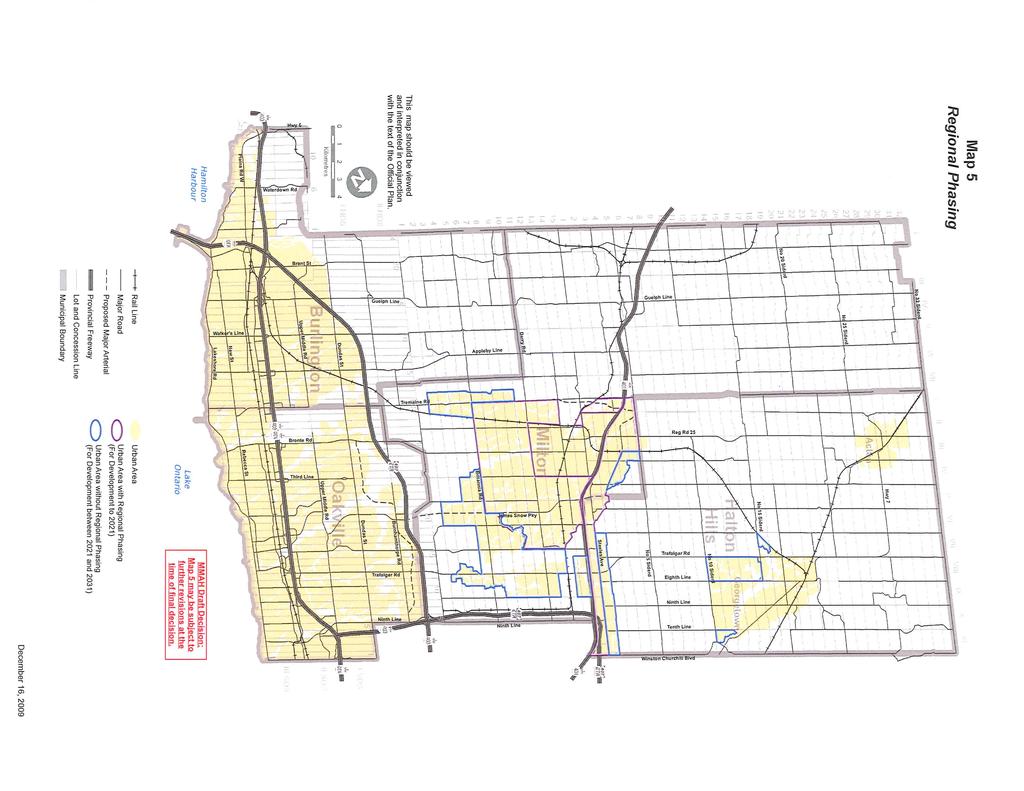
15 Map 1 Map 1 Map 1A Map 1C Map 1E Map 1F Map 3 Map 3 Map 3 Amend Map 1 by identifying through symbol, the Milton GO Station, Oakville GO Station, Downtown Burlington Urban Growth Centre, and Burlington GO Station as Mobility Hubs, and add Mobility Hub to the map legend. Amend Map 1 to identify the proposed Acton GO Station through symbol. Amend Map 1A to depict the Greenbelt Natural Heritage System as an overlay on the Protected Countryside. Further amend Map 1A to clearly show the PBWP areas. Map 1C is deleted in its entirety and remaining maps are renumbered accordingly and references throughout the Official Plan are updated. The prime agricultural areas are to be revised to appropriately reflect contiguous prime agricultural and rural areas. The Identified Mineral Resource Area is to be revised to remove areas which have been extracted and no longer represent areas of potential aggregate resource. Amend Map 3 to identify proposed provincial transportation corridors, including the GTA West and Niagara to GTA corridors. Amend Map 3 by identifying through symbol, the Milton GO Station, Oakville GO Station, Downtown Burlington Urban Growth Centre, and Burlington GO Station as Mobility Hubs, and add Mobility Hub to the map legend. Amend Map 3, by identifying by dashed line, the proposed commuter rail corridor from Georgetown to Acton, by adding Proposed Commuter Rail Corridor to the legend, and by adding the proposed Acton GO Station through symbol. Matters not yet addressed in this Draft Decision: Agricultural Rural Area Further modifications to ROPA 38, within this Section and other, shall be made to address rural settlements, the application of MDS, prime agricultural areas, and Greenbelt Plan implementation. Greenbelt Plan Policy Area Further modifications to ROPA 38, within this Section and others, shall be made to address Greenbelt Plan implementation, such as: lower tier implementation policy; no redesignation of prime agricultural areas for non-agricultural uses within the Protected Countryside; existing uses; refinement of natural heritage system; protection of additional key natural heritage features; explanation of VPZ and its application; minor rounding out of Hamlets; recreational uses; infrastructure; and mineral aggregate operations. Oct Draft - for discussion only 11/12
16 Map 1 Map 1 Mineral Aggregate Resources Further modifications to ROPA 38 shall be made to ensure consistency with the PPS and conformity with the Greenbelt Plan. Regional Natural Heritage System: Further modifications to ROPA 38, within this Section and others, shall be made to address the protection of key features. Employment Area/Urban Area shown on Map 1 in red cross-hatching, comprised of land in Lot 1, Concession X and XI (north side of Steeles Avenue between Ninth Line and Winston Churchill Boulevard), and similarly for the same urban area designated on all subsequent maps. Areas of this map are subject to further modification with respect to Greenbelt Plan conformity, including the identification of the Greenbelt and Natural Heritage System boundaries. Oct Draft - for discussion only 12/12
17
18
19
20
21
22
23
24
25
26
27
28
Sustainable Growth. Sustainable Growth
 2 Sustainable Growth Sustainable Growth SUSTAINABLE GROWTH 2.1 COMMUNITY VISION... 2-5 2.2 THE CITY SYSTEM... 2-7 2.2.1 AREAS... 2-7 2.2.2 CITY-WIDE SYSTEMS... 2-8 2.2.3 PROVINCIAL PLAN BOUNDARIES AND
The protection of the agricultural resources of the Province;
 PART II INTRODUCTION An Official Plan is a policy document, which is intended to serve as the basis for making land use decisions and managing change in any municipality in Ontario. According to the Planning
9 CITY OF VAUGHAN OFFICIAL PLAN AMENDMENT NO BOCA EAST INVESTMENTS LIMITED
 9 CITY OF VAUGHAN OFFICIAL PLAN AMENDMENT NO. 631 - BOCA EAST INVESTMENTS LIMITED The Planning and Economic Development Committee recommends the adoption of the recommendations contained in the following
TOWN OF HALTON HILLS OFFICIAL PLAN AMENDMENT 10 PROPOSED MODIFICATIONS. Premier Gateway Employment Lands Re-Phasing. to implement
 TOWN OF HALTON HILLS OFFICIAL PLAN AMENDMENT 0 PROPOSED MODIFICATIONS Premier Gateway Employment Lands Re-Phasing to implement Halton Peel Boundary Area Transportation Study/ GTA West Corridor Protection
PART IV - LAND USE POLICIES - RURAL PLANNING AREA
 PART IV - LAND USE POLICIES - RURAL PLANNING AREA 1.0 INTRODUCTION *D9 This part of the Plan presents the principles, objectives and policies for the land use designations identified on the Settlement
Employment and Commercial Review Analysis of Policy Directions
 Employment and Commercial Review Analysis of Policy Directions Appendix A The following analysis is town staff s response to the policy directions provided by the consultants who prepared the Employment
TOWN OF HALTON HILLS OFFICIAL PLAN AMENDMENT 10 PROPOSED MODIFICATIONS. Premier Gateway Employment Lands Re-Phasing. to implement
 TOWN OF HALTON HILLS OFFICIAL PLAN AMENDMENT 0 PROPOSED MODIFICATIONS Premier Gateway Employment Lands Re-Phasing to implement Halton Peel Boundary Area Transportation Study/ GTA West Corridor Protection
Summary of Changes for the Comprehensive Draft Proposed Official Plan Amendment
 Summary of Changes for the Comprehensive Draft Proposed Official Plan Amendment Note: Due to the broad scope of the Official Plan Review, this list is not exhaustive of the extent of changes in the comprehensive
The lands identified as Residential Areas on Schedule A1, Urban Structure, represent the areas that provide for stable residential communities.
 Livable Oakville Part D: Land Use Designations and Policies 11. RESIDENTIAL 11.1 General The lands identified as Residential Areas on Schedule A1, Urban Structure, represent the areas that provide for
TERRESTRIAL NATURAL HERITAGE SYSTEM STRATEGY APPENDIX F: MODEL POLICIES FOR THE IMPLEMENTATION OF THE TARGET TERRESTRIAL NATURAL HERITAGE SYSTEM
 TERRESTRIAL NATURAL HERITAGE SYSTEM STRATEGY APPENDIX F: MODEL POLICIES FOR THE IMPLEMENTATION OF THE TARGET TERRESTRIAL NATURAL HERITAGE SYSTEM C H A P T E R 1 M O D E L P O L I C I E S F O R I M P L
1 Introduction. Chapter. In this chapter:
 Chapter 1 Introduction In this chapter: 1.1 A Snapshot of the Region 1.2 Towards a Sustainable Region 1.3 The Provincial Context 1.4 Purpose and Organization The Regional Municipality of York Official
This page has been intentionally left blank.
 This page has been intentionally left blank. Chapter 3 3-2 3. Employment 3.A Niagara Economic Gateway 3.A.1 General The Niagara Economic Gateway comprises: a) The Gateway Economic Zone which includes all
6 Growth Management Challenges and Opportunities
 6 Growth Management Challenges and Opportunities The Town has established a goal of attaining a 50% participation rate with respect to employment opportunities versus residential population. The Town s
THE REGIONAL MUNICIPALITY OF PEEL BY-LAW NUMBER
 - 1 - THE REGIONAL MUNICIPALITY OF PEEL BY-LAW NUMBER 34-2010 A by-law to adopt Regional Official Plan Amendment Number 24 to the Region of Peel Official Plan in order to amend policies related to Growth
A Growing Community Rural Settlement Areas
 Town of Huntsville Official Plan Review - POLICY BACKGROUND PAPER A Growing Community Rural Settlement Areas BACKGROUND: In addition to the fully municipally-serviced Urban Settlement Area and the Hidden
Figure 1- Site Plan Concept
 Figure 1- Site Plan Concept Parking will be provided underground on three levels at rate of 1.0 space/ unit; this rate includes all visitors parking. MMM Group has prepared a parking assessment (April,
Peel Region. Greenbelt Plan Conformity. Plan Review. Background & Approach
 Peel Region Plan Review Background & Approach Greenbelt Plan Conformity November 2008 Page 2 of 13 2 COMMENT SHEET Region of Peel Greenbelt Plan Policy Review This comment sheet is to be used to provide
a) recognize agriculture as the primary activity and land use; b) maintain and preserve the agricultural resource base of the Town;
 recognize agriculture as the primary activity and land use; b) maintain and preserve the agricultural resource base of the Town;") PA RT E E1 AGRICULTURAL AREA E1.1 OBJECTIVES It is the objective of this designation to: a) recognize agriculture as the primary activity and land use; b) maintain and preserve the agricultural resource
PA RT E E1 AGRICULTURAL AREA E1.1 OBJECTIVES It is the objective of this designation to: a) recognize agriculture as the primary activity and land use; b) maintain and preserve the agricultural resource
THE STRUCTURE OF THE PLAN...
 TABLE OF CONTENTS THE STRUCTURE OF THE PLAN... 1 A1 THE COMMUNITY VISION... 3 A2 GOALS AND OBJECTIVES... 3 A2.1 THE NATURAL ENVIRONMENT... 3 A2.1.1 Goal... 3 A2.1.2 Objectives... 3 A2.2 GROWTH AND SETTLEMENT...
AMENDMENT NO. 30 TO THE OFFICIAL PLAN OF THE TOWN OF MILTON
 AMENDMENT NO. 30 TO THE OFFICIAL PLAN OF THE TOWN OF MILTON Subject: Boyne Survey Secondary Plan and Related Official Plan Amendments The following text and schedules constitute Amendment No. 30 to the
THE CORPORATION OF THE TOWN OF OAKVILLE BY-LAW NUMBER
 THE CORPORATION OF THE TOWN OF OAKVILLE BY-LAW NUMBER 2017-120 A by-law to adopt an amendment to the Livable Oakville Plan, Official Plan Amendment Number 20 (Downtown Oakville Growth Area) WHEREAS the
Environment and Sustainability. Environment and Sustainability
 4 Environment and Sustainability Environment and Sustainability ENVIRONMENT AND SUSTAINABILITY 4.1 CLIMATE CHANGE AND AIR QUALITY... 4-5 4.1.1 OBJECTIVES... 4-6 4.1.2 POLICIES... 4-6 4.2 NATURAL HERITAGE
Official Plan Review
 Official Plan Review Summary Report - The Built Environment August 2014 Part 1: Introduction Planning for a healthy, prosperous and sustainable community is an important goal for our municipality. From
11.4 Highway 400 North Employment Lands Secondary Plan APPROVED BY THE ONTARIO MUNICIPAL BOARD ON NOVEMBER 21, 2011
 11.4 Highway 400 North Employment Lands Secondary Plan APPROVED BY THE ONTARIO MUNICIPAL BOARD ON NOVEMBER 21, 2011 11.4.1 General 11.4.1.1. as approved by the Ontario Municipal Board on November 21, 2011,
THE CITY OF VAUGHAN BY-LAW BY-LAW NUMBER A By-law to adopt Amendment Number 1 to the Official Plan of the Vaughan Planning Area.
 THE CITY OF VAUGHAN BY-LAW BY-LAW NUMBER 015-2014 A By-law to adopt Amendment Number 1 to the Official Plan of the Vaughan Planning Area. NOW THEREFORE the Council of the Corporation of the City of Vaughan
2. Shaping Waterloo Region s Urban Communities
 2. Much of the region s growth over the past several decades has occurred in suburban areas that separated where people live from where they work and shop. This pattern of growth has increased the need
AMENDMENT NO. 2 TO THE TRENT HILLS OFFICIAL PLAN
 The Municipality of Trent Hills Official Plan AMENDMENT NO. 2 TO THE TRENT HILLS OFFICIAL PLAN Adopted by Council on Approved by the Ministry of Municipal Affairs and Housing on Version Date: November
THE CORPORATION OF THE TOWN OF OAKVILLE BY-LAW NUMBER
 THE CORPORATION OF THE TOWN OF OAKVILLE BY-LAW NUMBER 20012-08530 A by-law to adopt an amendment to the Official Plan of the Oakville Planning Area (Official Plan Amendment 198) Land North of Dundas Street.
CITY OF LANGLEY OFFICIAL COMMUNITY PLAN BYLAW, 2005, NO APPENDIX II - REGIONAL CONTEXT MAP
 CITY OF LANGLEY OFFICIAL COMMUNITY PLAN BYLAW, 2005, NO. 2600 APPENDIX II - REGIONAL CONTEXT MAP ± Legend Agricultural Mixed Employment Industrial Conservation & Recreation Regional City Centre Urban Containment
and services The protection and conservation of environmentally significant and sensitive natural heritage features and functions.
 6. Land Use 6.0 Preamble A healthy and livable city is one in which people can enjoy a vibrant economy and a sustainable healthy environment in safe, caring and diverse neighbourhoods. In order to ensure
THE CORPORATION OF THE CITY OF WINDSOR Office of the City Solicitor Planning Department
 THE CORPORATION OF THE CITY OF WINDSOR Office of the City Solicitor Planning Department REPORT TO THE CITY OF WINDSOR PLANNING ADVISORY COMMITTEE DATE OF REPORT: August 19, 2010 SUBJECT: Official Plan
CONTENTS 8.0 LAND USE 8.1 GENERAL LAND USE 8.2 RESIDENTIAL 8.3 MIXED USE 8.4 COMMERCIAL 8.5 EMPLOYMENT LANDS
 8-2 Land Use 8.0 LAND USE CONTENTS 8.1 GENERAL LAND USE 8.1.1 Uses provided for in all Land Use Designations 8.1.2 Uses prohibited in Hazardous Lands, Hazardous Sites and Special Policy Areas 8.1.3 Uses
The Corporation of the Town of Milton
 Report To: From: Council Barbara Koopmans, Commissioner, Planning and Development Date: May 7, 2018 Report No: Subject: Making it Possible Positioning the Town s Strategy for Growth and Economic Development
Plan Modification to Chapter B2 of the Auckland Unitary Plan(AUP) Operative in part (15 November 2016)
 Operative in part (15 November 2016)") UNITARY PLAN UPDATE REQUEST MEMORANDUM TO FROM Phill Reid Linley Wilkinson DATE 25 September 2018 SUBJECT Plan Modification to Chapter B2 of the Auckland Unitary Plan(AUP) Operative in part (15 November
UNITARY PLAN UPDATE REQUEST MEMORANDUM TO FROM Phill Reid Linley Wilkinson DATE 25 September 2018 SUBJECT Plan Modification to Chapter B2 of the Auckland Unitary Plan(AUP) Operative in part (15 November
6 PORT SYDNEY SETTLEMENT AREA
 Section 6 Port Sydney Page 61 6 PORT SYDNEY SETTLEMENT AREA 6.1 Basis and Principles Village of Port Sydney Waterfront Community Existing Services 6.1.1 Port Sydney is an historic settlement that has developed
NEW REGIONAL OFFICIAL PLAN HIGH LEVEL PROCESS & FRAMEWORK
 NEW REGIONAL OFFICIAL PLAN HIGH LEVEL PROCESS & FRAMEWORK Why A New Official Plan Originally the role of Regionally Planning and content of Regional Official Plan (1970s) primarily focused on protecting
BRAMPTON FLOWERTOWN SECONDARY PLAN Area 6
 BRAMPTON FLOWERTOWN SECONDARY PLAN Area 6 October 2018 EXPLANATORY NOTES Brampton Flowertown Secondary Plan Area 6 General i. Secondary plans form part of the Official Plan and are to be read in conjunction
Township of Adjala-Tosorontio Official Plan Review. Natural Heritage
 Township of Adjala-Tosorontio Official Plan Review 13 Natural Heritage Introduction What is an Official Plan? An official plan is a municipal policy document which sets out the community s vision and strategies
13. VANDORF-PRESTON LAKE SECONDARY PLAN 13.1 INTRODUCTION
 13. VANDORF-PRESTON LAKE SECONDARY PLAN 13.1.1 Purpose 13.1 INTRODUCTION The Vandorf-Preston Lake Secondary Plan establishes the principles, objectives and general policies, as well as specific strategies
OFFICIAL PLAN FOR THE TOWN OF NEW TECUMSETH
 OFFICIAL PLAN FOR THE TOWN OF NEW TECUMSETH Approved by Simcoe County- March 10, 2010 TABLE OF CONTENTS PAGE# 1.0 TITLE AND COMPONENTS... 5 2.0 INTRODUCTION... 6 2.1 Purpose... 6 2.2 Organization of the
11.4 Highway 400 North Employment Lands Secondary Plan
 11.4 Highway 400 North Employment Lands Secondary Plan APPROVED BY THE ONTARIO MUNICIPAL BOARD ON NOVEMBER 21, 2011 11.4.1 General 11.4.1.1. The following policies and Schedules A - I form Official Plan
ONTARIO MUNICIPAL BOARD
 PL 120483 ONTARIO MUNICIPAL BOARD Applicant/Appellant: 2124123 Ontario Limited Subject: OPA, Rezoning and Draft Plan of Subdivision Municipal Address: 3940 Highway 7 East Municipality: City of Markham
Master Environmental Servicing Plan & Secondary Plan
 1 East Side Lands Stage 2 Master Environmental Servicing Plan & Secondary Plan Public Consultation Centre #4 March 20, 2018 Welcome! Today s Agenda Please sign in at the registration table. 6:00 pm 6:30
Tāhuhu whakaruruhau ā-taone The sheltering ridge pole
 B2. Tāhuhu whakaruruhau ā-taone - Urban growth and form B2.1. Issues Tāhuhu whakaruruhau ā-taone The sheltering ridge pole Auckland s growing population increases demand for housing, employment, business,
SCHEDULE 'A' TO BY-LAW as Amended by AMENDMENT NO. 90 TO THE WHITBY OFFICIAL PLAN
 SCHEDULE 'A' TO BY-LAW 6413-10 as Amended by 6553-11 AMENDMENT NO. 90 TO THE WHITBY OFFICIAL PLAN SECTION A: GROWTH PLAN CONFORMITY PURPOSE: LOCATION: BASIS: The purpose of this Amendment is to: conform
PORT WHITBY COMMUNITY
 PORT WHITBY COMMUNITY SECONDARY PLAN UPDATE COMMUNITY IMPROVEMENT PLAN URBAN DESIGN GUIDELINES September 2015 DRAFT PROPOSED AMENDMENT NUMBER # to the Whitby Official Plan PURPOSE: The intent of this Amendment
Growing Community Urban Settlement Area and Hidden Valley Settlement Area
 Town of Huntsville Official Plan Review - POLICY BACKGROUND PAPER Growing Community Urban Settlement Area and Hidden Valley Settlement Area BACKGROUND: Through the Provincial Policy Statement (PPS), the
SUBJECT: New Official Plan Review: Rural, Natural Heritage and Sustainability Policy Directions
 Page 1 of Report PB-83-16 SUBJECT: New Official Plan Review: Rural, Natural Heritage and Sustainability Policy Directions TO: FROM: Committee of the Whole Planning and Building Department Report Number:
Planning Justification Report. Milton Meadows Properties Ltd. Milton Meadows South IN SUPPORT OF ZONING BY-LAW AMENDMENT & DRAFT PLAN OF SUBDIVISION
 Planning Justification Report Milton Meadows Properties Ltd. Milton Meadows South IN SUPPORT OF ZONING BY-LAW AMENDMENT & DRAFT PLAN OF SUBDIVISION For Part of Lot 3, Concession 1 Town of Milton HUMPHRIES
CONTENTS 2.0 A FRAMEWORK FOR SUSTAINABLE GROWTH 2.1 MANAGING SUSTAINABLE GROWTH THE VISION TO GOALS AND OBJECTIVES 2.3 MARKHAM STRUCTURE
 2 A Framework for Sustainable Growth 2.0 A FRAMEWORK FOR SUSTAINABLE GROWTH CONTENTS 2.1 MANAGING SUSTAINABLE GROWTH THE VISION TO 2031 2.2 GOALS AND OBJECTIVES 2.2.1 Protecting the Natural Environment
CONSULTING SERVICES FOR THE WHITEBELT VISIONING EXERCISE ADDENDUM TO THE GTA WEST LAND USE STUDY WORK PROGRAM
 CONSULTING SERVICES FOR THE WHITEBELT VISIONING EXERCISE ADDENDUM TO THE GTA WEST LAND USE STUDY 1. Introduction WORK PROGRAM The Town of Caledon is a large, local municipality located in the Greater Toronto
SUBJECT: Revised proposed new official plan recommended for adoption
 Page 1 of Report PB-04-18 SUBJECT: Revised proposed new official plan recommended for adoption TO: FROM: Planning and Development Committee Department of City Building Report Number: PB-04-18 Wards Affected:
2.0 A FRAMEWORK FOR SUSTAINABLE GROWTH CONTENTS
 2-2 A Framework for Sustainable Growth 2.0 A FRAMEWORK FOR SUSTAINABLE GROWTH CONTENTS 2.1 MANAGING SUSTAINABLE GROWTH THE VISION TO 2031 2.2 GOALS AND OBJECTIVES 2.2.1 Protecting the Natural Environment
PLANNING RATIONALE FOR ZONING BY-LAW AMENDMENT MINTO COMMUNITIES INC. ARCADIA RESIDENTIAL STAGES 3 & 4 ARCADIA COMMERCIAL STAGE 2 CITY OF OTTAWA
 PLANNING RATIONALE FOR ZONING BY-LAW AMENDMENT MINTO COMMUNITIES INC. ARCADIA RESIDENTIAL STAGES 3 & 4 ARCADIA COMMERCIAL STAGE 2 CITY OF OTTAWA Prepared for: MINTO COMMUNITIES INC. 180 Kent Street, Suite
Background Summary Report
 Background Summary Report May 2014 Submitted by Macaulay Shiomi Howson Ltd. In association with AMEC MMM Group Brook McIlroy Inc. Hemson Consulting Ltd. Table of Contents 1. Introduction... 1 2. Why is
1120 Haist Street - Pelham Arena Community Co-Design Recommendation Report Haist Street - Pelham Arena Community Co-Design Recommendation Report
 1120 Haist Street - Pelham Arena Community Co-Design Executive Summary: In May, 2017 the Town retained the services of The Planning Partnership to undertake a community design charrette process to determine
THE COMMUNITY VISION A - 1
 PA RT A A1 THE COMMUNITY VISION The primary purpose of the Official Plan is to provide the basis for managing growth that will support and emphasize the Town s unique character, diversity, civic identity,
6 AMENDMENT NO. 637 TO THE VAUGHAN OFFICIAL PLAN (VAUGHAN 400 NORTH EMPLOYMENT AREA SECONDARY PLAN)
") Report No. 3 of the Planning and Economic Development Committee Regional Council Meeting of March 24, 2011 6 AMENDMENT NO. 637 TO THE VAUGHAN OFFICIAL PLAN (VAUGHAN 400 NORTH EMPLOYMENT AREA SECONDARY
Report No. 3 of the Planning and Economic Development Committee Regional Council Meeting of March 24, 2011 6 AMENDMENT NO. 637 TO THE VAUGHAN OFFICIAL PLAN (VAUGHAN 400 NORTH EMPLOYMENT AREA SECONDARY
OFFICIAL PLAN of the TOWN of BRADFORD WEST GWILLIMBURY Adopted February 15, 2000
 OFFICIAL PLAN of the TOWN of BRADFORD WEST GWILLIMBURY Adopted February 15, 2000 OFFICE CONSOLIDATION (Consolidated to October 1, 2002) J. Ross Raymond & Associates Ltd Gravenhurst, Ontario Building Community
Proposed UHAUL Burlington Interior Self Storage & Vehicle Rental Facility
 Proposed UHAUL Burlington Interior Self Storage & Vehicle Rental Facility AMERCO Real Estate / UHAUL Co. 3267 Mainway Rd. Burlington, Ontario April, 2018 Prepared By: Strategy4 Inc. 1. Introduction: The
AMENDMENT NO. 41 TO THE OFFICIAL PLAN FOR THE TOWN OF MONO
 AMENDMENT NO. 41 TO THE OFFICIAL PLAN FOR THE TOWN OF MONO This Amendment to the Official Plan for the Town of Mono, which has been adopted by the Corporation of the Town of Mono, is hereby approved in
HEMSON C o n s u l t i n g L t d.
 INVENTORY & ASSESSMENT OF INTENSIFICATION OPPORTUNITIES City of Brampton Discussion i Paper for Public Review C o n s u l t i n g L t d. November 2008 EXECUTIVE SUMMARY This report is one of the key background
Land Use Policies. North Aldershot Area Land Use Policies. 10 North Aldershot Area
 Land Use Policies North Aldershot Area Land Use Policies 10 North Aldershot Area This page has been left intentionally blank LAND USE POLICIES NORTH ALDERSHOT 10.1 SECTORS... 10-5 10.1.1 CENTRAL SECTOR...
TOWN OF BRUDERHEIM Report to the capital region board
 TOWN OF BRUDERHEIM Report to the capital region board Introduction to the Town of Bruderheim Municipal Development Plan amendment and Relation to the CRB Evaluation Criteria 02 march 2017 1 Introduction
11. BALLANTRAE-MUSSELMAN LAKE AND ENVIRONS SECONDARY PLAN
 11. BALLANTRAE-MUSSELMAN LAKE AND ENVIRONS SECONDARY PLAN 11.1 PURPOSE The Ballantrae-Musselman Lake and Environs Secondary Plan Area includes two small existing settlement areas, Ballantrae and Musselman
Mark-up of the effect of the proposed Bronte Village Growth Area OPA No.18 on the text of section 24, Bronte Village, of the Livable Oakville Plan
 Mark-up of the effect of the proposed Bronte Village Growth Area OPA No.18 on the text of section 24, Bronte Village, of the Livable Oakville Plan Notes: This document is provided for information purposes
NOTE: PLEASE REFER TO CITY PLAN FOR ADDITIONAL CITY-WIDE POLICIES WHICH APPLY TO THIS DISTRICT.
 NOTE: THE POLICIES IN THIS DOCUMENT ARE SPECIFIC TO THE SHERIDAN RESIDENTIAL PLANNING DISTRICT OF, AND MUST BE READ IN CONJUNCTION WITH ALL THE POLICIES OF CITY PLAN PLEASE REFER TO FOR ADDITIONAL CITY-WIDE
Master Environmental Servicing Plan & Secondary Plan
 East Side Lands Stage 2 1 Master Environmental Servicing Plan & Secondary Plan Public Information Centre #1 June 16, 2016 Welcome! Today s Agenda Please sign in at the front desk. 5:30 pm 6:30 pm: Open
Planning Primer Legislative Background, Policy Documents and Development Review Processes. Presented by: Planning Services Date: April 6, 2017
 Planning Primer Legislative Background, Policy Documents and Development Review Processes Presented by: Planning Services Date: April 6, 2017 Agenda Legislative Background 7:30 to 8:00 pm Questions 8:00
Draft Urban Hamilton Official Plan. Amendment No. XX
 1 of 75 The following text, together with: Draft Appendix A Appendix B Volume 1, Schedule E-1 Urban Land Use Designations Appendix C Volume 1, Appendix A Parks Classification Map Appendix D Volume 1, Appendix
Trafalgar Road Corridor Planning Study Open House
 Trafalgar Road Corridor Planning Study Open House June 24, 2013 6:30-8:30 p.m. Oakville & Trafalgar Rooms Overview The Livable Oakville Plan identifies the lands along Trafalgar Road, between the QEW and
DRAFT. & Secondary Plan Study. East Side Lands- Stage 2. Planning Rationale Report
 East Side Lands- Stage 2 Master Environmental SERVICING Plan & Secondary Plan Study Planning Rationale Report Draft April 24, 2018 QUALITY MANAGEMENT Issue/Revision First Issue Revision 1 Revision 2 Remarks
TOWN OF HALTON HILLS OFFICIAL PLAN
 TOWN OF HALTON HILLS OFFICIAL PLAN (Consolidated May 2008) Adoption Date: September 18, 2006 This office consolidation of the Town of Halton Hills Official Plan has been provided for convenience only.
3-2 Environmental Systems
 3-2 Environmental Systems 3.0 ENVIRONMENTAL SYSTEMS CONTENTS 3.1 GREENWAY SYSTEM 3.1.1 General Policies 3.1.2 Natural Heritage Network 3.1.3 Natural Heritage Network Enhancement Lands 3.1.4 Rouge Watershed
Draft ROPA 43 - HPBATS/GTA West Corridor Protection
 Draft ROPA 4 - HPBATS/GTA West Corridor Protection Overview Purpose The purpose of Regional Official Plan Amendment (ROPA) No. 4 is to: Implement a corridor protection area to protect for the planned corridor
MAYFIELD WEST SECONDARY PLAN PHASE 2
 MAYFIELD WEST SECONDARY PLAN PHASE 2 Public Open House #3 February 25, 2010 Draft Preferred Land Use Scenario TOWN OF CALEDON PLANNING & DEVELOPMENT DEPARTMENT Open House Agenda TOWN OF CALEDON 1. Welcome
County of Haliburton. Effective March 14, 2006
 County of Haliburton Effective March 14, 2006 Council Adopted Update under Section 26 of the Planning Act : February 17, 2010 Ministerial Approval: October 7, 2010, Date Effective: November 5, 2010 County
MAYFIELD WEST SECONDARY PLAN PHASE 2
 MAYFIELD WEST SECONDARY PLAN PHASE 2 Council Information Workshop February 16, 2010 Draft Preferred Land Use Plan TOWN OF CALEDON PLANNING & DEVELOPMENT DEPARTMENT Workshop Agenda TOWN OF CALEDON 1. Welcome
Official Plan Review: Draft Built Form Policies
 PG.30.1 REPORT FOR ACTION Official Plan Review: Draft Built Form Policies Date: May 15, 2018 To: Planning and Growth Management Committee From: Chief Planner and Executive Director, City Planning Division
TOWN OF SAUGEEN SHORES OFFICIAL PLAN
 TOWN OF SAUGEEN SHORES OFFICIAL PLAN Adopted by Council: December 10, 2012 Approved by County of Bruce: March 26, 2014 (Office Consolidation September 2014) Town of Saugeen Shores 1 Table of Contents Saugeen
OFFICE CONSOLIDATION SECONDARY PLAN AREA 22 THE BRAMALEA SOUTH INDUSTRIAL SECONDARY PLAN
 OFFICE CONSOLIDATION SECONDARY PLAN AREA 22 THE BRAMALEA SOUTH INDUSTRIAL SECONDARY PLAN November 2010 EXPLANATORY NOTES (Secondary Plan Area 22) General (pertaining to all secondary plan office consolidations)
1.0 PLANNING MARKHAM S FUTURE CONTENTS
 1-1 Planning Markham s Future 1.0 PLANNING MARKHAM S FUTURE CONTENTS 1.1 THE PURPOSE OF THE OFFICIAL PLAN 1.2 THE MARKHAM CONTEXT 1.3 THE REGULATORY CONTEXT 1.3.1 Province of Ontario 1.3.2 York Region
PUBLIC OPEN HOUSE HURONTARIO-MAIN CORRIDOR SECONDARY PLAN
 PUBLIC OPEN HOUSE HURONTARIO-MAIN CORRIDOR SECONDARY PLAN Tuesday, February 28, 2012 6pm 9pm 1 st Floor Atrium, City Hall 2 Wellington Street West, Brampton 1 POLICY FRAMEWORK The 2006 Provincial Growth
OFFICIAL PLAN UPDATE PLANNING ACT SECTION 26
 OFFICIAL PLAN UPDATE PLANNING ACT SECTION 26 Stakeholders Meeting November 20, 2017 EcoVue Consulting Services Inc. 311 George Street North Suite 200 Peterborough, Ontario K9J 3H3 T 705.876.8340 F 705.742.8343
2136 & 2148 Trafalgar Road Town of Oakville Region of Halton
 PLANNING JUSTIFICATION REPORT 2136 & 2148 Trafalgar Road Town of Oakville Region of Halton Zoning By-Law Amendment Application 2500674 Ontario Inc. November 2016 Table of Contents Page 1.0 Location/Summary
SUBJECT: GO Station Mobility Hubs Preferred Concepts: Aldershot GO, Burlington GO and Appleby GO. Planning and Development Committee - Public Meeting
 Page 1 of Report PB-76-17 SUBJECT: GO Station Mobility Hubs Preferred Concepts: Aldershot GO, Burlington GO and Appleby GO TO: FROM: Planning and Development Committee - Public Meeting Planning and Building
Complete Neighbourhood Guidelines Review Tool
 Complete Neighbourhood Guidelines Review Tool Prepared By: City of Regina Planning Department October 2014 Page 1 of 14 Community Development Review Checklist for Secondary Plans and Concept Plans The
THAT the attached Terms of Reference for the Thornhill Centre Street Study be approved.
 COMMITTEE OF THE WHOLE AUGUST 18, 2003 THORNHILL CENTRE STREET STUDY PLANNING FILE: 15.92 Recommendation The Commissioner of Planning recommends: THAT the attached Terms of Reference for the Thornhill
The West Vaughan Employment Area Secondary Plan Policies
 Part 2: The West Vaughan Employment Area Secondary Plan Policies 2.1 General Policies It is the policy of Council: 2.1.1. That the West Vaughan Employment Area (the WVEA), identified on Schedule 1, will
CITY OF BARRIE OFFICIAL PLAN (APRIL 2010)
") CITY OF BARRIE OFFICIAL PLAN (APRIL 2010) On April 23, 2010, The Ministry of Municipal Affairs and Housing (MMAH) approved a new Official Plan for the City of Barrie. The MMAH modifications are referenced
CITY OF BARRIE OFFICIAL PLAN (APRIL 2010) On April 23, 2010, The Ministry of Municipal Affairs and Housing (MMAH) approved a new Official Plan for the City of Barrie. The MMAH modifications are referenced
2 STATUTORY PUBLIC MEETING AND INFORMATION REPORT FOR PUBLIC MEETING ON AMENDMENT NO. 62 TO THE YORK REGION OFFICIAL PLAN
 2 STATUTORY PUBLIC MEETING AND INFORMATION REPORT FOR PUBLIC MEETING ON AMENDMENT NO. 62 TO THE YORK REGION OFFICIAL PLAN Pursuant to Section 17(15) of the Planning Act, as amended, the Regional Planning
SECTION E. Realizing the Plan
 SECTION E Realizing the Plan 60 DESIGN REGINA - OFFICIAL COMMUNITY PLAN SECTION E Realizing the Plan Design Regina has been an ambitious plan-making exercise, with a high level of community, stakeholder,
6 RURAL RESIDENTIAL. 6.1 Rural Use. Rural Use (RU) Goals and Objectives. Policy Goal
 Goals and Objectives. Policy Goal") 6 RURAL RESIDENTIAL The vast majority of East Hants 466,426 acres are considered rural in nature and are characterized by a great diversity of uses. Because of this, land use policies in rural areas of
6 RURAL RESIDENTIAL The vast majority of East Hants 466,426 acres are considered rural in nature and are characterized by a great diversity of uses. Because of this, land use policies in rural areas of
178 Carruthers Properties Inc.
 178 Carruthers Properties Inc. Planning Rationale for 178 Carruthers Avenue Site Plan Control Application June 2014 Table of Contents 1.0 Introduction 2.0 Overview of Subject Property 3.0 Current Zoning
B R I E F A p p e n d i x A : F i g u r e s
 HALTON MUNICIPALITIES BRIEF: APPENDIX A 1 B R I E F A p p e n d i x A : F i g u r e s 2 0 1 6 Halton Municipalities Regional Municipality of Halton Corporation of the City of Burlington Corporation of
Table 8-4: Road Classification Local Roads, second table, of Chapter 8 Create a Multi-Modal City, be amended by adding the following:
 1 Port Street East Official Plan Amendment APPENDIX 3 Amendments to Mississauga Official Plan Table 8-4: Road Classification Local Roads, second table, of Chapter 8 Create a Multi-Modal City, be amended
The Regional Municipality of Halton. Chair and Members of the Planning and Public Works Committee
 The Regional Municipality of Halton Report To: From: Chair and Members of the Planning and Public Works Committee Art Zuidema, Commissioner, Legislative and Planning Services Date: October 4, 2017 Report
Niagara Region Official Plan. Table of Contents
 Niagara Region Official Plan Table of Contents This page has been intentionally left blank. Table of Contents ii Niagara Region Official Plan Niagara Region Official Plan - Table of Contents Chapter 1
Draft Amendment Provides details regarding ROPA 47 s purpose and effect. Related Processes Highlights other ongoing processes of note in the area
 An Amendment to Address a Shortfall of Employment Lands in the Town of Halton Hills Premier Gateway Employment Area Public nformation Centre Wednesday November 1, 2017 6:30p.m. - 8:30p.m. Hillcrest United
150 Eighth Street Zoning By-law Amendment Application Preliminary Report
 REPORT FOR ACTION 150 Eighth Street Zoning By-law Amendment Application Preliminary Report Date: March 27, 2019 To: Etobicoke York Community Council From: Director, Community Planning, Etobicoke York District