175 RICHMOND ROAD ZONING BY-LAW AMENDMENT PLANNING RATIONALE
|
|
|
- Warren Stokes
- 6 years ago
- Views:
Transcription


1 175 RICHMOND ROAD ZONING BY-LAW AMENDMENT PLANNING RATIONALE Prepared for: Prepared by: OCTOBER 2011
2 175 RICHMOND ROAD ZONING BY-LAW AMENDMENT PLANNING RATIONALE Prepared for: Claridge Homes Gladstone Avenue Ottawa, Ontario K2P 0Y6 Prepared by: FoTenn Consultants Inc. 223 McLeod Street Ottawa, Ontario K2P 0Z8 T F OCTOBER 2011
3 TABLE OF CONTENTS INTRODUCTION... 2 DEVELOPMENT PROPOSAL... 2 PLANNING APPLICATIONS... 7 BACKGROUND... 8 ROAD NETWORK & TRANSIT POLICY AND REGULATORY FRAMEWORK URBAN DESIGN GUIDELINES REGULATORY FRAMEWORK REQUESTED ZONING BY LAW AMENDMENT SUPPORTING STUDIES PLANNING CONSIDERATIONS APPENDIX A: PRELIMINARY SITE PLAN APPENDIX B: SUNSHADOWING STUDY... 41

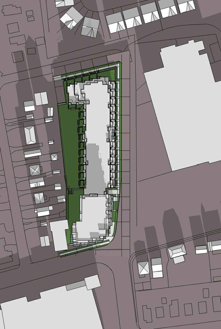
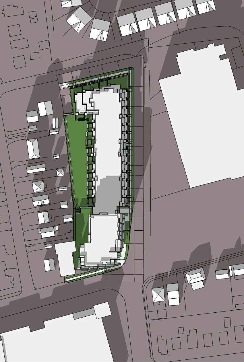
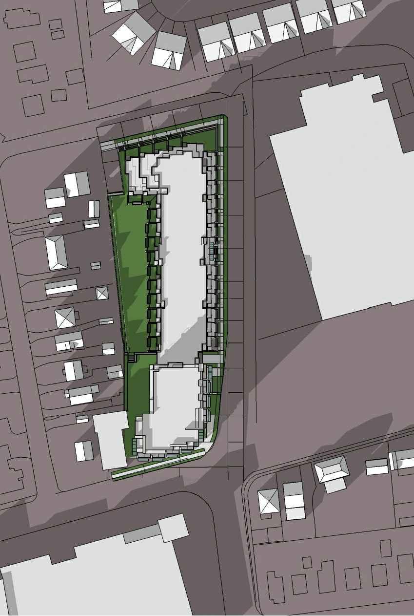
4 INTRODUCTION FoTenn Consultants Inc. has been retained by Claridge Homes to prepare a Planning Rationale in support of the Zoning By law Amendment and Site Plan Control Applications for the lands located at 175 Richmond Road. The intent of this report is to assess how the proposed development achieves and conforms to the objectives of the policy and regulatory framework applicable to the lands, and determine if the development is appropriate for the site and compatible with adjacent development and surrounding community. DEVELOPMENT PROPOSAL The proposed development consists of nine (9) storey mixed use building along Richmond Road, stepping down to a six (6) storeys residential building along Kirkwood Avenue. The building steps down further to four (4) storeys along Wilbur Avenue. The overall development consists of 241 residential units including 34 two level units (townhouses), 189 one bedroom units and 18 two bedroom units. The residential component of this development will have approximately 22,996 m 2 of gross floor area (which includes two levels of underground parking) and approximately 675 m 2 of retail commercial along Richmond Road. (Site plan has been enclosed under Appendix A). Building perspective along Kirkwood Avenue with Richmond Road to the south. 2
5 To respond to the extensive lot depth, the building massing has been broken down to create three (3) distinct built forms tailored to respond to a varying context moving across the site. The southern portion of the site fronts onto Richmond Road and will be developed with a nine storey mixed use building with ground floor commercial. The nine storey portion of the building will generally follow the typical traditional mainstreet pattern of development in terms of height, massing and building orientation. The building extends approximately 25 m back from the front lot line before being pulled back, allowing additional distance separation to the low profile residential community north of Richmond Road. This approach of replicating the typical lot fabric along Richmond Road allows for a tight and continuous urban fabric along the street without impacting on the low profile residential to the west of the site. The architecture and design of the nine (9) storey building incorporates elements typically associated with traditional mainstreet development. A step back at the second storey creates a strong podium base for the tower portion of the building while framing the street and visually reducing the building mass at grade. In addition to the podium, varying building materials will be incorporated throughout the building to break the building mass vertically and horizontally. The high percentage of glazing, particularly at grade, will contribute to an active, animated street frontage, while commercial uses at grade will contribute to the ongoing revitalization of this segment of Richmond Road. The building will restore the mainstreet fabric along a street previously characterized by parking lots, used car sales lots and other uses not reflective of its planned function. Moving north, the building steps down to six (6) storeys approximately 41 m from the front lot line along Richmond Road and will be separated from the nine (9) storey building at grade by a two storey high portico. The portico will allow a clear separation between the nine (9) and six (6) storey portion of the building while maintaining a continuous building frontage along Kirkwood Avenue. The portico will be a defining and recognizable architectural feature of the building. 3
 storey building is flanked by two (2) storey townhouses that continue north towards the Kirkwood and Wilbur Avenue intersection and wrap the corner.")
6 Building perspective along Wilbur Avenue looking towards Richmond Road to the south. The six (6) storey portion of the building will link to the nine (9) storey portion at the third (3) storey. Further north and beyond the portico, the six (6) storey building is flanked by two (2) storey townhouses that continue north towards the Kirkwood and Wilbur Avenue intersection and wrap the corner. The building will step back at the third storey, above the towns, with floors three (3) through six (6) accommodating condominium apartments. The mass of the six (6) storey building will be broken down vertically and horizontally with various architectural elements. The proposal incorporates the use of the two (2) storey townhouses along the entire building creating a horizontal separation while giving the development a low profile appearance at grade. Floors three (3) through six (6) will be setback from the edge of the townhouses further reducing the building mass at grade and ensuring light and air reach the sidewalk and the oversized residential patios proposed on the third floor. The use of varying building materials and colours will break down the massing vertically. Since the site benefits from three (3) street frontages, all three sides of the building will be designed to maintain an active street front. Again, the Kirkwood Avenue frontage will benefit from the two storey townhouses that front directly onto the street and have their front doors along Kirkwood. The two storey towns will wrap the corner and continue along Wilbur Avenue incorporating numerous direct pedestrian entrances along the street front. 4

7 In addition to responding to three (3) street frontages, the building design takes into consideration the shared property line with the low rise residential community to the west. The entire development with the exception of a portion of the building along Richmond Road has been considerably setback from the westerly property line providing a generous distance separation between the single detached dwellings along Clifton Street and this development. The distance separation ranges from 1.0 m where the site abuts the adjacent commercial lot along Richmond Road, gradually increasing to 15 m for the majority of the building. The area between the building and the shared property line will be landscaped and provide passive amenity space for the future residents of this development. The landscaped upper and lower decks will be accessible from Kirkwood Avenue via the two storey portico and consist of a combination of soft and hard landscaping. Perspective at grade along Kirkwood Avenue. The building massing and height have been distributed across the site in a way that minimizes impact on the adjacent residential community to the west. The tallest building at nine (9) storeys has been situated along Richmond Road where it shares a property line with the commercially zoned property assigned a maximum building height of 15 m or approximately 5 storeys. The building then steps down to 6 storeys and has been setback approximately 15 m from the shared property line. In addition, the building mass has been carefully sculpted with additional step backs at the 3 rd and 4 th and again at the 5 th and 6 th storeys along the interior property line. 5

8 The proposed development will be served by two levels of underground parking containing approximately 304 parking spaces. The parking will serve tenants, visitors and commercial uses. Vehicular access to the underground parking will be provided off of Wilbur Avenue, although the exact location of the access ramp has yet to be determined. Landscaped area separating the proposed building from the residential properties along Wilbur Street to the west. The development incorporates transitions and variation in building heights to help achieve an appropriate fit while using ground oriented built form to help animate the streetscape. The proposal also incorporates a generous amount of landscaped open space (43% of the site is comprised of landscaped open space) providing future residents with sufficient amenity area that also acts as a buffer to the residential community to the west. Overall, the proposal responds to the unique conditions of this site including its depth and size. The architecture and design respond to the Traditional Mainstreet environment along Richmond Road while the development in behind respects the low profile residential neighbourhood to the west. This is a sensitively designed proposal that will contribute positively to the streetscape and the surrounding community. 6
9 PLANNING APPLICATIONS In order to proceed with the development proposal as described above, a Zoning By law Amendment and a Site Plan Application will be filed concurrently for the subject site. The Zoning By law Amendment seeks to rezone the site from its existing General Industrial [IG] zoning to a Traditional Mainstreet [TM] zone with a potential for a Residential zoning along Wilbur Avenue. As the site is currently zoned to allow for largely industrial land uses, the existing zoning provisions will not be retained or varied but a new, more appropriate zoning and performance standards will be introduced as part of this application. In addition to rezoning the site to a Traditional Mainstreet zone or a split Traditional Mainstreet/Residential zoning, the following amendments are being requested: Permit at grade commercial along Richmond Road and residential uses for the balance of the lands; Establish new zoning provisions to accommodate the proposed development including: Increase the permitted building height along Richmond Road to 29 m; Allow a 2 m setback at the second storey whereas the TM zone typically requires a setback at 4 th storey or 15 m whichever is lesser; Additional amendments may be identified following staff review, technical circulation and as a result of revisions to the Site Plan. 7

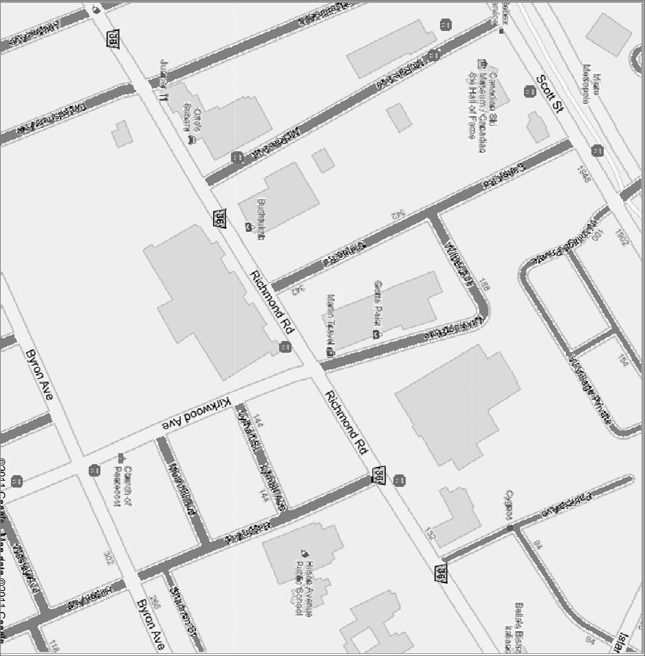
10 BACKGROUND The subject site is located on the northwest corner of Richmond Road and Kirkwood Avenue and is municipally known as 175 Richmond Road. The property has a frontage of approximately 32 m along Richmond Road, a depth of approximately 143 m and a total area of 6,385.6 m 2. The site is both a corner property and a through lot, as it is bounded by Wilbur Avenue to the north. The property is currently occupied by a two storey, multi tenant, commercial building and houses a number of businesses including: Marlin Travel, Nana s Fashion & Beauty Supplies, Ottawa Vocal & Dance Academy, Guillevin International, Elation Centre, Gotta Paint, Genivar Consultants and Signs. These existing commercial uses wrap the corner from Richmond Road onto Kirkwood Avenue with entrances from both streets. 8


11 Existing Building 175 Richmond Road Existing Building along Kirkwood Avenue The existing building occupies the majority of the lot, having been built out to a zero setback where it interfaces with the existing residential community to the west as well as along a portion of Kirkwood Avenue. The existing condition along Kirkwood Avenue varies. Closest to Richmond Road, Kirkwood Avenue has been largely urbanized with a sidewalk, landscaping and curbing along the same side of the street as the existing building. Continuing along the western side of Kirkwood, tenant surface parking separates the building from the street. Along Richmond Road, surface parking separates the building from Richmond Road. As such, the existing building is setback from the street and beyond the typical maximum front yard setback desired along mainstreets. A loading area is located at the north end of the building and is accessed from Wilbur Avenue. There are four loading bays situated in close proximity to the residential neighbourhood to the west of the site in addition to a surface parking area associated with the building. Wilbur Avenue is an un urbanized cross section, with no curbs or sidewalks and terminating informally at Clifton Road to the west. A line of hydro poles running along the south side of Wilbur Avenue, in front of the subject property, will need to be accommodated as part of the redevelopment of this site. The proposed development will need to provide the minimum distance separation typically required between the building and the hydro lines (3m to 5m). The eastern portion of Kirkwood Avenue, up to Wilbur, accommodates informal onstreet/off street parking. 9

12 Area Context and Community Amenities The subject site is located in the east portion of the area referred to commonly as Westboro Village. The area to the east of Westboro Village is characterized as an area in transition, previously dominated by automobile related uses but recently experiencing significant redevelopment including three new residential developments located between Kirkwood Avenue and Island Park Drive. The area is regenerating from its previous lifecycle to a mainstreet pattern of development with commercial uses at grade and residential uses above. This pattern of regeneration will ultimately link Westboro Village with this less established area to the east creating a seamless and continues mainstreet environment. Given the site s location at the edge of a largely established mainstreet to the west and an area in transition to the east, the surrounding context varies. In addition, the extensive lot depth means that the site extends into established residential communities. North The area to the north is characterized by residential development ranging from single detached dwelling and a newer construction of semi detached and multiple attached dwellings that back onto Wilbur Avenue. The area further north includes the Transit Corridor and Westboro Transit Station. Adjacent to the Transit Station is the City s tallest building; a 32 storey residential condominium referred to Minto s Metropole. Residential neighbourhood to the north of the site with 32 storey Metropole in the background. Looking north from the intersection of Clifton Road and Wilbur Avenue. 10


13 East The lands to the east of the site are occupied mainly by the Canadian Bank Note Company, housed in a large, low profile brick building on a site surrounded on three (3) sides by manicured lawns and established trees. The area to the east of the Canadian Bank Note Company is transitioning from largely automobile uses to mixed use development. The Canadian Bank Note Company located on the north side of Richmond Road and east of the subject site. Property to the east of the Canadian Bank Note Company. The site is being redeveloped to a residential condominium with retail at grade. South The south west corner of Richmond Road and Kirkwood Avenue, opposite this subject site includes the Loblaws Superstore food store building, LCBO building and surface parking lot. Both buildings and located along the street edge. The south east corner of the intersection is occupied by existing single detached homes largely converted to at grade commercial uses. Looking southwest from the corner of Richmond West Road and Kirkwood Avenue to the Loblaws Superstore Looking Southeast from the corner of Richmond Road and Kirkwood Avenue. Single family residential and a small law firm on the far left. 11


14 The area to the west of the site is characterized by low profile commercial uses fronting onto Richmond Road and an established residential area consisting of single detached homes along Clifton Road. The Richmond Road commercial corridor continues west and is characterized by a range of retail, automobile and restaurant uses. Looking north along Clifton Road. Visible are single detached homes with the Metropole in the background. A range of commercial uses located along Richmond Road, west of the subject site. An existing commercial development along Richmond Road, west of the site. The north west corner of Richmond Road and Clifton Road is occupied by a three storey office building. Community Amenities The broader neighbourhood surrounding the subject property is a mature community with a full range of community facilities. Amenities in the vicinity of the site include retail ranging from a large food store (the Loblaws Superstore) to small 12

15 boutiques and restaurants within walking distance of this site. The area also benefits from access to public schools (Hilson Avenue School), parks and religious institutions. The map below shows the community amenities surrounding 175 Richmond Avenue. Figure 1: Community Amenities ROAD NETWORK & TRANSIT Roads Richmond Road and Kirkwood Avenue are identified as existing Arterial Roads in Schedule E Urban Road Network of the City of Ottawa Official Plan. Arterial Roads are the major roads of the City intended to carry large volumes of traffic over long distances. Arterials are designed to meet the needs of pedestrians, cyclists, transit buses as well as cars and trucks. Transit The subject site is well serviced by public transit. The site is situated within 600 m of the Westboro Transit Station. According to Schedule D Primary Transit Network Richmond Road, from Island Park Drive west to Tweedsmuir Avenue, Richmond Road is also designated as a Transit Priority Corridor. As such, the subject site is 13
16 serviced by several transit routes. Regular bus routes 2 and 151 run along Richmond Road. Road Widening Requirements Annex 1 of the City s Official Plan protects for a right of way (ROW) width of 26 m measured from the existing centreline of the road for Kirkwood Avenue between Richmond Road and Wilbur Avenue. Staff confirmed at a pre consultation meeting that the City would not require a land dedication along this segment of Kirkwood Avenue. Further, the road widening requirement was not desirable from a traffic management perspective and the requirement has subsequently been removed in Official Plan Amendment No
17 POLICY AND REGULATORY FRAMEWORK Provincial Policy Statement The provincial Policy Statement (PPS), issued under the authority of Section 3 of the Planning Act and in effect since March 1, 2005, provides policy direction on matters of provincial interest related to land use planning. As such, decisions affecting planning matters shall be consistent with policy statements issued under the act. A fundamental tenant of the PPS is the intensification of built up areas to efficiently use land with existing infrastructure and public service facilities to avoid the need for unjustified and uneconomic expansion. As a result, planning authorities must identify and promote opportunities for intensification and redevelopment [Policy ].In addition to meeting the fundamental tenant of the PPS of concentrating growth within the urban area where infrastructure is available, the proposed development meets the following Provincial Policy interests: Promotes efficient development and land use patterns which sustain the financial well being of the Province and municipalities over the long term [Policy a]; Accommodates an appropriate range and mix of residential, employment, recreational and open space uses to meet long term needs [Policy b]; Promotes cost effective development standards to minimize land consumption and servicing costs [Policy e]; Efficiently uses the infrastructure and public service facilities which are planned or available [Policy a]; Identifies and promotes opportunities for intensification and redevelopment where this can be accommodated taking into account existing building stock and areas [Policy ]; Directs development of new housing towards locations where appropriate levels of infrastructure and public service facilities are or will be available to support current and projected needs [Policy c]; Promotes densities for new housing which efficiently use land, resources, infrastructure and public service facilities and support the use of alternative transportation modes and public transit in areas where it exists or is to be developed [Policy d]; 15
18 Promotes land use patterns, density and mix of uses that minimize the length and number of vehicle trips and support the development of viable choices and plans for public transit and other alternative transportation modes, including commuter rail and bus [Policy ]; Supports energy efficiency and improves air quality through land use and development patterns which promote the use of public transit and other alternative transportation modes and improving the mix of employment and housing uses to decrease transportation congestion [Policy b through c]. The proposed development is consistent with the Provincial Policy Statement: The proposal capitalizes on an infill opportunity of an underutilized site with the City s built up area where services are readily available. The proposal for a mixed use development, consisting of residential and commercial uses, contributes to the creation of complete communities and development patterns that are more sustainable over the long term. City of Ottawa Official Plan 2003, Consolidated 2007 The City of Ottawa Official Plan is composed of eight Sections, each addressing a different aspect of the planned function of the City as a whole. Section 2 of the City of Ottawa Official Plan 2003 provides Strategic Direction for growth and development within the City. The Plan anticipates that much of the demand for new housing after 2006 will be for smaller units such as apartments. It is expected that two thirds of the added housing stock located outside of the Greenbelt will be in the form of single detached homes, while in the Greenbelt, one third of housing growth will be in the form of apartments. Ottawa expects to support this growth by managing it in ways that support healthy, liveable communities. Growth will be directed towards key locations with a mix of housing, shopping, recreation and employment and which are easily accessible by transit. In order to meet these and other objectives of the Official Plan, the City has committed to pursuing strategic directions in four (4) key areas, two (2) of which are applicable and relevant to this proposal. 16
19 Managing Growth The City will manage growth by directing it to the urban area where services already exist or where they can be provided efficiently. Growth in the urban area will be directed to areas where it can be accommodated in compact and mixed use development, and served with quality transit, walking and cycling facilities. Creating Liveable Communities The City will provide opportunities to increase the supply of affordable housing throughout the rural and urban areas. Growth will be managed in ways that create complete communities with a good balance of facilities and services to meet people s everyday needs, including schools, community facilities, parks, a variety of housing, and places to work and shop. Attention to design will help create attractive communities where buildings, open space and transportation work well together. Land Use Designations Traditional Mainstreet The southern portion of the Subject Site is designated Traditional Mainstreet while the northern portion is designated General Urban Area on Schedule B Urban Policy Plan of the City of Ottawa Official Plan (OP) (Figure 2: Urban). The exact boundary of each designation is not clearly delineated as the boundary of the Traditional Mainstreet designation is flexible as per Policy of the OP. On lots where development has the potential to develop both adjacent to the street and to the rear of the property, the Mainstreet designation will apply to the entire property. The intent of the Traditional Mainstreet designation is to achieve compact, mixeduse, pedestrian oriented development patterns. These streets are considered to be the areas that offer the most significant opportunities for intensification. This intensification is anticipated to occur through the redevelopment of such sites as vacant lots, aging strip malls, and former parking lots. The Official Plan recognizes that some Mainstreets, developed in the 1950 s and 60 s will exhibit characteristics of both the Traditional Mainstreets as well as the Arterial Mainstreets, which are generally more auto oriented in design. As a result, the Plan promotes redevelopment in a manner which will locate buildings close to the street and is more pedestrian oriented. 17

20 Figure 2: Urban Policy Plan Schedule B of Official Plan LEGEND Subject Site General Urban Area Designation Traditional Mainstreet Designation The planned function for all Mainstreets is as a mixed use corridor with the ability to provide a wide range of goods and services for neighbouring communities and beyond. As such, a wide range of uses is permitted within the Mainstreets designation, including retail and service commercial uses, offices, residential and institutional uses. The plan generally supports building heights in the range of four (4) to six (6) storeys on Traditional Mainstreets, however, greater building heights will be considered in any of the following circumstances: a. Specific building heights are established in the zoning by law based on a Community Design Plan or Council approved study; b. The proposed building height conforms with prevailing building heights or provides a transition between existing buildings; c. The development fosters the creation of a community focus where the proposal is on a corner lot, or at a gateway location where there are opportunities to support transit at a transit stop or station; 18
21 d. The development incorporates facilities, services or matters as set out in Section with respect to the authorization of increases in height and density that, in the opinion of the City, significantly advance the vision for Mainstreets; e. Where the application of the provisions of Section and Section 4.11 determine that additional height is appropriate. General Urban Area The General Urban Area designation applies generally to the northern portion of the lands. This designation accommodates development that meet the needs of all ages, incomes, and life circumstances in order to create complete, sustainable communities. A wide range of uses are permitted within the General Urban Area, including all types and densities of residential development, employment, retail, service, cultural, leisure, entertainment and institutional uses. The City supports infill development within the General Urban Area, provided that the existing character of the surrounding community is recognized and the new development complements and enhances the communityʹs desirable characteristics. When considering an application for intensification, the City assesses how the proposed development will meet the compatibility and objectives (Section 2.5.1) and compatibility policies (Section 4.11). Further, the City will consider the proposed developmentʹs contribution to the maintenance and achievement of a balance of housing types and tenures. The proposed development conforms to the Official Plan in that: The General Urban Area and Traditional Mainstreet designations permit the proposed residential and at grade commercial uses. The General Urban Area does not include limitation on height, however, Traditional Mainstreet designations permits a general height of 4 to 6 storeys with greater building heights permitted in a number of circumstances. The proposal meets the criteria for additional height in that the site is located within 600 m of a rapid transit station providing an opportunity to support rapid transit and the development meets the compatibility criteria in Section and 4.11 (discussed below) in the Official Plan. The property is well suited to accommodate additional building height to 9 storeys, above 6 storeys, given that other taller buildings define this segment of Richmond Road. The site is a corner lot located at a significant intersection allowing for the creation of a community focus or gateway 19
22 building treatment designed in conformity with the City s Urban Design objectives and criteria. The proposal supports the planned function of this site and area, contributing to complete and more sustainable communities and to an integrated and continuous mainstreet pattern of development along Richmond Road. Compatibility & Community Design (Section 2.5.1) Section addresses Compatibility and Community Design, particularly as it relates to infill development in established areas. Development must be sensitive to and compatible within existing communities that have developed over long periods of time. Compatible development is defined as development that although not necessarily the same as or similar to existing buildings in the vicinity, nonetheless enhances an established community and coexists with existing development without causing undue adverse impact on surrounding properties. In other words, it fits well within the physical context and works well among those functions that surround it. The proposed development achieves, among others, the following design objectives and principles set out in Section 2.5.1: 1. The proposal reflects a thorough and sensitive understanding of place, context and setting. The proposed development responds to the unique site conditions including unusual depth that extends north and interfaces with an established low profile residential neighbourhood. The design incorporates elements such as transition, staggered heights, step backs and distance separation to ensure that the development responds to the Traditional Mainstreet character along Richmond Road as well as the residential neighbourhood in behind. 2. The proposal defines quality public and private space through development. The proposal includes an appropriate, at grade transition to the public street with retail uses along Richmond Road and street oriented residential units along both Kirkwood Avenue and Wilbur Avenue. Both commercial and residential building components will have at grade pedestrian access. Landscaped open space occupies 43% of the lot area. The area will be framed by the proposed development providing for a sheltered yet accessible public amenity space. The amenity space is accessible by a portico functioning as a transition and access point. 20
23 3. The proposal encourages a continuity of street frontages. The existing building is setback from the street and separated by surface parking located between the building and the sidewalk. The proposed development will bring the building close to the street, framing the sidewalk and locate the parking underground. 4. The development addresses the relationship between buildings and between buildings and the street. The building along Richmond Road incorporates a podium, setting the main portion of the building back at the second storey. The setback ensures that the podium frames the street while the main mass of the tower doesn t cast shadow or impose on the pedestrian experience at grade. 5. To building design will integrate the development to complement and enliven the surroundings. The proposal will incorporate commercial uses along Richmond Road and ground oriented townhouse units will flank the 6 storey building along Kirkwood Avenue and Wilbur Avenue. The mix of uses and built form will contribute to activity and animation at grade. 6. The proposal accommodates the needs of a range of people of different incomes and lifestyles at various stages in the life cycle. The proposed development includes condo apartments and ground oriented townhouse units ranging in size and will contribute to the range of housing options available in this community. Compatibility (Section 4.11) The criteria in Section 4.11 provides a means to objectively evaluate the compatibility of infill development. The following is an evaluation of the criteria in relation to the proposed development (on following page). 21
24 COMPATIBILITY CONFORMITY CRITERIA Traffic A Traffic Study will be prepared evaluating the impact of the proposed development on the surrounding area. Generally, the property is situated within an established road network and in close proximity to the City s rapid transit. The site is situated within proximity to three (3) existing arterial roads. Richmond Road, Kirkwood south of Richmond Road and Scott Street to the north and is located less than 600 m from the Westboro Transit Station. In addition, the mixed use character of the existing area is anticipated to reduce residents reliance on private automobiles. The proximity to community amenities including Loblaws directly across the street and easy access to the rapid transit station, should all contribute to a reduction in private vehicle use. Vehicular Access The site will be served by a singular, two (2) way driveway providing access to the underground parking structure. This single vehicular access will replace the existing four (4) loading bays and the surface parking area currently accessed from Wilbur Avenue and in close proximity to existing residential as well as all existing surface parking. Given that parking is located underground, the majority of impacts related to noise and headlight glare will be absorbed internally. The egress/ingress will be buffered from the adjacent residential via landscaping and shrubbery, protecting the existing dwelling from impacts of noise, headlight glare and loss of privacy. Parking Requirements A total of 304 parking spaces are being provided. The proposed number of parking spaces exceeds the By law requirement. This will ensure that all parking demands are accommodated on site, avoiding potential for any spillover parking on the adjacent residential streets. 22
25 Building Height and Massing The proposed building height and massing are consistent with the planned function of the area and with existing and recently approved building heights along the Richmond Road. The site is designed Traditional Mainstreet and General Urban Area. The Traditional Mainstreet designation permits building heights in the range the 4 to 6 storey range with greater building heights permitted in any number of circumstances including proximity to transit and where the building height conforms with prevailing building heights among others. This site is also recognized in the Richmond Road/Westboro Secondary Plan for this area as being suitable for greater building heights. Recently constructed and approved development along Richmond Road are in the 6 to 12 storey range including three (3) proposed developments to the east and in close proximity of this site which range from 6 to 9 storeys. The building design incorporates elements which contribute to a human scale and enhance pedestrian comfort. These features include a strong podium along Richmond Road with the main building mass set back from the edge of the podium and the use of groundoriented development along Kirkwood Avenue, Wilber and internally to the site where it interfaces with the rear yards of the residential properties along Clifton. In addition, the building mass has been moulded through a combination of step backs and strategic recessing, further setting the taller portions of the building. Steps back at the 3 rd and 4 th floor and again as the 5 th and 6 th floor further increasing the distance separation between existing and proposed development. These design elements help to integrate the building into the existing context and to achieve an appropriate and reasonable transition from the existing residential 23
26 neighbourhood to the west. Pattern of Surrounding Community The pattern of the surrounding community varies due to the site s unique size and depth. The area to the north of the site, beyond Wilbur Avenue, is characterized predominantly by residential uses. To the west, the site abuts the established residential community of Clifton Road. Along Richmond Road, the area is characterized as a mixed use corridor and the re emerging pattern of development is similar to that of what is proposed at this location. The lands to the east, opposite Kirkwood Avenue, are occupied by a large industrial use which houses the Canadian Banknote Company. In order to respond to this varying context, the development incorporates a number of elements to assist in achieving the appropriate interface with the surrounding community. The line of townhouses that flank the 6 storey portion of the building establish a similar façade and experience as that of other side streets in the neighbourhood. The use of a ground oriented built form at grade also helps to establish a comparable relationship in terms of scale and size with the surrounding residential community. The portion of the building responding to context along Richmond Road incorporates a podium and commercial uses at grade contributing to a continuous, pedestrian oriented environment. It also reinforces the planned function of the property in accordance with its Traditional Mainstreet designation. Most importantly, the building respects the established rhythm and typical lot depth of lots abutting Richmond Road. Outdoor Amenity Areas The outdoor amenity areas of adjacent residents will be protected. To ensure there is no overlook or loss of privacy resulting from this proposal, the building will step back at the 3 rd and 4 th floor, as well as the 5 th and 6 th floor. 24
27 In addition, the majority of the building will be setback approximately 15 m from the interior property line. This generous distance separation further limits the possibility of overlook into adjacent outdoor amenity areas. Loading Areas, Service Areas and Outdoor Storage Service Areas and Outdoor Storage are not proposed as part of this development as the size of the proposed commercial uses along Richmond Road does not require a dedicated loading area. Lighting Lighting will meet the City s standards, with no anticipated impacts on adjacent development. Noise and Air Quality Sunlight and Microclimate No significant impacts related to noise or air quality are anticipated as a result of this proposal. Shadows cast primarily north and east of the subject site onto Wilbur Avenue and Kirkwood Avenue without creating undue adverse impact on adjacent and surrounding residential communities. Additionally, the stepping back and sculpting of the building mass, in addition to significant distance separation ensures that there are virtually no shadowing impacts on adjacent properties (see Appendix C for Sunshadow Study). Supporting Neighbourhood Services The site is well served by existing community amenities: Hilson Avenue Public School; Westboro Montessori Public School; Byron Linear Park; Lion s Park; Mahoney Park; Commercial and Retail uses along Richmond Road. New residents will strengthen existing amenities and will contribute to the critical mass required to attract other amenities to the area. 25
28 Official Plan Amendment 76 Official Plan Amendment 76 was adopted by Council in June 2009 as part of the mandated 5 year Official Plan review and subsequently appealed to the Ontario Municipal Board. The majority of policies of the Traditional Mainstreet and General Urban Area designations remain under appeal. Despite the appeals, the proposed development must have regard for the policies of OPA 76. Managing Growth within the Urban Area OPA 76 acknowledges that intensification is the most cost effective pattern of development for the provision of municipal services, transit and other infrastructure while supporting a cleaner, healthier city and creating more complete communities. Therefore, growth within the designated urban area will be directed to locations with significant development potential including Mainstreets. To achieve compatibility between existing and planned built form, emphasis will be placed on good urban design and architecture. In order to encourage growth within the urban area, OPA 76 sets out minimum density targets for areas with the greatest potential to support rapid transit network including Traditional Mainstreets inside the Greenbelt. A density target of 200 people and jobs per gross hectare at 2031 has been established for Richmond Road (north of Carling). In support of the above noted targets, all development applications will be assessed against the minimum density targets and required to achieve a high standard of urban design. Designation and Land Use The site maintains its Traditional Mainstreet and General Urban Area designations. The policies for the designations remain largely unchanged with respect to land uses and planned function. Redevelopment and infill are encouraged along the Traditional Mainstreets in order to optimize the use of land through intensification and in a building format that encloses and defines the street edge and provides direct pedestrian access to the sidewalk. As such, the development maintains conformity with OPA 76. Building heights along Traditional Mainstreets remain, generally speaking, limited to six (6) storeys. However, greater heights may be considered in accordance with policies 8 through 14 of Section 4.11 Urban Design and Compatibility. Section 4.11 Urban Design and Compatibility Although much of the evaluative criteria assessing compatibility remains the same, OPA 76 provides further guidance with respect to good design and integration. 26
29 Policy states that the City in assessing redevelopment proposals will give careful consideration as to whether the design improves the character and quality of the area and its functions. New buildings should be massed to fit harmoniously with the surrounding area and properly integrated to maintain and improve the character of well established neighbourhoods. Despite the fact that the height increase being request for the proposed development maintains a medium profile (typically defined as a 5 to 9 storey range), increases in height along Mainstreets may be considered in the same circumstances as high rise development. New policies have been incorporated specifically addressing the location, design and integration of taller buildings. Policies and direct taller buildings to: Lands designated Traditional Mainstreet; Within 600 metres of a rapid transit station; Where a community design plan, secondary plan or other similar Councilapproved planning document identifies locations where there are significant opportunities to support transit at a transit stop or station by providing a pedestrian and transit oriented mix of uses and activities; Within areas where a built form transition is appropriate as prescribed by policy As per policy , appropriate transition can be accomplished by incorporating the following design measures: a) Incremental changes in building height (e.g. angular planes or stepping building profile up or down); b) Massing (e.g. inserting ground oriented housing adjacent to the street as part of a high profile development or incorporating podiums along a Mainstreet); c) Character (e.g. scale and rhythm, exterior treatment, use of colour and complementary building finishes); d) Architectural design (e.g. the use of angular, cornice lines); and e) Building setbacks. The proposed development is consistent with OPA 76: OPA 76 directs taller buildings to locate along Traditional Mainstreets in the following circumstances:, in areas where other taller buildings already exist, within 600 m of rapid transit or where appropriate transition can be achieved. The proposed development is located along Richmond Road, a 27
30 Traditional Mainstreet and an arterial roadway with existing medium to high profile buildings, the site is located within 600 m of the Westboro Rapid Transit Station and careful attention has been paid to the arrangement of built form and density on site to ensure appropriate transition. The proposal incorporates low profile, ground oriented housing where the development interfaces with the low profile residential community. Further, the use of a podium to anchor the building along Richmond Road creates a sense of human scale and creates a strong street presence. In order to achieve the appropriate transition, the tallest built form is oriented along Richmond Road, at the edge of the site. The building transitions from nine storeys at Richmond Road to six storeys further into the site, with the 5 th and 6 th storeys are stepped back from the edge of the building further reducing the building mass. The transition also occurs at grade. By incorporating two storey townhouses at grade all the way around the six storey building, while stepping back the 4 th through 6 th floors, the experience at grade remains that of low profile development. The proposed uses, the amount of landscaped open space along with the arrangement of buildings and density on site enhances the development and ensures successful integration into the existing community. Light Rail Transit Official Plan Amendment 76 notes planned improvements to the City s transit infrastructure. The revised Schedule D Primary Transit Network identifies the Westboro Transit Station as a future Light Rail Transit station increasing the capacity of the station. The proposed development will support this significant investment in the City s transit infrastructure through increased density within a 600 m radius of the rapid transit station. Richmond Road/Westboro Secondary Plan and Community Design Plan The site is located within the boundaries of the Richmond Road/Westboro Community Design Plan and Secondary Plan. The purpose of these documents is to translate the principles and policies of the Official Plan to the community level. The Community Design Plan (CDP) and Secondary Plan must conform to the Official Plan. 28
31 The Secondary Plan area is subdivided into nine (9) sectors with the subject site located in Sector 6 East Village. The Secondary Plan supports the evolution of the East Village to a more traditional mainstreet character as an extension of Westboro Village to the west and West Wellington community to the east. While the Secondary Plan generally supports building heights in the four (4) to six (6) storey range, greater building heights will be considered in any of the following circumstances [Policy 1.3.3]: Specific building heights are established in the zoning by law based on the Richmond Road/Westboro CDP or other Council approved study; The building height conforms with prevailing building heights or provides a transition between existing buildings; The development fosters the creation of a community focus where the proposal is on a corner lot, or at a gateway location or at a location where there are opportunities to support transit at a transit stop or station; The development incorporates facilities, services or matters as set out in Section of the Official Plan for increases in height and density that significantly advance the vision for Mainstreets; Where the application of the provisions of Section Compatibility and Community Design and Section 4.11 Compatibility of the Official Plan determine that additional height is appropriate. In the East Village, maximum building heights will be maintained at four (4) storeys where lots are less than 45 m in depth and back onto low rise residential and generally up to six (6) storeys on lots of greater depth. The General Maximum Building Height Schedule C identifies the entire site as being suitable for development in the 4 to 6 storey range. However, the Secondary Plan [Policy f] specifically contemplates the property at 175 Richmond Road, recommending that the site be rezoned to Traditional Mainstreet for mixed use development in the event that redevelopment is proposed. Further, the property specific policies of the Secondary Plan recognize that higher building heights may be possible on this site given the lot size, provided that redevelopment is compatible with and provides an appropriate transition to the adjacent low rise residential neighbourhood. In addition to the policy direction, The Appendix to the Secondary Plan sets out infill design guidelines specific to each of the sectors. Development in the East Village should: 29
32 Restore a continuity in the landscaping of Richmond Road, especially on its north side between Tweedsmuir and Kirkwood Avenues; Minimize the impact of new housing units overlooking existing residences; and Promote the reuse/redevelopment of existing industrial and automotiveoriented uses to traditional mainstreet type of uses. The proposed development fully conforms with the Secondary Plan as follows: The proposed development maintains the general six storey height limit with greater building heights assigned to the portion of the site along Richmond Road. The Secondary Plan recognizes that greater building heights may be possible, given the lot size and provided that redevelopment is compatible with and provides an appropriate transition to the adjacent low rise residential. The nine storey portion of the building is limited to Richmond Road with the building scaled back and pulled away from the interior side yard where it interfaces with the low rise residential community to the west. A series of step backs at the 3 rd, 4 th and the again 5 th and 6 th storeys helps to achieve a transition between the existing residential community and the proposed building. This sensitive approach to the design ensures that the building is compatible with the surrounding community and provides an appropriate transition. URBAN DESIGN GUIDELINES Urban Design Guidelines for Development along Traditional Mainstreet The Urban Design Guidelines for Development along Tradition Mainstreets document was approved by council on May 24, The guidelines apply to all streets throughout the City, identified as a Traditional Mainstreet within the Official Plan and provide guidance to the proper development of these important streets. The guidelines address seven (7) components including: Streetscape, built form, pedestrians and cyclists, vehicles and parking, landscape and environment, signs, and servicing and utilities. The proposed development meets the following applicable design guidelines, among others: Aligns the building with the existing average setback of adjacent buildings in order to create a visually continuous streetscape. 30
33 Uses periodic breaks in the street wall or minor variations in building setback and alignment to add interest to the streetscape. Ensures sufficient light and privacy for residential properties by ensuring that new development is compatible and sensitive with adjacent uses with regard to maximizing light and minimizing overlook. Sets back the upper floors of taller buildings to help achieve human scale and more light on the sidewalks. Highlights the building at the corner with special treatment such as a corner feature while continuing the same level of architectural detailing around both sides of the building. The front door is located to face the mainstreet and be directly accessible from the public sidewalk. Shared vehicular access to parking areas reduces the extent of interruption along the sidewalk and streetscape. Design Guidelines for Transit Oriented Development The Urban Design Guidelines for Transit Oriented Development document was approved by Council on September 26, The guidelines apply to all development throughout the City within a 600 m walking distance of a rapid transit stop or station to provide guidance to the proper development of these strategically located properties. The guidelines address six (6) components including: Land use, layout, built form, pedestrians and cyclists, vehicles and parking, and streetscape and environment. The proposed development meets the following applicable design guidelines, among others: The proposed development includes transit supportive land uses within a 600 m walking distance of a rapid transit station or stop including townhouses and apartments. The proposal creates a multi purpose destination by contributing a mix of housing types to the area where residents can meet many of their daily needs locally, thereby reducing the need to travel. The building steps back at the 4 th storey in order to maintain a more human scale along the sidewalk and to reduce shadow and wind impacts on the public street. The building provides architectural variety on the lower storeys of buildings to provide visual interest to pedestrians. The development incorporates windows and doors to make the pedestrian level façade of walls facing the street highly transparent in order to provide ease of entrance, visual interest and increased security through informal viewing. 31
34 The design and location of the entrance to the underground parking lot minimizes the number of vehicle crossings over primary pedestrian routes. Urban Design Guideline for Low Medium Density Infill Housing The Urban Design Guidelines for Low Medium Density Infill Housing document provides a series of design guidelines for infill housing to help fulfill some of the design strategies outlined in the Official Plan. The guidelines help achieve a good fit in an established community by addressing major elements including public streetscapes, building design, parking and garages, heritage building alterations/additions and service elements. The proposed development meets the majority of the applicable guidelines with the most notable highlighted below. The proposal provides a streetscape that is inviting, safe and accessible, emphasizing the ground floor and street façade with principal entries, windows, porches, balconies and key internal uses at street level. The existing character along Kirkwood Avenue, north of Richmond Road, is less desirable with asphalt parking lots and few trees lining the street and no public sidewalks. The development will encourage change and a more desirable pedestrian character and pattern, which may encourage further positive change for future development. The proposal expands the network of public sidewalks for pedestrian safety, including crosswalks to complete the network. The development faces and animates the public street. The proposal incorporates the appropriate separation distance between infill housing blocks ensuring the appropriate light, view and privacy considering: building heights, site orientation and location of windows. The proposal incorporates an appropriate angular plane and provides a suitable buffer zone in order to protect a neighbours right to adequate light, view and privacy. A transition in heights is created through the harmonization and manipulation of mass. Architectural features such as porches, bays and other building elements visually reduce the mass of the new buildings. The building faces are detailed with inviting entrances and living spaces close to the ground that offer eyes on the street and contribute to the amenity of the public realm. On corner lots, all sides of a building that face public streets should display a similar and comparable level of quality and detail. All sides of infill buildings should be well designed, not just the front. 32

35 Proposed development provides shared underground parking that is contained internally on the site minimizing the amount of paved area, pedestrian/vehicular conflicts and maximizes room for soft landscaping. The proposed development has regard for and meets the majority of applicable design guidelines. REGULATORY FRAMEWORK City of Ottawa Comprehensive Zoning By law, The site is currently zoned General Industrial, Subzone 1 [IG1]. The purpose of the General Industrial [IG] zone is to accommodate a wide range of low to moderate impact, light industrial uses and to allow a variety of complementary uses such as recreational, health and fitness uses and service commercial (e.g. convenience store, personal service business, restaurant, automobile service station and gas bar), to serve the employees, the general public in the immediate vicinity, and passing traffic. A range of uses are permitted in the IG zone including, among others: automobile body shop emergency service heavy equipment and vehicle sales 33
36 light industrial uses parking lot storage yard warehouse. The range of uses permitted under the existing zoning is not in keeping with the Official Plan designation or applicable Secondary Plan and not compatible with the surrounding land uses. The proposed Zoning By law Amendment will bring the site into conformity with the Official Plan and Secondary Plan and introduce uses that better compliment the surrounding community. Under the existing zoning, the permitted height is 11 m within 20 m of a property line abutting a residential zone and 22 m thereafter. Based on this provision, the eastern portion of the site beyond the 20 m setback could develop with a building 22 m in height all the way from Richmond Road to Wilbur Avenue. The entire building could contain a range of industrial uses which have the potential to be impactful on the surrounding community. Based on the above, it is proposed that the site be rezoned to Traditional Mainstreet [TM]. The Traditional Mainstreet zoning will allow a mix of non residential and residential uses and will contribute to creating a complete and continuous traditional mainstreet environment along Richmond Road. The TM zoning will also implement the planned function of this site as described in the Richmond Road/ Westboro Secondary Plan. Building heights on the property would be project specific, recognizing the gradual and staggered building heights proposed by Claridge. REQUESTED ZONING BY LAW AMENDMENT As discussed previously, it is suggested that the site be rezoned to a Traditional Mainstreet zone. The Traditional Mainstreet zoning would permit the proposed development and establish new performance standards. The table below summarizes the standard provisions of the TM zone and compares them against the proposed development. Areas of non compliance are identified in red under the PROPOSED heading. PROVISION REQUIREMENT PROPOSED LOT AREA (MIN) No Minimum 6, m 2 LOT WIDTH (MIN) No Minimum varies MAX. FRONT YARD 2 m 3.4 m SETBACK 34
37 INTERIOR SIDE YARD SETBACK 3 m max. between a mixed use building and another mixed use building 1.1 m 3 m min. for a mixed use building abutting a residential zone 9.3 m MINIMUM CORNER SIDE YARD SETBACK MINIMUM REAR YARD SETBACK (ABUTTING A RESIDENTIAL ZONE) BUILDING MIN. 3 m, except any part of a 0.89 m building above 15 m for which an additional 2 metre setback must be provided 7.5 m 4.9 m 6.7 m HEIGHT MAX m 29 m Where the building height is greater than four storeys or 15 m, at and above the fourth storey or 15 m whichever is the lesser a building must be setback a minimum of 2 m more than the provided setback from the front lot line 0 m setback at the 4 th storey or 15 th m FLOOR SPACE INDEX (MAX) WIDTH OF LANDSCAPED AREA (MIN) No part of a building on a lot that abuts an R1, R2, R3 or R4 zone may project above a 45 degree angular plane measured at a height of 15 m from a point 7.5 m from the rear lot line, projecting upwards towards the front lot line No Maximum 3 m abutting a residential zone, may be reduced to 1 m where a To be confirmed No Maximum 9.3 m 35
38 minimum 1.4 m high opaque fence is provided Additional amendments may be identified following staff review, technical circulation and as a result of revisions to the Site Plan. SUPPORTING STUDIES Transportation Demand Management A traffic study was prepared by Novatech to assess the impact of the 241 residential unit development on the existing street network/surrounding community and to identify ways to reduce the number of vehicular trips to and from the site. The Novatech study evaluated potential strategies to achieve a higher modal split for this project identified in the Richmond Road/Westboro Transportation Management Implementation Plan (TMIP). Novatech s study identified a number of measures from the TMIP that could be implemented at the site plan level including: Restricting availability of on site parking; Unbundling parking space costs from dwelling/commercial units; Offering bonus zoning where certain restrictions may be relaxed for developments that incorporate TDM measures. Examples of bonus zoning could include increased building height in exchange for providing free transit pass/car share (i.e. Vrtucar) memberships to residents for one year. The TMIP suggests that unbundling parking spaces can be achieved in a number of ways including: Condominium Association owning the parking spaces and renting them out to tenants on an as needed basis; Parking can be rented or bought separately when the apartment or commercial space is bought or leased; Parking can be added as a separate line item in the purchase agreement so that it can be negotiated; or Tenants can rent spaces from each other in order to match supply with demand. The TMIP also recommends that the City consider changing the parking cap from 1.75 to 1.5 spaces per unit for the areas within 600 meters of transit stations. A cap of 1.5 spaces per dwelling unit would result in a maximum of 381 parking spaces for 36
39 the residential component alone, whereas a total of 310 parking spaces are being provided to serve both the proposed commercial and residential uses. The Novatech study concludes that in addition to using a lower parking ratio that the proposed 1.5 spaces per dwelling unit, the proposed development could achieve a higher modal split by incorporating a number of the practices identified above. The study recommends that the developer consider the potential to provide free transit passes and/or dedicated car share vehicles in exchange for bonus zoning. PLANNING CONSIDERATIONS It is our professional planning opinion that the requested Zoning By law Amendment represents good land use planning, is appropriate for the subject property and is in the public interest for the following reasons: The proposal is consistent with the Provincial Policy Statement with respect to the redevelopment of an underutilized, serviced site located within the urban area. The proposal conforms with the goals, objectives and policies for the General Urban Area and Traditional Mainstreet designations in the Official Plan. The General Urban Area designation permits a range of uses including all types and densities of housing. The Traditional Mainstreet designations generally supports building heights in the four (4) to six (6) storey range with greater building considered in a number of circumstances including proximity to transit and where compatibility with the surrounding community can be demonstrated. This site is located within 600 m of the Westboro Rapid Transit Station and as such, increased height and density at this location will support the public transit. The proposed development supports the planned function of the Richmond Road/Westboro Secondary Plan which recommends rezoning this particular property to a Traditional Mainstreet zone to allow for mixed use development that completes the mainstreet fabric along Richmond Road. The Secondary Plan generally supports building heights in the 4 to 6 storey range along Richmond Road. However, specific to this site, the Plan acknowledges that given the lot size, greater building heights are possible provided that redevelopment is compatible with and provides an appropriate transition to the adjacent low rise residential neighbourhood. 37
40 The proposal meets the criteria for increased building height as set out in the Secondary Plan. The density and height have been sited and concentrated along Richmond Road away from the single family homes to the west. The building mass has been sculpted and pulled back away from the shared property line ensuring that there are no undue adverse impacts on the surrounding residential community such as loss of light or sunshadowing. The building incorporates step backs at the 3 rd and 4 th storeys and again at the 5 th and 6 th storeys creating additional distance separation in addition to the at grade setback which ranges between 9 and 15 m.. The area between the buildings and the property line will include landscaped providing additional screening. Both the Official Plan and the Secondary Plan contemplate greater building heights in a number of circumstances including where the application of the provisions of Section and Section 4.11 of the Official Plan determines that additional height is appropriate. The proposal fulfills the City s compatibility criteria established in the Official Plan (Section and 4.11) including provisions relating to building height and massing, pattern of surrounding community, traffic and sunshadowing. The site meets the criteria for the location of taller buildings as well as the design objectives established in OPA 76. Although this criteria typically applies to high rise buildings, development along Traditional Mainstreet greater than 6 storeys will also be evaluated for its appropriateness in accordance with these policy directions. The site is located within 600 m of rapid transit and achieves an appropriate transition. The use of groundoriented housing, podium along Richmond Road, setbacks and step backs in the building along with the careful siting of building on site ensure compatibility and an appropriate transition to existing development. The proposal will improve the character of the existing area through quality architecture and sensitive design. The development will replace an existing non conforming building, built out to the lot lines with front yard parking that contributes little to the surrounding area. The residential development with retail at grade along Richmond Road will enhance the streetscape and introduce uses that are more compatible and less impactful to the residential community immediately to the west of this site. The proposal meets the intent and spirit of the City s Design Guidelines for Traditional Mainstreet, Transit Oriented Development and Low to Medium Density Infill Housing. The proposal meets key design considerations related 38
41 to building placement and orientation, animating and addressing the street, pedestrian orientation and accessibility, human scale and meaningful landscaped open space. The existing General Industrial Zoning permits a range of uses including automobile body shop, heavy equipment and vehicle sales and storage yard among others that have the potential to be impactful on the adjacent residential community. Additionally, the current zoning provisions allow a building ranging in height from 11 m up to 22 m over the entire the site. As such, the existing zoning is not in keeping with the planned function or intent expressed for this site in the applicable policy framework and has the potential to negatively impact the surrounding community. The Official Plan designates this site as Traditional Mainstreet which permits a range of non residential and residential uses but excludes general industrial uses such as those currently permitted by the existing zoning. The Secondary Plan calls for this site to be rezoned to a Traditional Mainstreet to allow for mixed use development while encouraging the evolution of the East Village to a more traditional mainstreet character. The proposed Zoning By law Amendment will bring the site into conformity with both the Official Plan and the Secondary Plan. Overall, the proposed development achieves a good fit with the existing neighbourhood. The development will contribute positively to the streetscape as well as the surrounding community while sensitively increasing height and density to meet the City s goals and policy objectives. 39
42 APPENDIX A: PRELIMINARY SITE PLAN 40

43
44 APPENDIX B: SUNSHADOWING STUDY 41


45 MARCH 21, DST 12:00 pm 2:00 pm 4:00 pm 10:00 am 12:00 pm 2:00 pm 4:00 pm 10:00 am 12:00 pm 2:00 pm 4:00 pm DECEMBER 21 SEPTEMBER 21, DST JUNE 21, DST 10:00 am 10:00 am SHADOW STUDY 12:00 pm 2:00 pm 4:00 pm
178 Carruthers Properties Inc.
 178 Carruthers Properties Inc. Planning Rationale for 178 Carruthers Avenue Site Plan Control Application June 2014 Table of Contents 1.0 Introduction 2.0 Overview of Subject Property 3.0 Current Zoning
KANATA CENTRUM 255 KANATA AVENUE OFFICIAL PLAN AMENDMENT ZONING BY-LAW AMENDMENT
 KANATA CENTRUM 255 KANATA AVENUE OFFICIAL PLAN AMENDMENT ZONING BY-LAW AMENDMENT JUNE 2015 PREPARED BY: FOTENN Consultants Inc. 223 Mcleod Street Ottawa, ON K2P OZ8 (613) 730-5709 PREPARED FOR: Kanata
[PLANNING RATIONALE] For Site Plan Control and Lifting of Holding Zone By-Law 101 Champagne Avenue. May 23, 2014
![[PLANNING RATIONALE] For Site Plan Control and Lifting of Holding Zone By-Law 101 Champagne Avenue. May 23, 2014](/thumbs/75/71599615.jpg "[PLANNING RATIONALE] For Site Plan Control and Lifting of Holding Zone By-Law 101 Champagne Avenue. May 23, 2014") [PLANNING RATIONALE] For Site Plan Control and Lifting of Holding Zone By-Law 101 Champagne Avenue May 23, 2014 Contents 1.0 Introduction... 2 2.0 Site Context... 2 2.1 Adjacent Uses... 2 Figure 1: Site
[PLANNING RATIONALE] For Site Plan Control and Lifting of Holding Zone By-Law 101 Champagne Avenue May 23, 2014 Contents 1.0 Introduction... 2 2.0 Site Context... 2 2.1 Adjacent Uses... 2 Figure 1: Site
YONGE STEELES CORRIDOR SECONDARY PLAN. Young + Wright / IBI Group Architects Dillon Consulting Ltd. GHK International (Canada) Ltd.
 Ltd.") PART A: PREAMBLE 1.0 PURPOSE The purpose of this Secondary Plan is to provide a development framework for intensification of the Yonge/ Steeles corridor including the north side of Steeles Avenue West
PART A: PREAMBLE 1.0 PURPOSE The purpose of this Secondary Plan is to provide a development framework for intensification of the Yonge/ Steeles corridor including the north side of Steeles Avenue West
Planning Rationale Fernbank Road, Ottawa. Major Zoning By-law Amendment and Site Plan Control Application Ontario Inc.
 Planning Rationale Major Zoning By-law Amendment and Site Plan Control Application 5264 Fernbank Road, Ottawa 1872089 Ontario Inc. March 2014 Planning Rationale Major Zoning By-law Amendment and Site Plan
December 16, Gary Sealey Kanata Beaverbrook Community Association Inc. 2 Beaverbrook Road Ottawa ON K2K 1L1. Dear Mr. Sealey
 December 16, 2013 Gary Sealey Kanata Beaverbrook Community Association Inc. 2 Beaverbrook Road Ottawa ON K2K 1L1 Dear Mr. Sealey Re: Letter of Opinion - Update 1131 Teron Road Application # D02-02-12-0041
CONTENTS 8.0 LAND USE 8.1 GENERAL LAND USE 8.2 RESIDENTIAL 8.3 MIXED USE 8.4 COMMERCIAL 8.5 EMPLOYMENT LANDS
 8-2 Land Use 8.0 LAND USE CONTENTS 8.1 GENERAL LAND USE 8.1.1 Uses provided for in all Land Use Designations 8.1.2 Uses prohibited in Hazardous Lands, Hazardous Sites and Special Policy Areas 8.1.3 Uses
ELMVALE ACRES SHOPPING CENTRE MASTER PLAN
 ELMVALE ACRES SHOPPING CENTRE MASTER PLAN Contents 1.0 INTRODUCTION... 2 2.0 LOCATION... 2 3.0 EXISTING CONTEXT... 2 4.0 VISION & GUIDING PRINCIPLES... 2 5.0 LAND USE AND BUILT FORM... 4 5.1 St. Laurent
770 BRONSON AVENUE. Zoning By-law Amendment and Site Plan Control
 770 BRONSON AVENUE Zoning By-law Amendment and Site Plan Control Revised Planning Rationale + Design Brief August 2016 REVISED PLANNING RATIONALE 223 McLeod Street Ottawa, ON K2P 0Z8 613.730.5709 fotenn.com
1960 SCOTT STREET PLANNING RATIONALE
 1960 SCOTT STREET PLANNING RATIONALE SITE PLAN CONTROL APPLICATION AUGUST 2017 IN ASSOCIATION WITH: 1960 SCOTT STREET PLANNING RATIONALE SITE PLAN CONTROL APPLICATION AUGUST 2017 PREPARED FOR: KELLY RHODENIZER,
13 THORNHILL YONGE STREET STUDY IMPLEMENTATION CITY OF VAUGHAN OPA 669 AND TOWN OF MARKHAM OPA 154
 13 THORNHILL YONGE STREET STUDY IMPLEMENTATION CITY OF VAUGHAN OPA 669 AND TOWN OF MARKHAM OPA 154 The Planning and Economic Development Committee recommends the adoption of the recommendations contained
QUEEN-RIVER SECONDARY PLAN
 34 QUEEN-RIVER SECONDARY PLAN 34. QUEEN RIVER SECONDARY PLAN 1. INTRODUCTION The Queen-River area is approximately 6.4 hectares and is located at the eastern edge of the Downtown as shown on Map 34-1.
141 GEORGE STREET PLANNING RATIONALE
 141 GEORGE STREET PLANNING RATIONALE MINOR ZONING BY-LAW AMENDMENT NOVEMBER 2, 2016 PLANNING RATIONALE 223 McLeod Street Ottawa, ON K2P 0Z8 613.730.5709 fotenn.com INTRODUCTION FOTENN Consultants is acting
10 COPE DRIVE. May 08, 2018 Planning Rationale and Design Brief. Site Plan Control
 10 COPE DRIVE May 08, 2018 Planning Rationale and Design Brief Site Plan Control Prepared for: Taggart Realty Management 225 Metcalfe Street, Suite 708 Ottawa, ON K2P 1P9 taggart.ca Prepared by: Fotenn
Clairtrell Area Context Plan
 Clairtrell Area Context Plan March 2005 Urban Development Services City Planning Contents 1. Introduction... 4 2. Development Structure... 6 2.1 Streets... 7 2.1.1 Sheppard Avenue and Bayview Avenue...
Re: 1110 Fisher Avenue Proposed Residential Development Revised Proposal File D PLANNING RATIONALE ADDENDUM
 October 23, 2014 Prestige Design & Construction 50 Camelot Drive Ottawa, ON K2G 5X8 Attention: Mr. Enzo DiChiara Dear Mr. DiChiara Re: 1110 Fisher Avenue Proposed Residential Development Revised Proposal
CARLING AVENUE ZONING BY-LAW AMENDMENT PLANNING RATIONALE APRIL 2012
 265 CARLING AVENUE ZONING BY-LAW AMENDMENT PLANNING RATIONALE APRIL 2012 PREPARED BY: PREPARED FOR: FOTENN CONSULTANTS INC. 223 McLeod Street Ottawa, Ontario K2P 0Z8 Canada Tel: 613.730.5709 www.fotenn.com
TABLE OF CONTENTS 1.0 INTRODUCTION... 3
 TABLE OF CONTENTS 1.0 INTRODUCTION... 3 1.1. BACKGROUND... 3 1.2. THE PROPOSAL... 5 2.0 EXISTING POLICY FRAMEWORK... 5 2.1. PROVINCIAL POLICY STATEMENT (PPS)... 5 2.2. CITY OF LONDON OFFICIAL PLAN (OP)...
Commercial Development Proposal Tenth Line Road. Planning Rationale Report. Minto Developments Inc.
 Commercial Development Proposal 2168 Tenth Line Road Report September 2015 Prepared for Minto Developments Inc. Paquette Planning Associates Ltd. 56 Hutchison Avenue Ottawa, Ontario K1Y 4A3 PH: 613-722-7217
Mark-up of the effect of the proposed Bronte Village Growth Area OPA No.18 on the text of section 24, Bronte Village, of the Livable Oakville Plan
 Mark-up of the effect of the proposed Bronte Village Growth Area OPA No.18 on the text of section 24, Bronte Village, of the Livable Oakville Plan Notes: This document is provided for information purposes
URBAN DESIGN BRIEF URBAN DESIGN BRIEF 721 FRANKLIN BLVD, CAMBRIDGE August 2018
 URBAN DESIGN BRIEF URBAN DESIGN BRIEF 721 FRANKLIN BLVD, CAMBRIDGE August 2018 DESIGN BRIEF CONTENTS PART A 1.0 INTRODUCTION 2.0 DESCRIPTION & ANALYSIS OF SITE CONTEXT 3.0 DESIGN CONSTRAINTS AND OPPORTUNITIES
Lacolle Way. Planning Rationale. Zoning By-law Amendment Site Plan Control. November 17, 2016
 571 Lacolle Way Planning Rationale Zoning By-law Amendment Site Plan Control November 17, 2016 Prepared By: FOTENN Consultants Inc. 223 McLeod Street Ottawa, ON K2P 0Z8 www.fotenn.com 613.730.5709 TABLE
URBAN DESIGN BRIEF. 2136&2148 Trafalgar Road. Town of Oakville
 URBAN DESIGN BRIEF 2136&2148 Trafalgar Road Town of Oakville Prepared By: METROPOLITAN CONSULTING INC For 2500674 Ontario Inc November 2016 TABLE OF CONTENTS Page No. 1.0 Introduction/Description of Subject
Urban Design Brief December 23, 2015 Southside Construction Group Official Plan & Zoning By-Law Amendment
 Urban Design Brief Proposed Official Plan & Zoning By-Law Amendment 3244, 3263 and 3274 Wonderland Road South Southside Group December 23, 2015 TABLE OF CONTENTS Page No. INTRODUCTION... 1 SECTION 1 LAND
Bloor St. W. Rezoning - Preliminary Report
 STAFF REPORT ACTION REQUIRED 1638-1644 Bloor St. W. Rezoning - Preliminary Report Date: April 1, 2008 To: From: Wards: Reference Number: Toronto and East York Community Council Acting Director, Community
SCHEDULE 'A' TO BY-LAW as Amended by AMENDMENT NO. 90 TO THE WHITBY OFFICIAL PLAN
 SCHEDULE 'A' TO BY-LAW 6413-10 as Amended by 6553-11 AMENDMENT NO. 90 TO THE WHITBY OFFICIAL PLAN SECTION A: GROWTH PLAN CONFORMITY PURPOSE: LOCATION: BASIS: The purpose of this Amendment is to: conform
Bel-Air Lexus Automobile Service Station
 Bel-Air Lexus Automobile Service Station Design Brief 443-447 McArthur Avenue Ottawa April 30, 2015 14-1299-MCA Site Details Application: Site Plan Control Legal Description and Municipal Addresses: 443
776 and 784 St. Laurent Boulevard City of Ottawa
 Engineering Land / Site Development Municipal Infrastructure Environmental / Water Resources Traffic / Transportation Structural Recreational 776 and 784 St. Laurent Boulevard City of Ottawa Planning Rationale
1354 CARLING AVENUE FORMAL RESUBMISSION HOLLOWAY LODGING
 1354 CARLING AVENUE FORMAL RESUBMISSION HOLLOWAY LODGING DECEMBER, 2017 THE SITE 1354 CARLING AVENUE The subject property is at a key gateway to the Carlington Neighbourhood, and when combined with future
ONTARIO MUNICIPAL BOARD
 PL 120483 ONTARIO MUNICIPAL BOARD Applicant/Appellant: 2124123 Ontario Limited Subject: OPA, Rezoning and Draft Plan of Subdivision Municipal Address: 3940 Highway 7 East Municipality: City of Markham
Urban Design Brief to 1557 Gordon Street & 34 Lowes Road West
 Urban Design Brief 1533 to 1557 Gordon Street & 34 Lowes Road West Reid s Heritage Homes Ltd. & 883928 Ontario Ltd. and RHH Property Management Ltd. City of Guelph Zoning By-law Amendment November 2017
and Richmond Street West - Official Plan Amendment Application - Preliminary Report
 STAFF REPORT ACTION REQUIRED 822-838 and 860-862 Richmond Street West - Official Plan Amendment Application - Preliminary Report Date: August 14, 2017 To: From: Wards: Reference Number: Toronto and East
PLANNING RATIONALE 3843 INNES ROAD, ORLEANS 78 UNITS CONDOMINIUM PROJECT MELKART DEVELOPMENTS Inc.
 78 UNITS CONDOMINIUM PROJECT MELKART DEVELOPMENTS Inc. 2 PLANNING RATIONALE 78 UNITS CONDOMINIUM PROJECT Proposed at 3843 Innes Road Orleans, Ontario Report Prepared for: Melkart Developments Inc. 3497
PORT WHITBY COMMUNITY
 PORT WHITBY COMMUNITY SECONDARY PLAN UPDATE COMMUNITY IMPROVEMENT PLAN URBAN DESIGN GUIDELINES September 2015 DRAFT PROPOSED AMENDMENT NUMBER # to the Whitby Official Plan PURPOSE: The intent of this Amendment
Planning Justification Report
 Planning Justification Report Application for Zoning By-law Amendment Prepared for: Sherrill Becker (OK Tire Auto Service) Prepared By: Black, Shoemaker, Robinson & Donaldson Limited June 2015 Sherrill
599 Kennedy Road - Official Plan Amendment and Zoning Amendment Application - Preliminary Report
 STAFF REPORT ACTION REQUIRED 599 Kennedy Road - Official Plan Amendment and Zoning Amendment Application - Preliminary Report Date: March 7, 2017 To: From: Wards: Reference Number: Scarborough Community
2136 & 2148 Trafalgar Road Town of Oakville Region of Halton
 PLANNING JUSTIFICATION REPORT 2136 & 2148 Trafalgar Road Town of Oakville Region of Halton Zoning By-Law Amendment Application 2500674 Ontario Inc. November 2016 Table of Contents Page 1.0 Location/Summary
PLANNING RATIONALE: ZONING BY-LAW AMENDMENT
 PLANNING RATIONALE: ZONING BY-LAW AMENDMENT August 2013 PREPARED BY: PREPARED FOR: 2367352 Ontario Limited FOTENN Consultants Inc. 223 McLeod Street Ottawa, ON K2P 0Z8 613-730-5709 www.fotenn.com Grading
PLANNING RATIONALE. 236 Richmond Road. Minor Rezoning Application
 PLANNING RATIONALE 236 Richmond Road Minor Rezoning Application Prepared for: Main and Main Developments Inc. 109 Atlantic Avenue, Suite 302B Toronto, ON M6K 1X4 Prepared by: Lloyd Phillips & Associates
Urban Design Manual PLANNING AROUND RAPID TRANSIT STATIONS (PARTS) Introduction. Station Study Areas
 Introduction. Station Study Areas") 111111 PLANNING AROUND RAPID TRANSIT STATIONS (PARTS) Introduction The ION rapid transit system will link Waterloo, Kitchener and Cambridge through a central transit corridor (CTC). There are a number
111111 PLANNING AROUND RAPID TRANSIT STATIONS (PARTS) Introduction The ION rapid transit system will link Waterloo, Kitchener and Cambridge through a central transit corridor (CTC). There are a number
1296 Kennedy Road - Zoning Amendment Application - Preliminary Report
 STAFF REPORT ACTION REQUIRED 1296 Kennedy Road - Zoning Amendment Application - Preliminary Report Date: January 15, 2016 To: From: Wards: Reference Number: Scarborough Community Council Acting Director,
PLANNING RATIONALE. for. Site Plan Application
 PLANNING RATIONALE for Site Plan Application 2781, 2791, and 2797 Baseline Road And 2704, 2706, and 2734 Draper Avenue Prepared by: Lloyd Phillips & Associates Ltd. File: 0811 Planning Rationale Page 1
Official Plan Review: Draft Built Form Policies
 PG.30.1 REPORT FOR ACTION Official Plan Review: Draft Built Form Policies Date: May 15, 2018 To: Planning and Growth Management Committee From: Chief Planner and Executive Director, City Planning Division
DRAFT Northeast Quadrant of Kipling Avenue and Highway 7 DRAFT AUGUST 29, Goals Land Use. The goals of this Plan are to:
 AUGUST 29, 2017 12.15 Northeast Quadrant of Kipling Avenue and Highway 7 12.15.1 Goals 12.15.2 Land Use The goals of this Plan are to: 12.15.2.1 General Provisions: a) Ensure the development of a compact
350 SPARKS/137 BAY PLANNING RATIONALE
 350 SPARKS/137 BAY PLANNING RATIONALE MINOR ZONING BY-LAW AMENDMENT & SITE PLAN CONTROL APPLICATIONS JUNE 2015 PREPARED BY: FOTENN Consultants Inc. 223 Mcleod Street Ottawa, ON K2P OZ8 (613) 730-5709 PREPARED
SITE PLAN CONTROL BASELINE ROAD
 SITE PLAN CONTROL 2940-2946 BASELINE ROAD December 24, 2014 Melissa Jort-Conway, MCIP, RPP Planner, Planning and Growth Management City of Ottawa 4th Floor, 110 Laurier Avenue West Ottawa, ON, K1P 1J1
MEADOWGLEN DR. ORLEANS. Zoning By-Law Amendment Application November 2012
 5911 MEADOWGLEN DR. ORLEANS Zoning By-Law Amendment Application November 2012 Prepared by: 223 McLeod Street Ottawa, ON K2P 0Z8 T: 613.730.5709 ext.238 F: 613.730.1136 Prepared for: 371A Richmond Road,
THE TEGA HOMES S.J. LAWRENCE RHOMBUS FOTENN CONSULTANTS PARKDALE AVENUE PLANNING RATIONALE ZONING BY-LAW AMENDMENT AUG
 TEGA HOMES S.J. LAWRENCE FOTENN CONSULTANTS THE RHOMBUS 111 PARKDALE AVENUE PLANNING RATIONALE ZONING BY-LAW AMENDMENT AUG 2012 TEGA HOMES S.J. LAWRENCE FOTENN CONSULTANTS THE RHOMBUS 111 PARKDALE AVENUE
2983 NAVAN ROAD ZONING BY-LAW AMENDMENT
 2983 NAVAN ROAD ZONING BY-LAW AMENDMENT June 29, 2018 Planning Rationale Zoning By-law Amendment Prepared for: Taggart Realty Management 225 Metcalfe, Suite 708 Ottawa, ON, K2P 1P9 taggart.ca Prepared
and services The protection and conservation of environmentally significant and sensitive natural heritage features and functions.
 6. Land Use 6.0 Preamble A healthy and livable city is one in which people can enjoy a vibrant economy and a sustainable healthy environment in safe, caring and diverse neighbourhoods. In order to ensure
Figure 1- Site Plan Concept
 Figure 1- Site Plan Concept Parking will be provided underground on three levels at rate of 1.0 space/ unit; this rate includes all visitors parking. MMM Group has prepared a parking assessment (April,
Urban Design Brief. 583, 585 and 589 OXFORD STREET EAST. Salt Clinic Canada Inc.
 Urban Design Brief 583, 585 and 589 OXFORD STREET EAST Salt Clinic Canada Inc. February 3, 2013 TABLE OF CONTENTS Page No. INTRODUCTION... 1 SECTION 1 LAND USE PLANNING CONCEPT... 1 1.1 The Subject Property...
Welcome. Walk Around. Talk to Us. Write Down Your Comments
 Welcome This is an information meeting introducing the applications for proposed redevelopment of the Yorkdale Shopping Centre site at 3401 Dufferin Street and 1 Yorkdale Road over the next 20+ years,
Eglinton Avenue East & 50 Thermos Road - Official Plan Amendment Application Preliminary Report
 STAFF REPORT ACTION REQUIRED 1966 2050 Eglinton Avenue East & 50 Thermos Road - Official Plan Amendment Application Preliminary Report Date: March 15, 2016 To: From: Wards: Reference Number: Scarborough
*** DRAFT 2 FOR PUBLIC REVIEW ***
 6.7 The area is generally bounded by the Red Hill Valley Parkway to the west, Lake Avenue to the east, the Queen Elizabeth Way (QEW) to the north, and by the properties just south of Queenston Road to
5 TOWN OF MARKHAM OFFICIAL PLAN AMENDMENT NO. 144 MILLIKEN MAIN STREET SECONDARY PLAN
 5 TOWN OF MARKHAM OFFICIAL PLAN AMENDMENT NO. 144 MILLIKEN MAIN STREET SECONDARY PLAN The Planning and Economic Development Committee recommends the following: 1. The communication from Brendan O Callaghan,
Queen Street West - Zoning Amendment Application - Preliminary Report
 STAFF REPORT ACTION REQUIRED 944-952 Queen Street West - Zoning Amendment Application - Preliminary Report Date: February 6, 2013 To: From: Wards: Reference Number: Toronto and East York Community Council
5.1 Site Plan Guidelines
 5. Community Core Guidelines Development of the Community Core will take place by plan of subdivision and site plan approval. It will occur in a phased manner that will reflect the timing of residential
Draft Urban Hamilton Official Plan. Amendment No. XX
 1 of 75 The following text, together with: Draft Appendix A Appendix B Volume 1, Schedule E-1 Urban Land Use Designations Appendix C Volume 1, Appendix A Parks Classification Map Appendix D Volume 1, Appendix
Urban Design Guidelines Townhouse and Apartment Built Form
 Urban Design Guidelines Townhouse and Apartment Built Form Town of Wasaga Beach Table of Contents 1. Introduction 1.1. Purpose 1.2. Urban Design Principles 1.3. Application of Guidelines 2. Site Design,
FORMER CANADIAN FORCES BASE (CFB) ROCKCLIFFE SECONDARY PLAN. Official Plan Amendment XX to the Official Plan for the City of Ottawa
 ROCKCLIFFE SECONDARY PLAN. Official Plan Amendment XX to the Official Plan for the City of Ottawa") FORMER CANADIAN FORCES BASE (CFB) ROCKCLIFFE SECONDARY PLAN Official Plan Amendment XX to the Official Plan for the City of Ottawa 1 INDEX THE STATEMENT OF COMPONENTS PART A THE PREAMBLE PAGE Purpose...
FORMER CANADIAN FORCES BASE (CFB) ROCKCLIFFE SECONDARY PLAN Official Plan Amendment XX to the Official Plan for the City of Ottawa 1 INDEX THE STATEMENT OF COMPONENTS PART A THE PREAMBLE PAGE Purpose...
Planning Rationale Zoning By-law Amendment Application October Centrepointe Drive - Ottawa, Ontario
 ZONING BYLAW AMENDMENT OCTOBER 2011 Table of Contents Table of Contents... i 1 Introduction... 1 1.1 Site Location... 1 1.2 Overview of Proposed Development... 1 2 Context... 6 2.1 Community Character...
New Street Proposed Redevelopment Architecture & Urban Design Brief
 2130 2136 New Street Proposed Redevelopment Architecture & Urban Design Brief Prepared By: Cynthia Zahoruk Architect Inc. 3077 New Street, Burlington, ON, L7N 1M6 TABLE OF CONTENTS Background and Objective
900 ALBERT PLANNING RATIONALE MARCH 21, 2016 TRINITY
 900 ALBERT PLANNING RATIONALE MARCH 21, 2016 TRINITY PREPARED FOR: TRINITY Trinity Development Group Inc. Sun Life Financial Centre, East Tower 3250 Bloor Street West, Suite 1000 Toronto, ON M8X 2X9 www.trinity-group.com
Bank Street Secondary Plan
 1.1 Introduction The is a guide to the long term design and development of the portion of Bank Street between Riverside Drive and Ledbury Park, and provides direction on land use, built form, design, parking,
MOMENTUM. Design Brief for 1161 Heron Road. Site Plan Control
 MOMENTUM PLANNING AND COMMUNICATIONS Design Brief for 1161 Heron Road July 2016 Prepared for: 1649362 Ontario Inc. c/o Manor Park Management 231 Brittany Drive, Suite D Ottawa ON K1K 0R8 Prepared by: Dennis
1071 King Street West Zoning Amendment Application - Preliminary Report
 STAFF REPORT ACTION REQUIRED 1071 King Street West Zoning Amendment Application - Preliminary Report Date: August 9, 2012 To: From: Wards: Reference Number: Toronto and East York Community Council Director,
393, 395, 397, 399, 401 and 403 Spring Garden Avenue Official Plan and Zoning By-law Amendment Application Preliminary Report
 STAFF REPORT ACTION REQUIRED 393, 395, 397, 399, 401 and 403 Spring Garden Avenue Official Plan and Zoning By-law Amendment Application Preliminary Report Date: March 29, 2010 To: From: Wards: Reference
PLANNING RATIONALE SUBJECT PROPERTY AND SURROUNDING AREA THE SITE. 223 McLeod Street Ottawa, ON K2P 0Z fotenn.com.
 PLANNING RATIONALE 223 McLeod Street Ottawa, ON K2P 0Z8 613.730.5709 fotenn.com 7 July 2016 Krista Libman Secretary Treasurer Committee of Adjustment City of Ottawa 101 Centrepointe Drive, 4th Floor Ottawa,
Uptown Rideau Street Secondary Plan [Amendment #166, January 12, 2016]
![Uptown Rideau Street Secondary Plan [Amendment #166, January 12, 2016]](/thumbs/76/73760497.jpg "Uptown Rideau Street Secondary Plan [Amendment #166, January 12, 2016]") [Amendment #166, January 12, 2016] The policies of this Secondary Plan are in effect, save and except for the property at 560 Rideau Street, for which there remains a site specific appeal to this Secondary
[Amendment #166, January 12, 2016] The policies of this Secondary Plan are in effect, save and except for the property at 560 Rideau Street, for which there remains a site specific appeal to this Secondary
RICHMOND ROAD PLANNING RATIONALE ZONING BY-LAW AMENDMENT + SITE PLAN CONTROL
 70 RICHMOND ROAD PLANNING RATIONALE ZONING BY-LAW AMENDMENT + SITE PLAN CONTROL 03.04.2016 PREPARED FOR: Caribou Urban Properties Inc. 109 Atlantic Ave, Suite 302B Toronto, ON M6K 1X4 PREPARED BY: FOTENN
A. WHAT IS A GENERAL PLAN?
 I. Introduction A. WHAT IS A GENERAL PLAN? A general plan is the planning guideline for the future of a city. It contains goals and policies which regulate urban development, the protection of the natural
Trafalgar Road Corridor Planning Study Open House
 Trafalgar Road Corridor Planning Study Open House June 24, 2013 6:30-8:30 p.m. Oakville & Trafalgar Rooms Overview The Livable Oakville Plan identifies the lands along Trafalgar Road, between the QEW and
Greystone Village Main Street. Terraces at Greystone. City of Ottawa. Planning Rationale
 Greystone Village - 175 Main Street Terraces at Greystone City of Ottawa Planning Rationale Prepared By: NOVATECH Suite 200, 240 Michael Cowpland Drive Ottawa, Ontario K2M 1P6 August / 7 / 2015 Novatech
280 Manse Road - Official Plan Amendment, Zoning Amendment, Draft Plan of Subdivision Applications - Preliminary Report
 STAFF REPORT ACTION REQUIRED 280 Manse Road - Official Plan Amendment, Zoning Amendment, Draft Plan of Subdivision Applications - Preliminary Report Date: March 11, 2014 To: From: Wards: Reference Number:
East Bayshore Road Neighbourhood
 East Bayshore Road Neighbourhood Northridge Property Management Urban Design Brief 3195 East Bayshore Road City of Owen Sound January 2016 East Bayshore Road Neighbourhood Northridge Property Management
4780 Eglinton Avenue West - Zoning By-law Amendment and Draft Plan of Subdivision Applications - Preliminary Report
 STAFF REPORT ACTION REQUIRED 4780 Eglinton Avenue West - Zoning By-law Amendment and Draft Plan of Subdivision Applications - Preliminary Report Date: May 29, 2014 To: From: Wards: Reference Number: Etobicoke
New-Cast Mixed-use Development Proposal King Street West, Newcastle, Ontario
 URBAN DESIGN BRIEF New-Cast Mixed-use Development Proposal King Street West, Newcastle, Ontario TABLE OF CONTENTS: 1.0 Executive Summary 2.0 Creating Vibrant and Sustainable Urban Places: Excerpts from
Bayview Avenue Official Plan Amendment, Zoning Amendment and Site Plan Control Applications Request for Direction Report
 STAFF REPORT ACTION REQUIRED 2425 2427 Bayview Avenue Official Plan Amendment, Zoning Amendment and Site Plan Control Applications Request for Direction Report Date: May 28, 2015 To: From: Wards: Reference
4.0 Design Guidelines For The Village Centre. South fields Community Architectural Design Guidelines Town of Caledon
 4.0 Design Guidelines For The Village Centre 4.0 Design Guidelines for the Village Centre The Village Centre is the focal point of the entire South Fields Community and is designed as a traditional commercial
PLANNING RATIONALE FOR A ZONING BY-LAW AMENDMENT
 1683 MERIVALE PLANNING RATIONALE FOR A ZONING BY-LAW AMENDMENT Prepared for: Prepared by: PLANNING & URBAN DESIGN AUGUST 2011 1683 MERIVALE PLANNING RATIONALE FOR A ZONING BY-LAW AMENDMENT Prepared for:
MOMENTUM. Design Brief. Site Plan Control and Minor Variance Applications. 59 Russell Avenue
 MOMENTUM PLANNING AND COMMUNICATIONS Design Brief Site Plan Control and Minor Variance Applications 59 Russell Avenue December 2014 Revised February 2015 Prepared by: Dennis Jacobs MCIP, RPP Index 1. Introduction
646 Kingston Road - Official Plan Amendment and Zoning Amendment Applications - Preliminary Report
 STAFF REPORT ACTION REQUIRED 646 Kingston Road - Official Plan Amendment and Zoning Amendment Applications - Preliminary Report Date: December 8, 2014 To: From: Wards: Reference Number: Toronto and East
K. SMART ASSOCIATES LIMITED
 Planning Justification Report Zoning By-Law Amendment 185 King Street North Waterloo, Ontario April 7th, 2017 Project Reference Number 16-245 K. SMART ASSOCIATES LIMITED CONSULTING ENGINEERS AND PLANNERS
Official Plan Review
 Official Plan Review Summary Report - The Built Environment August 2014 Part 1: Introduction Planning for a healthy, prosperous and sustainable community is an important goal for our municipality. From
Highland Village Green Design Guidelines
 Highland Village Green Design Guidelines Publishing Information Title Highland Village Green Design Guidelins Author The City of Calgary Status DRAFT - Proposed document subject to changes Additional Copies
5959 Yonge Street Rezoning Application - Preliminary Report
 STAFF REPORT ACTION REQUIRED 5959 Yonge Street Rezoning Application - Preliminary Report Date: February 23, 2011 To: From: Wards: Reference Number: North York Community Council Director, Community Planning,
523, 525 and 525A Adelaide Street West - Zoning Amendment Application - Preliminary Report
 STAFF REPORT ACTION REQUIRED 523, 525 and 525A Adelaide Street West - Zoning Amendment Application - Preliminary Report Date: May 12, 2012 To: From: Wards: Reference Number: Toronto and East York Community
6.0 Land Use Policies for Rural Settlements. 6.1 Rural Settlement Strategy
 6.0 Land Use Policies for Rural Settlements 6.1 Rural Settlement Strategy INTRODUCTION AMENDMENT NO. 131 PURPOSE Designated rural settlements comprise Rural Clusters, Villages and Serviced Villages as
240 and 242 Finch Avenue West Zoning By-law Amendment Application Preliminary Report
 REPORT FOR ACTION 240 and 242 Finch Avenue West Zoning By-law Amendment Application Preliminary Report Date: March 1, 2019 To: North York Community Council From: Director, Community Planning, North York
Regency Developments. Urban Design Brief. Holyrood DC2 Rezoning
 Regency Developments Urban Design Brief Holyrood DC2 Rezoning Stantec Consulting Ltd. 7-31-2017 1. Overview Regency Developments intends to rezone the lands located at 8510 and 8511 93 Avenue, within the
Urban Design Brief Fanshawe Park Road. Competition Toyota
 Urban Design Brief 1300 Fanshawe Park Road Competition Toyota May 2, 2014 TABLE OF CONTENTS Page No. INTRODUCTION... 1 SECTION 1 LAND USE PLANNING CONTEXT... 1 1.1 The Subject Lands... 1 1.2 The Proposal...
7437, 7439 and 7441 Kingston Road - Zoning By-law Amendment and Site Plan Control Applications - Preliminary Report
 STAFF REPORT ACTION REQUIRED 7437, 7439 and 7441 Kingston Road - Zoning By-law Amendment and Site Plan Control Applications - Preliminary Report Date: August 13, 2015 To: From: Wards: Reference Number:
Westwind Developments Ltd. PIONEER LANDS AREA STRUCTURE PLAN - PROPOSED AMENDMENT
 FEBRUARY 2013 TABLE OF CONTENTS 1.0 BACKGROUND... 1 1.1 Amendment... 1 2.0 LOCATION & CONTEXT... 2 2.1 Land Ownership... 2 3.0 POLICY CONTEXT... 3 3.1 Municipal Development Plan... 3 3.2 Capital Region
1-17 Anndale Drive, Bales Avenue and Glendora Avenue Zoning Amendment Application Preliminary Report
 STAFF REPORT ACTION REQUIRED 1-17 Anndale Drive, 31-35 Bales Avenue and 22-70 Glendora Avenue Zoning Amendment Application Preliminary Report Date: August 20, 2007 To: From: Wards: Reference Number: North
2901 Bayview Avenue and 630 Sheppard Avenue East - Official Plan Amendment and Zoning Amendment Application - Preliminary Report
 STAFF REPORT ACTION REQUIRED 2901 Bayview Avenue and 630 Sheppard Avenue East - Official Plan Amendment and Zoning Amendment Application - Preliminary Report Date: September 27, 2017 To: From: Wards: Reference
PLANNING RATIONALE FOR 1127, 1128 MILL STREET AND 1125 CLAPP LANE CITY OF OTTAWA
 PLANNING RATIONALE FOR 1127, 1128 MILL STREET AND 1125 CLAPP LANE CITY OF OTTAWA Prepared by: Realty Initiatives and Development On behalf of the Manotick Mill Community Lands Development Corporation March
URBAN DESIGN BRIEF 305, 309, & 315 SOUTHDALE ROAD WEST LONDON ONTARIO
 URBAN DESIGN BRIEF 305, 309, & 315 SOUTHDALE ROAD WEST LONDON ONTARIO CARVEST PROPERTIES LTD. December 2013 Section 1 - Land Use Planning Context 1.1 Subject Lands The subject lands are located immediately
PLANNING RATIONALE FOR ZONING BY-LAW AMENDMENT MINTO COMMUNITIES INC. ARCADIA RESIDENTIAL STAGES 3 & 4 ARCADIA COMMERCIAL STAGE 2 CITY OF OTTAWA
 PLANNING RATIONALE FOR ZONING BY-LAW AMENDMENT MINTO COMMUNITIES INC. ARCADIA RESIDENTIAL STAGES 3 & 4 ARCADIA COMMERCIAL STAGE 2 CITY OF OTTAWA Prepared for: MINTO COMMUNITIES INC. 180 Kent Street, Suite
Tel: (705) Fax: (705)
 Fax: (705)") 521 and 525 Essa Road City of Barrie Tel: (705) 812-3281 Fax: (705) 812-3438 Email: INFO@IPSCONSULTINGINC.com 1 5 0 D U N L O P S T R E E T E A S T, S U I T E 2 0 1, B A R R I E O N T A R I O L 4 M 1 B
521 and 525 Essa Road City of Barrie Tel: (705) 812-3281 Fax: (705) 812-3438 Email: INFO@IPSCONSULTINGINC.com 1 5 0 D U N L O P S T R E E T E A S T, S U I T E 2 0 1, B A R R I E O N T A R I O L 4 M 1 B