July 14, 2016 Parks Operations Bldg. Working Group Meeting #2
|
|
|
- Coleen Cummings
- 6 years ago
- Views:
Transcription


1 July 14, 2016 Parks Operations Bldg. Working Group Meeting #2
2 Meeting Agenda 7:05 pm Opening Comments 7:10 pm Follow-up from Previous Meeting 7:15 pm Presentation: Environmental Background 8:15 pm Presentation: Planning & Zoning Background 9:00 pm Presentation: Planning History 9:30 pm Public Comment 10:00 pm Adjournment 2
3 Follow-up Items Working Group Meeting Dates Agenda for 7/27 Working Group Meeting Updates on ongoing projects Introduction of Consultant Team Team members Relevant work experience Review Scope of Work Updates to the 4MRV web page: Comment/Question Matrix Trade Center Master Plan Park maps Ownership / current uses Anticipated Phase I park redevelopment 3

4 Park Ownership Map 4
5 Phase 1 Park Redevelopment 5
6 Upcoming Meeting Wednesday, July 27, 2016 Parks Operations Building 2700 South Taylor Street For more information: 6
7 7
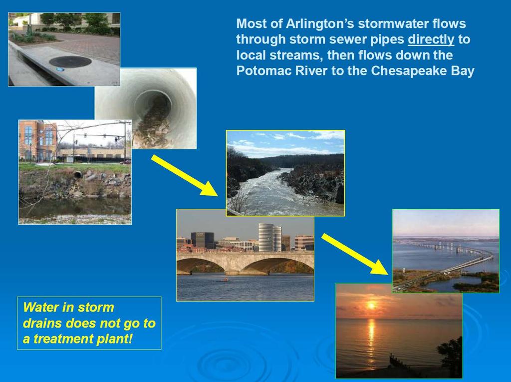
8 July 14, 2016 Parks Operations Bldg Environmental Background Stormwater and Streams
9 Outline Stormwater program overview Resource Protection Areas Floodplain Management Ordinance Stormwater Management Ordinance Illicit discharges and pollution hot spots Four Mile Run Restoration Master Plan 9


10 Arlington Stormwater Facts 220,400 people 26.5 square miles ~8,300 persons/square mile 42% impervious cover 370 miles of storm sewers 32 miles of perennial streams 44% tree canopy cover
11 11

12 Watershed boundaries ADD SW MAP Underground storm drain pipes Storm drain system 12


13 Water quality impacts from stormwater Stormwater runoff erodes local streams, carries sediment, nutrients, bacteria, petroleum, and litter downstream, kills trees, affects habitat for aquatic organisms, and damages sewer lines Sediment and nutrients are major pollutants of concern for Chesapeake Bay 13
14 Stormwater program goals Protect public health, safety, and property Reduce development impacts on water quality in local streams, the Potomac River, and the Chesapeake Bay Comply with state and federal regulations Municipal Separate Storm Sewer System (MS4) permit Chesapeake Bay cleanup requirements Floodplain management 14


15 Basic program elements Stormwater infrastructure Flood risk reduction Adding stormwater management for existing development Regulation of new development Stream restoration Pollution prevention for public and private activities Outreach, education, and monitoring 15

16 Stormwater Master Plan Adopted by County Board September 2014 Evaluates current state of stormwater management and condition of storm sewers, streams, and watersheds Provides comprehensive framework for managing stormwater, streams, and watersheds for next 20 years. Incorporates 3 technical needs assessment studies that identified priorities and led to current CIP project proposals: Stream inventory Watershed retrofit plans Storm sewer capacity analysis 16

17 MS4 permit and Chesapeake Bay cleanup requirements Major program driver with quantitative nutrient and sediment reduction requirements and regulatory deadlines Stormwater Master Plan and CIP provide strategy and funding MS4 permit also requires a broad range of programmatic and operational requirements to reduce stormwater pollution 17
18 18
19 Resource Protection Areas (RPAs) 19
20 Overview Established under Chesapeake Bay Preservation Ordinance 100 buffer from the banks of a stream (wider where steep slopes exist) Additional controls on development activity Goal is net stream buffer improvement in terms of vegetation and habitat Compatibility with streamside passive recreation and aesthetic and habitat improvements 20
21 Exceptions Process Exception required for projects that increase RPA encroachment or impervious area, or move structures closer to stream Chesapeake Bay Ordinance Review Committee reviews most exception requests associated with redevelopment in RPA Types of mitigation: Tree replacement or protection Overall vegetative enhancement Invasive plant removal/control Additional stormwater management measures Enhanced erosion control measures during construction 21
22
23 Floodplain Management Ordinance 23
24 Overview Residential development in or adjacent to FEMA designated 100-year floodplain must meet these requirements: Lowest level elevation must be one foot above 100-year flood elevation Footprint of structure must be at least 15 feet horizontally from floodplain Non-residential Meet above OR flood-proof structures. No encroachment in 100-year floodplain without analysis demonstrating no significant impact New flood data will be used to update map in study area ~5 years 24
25
26
27
28 Stormwater Management Ordinance 28
29 Overview Required by State in response to Chesapeake Bay cleanup requirements Arlington Stormwater Management Ordinance adopted by County Board effective July 1, 2014 Regulatory threshold is 2,500 SF of land disturbance Stormwater management compliance level of effort is driven by the increase in impervious cover for the project 29


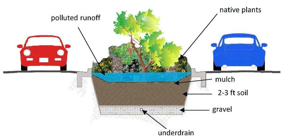
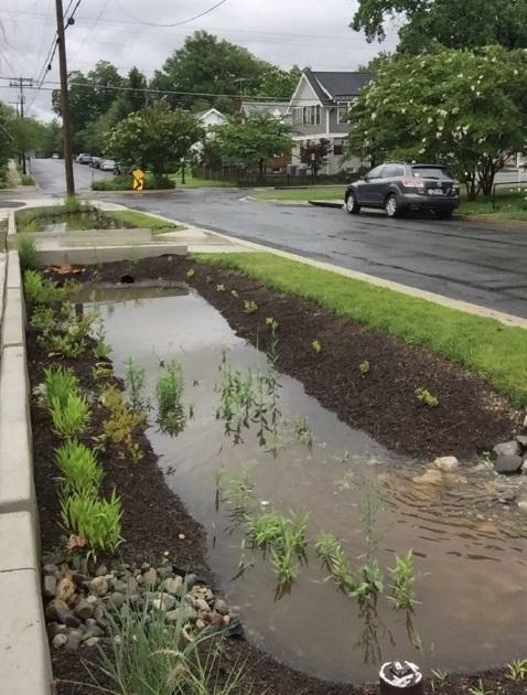
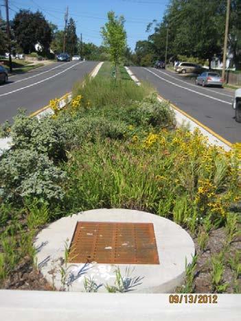
30 Performance standard summary 10% to 20% net pollutant load reduction. Protect downstream properties from increases in runoff volume Control construction impacts Typical compliance techniques include: Stormwater planters Bioretention Pervious pavements Underground filter systems Infiltration 30
31 Illicit discharges and pollution hot spots 31


32 Overview MS4 permit requires programs to address pollution incidents and potential pollution sources Combination of techniques, including inspections, monitoring, and technical assistance and outreach 32


33 Hot spot inspections Industrial and commercial facilities with high pollution potential Auto-related businesses and restaurant strips most common in Arlington Coordinate with multiple agencies to resolve issues and conduct enforcement Health Department, Fire Marshal Office, Code Enforcement, Solid Waste 33


34 Storm drain screening Includes S. Four Mile Run Drive area Collection of stormwater and dry weather samples Concentrated auto-related services contribute to petroleum pollution seen in stormwater runoff Larger road network also a major source 34
35 Challenges Existing, older development and site constraints Lack of awareness Incidents often occur after hours Turnover of property managers and/or tenants Limited enforcement authority Redevelopment of sites will provide much stronger opportunity and authority to address pollutant impacts. 35


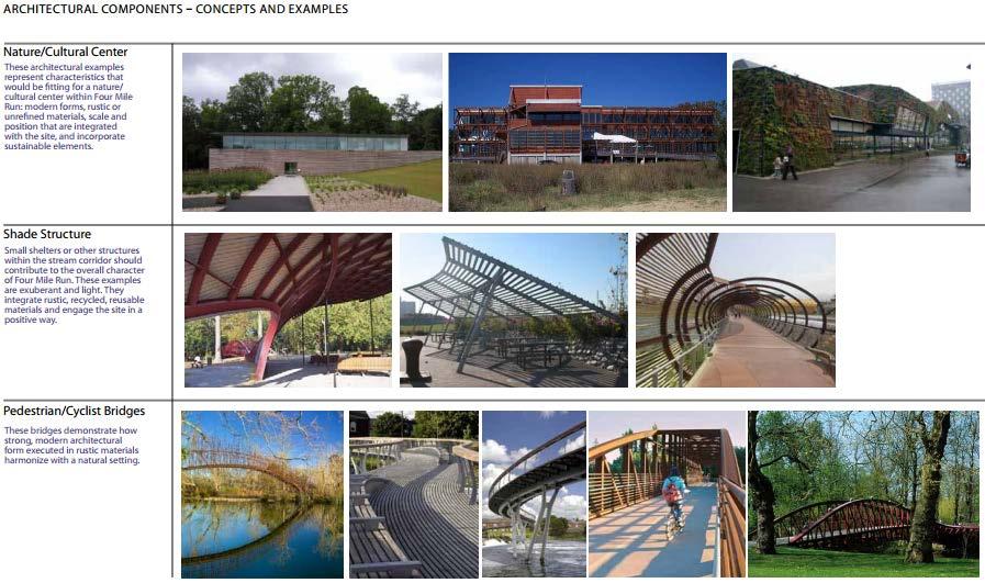
36 Pollution Prevention Targeted outreach to business community Educational materials and technical guidance Community meetings Collaboration between business community, civic associations, and County Outreach to public How to report illicit discharges and prevent pollution 36
37 37

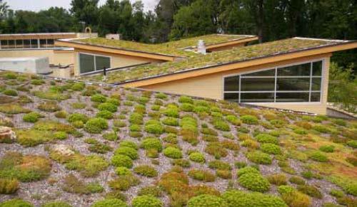
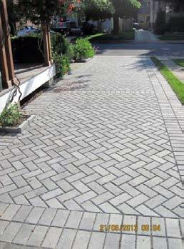
38 Four Mile Run Restoration Master Plan Adopted in

39 Four Mile Run 39

40 Overview Provides planning framework and vision for ecological restoration, aesthetic and recreational enhancements along lower Four Mile Run, extending upstream to the lower part of the study area. The principles of the plan can be applied throughout the study area. 40

41 Stream restoration principles Streambank naturalization and buffer enhancement Streamside pathways and overlooks In-stream habitat enhancements Educational interpretation Maintenance of flood capacity 41

42 Four Mile Run Design Guidelines Adopted in

43 Infrastructure Re-Use / Modern Rustic 43

44 Infrastructure Re-Use / Modern Rustic 44
45 Green infrastructure emphasis Bioretention (rain gardens) Pervious paving Green roofs 45
46 4MR Stream Restoration Bank naturalization: remove rip rap, terracing, living shorelines, invasive plant removal, native plantings Improved access: Viewing platform, re-build bike trail 46

47 4MR Stream Restoration Construction begins August/September 2016 Duration of 1 year Bike trail will be closed with detour through Alexandria 47

48 4MR Stream Restoration 48
49 49
50 50
51 Public Spaces Master Plan Update (POPS) o Planning Context o 2005 PSMP o POPS Schedule o Public Engagement Survey Results 51

52 PLANNING CONTEXT Arlington County Comprehensive Plan UPDATE Supporting Documents: CIP Sector Plans Area Plans Park Master Plans Neighborhood Conservation Plans, etc. Urban Forest Master Plan Public Art Master Plan Natural Resources Management Plan REFERENCE 52
53 2005 PSMP RECOMMENDATIONS Priority 3 - Emphasize Planning for Four Mile Run (Recommendation 1.3) o Complete the Four Mile Run Restoration Master Plan. o Develop the long-term land use plan for the Shirlington Crescent/Four Mile Run area. o In concert with the long-term overall plan, develop a master plan for the park land and visual and performing arts facilities between I-395 and Barcroft Park, including the existing Shirlington and Jennie Dean Parks and the five key, recently acquired parcels. The master plan should emphasize the development of the area as an important recreational, cultural and environmental resource. o Continue to acquire ownership or easements for land adjacent to both sides of Four Mile Run. 53
54 PROJECT SCHEDULE Analysis Input Site Evaluations Benchmarking Best Practices Public Meeting Series 1 Stakeholder Interviews Statistically Valid Survey Winter Spring Review Background Materials Community Needs Assessment Preliminary Recommendations Draft Plan Commissions + Board Reviews WE ARE HERE 54
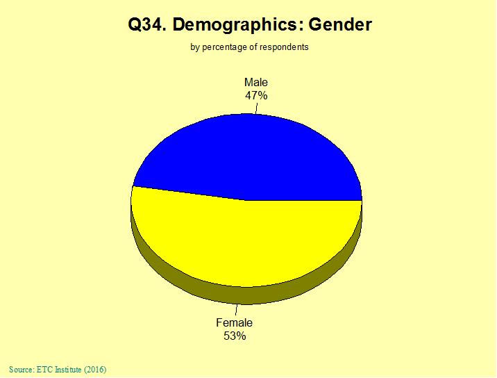
55 2016 Parks & Recreation Needs Assessment Survey 55

56 SURVEY OVERVIEW About 7 pages 24 public spaces questions 10 demographics questions Distribution Mailed after Thanksgiving Method of Administration By mail, phone and Internet Random sample of residents living in the County Results Target: 800 responses Actual: 1,470 responses Confidence level: 95% Margin of error: +/- 2.5% overall 56

57 Location of Survey respondents Good representation throughout the County 57


58 SURVEY RESULTS Demographics Demographics of survey respondents accurately reflects the actual population of the County 58

59 SURVEY RESULTS Demographics 59

60 SURVEY RESULTS Outdoor Facilities Households Have a Need for a Wide Range of Outdoor Facilities 60

61 SURVEY RESULTS Outdoor Facilities 61

62 SURVEY RESULTS Outdoor Facilities 62

63 SURVEY RESULTS Indoor Facilities 63

64 SURVEY RESULTS Indoor Facilities 64

65 SURVEY RESULTS Indoor Facilities 65

66 SURVEY RESULTS Programs + Activities Households Have a Need for a Wide Range of Programs and Activities 66

67 SURVEY RESULTS Programs + Activities 67

68 SURVEY RESULTS Programs + Activities 68
69 SURVEY REPORT The Survey Report and Cross Tabular Analysis are available at: 69
70 70
71 July 14, 2016 Parks Operations Bldg. Working Group Meeting #2 GLUP and Zoning Overview
72 Overview of Planning and Zoning Comprehensive Plan overview Background Administration Implementation General Land Use Plan overview History Amendments Supporting plans and documents Typical components of various plans Zoning overview History of zoning Arlington County Zoning Ordinance 4MRV Study Area General Land Use Plan designations Zoning districts 72
73 Comprehensive Plan Virginia Code requires all governing bodies to have an adopted Comprehensive Plan Guides the coordinated and harmonious development through public services and facilities Arlington County s Comprehensive Plan was established by resolution by the County Board in called for the preparation of five elements Today, there are 11 separate elements of the Comprehensive Plan Overall coordination of the Comprehensive Plan is within CPHD 73
74 Comprehensive Plan Each element of the Comprehensive Plan is administered by a specific agency: CPHD General Land Use Plan Planning Division Historic Preservation Master Plan Neighborhood Services Division Affordable Housing Master Plan Housing Division DPR Public Spaces Master Plan DES Master Transportation Plan Transportation Division Storm Water Master Plan Office of Sustainability and Environmental Management Water Distribution Master Plan DES Water, Sewers, Streets Bureau Sanitary Sewer Collection System Master Plan Water, Sewers, Streets Bureau Recycling Program Implementation Plan and Map Solid Waste Bureau Chesapeake Bay Preservation Plan and Ordinance Office of Sustainability and Environmental Management Community Energy Plan Office of Sustainability and Envir. Mgmt 74
75 Comprehensive Plan Implementation Zoning Ordinance and Map Subdivision Ordinance Capital Improvement Program 75


76 GLUP overview General Land Use Plan: Is the County s primary policy guide for future development Establishes the overall character, extent and location of various land uses Guides the County Board in decisions on future development Is one element of the County s Comprehensive Plan 76
77 GLUP overview History of the General Land Use Plan First GLUP adopted in August 1961 GLUP amendments incorporated into 11 published documents to date (1961, 1964, 1966, 1975, 1979, 1983, 1990, 1996, 2004, 2011) GLUP amendment map on-line is updated semiannually Amending the General Land Use Plan The GLUP may be amended to more clearly reflect the intended use for a particular area through three processes: As part of, or an implementation recommendation resulting from, a long-range planning process for a designated area (e.g. 4MRV study); or With a site plan or other development proposal (typically where consistent with recommendations in an adopted plan) As a result of a Special GLUP Study based upon an individual request (e.g. development proposal) 77
78 GLUP Overview Supporting Plans and Documents Sector Plans, Addenda, and Updates Courthouse Sector Plan Addendum: Courthouse Square (2015) Rosslyn Sector Plan (2015) Area Plans Columbia Pike Neighborhoods Area Plan (2012) North Quincy Street Plan Addendum (2013) Western Rosslyn Area Plan (2015) Revitalization Plans Columbia Pike Initiative A Revitalization Plan, Update 2005 Lee Highway/Cherrydale (1994) 78

79 GLUP Overview Typical Components of Various Plans Existing Conditions Analysis Vision and Goals/Concept Plan Policies/Elements of the Plan: o Land Use o Height o Open Space o Transportation/Parking o Urban Design Implementation Illustrative Plan Crystal City Sector Plan 79

80 GLUP overview 4MRV Study Area GLUP Designation Zoning Typically Associated with Designation Range of Density or Typical Use Public S-3A, S-D Parks, schools, parkways, major unpaved rightof-way, libraries and cultural facilities Service Industry CM, M-1, M-2 Wholesale, storage and light manufacturing, including those related to construction activity Service Commercial Medium Residential C-1-R, C-1, C-1-O, C-2, C-O-1.0 RA7-16, RA6-15, RA-H Personal and business services Up to dwelling units per acre 80
81 Zoning Overview Zoning is a land use regulatory tool developed in the early 20 th Century Rooted in the Police Powers of the United States Constitution New York City enacted the first zoning ordinance in the United States in 1916 Based on concept of separating land uses and regulating placement of structures on the lot Euclidean zoning (e.g. R-districts, C-1, C-2, M districts in Arlington) This model of zoning has evolved over the years to many different models, allowing for: Mixed-use zoning (e.g. Arlington s Metro corridors) Form Based Codes (e.g. Columbia Pike) Planned Unit Developments Cluster development 81
82 Zoning Overview Enabling authority for Arlington s Zoning Ordinance comes from the Code of Virginia Ordinance includes text and a map Arlington s first Zoning Ordinance was adopted April 26, 1930, based on a pyramid structure ZO Substantially amended in 1950 and
83 Zoning Overview Zoning Ordinance is one tool to implement the County s Master Plan As part of development of a plan in Arlington, it is typical to consider whether the Zoning Ordinance should be amended to implement the plan Arlington Zoning Ordinance includes 3 types of use allowances: By-right uses approved by Zoning Administrator when in compliance with the Ordinance provisions Special Exception uses: Use permit conditional uses, require approval by the County Board and may include conditions to mitigate impacts Site plan special exceptions, require Planning Commission and County Board approval, and used in Arlington to implement incentive zoning enabled by VA Code 83

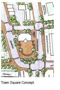
84 Zoning overview 4MRV Study Area 84
85 Zoning overview - public Zoning District S-3A Use Height Density SF Residential (P) 35 3 ac/lot Group homes (U) Public, civic and institutional uses Community service (community and recreation centers, libraries, museums, community pools, and similar) (P) Day care (U) Government facilities (fire and police stations) (P) Parks and open space (P) Passenger terminals and services (U) Religious institutions Schools (U) Major and minor utilities (U) Publicly-owned parking area Recycling and waste transfer Public, civic and institutional uses Colleges and universities (U) Hospitals (U) Social service institutions (U) Uses most typically found in this district are shown in red; P=by-right; U=use permit 45 n/a 45 5 ac/lot 85
 Public, civic and institutional uses* Retail, Office All industrial uses allowed in M-1, plus Heavy industrial uses:")
86 Zoning overview - industrial Zoning District M-1 M-2 Public, civic and institutional uses* Retail, office, hotel Industrial uses: Light industrial Manufacturing and production; Warehouse Wholesale trade Recycling and waste transfer, Heavy industrial uses: Concrete batching (U) Public, civic and institutional uses* Retail, Office All industrial uses allowed in M-1, plus Heavy industrial uses: Asphalt processing and manufacture (U) Wrecking and salvage yard (U) Concrete batching (P) Use Height Density FAR FAR Differences between M-1 and M-2 districts are shown in red; P=by-right; U=use permit * See S-3A for examples of public, civic and institutional uses 86
 Public, civic and institutional uses (U/P) Commercial, Office, Retail (U/P) Light industrial service (U/P) 45 1.5 FAR Hotel (P) 45 72.6 u/a Multifamily residential (P) 35 24.")
87 Zoning District C-2 RA-H RA7-16 RA8-18 Zoning overview - other Use Height Density (du/ac) Single family residential (P) du/ac Group living (U) Public, civic and institutional uses (U/P) Commercial, Office, Retail (U/P) Light industrial service (U/P) FAR Hotel (P) u/a Multifamily residential (P) du/ac Multifamily (P) Multifamily residential and hotel (S) Public, civic and institutional uses (U/P) Multifamily residential (P) Multifamily residential (S) Public, civic and institutional uses (U/P) Single-family residential (P) Two-family residential (P/S) Townhouse (P) Multifamily residential (P) Multifamily residential (S with ADU) Public, civic and institutional uses (U/P) 35 or 3½ stories 125 or 12 stories 95 or 10 stories 35 or 3½ stories 95 or 10 stories 95 or 10 stories 35 or 3 stories 35 or 3½ stories du/ac 72.6 du/ac n/a 24.2 du/ac 43.5 du/ac n/a 8.7 du/ac 12.4 du/ac 36.3 du/ac 36.3 du/ac 45 du/ac n/a 87
88 88
89 July 14, 2016 Parks Operations Bldg Working Group Meeting #2 Planning History
90 Industrial Land Use and Zoning Study (2000) This study focused attention on the area s potential for redevelopment in the face of waning industrial use The study found that the County no longer needs industrial uses* to perform successfully But, it also found that some industrial uses should potentially be preserved because of their value to the County Such uses could potentially be incorporated into non-industrial zoning districts through special exception processes with performance standards A major recommendation was to further study this area * However, additional consideration of the Concrete Batching Plant is warranted. 90
91 Nauck Village Center Action Plan The vision is for a mixed-use, pedestrian friendly environment centered around a town square bordered by 4-5 story buildings with retail on the ground floor/housing above To the north of the square, the scale of development would decrease with residential uses predominating To the south of the square, the scale of development would increase with a greater emphasis on mixed-use development Roadway elements address the needs of pedestrian, bicycle and vehicular traffic Urban design guidelines further the goal of an attractive and vibrant mixed-use environment 91

92 Nauck Village Center Action Plan (2004) Winner of a 2005 Virginia Chapter of the American Planning Association Award Plan was adopted as a revitalization plan for the commercial area of the Nauck neighborhood 92

93 Nauck Village Center Action Plan 93

94 GLUP GLUP Designation Zoning Typically Associated with Designation Range of Density or Typical Use Public S-3A, S-D Parks, schools, parkways, major unpaved right-of-way, libraries and cultural facilities Semi Public S-3A, S-D Countyclubs and semi-public recreational facilities. Church, private schools and private cemeteries. Service Industry Service Commercial Low Residential Low Residential Low Medium Residential Medium Residential Low Office- Apartment - Hotel Medium Office- Apartment - Hotel CM, M-1, M-2 C-1-R, C-1, C-1- O, C-2, C-O-1.0 R-20, R-10, R- 10T, R-8, R-6, R-5 R2-7, R15-30T R15-30T, RA14-26, RA8-18 RA7-16, RA6-15, RA-H C-O-1.5, C-O-1.0 C-O-2.5 Wholesale, storage and light manufacturing, including those related to construction activity Personal and business services 1-10 dwelling units/acre dwelling units/acre dwelling units/acre Up to dwelling units per acre Up to 1.5 FAR - commercial; 72 dwelling units/acre - residential; or 110 units/acre - hotel Up to 2.5 FAR - commercial; 115 dwelling units/acre - residential; or 110 units/acre - hotel 94


95 Nauck Village Center Action Plan 95

96 Nauck Village Center Action Plan Town Square Final Draft Design 96
97 Nauck Village Center Action Plan Approved Projects: Towns of Shirlington The Shelton The Macedonian 97

98 Shirlington Village PDSP Trades Center For illustrative purposes only 98
99 Shirlington Village PDSP PDSP = Phased Development Site Plan An overall development plan, encompassing several building sites under one ownership, that may be implemented over time. Typical Components: Building height, location, massing Overall density; use mix Street network Public open spaces Phasing plan 99
100 Shirlington Village PDSP GLUP: Low Office-Apartment-Hotel 1.5 FAR Commercial 72 units/acre residential 110 units/acre hotel Zoning: C Total Development: 1,049 residential units 432,566 sf retail, including grocery store 585,111 sf office 57,000 sf library and theater 142 hotel rooms 100
Working Group Meeting
 April 4,, 2017 Parks Operations Bldg Working Group Meeting Arts Districts Overview Stormwater/RPA/Stream Considerations First Principles Agenda 7:00pm 7:05pm 7:10pm 7:40pm 8:30pm 9:40pm 9:45pm Welcome
PLANNING IN ARLINGTON. Briefing to Katie Cristol
 1 PLANNING IN ARLINGTON Briefing to Katie Cristol Overview 2 Comprehensive Plan - Background Administration of the Comprehensive Plan Review of the Comprehensive Plan Implementation of the Comprehensive
Arlington Joint Facilities Advisory Commission Buck Subcommittee. February 22, 2017
 Arlington Joint Facilities Advisory Commission Buck Subcommittee February 22, 2017 1 Agenda 7:00 Welcome and Introductions 7:10 Work Plan 7:20 Overview of Land Swap 7:40 4MRV Area Plan 8:00 Site Characteristics
FOUR MILE RUN VALLEY WORKING GROUP AND CHARGE
 FOUR MILE RUN VALLEY WORKING GROUP AND CHARGE Adopted April 16, 2016 Amended July 19, 2016 Overview of Integrated Effort The overall goal of the Four Mile Run Valley (4MRV) initiative is to develop a comprehensive
FOUR MILE RUN VALLEY WORKING GROUP AND CHARGE Adopted April 16, 2016 Amended July 19, 2016
 FOUR MILE RUN VALLEY WORKING GROUP AND CHARGE Adopted April 16, 2016 Amended July 19, 2016 Working Group Charge The Working Group is charged by the County Board to collaborate with staff to provide commission,
Arlington, Virginia is a worldclass
 EXECUTIVE S U M M A RY Arlington maintains a rich variety of stable neighborhoods, quality schools and enlightened land use policies, and received the Environmental Protection Agency s highest award for
Arlington County Long Range Planning Committee Meeting
 Arlington County Long Range Planning Committee Meeting Preliminary FY2015 Planning Division Work Program A presentation by the Arlington County Department of Community Planning, Housing and Development,
ARLINGTON COUNTY, VIRGINIA. County Board Agenda Item Meeting of June 16, 2018
 ARLINGTON COUNTY, VIRGINIA County Board Agenda Item Meeting of June 16, 2018 DATE: June 7, 2018 SUBJECT: Z-2604-18-1 Rezoning from R-6 and R-5 Single Family Residential Districts to S-3A Special District
County Board Meeting October 20, Request to Advertise Draft Area Plan
 County Board Meeting October 20, 2018 Request to Advertise Draft Area Plan Park & Recreation Commission Meeting October 23, 2018 Outline Study Area & Process Milestones Area Plan Elements Key Policy Recommendations
2.7 ac park. TOTAL 5,403 DU 1,297,900 sf 1,105,450 sf 3.87 ac 5,563 DU 1,121,200 sf 1,105,450 sf 3.87 ac
 PLAN AMENDMENT 2013-I-B1: SEVEN CORNERS SPECIAL STUDY Summary of Pre-staffing Comments Planner: Bernard Suchicital bsuchi@fairfaxcounty.gov (703) 324-1254 Background On October 29, 2013, the Board of Supervisors
Watershed Planning Workshop
 Watershed Planning Workshop Upper Four Mile Run, Gulf Branch and Donaldson Run March 18, 2010 Langston Brown Community Center Outline Overview of Arlington s s Watersheds Watershed Management in Arlington
Chapter 3 Site Planning and Low Impact Development
 CHAPTER 3 Site Planning and Low Impact Development Chapter 3 Site Planning and Low Impact Development 3.0 Introduction The City of Charleston requires that major residential, large commercial (>1 acre),
Gold Line Bus Rapid Transit Transit Oriented Development (BRTOD) Helmo Station Area Plan
 Helmo Station Area Plan") Appendix F Gold Line Bus Rapid Transit Transit Oriented Development (BRTOD) Helmo Station Area Plan Introduction and Purpose of the Plan The Gold Line Bus Rapid Transit facility is an eleven-mile dedicated
Appendix F Gold Line Bus Rapid Transit Transit Oriented Development (BRTOD) Helmo Station Area Plan Introduction and Purpose of the Plan The Gold Line Bus Rapid Transit facility is an eleven-mile dedicated
Town of Peru Comprehensive Plan Executive Summary
 Town of Peru Comprehensive Plan Executive Communities that plan grow by choice, not by chance. A plan makes growth thoughtful, understandable, and predictable. A plan shows that a community is managing
POPS Advisory Committee Meeting May 31, 2018
 POPS Advisory Committee Meeting May 31, 2018 NOTE: This presentation is a working document, and some recommendations or ideas may have evolved or changed based on continued discussions and additional analyses.
Courthouse Square Implementation Comment/Response Matrix
 Courthouse Square Implementation /Response Matrix 1 Are open space symbols binding? GLUP No, open space symbols are not binding, as the GLUP is a policy instrument illustrating the County s future vision
SECTION II SECTION II STATEMENT OF GOALS, OBJECTIVES, PRINCIPLES, ASSUMPTIONS, POLICIES AND STANDARDS
 STATEMENT OF GOALS, OBJECTIVES, PRINCIPLES, ASSUMPTIONS, POLICIES AND STANDARDS 1 2 STATEMENT OF GOALS, OBJECTIVES, PRINCIPLES, ASSUMPTIONS, POLICIES AND STANDARDS INTRODUCTION The New Jersey Municipal
Silver Line CPAM UPDATE. Transportation and Land Use Committee October 14, 2016
 Silver Line CPAM UPDATE Transportation and Land Use Committee October 14, 2016 Purpose Recap Project History and Map Changes Provide Overview of CPAM Components Discuss Transportation Impacts Discuss Fiscal
ARLINGTON COUNTY, VIRGINIA
 ARLINGTON COUNTY, VIRGINIA County Board Agenda Item Meeting of September 19, 2015 DATE: September 11, 2015 SUBJECTS: Outdoor Café at Citizen Burger Bar A. SP# 418 Site Plan Amendment to modify an approved
Description of Preferred Alternative
 Chapter 2 Description of Preferred Alternative 2.1 Introduction This chapter of the programmatic Sammamish Town Center Sub-area Plan Final EIS provides a more detailed description of the Preferred Alternative
ARLINGTON COUNTY, VIRGINIA
 ARLINGTON COUNTY, VIRGINIA County Board Agenda Item Meeting October 15, 2005 DATE: September 28, 2005 SUBJECT: Request to Advertise the adoption of the 2005 Clarendon Sector Plan C. M. RECOMMENDATION:
Water in storm drains does not go to a treatment plant
 Watershed Planning Workshop Upper Mainstem & Middle Four Mile Run November 30, 2011 Fairlington Community Center Arlington s watersheds Chesapeake Bay watershed Watershed Planning Initiated May 2008 Contracted
PUBLIC SPACES MASTER PLAN UPDATE (POPS) Joint Facilities Advisory Commission (JFAC) November 28, 2018
 Joint Facilities Advisory Commission (JFAC) November 28, 2018") PUBLIC SPACES MASTER PLAN UPDATE (POPS) Joint Facilities Advisory Commission (JFAC) November 28, 2018 1 AGENDA POPS Planning Context Timeline Public Input Final POPS Draft Next Steps 2 PLANNING CONTEXT
PUBLIC SPACES MASTER PLAN UPDATE (POPS) Joint Facilities Advisory Commission (JFAC) November 28, 2018 1 AGENDA POPS Planning Context Timeline Public Input Final POPS Draft Next Steps 2 PLANNING CONTEXT
CITY OF CHARLOTTESVILLE, VIRGINIA CITY COUNCIL AGENDA
 CITY OF CHARLOTTESVILLE, VIRGINIA CITY COUNCIL AGENDA Agenda Date: December 16, 2013 Action Required: Adoption of Resolution Presenter: Staff Contacts: Title: James E. Tolbert, AICP, Director of NDS James
Secrest Short Cut and Monroe Expressway Small Area Plan AUGUST 29, 2018
 Secrest Short Cut and Monroe Expressway Small Area Plan AUGUST 29, 2018 Background and Process Monroe Expressway will be open by the end of 2018 Union County and Indian Trail identified a need to revisit
STORMWATER MANAGEMENT CODES ANALYSIS RICHLAND COUNTY, SC SITE PLANNING ROUNDTABLE
 STORMWATER MANAGEMENT CODES ANALYSIS RICHLAND COUNTY, SC SITE PLANNING ROUNDTABLE Codes analyses for each subcommittee were completed to assist participants of the Richland County Site Planning Roundtable.
ARLINGTON COUNTY, VIRGINIA. County Board Agenda Item Meeting of September 22, 2018
 ARLINGTON COUNTY, VIRGINIA County Board Agenda Item Meeting of September 22, 2018 DATE: September 13, 2018 SUBJECT: Four Mile Run Valley (4MRV) Park Master Plan and (associated) Design Guidelines. C. M.
Floyds Fork Area Study Project Overview, Suitability Analysis, & Form Districts July 29, title
 Floyds Fork Area Study Project Overview, Suitability Analysis, & Form Districts July 29, 2008 Agenda Floyds Fork Area Study Project overview and purpose Process and schedule Ongoing initiatives Floyds
ARLINGTON COUNTY, VIRGINIA. County Board Agenda Item Meeting of April 21, 2018 SUPPLEMENTAL REPORT
 ARLINGTON COUNTY, VIRGINIA County Board Agenda Item Meeting of April 21, 2018 SUPPLEMENTAL REPORT DATE: April 18, 2018 SUBJECT: Request to authorize advertisement of public hearings by the Planning Commission
Weston s Wetlands, Stormwater, & Open Space
 Weston s Wetlands, Stormwater, & Open Space Weston s Wetlands, Stormwater, & Open Space Conservation Commission Role and Responsibilities Laws that protect wetlands What residents can do to protect wetlands
The Benefits and Challenges Associated with Green Infrastructure Practices
 The Benefits and Challenges Associated with Green Infrastructure Practices Thomas M. Evans ASLA, LEED AP Regional Green Infrastructure Design Services Director OWEA Technical Conference, June 20, 2013
The Vision. Photo provided by The Minervini Group. 46 Vision, Objectives & Strategies
 Vision, Objectives & Strategies The is the public framework and guide for future development of the Grand Traverse Commons. The establishes public polices for infrastructure, the preservation of natural
BROOKHILL NEIGHBORHOOD MODEL ZONING MAP AMENDMENT PREFACE TO APPLICATION
 BROOKHILL NEIGHBORHOOD MODEL ZONING MAP AMENDMENT PREFACE TO APPLICATION June 15, 2015 Revised: August 1, 2016 I. VISION Brookhill is a proposed community based upon the principles of Albemarle County
DRAFT. Urban Development Areas Fairfax County. UDA Needs Profile: Tysons Corner 13% Location Characteristics. Socio-Economic Characteristics
 14 Urban Development Areas Fairfax County UDA Needs Profile: Tysons Corner Tysons Corner is located in Fairfax County, surrounded by the town of McLean to the east and Vienna on the west along I-495, the
SAN RAFAEL GENERAL PLAN 2040 INTRODUCTION AND OVERVIEW
 SAN RAFAEL GENERAL PLAN 2040 INTRODUCTION AND OVERVIEW Steering Committee Presentation February 14, 2018 Purpose of General Plan Guide land use and development decisions Coordinate transportation, infrastructure,
3. VISION AND GOALS. Vision Statement. Goals, Objectives and Policies
 Vision Statement Queen Creek s interconnected network of parks, trails, open spaces and recreation opportunities provide safe and diverse activities and programs that sustain its unique, small town, equestrian
STREAM BUFFERS
 88-415 STREAM BUFFERS 88-415-01 PURPOSE In the Kansas City region and throughout the nation, vegetated stream buffers have been clearly shown to protect stream stability and related infrastructure, improve
S C O P E O F W O R K A P R I L
 white flint 2 sector plan S C O P E O F W O R K A P R I L 2 0 1 2 MONTGOMERY COUNTY PLANNING DEPARTMENT M-NCPPC MontgomeryPlanning.org 1 white flint 2 sector plan Scope of Work abstract This scope of work
ARTICLE 6: Special and Planned Development Districts
 ARTICLE 6: Special and Planned Development Districts 6-10 Traditional Neighborhood Development (TND) District 6-10.10 Purpose and Intent The Traditional Neighborhood Development (TND) District provides
CHAPTER 1. Ms. Guajardo s Class - Central Elementary CH 1 1
 INTRODUCTION CHAPTER 1 Ms. Guajardo s Class - Central Elementary CH 1 1 1.1 SETTING South Centre City is a linear corridor south of Downtown Escondido paralleling Centre City Parkway and South Escondido
3.10 LAND USE SETTING PROJECT SITE EXISTING LAND USE DESIGNATIONS AND ZONING. General Plan Land Use Designations.
 This section of the Draft EIR addresses the existing land uses on and adjacent to the project site and discusses the potential impacts of the proposed project on existing land uses. Key issues addressed
Westwood Shopping Center Sketch Plan, Plan # February 23, 2017 Item # 9
 Westwood Shopping Center Sketch Plan, Plan # 320170010 February 23, 2017 Item # 9 Westwood II Site 64,111 s.f. Manor Care site: vacant two story building HOC-Westwood Towers, 15 story tower To be considered
Three threshold measures will be applied together to capture project scale and scope and impacts:
 The regulatory consequences to the County from State and Federal water quality regulations if the pollution impacts are not addressed by each project. The extreme difficulty, cost, and equity issues associated
A BLUEPRINT FOR BROCKTON A CITY-WIDE COMPREHENSIVE PLAN
 A BLUEPRINT FOR BROCKTON A CITY-WIDE COMPREHENSIVE PLAN Public Meeting October 2016 1 Plan Summary and Discussion Public Meeting May 4 2017 City of Brockton Bill Carpenter, Mayor Department of Planning
TO: FROM: SUBJECT: Background
 TO: FROM: SUBJECT: Long Range Planning Committee and Zoning Committee of the Planning Commission Kellie Brown and Margaret Rhodes, Planning Division, CPHD DATE: June 8, 2017 Courthouse Square Implementation
INTRODUCTION PLANNING HISTORY
 INTRODUCTION The Upper Rock Creek Master Plan Area lies in the east central part of Montgomery County. The Master Plan Area is adjacent to the City of Rockville to the south, the Olney Planning Area to
Municipal Plan*Assessment
 Municipal Plan*Assessment This tool was developed to assist in reviewing municipal master plans and in determining if these plans are consistent with smart growth principles, neighboring municipal plans,
Ten Mile Creek Planning Area
 PLANNING AREA POLICIES TEN MILE CREEK Ten Mile Creek Planning Area Location and Context The Ten Mile Creek Planning Area ( Ten Mile Creek area ) is located south of the current Boise AOCI, generally south
ARLINGTON COUNTY, VIRGINIA. County Board Agenda Item Meeting of February 23, 2019
 ARLINGTON COUNTY, VIRGINIA County Board Agenda Item Meeting of February 23, 2019 DATE: February 15, 2019 SUBJECT: Amendment to the Master Transportation Plan (MTP) Map to add a new section of North Kansas
Arlington County Retail Plan
 Arlington County Retail Plan Draft April 28, 2015 EXECUTIVE SUMMARY Arlington will be a community where retail is convenient, appealing, activating and sustainable; that provides interest and authenticity,
COMMUNITY DESIGN. GOAL: Create livable and attractive communities. Intent
 COMMUNITY DESIGN Intent An attractive, well-designed County will attract quality development, instill civic pride, improve the visual character of the community, and create a strong, positive image for
Town of Washington Master Plan & Regulatory Audit: Interim Results
 Town of Washington Master Plan & Regulatory Audit: Interim Results May 20, 2008 Presented by: 30 Bank Street Lebanon, NH 03766 www.uvlsrpc.org Introduction & Purpose Compare the Master Plan to the regulations
Stafford County Strategic Plans
 Stafford County Strategic s Strategic Department Description Date Adopted Board of Supervisors Priorities Fiscal Responsibility Education Public Safety Infrastructure Economic Development Service Excellence
ARLINGTON COUNTY, VIRGINIA
 ARLINGTON COUNTY, VIRGINIA County Board Agenda Item Meeting of April 12, 2014 DATE: April 2, 2014 SUBJECT: to the Arlington County Zoning Ordinance, Article 11.1 "CP-FBC" Columbia Pike Form Based Code
Draft Memorandum #1: Goals and Vision for Revitalization
 Keizer Revitalization Plan Draft Memorandum #1: Goals and Vision for Revitalization Submitted to: City of Keizer April 12, 2018 (revised) Prepared By: Angelo Planning Group and Otak, Inc. Project No. 17482.A
Can Urban Redevelopment Restore Aquatic Resources
 Can Urban Redevelopment Restore Aquatic Resources with Standards for Stormwater Retention and Landscape Performance? Rebecca C. Stack District of Columbia Department of the Environment Industry, Agriculture,
ST. MARY S SOIL CONSERVATION DISTRICT (SMSCD) AND DPW&T CONCEPT EROSION AND SEDIMENT CONTROL AND STORMWATER MANAGEMENT GUIDELINES AND CHECKLIST
 AND DPW&T CONCEPT EROSION AND SEDIMENT CONTROL AND STORMWATER MANAGEMENT GUIDELINES AND CHECKLIST") St. Mary s Soil Conservation District 26737 Radio Station Way, Suite B Leonardtown, MD 20650 Phone: 301-475-8402 ext. 3 Fax: 301-475-8391 www.stmarysscd.com St. Mary s County Government Department of Public
St. Mary s Soil Conservation District 26737 Radio Station Way, Suite B Leonardtown, MD 20650 Phone: 301-475-8402 ext. 3 Fax: 301-475-8391 www.stmarysscd.com St. Mary s County Government Department of Public
Planning Charlotte s Future. Planning Committee May 17, 2016
 Planning Charlotte s Future Planning Committee May 17, 2016 Place Types: Next Steps March - June Public Input: Education & input on community character and place-type framework Public open house (Transportation
Throughout. square. (Crystal City Vision Plan 2050)
") 1: Terms related to the PSMP document 1 public space (see also public realm, civic space) An open space designated on the regulating plan, accessible to all, including Plazas, Mini Parks, and Neighborhoods
1: Terms related to the PSMP document 1 public space (see also public realm, civic space) An open space designated on the regulating plan, accessible to all, including Plazas, Mini Parks, and Neighborhoods
Toronto Complete Streets Guidelines
 Toronto Complete Streets Guidelines 108 110 7.1 Green Infrastructure Design Principles 112 7.2 Context-Sensitive Green Streets 114 7.3 Key Green Street Elements Green infrastructure refers to natural and
RECREATION AND OPEN SPACE ELEMENT GOALS, OBJECTIVES, AND POLICIES
 RECREATION AND OPEN SPACE ELEMENT GOALS, OBJECTIVES, AND POLICIES Goal 7 To provide park facilities, recreation programs, and open space resources that are safe, adequate, and accessible to all City residents,
HAZARD MITIGATION GOALS AND OBJECTIVES
 SEWRPC Community Assistance Planning Report No. 282, 2nd Edition CITY OF MILWAUKEE ALL HAZARDS MITIGATION PLAN UPDATE Chapter IV HAZARD MITIGATION GOALS AND OBJECTIVES [NOTE: Throughout this plan update
PLANNED UNIT DEVELOPMENT & SUBDIVISION STAFF REPORT Date: May 18, 2017
 & PUD-0000102-2017 PLANNED UNIT DEVELOPMENT & SUBDIVISION STAFF REPORT Date: May 18, 2017 NAME SUBDIVISION NAME Dauphin Creek Estates Subdivision Dauphin Creek Estates Subdivision LOCATION CITY COUNCIL
Introduction. Chapter 1. Purpose of the Comprehensive Plan Plan Organization Planning Process & Community Input 1-1
 Chapter 1 Introduction Lakewood 2025: Moving Forward Together Purpose of the Comprehensive Plan Plan Organization Planning Process & Community Input 1-1 Purpose of the Comprehensive Plan The Comprehensive
Implementation Vision
 Introduction The implementation chapter is the how to portion of the plan. It describes the actions necessary to realize the visions presented in this document through the goals, objectives, and policies
Implementation Guide Comprehensive Plan City of Allen
 Implementation Guide 2030 Comprehensive Plan City of Allen DRAFT 2015 Implementation Guide Allen 2030 Comprehensive Plan INTRODUCTION The Comprehensive Plan serves as a guide for the growth and development
4MRV Policy Framework Comments from Shirlington Submitted February 6, 2018
 4MRV Policy Framework Comments from Shirlington Submitted February 6, 2018 Dear Richard, Scott and 4MRV Team, Thank you for circulating the draft 4MRV Policy Framework in advance of the Feb. 6th meeting.
Land Use Amendment in Southwood (Ward 11) at and Elbow Drive SW, LOC
 at and Elbow Drive SW, LOC") 2018 November 15 Page 1 of 10 EXECUTIVE SUMMARY This land use amendment application was submitted by Rick Balbi Architect on 2017 August 31 on behalf of Sable Developments Ltd, and with authorization from
2018 November 15 Page 1 of 10 EXECUTIVE SUMMARY This land use amendment application was submitted by Rick Balbi Architect on 2017 August 31 on behalf of Sable Developments Ltd, and with authorization from
July 23, 2014 Wilson School. Working Group Meeting #3 Preliminary Site Analysis School Siting Considerations Guiding Principles
 July 23, 2014 Wilson School Working Group Meeting #3 Preliminary Site Analysis School Siting Considerations Guiding Principles Agenda Follow-Up from Meeting #2: WG & community feedback Presentations /
City of Petersburg, VA Stormwater Utility Frequently Asked Questions
 Q. What is stormwater runoff? A. Stormwater runoff is the water that flows off roofs, driveways, parking lots, streets and other hard surfaces during rain storms. Stormwater runoff is also the rain that
Stormwater Management Guidance Manual: Customizing and optimizing stormwater requirements for port-specific land uses and customers.
 Stormwater Management Guidance Manual: Customizing and optimizing stormwater requirements for port-specific land uses and customers. June 30, 2016 Port of Tacoma Environmental Project Manager: Anita Fichthorn
Parks, Open Space and Trails
 Introduction Parks have often been referred as the lungs of our cities, cleansing the air of pollutants and particulate matter. Parks are also gathering places for families and community. They offer spaces
PORT WHITBY COMMUNITY
 PORT WHITBY COMMUNITY SECONDARY PLAN UPDATE COMMUNITY IMPROVEMENT PLAN URBAN DESIGN GUIDELINES September 2015 DRAFT PROPOSED AMENDMENT NUMBER # to the Whitby Official Plan PURPOSE: The intent of this Amendment
Sorted citizen input comments in review of Blount County plans July, August, and September 2007
 Sorted citizen input comments in review of Blount County plans July, August, and September 2007 The following presents sorted citizen input comments from three sessions held in July, August and September
2018 Northampton Township Comprehensive Plan
 2018 BUCKS COUNTY, PENNSYLVANIA What is a? A comprehensive plan is a municipality s main policy document that details the collective vision for the future, the historic, environmental, and cultural facilities
COMPLETE GREEN STREET CHECKLIST
 COMPLETE GREEN STREET CHECKLIST This document was developed to dissect the structure of an urban street and explore opportunities to make our streets more complete while also integrating green street strategies.
DRAFT Land Use Chapter
 Stevens Creek Urban Village DRAFT 1 18 17 Land Use Chapter INTRODUCTION This Land Use Chapter describes how the Stevens Creek Urban Village will accommodate the growth that is planned for it in the Envision
LAND USE ELEMENT. Purpose. General Goals & Policies
 LAND USE ELEMENT Purpose This Land Use Element contains the goals and policies necessary to support the City s responsibility for managing land resources and guiding development through implementing regulations,
LAND USE AMENDMENT DOWNTOWN COMMERCIAL CORE (WARD 7) MACLEOD TRAIL SE AND 5 AVENUE SE BYLAW 254D2017
 MACLEOD TRAIL SE AND 5 AVENUE SE BYLAW 254D2017") Page 1 of 10 EXECUTIVE SUMMARY This Land Use Amendment application seeks to redesignate a full downtown block (currently the YWCA site) from a Direct Control based on the CM-2 District (Land Use Bylaw
Page 1 of 10 EXECUTIVE SUMMARY This Land Use Amendment application seeks to redesignate a full downtown block (currently the YWCA site) from a Direct Control based on the CM-2 District (Land Use Bylaw
ARLINGTON COUNTY, VIRGINIA
 ARLINGTON COUNTY, VIRGINIA County Board Agenda Item Meeting of March 10, 2012 DATE: February 29, 2012 SUBJECT: SP #197 SITE PLAN AMENDMENT to add a new condition #25 to allow a new use for a Yoga and Pilates
Staff will be providing an overview of the project need, purpose and intent for consideration as part of the Amendment cycle.
 Agenda Item D-2 City of Tacoma Planning and Development Services To: Planning Commission From: Stephen Atkinson, Planning Services Division Subject: Open Space Corridors Project Meeting Date: March 1,
10 Implementation. Implementation. Responsibility for Implementation. Blueprint for Bloomsburg. Town of Bloomsburg Comprehensive Plan 10-1
 Implementation 10 Implementation This chapter overviews how to use the comprehensive plan as a land use and programming tool for the Town of Bloomsburg and recommends annual review of the plan by the Town
Citywide Integrated Stormwater Management Plan (ISMP) DRAFT ACTION PLAN REVIEW Public Consultation November 16 th, 2016
 DRAFT ACTION PLAN REVIEW Public Consultation November 16 th, 2016") Citywide Integrated Stormwater Management Plan (ISMP) DRAFT ACTION PLAN REVIEW Public Consultation November 16 th, 2016 1 Agenda DRAFT ACTION PLAN REVIEW Public Consultation Time 6:00 6:05 6:05 6:20 6:20
Citywide Integrated Stormwater Management Plan (ISMP) DRAFT ACTION PLAN REVIEW Public Consultation November 16 th, 2016 1 Agenda DRAFT ACTION PLAN REVIEW Public Consultation Time 6:00 6:05 6:05 6:20 6:20
Ridgefield and the Growth Management Act
 1 2 Ridgefield and the Growth Management Act 3 Why Do We Plan History of Planning in Ridgefield Washington experiences rapid growth in the late 1980 s that began to change the perceived quality of life.
December 23, Rezoning #PLN , Hoadly Falls Phase II Occoquan Magisterial District
 COUNTY OF PRINCE WILLIAM 5 County Complex Court, Prince William, Virginia 22192-9201 PLANNING (703) 792-6830 Metro 631-1703, Ext. 6830 FAX (703) 792-4401 OFFICE Internet www.pwcgov.org Christopher M. Price,
2035 General Plan Update and Belmont Village Specific Plan. Joint Study Session with the City Council and Planning Commission April 12, 2016
 2035 General Plan Update and Belmont Village Specific Plan Joint Study with the City Council and Planning Commission April 12, 2016 Agenda 1. Welcome and Introductions 2. General Plan Update Status of
Living in Albemarle County s Urban Places
 Living in Albemarle County s Urban Places ALBEMARLE COUNTY, VIRGINIA A Closer Look at Albemarle s Approach to Managing Growth and Creating Quality Urban Environments www.albemarle.org Page 2 Living in
26/Old Dominion Task Force
 26/Old Dominion Task Force Meeting #9: March 21, 2019 Study Area Overview Staff Name, Department (DEPT ACRONYM) Preferred Scenarios Outline 1. Task Force Feedback from 3/7 2. Refined Concepts 3. Implementation
Chesapeake Bay Critical Area Conservation Plan
 The Maryland-National Capital Park and Planning Commission Prince George s County Planning Department Development Review Division 301-952-3530 Note: Staff reports can be accessed at www.mncppc.org/pgco/planning/plan.htm.
40 Years of Smart Growth Arlington County s Experience with Transit Oriented Development in the Rosslyn-Ballston Metro Corridor
 40 Years of Smart Growth Arlington County s Experience with Transit Oriented Development in the Rosslyn-Ballston Metro Corridor A presentation by the Arlington County Department of Community Planning,
Agenda. Background Review of public process Recent project activities Current Status Next steps for construction
 January 30, 2019 Agenda Background Review of public process Recent project activities Current Status Next steps for construction Pond Background The pond was initially built as a dry pond to collect stormwater
THE 355/270 CORRIDOR:
 THE 355/270 CORRIDOR: Strategic Ideas for Sustaining a Livable Work Place Project Summary ACCESS LIFE DESIGN HEALTH WORK Montgomery County Planning Department The Maryland-National Capital Park and Planning
Scorecard. WaterQuality. Appendix B USEPA WATER QUALITY SCORECARD APPENDIX B
 Appendix B USEPA WATER QUALITY SCORECARD EPA 231B09001 October 2009 http://www.epa.gov WaterQuality Scorecard Incorporating Green Infrastructure Practices at the Municipal, Neighborhood, and Site Scales
Master Plan Objectives and Policies
 Master Plan Objectives and Policies Introduction This chapter identifies the Park issues and recommended policies established by this Master Plan. The issues were identified through meetings with staff,
Stormwater Regulations & Considerations Morse Study Area. Pam Fortun, P.E. CFM Senior Stormwater Treatment Engineer Engineering Services Division
 Stormwater Regulations & Considerations Morse Study Area Pam Fortun, P.E. CFM Senior Stormwater Treatment Engineer Engineering Services Division Stormwater Regulations Development Considerations Floodplain
Red Fox Commercial Outline Plan
 Red Fox Commercial Outline Plan City of Cold Lake, Alberta Prepared by Durrance Projects Ltd and Ross W. Sharp & Associates Ltd October 2014 Rupert 1 Table of Contents 1. PURPOSE...3 1.1. Location...4
Green Infrastructure Planning Design Guidelines
 A resource for planning boards in Monroe County September 2016 Green Infrastructure Planning Design Guidelines September 2016 Jayme Breschard Thomann, AICP, CFM David Zorn, Executive Director Genesee/Finger
Westbound: A One-day Exploration of Growth
 Westbound: A One-day Exploration of Growth Frog Pond Area 2018 UGB Expansion Proposal June 13, 2018 Growing Out: UGB Asks Four cities submitted proposals to expand greater Portland s urban footprint by
Seattle s Natural Drainage Systems and Complete Streets
 Seattle s Natural Drainage Systems and Complete Streets NACTO Designing Cities 2016 Outline Set stage Seattle and systems How Seattle has utilized bioretention to protect water systems Pathways for project