(Note: bold typing indicates sections that have been added or modified from the currently adopted Design Guidelines.)
|
|
|
- Vivien Mitchell
- 6 years ago
- Views:
Transcription
1 Draft July 31, Multifamily (Note: bold typing indicates sections that have been added or modified from the currently adopted.) The purpose of this chapter is to provide planning and design guidelines for multifamily development that supports those goals and objectives of the County general plan that provide for residential development that is a positive addition to the community. The multifamily design guidelines and standards apply to all residential projects of eight dwelling units per acre and greater. This wide range of attached and detached housing products, include apartments, townhomes, and small lot single-family projects. The small-lot single-family guidelines are supplemented by the standards in Chapter 2.0. The process for using these design guidelines is to; A. Determine the Community Context and Housing Category Type (3.1) B. Respond to Site Design standards (3.2) C. Apply the Building Design Standards (3.3) D. Apply the Landscape/Site Elements Design standards (3.4) 3.1 Context and Housing Types It is the intent of these multi-family design guidelines to support multi-family development that is consistent with the applicable provisions of the Sacramento County General Plan. A major goal of these design guidelines is to help new multifamily development be context sensitive and fit within the surrounding community, both existing and proposed. The following sections illustrate the process to be used to determine the Community Context that applies to a development site and the appropriate Housing Type for use on it. It is important to recognize that the County of Sacramento contains diverse communities and undeveloped areas that vary in character from rural to urban Community Context Types Knowing the existing zoning of the surrounding community is a simple step in determining the community context type of the site. This section outlines the process of determining the community context type and the eventual multifamily development category that may be appropriate within each predominant community context. Step 1: Identify the Community Context Type 1

2 Three major community context types for purposes of evaluating multifamily projects have been identified in Sacramento County. Community Context Type A consists of small agricultural communities of predominantly large and small rural residential lots, agricultural parcels, and some smaller scale agricultural related retail uses. Community Context Type B consists predominantly of single-family residential subdivisions, along with larger estate lots, and supporting neighborhood retail centers. Community Context Type C consists of a range of existing neighborhoods with predominantly multifamily housing types, small lot single-family, and surrounding commercial and industrial activities in a more urban setting. Representative zoning districts for this context type are shown in Table 3.1 2

3 These Multi-Family complement the Zoning Code for the districts described for each context type by providing urban design and architectural direction not contained within the Zoning Code and that are consistent with County planning policies. (See Appendix A.) An analysis of the appropriate community context within which a given project occurs is the first step in assessing appropriate design strategies for residential neighborhoods that meet the compatibility and livability goals of the Sacramento County General Plan. Step 2: Determine the Predominant Adjacent Context Type The second step is to identify and measure the predominant adjacent context type. The methodology for this determination follows the calculation below: 1. Calculate the linear feet of the site perimeter that is shared with each context type group, excluding street frontages. 2. Refer to Table 3.1 for guidance on appropriate context type determination. 3. Divide the total number of linear feet for each context type group by the total shared site perimeter of the property. 4. The category that shares at least 60 percent of the total shared perimeter will determine the community context type of the project. In cases where the project site 3
4 is adjacent to two or more context types, the project site category will be determined to be the lower of the adjacent context type group. An example of the calculation appears in Figure 3.1. Property X is adjacent on three sides with properties in two zoning districts as follows: On the west, Property X measures 150 linear feet and is adjacent to RD-7; On the north, Property X measures 180 linear feet and is adjacent to RD-7; On the east, Property X measures 150 linear feet and is adjacent to RD-5; and On the south, Property X measures 180 linear feet, and is adjacent to a street. Calculations to determine the category for the multifamily development project will be as follows: 1. West - Adjacent to RD-7 (Context Type B) = 150 feet North - Adjacent to RD-7 (Context Type B) = 180 feet East - Adjacent to RD-5 (Context Type A) = 150 feet South - Adjacent to street - not included in the calculation 2. Perimeter of the property = 480 feet Total linear feet for Context Type A = 150 feet Total linear feet for Context Type B = 330 feet 3. Total linear feet for Context Type A Perimeter = = 0.30 = 30% 4. Total linear feet for Context Type B Perimeter = = 0.70 = 70% Since Context Type B is more than 60 percent of the project site shared perimeter, and Context Type A is 30 percent of the project site shared perimeter, Property X would be classified as a Context B Type site. 4

5 Step 3: Determine the Appropriate Multi-Family Housing Category Type. Some multifamily housing designs are more suitable than others for each community context type in Sacramento County. Development guidelines and standards have been organized to locate the appropriate building scale, setbacks and building heights to reflect each community. Thus, multifamily development projects have been organized into three categories to correspond to each context type. Category I multifamily projects are suitable for a site that shares at least 60% of its perimeter with Context Type A properties. Category II multifamily projects are suitable for a site that shares at least 60% of its perimeter with Context Type B properties. Category III multifamily projects are suitable for those sites that share at least 60% of its perimeter with Context Type C properties. The development standards also take into account the characteristics of adjacent collector and arterial streets, and roadway corridors. Multifamily sites which are adjacent to 5
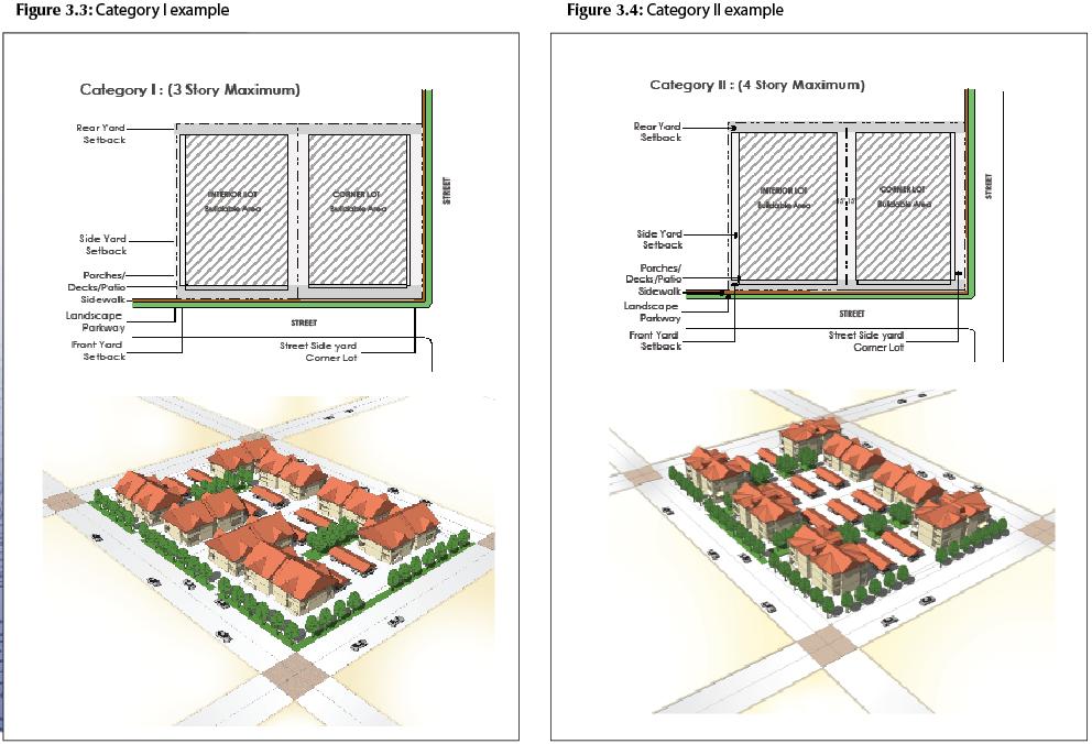
6 collector streets, arterial streets or highways may increase their building massing, heights, and densities as outlined in this document. The dimension of the site adjacent to a future planned street widening for collector, arterial, highway or a similar major street will be excluded from the calculation Multifamily Category Types These design guidelines establish three categories of multifamily design criteria consistent with the context type of adjacent existing communities. Category I Multifamily Projects Category I projects will be located in areas with mostly very low- and low-density residential uses, rural residential areas, and large single-family estate lots with adjacent agricultural lands (five units per acre or less). This category of multifamily projects would likely occur along or next to major transportation corridors where multifamily 6
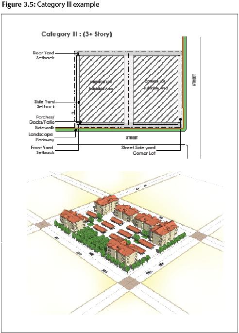
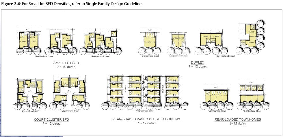
7 residential and commercial uses are typically found. Projects developed as Category I sites should locate buildings further from property lines, with an emphasis on landscaping to buffer buildings and surface parking lots. Buildings should be no more than two stories in height. Sidewalks, if present, should have landscaped parkways between the curb and sidewalk. Category II Multifamily Projects Category II projects will be located in areas with mostly low-density and medium-density residential uses (seven to 15 units per acre). Multifamily projects often occur along major transportation corridors where existing multifamily residential and commercial uses are found. Category II projects should be set back from surrounding properties so that their greater mass will not overwhelm adjacent properties. Landscaping should be provided along property lines to soften the transitions between the multifamily units and adjacent single-family development. Buildings may be as tall as four stories interior to the lot and closer to the streets, but should be designed to maintain privacy for any adjacent single-family properties. Wherever possible, sidewalks should provide a landscape buffer between the sidewalks and curb. Category III Multifamily Projects Category III multifamily projects will be located in areas mostly urban in character with surrounding high-density residential uses (more than 15 units per acre) as well as commercial, mixed use or industrial uses. Sidewalks are usually present, in some cases buildings are built to property lines. Category III projects may have four or more stories closer to the street. The most intensely developed Category III projects may provide structured or podium-style parking. Category III projects may also be mixed use projects, with commercial uses on the first floor, and residential units above. Mixed use projects shall comply with guidelines and standards outlined in the Chapter 6.0 Village Center / Mixed Use District Category I and II projects may be allowed to step up to the next higher multifamily category along major transit-oriented corridors, major arterial and collector roadways. These include projects in Corridor Plans, Transit-Oriented Districts, Special Planning Areas, and non-residential Neighborhood Preservation Areas (special overlay) subject to the approval of the Planning Commission through the Conditional Use Permit and Design Review process. The application of these Housing Category Types is found in individual sections below. 7
8 8
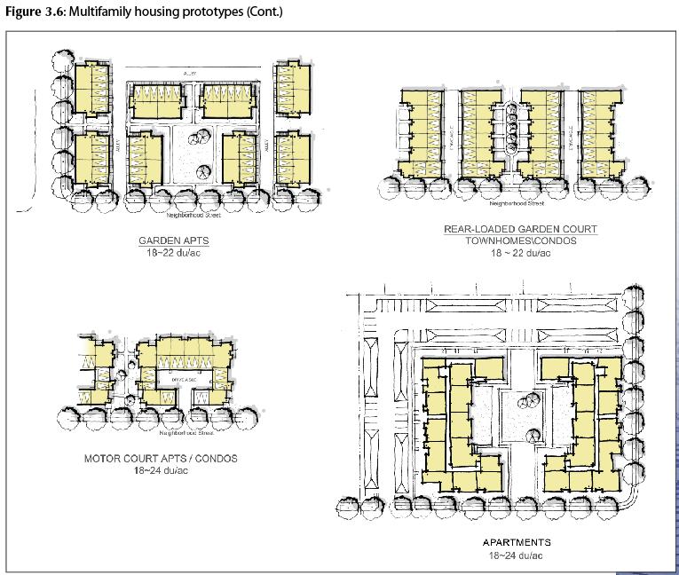
9 3.1.3 Multifamily Housing Types A range of housing types can be provided within multifamily districts. These building types may include: garden apartments, two- and three-story walk-up apartments; row houses or town-houses; small-lot single-family homes; four-, six-, and eight-unit apartment buildings; clustered buildings; podium apartments; mid-rise and high-rise towers; duets and duplex buildings; and pull apart town house designs (Refer Figure 3.3). All the described multi-family housing types shall adhere to the applicable standards of the Zoning Code unless alternatives can be justified by provisions of these. It is the intent of these to allow for maximum design flexibility to achieve a quality residential environment. The development standards are intended as a general guide, and creative and innovative designs are highly encouraged. These design standards provide the minimum requirements to maintain compatibility with surrounding neighborhoods, increase safety and security for the residents, and create a higher quality environment and a strong sense of place in Sacramento s communities. Creative and imaginative design solutions for multifamily designs are encouraged. These guidelines cannot address all specific conditions or possible solutions to site and building design. Architects and building designers are continually creating new and imaginative solutions to multifamily housing design that would also be applicable to multifamily housing zones. It is the intent of these design guidelines to allow for maximum design flexibility to achieve a quality residential environment. 9
10 10
11 Apartments Apartment buildings can be single multi-unit buildings or clusters of multi-unit buildings. They are often multi floor and can be designed for general or specific type occupants. Their occupants share communal open space and parking facilities. When clustered they commonly have a unified design and/or theme. Townhouses Townhouses (and row houses) can be attached single-family homes, a duplex, a triplex, or more units in a multifamily zone that is owned in fee simple, and may include the land on which the structure sits. Detached townhouses are a series of buildings having no common walls or foundations with the adjoining townhouse and minimal separation between buildings, while attached townhouses share common walls and foundations with the adjoining townhouse. Detached townhouses (or pull-apart townhouses) are often designed as small two or three-story homes with separations between buildings. In no case, however, would the number of units in the townhouse development exceed the density permitted by the multifamily category designation of the site. Small-lot Single-family Housing Small-lot single-family development bridges the gap between conventional single-family housing and larger multifamily housing, creating a continuum of housing opportunities. Small-lot single-family housing tends to be more affordable than conventional singlefamily developments, providing an opportunity for home ownership, particularly for first time homebuyers and older adults without children. Homeownership opportunities in neighborhoods benefit from residents strongly invested in the community. Small lot residential single-family homes may be constructed in any multifamily zoning designation subject to County requirements for achieving the minimum density as a percentage of the maximum density permitted in that zone. Small lot single-family developments shall follow all guidelines as outlined for multifamily developments in this chapter and as supplemented by those in Chapter 2.0 Single Family. 3.2 Site Design Neighborhood Compatibility Design Principle Multifamily developments should be compatible with surrounding neighborhoods while providing a quality living environment. Good site planning and project design should minimize impacts on existing and planned adjacent uses. Project design should address traffic, relationship or access to transit, parking, circulation and safety issues, control of light and glare, noise, odors, dust, and security. Site layout and design should create a clear definition and relationship between the public and private realm. Neighborhood compatibility can be achieved through control of semi-public and semi-private spaces, landscape, and building details to improve the safety and security of residents. 11
12 Rationale Appropriate multifamily design that fits the context and surrounding neighborhood helps maintain property values, increases the safety and security of all residents, promotes a sense of place and neighborly interaction, and improves the overall quality of life for the community. Building Orientation Harmonize with surrounding uses and improve the overall appearance and character of the neighborhood through building massing, scale, heights, and style. Long expanses of windowless, blank walls are to be avoided. All building facades are to be treated aesthetically with changes in materials, colors, artwork, use of pilasters, building lines, ornamentation, and/or other aesthetic treatments; and, should utilize durable quality materials. Orient buildings to adjacent public streets by providing entryways, windows, porches, stoops, balconies, and other active spaces along street frontages. Active spaces oriented to the street provides for visual access, surveillance, and control over public realm, increasing safety and security for the users. Locate surface parking lots to the sides and rear of the lot with building massing oriented to the street, to the greatest extent possible. Provide parking lots with adequate lighting and security as a safety feature. Arrange multifamily residential buildings to provide functional, public and private outdoors spaces for the use of residents. Centrally locate active common open spaces such that they are easily accessible to all residents. Design and landscape street setbacks to create an attractive and varied streetscape. Include landscaping elements such as shade-trees, shrubbery, and ground cover. Avoid large expanses of hard surfaces, paving, rock and bark cover. Design building orientation to access and use solar energy. Connectivity Provide connections between new projects and adjacent neighborhood streets and pedestrian and bicycle paths. Connecting streets should be designed with appropriate widths to discourage overloading traffic on existing streets. Provide for future connections to currently underdeveloped properties. Allow for future connections to currently underdeveloped properties. Gated communities are discouraged in locations where there is good opportunity for connectivity to adjoining neighborhoods. Gated communities may be appropriate for some projects. Disperse access to new development by providing more than one entrance and exit. 12
13 Create slower, pedestrian-oriented residential streets within the project site and its surrounding neighborhood through traffic calming measures such as traffic circles, chokers, and narrower streets, to the greatest extent possible. Design connectivity with adjacent developments via internal drives and biking or walking trails. Allow pedestrian movement to and along sidewalks to be clear and unobstructed. Use of separated sidewalks is encouraged. Design pedestrian paths and access to be clearly visible during the day and well lit after dark. Spatially define and activate streets and common open space areas with building entries and storefronts (if a mixed-use project). Define major connectivity routes with hierarchal landscaping treatment. Street Elevation Design the building elevation along public streets with respect to its surrounding context. The design should foster an appearance of a residential neighborhood, with articulation and scale, particularly at street level, reflecting the character, rhythm, height, and massing of nearby residential buildings. Provide entries that allow residents to see and be seen. Integrate entries with second floor elements such as balconies and decks. Building entries, including doors, porches, and stoops should be the predominant feature of street fronting buildings. Discourage long expanses of windowless, blank walls. Allow direct views to the street from active spaces within dwelling units through windows facing the street. Discourage garages and on-site parking dominating building facades along streets. Good Neighbor Design Projects should be mindful of adjacent developments through use of good neighbor design strategies such as massing and building orientation. Consider shade impacts on adjacent properties in site design. Consider the existing grade and topography of the site in building layout, height, scale, and massing to maintain compatibility with adjoining lower intensity residential uses. Taller buildings on hillsides should be stepped back or reduced in height when adjacent to lower intensity residential uses to maintain the privacy of rear yards, patios, and private outdoor spaces. Improve the visual quality of the streetscape with projects that complement, rather than replicate, the architectural style and character of the surrounding area. 13
14 Minimize the potential for the disruption of privacy of adjacent neighbors/buildings through building design that restricts views directly into adjoining buildings, private open spaces, yards, and patios. Corner Lots Create a strong relationship between corner lots and adjoining streets through elements such as wrap-around porches, bays, and entries. Create attractive building facades facing both streets through massing and design of corner lots. Create attractive building facades through well-articulated sides of buildings. Achieve articulation with windows, setbacks, entries, porches, and/or balconies. Provide windows with views onto outdoor spaces for additional security and visual interest Setbacks Design Principle Setbacks of multifamily residential structures should be compatible with the character and setback along the street and surrounding neighborhood. Multifamily developments constructed adjacent to single-family residences should reflect the larger setbacks of the neighborhood, whereas reduced setback may be appropriate in more urban areas. Rationale Building setbacks help establish the continuity and character of a neighborhood and help protect the privacy of neighbors. Appropriate setbacks provide a transition between public and private spaces, provide functional spaces for outdoor activities, allow for light, fresh air circulation within buildings, and provide spaces for landscaping, trees, ground cover, and shrubs. Provide building setbacks that reflect the surrounding context. Design site plans with variation in both the street patterns and the siting structures so the appearance of the streetscape does not become overly repetitive and monotonous. Avoid continuous rows of buildings with the same setback. Modulate and vary building setbacks to avoid monotonous streetscapes, create small outdoor places along the street frontage, and better define entries and front yards. Design the primary facade of buildings with varied setbacks to create an interesting and attractive street edge, while maintaining minimum average setbacks consistent surrounding properties and these Guidelines. Extend porches, stairs, and stoops into the front setback to articulate the building facade. 14

15 Design setbacks between buildings so that spaces are usable or are part of the overall pedestrian scheme. Based on the Housing Category Type, setbacks that differ from the Zoning Code standards may be used as outlined in Table 3.5, measured from the street right-of-ways, providing that they can be justified as being in accordance to overall provisions of these design guidelines. Setbacks shall allow enough room for utilities, if greater than those outlined. Front setbacks shall be measured from the front property line or future front property line if street dedication is required for future rights-of-way. The intent is to provide for lesser setbacks in more urban, commercial settings (Category III projects). These alternative setbacks do not apply when located adjacent to single-family residential homes. Setback from Existing Single-Family Residential Multifamily housing development design should complement adjacent single-family homes, and should reflect larger setbacks through variation of building heights and stepping back building heights from adjacent single-story structures. Rationale Existing single-family residents are often adversely impacted by adjoining multifamily projects due to increased noise, traffic, increased shading, light and glare, and unwanted visual intrusions into both indoor and outdoor private spaces and yards. Good design can resolve many compatibility problems between single-family homes and adjacent multifamily residents through the use of appropriate setbacks, screening, and control of scale and massing of multifamily buildings, particularly near the property line between single-family and multifamily properties. Proper side yard and rear yard setbacks are critical to creating compatibility of scale and building massing. 15
16 Generally, single-family homes allow for minimum five-foot side yards, and minimum 20-foot rear yards. Multifamily dwellings should provide additional setbacks, landscaped screening along property lines, and limit the building lengths along property lines to reduce potential impacts on adjacent sites. Street widths provide sufficient distances and setbacks from existing single-family residences across the street. Consider the scale, character and location of the multifamily project and the type and width of the street in locating building massing on the site (i.e., portions of buildings with two or more stories and long building facades). Design building heights of new multifamily projects to be compatible with adjoining building heights to minimize potential impacts on adjacent singlefamily residences. Step back multi-story structures to reduce the bulk and mass adjacent to single family homes. Orient windows on multi-story structures away from single-family homes to the extent possible. Required setbacks adjacent to existing single-family residences shall not apply to front yard setbacks of sites with single-family residences across a street. On-Site Building Separation Multifamily buildings should be separated by a sufficient distance to maintain and protect the privacy of units facing one another, reduce unwanted noise, and provide for light, ventilation, and air circulation to the buildings and windows opening into common open spaces. Rationale Multifamily residential design often involves the organization on one site of several buildings separated by open spaces, paseos, parking lots, drive isles, and yards interior to the project. Buildings too close to one another can impact the livability of residences due to reduced privacy, intrusions of noise, and/or reduced light, air, and ventilation to individual units. Good building design and thoughtful placement of buildings and landscaping can help to create an attractive and more livable environment for residents. This distance will maintain a sense of enclosure while providing sufficient separation for ventilation, light, air, and privacy of interior units. Buildings can be closer together at corners, or at ends of the buildings where windows, private outdoor spaces, and balconies are not directly facing one another. Small narrow interior yards (less than 5 in width) often become left over unsupervised, unusable nuisance spaces that collect trash, garbage, and are seldom maintained. In some cases, however, tighter spaces, if relatively short in distance, can create attractive pedestrian alleyways leading to larger common open spaces, courtyards, and pedestrian plazas or leading to parking areas. 16
17 Maintain separation between residential buildings sufficient to provide privacy between units and outdoor private open spaces and balconies. Orient windows, private balconies, patios, and courtyards between buildings to protect the privacy of users and reduce unwanted noise between units. Use fencing, landscape screening, and the orientation private outdoor spaces of units to protect the privacy of units facing one another in adjoining buildings. Eaves, balconies, porches, and other architectural elements can project into interior side yards and open spaces between buildings if the privacy of units is maintained. Staggering and offsetting of window, entries, balconies, and private patios can provide for greater privacy where buildings are closer together. Buildings can be located closer together where windows, entries, balconies, and private outdoor spaces are not facing one another. Staggering building facades along interior spaces creates additional variety and interest to the site and building design. Avoid small, narrow interior side yards with no functional purpose that can become nuisance areas without proper maintenance Open Space and Common Outdoor Amenities Design Principle Multifamily developments should provide easily accessible and functional open spaces and common outdoor amenities for residents. Open spaces may include all landscaped yards, planters, planted buffers and common recreation areas such as playgrounds, pools, picnic areas, tot lots, and community patio areas. Common open spaces should be provided as appropriate for the ages and number of residents living within the project. Rationale Well-designed and accessible common open spaces foster a sense of community within a multifamily project. Open spaces also encourage physical activities and are key to creating healthy communities. By making open spaces more accessible from adjacent livable spaces, a wide range of activities are generated within and around open spaces throughout the day. Visual surveillance of open spaces provides for safety and security of users. Open spaces and common amenities within multifamily projects offer the types of private and semi-private spaces associated with single-family residences. Provide pools, recreation facilities, tennis courts, spas, hot tubs, seating, water fountains, tot lots, and similar features as common open space amenities to serve different age groups, as appropriate. Landscaped stormwater quality design measures can be integrated and placed into open space areas to provide stormwater quality benefits and landscaping benefits. 17
18 Locate and organize common open spaces such as parks, as large meaningful areas, and not unusable fragments. Emphasize doors, entries, windows and private open spaces opening onto these common areas to the greatest extent possible. Design open spaces connected by a comprehensive, on-site pedestrian circulation system to maximize accessibility and use by residents from all buildings. Locate and landscape open spaces, recreation areas, plazas and courtyards to take advantage of solar orientation, provide protection from wind, and afford shade during hot summer months. Provide recreation areas for children, unless a multifamily project is identified as an adults only or senior project. Provide appropriate amenities to serve anticipated residents (such as on-site child care and play lots for projects with families and children, less parking and more walking paths for senior housing). Locate common open spaces such as tot lots, children s play areas, picnic facilities, pools, and similar amenities to allow maximum visibility from surrounding residences and streets. Locate common facilities such as laundry rooms, mailboxes, and community areas adjacent to common open spaces to maximize their visibility and activity. The Zoning Code requires that minimum of 30 percent of the total project site area be provided as landscaped open space including walkways, drive aisles, parking areas, etc. For all multifamily projects of 25 units or more, a portion of all common open space shall include outdoor amenities such as, but not limited to, picnic tables and outdoor seating, pools, common patios, tot lots and play equipment, tennis courts, barbecue areas, hot tub, or other similar active recreation spaces for the residents. All small-lot developments shall provide a common open space with amenities if there is no neighborhood park or other available open space with recreational amenities within walking distance of residential units. All on-site outdoor amenities shall be preserved and maintained for the life of the project, unless otherwise approved by the Planning Director. Public and common use areas shall be accessible to and usable by people with disabilities. For townhomes and small lot developments, private yard areas may be counted towards total open space Private Open Space Design Principle Multifamily developments should provide easily accessible private open space to all dwelling units. There should be an emphasis on dwelling units opening onto private open spaces. 18
19 Rationale Private open spaces provide for a pleasant and functional living environment for residents. Private open spaces act as transitional areas between public open spaces and the private and semi-private spaces of the dwelling unit. Private outdoor open spaces provide residents with an attractive outdoor place that can be used for outdoor eating, barbeques, small private gardens and flower beds, sunbathing, or simply enjoying the environment. Design usable open spaces such as porches, front yards, patios, decks, and balconies to qualify as private open spaces. Provide each dwelling unit with a private open space such as an at-grade patio, stoop, porch, or balcony for upper stories for the exclusive use of that unit. Provide private open spaces of a reasonable size to afford functional and comfortable outdoor living opportunities. Provide balconies and porches at a width deep enough to allow for a chair or small table to be used. Do not place amenities such as air conditioning and other mechanical equipment in private open spaces such that it may render the space unusable or fragmented. Locate private open spaces to take advantage of solar orientation, shade in the summer, and breezes to the greatest extent possible. Integrate decks and patios into the overall design of the building, such that it does not appear to be applied to the building facade. Personal storage spaces (storage closets) may be designed as extensions of private open spaces, decks, or porches, or placed within garages and carports. Encourage raised front porches or front stoops for ground floor units. The first floor level, if raised above the grade of the sidewalk directly in front of the front entrance, provides for greater privacy at the entry and improves surveillance of the public street. The Zoning Code requires a minimum of 40 sq. ft. per dwelling unit of private open space, such as balconies and patios. Ground floor private patio spaces may be counted as a subset of the overall 30 percent landscaped open space requirement Scale and Mass Design Principle The scale and mass of multifamily residential structures should be compatible with the adjacent neighborhood and vary based on character, scale, and edge conditions of surrounding existing developments. 19
20 Rationale Stepping building heights, breaking up the mass of the building and shifting building placement can help mitigate the impact of differing building scales and intensities. Step down buildings at upper levels in neighborhoods with relatively smaller scale, particularly single-story, buildings on adjacent lots. Allow a scale transition between larger-scale buildings and smaller-scale buildings on adjoining lots. Use varied roof forms, mass, shape, and materials to create variations in building facades. Encourage variation in the number and mix of unit sizes to the greatest extent possible. Create varying front setbacks, staggered roof planes, and variety in orientation for units clustered into one structure. Avoid a monotonous or monolithic institutional appearance in favor of an appearance of distinct and articulated smaller attached buildings. Design buildings with a street facade which is complementary in scale and massing to its surrounding. Provide a sense of pedestrian scale at the ground level for buildings facing public streets and spaces through appropriate use of building materials, and details such as posts, wainscoting, decorative tiles, shutters, and window boxes. Massing and Scale on Major Streets Building massing and scale should be intensified along major streets and at intersections to define the street edge. Rationale Many multifamily housing projects are often located near or adjacent to major collector and arterial streets. These streets are four to six lanes wide and most often provide sufficient capacity to handle traffic generated by multifamily housing developments. Greater building massing along wider streets helps visually define the street edge and create a sense of place and street enclosure. In combination with appropriate pedestrian improvements and design features, such massing can help create a more interesting, pleasant, and safe street environment. It is also important to note that the location of multifamily housing along major streets raises several issues, which can be addressed through good design, such as controlling street noise, air quality impacts, and the quality of the street environment for pedestrians. Help define the street edge through the location of building massing and heights. Increase building mass and height proportional to the street width, with higher massing on wider streets and decreased massing on narrower streets. Housing 20
21 Category III projects should have a greater massing along major streets with decreased setbacks and greater heights. Reinforce the pedestrian scale along the street edge through orientation of building entries, windows, stoops, front porches, and decks. Define the street corner and create a strong visual statement at intersections with taller buildings, design elements and massing on corners. Design building massing and height to be greater along the street edges and at corners of wider arterial and collector streets and stepped down in scale to be compatible with the scale and massing of lower intensity buildings on adjacent lots. On major collector and arterial streets with widths of 80 feet or more building heights may increase along the street front by an additional one story or 15 feet (whichever is greater) above the existing height limit, provided the setback standards adjacent to existing single-family residential lots are maintained. On major arterial and collector streets with widths of 80 feet or greater, front yard setbacks from the street, front property lines, or back of sidewalks should conform to the existing setback standard. Height Limits Relate building heights closest to property lines to the height and scale of adjacent buildings. Allow buildings to have greater height in more intensely built areas. Greater heights (no height limit) are allowed and encouraged for Housing Category III projects. Require site specific design reviews based on sightlines to determine whether taller building design fits within the context of its surrounding. Density Multifamily developments should be within the ranges per existing zoning, except that Multifamily developments in Category III locations have no upper limit on density over the base zoning with the issuance of a Special Development Permit. For such higher density projects, overall community compatibility should be closely evaluated. Density requirements should also comply with other requirements, particularly with infill lots in existing neighborhoods Circulation Design Principle The visual prominence of vehicles should be minimized by siting parking areas to the rear or side of the property rather than along street fronts, and by providing underground 21
22 or partially underground parking. Surface parking areas should be screened from views exterior to the site. Parking shall be designed to minimize potential pedestrian-vehicle conflicts and impervious surfaces. A larger number of smaller parking areas are preferred to a smaller number of large parking areas. Parking should be configured to reduce the distance between a resident s parking space and dwelling unit. The location and design of driveways should minimize the impact of automobile circulation on the pedestrian environment and adjacent properties. Paseos can supplement the role of streets and drives in the pedestrian circulation network. An accessible pedestrian paseo network may provide front door access to units and allow for higher overall densities. Paseos should be designed as pedestrian streets and allow for clear and comfortable access to common site amenities, the public street, and visitor parking. Rationale Planning for safer and efficient movement of vehicles and pedestrians can result in an aesthetically appealing site, increased pedestrian safety, reduced amount of impervious surface, and increased open space on site. Well-designed vehicle and pedestrian circulation within the development helps clarify the relationship between private and public spaces and areas intended primarily for vehicles versus pedestrians. Smaller driveways, curb cuts and parking areas can reduce barriers to pedestrian movement, improve the aesthetics of the site, and reduce development costs. Organize street patterns in multifamily site designs to be clear and understandable, supporting wayfinding (methods by which individuals orient themselves and navigate through an area) by users. Organize the circulation system of larger multifamily projects (80 units or more) as a simple hierarchy of streets, driveways, parking areas and alleys with at least two points of access to public streets where feasible. Encourage well connected pedestrian routes within the project site and to the surrounding neighborhood, with an emphasis on relationships to open space networks. Provide reasonable access for persons with disabilities. Entrances, Exits and Connections Create internal circulation and connections between the project and the street to address the needs of pedestrians, bicyclists, and vehicles. If located along a transit route, provide convenient access to transit stops from multifamily projects. Design new projects that provide connections to adjacent development and allow for connections to future developments. Minimize total impervious surface resulting from pavement, sidewalks, and parking through use of landscaping and landscaped open spaces. 22
23 Locate vehicular entrances and exits to provide for safe sightlines and distances from street corners and intersections. Provide adequate and well landscaped pedestrian ingress and egress from the development to public rights-of-way, bus stops, and public transit to reduce long walking distances. Connections through public and common use areas must be accessible to people with disabilities. Public Streets Allow new projects to provide for as many on-street parking spaces as safely as possible. Design a planter strip between the curb and sidewalk as an additional buffer between the streets and pedestrians on the sidewalk, thereby increasing safety and allowing for street tree planting and as a stormwater quality benefit to help slow and reduce the amount of runoff to the street gutters. Multifamily developments in Category II and III should provide a minimum 5- foot wide planter strip between the pavement edge and sidewalk. In infill areas, sidewalks and planters may match the existing pedestrian environment, with the intent to separate sidewalks from the street wherever possible. Internal Streets Design internal streets to connect to local landmarks or amenity features such as parks or community buildings, tot lots, or stands of large trees, if present adjacent to or near the project. Design internal streets to include landscaping and provide spaces and pedestrian amenities for social interaction such as small gathering areas, gang mail boxes, benches and seating, water features, and shaded areas. Provide traffic calming measures such as roundabouts, narrower roadways, onstreet parking, chokers, and speed bumps along internal streets. Design internal streets with sidewalks to promote pedestrian activity within the development. On larger projects, provide loop circulation on internal streets to the greatest extent possible and minimize segregation of common open spaces. Develop projects that face internal streets to enhance the general livability, visual quality, and safety of the street. Design internal streets, parking lots, and driveways as parking courts that provide for additional outdoor hard surface play spaces by controlling traffic speed and movements. Such joint use of parking areas provides opportunities for additional social interaction between residents. 23
24 Consider designing narrower street sections where fire access is not required to reduce the amount of impervious area and enhance the appearance of driveways. For internal streets, include a minimum five foot wide landscaped buffer along roadways adjacent to property lines. Driveways and Internal Circulation Minimize the number and width of driveways and curb cuts. Design shared driveways to the greatest extent possible. Create textures, patterns, and colors in the design of paved parking areas or entries to create visual interest and to distinguish them from other paved areas. Do not design large monolithic areas of single color untextured paving. Use accent paving such as textured paving and paving blocks in driveways. Design driveways to be well lighted and distinct from building lighting, common housing lighting, or appropriate scaled street lighting. When designing streets with cul-de-sacs, live-end cul-de-sacs are preferred. Live-end cul-de-sacs provide for pedestrian access at the ends to adjoining streets, open spaces, parks, and trail systems while still permitting the cul-de-sac to be used as a common outdoor space. For driveway access with ten or fewer units, consider a T-shaped turnaround. A dimension of 20 feet by 80 feet will accommodate most vehicles. Consider using Hollywood driveways to reduce the amount of impervious area and enhance the appearance of driveways (refer to the County s stormwater quality design standards). Design traffic islands with attractive, low-maintenance shrubs or perennials, appropriate for the soil and moisture conditions. Dead end driveways should be less than 150 feet long, and have appropriate turnarounds as needed. Minimum widths for internal streets or driveways, per Fire Department Standards: o Uncurbed driveway with no parallel parking when fire lane is not necessary 16 o Curbed internal street with no parallel parking 20 o Curbed internal street with parallel parking on one side 28 o Curbed internal street with parallel parking on both sides - 36 Street design and width should be confirmed with the Fire Department. Paseos/Pedestrian Paths 24
25 Paseos provide common outdoor spaces and allow for pedestrian access through the development. Front door access to units may be provided via paseos, with these spaces acting as both public and semi-private spaces. These spaces could be further enhanced to be user-friendly through the use of appropriate pedestrian amenities such as seating, lighting, fountains, and landscaping. Paseos can also function as outdoor gathering places for residents, and provide additional recreational amenities such as game tables, small children s play area, picnic tables, outdoor gazebo, community garden, and other smaller community amenities. Paseos that terminate on a public street should be attractively landscaped and identified with an entry gateway. Locate paseos where vehicular connections are infeasible due to project or site constraints. Visually identify paseos by special paving and pedestrian-scale lighting. On pedestrian pathways, include amenities such as trellises, trees, seating, lighting and landscaping that visually extend the open spaces for safe pedestrian use. Provide lighting for safety and visual access. Front buildings onto paseos with windows, entries, and balconies to increase the visual surveillance of the area for safety and security. Limit the length of the paseo walkway and provide perpendicular connections from the paseo between buildings to parking areas, public streets, and open spaces. Design paseos to provide sunlight during the day, whenever feasible. Allow a paseo to be named as a special place with buildings lining the paseos taking their addresses from the paseo. Direct roof runoff to bioretention planters and landscaping strips in the paseos for treatment, whenever possible. Parking Parking is critical to the success of a multifamily residential project. Parking needs to be convenient, accessible, safe, screened from street views, and well landscaped to reduce summer heat gain, and controlled stormwater runoff. With the exception of higher intensity urban areas, mixed use villages, and town centers where apartment buildings are more common, most new apartment designs are two- to three-story walk-up structures. These are often referred to as garden-style apartments with a mix of unit types serving singles, couples, and young families. Minimal parking requirements by Category are indicated in Table Any variations are subject to justification by the project being in accordance to overall provisions of these. Two basic strategies can be applied to the site layout of multifamily apartments: 25
26 1. Internalized parking lots with good configuration layouts and buildings that ring the site and allow for casual surveillance. These layouts should be encouraged. 2. Externalized parking with buildings that cluster around a central common open space with parking oriented to the exterior. In most developments, both approaches are utilized to conform to site conditions. External parking increases building setbacks from adjacent properties, and provides more direct access to on-site community recreational facilities. However, external parking lots become more exposed to the surrounding community. The minimum number of parking spaces is regulated by the Zoning Code. Reductions to the minimum standards can be made for Category III projects. The Zoning Code further requires that a portion of the parking be covered. Locate parking and vehicle access away from street corners. Screen parking areas visible from the street right-of-way with landscaping, berms, or decorative visual barriers. Discourage use of fences or walls as the preferred method of screening parking from the street. Buffer parking areas from adjacent residential properties. Provide landscaping adjacent to and within parking areas to screen vehicles from view. Multiple smaller parking lots are preferred over single, large lots to minimize the expansive appearance of parking areas. However, the parking lot design should not negatively impact the design of the project. If large parking areas are needed, design a clearly defined pedestrian path inside the parking area that provides safe and easy access to and from buildings and sidewalks. Plant trees and shrubs to soften the overall impact of parking areas and to provide shade and noise reduction. Locate secure bicycle parking close to, and with direct access to, residential buildings and entries. Set back parking adjacent to dwelling units to provide a buffer between the parking area and living areas and to reduce the potential impacts of noise and light on adjacent residences. Provide appropriate buffers through a combination of landscaping, walkways, private outdoor patios and/or low walls. Do not allow parking and paving to directly touch against residential buildings. Incorporate stormwater quality measures into the parking areas to treat the storm runoff and enhance the parking areas by providing shade and reducing the amount of paving. Vehicle wash areas shall be designed to the latest stormwater quality design standards. Consider subterranean parking for Category III projects located along three and four lane roads, with paseos or similar public spaces as entrances to the complex, and allowing better utilization of site area. 26
B L A C K D I A M O N D D E S I G N G U I D E L I N E S for Multi-family Development
 B L A C K D I A M O N D D E S I G N G U I D E L I N E S for Multi-family Development Adopted June 18, 2009 This section of the Design and focuses on site planning and design guidance for new multi-family
II. SINGLE FAMILY RESIDENTIAL
 II. SINGLE FAMILY RESIDENTIAL Castle Rock is made up of numerous individually built houses and subdivision tracts that have been developed during the past century. Some of the tracts are diverse in architectural
MULTIFAMILY RESIDENTIAL DESIGN PRINCIPLES Site Plan and Design Review Principles Checklist
 MULTIFAMILY RESIDENTIAL DESIGN PRINCIPLES Site Plan and Design Review Principles Checklist Applicant s Name: Project Address: Phone: Email: Applicant shall fill out the design guidelines checklist for
WEST LOOP DESIGN GUIDELINES CHECKLIST
 WEST LOOP DESIGN GUIDELINES CHECKLIST Section 1.0 General Strategies 1.1 DESIGN EXCELLENCE: ENCOURAGE HIGH QUALITY AND INNOVATIVE DESIGN OF NEW BUILDINGS WITHIN THE WEST LOOP WITHOUT BEING PRESCRIPTIVE
Buildings may be set back to create small plazas provided that these setbacks do not substantially disrupt the street wall s continuity.
 6-22 Community Design Street Walls and Street-front Setbacks The siting of buildings will play a critical role in establishing the character and sense of place for the District. Siting buildings at the
FLORIN ROAD CORRIDOR Site Plan and Design Review Guidelines Checklist
 FLORIN ROAD CORRIDOR Site Plan and Design Review Guidelines Checklist Applicant s Name: Project Address: Phone: Email: Applicant shall fill out the design guidelines checklist for all guidelines applicable
Policies and Code Intent Sections Related to Town Center
 Policies and Code Intent Sections Related to Town Center The Town Center Vision is scattered throughout the Comprehensive Plan, development code and the 1994 Town Center Plan. What follows are sections
VILLAGE OF SKOKIE Design Guidelines for Mixed-Use Districts NX Neighborhood Mixed-Use TX Transit Mixed-Use CX Core Mixed-Use
 VILLAGE OF SKOKIE Design Guidelines for Mixed-Use Districts NX Neighborhood Mixed-Use TX Transit Mixed-Use CX Core Mixed-Use TABLE OF CONTENTS CHAPTER 1 SITE DESIGN Purpose 1 CHAPTER 2 SITE DESIGN Streetscape
PUBLIC RIGHT-OF-WAY IN THIS CHAPTER PUBLIC REALM
 PUBLIC RIGHT-OF-WAY This section provides design guidelines for improvements in the public right-of-way. The public right-of-way refers to streets, sidewalks, non-vehicular thoroughfares, parks and greenways
Proposed for Vic West Neighbourhood Plan. Design Guidelines for Intensive Residential Development - Townhouse and Attached Dwelling
 Proposed for Vic West Neighbourhood Plan Design Guidelines for Intensive Residential Development - Townhouse and Attached Dwelling Design Guidelines for Intensive Residential Development - Townhouse and
for Master Planned Development Framework Design Standards & Guidelines
 B L A C K D I A M O N D DE S I G N G U I D E L I N E S for Master Planned Development Framework Design Standards & Adopted June 18, 2009 Introduction and Purpose The Master Planned Development (MPD) Framework
Infill Residential Design Guidelines
 Infill Residential Design Guidelines Adopted March 23, 2004 Amended September 10, 2013 City of Orange Community Development Department Planning Division Phone: (714) 744-7220 Fax: (714) 744-7222 www.cityoforange.org
4.0 Design Guidelines For The Village Centre. South fields Community Architectural Design Guidelines Town of Caledon
 4.0 Design Guidelines For The Village Centre 4.0 Design Guidelines for the Village Centre The Village Centre is the focal point of the entire South Fields Community and is designed as a traditional commercial
Highland Village Green Design Guidelines
 Highland Village Green Design Guidelines Publishing Information Title Highland Village Green Design Guidelins Author The City of Calgary Status DRAFT - Proposed document subject to changes Additional Copies
4.9 Mendocino Avenue Corridor Plan Design Guidelines
 4.9 Mendocino Avenue Corridor Plan Design Guidelines The Mendocino Avenue Corridor Plan addresses the area between College Avenue and Steele Lane. Mendocino Avenue is a busy arterial that runs parallel
Residential Design Guidelines
 Residential Design Guidelines Single-Family Residential Design Guidelines Introduction These guidelines seek to provide property owners, designers and developers with a clear understanding of the City
Community Design Plan
 Gardena General Plan 2006 Authority While the is not a required element of a General Plan, it is included because improving the community appearance and image is paramount to the overall quality of life
Design Guidelines for Multi-Family Residential Development
 Design Guidelines for Multi-Family Residential Development Development Services 972-466-3225 cityofcarrollton.com September 2012 Table of Contents Purpose... 1 Design Objectives... 2 Building Design Guidelines...
4. INDUSTRIAL 53 CASTLE ROCK DESIGN
 4. INDUSTRIAL 53 CASTLE ROCK DESIGN CASTLE ROCK DESIGN 54 4. INDUSTRIAL Overview Well-designed and attractive industrial centers are the product of blending economic realities with both functional and
East Bayshore Road Neighbourhood
 East Bayshore Road Neighbourhood Northridge Property Management Urban Design Brief 3195 East Bayshore Road City of Owen Sound January 2016 East Bayshore Road Neighbourhood Northridge Property Management
SECTION TWO: Overall Design Guidelines
 SECTION TWO: Overall Design Guidelines This section provides overall design principles and guidelines for the Gardnerville Mixed-use Overlay. They provide criteria for mixed-use places consisting of residential,
Urban Design Guidelines Townhouse and Apartment Built Form
 Urban Design Guidelines Townhouse and Apartment Built Form Town of Wasaga Beach Table of Contents 1. Introduction 1.1. Purpose 1.2. Urban Design Principles 1.3. Application of Guidelines 2. Site Design,
INSTITUTIONAL USE DESIGN COMPATIBILITY TECHNIQUES
 INSTITUTIONAL USE DESIGN COMPATIBILITY TECHNIQUES INTRODUCTION Community institutions are an important part of the character and vitality of neighborhoods in Forsyth County. Institutional uses include
Walnut Creek Transit Village Design Guidelines. Part Three III - 25
 C. General Design Criteria Part Three DRAFT 0/6/ III - 5 Frontage Types Frontage is a semi-public transition zone at the ground level where public and private realms meet. An understanding of various frontage
DRAFT Northeast Quadrant of Kipling Avenue and Highway 7 DRAFT AUGUST 29, Goals Land Use. The goals of this Plan are to:
 AUGUST 29, 2017 12.15 Northeast Quadrant of Kipling Avenue and Highway 7 12.15.1 Goals 12.15.2 Land Use The goals of this Plan are to: 12.15.2.1 General Provisions: a) Ensure the development of a compact
ARTICLE 8 DESIGN STANDARDS
 ARTICLE 8 DESIGN STANDARDS 8.000 Overview. The purpose of this Article is to establish additional standards for certain uses. These standards are intended to reduce adverse effects on surrounding property
SMALL LOT DESIGN STANDARDS. An Illustrated Working Draft for Test Implementation
 SMALL LOT DESIGN STANDARDS An Illustrated Working Draft for Test Implementation SMALL LOT DESIGN STANDARDS ILLUSTRATED WORKING FOR TEST IMPLEMENTATION OVERVIEW SMALL LOT CODE AMENDMENT & POLICY UPDATE
Design Guidelines for Residential Subdivisions
 Design Guidelines for Residential Subdivisions Development Services 972-466-3225 cityofcarrollton.com This page intentionally left blank. Table of Contents Purpose... 1 Design Objectives... 1 Design Guidelines
DRAFT. 10% Common Open Space
 % OF CHARLOTTE IS CATEGORIZED AS A. LAND USES : Placeholder map displaying location of Place Type GOALS: Accommodate XX% of future growth. Provide a concentration of primarily commercial and civic activity
City of Bellingham. Multifamily Residential Design Handbook
 City of Bellingham Multifamily Residential Design Handbook ADOPTED BY RESOLUTION 2001-23 ON JULY 16, 2001 TABLE OF CONTENTS INTRODUCTION Purpose... 2 Applicability... 2 How to Use the Handbook... 2 Review
Duplex Design Guidelines
 Duplex Design Guidelines Adopted by Council May 29, 2006 Prepared By: Table of Contents 1.0 Application and Intent 1 2.0 Areas of Application 2 3.0 Design Principles 3 4.0 Design Guidelines 4 4.1 Site
Multi family Residential Development Permit Area
 City of Kamloops KAMPLAN Multi family Residential Development Permit Area PURPOSE The purpose of this Development Permit Area (DPA) is to establish objectives and provide guidelines for the form and character
13. New Construction. Context & Character
 13. New Construction Context & Character While historic districts convey a sense of time and place which is retained through the preservation of historic buildings and relationships, these areas continue
DRAFT DESIGN GUIDELINES
 IHZ Booklet #7 May 6, 2010 DRAFT DESIGN GUIDELINES CANTERBURY 7 Overview During the recent planning process for the Plan of Conservation and Development community character was identified as an important
SUBCHAPTER 4-B GUIDELINES FOR THE B-3 COMMERCIAL CHARACTER AREA
 1 SUBCHAPTER 4-B GUIDELINES FOR THE B-3 COMMERCIAL CHARACTER AREA Downtown Bozeman should be the location of buildings of greatest height and intensity in the community. The following guidelines apply
Design Guidelines Checklist
 Design Guidelines Checklist A quick reference to the City of Vista Design Guidelines City of Vista Community Development Department Planning Division 600 Eucalyptus Avenue Vista, CA 92084 760.639.6100
City of Vaughan Urban Design Guidelines for Infill Development in Established Low-Rise Residential Neighbourhoods
 City of Vaughan Urban Design Guidelines for Infill Development in Established Low-Rise Residential Neighbourhoods DRAFT - September 2016 Contents 1. Introduction 1 2. Policy Context 3 3. Characteristics
Clairtrell Area Context Plan
 Clairtrell Area Context Plan March 2005 Urban Development Services City Planning Contents 1. Introduction... 4 2. Development Structure... 6 2.1 Streets... 7 2.1.1 Sheppard Avenue and Bayview Avenue...
INTERIM MULTIFAMILY DESIGN GUIDELINES (INCLUDES ATTACHED AND DETACHED RESIDENTIAL PROJECTS) COUNTY OF SACRAMENTO
 COUNTY OF SACRAMENTO") INTERIM MULTIFAMILY DESIGN GUIDELINES (INCLUDES ATTACHED AND DETACHED RESIDENTIAL PROJECTS) COUNTY OF SACRAMENTO F I N A L D R A F T ADOPTED MAY 28, 2008 FINAL DRAFT Adopted May 28,2008 Prepared by: Assisted
INTERIM MULTIFAMILY DESIGN GUIDELINES (INCLUDES ATTACHED AND DETACHED RESIDENTIAL PROJECTS) COUNTY OF SACRAMENTO F I N A L D R A F T ADOPTED MAY 28, 2008 FINAL DRAFT Adopted May 28,2008 Prepared by: Assisted
Housing and Coach House Guidelines - Ladner
 Housing and Coach House Guidelines - Ladner Policy D.8: Encourage Compatible Housing Design Encourage housing design that is sensitive to existing single family housing neighbourhoods by requiring a design
Landscaping Standards
 CHAPTER 29 ARTICLE 403 29.403 Landscaping Standards Purpose: The purpose of this section is to protect and promote the public health, safety and general welfare by requiring landscaping in relation to
URBAN DESIGN BRIEF URBAN DESIGN BRIEF 721 FRANKLIN BLVD, CAMBRIDGE August 2018
 URBAN DESIGN BRIEF URBAN DESIGN BRIEF 721 FRANKLIN BLVD, CAMBRIDGE August 2018 DESIGN BRIEF CONTENTS PART A 1.0 INTRODUCTION 2.0 DESCRIPTION & ANALYSIS OF SITE CONTEXT 3.0 DESIGN CONSTRAINTS AND OPPORTUNITIES
Wide asphalt driveway abutting school property. garage built with incompatible materials, too close to park. incompatible fencing materials
 Wide asphalt driveway abutting school property incompatible fencing materials garage built with incompatible materials, too close to park Lack of plantings as a buffer between private property and open
5.1 Site Plan Guidelines
 5. Community Core Guidelines Development of the Community Core will take place by plan of subdivision and site plan approval. It will occur in a phased manner that will reflect the timing of residential
GUIDELINES REPLACEMENT HOUSING GUIDELINES LOCATION INTRODUCTION URBAN DESIGN GUIDELINES
 Replacement housing in the former City of North York will be consistent with the following urban design guidelines. They provide a framework for residential re-development in the former City of North York
Chapter PEDESTRIAN COMMERCIAL (PC) ZONING DISTRICT
 ZONING DISTRICT") Chapter 11-17 PEDESTRIAN COMMERCIAL (PC) ZONING DISTRICT Sections: 11-17-01 GENERAL PURPOSE 11-17-02 PERMITTED BUILDING TYPES 11-17-03 USES PERMITTED WITH DESIGN REVIEW 11-17-04 USES PERMITTED BY CONDITIONAL
Chapter 11-17 PEDESTRIAN COMMERCIAL (PC) ZONING DISTRICT Sections: 11-17-01 GENERAL PURPOSE 11-17-02 PERMITTED BUILDING TYPES 11-17-03 USES PERMITTED WITH DESIGN REVIEW 11-17-04 USES PERMITTED BY CONDITIONAL
(DC1) Direct Development Control Provision DC1 Area 4
 Direct Development Control Provision DC1 Area 4") . General Purpose (DC) Direct Development Control Provision DC Area 4 The purpose of this Provision is to provide for an area of commercial office employment and residential development in support of the
. General Purpose (DC) Direct Development Control Provision DC Area 4 The purpose of this Provision is to provide for an area of commercial office employment and residential development in support of the
Standards (R-3) Figure B-11: R-3 Residential Standards Exhibit
 Figure B-11: R-3 Residential Standards Exhibit") Avila Ranch Avila Ranch Specific Plan Development Standards High Medium Density - High Residential Density Residential Lot and Building Lot and Standards Building (R-3) Standards (R-3) EXAMPLES These sketches
Avila Ranch Avila Ranch Specific Plan Development Standards High Medium Density - High Residential Density Residential Lot and Building Lot and Standards Building (R-3) Standards (R-3) EXAMPLES These sketches
EXISTING COMPREHENSIVE PLAN
 EXISTING COMPREHENSIVE PLAN Town Center Land Use Element: V. LAND USE POLICIES Town Center Mercer Island's business district vision as described in "Your Mercer Island Citizen-Designed Downtown" was an
URBAN DESIGN BRIEF. 2136&2148 Trafalgar Road. Town of Oakville
 URBAN DESIGN BRIEF 2136&2148 Trafalgar Road Town of Oakville Prepared By: METROPOLITAN CONSULTING INC For 2500674 Ontario Inc November 2016 TABLE OF CONTENTS Page No. 1.0 Introduction/Description of Subject
Chapter 11. Industrial Design Guidelines 11.1 INTRODUCTION AND PURPOSE 11.3 SITE PLANNING GUIDELINES 11.2 GENERAL DESIGN OBJECTIVES
 Chapter 11 Industrial Design Guidelines 11.1 INTRODUCTION AND PURPOSE The following industrial/design guidelines seek to assure high quality development in Santa Ana s industrial districts by: The design
FREEWAY/TOURIST DISTRICT
 FREEWAY/TOURIST DISTRICT DESIGN STANDARDS FOR THE CITY OF MOUNTLAKE TERRACE March, 2014 MOUNTLAKE TERRACE FREEWAY/TOURIST DESIGN STANDARDS March, 2014 1 TABLE OF CONTENTS Introduction...1 Design Site Design
Corridor Identity. Section 9. Introduction. Corridor Guiding Principles
 Corridor Identity An attractive and healthy community is a critical element of a quality place, and the design of quality places is a balance between environmental, economic, and social considerations.
CHAPTER FIVE COMMUNITY DESIGN
 CHAPTER FIVE COMMUNITY DESIGN CHAPTER FIVE - COMMUNITY DESIGN Assumptions Frazier Park and Lebec have historically developed according to different patterns of spatial form. While both communities are
CONTENTS 8.0 LAND USE 8.1 GENERAL LAND USE 8.2 RESIDENTIAL 8.3 MIXED USE 8.4 COMMERCIAL 8.5 EMPLOYMENT LANDS
 8-2 Land Use 8.0 LAND USE CONTENTS 8.1 GENERAL LAND USE 8.1.1 Uses provided for in all Land Use Designations 8.1.2 Uses prohibited in Hazardous Lands, Hazardous Sites and Special Policy Areas 8.1.3 Uses
B. Blocks, Buildings and Street Networks
 B. Blocks, Buildings and Street Networks Figure IV.4 A rational block pattern with connected streets Introduction The single most important element in the physical and functional integration of mixed use
CENTERS AND CORRIDORS
 INITIAL DESIGN STANDARDS AND GUIDELINES for CENTERS AND CORRIDORS City of Spokane Planning Services Third Floor, City Hall 808 W. Spokane Falls Blvd. Spokane, WA 99201-3329 (509) 625-6300 www.spokaneplanning.org
Site Planning. 1.0 Site Context. 2.0 Pedestrian Circulation Systems. Pag e 2-23
 The following photographs from throughout the country illustrate key urban design principles. Photographs are provided to illustrate the overall urban design concepts described in Chapter 1 of the Downtown
This chapter contains the design standards and guidelines for development and improvement of office and industrial buildings and
 CHAPTER 4: INDUSTRIAL AND OFFICE This chapter contains the design standards and guidelines for development and improvement of office and industrial buildings and projects. Applicants should discuss specific
lot flankage Y street 16m 6m landscape strip for large site 3m landscape strip for small medium site
 Commercial General Commercial Objectives Create developments compatible with adjacent land uses in scale, function and character Define a consistent and attractive street edge with quality landscaping,
PROPOSED WATERFRONT DISTRICT DESIGN STANDARDS
 PROPOSED WATERFRONT DISTRICT DESIGN STANDARDS 20.25 DESIGN REVIEW. 20.25.080 WATERFRONT DISTRICT A. Purpose. This section is intended to implement The Waterfront District Subarea Plan by: 1. Creating a
Resolution : Exhibit A. Downtown District Design Guidelines March 2003
 Resolution 03-011: Exhibit A Downtown District Design Guidelines March 2003 DOWNTOWN DISTRICT DESIGN GUIDELINES CITY OF SOUTHLAKE, TEXAS Adopted March 2003 1 DOWNTOWN DISTRICT DESIGN GUIDELINES Adopted
Neighborhood Districts
 NEIGHBORHOOD DISTRICTS SEVEN MAIN DISTRICTS Neighborhood Districts While the Development Plan provides a broad-scale overview of the neighborhood, this section focuses on uses and relationships at the
MIXED-USE ZONING DISTRICT DESIGN GUIDELINES
 MIXED-USE ZONING DISTRICT DESIGN GUIDELINES In addition to the development regulations contained in the Mixed-Use Zoning District, design guidelines are presented here to provide an added level of definition
WINDSOR GLEN DESIGN GUIDELINES
 WINDSOR GLEN DESIGN GUIDELINES Adopted by Council, 2006 WINDSOR GLEN REDEVELOPMENT DESIGN GUIDELINES August 2006 1.0 Master Plan Organization For this area of the Coquitlam Town Centre, a mix of high,
CHAPTER 13 DESIGN GUIDELINES
 CHAPTER 13 DESIGN GUIDELINES Section 1300.00 Section 1300.01 Design Guidelines Purpose The purposes of this section are to: A. The purpose of this Section is to establish procedures and standards to serve
ATTACHMENT A. SILVERDALE DESIGN STANDARDS Amendments to the Waaga Way Town Center Chapter
 ATTACHMENT A SILVERDALE DESIGN STANDARDS Amendments to the Waaga Way Town Center Chapter Chapter 10. Waaga Way Town Center 10.1 Physical Identity Elements & Opportunities The Waaga Way Town Center includes
Planned Residential Neighborhoods Land Use Goals
 Planned Residential Neighborhoods Land Use Goals Issue: Guidelines that provide for diverse high quality residential areas that include a variety of housing styles and layouts are needed. Goal 1: Create
WATERFRONT DISTRICT DESIGN STANDARDS
 WATERFRONT DISTRICT DESIGN STANDARDS 20.25.080 WATERFRONT DISTRICT A. Purpose. This section is intended to implement The Waterfront District Subarea Plan by: 1. Creating a safe, vibrant mixed-use urban
Commercial Development Permit Area
 City of Kamloops KAMPLAN Commercial Development Permit Area PURPOSE The purpose of this Development Permit Area (DPA) is to establish objectives and provide guidelines for the form and character of commercial
Cha p t e r 2: Ge n e r a l De s i g n Gu i d e l i n e s
 Downtown Ann Arbor Design Guidelines Cha p t e r 2: Ge n e r a l De s i g n Gu i d e l i n e s This chapter presents general design guidelines for new site plan or PUD projects in downtown Ann Arbor. The
New-Cast Mixed-use Development Proposal King Street West, Newcastle, Ontario
 URBAN DESIGN BRIEF New-Cast Mixed-use Development Proposal King Street West, Newcastle, Ontario TABLE OF CONTENTS: 1.0 Executive Summary 2.0 Creating Vibrant and Sustainable Urban Places: Excerpts from
4.1.3 LAND USE CATEGORIES
 4.1.3 LAND USE CATEGORIES a. City Center District The City Center District incorporates the existing character and mix of uses in downtown Belmont to encourage redevelopment and new development in keeping
SECTION V: DESIGN GUIDELINE EXAMPLES
 SECTION V: DESIGN GUIDELINE EXAMPLES Introduction The Syracuse Town Center is envisioned as an area that creates a sense of place, a community downtown. As such, the Town Center Committee recommended the
Future Five. Design/ Development Guidelines. January 2008 Amended June 08 per City Council motion
 Future Five Design/ Development Guidelines January 2008 Amended June 08 per City Council motion 5-Points Design Guidelines Table of Contents I. Introduction 3 II. Area boundaries 4 III. Review Process
Cit of Kitchener Ur 6 an Design Manual PARTA. Desi n for _--::
 Cit of Kitchener Ur 6 an Design Manual Date PARTA Year ) Desi n for k Nodes Corridors _--:: Section Page 01 of 12 2 INTRODUCTION Purpose & Application Nodes and Corridors have been identified as key intensification
Design Guidelines. Roosevelt. Mike Podowski DPD Design Guidelines Ordinance ATT 13 August 13, 2012 Version #1
 Roosevelt Design Guidelines The Roosevelt Neighborhood Design Guidelines apply within the Neighborhood Boundary. Map 1 2 Map 2 3 Map 3 4 CS1 Natural Systems and Site Features Citywide Guideline: Use natural
CENTRAL CITY NEIGHBORHOOD Site Plan and Design Review Guidelines Checklist
 Applicant s Name: Project Address: NEIGHBORHOOD Phone: Email: Applicant shall fill out the design guidelines checklist for all guidelines applicable to the project. Check the box if meets guideline. Indicate
DESIGN GUIDELINES FOR: INTENSIVE RESIDENTIAL DEVELOPMENT TOWNHOUSE AND ROWHOUSE
 DESIGN GUIDELINES FOR: INTENSIVE RESIDENTIAL DEVELOPMENT TOWNHOUSE AND ROWHOUSE 1. Introduction Townhouse and Rowhouse Building Typologies Within these guidelines, the term rowhouse means a single row
FRUITVALE TRANSIT VILLAGE (Phase 2) Residential Project
 Residential Project") FRUITVALE TRANSIT VILLAGE (Phase 2) Residential Project DEVELOPER: SIGNATURE PROPERTIES ARCHITECT: HKIT ARCHITECTS April 23, 2010 TABLE OF CONTENTS 3 Vision 4 Description of Site 5 Guiding Concepts 6
FRUITVALE TRANSIT VILLAGE (Phase 2) Residential Project DEVELOPER: SIGNATURE PROPERTIES ARCHITECT: HKIT ARCHITECTS April 23, 2010 TABLE OF CONTENTS 3 Vision 4 Description of Site 5 Guiding Concepts 6
D. Landscape Design. 1. Coverage Intent: To provide adequate landscaping materials that enhance the appearance of development projects.
 D. Landscape Design The standards and guidelines in this section give design guidance for the landscaping components of industrial and office projects. City regulations require that all landscaping be
VEHICULAR AND PEDESTRIAN CIRCULATION
 This perspective sketch communicates the intended character and quality of a proposed streetscape design. Locate benches near a major intersection where people tend to gather. Seating and lighting provide
Chapter 3: Office & Office Mixed-Use Project Types
 Chapter Contents Purpose... 3-2 Applicability and Use Types...3-3 (1) Site Design...3-4 Building Placement and Orientation...3-5 Circulation and Vehicle Parking...3-6 Bicycle/Pedestrian Amenities...3-8
KEY MAP DEVELOPMENT PERMIT AREA MAP. Sunnymede North Sub-Area Plan
 Richmond Official Community Plan BROADMOOR AREA SUNNYMEDE NORTH SUB-AREA PLAN Bylaw 7100 Schedule 2.6C SUNNYMEDE NORTH SUB-AREA PLAN SUNNYMEDE NORTH SUB-AREA PLAN SUNNYMEDE NORTH SUB-AREA PLAN KEY MAP
Urban Design Brief Proposed Residential Development 5219 Upper Middle Road City of Burlington
 Urban Design Brief Proposed Residential Development 5219 Upper Middle Road City of Burlington Prepared by Weston Consulting Prepared for BLOOMFIELD DEVELOPMENT INC. Date: March 2017 Table of Contents 1.
Section 9 NEIGHBORHOOD DESIGN
 Section 9 NEIGHBORHOOD DESIGN City of Lancaster Comprehensive Plan D u n k i n, S e f k o & A s s o c i a t e s, I n c. NEIGHBORHOOD DESIGN INTRODUCTION There are many ways in which a neighborhood can
March 24, 2010 ACKNOWLEDGEMENTS
 MULTI-FAMILY NEIGHBORHOOD RESIDENTIAL DESIGN GUIDELINES GATEWAY NEIGHBORHOOD ADOPTED MARCH 24, 2010 Culver City Planning Commission March 24, 2010 ACKNOWLEDGEMENTS John Kuechle Commission Chair Linda Smith-Frost
COMMUNITY DESIGN. GOAL: Create livable and attractive communities. Intent
 COMMUNITY DESIGN Intent An attractive, well-designed County will attract quality development, instill civic pride, improve the visual character of the community, and create a strong, positive image for
Urban Design Brief to 1557 Gordon Street & 34 Lowes Road West
 Urban Design Brief 1533 to 1557 Gordon Street & 34 Lowes Road West Reid s Heritage Homes Ltd. & 883928 Ontario Ltd. and RHH Property Management Ltd. City of Guelph Zoning By-law Amendment November 2017
Regency Developments. Urban Design Brief. Holyrood DC2 Rezoning
 Regency Developments Urban Design Brief Holyrood DC2 Rezoning Stantec Consulting Ltd. 7-31-2017 1. Overview Regency Developments intends to rezone the lands located at 8510 and 8511 93 Avenue, within the
RESIDENTIAL GUIDELINES CHECKLIST
 RESIDENTIAL GUIDELINES CHECKLIST The following checklist was created to provide you with an easy way to ensure that your project complies with the Residential Design Guidelines. RESIDENTIAL DESIGN GUIDELINES
CHAPTER 3. Design Standards for Business, Commercial, Industrial, Recreational and Institutional Uses
 CHAPTER 3 Design Standards for Business, Commercial, Section Number Title Ordinance Number Date of Ordinance 16-3-1 Applicability 2006-11 2008-04 07-01-08 16-3-2 Uniform Standards for Architectural Design
4 Residential and Urban Living Zones
 4 Residential and Urban Living Zones Refer to Chapters 11 to 20 for additional rules that may apply to these zones. 4.1 OBJECTIVES AND POLICIES Objective Res1 Policy 1 Policy 2 Policy 3 Policy 4 Policy
BOULEVARD AND PARKWAY STANDARDS
 88-323 BOULEVARD AND PARKWAY STANDARDS 88-323-01 PURPOSE Considerable public and private investment exists and is expected to occur adjacent to boulevards and parkways within the city. The following standards
Tel: (705) Fax: (705)
 Fax: (705)") 521 and 525 Essa Road City of Barrie Tel: (705) 812-3281 Fax: (705) 812-3438 Email: INFO@IPSCONSULTINGINC.com 1 5 0 D U N L O P S T R E E T E A S T, S U I T E 2 0 1, B A R R I E O N T A R I O L 4 M 1 B
521 and 525 Essa Road City of Barrie Tel: (705) 812-3281 Fax: (705) 812-3438 Email: INFO@IPSCONSULTINGINC.com 1 5 0 D U N L O P S T R E E T E A S T, S U I T E 2 0 1, B A R R I E O N T A R I O L 4 M 1 B
Site Design (Table 2) Fact Sheet & Focus Questions:
 Fact Sheet & Focus Questions:") Site Design (Table 2) Fact Sheet & Focus Questions: BACKGROUND WHAT IS SITE DESIGN? Site design refers to the arrangement of buildings and open spaces on adjacent sites to maximize the shared benefits
Site Design (Table 2) Fact Sheet & Focus Questions: BACKGROUND WHAT IS SITE DESIGN? Site design refers to the arrangement of buildings and open spaces on adjacent sites to maximize the shared benefits
URBAN DESIGN BRIEF. April FREEPORT Street TOWNHOUSES. 711 FREEPORT St., LONDON
 URBAN DESIGN BRIEF April 2013 FREEPORT Street TOWNHOUSES 711 FREEPORT St., LONDON TABLE OF CONTENTS 1.0 Land Use Planning Context...... pg. 1 1.1 Subject Lands... pg. 1 1.2 Proposed Development... pg.
3.1 community vision. 3.3 required plan elements
 Chapter 3 Community Form 3.1 community vision 3.2 Parks & landscaping concepts 3.3 required plan elements D R A F T 20 Community Form Chapter 3 3.0 Community form 3.1 community vision The Specific Plan
Urban Design Brief December 23, 2015 Southside Construction Group Official Plan & Zoning By-Law Amendment
 Urban Design Brief Proposed Official Plan & Zoning By-Law Amendment 3244, 3263 and 3274 Wonderland Road South Southside Group December 23, 2015 TABLE OF CONTENTS Page No. INTRODUCTION... 1 SECTION 1 LAND
6.0 Land Use Policies for Rural Settlements. 6.1 Rural Settlement Strategy
 6.0 Land Use Policies for Rural Settlements 6.1 Rural Settlement Strategy INTRODUCTION AMENDMENT NO. 131 PURPOSE Designated rural settlements comprise Rural Clusters, Villages and Serviced Villages as