B.1. HIGHLIGHT THE TRANSITIONAL ELEMENTS BETWEEN CITY AND PORT Special attention must be paid to the development of the urban/port interface, and to t
|
|
|
- Amelia Price
- 6 years ago
- Views:
Transcription
1 B. WHAT TO DO WITH TRANSITIONAL S BETWEEN THE PORT AND THE CITY? B.1. HIGHLIGHT THE TRANSITIONAL ELEMENTS BETWEEN CITY AND PORT B.2. SHOWCASE PORT CITY LANDMARKS AND SCENERY B.3. CONCEIVE A TYPE OF SPATIAL ORGANISATION WHICH ALLOWS OR PRESERVES SCENIC VIEWS OF THE PORT AND THE WATER B.4. CREATE URBAN / PORT / GREEN BUFFER AREAS 27 27
.")
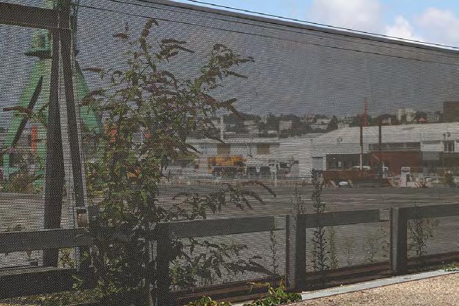
2 B.1. HIGHLIGHT THE TRANSITIONAL ELEMENTS BETWEEN CITY AND PORT Special attention must be paid to the development of the urban/port interface, and to the links between these two worlds (bridges, footpaths, etc.). This includes making a careful choice of materials for visible surfaces, installing adequate urban and port equipping, and generating thoughtful designs to create an interesting transition between the two sectors. LE HAVRE (FRANCE) On one edge of the Eure district, residential units have been built in close proximity to ship-repair facilities. Special attention was paid to the boundaries between the two areas: rather than building a traditional type of fence, the planners chose a carefully-designed metal screen. The landscaping along the 250 m of the screen softens its lines, making for a more attractive visual aspect and allowing views of the ship repair activities. The fence also complies with international standards relating to security in port areas (ISPS code). 28
3 Governance 29 29

")
4 BRUSSELS (BELGIUM) In Brussels, the emphasis on architectural and urban integration extends to the entire port area. In 1996, the Port of Brussels signed a "Development Charter" with the companies operating at the port. The document was updated in Under the charter, the parties undertake to modernise their installations in keeping with the urban environment, paying special attention to the vicinity (signage, green areas, access, fencing, maintenance, etc.) and the architecture itself (recommendations on colours, materials, dimensions, etc.). This global approach ensures visual continuity and harmony between the various port infrastructures, while making the port a more visitor-friendly environment and asserting its presence. The most recent example is the "Construction Village", due to be developed by 2016 on the left shore of the Vergote dock basin. It will reduce heavy vehicle traffic by carrying construction materials directly to the heart of the Belgian capital. Requirements also covered the quality of urban and architectural integration, which resulted in the project being awarded to the firm Tetra Architecten. In recognition of its design, combining recycling, logistics hub and urban integration, it was awarded the Holcim Foundation's 2014 international sustainable development prize). Illustration Construction Village Copyright: Tetra Architecten BVBA Illustration Construction Village Copyright: Tetra Architecten BVBA 30


 It forms an attractive reference point with its spectacular design, 13.")


5 B.2. SHOWCASE PORT CITY LANDMARKS AND SCENERY At the border between land and sea, the urban/port landscape offers a rich, specific spectacle that combines the technical elements associated with port functions, dock basins and shipping, with typically urban views. The topography of port cities frequently provides natural viewing platforms or allows for paths overlooking this spectacle, creating unity between the active port and the city. But these views can also be deliberately planned during the design stage of projects, by including roof terraces or creating specific viewpoints. HAMBURG (GERMANY) It forms an attractive reference point with its spectacular design, metre height and orange colour. The building's shape is reminiscent of both a periscope and the outline of the port cranes. Its upper platform has capacity for up to 25 people, allowing them to enjoy the spectacle of a fast-growing city undergoing extensive redevelopment, and an active port. Governance The view point created at the foot of the "Marco Polo" tower and close to the cruise terminal commands 360 panoramic views of the Hafen City and Hamburg, the river, and the port areas located on the far bank. Both the view point and the cruise terminal were built in 2004 by Hamburg firm RHW Architekten. The 120,000 euro cost of the building was partly financed by local communities as part of the EU's NORTHSEA- INTERREG III B programme


6 MELBOURNE (AUSTRALIA) In 2013, the Port of Melbourne ordered the start of work to reconfigure the Webb Dock area in the south-west of the city, along with the construction of a container terminal with a minimum capacity of up to 1 million TEUs per year. The creation of a "waterline" forms an integral part of the project. It involves building and/or redeveloping buffer zones around this port area, to promote its integration within the expanding city. Independent experts have assessed its visual impact from twelve different view points. On one side of the Webb Dock East, the "Web Trail" will be created. This promenade for pedestrians and cyclists will provide access to an observation platform called Webb Point, with commanding views of the bay and the city, as well as the container ships at sea and in the terminal. The waterline project was submitted for consultation and public feedback in 2013, and work began at the end of that year. Copyright: Port of Melbourne Webb Point, Future Observation Deck Copyright: Port of Melbourne 32

7 B.3. CONCEIVE A TYPE OF SPATIAL ORGANISATION WHICH ALLOWS OR PRESERVES SCENIC VIEWS OF THE PORT AND THE WATER Occupied and empty spaces, visual perspectives, building heights and volumetric shapes are all factors that can be altered in order to optimise the way city/port interface sites are integrated into the existing urban and port context. With careful planning, it is possible to preserve and/or create visual perspectives of the water, dock basins, reclaimed port patrimony, the port and its activities. LE PORT (REUNION ISLAND FRANCE) When it was founded in 1895, Le Port was originally a sole-purpose city, a tool organised specifically to further the economic development of the port and designed exclusively for the shipping of goods. During the 1960s, a dividing line gradually came to separate the city from the port and the sea. The railway closed down and buildings were erected around the dock basins, forming a physical and symbolic boundary with the city. The election of a new city government in 1971 marked a change. The first master plan ushered in a new approach to planning, centred on a commitment to creating a green, ocean-facing city. The new initiative was based on a major land acquisition programme that extended to over 75% of the territory. It inspired a project dubbed "Ville et Port, la ville est port" (City and Port, the city is the port), which in March 2000 led institutional partners to adopt a charter for its implementation. Governance With the objective being to break down the barriers between the city and its port, a radically new approach was required. The challenge was to transform the purely functional city, originally designed for the sole purpose of shipping, and to adopt a more permeable design with a new traffic layout and open spaces, opening up the waterfront area which would become a new point of interest in its own right. Another challenge involved consolidating the city to cope with population growth (from 40,000 residents to an expected 60,000 by 2020) in a limited space, while achieving energy self-sufficiency by «Mail de l Océan» Copyright: City of Le Port One of the major developments in response to these issues is the creation of a central thoroughfare, the "Mail de l Océan", on which work began in spring It now runs through the city for 2 km from east to west. The new road will culminate at the Pointe des Galets, a public space designed around the three "Grandes maisons", large colonial-style houses, one of which may be turned into a museum. Overlooking the quays, there are plans for small blocks combining housing and shops. To satisfy the requirement for permeability, these blocks will be laid out in such a way as to preserve views of the port for neighbouring streets, while the buildings' facades will be staggered down to the new sea front


8 From the purely functional to the permeable Copyright: City of Le Port Volumetric view from the City Copyright: Agence Ter HAIFA (ISRAEL) The city of Haifa has lost its access to the sea since the port was built in the 1930s. Its narrow quays are now obsolete and most of the port activity has been relocated elsewhere. A dynamic new urban space to attract businesses and investors is planned, with priority on public spaces and a commitment to maintaining the port's identity. A vast open public space will be created along a 2 km promenade. The remaining warehouses, along with new buildings constructed in the same vein, will house cafés, restaurants, small hotels, offices and cultural activities. These structures will retain their original industrial character, in perfect harmony with the nearby cranes and overhead conveyors used for cereals. Limits on the height of all the structures along the coast will preserve the beauty and extent of the sea views from the city heights (and in particular from the famous Bahai hanging gardens). 34


9 Eight City-Port Connectors. First Stage Copyright: Ami Shinar, Amir Mann - Architects & Planners The plan was approved on January 2015 by the National Planning Council. The train track that separates the city and the port does, however, represent a major obstacle for the project. The Council also decided that it will be depressed. By way of an interim solution, two "bridge-buildings" will be constructed to act as the main gateway to the new promenade. They will remain in service once the railway line has been buried. Governance After Before 35 35


10 Before First Stage- train track still present Ben Gurion plaza from west, final stage, with train depressed Copyright: Ami Shinar, Amir Mann - Architects & Planners 36


 In Le Havre's port districts, the green spaces of the \"riverside gardens\" along a")


11 B.4. CREATE URBAN / PORT / GREEN BUFFER AREAS The creation of buffer areas between the existing or future urban front and the port activity allows the city and port to coexist more easily, while also providing living space. There are a variety of possible solutions: Urban buffer areas, containing infrastructures compatible with the port activity: offices, small businesses, cultural facilities, etc. Port buffer areas containing low-impact port facilities: small-scale logistics, river traffic linked to the urban economy, a base for vessel services, river boat "parks", etc. Green buffer areas obtained either by preserving predominantly rural zones or by creating new green spaces. LE HAVRE (FRANCE) In Le Havre's port districts, the green spaces of the "riverside gardens" along a former canal have been renovated to provide a transitional area between the city and the ship repair activities and coldstorage warehouses opposite. The site commands views of an active port while acting as a buffer zone, ensuring the physical distance necessary for port and urban activities to coexist in harmony. It also provides a leisure and living space in the heart of a district that contains both residential units and small businesses. Governance The area has been landscaped in a way that maintains the link to its industrial and port heritage (with some rails being retained, paving stones used, etc.), thereby helping to preserve its identity and attractiveness
A.1. REDEVELOP THE PORT WITHIN ITS EXISTING BOUNDARIES Space SPACE Worldwide, many ports are faced with a lack of available space as a result of diffe
 A. A.1. REDEVELOP THE PORT WITHIN ITS EXISTING BOUNDARIES A.2. SHARE THE USE OF THE WATER AND WATERFRONT BETWEEN URBAN AND PORT FUNCTIONS A.3. MIX URBAN AND PORT FUNCTIONS A.4. MOVE THE CITY TO THE WATER
BEST PRACTICES IN IMPROVING PORT/CITY RELATIONSHIP
 BEST PRACTICES IN IMPROVING PORT/CITY RELATIONSHIP COMMERCIAL COMMUNITY MANDATE ENSURE THE PORT S SUSTAINABILITY COMMERCIAL COMMUNITY MAKE THE PORT PART OF THE COMMUNITY : IMPROVED COEXISTENCE Implement
Page 1 of 19 URBAN DESIGN FRAMEWORK FOR BOLTON STREET WATERFORD
 Page 1 of 19 URBAN DESIGN FRAMEWORK FOR BOLTON STREET WATERFORD 1.0 Introduction: The relocation of the City Council stores and depot from Bolton Street creates an exciting opportunity for development
Sheffield Victoria Station Development Prospectus January 2014
 6 Billion extra GVA growth for Sheffield City Region s economy Sheffield Victoria Station Development Prospectus January 2014 Document produced by Sheffield City Council Introduction The construction of
6.0 Development of Amenities,
 6.0 Development of Amenities, conservation of architectural heritage and other features This chapter outlines the Area's significant potential to provide for amenities of city wide and local importance
heuston gateway: sections heuston gateway: regeneration strategy and development framework plan
 B B1 A B1 B C A heuston gateway: sections B B1 C 117 4.3.3 Zoning The station is the central hub of the area and this function must be preserved and developed. However large areas of the Heuston Station
Overview Report. Proposed Development
 Overview Report Proposed Development the construction of a 1km cycle/pedestrian trail including a new footbridge, new car park and entrance road at Drumshanbo Lock and a new pedestrian/cycle road crossing,
ROME WATERFRONT VILLAGE PROJECT NARRATIVE January 25, 2018
 January 25, 2018 The Rome Waterfront Village project is intended to foster the revitalization of the area between South James Street and Erie Boulevard north of the Erie Canal as well as improve public
City of Heath. Town Center Concept
 In the give-and-take of getting projects designed, financed, and approved, the famous refrain from the film Field of Dreams is heard often: if you build it, they will come. From the perspective of the
13. London Bridge London Bridge Area Vision
 13. 13.1. Area Vision 13.1.1. is: A globally significant central London business district which is home to international business headquarters; Internationally renowned for its prominent riverfront location
Sub-committee on Harbour Plan Review of Harbour-front Enhancement Committee. Ninth Meeting
 Sub-committee on Harbour Plan Review of Harbour-front Enhancement Committee Ninth Meeting Date: 5 October 2005 Time: 3:30pm Venue: Conference Room 15/F, North Point Government Offices, 333 Java Road, North
7.2.9 Eudlo local plan code
 7.2.9 local plan code 7.2.9.1 Application (1) This code applies to assessable development:- (a) within the local plan area as shown on Map ZM29 contained within Schedule 2 (Mapping); and (b) identified
Official Community Plan Bylaw No. 4360, 2004, Amendment Bylaw No. 4897, 2016 (Sewell s Landing)
") District of West Vancouver Official Community Plan Bylaw No. 4360, 2004, Amendment Bylaw No. 4897, 2016 (Sewell s Landing) Effective Date: 1089612v1 District of West Vancouver Official Community Plan Bylaw
District of West Vancouver Official Community Plan Bylaw No. 4360, 2004, Amendment Bylaw No. 4897, 2016 (Sewell s Landing) Effective Date: 1089612v1 District of West Vancouver Official Community Plan Bylaw
BLOK BADEL ZAGREB. Competition for the urban-architectural concept design for the BADEL SITE redevelopment COMPETITION NUMBER: ZG-UA
 BLOK BADEL ZAGREB Competition for the urban-architectural concept design for the BADEL SITE redevelopment COMPETITION NUMBER: 136-12-ZG-UA 1.0 DESCRIPTION AND EXPLANATION OF THE OVERALL CONCEPT The Badel
Ringsend & Irishtown Local Environmental Improvement Plan
 Ringsend & Irishtown Local Environmental Improvement Plan Study Area East Link Bridge St. Patrick s Boat Club Ringsend Technical Institute Stella Maris Boat Club St. Patrick s Church Ringsend Library Ringsend
milano santa giulia Our Project, Your Retail
 milano santa giulia Our Project, Your 2 A new city district for a global city population density 3 Milan is the most populous city in Italy and the country s main industrial, financial and commercial centre,
WELCOME. Welcome to our second public exhibition on proposals for the redevelopment of the Paddington Central Management Office.
 WELCOME Management Office Paddington Central Welcome to our second public exhibition on proposals for the redevelopment of the Paddington Central Management Office. Following feedback from meetings with
Westwind Developments Ltd. PIONEER LANDS AREA STRUCTURE PLAN - PROPOSED AMENDMENT
 FEBRUARY 2013 TABLE OF CONTENTS 1.0 BACKGROUND... 1 1.1 Amendment... 1 2.0 LOCATION & CONTEXT... 2 2.1 Land Ownership... 2 3.0 POLICY CONTEXT... 3 3.1 Municipal Development Plan... 3 3.2 Capital Region
Welcome THE SITE PHASE 1 EXCLUSION ZONE.
 THE SITE PHASE 1 Aerial view of the whole site with Phase 1 indictated Welcome Barratt London and Hyde Group are working with Pollard Thomas Edwards on redevelopment proposals for Harrow View East, part
THE LIGHT RAIL GRAND PASSAGE A LINEAR GARDEN
 Attention to Vision42design Project Competition Jury: The proposal: THE LIGHT RAIL GRAND PASSAGE A LINEAR GARDEN Alfred Peter - Landscape Architect* Charles Bové - Designer** Karen (Bloch) Listowsky -
Welcome. Community Consultation Meeting November 28, Review and discuss the Bathurst Quay Neighbourhood Plan Framework
 Welcome Community Consultation Meeting November 28, 2016 Why Are We Here Today? Review and discuss the Bathurst Quay Neighbourhood Plan Framework Review and discuss an Action Plan for Implementation Next
WELCOME. ORPINGTON. Welcome to this exhibition of our proposals for the redevelopment of Bassetts Campus.
 WELCOME Welcome to this exhibition of our proposals for the redevelopment of Bassetts Campus. The site has been vacant since 2013 and in 2014 NHS Property Services previously brought forward plans for
28. Coolaney-Rockfield Mini-Plan
 28. Coolaney-Rockfield Mini-Plan 28. Coolaney-Rockfield Mini-Plan Community facilities Community facilities in Coolaney-Rockfield consist of a primary school, crèche, community centre, sports field and
17. Coolaney-Rockfield Mini-Plan
 County Development Plan 2017-2023 Consolidated Draft + Adopted Amendments - August 2017 17. Coolaney-Rockfield Mini-Plan Village profile Coolaney is located approximately 23 km to the south-west of Sligo
Highland Falls Waterfront Redevelopment Feasibility Study Village Board Meeting March 20, 2017
 Village Board Meeting March 20, 2017 Agenda I. Public Meeting #1 Visioning Summary II. Public Meeting #2 Comment Summary III. IV. IV. Case Study: Milton Train Station Schematic Design Concepts Schedule/Next
QUEEN-RIVER SECONDARY PLAN
 34 QUEEN-RIVER SECONDARY PLAN 34. QUEEN RIVER SECONDARY PLAN 1. INTRODUCTION The Queen-River area is approximately 6.4 hectares and is located at the eastern edge of the Downtown as shown on Map 34-1.
30. Riverstown Mini-Plan
 County Development Plan 2017-2023 Consolidated Draft + Adopted Amendments August 2017 Volume 2, Chapter 30 Riverstown Mini-Plan 30. Riverstown Mini-Plan Village profile Riverstown is located approximately
TOWN COUNCIL / PLANNING COMMISSION
 Workshop #3 TOWN COUNCIL / PLANNING COMMISSION January 20, 2011 Consultant Team In Attendance Tonight BMS Design Group Nevada City and San Francisco Michael Smiley, AICP, ASLA Partner-in-Charge Nancy L.
Location: Netherlands Area : m 2
 Prison Museum Landscape Design: Buro Lubbers Location: Netherlands Area : 15.500 m 2 Morden Style Culture and Education Photography: Buro Lubbers The characteristic, orthogonal structure of Veenhuizen
KHARTOUM GARDEN CITY. Dietmar Kamphans
 KHARTOUM GARDEN CITY Dietmar Kamphans As most cities in the world have been set up at river banks and sea shores, even Khartoum is located at the confluence of the Blue and White Nile. Beside the regular
JACKsON STREET PIER CONCEPTUAL DESIGN PACKAGE SEPTEMBER 21, 2017
 JACKsON STREET PIER CONCEPTUAL DESIGN PACKAGE SEPTEMBER 21, 2017 JACKsON STREET PIER Process outline DESIGN PROCESS OVERVIEW: Sandusky s Jackson Street Pier Conceptual Design process included input from
H7 Open Space zones. (a) provide for the needs of the wider community as well as the needs of the community in which they are located;
 provide for the needs of the wider community as well as the needs of the community in which they are located;") H7. Open Space zones H7.1. Background The majority of land zoned as open space is vested in the Council or is owned by the Crown. However some areas zoned open space are privately owned. While the open
H7. Open Space zones H7.1. Background The majority of land zoned as open space is vested in the Council or is owned by the Crown. However some areas zoned open space are privately owned. While the open
Duplex Design Guidelines
 Duplex Design Guidelines Adopted by Council May 29, 2006 Prepared By: Table of Contents 1.0 Application and Intent 1 2.0 Areas of Application 2 3.0 Design Principles 3 4.0 Design Guidelines 4 4.1 Site
Former North Works, Lickey Road, Longbridge, Birmingham
 Committee Date: 14/11/2013 Application Number: 2013/06431/PA Accepted: 27/08/2013 Application Type: Full Planning Target Date: 26/11/2013 Ward: Longbridge Former North Works, Lickey Road, Longbridge, Birmingham
REPORT BACK BROADSHEET 3 May 2016
 Paddington Place REPORT BACK BROADSHEET May 06 Architects and planners should work with the community first and then thinking about developers profits second. - Quote from participant at Paddington Place
PORT OF VANCOUVER WATERFRONT DEVELOPMENT. Concept Development Plan City Center Redevelopment Authority April 20, 2017
 PORT OF VANCOUVER WATERFRONT DEVELOPMENT Concept Development Plan City Center Redevelopment Authority April 20, 2017 Port History PORT ESTABLISHED 1912 TERMINAL 1 ACQUIRED 1925 GWM SIGNS LEASE 1935 HARBOR
Highest & Best Use Study Marina Park Lands
 Executive Summary of Report MARCH 2006 TABLE OF CONTENTS 1. Introduction...1 2. Study Process...2 3. Highest And Best Use Program...3 4. Concept Plan...8 5. Public Area Animation...9 6. Marina Park Implementation
BRADENTON RIVERWALK EXPANSION MASTER PLAN
 BRADENTON RIVERWALK EXPANSION MASTER PLAN INTRODUCTION & AGENDA Process Update Community Engagement Summary Center for Active Design (CfAD) Recommendations Context and Existing Conditions Master Plan Alternatives
DRAFT ROOSEVELT ROAD. District Recommendations. Figure 5.23 The Roosevelt Road Corridor
 CHAPTER 5 Figure 5.23 The Road Corridor Road will develop as a mixed-use corridor, emphasizing regional retail, west of the river and mixed-use development east of the river. KEY RECOMMENDATIONS 1. High
SCHEDULE 12 TO THE DESIGN AND DEVELOPMENT OVERLAY GLEN WAVERLEY ACTIVITY CENTRE STRUCTURE PLAN
 DD/MM/YY Proposed C120 SCHEDULE 12 TO THE DESIGN AND DEVELOPMENT OVERLAY Shown on the planning scheme map as DDO12. GLEN WAVERLEY ACTIVITY CENTRE STRUCTURE PLAN 1.0 Design objectives DD/MM/YY Proposed
Barnstaple's new riverside quarter
 Artist's impression of completed site Welcome to our exhibition of plans for new homes and commercial phases 2a and 2b of Anchorwood Bank. Anchorwood Bank is the most important development site in Barnstaple.
5.0 P A R K R E C O M M E N D A T I O N S
 5.0 P A R K R E C O M M E N D A T I O N S 5.1 Confederation Park The analysis of Confederation Park recognizes that it, along with City Hall, is the symbolic heart of Kingston. While the existing layout
Welcome to our public exhibition on London Square s plans to redevelop the B&Q site on Smugglers Way. from Monday 10th October 2016.
 WELCOME Welcome to our public exhibition on London Square s plans to redevelop the B&Q site on Smugglers Way. Aerial view of existing site Our plans are for a mixed use development which will provide new
chapter DESIGN GUIDELINES NEW RIVER MASTER PLAN REPORT
 chapter DESIGN GUIDELINES NEW RIVER MASTER PLAN REPORT .76 DESIGN GUIDELINES An Overview design guidelines NEW RIVER MASTER PLAN Design Guidelines can transform the image of a city. Specific, design-based
Chapter 2, Section C: Urban Design and Visual Resources A. INTRODUCTION
 Chapter 2, Section C: Urban Design and Visual Resources A. INTRODUCTION This attachment considers the potential of the proposed East River Waterfront Access Project at Peck Slip to effect urban design
Online Survey Results 1 Port Street East
 Online Survey Results 1 Port Street East Inspiration Port Credit is about envisioning a bright, new future for the Port Credit waterfront. Through an online survey in the fall of 2014, we asked what the
SQUAMISH 2010 AND BEYOND COMMUNITY VISION
 Our plan has been imagined and created to be both pragmatic and visionary. At the core of the strategy is a consideration of the highway s role and its impact on the community. First and foremost in creating
PRELIMINARY DESIGN + DEVELOPMENT PLAN
 WELCOME! To The Public Open House May 30 th, 2017 HARBOUR WEST PARKS Vision Project Overview The City s vision for Port Credit Harbour West Parks is to develop a vibrant waterfront destination that integrates
Prepared by: a for the of the. Waterspace Strategy Sustainable Development Liverpool South Docks
 Prepared by: a for the of the Waterspace Strategy Sustainable Development Liverpool South Docks a Waterspace Strategy for the Sustainable Development of the Liverpool South Docks British Waterways identified
7-PARKS, OPEN SPACE & PUBLIC ART
 7-s, Open Space & Public Art 7-PARKS, OPEN SPACE & PUBLIC ART This chapter provides recommendations for the expansion of new parks, plazas and open space that serve the many user groups targeted for downtown.
The Dreispitz in Basel / Switzerland: New economy on old sites
 The Dreispitz in Basel / Switzerland: New economy on old sites 1. Introduction At 50.000m 2 Dreispitz is currently the largest and most ambitious development project in Basel, the second biggest town in
DRAFT. Waterfronts and Open Spaces. 10 The Riverfront Open Space System
 CHAPTER 4 Waterfronts and Open Spaces 10 The Riverfront Open Space System 12 Planned, proposed and envisioned riverfront recommendations. Figure 4.3.23 The riverfront will become a major new public amenity
141 GEORGE STREET PLANNING RATIONALE
 141 GEORGE STREET PLANNING RATIONALE MINOR ZONING BY-LAW AMENDMENT NOVEMBER 2, 2016 PLANNING RATIONALE 223 McLeod Street Ottawa, ON K2P 0Z8 613.730.5709 fotenn.com INTRODUCTION FOTENN Consultants is acting
County Development Plan Consolidated Draft + Adopted Amendments August 2017 Volume 2, Chapter 22 Easky Mini-Plan
 22. Easky Mini-Plan Village profile Easky is a coastal settlement located approximately 40 km to the west of Sligo City, in a designated Rural Area In Need of Regeneration. The nearby coastline is designated
Queensborough Eastern Neighbourhood Node. Community Open House
 Queensborough Eastern Community Open House The Vision The Queensborough Eastern will become the heart of eastern Queensborough. Through a sensitive mix of viable commercial and residential areas, the neighbourhood
DUBLIN DOCKLANDS MASTER PLAN AND RELATIONSHIP WITH OTHER PLANS
 .1 National Policy and Programmes.1.1 Sustainable Development A Strategy for Ireland, 1997.1.2 National Climate Change Strategy, 2007-2012.1. National Development Plan 2007-201.1.4 National Spatial Strategy,
Title: South Britannia Community Centre Tobi Fenton
 Title: South Britannia Community Centre Tobi Fenton South Britannia is laid out in a grid of 120x60 meter blocks with Main Street oriented towards Howe Sound. The concentrated centre is located at the
Preliminary Sketch Plan for Fort Hunter Park
 Preliminary Sketch Plan for Fort Hunter Park Public Presentation November 19, 2009 Dauphin County Parks and Recreation 100 Fort Hunter Road Harrisburg, PA 17110 (717) 599-5188 www.dauphinc.org THOMAS COMITTA
Nepean Point CONSULTATION REPORT JUNE 2014
 Nepean Point CONSULTATION REPORT JUNE 2014 Workshop: Nepean Point I Project description Objective: With the renewal of Nepean Point, the National Capital Commission (NCC) presented a project to develop
Final Master Plan and Development Control Regulations
 1. INTRODUCTION CHECK LIST a. Introduction b. Table of contents c. Definitions. d. scope of works. 2. FINAL OVERALL MASTER PLAN a. SITE ANALYSIS and OVERVIEW: i. Existing and Proposed Site Plan Levels.
URBAN DESIGN BRIEF REPORT
 URBAN DESIGN BRIEF REPORT PREPARED FOR 2568401 ONTARIO INC NEW GASBAR, CONVENIENCE STORE & CARWASH DEVELOPMENT @ 1509 FANSHAWE PARK ROAD WEST LONDON, ONTARIO GAMA ENGINEERING INC. PROJECT NUMBER 1669 PREPARED
Vision for Irvine: a self-confident town where people aspire to live and work and which they are proud to call home
 Vision for Irvine: a self-confident town where people aspire to live and work and which they are proud to call home Stunning view out to the harbourside Artist s impression of how the Bridgegate area could
London Bridge London Bridge Area Vision Map
 Area Vision Map Borough Market Southwark Cathedral NSP54 Hay s Galleria Key: NSP Site Allocations Greenspace Low Line Thames Path Cycle Network Primary Shopping Areas Borough High Street Tube Station NSP51
Table 8-4: Road Classification Local Roads, second table, of Chapter 8 Create a Multi-Modal City, be amended by adding the following:
 1 Port Street East Official Plan Amendment APPENDIX 3 Amendments to Mississauga Official Plan Table 8-4: Road Classification Local Roads, second table, of Chapter 8 Create a Multi-Modal City, be amended
5. Bankside and The Borough 5.1. Bankside and The Borough Area Vision
 5. 5.1. Area Vision 5.1.1. are: A globally significant central London business district which is home to international business headquarters; At the heart of the commercial and cultural life of the capital
Marinas, Mooring and Boating Facilities 23
 195 Marinas, Moorings and Waterfronts 23.1 The valleys of the River Severn, River Avon, River Teme and their tributaries significantly define the natural character of South Worcestershire, whilst the canal
Regional Context Statement
 Regional Context Statement REGIONAL CONTEXT STATEMENT 3. REGIONAL CONTEXT STATEMENT In 1995, the Provincial Government passed into law the Growth Strategies Act. The purpose of this provincial initiative
Colchester Northern Gateway Master Plan Vision Review Draft. July 2016
 Colchester Northern Gateway Master Plan Vision Review Draft July 2016 Contents Introduction 4 Context 8 Purpose of the Report 8 Strategic Position 9 Overview of the Process 11 2012 Master Plan Vision 12
I539. Smales 2 Precinct
 I539. Smales 2 Precinct I539.1. Precinct Description The Smales 2 Precinct applies to a 4.8 hectare block of land located on the southern side of Northcote Road and fronting Lake Pupuke, Takapuna. The
Waterfronts vs cities: Some urban and territorial considerations
 Waterfronts vs cities: Some urban and territorial considerations The waterfront concept The waterfront concept A part of a town which is next to an area of water such as a river or the sea. Waterfronts,
Chapter 5 Urban Design and Public Realm
 5.1 Introduction Public realm is all areas of the urban fabric to which the public have access. It is where physical interaction takes place between people. It therefore, includes buildings and their design,
The Proposed Auckland Unitary Plan (notified 30 September 2013)
") 3 Business zones Introduction There are 10 business zones in the Unitary Plan: City Centre Metropolitan Centre Town Centre Local Centre Neighbourhood Centre Mixed Use General Business Business Park Light
3 Business zones Introduction There are 10 business zones in the Unitary Plan: City Centre Metropolitan Centre Town Centre Local Centre Neighbourhood Centre Mixed Use General Business Business Park Light
Port Credit Local Advisory Panel October 20 th Meeting
 Port Credit Local Advisory Panel October 20 th Meeting Focus Of This Evening s Meeting: 1. Hurontario Main Street Higher Order Transit Study 2. Port Credit Mobility Hub & GO Station Parking Structure Study
Downtown North Las Vegas Demonstration Site Project. Project Update
 Downtown North Las Vegas Demonstration Site Project Project Update 7.16.14 Presentation Overview Project Purpose and Process Planning Context Opportunities and Barriers Summary Community Input Preliminary
Moving from Vision to Action
 Moving from Vision to Action Photo: John Carvalho What does it mean for a city to move? To see its people belong and connect? To prosper? To become green? Those are the pillars that are helping Mississauga
Los Angeles Harbor Commission Approves a New Wilmington Waterfront
 At the Port of Los Angeles Los Angeles Harbor Commission Approves a New Wilmington Waterfront In June, the Los Angeles Harbor Commission approved the Wilmington Waterfront Development Project. The project
Hockessin Community Redevelopment Plan
 Hockessin Community Redevelopment Plan 3.1 Introduction The Community Redevelopment Plan for the Village of Hockessin is the result of the people s vision for a distinct village center that serves as the
CULTURAL POLICIES AND AGENDA 21 IN BAIE-SAINT-PAUL
 CULTURAL POLICIES AND AGENDA 21 IN BAIE-SAINT-PAUL 1. Context Founded over 350 years ago, the 'Art and Heritage town' of Baie-Saint-Paul is nestled in a valley crossed by the Gouffre and Bras rivers and
SARANAC LAKE VISION CONCEPTS
 DRAFT SARANAC LAKE VISION CONCEPTS A GENUINE PLACE TO LIVE, WORK, SHOP AND EXPERIENCE CULTURE IN THE HEART OF THE ADIRONDACKS PHOTO COURTESY OF SARANAC LAKE SARANAC LAKE, NEW YORK DECEMBER 2007 SARANAC
UNIVERSITY TOWN NEIGHBOURHOODS 5.5 HOUSING MELBOURNE CAMPUS MASTER PLAN 2014
 5.5 169 EXISTING CONDITIONS & VISION NEIGHBOURHOOD VISION The provision of on-campus housing into the future will continue to be an important element of the La Trobe University experience. A long-term
Creating an integrated waterfront. Recommendations
 Creating an integrated waterfront Recommendations Railway Square Post Office + Shell Station Post Office Square Civic Square Ilot Green Wakefield St Wakefield St (Tory Cars) Wakefield St (New World Supermarket)
M i s s i o n B a y W a t e r f r o n t
 114 M i s s i o n B a y W a t e r f r o n t Character of the Area: The Mission Bay Waterfront extends from Pier 48 at China Basin Channel to 18th Street in the Central Basin. This area of the waterfront
New-Cast Mixed-use Development Proposal King Street West, Newcastle, Ontario
 URBAN DESIGN BRIEF New-Cast Mixed-use Development Proposal King Street West, Newcastle, Ontario TABLE OF CONTENTS: 1.0 Executive Summary 2.0 Creating Vibrant and Sustainable Urban Places: Excerpts from
Our City Centre is a vibrant, creative and welcoming destination, with a modern business, cultural, shopping, leisure and residential offer
 3. Sheffield in 2034 Our City sits at the heart of a strong, distinctive and internationally successful City Region economy which supports innovation and enterprise Our City Centre is a vibrant, creative
WATERFRONT PLACE CENTRAL MIXED USE REDEVELOPMENT PROJECT
 WATERFRONT PLACE CENTRAL MIXED USE REDEVELOPMENT PROJECT View Impact Analysis - Summary Narrative The view impact analysis conducted for the Waterfront Place Central mixed-use redevelopment project proposal
Published in March 2005 by the. Ministry for the Environment. PO Box , Wellington, New Zealand ISBN: X.
 Action Pack Published in March 2005 by the Ministry for the Environment Manatū Mō Te Taiao PO Box 10-362, Wellington, New Zealand ISBN: 0-478-18994-X ME number: 580 This document is available on the Ministry
THE BASQUE DECLARATION TRANSFORMATIVE ACTIONS TO CREATE MORE PRODUCTIVE, SUSTAINABLE AND RESILIENT CITIES
 THE BASQUE DECLARATION TRANSFORMATIVE ACTIONS TO CREATE MORE PRODUCTIVE, SUSTAINABLE AND RESILIENT CITIES Historical Background The Basque Declaration and global agreements Transformative actions The process
ISOCARP YPP Workshop Perm, September YPP Workshop Perm 2012
 PERM ПЕРМЬ ISOCARP YPP Workshop Perm, 6. 9. September 2012 Approved Masterplan Process: team building, identifying topics, developing solutions Deficits Deficits Assets Assets Using the assets to improve
Corridor Enhancements
 Corridor Enhancements Safety is MoDOT s first priority in widening and rebuilding I-70 across the state of Missouri. MoDOT also understands that the interstate - and its interchanges and overpasses - are
EVALUATION OF MASTER PLAN ALTERNATIVES
 7 The Environmental Report is required to identify, describe and evaluate reasonable alternatives, taking into account the objectives and geographical scope of the Master Plan 2008. Three plan alternatives
Some thoughts for a sustainable tourism development strategy for Sanshui District of Foshan City
 Some thoughts for a sustainable tourism development strategy for Sanshui District of Foshan City Dr. Werner Breitung School of Geography and Planning Sun Yatsen University breitung@gmail.com [Prepared
Strasbourg SUMP Award: Finalist factsheet. Local Transport facts. Urban transport policy objectives of the city:
 Strasbourg 2013 SUMP Award: Finalist factsheet Local Transport facts Name of the authority: Urban Community of Strasbourg, FR Website: www.strasbourg.eu Contact: Maeva Moreau Telephone: +33 388436514 Email:
CHONGMING ISLAND SHANGHAI CENTRAL CITY
 Chongming Island CHONGMING ISLAND SHANGHAI CENTRAL CITY Chongming Island Shanghai, China THE VISION: A GREEN ISLAND Chongming Island benefits from a magnificent setting, adjacency to the vibrant center
Design & Access Statement
 PI 007 RIBA Chartered Architects Design & Access Statement Ocean Beach Pleasure Park South Shields 1.0 Appraising the Context 1.1 Assessment of the sites immediate and wider context 1.2 Involvement Consultation
PROPOSED URBAN STRUCTURE
 CHAPTER 3 PROPOSED URBAN STRUCTURE PLANNING PARTNERS: CENTURY CITY URBAN DESIGN FRAMEWORK October 2005 13 THE PROPOSED URBAN STRUCTURE The urban design rationale outlined in the previous chapter provides
SA N T I AG O D ES EA D O 1 AILET S U STA I N A B L E C I T Y S I M U L ATO R R A 710/21/161
 SANTIAGO DESEADO SUSTAINABLE CITY SIMULATOR 16/11/2017 1 AN EXPANDING GROUP IN FRANCE 3,600 39 offices INTERNATIONAL 1,400 35 countries TURNOVER 539m 16/11/2017 2 & INDIA 2011 BUILDING & INDUSTRY WATER
Bel-Air Lexus Automobile Service Station
 Bel-Air Lexus Automobile Service Station Design Brief 443-447 McArthur Avenue Ottawa April 30, 2015 14-1299-MCA Site Details Application: Site Plan Control Legal Description and Municipal Addresses: 443
Rotherhithe Rotherhithe Area Vision Map
 Area Vision Map CWAAP1 Improved pedestrian and cycle links to the wider area Improved link from town centre to River Thames and docks CWAAP2 Brunel Museum NSP79 CWAAP3 Proposed Thames Crossing Station
PUBLIC REALM STUDY AREA
 WELCOME PUBLIC REALM STUDY AREA WHAT IS PUBLIC REALM? Welcome to the Ballina Town Public Realm public consultation event. Mayo Council is in the process of producing a Public Realm Strategy for Ballina
REMARKABLES PARK ZONE
 .10 Remarkables Park Zone.10.1 Resources, Activities and Values The Remarkables Park Area comprises approximately 150 hectares of perimeter urban land in the vicinity of Frankton and occupies a strategic