SOUTH EAST LINCOLNSHIRE LOCAL PLAN: HOUSING PAPER DONINGTON (JUNE 2016)
|
|
|
- Ezra Francis
- 6 years ago
- Views:
Transcription
1 SOUTH EAST LINCOLNSHIRE LOCAL PLAN: HOUSING PAPER DONINGTON (JUNE 2016) 1 DONINGTON S PLACE IN THE SPATIAL STRATEGY 1.1 Policy 2 of the South East Lincolnshire Local Plan Draft for Public Consultation (January 2016) identified Donington as a Main Service Centre. 1.2 Comments received - No comments were received relating to Donington s place in the Spatial Strategy. 1.3 Given the lack of challenge made to Donington s place in the Spatial Strategy, it is considered that it should remain as a Main Service Centre. 2 DONINGTON S HOUSING REQUIREMENTS 2.1 Policy 12 of the South East Lincolnshire Local Plan Draft for Public Consultation (January 2016) identified that housing allocations should be made in Donington to provide for 380 dwellings between April 2011 and 31 st March Comments received - The following comments were received concerning Donington s housing requirements: new houses in Donington in the plan period should allow for flexibility in the number of new housing allocations, (the 2014 SHMA had previously indicated housing numbers of 560 dpa for the South Holland area); 2. because Donington has a good sustainability rating and level of facilities, it should be allocated more than 380 new homes (to accommodate current immigration increases and the need for better integration of immigrants); 3. the local infrastructure (schools, doctors, hospital, dentists, local roads, shops, bus services, and sewers) cannot accommodate the demand that will be generated by an additional 380 dwellings; and 4. support the allocation of 380 dwellings in the Main Service Centre of Donington it is appropriate given the range of services and facilities that are available in the settlement. 2.3 Responses to the above comments: 1. the housing figures identified are a minimum requirement the Plan includes generous provision to ensure that the area s housing needs will be met in a flexible way, namely:
2 o o o it assumes that sites in Donington will be developed at a density of just 20 dwellings to the hectare, whereas the reality is that most sites will be developed at a higher density; it does not include a windfall allowance; and it seeks to meet the Plan s requirements through allocations in settlements in the top three tiers of the Spatial Strategy i.e. developments in the Other Service Centres and Settlements will be over and above the requirements. 2. the scale of housing growth proposed for Donington took account of the most up-to-date information on migration rates; 3. the Local Plan will have to demonstrate how arising infrastructure needs will be met, and these matters will be dealt with in later versions of the document and the Infrastructure Delivery Plan that will accompany it; and 4. support for 380 dwellings within Donington is welcome. 2.4 It is not considered that the comments made by consultees justify a change to Donington s housing requirements. But, following consideration of the potential housing sites (see Section 5) and the site specific issues, it is proposed to increase the minimum housing requirement slightly, primarily to achieve a better form of development. Consequently it is considered that a change to Donington s housing requirements should be made, and that the Local Plan should provide for 400 dwellings between 1 st April 2011 and 31 st March DONINGTON S RESIDUAL REQUIREMENTS 3.1 Completions - Between 1 st April 2011 and 31 st March 2016, 89 new dwellings were built in Donington. 3.2 Commitments - As at 31 st March 2016, planning permission was outstanding for the construction of 16 dwellings in Donington, and there is no evidence to suggest that these permissions will not be implemented during the Plan period. 3.3 Residual requirement - Given the above figures, the identification of land to accommodate approximately dwellings is required ( = 295). 4 INFRASTRUCTURE 4.1 Education the County Education Department has commented that there is some capacity at the primary school, and there is capacity to expand, but there is a lack of local capacity at secondary level and, at secondary level, there may be limited capacity to expand.
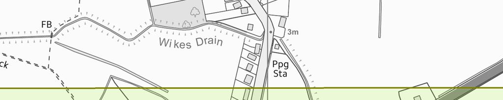
3 4.2 Health the CCG s have commented that currently there is some capacity at the local GP surgery(ies) to accommodate additional patients, however County-wide there is an increasing shortage of GP s, nurses and other healthcare staff which could affect future capacity should demand increase. 4.3 Flood risk the Environment Agency has commented that all the sites in Flood Zone 3a would need to satisfy the NPPF Exceptions Test. 4.4 Anglian Water has commented that the capacity of the surface water network has major constraints, and that all developments should seek to reduce flood risk and incorporate Sustainable Drainage Systems (SuDS). They indicate that surface water may not be discharged to the public foul sewerage network, and that no new surface water flow will be permitted to discharge to the combined network. 4.5 Sewage Treatment The Environment Agency has commented that the Donington Water Recycling Centre (Sewage Treatment Works) has capacity for 653 houses. Anglian Water has commented that the Water Recycling Centre can accommodate all sites except Don006, Don017 and Don033, without an upgrade being required, and that the foul sewerage network would require upgrading for all sites except Don012, Don030 and Don031. Enhancements to the capacity of the network may be necessary to accommodate the development of the other sites. 4.6 Water Supply Anglian Water has commented that water resources are adequate to serve the proposed growth. The supply network would require upgrading for all sites.
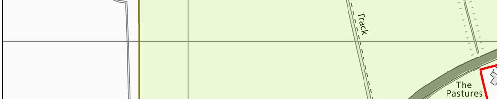
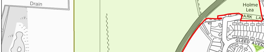
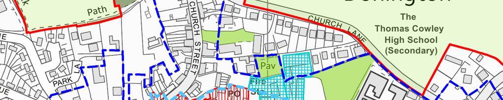
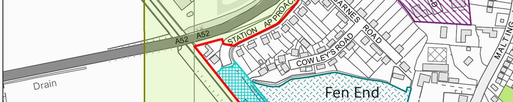
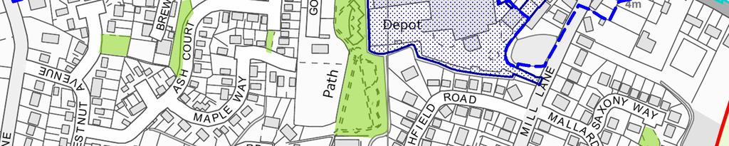
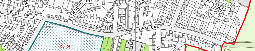
4 5 DONINGTON SITE OPTIONS 5.1 Inset Map 4 of the South East Lincolnshire Local Plan Draft for Public Consultation (January 2016) identified twelve Potential Housing Sites, Don001, Don006, Don008, Don012, Don016, Don017, Don018, Don029, Don030, Don031, Don032 and Don Comments received - The following comments were made on site Don001 (Land to the south of Town Dam Lane, Donington): 1. support Don001 because it is close to schools and a children s play area; 2. this site together with those on Malting Lane could be developed without appearing to stretch the town's development area. 5.3 Responses to the above comments: 1. support for the potential housing site is noted; the site is within 100m of a children s play area and primary school; and 2. the site is adjacent to the settlement boundary and the SHLAA identifies that the site will not have adverse impacts on natural, built or historic assets; nor upon the character and appearance of the area as it is surrounded by development and therefore does not have a countryside character. 5.4 Conclusions on site Don001 It is considered that site Don001 is one of the most suitable Potential Housing Sites in Donington, and that it should be taken forward as a Preferred Housing Site: the Sustainability Appraisal scores site Don001 reasonably well with three positive (green) impacts/13 being recorded relating to housing delivery, inclusive communities and landscape character; the site is within Flood Zone 2, flood hazard in 2115 is classified as no hazard, and flood depth in 2115 is classified as no hazard not one of the most, but not one of the least sequentially preferable sites in Donington; the Highways Authority identifies that services and facilities are potentially accessible on foot and bicycle. There are two road frontages that are sufficiently open to provide the required visibility for the access to the site although frontage footpaths, kerbs and drainage are required and a watercourse may need to be culverted or piped, it appears a satisfactory access could be achieved although this might be more straightforward in conjunction with the adjoining Don006;
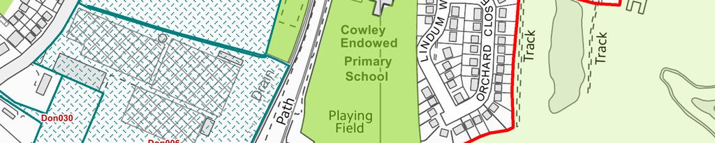
5 development of site Don001 in conjunction with the adjoining Don006 and Don030 should enable a better form of design and development to be achieved, including provision of infrastructure needed to serve the development; the SHLAA identifies that there is a reasonable prospect that it would be developed (assumed to begin in year 9, and be completed before year 15) [the plan is currently in year 6], so this site is considered to be deliverable, therefore able to contribute to the Council s five year supply of available housing sites; and no objections to the site s allocation were made. 5.5 Comments received - The following comments were made on site Don006 (Land to the east of Town Dam Lane, Donington): 1. support for this as a potential housing site; 2. the site is available now with developer interest for 100 units, open space and children s play area so should be re-classified as available within years 6-10 years, as a planning application will be submitted within the next six months; 3. support Don006 because it is within easy walking and cycling distance of schools, shops, bus stops, play area and community facilities; 4. the site is in low flood risk area; 5. the SHLAA suggests there is some filled land on the site, which is incorrect; 6. this site together with those on Malting Lane could be developed without appearing to stretch the town's development area. 5.6 Responses to the above comments: 1. support for the potential housing site is noted; 2. confirmation of the site s availability is welcome, and the developer interest is noted the SHLAA identifies the site as being deliverable from years 6-10 which reflects the owners intentions; 3. the site has good walking/cycling access to a range of local services and is within 350m of open space, children s play area, playing fields, primary school and community centre and 1km of the town centre; 4. the site is within Flood Zone 2, flood hazard in 2115 is classified as no hazard, and flood depth in 2115 is classified as no hazard, not the most sequentially preferable site in Donington, but not the least; 5. reference in the SHLAA to the contaminated land register is incorrect; SHDC Environmental Health identify that the site is on a list of potentially contaminated sites requiring further investigation ;
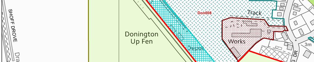
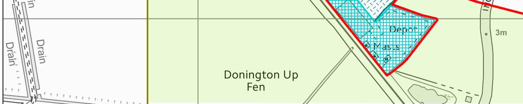
6 6. development of site Don006 in conjunction with the adjoining Don001 and Don030 should enable a better form of design and development to be achieved, including provision of infrastructure needed to serve the development; 7. the SHLAA identifies that the site will change the character and appearance of the area from the south as it will extend development further than the current glasshouses (although impacts can be reduced by site layout, design, landscaping and the use of green infrastructure). 5.7 Conclusions on site Don006 It is considered that site Don006 is one of the most suitable Potential Housing Sites in Donington, and that it should be taken forward as a Preferred Housing Site: the Sustainability Appraisal scores site Don006 as having one positive (green) impact/13 relating to housing delivery but a further eight (blue) impacts could deliver positive impacts as a result of a high quality design and the delivery of infrastructure to meet the needs of future residents such as open space and school places; the Highways Authority identifies that services and facilities are potentially accessible on foot and bicycle. A frontage footway, kerbs and drainage would be required and need to extend northwards if Don001 does not come forward first. The frontage would provide suitable junction visibility. Therefore it appears that a satisfactory, straightforward access solution can be achieved; the SHLAA identifies that there is a reasonable prospect that it would be developed (assumed to begin in year 9, and be completed before year 15) [the plan is currently in year 6], so this site is considered to be deliverable, therefore able to contribute to the Council s five year supply of available housing sites; and no objections to the site s allocation were made. 5.8 Comments received - The following comments were made on site Don008 (Land to the west of Malting Lane, Donington): 1. this site is available, with developer interest; a planning application for 73 dwellings is being prepared; 2. the site will be deliverable within years 6-10 rather than years 11-15; 3. the site can enhance existing infrastructure; high quality public open space, children's play area and provision of 30% affordable housing could all be provided; 4. a Phase 1 Habitat Survey confirms that only the existing ditches on the north and south west boundaries have biodiversity value. These will be retained with suitable buffer zones. Great Crested Newt and Water Vole Surveys have been undertaken - none were observed. A wildlife pond
7 in the Sustainable Drainage System will enhance the site s biodiversity value; 5. the site is bounded on two sides by housing, a new residential development and Turners (Soham) Haulage Business. This site is a logical location for a residential development/small urban extension. 5.9 Responses to the above comments: 1. confirmation of the site s availability is welcome, a planning application for approximately 73 dwellings is pending; 2. the SHLAA identifies the site as being deliverable from years 6-10 which reflects the owners intentions; 3. the physical and community infrastructure proposed on site is noted; 4. the outcome of the Phase 1 Habitat Survey and Protected Species Surveys are noted and the biodiversity enhancements proposed are welcome; 5. the SHLAA identifies that the site will not change the built up character and appearance of the area Conclusions on site Don008 - It is considered that site Don008 is one of the more suitable Potential Housing Sites in Donington, and that it should be taken forward as a Preferred Housing Site: the Sustainability Appraisal scores site Don008 as having two/13 positive (green) impacts relating to housing delivery and landscape character but a further six (blue) impacts could deliver positive impacts as a result of a high quality design and the delivery of infrastructure to meet the needs of future residents such as open space and school places; the site is adjacent to the settlement boundary and is well-located for easy walking/cycling access to local shops and employment; the SHLAA recognises that the site is close to a distribution site which will impact on the residential amenities of this site (although impacts can be reduced by site layout, house design, bunding/screening and acoustic vents to bedrooms facing the site); the Highways Authority identifies that services and facilities are potentially accessible on foot and bicycle. The access would be close to the junction for the adjoining recently developed site but this is acceptable in this situation. It appears that a suitable, straightforward access solution can be achieved; the SHLAA identifies that there is a reasonable prospect that it would be developed (assumed to begin in year 9, and be completed before year 15) [the plan is currently in year 6], so this site is considered to be deliverable, therefore able to contribute to the Council s five year supply of available housing sites; and
8 no objections to the site s allocation were made Comments received - No comments were received relating to site Don012 (Land to the north of Park Lane, Donington) Conclusions on site Don012 - It is considered that site Don012 is not one of the more suitable Potential Housing Sites in Donington, and that it should not be taken forward as a Preferred Housing Site: the Sustainability Appraisal scores site Don012 with two/12 positive (green) impacts relating to housing delivery and flood risk, but three negative (orange) impacts have been recorded relating to access to community facilities, accessibility and air, water and soil quality; the Highway Authority identifies that services and facilities are potentially accessible on foot and bicycle. Park Lane would require widening and upgrading including a new footpath. Although it appears that a satisfactory vehicular access could be provided to this site, arrangements for other, alternative sites will be more straight-forward Comments received - The following comments were made on site Don016 (Land to the south of Town Dam Lane, Donington): 1. support development on Don016; 2. confirm availability of Don016; 5.14 Responses to the above comments: 1. support for site Don016 is noted; and 2. confirmation of availability is welcome Conclusions on site Don016 - It is considered that site Don016 is not one of the more suitable Potential Housing Sites in Donington, and that it should not be taken forward as a Preferred Housing Site: the Sustainability Appraisal scores site Don016 with two positive (green) impacts being recorded for housing delivery and landscape character but with two negative (orange) impacts relating to accessibility and soil, air and water quality; the site is detached from the settlement boundary, and does not relate as well as other sites to the Donington built area; the Highways Authority identifies that services and facilities are accessible on foot and bicycle. Residential development would be likely to increase traffic eastwards on Town Dam Lane (a single track road) towards Quadring Road. This would not be suitable without extensive
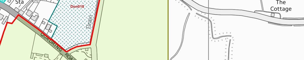
9 highways improvements. Although it appears that a satisfactory vehicular access could be provided to this site, arrangements for other, alternative sites will be more straight-forward; the site is within Flood Zone 3a, flood hazard in 2115 is classified as no hazard, and flood depth in 2115 is classified as no hazard, one of the least sequentially preferable sites in Donington; 5.16 Comments received - The following comments were made on site Don017 (Land to the north of Town Dam Lane, Donington): 1. support development on Don017; and 2. confirm availability of Don Responses to the above comments: 1. support for site Don017 is noted; 2. confirmation of availability is welcome; 5.18 Conclusions on site Don017 It is considered that site Don017 is not one of the more suitable Potential Housing Sites in Donington, and that it should not be taken forward as a Preferred Housing Site: the Sustainability Appraisal scores site Don017 with two positive (green) impacts being recorded for housing delivery and landscape character; the Highways Authority identifies that services and facilities are potentially accessible on foot and bicycle. This site has good visibility along the A152, which has street lighting and 30mph speed limit. Development would require a frontage footway to the existing network, extended street lighting and highway drainage. Access to Town Dam Lane would not be acceptable without extensive improvements. Although it appears that a satisfactory vehicular access could be provided to this site, arrangements for other, alternative sites will be more straight-forward; the SHLAA identifies that the site will change the character and appearance of the area as it will extend development to the highway, which will affect some other sites to a lesser extent Comments received - The following comments were made on site Don018 (Land to the north of Quadring Road, Donington): 1. support development on Don018; and 2. confirm availability of Don018.
10 5.20 Response to the above comments: 1. support for site Don018 is noted; 2. confirmation of availability is welcome; 5.21 Conclusions on site Don018 It is considered that site Don018 is one of the more suitable Potential Housing Sites in Donington, and that it should be taken forward as a Preferred Housing Site: the Sustainability Appraisal scores site Don018 as having three positive (green) impacts for housing delivery, landscape character and flood risk although a further seven (blue) impacts could deliver positive impacts as a result of a high quality design and the delivery of infrastructure to meet the needs of future residents such as open space and school places; the SHLAA identifies that the site will change the character and appearance of the area as it will extend development to the highway, however the extent of development will not be as great as for some other sites; the site is within Flood Zone 1, flood hazard in 2115 is classified as no hazard, and flood depth in 2115 is classified as no hazard, and is one of the most sequentially preferable sites in Donington; the Highways Authority identifies that services and facilities are potentially accessible on foot and bicycle. The site has sufficient frontage to the A152 to provide suitable junction visibility. There is an existing frontage footway. There is suitable access from Crosslands. Vehicular access from Wykes Lane (an unclassified road) to the east would not be acceptable. It appears that a satisfactory straightforward vehicular access could be provided to this site; and the SHLAA identifies that there is a reasonable prospect that it would be developed (assumed to begin in year 9, and be completed before year 15); [the plan is currently in year 6], so this site is considered to be deliverable, therefore able to contribute to the Council s five year supply of available housing sites; no objections to the site s allocation were made Comments received - The following comments were made on site Don029 (Land adjacent to 69 Quadring Road, Donington): 1. support for this as a potential housing site Response to the above comments: 1. the support for this potential housing site is noted.
11 5.24 Conclusions on site Don029 It is considered that site Don029 is not one of the more suitable Potential Housing Sites in Donington, and that it should not be taken forward as a Preferred Housing Site: the Sustainability Appraisal score site Don029 with two positive (green) impacts being recorded against housing delivery and flood risk and two negative (orange) impacts recorded against accessibility and soil, air and water quality; Site Don029 is detached from Donington settlement boundary, on its own this site would form an isolated, incongruous form of development in the countryside, and would generate more of an adverse impact on the landscape than other sites; the SHLAA identifies that the site is only appropriate alongside the Don017, which has been discounted (see above) Comments received - The following comments were made on site Don030 (Land to the east of Town Dam Lane, Donington): 1. the site is developable and deliverable, with developer interest; 2. the site is within easy walking and cycling distance of schools, local shops and services and community facilities; 3. the site is in low flood risk area; 4. the SHLAA suggests there is some filled land on the site, which is incorrect; 5. this site together with those on Malting Lane could be developed without appearing to stretch the town's development area Response to the above comments: 1. confirmation of the site s availability is welcome, and the developer interest is noted; 2. the site has good walking/cycling access to a range of local services being within 750m of open space, children s play area, playing fields, primary school and community centre and 1km of the town centre; 3. the site is within Flood Zone 2, flood hazard in 2115 is classified as no hazard, and flood depth in 2115 is classified as no hazard, so not the most sequentially preferable site in Donington, but not the least either; 4. reference in the SHLAA to the contaminated land register is incorrect; SHDC Environmental Health identify that the site is on a list of potentially contaminated sites requiring further investigation ; and 5. the SHLAA identifies that the site will change the character and appearance of the area from the south as it will extend development further than the current glasshouses (although impacts can be reduced by site layout, design, landscaping and the use of green infrastructure).
12 5.27 Conclusions on site Don030 It is considered that site Don030 is one of the more suitable Potential Housing Sites in Donington, and that it should be taken forward as a Preferred Housing Site: the Sustainability Appraisal scores site Don030 as having one positive (green) impact being recorded for housing delivery, but a further seven (blue) impacts could deliver positive impacts as a result of the delivery of the site which could secure meaningful infrastructure to meet the needs of future residents such as access to employment and education facilities; and development of site Don030 in conjunction with the adjoining Don001 and Don006 should enable a better form of design and development to be achieved, including provision of infrastructure needed to serve the development; the Highways Authority identifies that there maybe enough land to form new junction radii and visibility splays. The carriageway is suitable but there would need to be footway to the existing network. So it appears that a satisfactory, straightforward access solution could be achieved; the SHLAA identifies that there is a reasonable prospect that it would be developed (assumed to begin in year 7, and be completed before year 10); [the plan is currently in year 6], so this site is considered to be deliverable, therefore able to contribute to the Council s five year supply of available housing sites; no objections to the site s allocation were made Comments received No comments were received relating to site Don031 (Land to the north-east of Quadring Road, Donington) Conclusions on site Don031 It is considered that site Don031 is not one of the more suitable Potential Housing Sites in Donington, and that it should not be taken forward as a Preferred Housing Site: the Sustainability Appraisal identifies Don031 as having one positive (green) impact for housing delivery; Site Don031 is detached from Donington settlement boundary, so other sites would have better access to local shops, services and facilities; the site would create an isolated group of dwellings in the countryside having more of an adverse impact on the landscape than other sites; the site is within Flood Zone 3a, flood hazard in 2115 is classified as no hazard, and flood depth in 2115 is classified as no hazard, one of the least sequentially preferable sites in Donington.
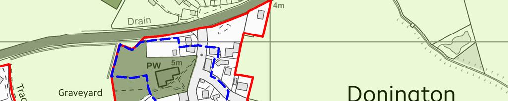
13 5.30 Comments received - The following comments were made on site Don032 (Land to the north-east of Park Lane, Donington): 1. support for housing development on Site Don032 because it would make good use of the site; 2. the site is located close to the village centre, has good transport links and its housing will support local services; 3. Site Don032 is the only surviving open space adjacent to the Church of St Mary and the Holy Rood, and the graveyard and would adversely harm this Grade I Listed Building and its setting Response to the above comments: 1. support for this potential housing site is noted; 2. the site is within 280m of the town centre and is within 1km of local schools, open space and bus stops; 3. the Grade I Listed Church of St Mary and the Holy Rood are important designated heritage assets forming an integral part of the character and appearance of Donington and its Conservation Area. Historic England consider that the development of Don032 could harm these assets and their setting; adverse impacts are unable to be prevented by design; 5.32 Conclusions on site Don032 It is considered that site Don032 is not one of the more suitable Potential Housing Sites in Donington, and that it should not be taken forward as a Preferred Housing Site: the Sustainability Appraisal scores site Don032 as having one positive (green) impact for housing delivery and identifies three negative (orange) impacts relating to accessibility, heritage and soil, air and water quality; the impact on designated heritage assets is an issue which does not affect alternative sites Comments received - The following comments were made on site Don033 (Land to the north of Church Lane, Donington): 1. the owner states that the site is available and deliverable for residential development and has developer interest; 2. the site is able to deliver a planned (possibly phased) housing development with wider public benefits, such as a mix of homes, open space and possibly wider public benefits such as a school drop off area which could not be delivered on other sites in Donington; 3. the land has the lowest flood risk;
14 4. the site has two vehicular access points (Church Lane & Browntoft Lane), would necessitate no new access point off the A52 and would not necessitate traffic to use Station Street to access the A52; 5. the site is within a highly sustainable location, within walking distance of local shops, services and schools; 6. the site should be identified as expansion land for the secondary school; a new sports hall could be built there so the existing hall can be redeveloped into classrooms. Being on a separate site would mean it could be used out of hours by residents; 7. Don033 partially adjoins Donington Conservation Area. Further assessment is required to determine the impact on the significance of these heritage assets Response to the above comments: 1. confirmation of availability and deliverability is welcome; 2. the mix of houses, the proposed phasing and the physical and community infrastructure proposed for the site is noted; 3. the site is within Flood Zone 1, flood hazard in 2115 is classified as no hazard, and flood depth in 2115 is classified as no hazard one of the most sequentially preferable sites in Donington; 4. the Highways Authority identifies that services and facilities are potentially accessible on foot and bicycle. The carriageways of Church Lane and Browntree lane are suitable to serve residential development but frontage footways and connections to the existing footpath network, together with kerbs and drainage are required. It appears that a satisfactory, straightforward vehicular access could be provided to this site; 5. the site is within 350m of the town centre, a secondary school and other local facilities; 6. the County Education Authority comment that there are no plans to expand the secondary school; 7. the site abuts the Donington Conservation Area for 110m and, with careful layout, design and choice of materials it is considered that impacts are highly likely to be acceptable Conclusions on site Don033 It is considered that site Don033 is not one of the more suitable Potential Housing Sites in Donington, and that it should not be taken forward as a Preferred Housing Site: the Sustainability Appraisal scores site Don033 as having two/13 positive (green) impacts for delivering inclusive communities and flood risk, and two negative (orange) impacts relating to accessibility and soil, air and water quality; the scale of housing growth proposed for Donington took account of many issues, including: the findings of the South East Lincolnshire
15 6 NEW SITES Assessment of Settlements & their Sustainability Credentials (June 2015); the population of the parish; the local rate of housing growth between 1976 and 2011; and the local availability of land at lower risk of flooding. This site has the capacity to provide for 203 dwellings at 20 dwellings to the hectare, (whereas the reality is that most sites will be developed at a higher density), which if taken with other appropriate sites would exceed the housing requirement for Donington, which based on the evidence available is not sustainable. 6.1 The following new site was put forward for consideration as Potential Housing Sites: 1. Don034 - Land to the east of Northorpe Road, Donington. The Strategic Housing Land Availability Assessment (SHLAA) identifies this site as undevelopable because it is detached from the Donington built area by the A52, with more limited access to it shops and services, than other sites to the south of the A52. 7 PREFERRED OPTIONS HOUSING ALLOCATIONS AND TRAJECTORY 7.1 The following sites are taken forward as Preferred Options Housing Allocations: Don001; Don006; Don008; Don018 and Don030. These five sites have a combined capacity of 299 dwellings, which is slightly higher than the residual requirement of 295 dwellings. However, these sites would enable a more appropriate form of development to be achieved overall. 7.2 These allocations and other development opportunities provide the following trajectory for Donington. [The capacity of the sites assumes that they will be developed at a density of 20 dwellings to the hectare. In practice, some sites are likely to accommodate a higher density.] Years Years Years Years Years Years TOTAL Completions Commitments Don Don Don Don Don TOTAL


16
Welcome. Site/11/04. Site/11/03. Proposed Site. 11,400 new homes needed in east Cambs
 Welcome Welcome to our consultation on our proposals for new homes on land north east of Soham Road, Fordham. Members of the project team are available to answer any questions you have and listen to feedback.
Welcome to our exhibition
 Welcome to our exhibition The Homes & Communities Agency (HCA) welcomes you to this public exhibition explaining our proposals for the redevelopment of the former Lea Castle Hospital site. About the Homes
DUNSFOLD NEIGHBOURHOOD PLAN Site Selection Policies
 DUNSFOLD NEIGHBOURHOOD PLAN Site Selection Policies The criteria for assessing sites for future housing and business development in Dunsfold are set out below. (Development criteria, covering what it is
Development of land adjacent to Braggs Farm Lane and Rumbush Lane, Dickens Heath. Welcome. Today s exhibition. The proposal site
 Welcome Welcome to this event to discuss the development of land adjacent to Braggs Farm Lane. is currently in the preliminary stages of designing proposals to sensitively develop this site with high-quality
WELCOME GYPSY LANE. Wider Site Location plan. Proposals for the development of LAND OFF FOXLYDIATE LANE WEBHEATH. Proposals for the development of
 WELCOME The developers are preparing an outline planning application for a residential led development and need the community s views in order to develop the proposals further WHAT IS PROPOSED? A high
Land at Fiddington Hill Nursery, Market Lavington
 Land at Fiddington Hill Nursery, Market Lavington Briefing Report for Market Lavington Parish Council Persimmon Homes (Wessex) April 2016 Background This brief report has been prepared following the Market
Rochford District Council Allocations Development Plan Document: Discussion and Consultation Document Sustainability Appraisal
 Option SWH1 Balanced Communities Option SWH1 1 To ensure the delivery of high quality sustainable communities where people want to live and work Will it ensure the phasing of infrastructure, including
Site Assessment Technical Document Appendix A: Glossary
 Central Bedfordshire Council www.centralbedfordshire.gov.uk Site Assessment Technical Document Appendix A: Glossary July 2017 1.1.11-1 - ii Appendix A: Glossary Term Agricultural Land Classification AONB
Carterton Construction Ltd is bringing forward plans for up to 85 new family homes and extra care facilities on land east of Burford.
 Welcome Carterton Construction Ltd is bringing forward plans for up to 85 new family homes and extra care facilities on land east of. We are at the early stages of designing our proposals and have a number
Key Principles. 290 Phasing Principles and Programme
 4 Phasing principles and programme 4c The aims of the phasing strategy are to satisfy planning policy requirements and create a sustainable, strong and healthy new community where, from the outset, people
3. Neighbourhood Plans and Strategic Environmental Assessment
 1. Introduction This report sets out a draft Screening Determination for the Preston Parish Council s Neighbourhood Plan and has been prepared by rth Hertfordshire District Council. The purpose of the
Committee Report. Case Officer: Gemma Walker. Ward: Bacton & Old Newton. Ward Member/s: Cllr Jill Wilshaw.
 Committee Report Item No: 1 Ward: Bacton & Old Newton. Ward Member/s: Cllr Jill Wilshaw. Reference: DC/17/05423 Case Officer: Gemma Walker Description of Development Outline planning application (all matters
Neighbourhood Planning Site Assessment Pro-forma and Guide Version 2
 Neighbourhood Planning Site Assessment Pro-forma and Guide Version 2 September 2014 Site HNP 006 Land East of Stanbridge Road and North of Lower Road 1. Background information Site location and use Site
Site ref: AS06 Site Name or Address: Murreys Court, Agates Lane
 Site ref: AS06 Site Name or Address: Murreys Court, Agates Lane Proposed Land Use: Total Site Area (Ha): Housing 1.85 Ha Description: It is understood that the owner has no plans to dispose of the site
SITE ASSESSMENT CHECKLIST
 1. Site Details a. What is the site s name/reference? SITE ASSESSMENT CHECKLIST CR3NPWHY 3007 Gasometer Site Godstone Road CR3 0EG b. Where is the site located? Wyhteleafe; Godstone Road. Urban category1
Plumpton Neighbourhood Plan Site Assessment Report
 Plumpton Neighbourhood Plan Site Assessment Report May 2016 1 Contents 1. Introduction 3 2. Methodology 4 2.1 Identification of Potential Sites 4 2.2 Assessment Process 5 2.3 Assessment Criteria 6 2.4
Neighbourhood Plan Representation
 Date: 10 th November 2017 Neighbourhood Plan Representation Land to the east of Callow Hill Road, Alvechurch Introduction This representation has been prepared by RPS Planning and Development on behalf
Plumpton Neighbourhood Development Plan Revised Pre Submission Document - Regulation 14 Consultation
 REPRESENTATIONS... Plumpton Parish Council Plumpton Neighbourhood Development Plan Revised Pre Submission Document - Regulation 14 Consultation Representations submitted on behalf of: Cala Homes (South
WELCOME. Land North of STEVENAGE. We would like to thank you for attending our public exhibition today.
 WELCOME We would like to thank you for attending our public exhibition today. The purpose of this event is to share our proposals and hear your thoughts on our ideas. Members of the project team are on
Welcome to our public consultation
 About our development Welcome to our public consultation This exhibition gives you the chance to view and comment on our proposals for a residential development of up to 187 high-quality homes, along with
Public Consultation. Land at Monks Farm, North Grove. Welcome
 Welcome Welcome to our public exhibition for development on Land at Monks Farm, orth Grove. Gallagher Estates and Gleeson Strategic Land are preparing an outline planning application for new homes, open
Ashtead Neighbourhood Forum Site Assessment AS07 Old Chalk Pit, Pleasure Pit Road. Site ref: AS07 Site address: Old Chalk Pit, Pleasure Pit Road
 Site ref: AS07 Site address: Old Chalk Pit, Pleasure Pit Road Proposed Land Use: Total Site Area (Ha): Housing 0.7ha Description: The site was formally an old chalk pit that has been partially filled and
Newcourt Masterplan. November Exeter Local Development Framework
 Newcourt Masterplan November 2010 Exeter Local Development Framework Background The Exeter Core Strategy Proposed Submission sets out the vision, objectives and strategy for the development of Exeter up
Land at Rampton Road. Cottenham
 Land at Rampton Road Cottenham Introduction TEP is preparing an outline planning application for 54 dwellings on 6.9 hectares of land adjacent to Rampton Road, Cottenham on behalf of the owners Cambridgeshire
WELCOME. Welcome and thank you for visiting today.
 WELCOME Welcome and thank you for visiting today. Bellway Homes Ltd (Yorkshire) are preparing a reserved matters planning application for a residential development of 293 homes at land North of Yew Tree
Statement of Community Involvement LAND OFF SOUTHDOWN ROAD HORNDEAN, HAMPSHIRE
 LAND OFF SOUTHDOWN ROAD HORNDEAN, HAMPSHIRE CONTENTS Page 1. Introduction 3 2. Pre-application Discussions 4 3. The Consultation Process 5 4. Consultation Feedback 7 5. Responses to Consultation Feedback
Everton s Neighbourhood Plan. Site Allocation - Assessment Criteria
 Everton s Neighbourhood Plan Site llocation - ssessment Criteria Introduction 1.1 This report assesses all the sites identified through the emerging Neighbourhood Plan for Everton and their potential for
Welcome. Land adjacent Sandy Lane WALTHAM CHASE THE PROPOSED SITE
 Land adjacent Sandy Lane WALTHAM CHASE Existing Linden Homes developments Welcome Welcome to Linden Homes Southern s ( Linden ) public exhibition about its proposals for a range of high-quality homes for
Settlement Boundaries Methodology North Northumberland Coast Neighbourhood Plan (August 2016)
") Introduction This background paper sets out a methodology for the definition of settlement boundaries in the North Northumberland Coast Neighbourhood Plan. The neighbourhood plan is planning positively
Introduction This background paper sets out a methodology for the definition of settlement boundaries in the North Northumberland Coast Neighbourhood Plan. The neighbourhood plan is planning positively
Story Homes. Land at Thirsk Road, Kirklevington. An Introduction to Story Homes. Our Foundations. Commitment to Consultation.
 Story Homes An Introduction to Story Homes Founded by Fred Story in 1987, Story Homes has a long and successful reputation of building high quality and high specification homes. The family owned business
Welcome to our public exhibition
 About our development Welcome to our public exhibition This exhibition gives you the chance to view and comment on our proposals for a new residential development of 165 high-quality homes, along with
Welcome to our public exhibition
 About Our Scheme Welcome to our public exhibition This exhibition gives you the chance to view and comment upon our emerging proposals for a new residential development of 68 new homes on the site of the
Welcome to our Public Consultation
 About our development This exhibition gives you the chance to view and comment on our emerging plans for a proposed residential development located on land to the West of Alwyn Road, Rugby. Welcome to
1. Local Plan Context
 1. Local Plan Context WHY ARE YOU HERE? ABOUT US PLANNING APPLICATION CONSULTATION Stewart Milne Homes are in the process of preparing a detailed planning application for a development of approximately
CAERNARFON DEPENDENCY CATCHMENT AREA
 CAERNARFON DEPENDENCY CATCHMENT AREA GWYNEDD UNITARY DEVELOPMENT PLAN - HOUSING Map not to scale Dependency Catchment Area Location 2 Caernarfon Topic Housing To the rear of Bro Eglwys, Bethel. Grid Ref.
Copyright Nigel Deeley and licensed for reuse under this Creative Commons Licence
 1 Copyright Nigel Deeley and licensed for reuse under this Creative Commons Licence Prepared by the Neighbourhood Plan Steering Group on behalf of Garway Parish Council with assistance from 2 Table of
26 September 2014 CONSULTATION EXPIRY : APPLICATION EXPIRY : 22 July 2014 SUMMARY RECOMMENDATION: PERMISSION
 Item No.: 5 The information, recommendations and advice contained in this report are correct as at the date of preparation, which is more than one week in advance of the Committee meeting. Because of the
About 10% of the Borough's population lives in the seven rural parishes. Population figures from the 1991 census are given below:-
 8. THE DISTRICT VILLAGES 8.1 Population About 10% of the Borough's population lives in the seven rural parishes. Population figures from the 1991 census are given below:- Village No. of Persons Cottingham
Bradleys Both Parish Council
 Bradleys Both Parish Council Bradleys Both Housing Site Assessments April 2015 Contents 1.0 Introduction... 2 2.0 BR001 Health Lea and Land to Rear, Skipton Road... 2 3.0 BR002 Holly Tree House and Land
SITE ASSESSMENT CHECKLIST
 1. Site Details a. What is the site s name/reference? CR3 FORUM NEIGHBOURHOOD PLAN SITE ASSESSMENT CHECKLIST CR3NPCOH3016 Douglas Brunton Centre Park Rd b. Where is the site located? Caterham Hill urban
LONGDEN VILLAGE DEVELOPMENT STATEMENT
 LONGDEN VILLAGE DEVELOPMENT STATEMENT 2017-2027 1 Longden Development Statement 2017-2027 15/01/18 1. Background 1.1 Longden Village Longden village is a very rural and traditional community first mentioned
DEVELOPMENT MANAGEMENT REPORT
 ITEM A07-1 DEVELOPMENT MANAGEMENT REPORT TO: BY: Development Management Committee (South) Development Manager DATE: 21 June 2016 DEVELOPMENT: SITE: WARD: APPLICATION: APPLICANT: Outline application for
Sustainability Statement. Whitby Business Park Area Action Plan
 Sustainability Statement Whitby Business Park Area Action Plan November 2014 Contents Page 1. Introduction 1 2. Scoping 3 3. Sustainability Appraisal of Options 6 4. Assessment of Draft Area Action Plan
INTRODUCTION. Land south of Bishopswood Lane, Tadley
 0 INTRODUCTION THE SITE Introduction Gladman Developments Ltd. has successfully invested in communities throughout the UK over the past 0 years, developing high quality and sustainable residential, commercial
CALA Homes is preparing a planning application for a development of up to 36 new homes, including a mix of properties to meet local demand.
 WELCOME Welcome to this public consultation event for our proposed development on land to the south of Twelve Leys in Wingrave. Thank you for taking the time to come along today. Homes is preparing a planning
EFDC Draft Local Plan Consultation Theydon Bois Guidance Notes Extended Version
 EFDC Draft Local Plan Consultation Theydon Bois Guidance Notes Extended Version There are nine questions you can respond to in the consultation if you wish. Epping Forest District Council (EFDC) has a
PART 2 SOUTH DOWNS NATIONAL PARK AUTHORITY SECTION 1 SCHEDULE OF APPLICATION RECOMMENDATIONS
 42 PART 2 SOUTH DOWNS NATIONAL PARK AUTHORITY PLANNING COMMITTEE REPORT OF THE SERVICE MANAGER PLANNING DEVELOPMENT Applications to be determined by the council on behalf of the South Downs National Park
Mortimer NDP, Principles, Vision and Policies
 The Three Principles Mortimer NDP, Principles, Vision and Policies 1. The NDP must make it possible for people to live the whole of their lives in the parish if they so wish 2. 2. The NDP will ensure that
SAHAM TONEY NEIGHBOURHOOD DEVELOPMENT PLAN : THE POLICIES
 SAHAM TONEY NEIGHBOURHOOD DEVELOPMENT PLAN 2018-2036: THE POLICIES This is a much-abridged version of the full neighbourhood Plan, and includes only the policy text, the main policy maps and some key charts.
Briefing Document of CNP. June 2017
 Cholsey Parish Council Cholsey Neighbourhood Plan Briefing Document of CNP June 2017 Cholsey Neighbourhood Plan Page! 1 of! 8 Cholsey Plan Briefing v1.4 Page Left Intentionally Blank Cholsey Neighbourhood
INTRODUCTION NORTH HEYBRIDGE GARDEN SUBURB
 INTRODUCTION This event is being hosted by the promoters of the proposed North Heybridge Garden Suburb who are working with Maldon District Council and other key stakeholders on the preparation of a comprehensive
EXTRACT FROM THE CUDDINGTON NEIGHBOURHOOD PLAN The Policies
 EXTRACT FROM THE CUDDINGTON NEIGHBOURHOOD PLAN The Policies Environment and Landscape Policy 1 - Landscape Setting Development should respect and wherever possible enhance the landscape setting of Cuddington
Parish of Repton NEIGHBOURHOOD DEVELOPMENT PLAN
 Parish of Repton NEIGHBOURHOOD DEVELOPMENT PLAN BASIC CONDITIONS STATEMENT December 2018 CEF 4 Legal Requirements This statement has been produced by the NDP Working Group on behalf of Repton Parish Council
Welcome to our public exhibition
 About our scheme Welcome to our public exhibition Taylor Wimpey East Anglia intends to submit a detailed planning application for a new residential development of 39 high-quality homes at the B&M Concrete
Ashtead Neighbourhood Forum Site Assessment AS03 Lime Tree Lodge, Farm Lane. Site address: Lime Tree Lodge, Farm Lane. Proposed Land Use:
 Site ref: AS03 Site address: Lime Tree Lodge, Farm Lane Proposed Land Use: Total Site Area (Ha): Housing 1.25ha Description The site is located off Farm Lane at the junction with Park Lane. To the north
Application Recommended for Approval Hapton with Park Ward
 Application Recommended for Approval Hapton with Park Ward APP/2017/0036 Outline Planning Application Outline application for the construction of a new 3 bedroom dwelling (with all matters reserved for
OKEFORD FITZPAINE NEIGHBOURHOOD PLAN
 OKEFORD FITZPAINE NEIGHBOURHOOD PLAN Dear Parishioner, The Neighbourhood Plan Project Team have prepared this leaflet to summarise the full Neighbourhood Plan document. It provides a summary of the Vision,
Ward: Southbourne. Outline application with all matters reserved. Erection of 5 no. dwellings and associated works.
 Parish: Southbourne Ward: Southbourne SB/16/00205/OUT Proposal Site Outline application with all matters reserved. Erection of 5 no. dwellings and associated works. Dunkirk South Lane Southbourne Emsworth
SOUTH CAMBRIDGESHIRE DISTRICT COUNCIL. REPORT TO: Planning Committee 7 October 2015 Planning and New Communities Director
 SOUTH CAMBRIDGESHIRE DISTRICT COUNCIL REPORT TO: Planning Committee 7 October 2015 AUTHOR/S: Planning and New Communities Director Application Number: Parish: Proposal: Site address: Applicant(s): Recommendation:
WELCOME. North East Haverhill. The Planning Process
 WELCOME North East The site to the North East of, known as Great Wilsey Park, is identified by St Edmundsbury Borough Council in its Core Strategy as capable of delivering a Sustainable Urban Extension.
Proposed Sheffield City Region Combined Green Belt Review A Common Approach August 2014
 Proposed Sheffield City Region Combined Green Belt Review A Common Approach August 2014 1.1 Purpose To achieve the principles of Duty to Cooperate, it is beneficial for all Local Authorities within the
LAND EAST OF MILL LANE, SHERBURN VILLAGE PLANNING STATEMENT
 LAND EAST OF MILL LANE, SHERBURN VILLAGE PLANNING STATEMENT On behalf of The Church Commissioners for England Land East of Mill Lane, Sherburn Village Planning Statement On Behalf of The Church Commissioners
an Inspector appointed by the Secretary of State for Communities and Local Government
 Appeal Decision Site visit made on 14 July 2015 by I Radcliffe BSc(Hons) MCIEH DMS an Inspector appointed by the Secretary of State for Communities and Local Government Decision date: 18 August 2015 Appeal
Construction of 9 dwellings and associated infrastructure.
 Application Number 16/00653/FUL Proposal Site Applicant Recommendation Construction of 9 dwellings and associated infrastructure. Land at Grange Road South, Hyde McDermott Developments Ltd Approve REPORT
Introduction. Welcome to this consultation regarding the draft redevelopment proposals for the former CeramTec factory on Sidmouth Road, Colyton.
 Introduction Welcome to this consultation regarding the draft redevelopment proposals for the former CeramTec factory on Sidmouth Road, Colyton. We are currently considering options for the mixed-use redevelopment
Form to Submit Land for Residential Evidence Gathering Shepway Strategic Housing Land Availability Assessment (SHLAA) Partial Review
 Partial Review") Form to Submit Land for Residential Evidence Gathering Shepway Strategic Housing Land Availability Assessment (SHLAA) Partial Review All organisations and individuals who wish to put forward land for consideration
Form to Submit Land for Residential Evidence Gathering Shepway Strategic Housing Land Availability Assessment (SHLAA) Partial Review All organisations and individuals who wish to put forward land for consideration
Schedule of Planning Applications Committee Date: 23 May Reference: 06/17/0726/F Parish: Hemsby Officer: Mr J Beck Expiry Date:
 Schedule of Planning Applications Committee Date: 23 May 2018 Reference: 06/17/0726/F Parish: Hemsby Officer: Mr J Beck Expiry Date: 22-05-2018 Applicant: Proposal: Site: Mr Gillett Change of use to the
DEVELOPMENT MANAGEMENT REPORT
 ITEM A08-1 DEVELOPMENT MANAGEMENT REPORT TO: BY: DATE: DEVELOPMENT: SITE: WARD: APPLICATION: APPLICANT: Development Management Committee Development Manager Proposed live/work unit in connection with existing
Chapter 2: OUTLINE PLANNING APPLICATION PROPOSALS. A New Garden Neighbourhood Matford Barton 17
 Chapter 2: OUTLINE PLANNING APPLICATION PROPOSALS A New Garden Neighbourhood Matford Barton 17 2.1. SUMMARY AND STATUS OF THE PROPOSALS 2.1.1. The parameter plans and associated wording in this chapter
7.1.6 The main components of the development strategy for Hertford are as follows:
 Chapter 7 Hertford 2 Chapter 7 Hertford 7.1 Introduction 7.1.1 The County town of Hertford lies at the confluence of four rivers in a valley setting, which in the past has influenced its shape and form.
8.0 Design and Form of Development 43/
 42/ 8.0 Design and Form of Development 43/ Rothwells Farm, Golborne/ Development Statement Figure 7. Site Constraints Key 44/ Site Boundary 360 Bus Route/Stops Existing Trees Underground Water Pipe Sensitive
Sutton cum Lound Neighbourhood Plan
 Sutton cum Lound Parish Neighbourhood Plan 2016-2031 Pre-Submission Consultation Version Sutton cum Lound Neighbourhood Plan 2016-2031 Sutton cum Lound Neighbourhood Plan Steering Group on behalf of Sutton
Kibworth Harcourt. Introduction. Introduction
 Introduction Introduction Welcome to this public exhibition on the proposals for the delivery of new homes on land at The Kibworths. The purpose of today s exhibition is to give you the opportunity to
WHITELEY TOWN COUNCIL NORTH WHITELEY DEVELOPMENT SEPTEMBER 2014
 WHITELEY TOWN COUNCIL NORTH WHITELEY DEVELOPMENT SEPTEMBER 2014 Dear Resident This Special Edition of the Whiteley Voice which has been prepared in conjunction with the North Whiteley Consortium is to
SITE ASSESSMENTS. September 2018 SOUTHWATER PARISH COUNCIL BEESON HOUSE, 26 LINTOT SQUARE, SOUTHWATER, RH13 9LA
 September 2018 SITE ASSESSMENTS PREPARED TO ASSIST THE PREPERATION OF THE SOUTHWATER NEIGHBOURHOOD PLAN SOUTHWATER PARISH COUNCIL BEESON HOUSE, 26 LINTOT SQUARE, SOUTHWATER, RH13 9LA INTRODUCTION TABLE
WELCOME LAND EAST OF TYE LANE, WALBERTON. Above all, it s about people
 WELCOME Welcome to this public exhibition relating to our draft residential proposals for the land east of Tye Lane, Walberton. Today gives you the opportunity to have an active role in shaping these ideas
Great Easton Neighbourhood Plan Statement of Basic Conditions
 Great Easton Neighbourhood Plan 2017-2031 Statement of Basic Conditions OCTOBER 2016 GREAT EASTON PARISH COUNCIL Contents 1.0 Introduction....Page 2 2.0 Summary of Submission Documents and Supporting Evidence..
ABOUT CALA HOMES CALA HOMES
 WELCOME Welcome to this public consultation event for our proposed development on land to the east of Salisbury Road, in Hungerford. Thank you for taking the time to come along today. Homes and Wates Developments
The Place Solar Farm
 The Place Solar Farm Environmental Statement Non-Technical Summary 28 August 2014 Produced for Prepared by St John s House Queen Street, Manchester M2 5JB Contents Contents... 2 1 Introduction... 3 1.1
WINCHESTER TOWN 3.1 LOCATION, CHARACTERISTICS & SETTING
 WINCHESTER TOWN 3.1 LOCATION, CHARACTERISTICS & SETTING 3.1.1 The area referred to by the City Council, as Winchester Town, consists of the Winchester Wards plus the adjoining built up areas of Badger
Replacement Golf Course Facilities and Residential Development, Churston. Environmental Statement Non-Technical Summary
 Replacement Golf Course Facilities and Residential Development, Churston Environmental Statement Non-Technical Summary July 2011 Reproduced from the Ordnance Survey s map with the permission of the Controller
DESIGN & ACCESS STATEMENT
 DESIGN & ACCESS STATEMENT Land to the South East of the A495, Bronington Erection of 31 Dwellings (27 dwellings and 4 bungalows including 4 Affordable Dwellings), Realignment and Improvements to A495 (including
STATEMENT OF OBJECTION TO THE PROPOSED DEVELOPMENT OF LAND AT CHURCH CLIFF DRIVE FILEY
 STATEMENT OF OBJECTION TO THE PROPOSED DEVELOPMENT OF LAND AT CHURCH CLIFF DRIVE FILEY You will be aware that Scarborough borough council have adopted a new local plan that includes land at Church Cliff
Great Easton Sustainable Housing Development Sites - Site Seven, Broadgate extension site SHLAA Ref HSG/03)
") Great Easton Sustainable Housing Development Sites - Site Seven, Broadgate extension site SHLAA Ref HSG/03) 1. Introduction The Great Easton Neighbourhood Plan Group are preparing a Neighbourhood Plan
Great Easton Sustainable Housing Development Sites - Site Seven, Broadgate extension site SHLAA Ref HSG/03) 1. Introduction The Great Easton Neighbourhood Plan Group are preparing a Neighbourhood Plan
LAND NORTH OF NETHERHOUSE COPSE, FLEET
 REPORT N O 70020067 LAND NORTH OF NETHERHOUSE COPSE, FLEET ENVIRONMENTAL STATEMENT VOLUME 3:NON-TECHNICAL SUMMARY OF THE ENVIRONMENTAL STATEMENT PUBLIC JUNE 2016 LAND NORTH OF NETHERHOUSE COPSE, FLEET
SPG 1. * the northern and western sections which are open fields used for pasture and grazing;
 SPG 1 1.0 INTRODUCTION This development brief is based on the allocation of the Priors Hall site for employment and countryside recreational purposes in the Corby Borough Local Plan. The brief is intended
Response by The Dartington Hall Trust
 Consultation Response by The Dartington Hall Trust Site Reference: SH_39_02_08/13 Contents Introduction 1 Site Description 2 Development Proposal and Context 3 Site Technical Assessment 4 Planning Policy
Cookham Parish Council s Response to The Draft Local Borough Plan
 Cookham Parish Council s Response to The Draft Local Borough Plan As Agreed at the Planning Committee Meeting on 10 th January 2017. Designation of Poundfield as a Local Green Space The Parish Council
1.0 INTRODUCTION. Brantham Industrial Area Regeneration - Factory Lane - Brantham
 1.0 INTRODUCTION Welcome to this exhibition of our proposals for the regeneration of the Brantham Industrial Area located off Factory Lane in Brantham. This presentation will give you an opportunity to
A Growing Community Rural Settlement Areas
 Town of Huntsville Official Plan Review - POLICY BACKGROUND PAPER A Growing Community Rural Settlement Areas BACKGROUND: In addition to the fully municipally-serviced Urban Settlement Area and the Hidden
APP/G1630/W/15/
 Appeal Decision Site visit made on 20 October 2015 by William Fieldhouse BA (Hons) MA MRTPI an Inspector appointed by the Secretary of State for Communities and Local Government Decision date: 20 November
Local Plan Committee
 Local Plan Committee 8 June 2015 Item 8 Report of Head of Commercial Services Author Chris Downes 01206 282476 Title Update on the new Local Plan Call for Sites process Wards affected All The Local Plan
Reporter: Section 3 Place, Drymen, pp reference: Body or person(s) submitting a representation raising the issue (including reference number):
 submitting a representation raising the issue (including reference number):") Issue 10 Drymen Development plan Reporter: Section 3 Place, Drymen, pp.66-69 reference: Body or person(s) submitting a representation raising the issue (including reference number): Nadja Ray (85) Stuart
Issue 10 Drymen Development plan Reporter: Section 3 Place, Drymen, pp.66-69 reference: Body or person(s) submitting a representation raising the issue (including reference number): Nadja Ray (85) Stuart
TRANSFORMING TUDOR NURSERIES
 TRANSFORMING Welcome to today s exhibition which outlines our proposals to transform the part-dilapidated former Tudor Nurseries into a characterful development providing new homes, a retirement village,
Hodgson s Gate. Welcome. Who we are. Hodgson s Gate Developments. Thank you for taking time to attend today s event.
 Welcome Thank you for taking time to attend today s event. is promoting land off Hodgson s Lane at, Sherburn-in-Elmet for a sustainable and high quality development. We are currently preparing an application
South Worcestershire Development Plan. South Worcestershire Design Guide Supplementary Planning Document
 South Worcestershire Development Plan South Worcestershire Design Guide Supplementary Planning Document Statement of Consultation: Early Engagement Scoping Paper February 2017 1. Introduction 1.1 This
Ashtead Neighbourhood Forum Site Assessment AS14 Land at The Pines, Farm Lane. Site ref: AS14 Site address: Land at The Pines, Farm Lane
 Site ref: AS14 Site address: Land at The Pines, Farm Lane Proposed Land Use: Total Site Area (Ha): Housing 2.1ha Description: The site is located to the east of Ashtead off Farm Lane and is currently grassed.
Special Landscape Area (Great Orme and Creuddyn Peninsular). Agricultural land (grade 3a). TPO A14 (1982) - group of trees (G4) on east boundary.
. Agricultural land (grade 3a). TPO A14 (1982) - group of trees (G4) on east boundary.") TAN 24 and TAN 5: Technical Advice Note (TAN) 24: The Historic Environment (2017) Guidance on how the planning system considers the historic environment during development plan preparation and decision
TAN 24 and TAN 5: Technical Advice Note (TAN) 24: The Historic Environment (2017) Guidance on how the planning system considers the historic environment during development plan preparation and decision
2.4 Site Photographs. 4 View of Listed Building looking East. 3 View looking north west of the field adjacent to the site from existing hard standing
 Looking north on to from the junction to 2 View towards the entrance of from 3 View of southern access to site from Riddles Road 4 3 2 4 Looking west on to from southern access to site View of Grade II
And now... The KEY Arguments in. Greater Detail
 And now... The KEY Arguments in Greater Detail 'Exceptional Circumstances' Are Needed to Change the Green Belt EBC justification to build on Green Belt is based on: SHMA guestimate of housing needs for