Urban Design Guidelines
|
|
|
- Lesley Gregory
- 6 years ago
- Views:
Transcription


1 Urban Design Guidelines For Sites With Drive-Through Facilities DRAFT: For Community Consultation Purposes Urban Development Services May 2005
2
3 FOR SITES WITH DRIVE-THROUGH FACILITIES TABLE OF CONTENTS 1.0 Introduction The Purpose of the Guidelines Urban Design Challenges for Sites With Drive-Through Facilities How and Where Guidelines Apply Urban Design Goals Urban Design Guidelines Site Plan Organization, Building Location and Site Circulation Location of the Building Relative to the Street & Neighbourhood Buildings Organization of the Building to Support the Street Stacking Lanes and Driveways Vehicular Site Access and Parking Utilities and Services Massing and Building Articulation Massing and Building Articulation Pedestrian Safety, Amenity and Circulation Pedestrian Safety, Amenity and Circulation Landscaping General Landscaping Requirements Edge Treatment and Screening Site Grading Plant Material Landscape Maintenance Site Plan Diagrams Corner Lot Mid-Block Front of Mall Appendices Appendix A: Definitions Appendix B: Study Submission Requirements DRAFT i


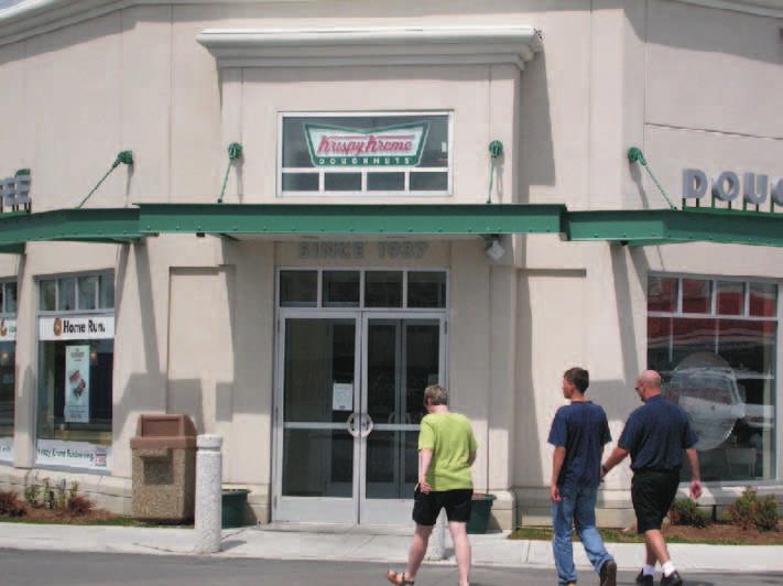
4 The Forum drive-in, Kansas K City,, Missouri, 1930's Melody Lane Restaurant, Coctail Room, Car Service, Los Angeles, California, 1930's The Pig Stand, Dallas Texas, early 1920's Mcdonnell's drive-in, Los Angeles, California, 1930 Simon's drive-in, Los Angeles,, California, 1930's ii DRAFT
5 1.0 INTRODUCTION The drive-through type developed in the United States as a descendent of the gas bar, and drive-in restaurant. Emerging in the 1920's, these early types were experiments in the relationship between commerce and the car at a time when the car and its impact on urban form and experience was emerging as a widespread phenomenon. The first drive-in, The Pig Stand, opened in 1921 as a restaurant in Dallas, Texas, offering road-side service which evolved to head-in parking by The early 1930's saw the advent of the drive-up bank window in Los Angeles, and the first drive-in movie theater in Camden, New Jersey. Macdonald's opened it's first road-side drive-in in 1946 in San Bernadino, California, the first of many restaurants that would evolve to a road-side prototype by 1953, complete with life-sized golden arches designed to attract vehicular traffic and the economy kitchen, inventing the formula for fastfood franchising. The first drive-through restaurant, In-N-Out Burger, opened in 1948 in present day Baldwin Park, California (incorporated in 1956). Architecturally, this type underwent an important development in the 1930's evolving from the small, ad-hoc, road-side stands of the 1920's. Architects embraced the car as the promise of the new, mechanized and modern, creating Streamlined Art Moderne drive-in designs. Typical characteristics included elegant, linear surface definition, a 'scientific' circular plan which efficiently allowed each parked car to be equidistant from the centralized kitchen and a tower element to attract cars travelling at high speeds from a distance. Designs for drive-ins by significant architects such as Richard Neutra and Frank Lloyd Wright included carefully composed lighting and mirrors to heighten the spectacle of the moving car by night, inscribing it into the experience of the architecture. An article entitled 'Is Main Street Doomed?' published in Popular Mechanics in 1931 described Lloyd Wright's theory that city planning could be revolutionized by this new means of individual transportation, allowing each citizen to move about the city purchasing goods without ever leaving the car. Our contemporary perspective allows us to easily evaluate these kinds of early planning notions as, at best, undesirable or unsustainable. The 1930's architectural exploration of the relationship between built form and the car turned it's back on the street, however it's emphasis on high quality design is worth re-capturing and re-inventing for our contemporary City, in the context of site and building design that relates to and supports the public realm. Drive-throughs emerged in the mid-1980's, in the more suburban parts of Toronto as new and retrofitted restaurants. An exception was Aspen Cleaners which opened the first drive-through dry cleaners in Canada in Yorkville in Since that time, drive-throughs have undergone rapid proliferation, with the industry currently seeking to construct new drive-through facilities and retrofit existing businesses with drive-throughs. The range of uses has also continued to expand including restaurants, cafes, banks, financial institutions, dry-cleaners and pharmacies. From the inception of this type as a road-side food stand with curb service, it has responded for the most part to the primary goal of attracting and servicing vehicular customers, largely in an arterial or freeway context. The advent of the drive-in was a response to the desire to service the vehicular customer in their car while avoiding traffic congestion at the curb, with the drivethrough as a further evolution. This resulted in a new kind of site plan, frequently with the building set back from the street to provide space for parked or stacked cars. The initial relationship between the building and the street was lost as site plans became internally and functionally focused. This type of site plan arrangement, where cars are encouraged to cross from the road into the lot en masse, lacking sufficient built form at the street edge and visually dominated by cars, results in an uninviting pedestrian environment along the public street. Adverse effects associated with this use such as traffic, noise, air and light pollution and litter need to be mediated to ensure drive-through facilities enhance and do not detract from a vital public realm. Beginning in the 1990s municipalities including the City of Chicago, Town of Oakville and City of Mississagua responded with new statutory regulations and/or design guidelines to mitigate the effects of drive-through development. The City of Toronto amended its Zoning By-laws in 2002 (upheld by the OMB in 2004) to define drive-through facilities as a use and establish areas where drive-through development is permitted. The Urban Design Guidelines for Sites with Drive-through Facilities complement the Zoning By-laws, assisting proposed drive-through developments take the next step in their evolution to meet the goals of the Official Plan respecting built form and the creation of a safe and high quality public realm where pedestrians, cyclists and transit use are encouraged. April 29,
6 2.0 THE PURPOSE OF THE GUIDELINES These Guidelines will assist in achieving Official Plan goals for city beautification and enhancement and creation of a comfortable, safe and vital pedestrian environment which encourages walking and transit use, as well as specific built form policies as they relate to drive-through uses. These Guidelines implement both in-force Official Plans and the new Official Plan of the City of Toronto. Urban Design Guidelines have been developed for certain areas of the City and building types, including sites with drive-through facilities, to address specific issues and challenges common to them. The Official Plan provides goals and strategies for the City's re-urbanization over the next 30 years. One key strategy for achieving re-urbanization is improvement of the public realm through decreasing the dependence on the car and balancing the need for vehicular transportation with the creation of a vital public realm. These Urban Design Guidelines will assist developers, architects, landscape architects, urban designers and professional planners in making informed decisions when developing site plan applications. They establish principles and criteria for consistent review of development applications for sites with drivethrough facilities by city staff, in those areas of the City where they are a permitted land use, by: Clarifying the City's interest in addressing the development impacts of sites with drive-through facilities; Establishing standards and criteria for the design of sites with drive-through facilities, integrating operational elements, site and built form design with a focus on assisting this use with making a positive contribution to the surrounding context and pedestrian streetscape. 3.0 URBAN DESIGN CHALLENGES FOR SITES WITH DRIVE-THROUGH FACILITIES Designed to enhance the operational efficiency of catering to vehicular customers, the site plan organization and built form of existing sites with drive-through facilities in general do not support, and in many cases detract from urban design goals for the public realm. These guidelines encourage the evolution of this type to balance the functional needs of drive-through facilities with Official Plan Goals for the public realm. The following issues that generate public concern are associated with drive-through facilities: traffic noise and light pollution reduction of air quality environmental degradation odour conflicts between pedestrian and automobile circulation visual impact littering and waste site servicing hours of operation This land use was not anticipated by previous Zoning By-laws. In response, the City of Toronto enacted zoning amendments in 2002 to define drive-through facilities as a separate land use, establish zones where they are and are not permitted and establish a minimum separating distance from the boundary of zones permitting residential uses. The amending zoning was brought into force by an Ontario Municipal Board decision (January 2004). Council directed City staff to develop Urban Design Guidelines for Sites with Drive-through facilities to complement these by-law amendments. These Guidelines set out the principles and criteria, which will help sites with drive-through facilities to meet policy directions for an improved public realm. 2 DRAFT
7 4.0 HOW AND WHERE GUIDELINES APPLY These Guidelines should be used for the development and review of Site Plan Applications for drive-through facilities on lands where the Zoning By-laws identify drive-through facilities as a permitted land use. In addition to meeting the requirements of the applicable Zoning By-law, development applications for drive-through facilities must meet the requirements of the Guidelines as set out in this document, including the provision of studies according to the criteria provided in Appendix B, a Letter of Credit for landscape installation and a landscape maintenance clause as set out in Section of this document. The ability to meet these Guidelines does not constitute permission to allow the development of drivethrough facilities in areas of the City where they are not a permitted land use. However, these Guidelines should be consulted by City staff when considering Official Plan Amendment, Zoning By-law Amendment and minor variance applications for drive-through development to ensure that if such an application is considered appropriate on the basis of the broader planning and urban design considerations underlying the Zoning By-law Amendments (which defined and identified the locations where drive-through facilities are a permitted use), any such application will also have to meet these Guidelines. Zoning By-laws throughout the City of Toronto prohibit development of drive-through facilities: In residential or mixed-use zones containing residential permissions; In designated Centres of North York, Scarborough, Etobicoke, Yonge/Eglington and the Downtown of the former City of Toronto. These prohibitions continue to apply regardless of whether a development application has the ability to meet the Guidelines contained in this document. Zoning By-laws throughout the City of Toronto permit development of drive-through facilities in industrial and commercial zones provided that: A 30 meter separation distance is provided from all parts of the drive-through facility, including stacking lanes, to the edge of the lot line of any residential use or zone where residential uses are permitted; All other applicable regulations of the Zoning By-law are met. April 29,


8 5.0 URBAN DESIGN GOALS POLICY: OFFICIAL PLAN, PUBLIC REALM SECTION City streets are a significant public open space that serve pedestrians and vehicles, provide space for public utilities and services, trees and landscaping, building access, amenities such as view corridors, sky view and sunlight, and are public gathering places. Streets will be designed to perform their diverse roles, balancing the spatial needs of existing and future users within the right of way. This includes pedestrians, people with mobility aids, transit, bicycles, automobiles, utilities and landscaping. POLICY: OFFICIAL PLAN, BUILT FORM SECTION Developers and architects have a civic responsibility to create buildings that not only meet the needs of the clients, tenants, and customers, but also the needs of the people who live and work in the area who will encounter the buildings in their daily lives. Developments must be conceived not only in terms of the individual building site and program, but also in terms of how that building and site fit within the context of the neighbourhood and the City. Each new building should promote and achieve the overall objectives of the Plan. The Urban Design Guidelines for Sites with Drivethrough facilities have three principal urban design goals: To support, enhance, and create a high quality public realm; To support and enhance the pedestrian environment and pedestrian connections; To encourage development that fits well with and improves its existing or planned context. These Guidelines assist sites with drive-through facilities to achieve Official Plan goals of a comfortable, safe and attractive City-wide pedestrian network and high quality public realm. When streets are inviting to pedestrians, street life activities become more vital and in turn contribute to the safety and economic health of local areas. One of the challenges for drive-through development is to balance the needs of motorized vehicles with those of pedestrians including public transportation and bicycles. Key aspects of good site design that helpto achieve a high quality public realm include the following: Locating buildings at the street edge; Locating main entrances at the street with a direct route from the public sidewalk; Separating vehicular and pedestrian traffic; Locating stacking lanes, driveways, parking, utilities and services away from the street, and; Enhancing pedestrian amenity, accessibility and safety. 4 DRAFT

9 A careful examination of the existing and planned context should be carried out prior to developing the design for a drive-through facility. In areas where the local context is evolved and meets Official Plan objectives by making a positive contribution to the public realm, drive-through development should be designed to respect, support and improve the local context. In areas where local context is undeveloped or does not meet Official Plan public realm objectives, drivethrough development should be designed to establish a high quality public realm. April 29,
10 6.0 These guidelines should be read in conjunction with the Official Plan. All other documents referenced in these Guidelines are provided on the City of Toronto website, or by the local area planner. 6.1 SITE PLAN ORGANIZATION, BUILDING LOCATION AND SITE CIRCULATION POLICY: OFFICIAL PLAN, BUILT FORM SECTION New development will locate and organize vehicle parking, vehicular access, service areas and utilities to minimize their impact on the property and on surrounding properties and to improve the safety and attractiveness of adjacent streets, parks and open spaces. New development will be massed to fit harmoniously into its surroundings and will respect and improve the local scale and character. It will minimize the impact on neighbouring buildings and open space. When buildings are located close to the street and the length of building facades along that street are maximized, individual buildings work together with adjacent buildings to create a clearly defined street edge. By locating main entrances at the public boulevard, pedestrians can easily access local businesses and amenities and are encouraged to walk along the street. Locating active uses such as shops, cafes and restaurants that are open in the evening along the street creates overlook or 'eyes on the street' promoting safety and in turn, encouraging more pedestrian activity. These combined measures contribute to the interest and vitality of the public street. Placing parking, driving and stacking lanes away from the street, as well as minimizing curb cuts allows for uninterrupted, safe and inviting pedestrian access to multiple storefronts. Placing utilities and services away from the street ensures that servicing activities have a minimal impact on pedestrian amenity and access. 6 DRAFT

11 6.1.1 LOCATION OF THE BUILDING RELATIVE TO THE STREET AND NEIGHBOURING BUILDINGS Placing drive-through activities away from the street permits the alignment of building faces along the street to create good street edge definition. Landscaping contributes to a comfortable and attractive public realm When designing sites with drive-through facilities: building placement relative to the street should take into account both planned and existing context generally, locate buildings close to or at the street to define and support the street edge and align new buildings with the front facades of existing buildings locate the building adjacent to the property line (of both streets on a corner lot) where a setback is not required by the Zoning By-law align the building to the front setback line (of both streets on a corner lot) where a setback is required by the Zoning By-law locate new buildings as close to the street edge as appropriate with regard for the planned context and an appropriate transition in setback from existing, adjacent buildings to the street, where a setback is required by the Zoning Bylaw and existing context has significantly larger setbacks than planned context * * consider setting back the building from the street, when not required by the Zoning Bylaw, only if the location of the building and the setback contribute positively to, and enhance the public realm and fit well with the local context April 29,

 make walls along the street face and visible from the street, transparent with windows, doors and other forms of")


12 6.1.2 ORGANIZATION OF THE BUILDING TO SUPPORT THE STREET Drive-through sites and buildings should be designed to: locate the main entrance door directly off the public sidewalk within easy access of TTC stops locate the main entrance door at the corner or on the more major street, on a corner lot locate uses that support the street along the public sidewalk (such as restaurant seating or offices) make walls along the street face and visible from the street, transparent with windows, doors and other forms of transparent building materials to maximize views in and out of the building and the relationship between interior and exterior to support and animate the public street and sidewalk Locate active internal uses and provide glazing along the street. Building transparency along the street animates and provides safety to the pedestrian realm. Provide pedestrian amenity between the building and the street where a setback is required by the Zoning By-law. Glazing along the street promotes a safe pedestrian environment. 8 DRAFT


13 6.1.3 STACKING LANES AND DRIVEWAYS When designing sites with drive-through facilities: do not locate stacking lanes or driveways between the building and the street where a setback is required by the Zoning Bylaw do not locate stacking lanes or driveways in the setback area between the building and the street locate stacking lanes and driveways out of view of the public street and/or sidewalk, at the rear and/or flank of the building integrate stacking lanes and driveways into the larger landscape and streetscape concept provide a minimum of 10 stacking spaces on site for restaurant and food sale use drive-through facilities* provide a minimum of 4 stacking spaces on site for banking, pharmacies and similar non-food related use drive-through facilities* provide stacking spaces which are 3.5 meters in width and 6.5 meters in length minimize paved areas, such as stacking lanes and maximize water permeable surfaces and soft landscaped areas to contribute to the appearance and environmental sustainability of the site and its larger context by increasing water penetration into the water table, reducing pollution of local water features and runoff demand on local infrastructure multiple windows servicing a single stacking lane (e.g. order window, payment window, pickup window) should be considered to promote reduced idling multiple stacking lanes for a single user are discouraged provide sufficient signage where necessary to indicate direction of vehicular travel, stop signs or no entrance areas Placing stacking lanes at the rear or flank of the building allows space for lanscaped screens. Placing stacking lanes at the rear or flank of the building maintains clear, safe and attractive pedestrian access. * the number of required stacking spaces may change as a result of studies required as part of the approvals process as outlined in Section 7.0 of this document Minimizing paved areas such as stacking lanes, driveways and parking allows for maximizing soft landscaping and pedestrian amenity. April 29,


14 6.1.4 VEHICULAR SITE ACCESS AND PARKING When designing a drive-through facility: minimize the number and width of curb cuts provide only one curb cut for a mid-block site and a maximum of two curb cuts, if necessary for a corner site coordinate vehicular site access with existing curb cuts where it results in good site and traffic operations design provide the minimum width of curb cuts required by the City of Toronto Access Management Guidelines refer to the City of Toronto Access Management Guidelines for site access requirements provide vehicular site access from the side or less major street where possible, to improve pedestrian safety on the major street sidewalk locate parking at the rear and/or flank of the building out of view of the public street and/or sidewalk do not locate parking or vehicular site exits or entrances between the building and the street provide parking adjacent to the secondary entrance doors to the facility such that it is not necessary for pedestrians who arrive by car to cross driveways or stacking lanes to enter the interior of the building integrate parking into the larger landscape and streetscape concept minimize paved areas, such as parking and driveways and maximize water permeable surfaces and soft landscaped areas to contribute to the appearance and environmental sustainability of the site and its larger context by increasing water penetration into the water table, reducing pollution of local water features and runoff demand on local infrastructure the amount of parking should conform with the minimum required by the zoning by-law or an alternative standard reached through the development approvals process refer to the City of Toronto Urban Design Guidelines for Surface Parking Lots 10 DRAFT Secondary entrances from the parking should provide safe comfortable access, that does not require crossing of stacking lanes or driveways. Secondary entrances from the parking should provide safe comfortable access, that does not require crossing of stacking lanes or driveways. Provide canopies, secondary entrances and well designed pedestrian spaces at the rear of flank of the building in direct connection with parking.


15 6.1.5 UTILITIES AND SERVICES Integrate servicing and garbage storage into the mass of the building. To ensure that utilities and service components are not visible from the street and other public areas such as the larger site, adjacent park or open spaces and are out of view from the public street and/or sidewalk: locate utilities underground if possible locate utilities and services such as transformers, loading and garbage pick up at the rear or flank of the building and integrate into the site design and landscape concept coordinate above ground and below ground utilities and appurtenances with landscaping integrate utilities and services such as garbage facilities, utility meters and connections into the mass of the building house exterior garbage facilities in enclosed structures, integrated into the building, with roofs, reinforced metal doors provide cladding materials for exterior garbage facilities that are durable and match or are complementary to the main structure Garbage and loading facilities massing can be articulated as an integral aspect of the building's expression. April 29,

16 6.2 MASSING AND BUILDING ARTICULATION Well designed massing and articulation of building elements are integral to achieving a high quality public realm. Proposed sites with drive-through facilities should demonstrate building massing and articulation which enhances and improves its context and is responsive to pedestrian scale and the public aspect of the street. The proposed building's massing and articulation should be sensitive to surrounding context and should take into account planned context. On sites where no built form context exists, new proposals should establish a high quality public realm. The building's height relative to the street width should be sufficient to define the street edge and corner, on a corner site. The building, through its massing and articulation should seek to animate the street, direct pedestrians, terminate view corridors, frame views, enclose space, provide visual relief and create or extend the street wall. Prototypical buildings should be avoided. Instead, appropriate building types and expressions should be developed to address individual site conditions and local contexts. POLICY: OFFICIAL PLAN, BUILT FORM SECTION New development should be massed to define the edges of streets, parks and open spaces at good proportion. Corner sites should acknowledge and support both streets. Atriculated building entrances direct pedestrians and create a sense of arrival. 12 DRAFT


 Creative use of massing and building articulation allows for incorporation of signage, providing")
17 6.2.1 MASSING AND BUILDING ARTICULATION As permitted by the Zoning By-law building massing and articulation should: maximize the height of the building or facades facing the street (i.e. by maximizing ceiling height, parapet height and through roof design), to achieve an appropriate scale to define the street maximize the length of the building at the front lot line or setback line (at both streets on a corner lot) Creative use of massing and building articulation allows for incorporation of signage, providing identity to the building and animating the street. The overall proportion of the building relative to the street width is increased, creating better street edge definition. where possible, avoid stand alone buildings and incorporate the building and drive-through facility into larger, multi-use buildings provide a two storey building where necessary to be compatible with planned context provide materials and methods of contstruction that are high quality and where appropriate, relate to their surrounding context articulate all building facades facing or visible from the public street and/or sidewalk articulate building entrances and distinguish main entrances incorporate weather protection devices such as canopies into the building expression In areas with no existing context, drive-through developments should establish a high quality public realm. incorporate canopies for stacking lanes associated with the pick up window area, at an appropriate scale, into the massing and expression of the building incorporate signage into the massing and articulation of the building through devices such as canopies, towers or other building elements integrate signage into the site design and landscape concept as well as take advantage of opportunities to share existing signage structures on larger sites screen rooftop mechanical devices from view from the street or public sidewalk A well massed and articulated building contributes to a high quality public realm. ARCHITECTURAL TREATMENT It is best to avoid a superficial treatment; frank expression of structure can often make an arresting design. Architectural Record, August, 1950 'Building Type Study Number 161: Drive-Ins, Banks, Theatres, Restaurants' April 29,

18 6.3 PEDESTRIAN SAFETY, AMENITY AND CIRCULATION POLICY: OFFICIAL PLAN, BUILT FORM SECTION New development will provide amenity for adjacent streets and open spaces to make these areas attractive, interesting, comfortable, and functional for pedestrians POLICY: EXERPT FROM PEDESTRIAN CHARTER ADOPTED BY CITY COUNCIL IN 2002 To create an urban environment in all parts of the city that encourages and supports walking, the City of Toronto: upholds the right of pedestrians of all ages and abilities to safe, convenient, direct and comfortable walking conditions; provides a walking environment within the public right-of-way and in public parks that encourages people to walk for travel, exercise and recreation; supports and encourages the planning, design and development of a walking environment in public and private spaces (both exterior and interior) that meets the travel needs of pedestrians; provides and maintains infrastructure that gives pedestrians safe and convenient passage while walking along and crossing streets; ensures that residents access to basic community amenities and services does not depend on car ownership or public transit use; sets policies that reduce conflict between pedestrians and other users of the public right-of-way; creates walkable communities by giving high planning priority to compact, human-scale and mixed land use; To ensure pedestrian safety and comfort, sites with drive-through facilities should be organized so that it is not necessary for pedestrians to cross stacking lanes, driveways or parking when accessing the site from adjacent streets. The design of the site, building and landscape should provide barrier-free accessibility from the public sidewalk to the building interior. Pedestrian amenities such as seating areas, phone booths and weather protection should be provided in conjunction with landscaping to enhance and extend the function of the site and public sidewalk. 14 DRAFT

 should take into consideration the safety of site users, employees, and passers by on the street and adjacent")

19 6.3.1 PEDESTRIAN SAFETY, AMENITY AND CIRCULATION To ensure that sites with drive-through facilities enhance pedestrian amenity and are designed to provide and not detract from a safe environment for users, employees, adjacent uses and pedestrians on public sidewalks: Provide weather protection overhangs at entrances. Combine with plantings, cigarette bins, garbage boxes and public phones to promote pedestrian use. Glazed canopies with integrated lighting and signage promote pedestrian use. the design of the site and building (including the building's internal organization) should take into consideration the safety of site users, employees, and passers by on the street and adjacent sites, to maintain appropriate sight lines, surveillance and lighting during the day and at night provide and clearly demarcate separate, safe pedestrian circulation routes in conjunction with vehicular circulation for the drive-through facility and larger site using techniques such as raised pedestrian crossings, change in paving, bollards and landscaping to separate them from stacking lanes and driveways provide pedestrian circulation routes that are a minimum of 1.5 meters wide and barrier-free accessible as defined by the Ontario Building Code ensure barrier-free pedestrian access as defined by the Ontario Building Code, from the public street into the building provide rain, wind and shade weather protection (i.e. canopy) at the main building entrance and in proximity to public transit stops, for exterior seating areas, along the street and for specific pedestrian amenity associated with the building where a setback is required by the Zoning Bylaw, provide exterior places of repose, with an eating area (tables and seating) for restaurant uses within the setback allowance provide pedestrian amenities appropriate for the site including, phone booths, bicycle racks and exterior furniture provide small, low, task related lighting and direct lighting toward the site to avoid spill-over and excessive lighting of adjacent uses while balancing need for sufficient lighting to maintain sight lines at night locate lighting, trees, soft landscaping, exterior furniture along pedestrian walkways through the site indicate lighting and pedestrian amenities on development application drawings and integrate into the larger site design and landscape concept Walkways through the larger site should be separated from vehicular parking, circulation and snow storage. Walkways should be landscaped and well lit. April 29,
20 6.4 LANDSCAPING Landscaping is an effective and relatively inexpensive means of integrating the various functional elements of sites with drive-through facilities, and of integrating the site within its context. Well designed landscaping creates an attractive setting for the building, enhancing the appearance of the site from the street and public sidewalk. Landscaping extends the public street edge, enhancing the area's pedestrian amenity and provides a comfortable and safe pedestrian circulation network with places of repose within the site. All drivethrough developments should provide a high quality landscape and maximize soft landscaping opportunities. The landscape design should fit well within its existing and planned context. It should respond to the surrounding cultural landscape and adjacent or visible natural landscapes in a positive and supportive way. Landscaping should also be used to screen operational elements of the development such as stacking lanes, driveways, parking, utilities and services. Stacking lanes should be defined by landscaping to visually distinguish them from driveways and contribute to pedestrian safety. Pedestrian walkways, patios, seating areas and other pedestrian areas should be landscaped to improve amenity, provide sun and wind protection, and encourage their use. Practical considerations such as adequate, growing medium, irrigation and plant material selection should be taken into account to ensure the viability of the landscaping, increase the range of planting materials and decrease long-term maintenance costs. This is particularly important when considering that many sites with drive-through facilities are franchised operations. The franchisee or site operator should be made aware of his or her obligations to maintain landscape integrity according to the approved landscape plan. TERRACES AND LANDSCAPING Take full advantage of any pleasant view. Outdoor terraces or gardens with tables can be attractive and profitable; many motorists like to get out and 'stretch their legs'. Architectural Record, August, 1950 'Building Type Study Number 161: Drive-Ins, Banks, Theatres, Restaurants' 16 DRAFT


21 6.4.1 GENERAL LANDSCAPING REQUIREMENTS Provide street trees in soft landscape adjacent to the public sidewalk to contribute to the public realm and screen and buffer drive-through activities. Placing drive-through activities away from the street provides opportunity for landscaping for the building and public street edge and enhances the area's pedestrian amenity. When designing landscapes for sites with drivethrough facilities: provide well designed, high quality landscaping, maximizing soft landscaping which is attractive, functional and fits well with its existing and planned context to enhance the appearance of the site from the street and public sidewalk and provide comfortable and safe pedestrian circulation and places of repose provide street trees, boulevard paving, sod and sidewalks as per the City of Toronto Streetscape Manual coordinate on-site landscaping with streetscape improvements in the public boulevard provide a landscaped area between the building and the street when a setback is required by the Zoning By-law provide landscaped areas and opportunities to define the front door of the building and to define the vehicular entrance to the drivethrough site provide continuous soft landscaped areas no less than 2.4 meters in width, to define stacking lanes maintain site lines from stacked cars to pedestrian crossings by providing low soft landscaping in such areas provide a variety of plant material including trees, which meets the requirements of section of this document design the landscaping to respond to adjacent or visible natural landscapes provide a fully functioning irrigation system to ensure adequate watering of soft landscaping and increase the possible range of planting materials while decreasing long-term maintenance costs and ensuring the viability of the landscaping April 29,


22 6.4.2 EDGE TREATMENT AND SCREENING Edge treatment is sometimes needed at the street edge, other public edges, boundaries with adjacent sites and different land use areas. These edges typically need screening such as landscaping to mitigate visual and other sensory impacts from drive-through uses. An adequate amount of land needs to be provided to accommodate required landscaping along these edges. Along the Street: Generally, buildings should form the street edge. It is important to screen views from the street edge of stacking lanes, driveways, parking, utilities and services to maintain an attractive and unified experience of the streetscape from the street. Trees and other soft landscaping should be planted to complement other screening measures. Mass plantings of hearty perennials can provide all season interest. Abutting Parks, Open Spaces and other Public Areas not Along the Street: A landscaped transition area should be provided between a drive-through facility and public open space. Existing trees should be preserved as a priority in these areas. Where natural or naturalized areas exist, the landscaping on the drive-through site should be designed to respect and support it by providing native planting. Stacking lanes, driveways, parking, utilities and services should be screened from view of public areas. Fencing may also be required to satisfy requirements of the City of Toronto Parks. Provide a variety of coniferous and deciduous plantings. 18 DRAFT

 including low decorative fences or walls with continuous screening hedges")
23 Where context or site size limits landscaping, provide attractive and durable fencing, shrub and tree planting to screen parking along the street edge. Provide a 1.8m high fense screen in addition to landscaping to provide separation between adjacent uses and the drive-through site where required. When designing sites with drive-through facilities: screen stacking lanes, driveways, parking, utilities and services including transformers, gas meters, loading and garbage pick up from view along the street and/or sidewalk, larger site or adjacent uses with landscaping; provide screening (900mm to 1100mm in height) including low decorative fences or walls with continuous screening hedges maintained between 800mm to 1000mm in height, locate screening at least 1000mm from the edge of the public sidewalk, provide trees where possible, use high branching deciduous trees where it is necessary to maintain site lines on the larger site, screen any parking along street edges (if provided) with landscaping as shown in the City of Toronto Streetscape Manual and/or Urban Design Handbook ensure screening design, height and materials relate to the building expression, the character of the area, the surrounding streetscape and planned context provide no less than a 3.0 meter wide landscaped area along the perimeter at the back and sides of the site to accommodate tree planting, fencing, snow storage requirements, etc. A greater width may be required where these requirements overlap, under change of grade conditions, or where walkways and other spatial needs are identified provide tree planting in perimeter landscaped areas at a rate of one tree per 7.5 meters of linear frontage preserve existing trees wherever possible allow for flexibility in tree spacing plant trees 600mm (minimum) from any curb face or parking lot edge to protect from car overhang and mechanical damage provide mediating measures such as sound attenuation fences with soft landscaping at back and side site edges where required and appropriate April 29,

24 6.4.3 SITE GRADING When designing sites with drive-through facilities: avoid making changes in grade, greater than 4% slope, between the public sidewalk and adjacent uses to maintain direct pedestrian access to the building and site and not detract from visual access between the building interior or site's pedestrian amenities and the public realm where site specific conditions dictate that a change in grade for a site with a drive-through facility cannot be avoided; the grade change should be located away from the public sidewalk in areas where pedestrian access does not occur, where site specific conditions dictate that it is not possible to locate a grade change away from the public sidewalk the grade change should be minimized, and direct, barrier-free access to the building entrance should be maintained through devices such as ramps (refer to the Ontario Building Code and the City of Toronto Accessibility Guidelines), enhance areas of grade change with intensive soft landscaping use durable and attractive materials such as precast concrete or better for retaining walls (pressure treated wood is not an acceptable material) incorporate landscaping for grade changes into the larger landscape concept Where grade changes between the building and sidewalk cannot be avoided, set back the building and create landscaped terraces of attractive and durable materials that are integrated with the building materials and expression. 20 DRAFT
25 6.4.4 PLANT MATERIAL When designing the landscape for sites with drivethrough facilities: install only plant material grown in nurseries having the habit and growth typical for the species and comply with the Canadian Standards for Nursery Stock (Canadian Nursery Landscape Association) install only plant material that is healthy and vigorous, free from insects, plant diseases and injuries install plant material that meets or exceeds the following minimum sizes, requirements may be increased through the development approvals process for design reasons: deciduous street tree deciduous trees small deciduous trees coniferous trees deciduous shrubs coniferous shrubs perennials 70mm caliper 60mm caliper 50mm caliper 1500mm ht. 600mm ht. 600mm ht. or spread 2 years container grown provide quality and volume of growing medium appropriate to the specified plant material and as required by the City of Toronto Streetscape Manual consider hardiness of plant material appropriate for local sun and shade conditions, seasonal conditions and pollution from cars consider plant material size at initial planting and expected maturity avoid using invasive plant species; limit exotic species near natural areas; and provide species diversity to an appropriate degree within the larger community or district April 29,
26 6.4.5 LANDSCAPE MAINTENANCE The owner of the property, tenant or drive-through operator, his/her successors, heirs and assignees are responsible for the proper maintenance of the drivethrough site (and adjacent parking areas if applicable) landscaped areas, materials, installations and equipment, as shown on the approved landscape plan, in a condition acceptable to the City. Landscaping must be continuously maintained including necessary irrigation, weeding, pruning, pest control and replacement of dead or diseased plant material. Replacement of dead or diseased plant material shall be of the same type, same scale and visual character of plant material as set forth in the approved landscape plan. Replacement shall occur no later than the next planting season, when it is not possible or appropriate to replace during the current growing season. Replacement time must not exceed one year. As provided for by the Planning Act (Section 41.7), a maintenance clause setting out the above requirements will be included as a condition of development approval to ensure continued maintenance of the approved landscape plan.. 22 DRAFT

27 6.4 SITE PLAN DIAGRAMS CORNER LOT SITE PLAN DIAGRAM CONTINUOUS LANDSCAPED PERIMETER WITH SCREENING PAVED FORECOURT WITH SEATING CONTINUOUS CANOPY LOW LANDSCAPING TO MAINTAIN SITELINES TO PEDESTRIAN CROSSING RAISED PEDESTRIAN CROSSING ATM or Pick-up window Low wall with soft landscaping Public transit stop Tree Building entrance Landscaped island with pedestrian walk Raised pedestrian crossing Canopy Direction of vehicular travel Pedestrian walkway Low hedge Zone of interior active uses with glazed wall Exterior seating Property line Stacked car Zone of interior services April 29,

28 6.4.2 MID BLOCK SITE PLAN DIAGRAM SOFT LANDSCAPED ISLAND CONTINUOUS LAND- SCAPED PERIMETER WITH SCREENING PEDESTRIAN ACCESS AND PLACE OF REPOSE RAISED PEDESTRIAN CROSSING LOW SCREENING OF PARKING LOW LANDSCAPING TO MAINTAIN SITE LINES TO PEDESTRIAN CROSSING EXTERIOR EATING AREA WITH CONTINUOUS CANOPY ATM or Pick-up window Low wall with soft landscaping Public transit stop Tree Building entrance Landscaped island with pedestrian walk Raised pedestrian crossing Canopy Direction of vehicular travel Pedestrian walkway Low hedge Zone of interior active uses with glazed wall Exterior seating Property line Stacked car Zone of interior services 24 DRAFT

29 6.4.3 FRONT OF MALL SITE PLAN DIAGRAM SOFT LANDSCAPED ISLANDS WITH CONTINUOUS PEDESTRIAN WALKWAY LANDSCAPED SCREEN- ING OF THE STACKING LANE FROM THE STREET EDGE DIRECT PEDESTRIAN WALKWAY FROM PARKING WITH CONTINUOUS CANOPY ATM or Pick-up window Low wall with soft landscaping Public transit stop Tree Building entrance Landscaped island with pedestrian walk Raised pedestrian crossing Canopy Direction of vehicular travel Pedestrian walkway Low hedge Zone of interior active uses with glazed wall Exterior seating Property line Stacked car Zone of interior services April 29,
30 7.0 APPENDICES 7.1 DEFINITIONS A number of Zoning By-law amendments were encacted for the former municipalities comprising the City of Toronto, defining 'drive-through' as a distinct land use. While wording differs to address local zoning, the Zoning By-law amendments provide standard definitions, use permissions and prohibitions for drive through-facilities in the City. For example, By-law which amends Bylaw for the former City of Toronto provides as follows: DRIVE-THROUGH FACILITY: "Drive-through Facility" means the use of land, buildings or structures, or parts thereof, to provide or dispense products or services, either wholly or in part, through an attendant or a window or automated machine, to persons remaining in motorized vehicles that are in a designated stacking lane. A drive-through facility may be in combination with other uses such as, laundry shop, dry cleaning shop, dry cleaner's distributing station, branch of a bank or financial institution, restaurant, retail store, automotive service station, or take-out restaurant. Despite the above, a drive-through facility does not include a car washing establishment, automobile service station or a gas bar. If the use of any land, building or structure is composed of a combination of drive-through facility and any one or more other uses, those uses shall not be construed as accessory to one another and all provisions pertaining to each use shall apply. STACKING LANE: "Stacking Lane" means an on-site queuing lane for motorized vehicles which is separated from other vehicular traffic and pedestrian circulation by barriers, markings or sign. 26 DRAFT
31 7.2 APPENDIX B: STUDY SUBMISSION REQUIREMENTS Traffic studies in accordance with the City of Toronto Development Guide, will be required as part of all development application for drive-through facilities to appropriately evaluate the proposed development.additional studies that may be required include, but are not limited to the following: Air Quality Study Noise Impact Study For Study Terms of Reference refer to the Toronto Development Guide, Appendix 3. April 29,
32
Urban Design Manual 2.0 DRIVE-THROUGH FACILITIES. Background. Urban Design Challenges
 222221 2.0 DRIVE-THROUGH FACILITIES Background In recent years, drive-through facilities have grown significantly in popularity with drive-through restaurants, in particular, being established on numerous
Gas Stations ottawa.ca
 Urban Design Guidelines for Gas Stations ottawa.ca Ce document est disponible en français sur ottawa.ca. This document is available in French on ottawa.ca. Approved by City Council May 24, 2006 City of
Commercial Development Permit Area
 City of Kamloops KAMPLAN Commercial Development Permit Area PURPOSE The purpose of this Development Permit Area (DPA) is to establish objectives and provide guidelines for the form and character of commercial
ELMVALE ACRES SHOPPING CENTRE MASTER PLAN
 ELMVALE ACRES SHOPPING CENTRE MASTER PLAN Contents 1.0 INTRODUCTION... 2 2.0 LOCATION... 2 3.0 EXISTING CONTEXT... 2 4.0 VISION & GUIDING PRINCIPLES... 2 5.0 LAND USE AND BUILT FORM... 4 5.1 St. Laurent
GUIDELINES REPLACEMENT HOUSING GUIDELINES LOCATION INTRODUCTION URBAN DESIGN GUIDELINES
 Replacement housing in the former City of North York will be consistent with the following urban design guidelines. They provide a framework for residential re-development in the former City of North York
Clairtrell Area Context Plan
 Clairtrell Area Context Plan March 2005 Urban Development Services City Planning Contents 1. Introduction... 4 2. Development Structure... 6 2.1 Streets... 7 2.1.1 Sheppard Avenue and Bayview Avenue...
Wide asphalt driveway abutting school property. garage built with incompatible materials, too close to park. incompatible fencing materials
 Wide asphalt driveway abutting school property incompatible fencing materials garage built with incompatible materials, too close to park Lack of plantings as a buffer between private property and open
Policies and Code Intent Sections Related to Town Center
 Policies and Code Intent Sections Related to Town Center The Town Center Vision is scattered throughout the Comprehensive Plan, development code and the 1994 Town Center Plan. What follows are sections
Bylaw A Bylaw to amend Bylaw 12800, as amended, The Edmonton Zoning Bylaw Amendment No. 2239
 Bylaw 17672 A Bylaw to amend Bylaw 12800, as amended, The Edmonton Zoning Bylaw Amendment No. 2239 WHEREAS City Council at its meeting of February 22, 2001, gave third reading to Bylaw 12800, as amended;
Urban Design Guidelines for Large-Format Retail
 Urban Design Guidelines for Large-Format Retail May 2006 Compte tenu de la nature de ce document, il n'est disponible qu'en anglais. La Ville pourra, sur demande, traduire ce document au complet ou en
(DC1) Direct Development Control Provision DC1 Area 4
 Direct Development Control Provision DC1 Area 4") . General Purpose (DC) Direct Development Control Provision DC Area 4 The purpose of this Provision is to provide for an area of commercial office employment and residential development in support of the
. General Purpose (DC) Direct Development Control Provision DC Area 4 The purpose of this Provision is to provide for an area of commercial office employment and residential development in support of the
CITY OF MERCER ISLAND DESIGN COMMISSION STAFF REPORT
 CITY OF MERCER ISLAND DESIGN COMMISSION STAFF REPORT Agenda Item: 2 March 9, 2011 Project: Description: Applicant: DSR11-004 The applicant is requesting approval to replace the existing exterior wood framed
Bel-Air Lexus Automobile Service Station
 Bel-Air Lexus Automobile Service Station Design Brief 443-447 McArthur Avenue Ottawa April 30, 2015 14-1299-MCA Site Details Application: Site Plan Control Legal Description and Municipal Addresses: 443
599 Kennedy Road - Official Plan Amendment and Zoning Amendment Application - Preliminary Report
 STAFF REPORT ACTION REQUIRED 599 Kennedy Road - Official Plan Amendment and Zoning Amendment Application - Preliminary Report Date: March 7, 2017 To: From: Wards: Reference Number: Scarborough Community
Highland Village Green Design Guidelines
 Highland Village Green Design Guidelines Publishing Information Title Highland Village Green Design Guidelins Author The City of Calgary Status DRAFT - Proposed document subject to changes Additional Copies
PUBLIC RIGHT-OF-WAY IN THIS CHAPTER PUBLIC REALM
 PUBLIC RIGHT-OF-WAY This section provides design guidelines for improvements in the public right-of-way. The public right-of-way refers to streets, sidewalks, non-vehicular thoroughfares, parks and greenways
appendix and street interface guidelines
 appendix five: building and street interface guidelines appendix 5 building and street interface guidelines BOULEVARDS Boulevards are generally characterized by higher levels of traffic movement at higher
Housing and Coach House Guidelines - Ladner
 Housing and Coach House Guidelines - Ladner Policy D.8: Encourage Compatible Housing Design Encourage housing design that is sensitive to existing single family housing neighbourhoods by requiring a design
URBAN DESIGN BRIEF REPORT
 URBAN DESIGN BRIEF REPORT PREPARED FOR 2568401 ONTARIO INC NEW GASBAR, CONVENIENCE STORE & CARWASH DEVELOPMENT @ 1509 FANSHAWE PARK ROAD WEST LONDON, ONTARIO GAMA ENGINEERING INC. PROJECT NUMBER 1669 PREPARED
T O W N O F A J A X URBAN DESIGN GUIDELINES FOR MOTOR VEHICLE GAS BARS / SERVICE CENTRES
 T O W N O F A J A X URBAN DESIGN GUIDELINES FOR MOTOR VEHICLE GAS BARS / SERVICE CENTRES June 2006 Table of Contents TABLE OF CONTENTS... 1 1.0 INTRODUCTION... 2 1.1 Purpose... 2 1.2 Organization of the...
FORMER CANADIAN FORCES BASE (CFB) ROCKCLIFFE SECONDARY PLAN. Official Plan Amendment XX to the Official Plan for the City of Ottawa
 ROCKCLIFFE SECONDARY PLAN. Official Plan Amendment XX to the Official Plan for the City of Ottawa") FORMER CANADIAN FORCES BASE (CFB) ROCKCLIFFE SECONDARY PLAN Official Plan Amendment XX to the Official Plan for the City of Ottawa 1 INDEX THE STATEMENT OF COMPONENTS PART A THE PREAMBLE PAGE Purpose...
FORMER CANADIAN FORCES BASE (CFB) ROCKCLIFFE SECONDARY PLAN Official Plan Amendment XX to the Official Plan for the City of Ottawa 1 INDEX THE STATEMENT OF COMPONENTS PART A THE PREAMBLE PAGE Purpose...
Industrial Development Permit Area
 Industrial Development Permit Area PURPOSE The purpose of this Development Permit Area (DPA) is to establish objectives and provide guidelines for the form and character of industrial development in the
VILLAGE OF SKOKIE Design Guidelines for Mixed-Use Districts NX Neighborhood Mixed-Use TX Transit Mixed-Use CX Core Mixed-Use
 VILLAGE OF SKOKIE Design Guidelines for Mixed-Use Districts NX Neighborhood Mixed-Use TX Transit Mixed-Use CX Core Mixed-Use TABLE OF CONTENTS CHAPTER 1 SITE DESIGN Purpose 1 CHAPTER 2 SITE DESIGN Streetscape
Appendix A COMMUNITY IMPROVEMENT PLAN DESIGN GUIDELINES
 Appendix A COMMUNITY IMPROVEMENT PLAN DESIGN GUIDELINES INTRODUCTION The continuous and desirable improvement of Arnprior requires a clear understanding of what is envisioned for the Town. These Design
4. INDUSTRIAL 53 CASTLE ROCK DESIGN
 4. INDUSTRIAL 53 CASTLE ROCK DESIGN CASTLE ROCK DESIGN 54 4. INDUSTRIAL Overview Well-designed and attractive industrial centers are the product of blending economic realities with both functional and
URBAN DESIGN BRIEF. 2136&2148 Trafalgar Road. Town of Oakville
 URBAN DESIGN BRIEF 2136&2148 Trafalgar Road Town of Oakville Prepared By: METROPOLITAN CONSULTING INC For 2500674 Ontario Inc November 2016 TABLE OF CONTENTS Page No. 1.0 Introduction/Description of Subject
4.0 Design Guidelines For The Village Centre. South fields Community Architectural Design Guidelines Town of Caledon
 4.0 Design Guidelines For The Village Centre 4.0 Design Guidelines for the Village Centre The Village Centre is the focal point of the entire South Fields Community and is designed as a traditional commercial
URBAN DESIGN BRIEF URBAN DESIGN BRIEF 721 FRANKLIN BLVD, CAMBRIDGE August 2018
 URBAN DESIGN BRIEF URBAN DESIGN BRIEF 721 FRANKLIN BLVD, CAMBRIDGE August 2018 DESIGN BRIEF CONTENTS PART A 1.0 INTRODUCTION 2.0 DESCRIPTION & ANALYSIS OF SITE CONTEXT 3.0 DESIGN CONSTRAINTS AND OPPORTUNITIES
New-Cast Mixed-use Development Proposal King Street West, Newcastle, Ontario
 URBAN DESIGN BRIEF New-Cast Mixed-use Development Proposal King Street West, Newcastle, Ontario TABLE OF CONTENTS: 1.0 Executive Summary 2.0 Creating Vibrant and Sustainable Urban Places: Excerpts from
AIRPORT BUSINESS PARK
 PIER MAC PETROLEUM INSTALLATION LTD. AIRPORT BUSINESS PARK DEVELOPMENT APPLICATIONS March 2003 4.1 Airport Business Park Development Permit Area 4.1.1 Justification/Design Concept The design concept envisioned
Future Five. Design/ Development Guidelines. January 2008 Amended June 08 per City Council motion
 Future Five Design/ Development Guidelines January 2008 Amended June 08 per City Council motion 5-Points Design Guidelines Table of Contents I. Introduction 3 II. Area boundaries 4 III. Review Process
Urban Design Guidelines Townhouse and Apartment Built Form
 Urban Design Guidelines Townhouse and Apartment Built Form Town of Wasaga Beach Table of Contents 1. Introduction 1.1. Purpose 1.2. Urban Design Principles 1.3. Application of Guidelines 2. Site Design,
DRAFT DESIGN GUIDELINES
 IHZ Booklet #7 May 6, 2010 DRAFT DESIGN GUIDELINES CANTERBURY 7 Overview During the recent planning process for the Plan of Conservation and Development community character was identified as an important
5.1 Site Plan Guidelines
 5. Community Core Guidelines Development of the Community Core will take place by plan of subdivision and site plan approval. It will occur in a phased manner that will reflect the timing of residential
DEVELOPMENT DESIGN GUIDELINES
 DEVELOPMENT DESIGN GUIDELINES Approved by Surrey City Council January 26, 2004 Campbell Heights Business Park - Development Design Guidelines TABLE OF CONTENTS 1.0 DEVELOPMENT CONCEPT... 1 2.0 DESIGN OBJECTIVES...
DRAFT DRAFT DRAFT DRAFT
 # 19 EXPAND GREEN AND OPEN SPACES AND COMMUNITY FACILITIES IN TANDEM WITH NEW DEVELOPMENT The role of Eglinton will change in the coming years, along with the intensity of activity and land uses. As more
CENTERS AND CORRIDORS
 INITIAL DESIGN STANDARDS AND GUIDELINES for CENTERS AND CORRIDORS City of Spokane Planning Services Third Floor, City Hall 808 W. Spokane Falls Blvd. Spokane, WA 99201-3329 (509) 625-6300 www.spokaneplanning.org
built form design guidelines
 built form design guidelines Derry Green Corporate Business Park 17 built form design guidelines.1 Built Form Design Guidelines Section : Built Form Design Guidelines is intended to be used by both developers
Toronto Complete Streets Guidelines
 Toronto Complete Streets Guidelines 108 110 7.1 Green Infrastructure Design Principles 112 7.2 Context-Sensitive Green Streets 114 7.3 Key Green Street Elements Green infrastructure refers to natural and
B L A C K D I A M O N D D E S I G N G U I D E L I N E S for Multi-family Development
 B L A C K D I A M O N D D E S I G N G U I D E L I N E S for Multi-family Development Adopted June 18, 2009 This section of the Design and focuses on site planning and design guidance for new multi-family
Multi family Residential Development Permit Area
 City of Kamloops KAMPLAN Multi family Residential Development Permit Area PURPOSE The purpose of this Development Permit Area (DPA) is to establish objectives and provide guidelines for the form and character
Official Plan Review: Draft Built Form Policies
 PG.30.1 REPORT FOR ACTION Official Plan Review: Draft Built Form Policies Date: May 15, 2018 To: Planning and Growth Management Committee From: Chief Planner and Executive Director, City Planning Division
Cit of Kitchener Ur 6 an Design Manual PARTA. Desi n for _--::
 Cit of Kitchener Ur 6 an Design Manual Date PARTA Year ) Desi n for k Nodes Corridors _--:: Section Page 01 of 12 2 INTRODUCTION Purpose & Application Nodes and Corridors have been identified as key intensification
WEST LOOP DESIGN GUIDELINES CHECKLIST
 WEST LOOP DESIGN GUIDELINES CHECKLIST Section 1.0 General Strategies 1.1 DESIGN EXCELLENCE: ENCOURAGE HIGH QUALITY AND INNOVATIVE DESIGN OF NEW BUILDINGS WITHIN THE WEST LOOP WITHOUT BEING PRESCRIPTIVE
Uptown Rideau Street Secondary Plan [Amendment #166, January 12, 2016]
![Uptown Rideau Street Secondary Plan [Amendment #166, January 12, 2016]](/thumbs/76/73760497.jpg "Uptown Rideau Street Secondary Plan [Amendment #166, January 12, 2016]") [Amendment #166, January 12, 2016] The policies of this Secondary Plan are in effect, save and except for the property at 560 Rideau Street, for which there remains a site specific appeal to this Secondary
[Amendment #166, January 12, 2016] The policies of this Secondary Plan are in effect, save and except for the property at 560 Rideau Street, for which there remains a site specific appeal to this Secondary
PLANNING RATIONALE FOR THE PROPOSED RIVERSIDE SOUTH ELEMENTARY SCHOOL 715 BRIAN GOOD AVENUE, OTTAWA, ON
 PLANNING RATIONALE FOR THE PROPOSED RIVERSIDE SOUTH ELEMENTARY SCHOOL 715 BRIAN GOOD AVENUE, OTTAWA, ON Conseil des écoles publiques de l'est de l'ontario (CEPEO) French Public School Board TABLE OF CONTENTS
WINDSOR GLEN DESIGN GUIDELINES
 WINDSOR GLEN DESIGN GUIDELINES Adopted by Council, 2006 WINDSOR GLEN REDEVELOPMENT DESIGN GUIDELINES August 2006 1.0 Master Plan Organization For this area of the Coquitlam Town Centre, a mix of high,
1296 Kennedy Road - Zoning Amendment Application - Preliminary Report
 STAFF REPORT ACTION REQUIRED 1296 Kennedy Road - Zoning Amendment Application - Preliminary Report Date: January 15, 2016 To: From: Wards: Reference Number: Scarborough Community Council Acting Director,
Urban Design Brief December 23, 2015 Southside Construction Group Official Plan & Zoning By-Law Amendment
 Urban Design Brief Proposed Official Plan & Zoning By-Law Amendment 3244, 3263 and 3274 Wonderland Road South Southside Group December 23, 2015 TABLE OF CONTENTS Page No. INTRODUCTION... 1 SECTION 1 LAND
WELLINGTON STREET WEST COMMUNITY DESIGN PLAN
 36 3.CDP POLICIES 37 Wellington Street West CDP Vision Statement 38 3.1 Introduction 3.1.1 Purpose The development of buildings and public spaces is influenced by a variety of factors over time. City of
Town Center (part of the Comprehensive Plan)
") Town Center (part of the Comprehensive Plan) Mercer Island Town Center Looking North (2014) In 1994, a year-long process culminated in a set of design guidelines and code requirements for the Town Center
Town Center (part of the Comprehensive Plan) Mercer Island Town Center Looking North (2014) In 1994, a year-long process culminated in a set of design guidelines and code requirements for the Town Center
13. New Construction. Context & Character
 13. New Construction Context & Character While historic districts convey a sense of time and place which is retained through the preservation of historic buildings and relationships, these areas continue
URBAN DESIGN BRIEF 181 Burloak Drive, Oakville
 URBAN DESIGN BRIEF 181 Burloak Drive, Oakville February 2017 Our File: 1730B 230-7050 WESTON ROAD / WOODBRIDGE / ONTARIO / L4L 8G7 / T: 905 761 5588/ F: 905 761 5589/WWW.MHBCPLAN.COM TABLE OF CONTENTS
Buildings may be set back to create small plazas provided that these setbacks do not substantially disrupt the street wall s continuity.
 6-22 Community Design Street Walls and Street-front Setbacks The siting of buildings will play a critical role in establishing the character and sense of place for the District. Siting buildings at the
lot flankage Y street 16m 6m landscape strip for large site 3m landscape strip for small medium site
 Commercial General Commercial Objectives Create developments compatible with adjacent land uses in scale, function and character Define a consistent and attractive street edge with quality landscaping,
Urban Design Brief to 1557 Gordon Street & 34 Lowes Road West
 Urban Design Brief 1533 to 1557 Gordon Street & 34 Lowes Road West Reid s Heritage Homes Ltd. & 883928 Ontario Ltd. and RHH Property Management Ltd. City of Guelph Zoning By-law Amendment November 2017
CITY OF VAUGHAN EXTRACT FROM COUNCIL MEETING MINUTES OF SEPTEMBER 26, 2017
 Item 6, Report No. 31, of the Committee of the Whole, which was adopted without amendment by the Council of the City of Vaughan on September 26, 2017. 6 SITE DEVELOPMENT FILE DA.17.027 2523360 ONTARIO
Urban Design Guidelines for Gas Stations
 Urban Design Guidelines for Gas Stations May 2006 Compte tenu de la nature de ce document, il n'est disponible qu'en anglais. La Ville pourra, sur demande, traduire ce document au complet ou en partie.
Mixed Use Centres Development Permit Guidelines
 1 Mixed Use Centres Development Permit Guidelines Area Commercial or Mixed Use development occurring in City Centre, Urban Centre, Neighbourhood Centre, or Institutional Complex land use designations is
DRAFT Northeast Quadrant of Kipling Avenue and Highway 7 DRAFT AUGUST 29, Goals Land Use. The goals of this Plan are to:
 AUGUST 29, 2017 12.15 Northeast Quadrant of Kipling Avenue and Highway 7 12.15.1 Goals 12.15.2 Land Use The goals of this Plan are to: 12.15.2.1 General Provisions: a) Ensure the development of a compact
URBAN DESIGN BRIEF Gordon Street City of Guelph. Prepared on behalf of Ontario Inc. March 25, Project No. 1507
 URBAN DESIGN BRIEF 1131 Gordon Street City of Guelph Prepared on behalf of 1876698 Ontario Inc. March 25, 2016 Project No. 1507 423 Woolwich Street, Suite 201, Guelph, Ontario, N1H 3X3 Phone (519) 836-7526
Urban Design Manual PLANNING AROUND RAPID TRANSIT STATIONS (PARTS) Introduction. Station Study Areas
 Introduction. Station Study Areas") 111111 PLANNING AROUND RAPID TRANSIT STATIONS (PARTS) Introduction The ION rapid transit system will link Waterloo, Kitchener and Cambridge through a central transit corridor (CTC). There are a number
111111 PLANNING AROUND RAPID TRANSIT STATIONS (PARTS) Introduction The ION rapid transit system will link Waterloo, Kitchener and Cambridge through a central transit corridor (CTC). There are a number
CONTENTS 8.0 LAND USE 8.1 GENERAL LAND USE 8.2 RESIDENTIAL 8.3 MIXED USE 8.4 COMMERCIAL 8.5 EMPLOYMENT LANDS
 8-2 Land Use 8.0 LAND USE CONTENTS 8.1 GENERAL LAND USE 8.1.1 Uses provided for in all Land Use Designations 8.1.2 Uses prohibited in Hazardous Lands, Hazardous Sites and Special Policy Areas 8.1.3 Uses
Community Design Plan
 Gardena General Plan 2006 Authority While the is not a required element of a General Plan, it is included because improving the community appearance and image is paramount to the overall quality of life
City of Vaughan Urban Design Guidelines for Infill Development in Established Low-Rise Residential Neighbourhoods
 City of Vaughan Urban Design Guidelines for Infill Development in Established Low-Rise Residential Neighbourhoods DRAFT - September 2016 Contents 1. Introduction 1 2. Policy Context 3 3. Characteristics
Mid-Rise Buildings on Toronto s Avenues Responding to the Public Realm Andrea Oppedisano, City of Toronto
 Mid-Rise Buildings on Toronto s Avenues Responding to the Public Realm Andrea, City of Toronto Introduction The Avenues and Mid-Rise Buildings Study explores opportunities to encourage a built form that
B. Blocks, Buildings and Street Networks
 B. Blocks, Buildings and Street Networks Figure IV.4 A rational block pattern with connected streets Introduction The single most important element in the physical and functional integration of mixed use
DEVELOPMENT CONTROLS MEDICAL DISTRICT
 6.01. GENERAL DESIGN GUIDELINES A. Site Planning B. Architectural Design C. Medical Facility Signage & Lighting D. Exhibit 48. ARCHITECTURAL DESIGN CONCEPTS 6.02. MEDICAL FACILITY STANDARDS & GUIDELINES
EXISTING COMPREHENSIVE PLAN
 EXISTING COMPREHENSIVE PLAN Town Center Land Use Element: V. LAND USE POLICIES Town Center Mercer Island's business district vision as described in "Your Mercer Island Citizen-Designed Downtown" was an
Proposed for Vic West Neighbourhood Plan. Design Guidelines for Intensive Residential Development - Townhouse and Attached Dwelling
 Proposed for Vic West Neighbourhood Plan Design Guidelines for Intensive Residential Development - Townhouse and Attached Dwelling Design Guidelines for Intensive Residential Development - Townhouse and
Incentive Zoning Regulations Florida Municipal City of Orlando
 Topic: Resource Type: State: Jurisdiction Type: Municipality: Year (adopted, written, etc.): 2002 Community Type applicable to: Title: Incentive Zoning Regulations Florida Municipal City of Orlando Document
The Village. Chapter 3. Mixed Use Development Plan SPECIFIC PLAN
 The Village SPECIFIC PLAN Chapter 3 3.1 INTRODUCTION 3.1.1 Purpose This Chapter describes the development regulations applicable to the Mixed-Use and Transit Center Planning Areas. These form-based regulations
St. Lawrence Neighbourhood Focused Area - Official Plan Amendment Status Report
 STAFF REPORT ACTION REQUIRED St. Lawrence Neighbourhood Focused Area - Official Plan Amendment Status Report Date: May 21, 2015 To: From: Wards: Reference Number: Toronto and East York Community Council
Design Guidelines. Roosevelt. Mike Podowski DPD Design Guidelines Ordinance ATT 13 August 13, 2012 Version #1
 Roosevelt Design Guidelines The Roosevelt Neighborhood Design Guidelines apply within the Neighborhood Boundary. Map 1 2 Map 2 3 Map 3 4 CS1 Natural Systems and Site Features Citywide Guideline: Use natural
Chapter 11. Industrial Design Guidelines 11.1 INTRODUCTION AND PURPOSE 11.3 SITE PLANNING GUIDELINES 11.2 GENERAL DESIGN OBJECTIVES
 Chapter 11 Industrial Design Guidelines 11.1 INTRODUCTION AND PURPOSE The following industrial/design guidelines seek to assure high quality development in Santa Ana s industrial districts by: The design
East Bayshore Road Neighbourhood
 East Bayshore Road Neighbourhood Northridge Property Management Urban Design Brief 3195 East Bayshore Road City of Owen Sound January 2016 East Bayshore Road Neighbourhood Northridge Property Management
Building and Site Design Standards
 Commercial Design Standards All Business and Industrial Uses as Described in Section 2234 Requiring Special Permit Review Except Large-Scale Ground Mounted Solar Photovoltaic Installations and Wireless
Site Planning. 1.0 Site Context. 2.0 Pedestrian Circulation Systems. Pag e 2-23
 The following photographs from throughout the country illustrate key urban design principles. Photographs are provided to illustrate the overall urban design concepts described in Chapter 1 of the Downtown
SECTION TWO: Overall Design Guidelines
 SECTION TWO: Overall Design Guidelines This section provides overall design principles and guidelines for the Gardnerville Mixed-use Overlay. They provide criteria for mixed-use places consisting of residential,
VEHICULAR AND PEDESTRIAN CIRCULATION
 This perspective sketch communicates the intended character and quality of a proposed streetscape design. Locate benches near a major intersection where people tend to gather. Seating and lighting provide
Urban Design Brief Fanshawe Park Road. Competition Toyota
 Urban Design Brief 1300 Fanshawe Park Road Competition Toyota May 2, 2014 TABLE OF CONTENTS Page No. INTRODUCTION... 1 SECTION 1 LAND USE PLANNING CONTEXT... 1 1.1 The Subject Lands... 1 1.2 The Proposal...
Lehigh Acres Land Development Regulations Community Planning Project
 Lehigh Acres Land Development Regulations Planning Effort Summary In July, 2010 Commissioner Frank Mann invited the Lehigh Acres community to start discussing how to achieve their recently adopted community
Arterial Mainstreets ottawa.ca
 Urban Design Guidelines for Development along Arterial Mainstreets ottawa.ca Ce document est disponible en français sur ottawa.ca. This document is available in French on ottawa.ca. Approved by City Council
30 and 44 Zorra Street - Zoning By-law Amendment Application - Preliminary Report
 STAFF REPORT ACTION REQUIRED 30 and 44 Zorra Street - Zoning By-law Amendment Application - Preliminary Report Date: March 14, 2016 To: From: Wards: Reference Number: Etobicoke York Community Council Director,
Tel: (705) Fax: (705)
 Fax: (705)") 521 and 525 Essa Road City of Barrie Tel: (705) 812-3281 Fax: (705) 812-3438 Email: INFO@IPSCONSULTINGINC.com 1 5 0 D U N L O P S T R E E T E A S T, S U I T E 2 0 1, B A R R I E O N T A R I O L 4 M 1 B
521 and 525 Essa Road City of Barrie Tel: (705) 812-3281 Fax: (705) 812-3438 Email: INFO@IPSCONSULTINGINC.com 1 5 0 D U N L O P S T R E E T E A S T, S U I T E 2 0 1, B A R R I E O N T A R I O L 4 M 1 B
HIGHLAND VILLAGE GREEN URBAN DESIGN PRINCIPLES/GUIDELINES
 URBAN DESIGN GUIDING PRINCIPLES/GUIDELINES CONTEXT/CHARACTER The City of Calgary s Municipal Development Plan (MDP), Transit-Oriented Development (TOD) Policy Guidelines and Main Street/Corridor policy
Sierra Springs Regional Commercial Master Site Plan Airdrie, Alberta Hopewell Development Corporation Project No May 26, 2010
 Sierra Springs Regional Commercial Master Site Plan Airdrie, Alberta Hopewell Development Corporation Project No. 205-077 May 26, 2010 TABLE OF CONTENTS Purpose... 2 Master Site Plan Guidelines... 3 Overall
CHAPTER 3. Design Standards for Business, Commercial, Industrial, Recreational and Institutional Uses
 CHAPTER 3 Design Standards for Business, Commercial, Section Number Title Ordinance Number Date of Ordinance 16-3-1 Applicability 2006-11 2008-04 07-01-08 16-3-2 Uniform Standards for Architectural Design
GUIDING PRINCIPLES IN THIS CHAPTER
 GUIDING PRINCIPLES The guiding principles and design concepts in this chapter work together with the Chapel Hill 2020 Comprehensive Plan to support new public places that can be enjoyed by all while also
Westwind Developments Ltd. PIONEER LANDS AREA STRUCTURE PLAN - PROPOSED AMENDMENT
 FEBRUARY 2013 TABLE OF CONTENTS 1.0 BACKGROUND... 1 1.1 Amendment... 1 2.0 LOCATION & CONTEXT... 2 2.1 Land Ownership... 2 3.0 POLICY CONTEXT... 3 3.1 Municipal Development Plan... 3 3.2 Capital Region
Welcome. Walk Around. Talk to Us. Write Down Your Comments
 Welcome This is an information meeting introducing the applications for proposed redevelopment of the Yorkdale Shopping Centre site at 3401 Dufferin Street and 1 Yorkdale Road over the next 20+ years,
[PLANNING RATIONALE] For Site Plan Control and Lifting of Holding Zone By-Law 101 Champagne Avenue. May 23, 2014
![[PLANNING RATIONALE] For Site Plan Control and Lifting of Holding Zone By-Law 101 Champagne Avenue. May 23, 2014](/thumbs/75/71599615.jpg "[PLANNING RATIONALE] For Site Plan Control and Lifting of Holding Zone By-Law 101 Champagne Avenue. May 23, 2014") [PLANNING RATIONALE] For Site Plan Control and Lifting of Holding Zone By-Law 101 Champagne Avenue May 23, 2014 Contents 1.0 Introduction... 2 2.0 Site Context... 2 2.1 Adjacent Uses... 2 Figure 1: Site
[PLANNING RATIONALE] For Site Plan Control and Lifting of Holding Zone By-Law 101 Champagne Avenue May 23, 2014 Contents 1.0 Introduction... 2 2.0 Site Context... 2 2.1 Adjacent Uses... 2 Figure 1: Site
McDonald s Restaurant - Purcellville Town of Purcellville Special Use Permit Statement of Justification July 24, 2014
 Introduction / Written Statement McDonald s Restaurant - Purcellville McDonald s Corporation is proposing to redevelop the existing McDonald s eating establishment with a drive-through located at 121 N
Official Community Plan Bylaw No. 4360, 2004, Amendment Bylaw No. 4897, 2016 (Sewell s Landing)
") District of West Vancouver Official Community Plan Bylaw No. 4360, 2004, Amendment Bylaw No. 4897, 2016 (Sewell s Landing) Effective Date: 1089612v1 District of West Vancouver Official Community Plan Bylaw
District of West Vancouver Official Community Plan Bylaw No. 4360, 2004, Amendment Bylaw No. 4897, 2016 (Sewell s Landing) Effective Date: 1089612v1 District of West Vancouver Official Community Plan Bylaw
FRUITVALE TRANSIT VILLAGE (Phase 2) Residential Project
 Residential Project") FRUITVALE TRANSIT VILLAGE (Phase 2) Residential Project DEVELOPER: SIGNATURE PROPERTIES ARCHITECT: HKIT ARCHITECTS April 23, 2010 TABLE OF CONTENTS 3 Vision 4 Description of Site 5 Guiding Concepts 6
FRUITVALE TRANSIT VILLAGE (Phase 2) Residential Project DEVELOPER: SIGNATURE PROPERTIES ARCHITECT: HKIT ARCHITECTS April 23, 2010 TABLE OF CONTENTS 3 Vision 4 Description of Site 5 Guiding Concepts 6
TABLE OF CONTENTS 1.0 INTRODUCTION... 3
 TABLE OF CONTENTS 1.0 INTRODUCTION... 3 1.1. BACKGROUND... 3 1.2. THE PROPOSAL... 5 2.0 EXISTING POLICY FRAMEWORK... 5 2.1. PROVINCIAL POLICY STATEMENT (PPS)... 5 2.2. CITY OF LONDON OFFICIAL PLAN (OP)...
4.1.3 LAND USE CATEGORIES
 4.1.3 LAND USE CATEGORIES a. City Center District The City Center District incorporates the existing character and mix of uses in downtown Belmont to encourage redevelopment and new development in keeping
Revitalization Guidelines for Corridors, Villages and Town Centres
 Revitalization Guidelines for Corridors, Villages and Town Centres July 2017 Updated May, 2018 Publishing Information Title: Prepared by: Revitalization Guidelines for Corridors, Villages and Town Centres
Figure Example of out door dining in the public right-of-way.
 Section 2 Core Area Goal 2.2.1 To maintain and enhance the character of existing streets in the Downtown Area. Character Figure 2.2.1 Example of out door dining in the public right-of-way. A. Provide street
Duplex Design Guidelines
 Duplex Design Guidelines Adopted by Council May 29, 2006 Prepared By: Table of Contents 1.0 Application and Intent 1 2.0 Areas of Application 2 3.0 Design Principles 3 4.0 Design Guidelines 4 4.1 Site