Gloucester Point / Hayes Village
|
|
|
- Jonah Paul
- 6 years ago
- Views:
Transcription


1 Gloucester Point / Hayes Village Development Area Plan Gl!cester C!nty, Virginia
2 Table of Contents 1. Executive Summary and Map i iv 2. Background Location Goals Land Use Recommendations 6 9 Page 6. Benefits 9 14 Appendix A: TND Principles Appendix B: TND Guidelines Appendix C: Community Outreach Efforts 41 61
3 Executive Summary Purpose The amendment to the Comprehensive Plan began as a way to address concerns from citizens and merchants regarding the impacts of Route 17 construction and congestion on the economic viability and quality of life in the southern portion of the County. Based on the requirements in Section of the State Code which requires localities to consider their population growth over the next years and modify the Comprehensive Plan to identify areas the locality feels are appropriate to accommodate this growth, the County chose to focus on this area to develop a plan to better coordinate land use and transportation. The project expanded due to significant input from citizens throughout the planning process to become a community vision for the southern portion of the County. Once adopted, this plan will assist the Planning Commission and Board of Supervisors with decisions on future growth in the area. An initial survey focused on residents and businesses in the area and nearly 300 responses were submitted sharing their thoughts and ideas. In addition a large kick off meeting was held in November 2010 to provide information on the study being initiated and to obtain additional input from community members. The process was further guided by the work of a stakeholder advisory committee appointed by the County Administrator, based on direction from the Board of Supervisors. More information on the amendment s outreach efforts is located in Appendix D. Goals Based on the feedback and participation from stakeholders, the work creating this amendment focused on the goals listed on this page. These goals capture the community vision and exceed the prescribed vision of the State. More information on the goals for this amendment can be found in Section IV. Goal 1 Engage community members in all phases of planning for the project area in order to incorporate the community s long-term vision. Goal 2 Ensure the area is established at a scale that is appropriate based on anticipated population and employment growth. Goal 3 Preserve and reinvest in established residential neighborhoods. Goal 4 Create efficient transportation options which promote connectivity between internal road and pedestrian networks and reduce dependence on the principle arterial corridor of Route 17. Goal 5 Provide a safe, functional pedestrian environment to allow non-drivers to safely access their destinations within the project area. Goal 6 Location Allow for mixed use and mixed density uses In Gloucester, both the central area of the county, where appropriate. known as Gloucester Courthouse, as well as the Goal 7 southern portion, demonstrate village characteristics. Retain existing economic vitality and provide This is illustrated in the current Comprehensive Plan s for progression of new economic opportunities. Future Land Use Plan for the County which designates each of these areas as Village. Both Villages are also located in the Development District. This portion of the County has been established as the area most i

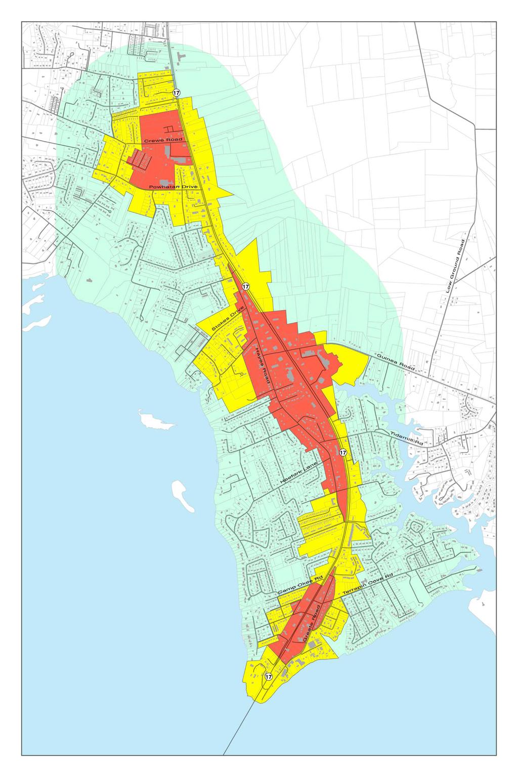
4 suitable for new population growth. These characteristics make both locations excellent candidates for additional planning for the type of growth to achieve the mix of uses, densities, and connectivity envisioned by the County. While this document focuses on the Gloucester Point/Hayes portion of Gloucester as demonstrated on Map 1, future planning efforts will center on achieving this in the Gloucester Courthouse area as well. The most recent planning effort that exclusively focused on the southern portion of Gloucester County took place in the 1990 s. A citizen based effort to consider the future of the area, more closely defined as the Gloucester Point Census Designated Place (CDP), resulted in the Gloucester Point Plan. Many of the concepts discussed in this amendment echo the sentiment of the Gloucester Point Plan, but renew the Plan s vision based on current concerns and community needs. Three main sections within the CDP are identified in this plan as areas that can benefit from additional planning efforts and new implementation tools in order to achieve the village characteristics envisioned by the community: Crewe Road Area, Hayes Road Area, and Greate Road Area. Size Considering Gloucester s residential and commercial growth for the next years involves utilizing Census population data and as well as projections and estimates. The Gloucester Point/Hayes area of the County was this Plan s focus, however, Gloucester Courthouse has long been an area where mixed uses and mixed density fit well and therefore is also being considered as an additional Village Development Area to serve our community. When reviewing the growth projections complied for Gloucester by the Virginia Employment Commission (VEC), a range of acreage was calculated to serve our growth needs countywide. The available vacant lands identified in the Village Development Areas will be able to accommodate the range of anticipated growth over the next 10 to 20 years. Land Use Plan A map, known as the Future Land Use Plan, provides a visual representation of the areas that were studied in the Gloucester Point/Hayes area. Based on the analysis of the growth and land area desired for the Plan, as well as the consideration of the existing land use, this map outlines areas shown as: Core, Transitional, and Conventional. The Core area already contains most of the community s non residential uses such as dining, shopping, and offices. The Transitional area contains some denser residential uses such as duplexes, townhomes and apartments. Single family homes with a few townhomes or condominiums make up the area shown as Conventional, but it remains in close proximity to the Core and Transitional areas. Details about the characteristics of each area shown on the map can be found in Section V. ii

5 Benefits The benefits associated with the study and future implementation of the Gloucester Point/Hayes Village Development Area Plan are wide reaching. They will affect those living and working in this portion of the County, as well as those commuting to other areas along the Route 17 corridor. By providing increased connectivity for local traffic, pedestrians and cyclists, fewer cars will be utilizing Route 17. Local traffic will have more options to satisfy their travel demands and see decreases in travel time. The many transportation benefits are explored in detail in Section VI and Appendix C, however, in addition to transportation, other benefits are realized through implementation of this Plan. These include increased economic viability in commercial areas, neighborhoods that are more walkable and less dangerous for children and other non drivers, more choices for housing options to serve various housing needs, better planned development that emphasizes the community s needs and desires, and other quality of life improvements discussed further in Section VI. Closing This document represents a long term vision based on community feedback as well as the analysis of data. Implementation of this vision will occur over time on an incremental basis, similar to piecing together a puzzle. As with any good planning tool, it is not intended to be static over the next 20 years; instead it will be reviewed and revised when necessary according to the desires of the community. iii
6 Plan I. Background The shape of American towns and cities has changed over time, with a major shift in American planning coming in the late 1940s, when suburbs as we now know them today were developed. These new real estate projects placed new homes outside of existing towns and village centers, where they could only be accessed by car, rather than close to, or within, existing areas where walking or bicycling to destinations was possible. The new suburbs were also largely made up of only one type and style of home, rather than the mix of housing and sizes common in classic villages. New patterns of residential growth separated uses such that homes, shops, offices and, more importantly, jobs, were in different locations and necessitated destination generated driving patterns. This separation of uses was in contrast to the mixed use character of places that relied more on walking, biking and public transportation to reach the local shop or one s job. In recent years, large lot subdivisions, more removed from major transportation corridors and public water and sewer, have been the dominant pattern of residential growth in Gloucester County. While homes on larger lots have certain benefits, the cost of transportation and commuting patterns have had adverse effects over time. In Gloucester County during the 1980 s, five acre lot subdivisions became the standard. As a result more land was consumed and new infrastructure was required to meet the rising population demand. This included new schools, utilities, and increases in number of deputies for public safety. Besides capital demands, this trend created longer commutes between home, work, shopping and leisure activities, all of which generated more traffic, road construction and maintenance to handle the demands of the suburban way of life. As a way to address some of the effects of sprawl and strip development, particularly on traffic and transportation, new legislation was adopted in 2007 as Virginia Section of the Code of Virginia, requiring certain localities experiencing more rapid growth to amend their Comprehensive Plans to incorporate one or more Urban Development Areas or UDAs. A UDA is more closely defined as an area designated by a locality that is appropriate for higher density development due to its proximity to transportation facilities, as well as public water and sewer infrastructure. Based on the language in State Code, UDAs can also be designated for infill or redevelopment. These areas must be sized to meet projected residential and commercial growth in a locality for the next 10 years, but not more than 20 years into the future. In addition, the Code indicates that federal, state and local transportation, utility, economic development, and other public funding should, to the extent possible, be directed to these locations in the County. Minimum densities for housing types and non residential uses are incorporated into the guidance provided from the State. These include: four single family residences per acre, six townhouses per acre, or twelve apartments or condominium units per acre; and a floor area ratio (FAR) of at least 0.4 for commercial development or some combination thereof. In order to achieve these minimum densities features such as those listed below should be incorporated into site design: (i) pedestrian friendly road design 1
7 (ii) (iii) (iv) (v) (vi) (vii) interconnection of new local streets with existing local streets and roads connectivity of road and pedestrian networks preservation of natural areas mixed use neighborhoods, including mixed housing types, with affordable housing to meet the projected family income distributions of future residential growth reduction of front and side yard building setbacks reduction of street widths and turning radii at subdivision intersections This list represents principles associated with Traditional Neighborhood Development (TND), which is also known as New Urbanism. Gloucester already has several projects that incorporate some of these principles into their design. Many were obtained by rezoning the properties in order to make the mix of uses and/or densities obtainable, however, the text in this document provides information on how other properties in the Gloucester Point/Hayes area of the County can develop in a way that represents the community s vision and accommodates years of population and business growth. By doing so, as this growth takes place over time, individual projects can link together in a way that serves those who live, work, and visit the southern portion of Gloucester. II. Location: Why Gloucester Point/Hayes? In Gloucester County, both the central area of the county, known as Gloucester Courthouse, as well as the southern portion around Gloucester Point, demonstrate village characteristics. This is illustrated in the Comprehensive Plan s Future Land Use Plan for the County which designates each of these areas as Village. Both Villages are also located in the Development District. This portion of the County has been established as the area most suitable for new population growth. These characteristics make both locations excellent candidates for additional planning for the type of growth necessary to achieve the mix of uses, densities, and connectivity envisioned by the County. While this document focuses on the Gloucester Point/Hayes portion of Gloucester as demonstrated on map, future planning efforts will center on expanding Traditional Neighborhood Design principles in the Gloucester Courthouse area as well. The most recent planning effort that exclusively focused on the southern portion of Gloucester County took place in the 1990 s. A citizen based effort to consider the future of the area, more closely defined as the Gloucester Point Census Designated Place (CDP), resulted in the Gloucester Point Plan. Map shows the boundaries that were utilized in that planning effort. Many of the concepts discussed in this planning document echo the sentiment of the Gloucester 2
8 Point Plan, but renew the Plan s vision based on current concerns and needs. The work represented on the following pages of this amendment began with the Gloucester Point Plan and further analyzed the area within it. After reviewing existing conditions and listening to concerns from area citizens and businesses, three main sections within the CDP were identified for inclusion in the : Crewe Road Area, Hayes/Guinea Road Area, and Greate Road Area. These areas were selected based on existing conditions such as shopping, dining, parks, schools, water and sewer availability, and transportation connectivity options which allow people to enjoy these amenities in close proximity to their homes without the need to travel by car on Route 17. Each of these areas offers their own unique features, however, they are all well suited for planning and implementation efforts such as those described this document. Through thoughtful decision making and review of new development and redevelopment proposals, the County can retain the existing viability of the community as well as foster opportunities to improve it. In the future, additional sub area planning for these designations or master plans for individual projects can further help the County focus on the specific needs of each segment. Some of the attributes that make Gloucester Point and Hayes the top choice for village scale density and development also represent challenges. While Route 17 serves as an important area of commercial services for local residents, it is also a major regional commuter route with very high traffic volume. Route 17 effectively divides Gloucester Point. Development that successfully connects residents and businesses across Route 17 will be extremely difficult. The type of village scaled development that is associated with Traditional Neighborhood Design, is primarily built around small scale street systems that serve pedestrians and cars at low volumes and speeds, not major arterial highways. For this reason, TND land uses that directly address the street, such as residential uses with small front yards and front porches, shop front retail and service uses, cafes, and small parks, are better suited to narrower and quieter parallel or perpendicular streets than to the immediate Route 17 corridor. A second challenge to new, village scaled development is the existing pattern of development in the Gloucester Point area. The Point is largely made up of auto oriented shopping centers along Route 17, with suburban scaled single family housing behind. The area is largely built out, with only small, scattered sites undeveloped. Because of this pattern, changes to the development character of Gloucester Point, from auto oriented to village like, will only happen over time, with small new developments, infill lot development, and redevelopment of existing sites and structures as they age or no longer meet market demands. Consideration of how to outline the should focus on areas within Gloucester Point where village scaled new development can be centered away from the busy Route 17 corridor; yet remain visible and accessible from the corridor. Areas of existing importance, such as shopping and other activity centers, should be taken into account. Use of signage will be important for assistance in wayfinding. Areas of infill and redevelopment potential should also be identified. Taking these factors into account, staff, consultants, and the UDA steering committee have identified Urban Development Areas as depicted on the following map. This plan establishes core UDA zones areas where the most intense new development should be permitted in the future at three of the most important nodes in the Gloucester Point area. 3
9 o Greate Road: future development along Greate Road has the potential to take advantage of the activity and employment of the Virginia Institute of Marine Science as well as the recreational activity associated with the Gloucester Point Beach and boat ramp. New businesses and residences might cater to this, and surrounding, areas, while taking advantage of an area that is somewhat isolated from the traffic of Route 17. o Hayes Road & Guinea Road: as a major intersection, and a center of existing shopping in the area, this crossroads will continue to be an important center for Gloucester Point. New development at this location can set a village scale, rather than strip shopping center, pattern for a larger area. Central to further development of this area is access to Hayes Road, a long parallel to Route 17 that has not developed in the same automobile centric fashion, and which may represent the area s Main Street in the future. The presence of the Gloucester Point library, a movie theater, post office and several restaurants and retail establishments makes this intersection a prime destination for local activity. o Crewe Road: located at the northern limit of the Gloucester Point/Hayes Village Development Area. With existing shopping options and a public school, as well as several undeveloped sites, new development in this area can add new homes and businesses in a walkable pattern and take advantage of the existing connectivity of the existing road network. By focusing on the Crewe Road frontage, development in this area can avoid Route 17 s traffic, while remaining visible and accessible. At each of these important core areas, this amendment proposes TND development and redevelopment that combines commercial and residential uses in a compact, walkable pattern. These mixed use cores should be surrounded by additional transitional areas, where compact neighborhoods, with some small commercial uses, support the businesses in the core. Beyond these core and transitional areas in the Gloucester Point and Hayes portions of the County, are many established neighborhoods that will contribute to the functional development within the Core and Transitional areas. III. Goals Future development in the Gloucester Point/Hayes area will be guided by this and other sections of the Comprehensive Plan, in addition to the ordinances that are written to support the community s vision. The 1995 Gloucester Point Plan provides additional goals specific to the Gloucester Point area and are a common thread in the current community. Some of these include: Concentrate new development in appropriate locations by encouraging more efficient site design and the sharing of access, parking, and utilities. Authorize higher densities outside the 100 year floodplain where public water and sewer service, open space, and other amenities are incorporated in site design proposals. In cooperation with VDOT, plan for improved pedestrian walkways and bicycle paths within public rights of way whenever possible. The Gloucester Point plan goes on to set future land use goals for this area centered on the idea of a village scale. This plan s suggestion that future development within the Gloucester Point CDP should be 4
10 based on neighborhood and mixed use centers, and feature parks and pedestrian amenities, rather than a continuation of strip commercial development. These goals are very much in line with ones established in conjunction with this Comprehensive Plan amendment. Using the feedback received from the public at the kick off meeting in November 2010 as well as the responses to the survey that nearly 300 area citizens completed, the following goals were established and serve as guidance for the : Engage community members in all phases of planning for the study area in order to incorporate the community s long term vision. A significant amount of outreach was held in conjunction with this planning effort. Community meetings, online/phone surveys, and formation of a steering committee with staff and local stakeholders were a start. Work will continue to keep the community engaged throughout additional steps as well as during implementation elements. Ensure the area is established at a scale that is appropriate based on anticipated population and employment growth. A demographic analysis was performed using the available population and employment numbers provided by the U.S Census Bureau and the Virginia Employment Commission (VEC). These numbers and the associated analysis provide the data necessary to ensure that the area selected meets the needs of our growing community. Preserve and reinvest in established residential neighborhoods. Existing residential neighborhoods help shape the southern portion of Gloucester County. Great care has been taken to ensure that these areas can remain as they are today and also benefit from the potential opportunities being created around them. This includes safer streets and increased pedestrian walkways to current goods and services such as the grocery stores and post offices as well as future amenities such as diverse dining and shopping options. Create efficient transportation options which promote connectivity between internal road and pedestrian networks and reduce dependence on the principle arterial corridor of Route 17. Ensuring that new roads are connecting to existing ones and incorporating pedestrian options will help everyone living, working, and visiting Gloucester Point and Hayes access goods and services and decrease trips on Route 17. 5
11 Provide a safe, functional pedestrian environment to allow non drivers to safely access their destinations within the study area. The must incorporate functional pedestrian options that allow non drivers to access to their destinations such as jobs, doctor s offices, grocery stores, and even the public library. Safe crossings of intersections, especially those incorporating Route 17, are important to allow non drivers to be a vital part of our community. Allow for mixed use and mixed density uses where appropriate. Mixed use development that incorporates some retail or office space with residential space is more consistent with the areas identified on the map as Core areas, while mixed density residential fits in the areas identified as Transitional areas in most cases. However, there should be a review of development proposals in order to review each for suitability with the community s vision and established County guidelines. Retain existing economic vitality and provide for progression of new economic opportunities. Over the years Gloucester Point and Hayes have provided many business options for County residents. The amendment should assist these businesses in preserving and expanding as desired. Increased opportunities for new development and redevelopment should result in improved economic vitality for those existing businesses by attracting more people to the area as a destination as well as capturing more local dollars from those choosing the convenience of shopping locally in a village setting. IV. Land Use Recommendations Earlier in this amendment, the three main portions in Gloucester Point and Hayes were identified as along Greate Road, Hayes/Guinea Road, and Crewe Road. At each of these important focus areas, this amendment proposes TND development and redevelopment that combines commercial and residential uses in a compact, walkable pattern constructed around an analysis of its land use areas and neighborhoods. Incorporating a mix of uses and densities into growth is very different from the separation of these considerations that has been traditionally applied to development in Gloucester. Development that uses principles of TND is set apart from typical suburban construction by its focus on compactness, its mix of land uses, and other features aimed at building meaningful neighborhoods and places rather than subdivisions full of single family detached homes and shopping centers. It is a common suburban development practice to organize land uses into separate areas for commercial use, residential use, etc. well planned TND development is, instead, organized into sections based on intensity of use and activity. For Gloucester, these are identified as the mixed use Core areas as well as Transitional. Mixed use cores should be surrounded by additional transitional areas, where compact neighborhoods, with some small commercial uses, support the businesses in the core. Beyond these core and transitional areas in the Gloucester Point and Hayes portions of the County, are many 6
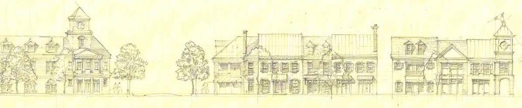
12 established neighborhoods that will contribute to the functional development within the Core and Transitional portions. The Core Area: The Village Center The Village Center is the geographical and functional core or heart of the community. Neighborhood gathering, recreation, shopping, and transportation are all focused on this core area. Traffic patterns for automobiles and pedestrians also radiate from this central location. The Village Center should be seen as the heart of the TND community in much the same way as a Main Street, important crossroads or set of downtown blocks forms the heart of older towns and villages throughout Virginia and elsewhere. While Gloucester Point and Hayes have a great deal of commercial development, this development is almost entirely made up of car oriented strip shopping centers. The community as a whole should have a concentric relationship to the village center, with the densest development located within the village center, town homes and other attached units located nearby and detached homes farther from the center. In keeping with the overall goals for TND development, the village center should incorporate a mix of uses that include commercial, civic, residential, and recreational land uses. Mixed Use The village center is the primary location where commercial uses can be mixed into the community, alongside, or collocated with other land uses. The village center should allow and encourage small retail, service, and office uses, located along walkable streets within the TND core. Commercial and civic uses should be designed to serve the needs of the immediate neighborhood, including dining, as well as serve customers traveling to the village center from other communities. The typical layout of such uses places retail and service uses at the street level, with office or residential uses above. Yards and Setbacks Commercial uses should be located close to or immediately at the edge of the sidewalk. Because the village center is designed with pedestrians in mind, shallow setbacks allow users to access the commercial uses quickly and safely, without crossing large parking lots. This arrangement also creates a sense of enclosure on village center streets that adds to the appearance and vitality of the village center. Within this arrangement, larger setbacks are possible, but should be reserved for certain cases. One such case is for important buildings such as museums, libraries, or other civic spaces where a plaza or other appropriate open space can add importance and interest to the building and surrounding streetscape. In another case, dining establishments can use a deeper setback to include outdoor dining space that will add vitality to the street. In both cases, these deeper setbacks should be used carefully and sparingly, with the overall pattern of the village center in mind. Civic spaces In addition to commercial and residential uses, the village core should include at least one civic space as a community gathering area for residents, or for community events. This civic space may take the form of a landscaped park, hardscaped plaza, or civic building such as a library, church, or government center. Such a civic space can provide an important relief from the density of the town center, and should be placed near the center of the village, or in a place of importance, such as at the termination of a street. 7
13 Parking The village center is intended as a commercial area that caters more to pedestrians than do typical suburban shopping centers. For this reason, parking in the village center should be carefully planned to allow access to village center uses without harming the feel or function of the area. All streets within the village center and within the TND community in general, should include on street parking. When off street parking is necessary, parking lots should be implemented behind buildings. When street front parking cannot be avoided, parking lots should be screened from view with walls, fences, or landscaping. To facilitate these parking arrangements, shared parking strategies, public parking areas, and structured parking should be considered. Flexibility needs to be incorporated into ordinances that typically focus on conventional development that separates uses. Transitional Area The Transitional Area is meant to divide the active and highly commercial Core Area from quieter residential areas. It is as a bridge between the activity and high density of the core, and quieter, less dense residential areas. The Transitional Area will be primarily residential, but made up of more intensive residential uses such as apartments, condominiums, and town homes. The Transitional Area will also include a mix of commercial uses, but at a lower commercial density than in the Core Area. It serves as the ideal location for small shops, restaurants, or offices that primarily serve the residences around them. Development parameters for the Transitional Area should seek to bridge those used in Core and residential areas, including minimums and maximums established for building height, front and side yards, and other parameters. Live Work Units The Transitional Area is a good place to allow live work units, a type of commercial and residential use in one, designed to have a ground floor shop, with an apartment or townhouse on floors above for the shop owner or operator. These units are typically associated with small startup businesses that are ideal for the TND scale and transitional area. Lot Size Residential lots located in the Transitional Area are necessarily smaller than lots in many typical suburban developments. Smaller lots put houses closer to each other, and closer to the village center, in order to preserve walkability in a more compact community. The result is a given number of residential lots occupying less total acreage than with typical suburban construction. The TND community should include a wide variety of lot and house types at a variety of sizes, from small town house lots near the village center, to small single family detached lots, and larger estate lots away from the core. Final lot sizes should be based on careful master planning, as well as market demand for residential uses. Yards and Setbacks In order to achieve density and walkability goals, residences in this type of development are built closer to the street, and closer to each other. Within the narrow, pedestrian oriented streets of a TND, an appropriate residential front yard may be as little as 10 or 15 feet. TND communities also often have a maximum building setback (for example, 20 feet) in order to allow variation, while also maintaining a regular and ordered appearance within the neighborhood. 8
14 Rear garages and parking areas As with parking in the village center, residential parking areas and garages should be established in a way that make vehicle access convenient, but without negatively impacting pedestrian access. In most cases, communities that incorporate TND principles are designed with mid block alleys, allowing access to garages at the rear of residential lots. Other options for front access lots include those that share driveways between two houses, and side yard driveways to access rear lot garages. Lot mix In order to create the type of successful neighborhoods found in many established towns and main streets, projects must maintain a careful balance between housing types and sizes. In typical suburban neighborhoods where only a few (or only one) home type or design is allowed, the result is a sense of sameness seen in many conventional developments. While this mix will necessarily be influenced by market demand, various house types (single family, town home, and condo) and sizes should be mixed together generously to give the TND neighborhood a feeling of originality and variety. Other Land Use Considerations Land uses that may still be important to the overall function of a community should not be completely ruled out when considering the incorporation of the TND principles associated with the Core and Transitional Areas. Certain economic development activities that are not traditionally included may include light manufacturing uses, big box development, or even agriculture at certain scales. While these uses are not traditionally compatible village scale development, they may be incorporated into a larger plan as a thoughtfully planned exception, and should not be excluded outright without careful consideration. Land uses at a proper scale that attract people to the area and generate a sense of community and vitality typically found in a village should be encouraged. Implementation that allows for flexibility of design while still insuring that individual proposals contribute to the overall village concept for that designated area is important to achieving the community s long term vision over time. In addition, properties located outside of the mapped Core and Transitional Areas may be well suited for consideration for mixed use and/or mixed density. As time passes and pieces of this plan are put into place, property owners in these locations outside the current boundaries of the Gloucester Point/Hayes Village Development Area may seek these designations through rezoning applications or ask the County to reflect on including their sites in future planning efforts. In the meantime, these areas should provide for connectivity for bicycle, pedestrian and other transportation modes that would allow for longer distance travel between the village areas identified. 9
15 V. Benefits When planning for development to occur over time as outlined by the community s vision, many benefits are realized by numerous stakeholders. Some are realized in cost savings, such as reduced infrastructure costs for roads and utilities. Other benefits cannot be assigned a dollar amount, such as an increased sense of community, more recreation opportunities, and safer streets for children, seniors, and other non drivers. The following sections try to identify some of the benefits that can be realized by those living, working, and/or visiting the. Quality of Life Quality of life is difficult to measure but is apparent in more ways than one. One overall objective of the is to create roads and neighborhoods that are diversified, aesthetic, and healthful. TND communities might be described as healthy for two principal reasons. First, these places tend to have much greater levels of neighborhood social interaction, with residents experiencing a sense of belonging to a community. In effect, they are more livable. This community vitality promotes the development and serves to attract new residents and businesses, as well as to further promote this pattern for future developments. Second, the individual residents of a TND may see health benefits from walking or bicycling within the community in ways that aren t seen in conventional suburbs due to the safety concerns of walking or cycling where appropriate facilities are not present, or where greater travel distances and high speed traffic discourage anything but automobile travel. The incorporation of safety elements, such as well marked crosswalks across Route 17 at key locations will help unite the currently bisected portions of Gloucester Point and allow people to safely travel to area parks or just visit friends, without the concern of peak traffic and potential congestion. Economic Vitality By expanding the options for commercial uses, vacant buildings will begin to fill and new or redeveloped opportunities for various jobs can be created. Current businesses can thrive even with the newly installed concrete median near the Coleman Bridge with increased access for pedestrians. Increased convenience resulting from easier accessibility of goods and services close to home should generate additional customer loyalty to local businesses. As a sense of community and place grows in an area, local merchants should also benefit from new destination traffic as well as capturing more of the commuting traffic that may choose to stop and shop on this side of the Coleman Bridge rather than traveling across to the Peninsula. Safer Streets The inherently slower speed of locally connected streets, when compared to highways and suburban collector roads means greater safety for drivers and pedestrians alike. With cars slowed to reasonable in town speeds, pedestrians are more easily seen by drivers and have more time to cross streets to reach their destinations. Slower automotive speeds also increase safety for drivers, with damage and injury reduced when collisions do occur. A study by Swift and Associates determined that the safest streets were those built 24 feet wide. Despite this, in years past many residential streets built to VDOT standards require streets to be built at a minimum of 36 feet wide. TND style development and the concept of complete streets enhance safety for all users of public rights of way. Improved Emergency Response Another safety issue presented by sprawling and disconnected suburban streets is their effect on emergency response by fire and rescue services. Sprawling suburbs mean longer distances to travel 10

16 between fire and rescue facilities and some homes, while the disconnected nature of cul de sac streets means traveling indirect routes to answer calls. The proximity and connectivity in more densely developed areas have the potential to shorten emergency response times in more instances. Less Time on the Road Density and mix of uses puts daily shopping, employment, and entertainment needs within much closer proximity to residential areas. This proximity reduces time spent commuting and traveling to purchase goods and services resulting in increased residents free time. Transportation Efficient Land Use Traditional Neighborhood Development within the has the potential to make important changes to the efficiency and effectiveness of the area s existing transportation framework. As it now stands, southern Gloucester has a mix of public and private residential streets, often with ditch sections and no sidewalks. With little pedestrian infrastructure, and with large, isolated commercial land uses that do not support walking, nearly all trips must be by car. In addition, streets have limited connections, meaning most or all trips must use Route 17. Local, as well as commuter traffic, has made Route 17 a busy and congested thoroughfare, carrying over 30,000 trips per day. Encouraging Traditional Neighborhood Development transportation patterns in Gloucester Point and Hayes can offer certain transportation benefits as this area of the County grows, including generating fewer, and shorter, car trips than the current system. The rise of Traditional Neighborhood Development as a planning and land use trend over the past 20 to 30 years is due in part to its many advantages and benefits when compared to conventional suburban planning and development patterns. The benefits of strengthened transportation planning in the Gloucester Point/Hayes Village Development Area can extend to everyone who lives and works there, and also to local government and citizens of the larger region. Many of the benefits of TND streets can be measured in terms of increases in system capacity, greater choices to satisfy travel demands, shorter travel times, construction cost savings, and reduced maintenance. On the other hand, other equally important attributes are linked to less scientific quality of life, aesthetic, and safety factors. Reduced Trip Generation and Internal Capture A well planned TND street network for Gloucester Point/Hayes has a distinct advantage over the continued expansion of suburban transportation patterns. This advantage is the reduction in the overall traffic burden on a locality s regional traffic system as well as the number of vehicle trips that are generated. A main focus of TND communities is their mix of uses that combines residential, civic, institutional, and commercial uses into one project on one site, as opposed to creating an enclave or isolated development modules each serving a different use. A resident of a typical TND community 11
17 would be able to complete certain daily tasks, like grocery shopping, dropping a child off at school, or going out for a meal, without leaving the community. With tighter knit neighborhoods, the vehicle does not need to be used to satisfy each and every trip purpose. In contrast, these same tasks in other parts of the County would require leaving a residential development and driving on an arterial highway or major collector road to a commercial development. Trips by TND residents that are made without leaving the TND are called internal capture. These are trips that are shorter, more accessible, safer, and, in some cases, can be accomplished by walking. When analyzing traffic impacts for new developments, the Virginia Department of Transportation allows for the possibility that up to 15% of all trips by TND residents will be internally captured. This means 15% less traffic placed on existing external roads, which can lead to savings in road widening, turn lanes, and signalization. However, actual case studies comparing TND to conventional suburban projects in Virginia and other states have realized even better rates of internal capture, with 25% or more of trips staying within the TND. This is examined in greater detail Appendix C. In summary, a well planned mix of uses, with residences in closer proximity to employment and shopping needs, has the potential to reduce overall traffic on Gloucester Point s major connectors by significant rates. Increased Transportation System Efficiency The key difference between TND street patterns and those found in conventional suburban developments is the use of an interconnected grid of streets, while most conventional subdivisions use a disconnected pattern of streets with many cul de sacs and several high volume collector roads. The overall effect of the TND grid pattern is to divide neighborhood traffic between many small streets rather than concentrate it on a few large collector roads. In the Gloucester Point/Hayes Village Development Area many streets (public and private) are already in place, however, well planned future development can improve the quality and connectivity of these streets. Traffic analyses employing commonly accepted Highway Capacity Manual calculation methods for these two types of street networks clearly reveal that a compact network of small interconnected streets has more traffic capacity than the same street area combined into large collector streets. Intersections, not travel lanes, control the capacity of a street system, and left hand turning movements represent the critical factor that impacts capacity reduction. The typical TND network reduces the loading of left hand turning movements by distributing traffic to and through a larger number of intersections, allowing the entire system to carry a greater load. The net benefit is the need for fewer travel lanes, fewer traffic signals, and fewer traffic accidents while increasing overall system effectiveness. The overall transportation system capacity of Gloucester Point/Hayes is currently dictated by the capacity of Route 17. By adding alternative and parallel routes, overall system capacity can be increased, and traffic congestion at key points improved. Relationship to Regional Transportation Network An additional positive feature of grid street patterns is the potential for interconnections to adjacent developments. Conventional subdivisions are typically self contained, having a single entrance from a major collector road. The impact of this has been witnessed elsewhere in Gloucester County. Moreover, this is common to many rapidly growing Virginia localities that have experienced increased frontage development pressure on their arterial highways but little in the way of adjoining collector and local street improvements. This means that to visit an adjacent development, a resident would have to drive 12
18 onto the arterial highway or major collector road like Route 17 and then enter the neighboring development. Arterial highways are intended to serve regional traffic patterns, with limited access to private properties, while Route 17 currently serves both regional and local traffic, creating conflicts that are difficult to resolve. In general, regional arterial systems are not designed to function well with high levels of frontage access, but commercial traffic cannot be restricted unless local zoning laws limit access management. Some access management is currently in place, such as the Highway Corridor Overlay District and Virginia Department of Transportation s (VDOT s) regulations that went in to place in 2008 and However, recent actions have proved very limited in truly managing access points, even along Route 17 a principal arterial. This results in increased travel time and trip distance while further diminishing the capacity and function of the existing system. Over time, as arterial traffic increases, the trend is to add lanes to the existing system rather than building another way to access the developed commercial areas, such as recent improvements to widen the southern most stretch of Route 17 in Gloucester Point, and this rarely fixes the problem. Pedestrian and Non Car Trips The density, mix of uses, and connected streets that are key features of TNDs make it possible to navigate new development, and possibly nearby areas, without a car. New residential development should ideally be placed within a walkable distance of new and existing commercial development. While this doesn t mean that cars aren t necessary in these areas, it does mean that certain trips, for shopping, dining out, or visiting neighbors, might be short enough to consider walking or bicycling. Transportation guidelines for areas incorporating principles of TND encourage reduced lateral clearance between the street lanes and street trees and other forms of landscaping, thereby creating a natural, and more attractive form of traffic calming. Further, with a well planned, interconnected street system, pedestrians and cyclists have the option to select safer and quicker routes based on their knowledge of real time traffic conditions in their neighborhoods. Unfortunately, road building in Virginia in years past often fails to emphasize pedestrian improvements, as seen in recent upgrades to Route 17 in Gloucester Point. Having a plan that identifies the community s desire to provide for non automotive modes of transportation will allow for better coordination of transportation funds to insure that the transportation needs of all users are considered. The number of trips made without a car will vary widely depending on the features of village, as well as factors like weather. However, case studies reveal high levels of internal traffic capture, showing that among people shopping and dining in TND commercial areas, as many as 18% had traveled there on foot. This represents an 18% reduction in traffic over single use suburbs where no walking trips are possible due to long distances and unfavorable conditions between residential and commercial areas. The challenge for future transportation improvements in the Gloucester Point/Hayes Village Development Area will be to implement consistent design standards that work in a complementary way to enhance capacity. Additional comprehensive transportation planning studies in and around the Gloucester Point/Hayes portion of the County that focus on opportunities for (a) interconnectivity, (b) intersectional capacity enhancements, (c) upgrade of existing interior streets, and (d) integration of new street systems with existing roads should be considered by the County. 1 These regulations are currently under review based on legislation from the 2011 Session of the Virginia General Assembly. 13
CHAPTER 3 VISION, GOALS, & PLANNING PRINCIPLES. City of Greensburg Comprehensive Plan. Introduction. Vision Statement. Growth Management Goals.
 CHAPTER 3 VISION, GOALS, & PLANNING PRINCIPLES Introduction The Greensburg Comprehensive Plan is intended as a working community document. A combination of long and short-term goals, this document is intended
4.1.3 LAND USE CATEGORIES
 4.1.3 LAND USE CATEGORIES a. City Center District The City Center District incorporates the existing character and mix of uses in downtown Belmont to encourage redevelopment and new development in keeping
Living in Albemarle County s Urban Places
 Living in Albemarle County s Urban Places ALBEMARLE COUNTY, VIRGINIA A Closer Look at Albemarle s Approach to Managing Growth and Creating Quality Urban Environments www.albemarle.org Page 2 Living in
EXISTING COMPREHENSIVE PLAN
 EXISTING COMPREHENSIVE PLAN Town Center Land Use Element: V. LAND USE POLICIES Town Center Mercer Island's business district vision as described in "Your Mercer Island Citizen-Designed Downtown" was an
Policies and Code Intent Sections Related to Town Center
 Policies and Code Intent Sections Related to Town Center The Town Center Vision is scattered throughout the Comprehensive Plan, development code and the 1994 Town Center Plan. What follows are sections
ARTICLE 6: Special and Planned Development Districts
 ARTICLE 6: Special and Planned Development Districts 6-10 Traditional Neighborhood Development (TND) District 6-10.10 Purpose and Intent The Traditional Neighborhood Development (TND) District provides
ARLINGTON COUNTY, VIRGINIA
 ARLINGTON COUNTY, VIRGINIA County Board Agenda Item Meeting October 15, 2005 DATE: September 28, 2005 SUBJECT: Request to Advertise the adoption of the 2005 Clarendon Sector Plan C. M. RECOMMENDATION:
Hockessin Community Redevelopment Plan
 Hockessin Community Redevelopment Plan 3.1 Introduction The Community Redevelopment Plan for the Village of Hockessin is the result of the people s vision for a distinct village center that serves as the
Town Center (part of the Comprehensive Plan)
") Town Center (part of the Comprehensive Plan) Mercer Island Town Center Looking North (2014) In 1994, a year-long process culminated in a set of design guidelines and code requirements for the Town Center
Town Center (part of the Comprehensive Plan) Mercer Island Town Center Looking North (2014) In 1994, a year-long process culminated in a set of design guidelines and code requirements for the Town Center
TRANSIT ORIENTED DEVELOPMENT PINELLAS COUNTY MPO LIVABLE COMMUNITIES INITIATIVE PINELLAS COUNTY COMPREHENSIVE PLAN AMENDMENTS
 PINELLAS COUNTY MPO LIVABLE COMMUNITIES INITIATIVE MODEL LAND DEVELOPMENT CODE TRANSIT ORIENTED DEVELOPMENT PINELLAS COUNTY COMPREHENSIVE PLAN AMENDMENTS MPO Livable Communities Initiative Goal: Improve
Complete Neighbourhood Guidelines Review Tool
 Complete Neighbourhood Guidelines Review Tool Prepared By: City of Regina Planning Department October 2014 Page 1 of 14 Community Development Review Checklist for Secondary Plans and Concept Plans The
Small Area Plan. South Gateway
 Small Area Plan Adopted May 12, 2008 South Gateway Purpose. The South Gateway Small Area Plan defines the City s expectations for the future of the southern entrance to the City at Interstate 85 and Highway
Implementation Guide Comprehensive Plan City of Allen
 Implementation Guide 2030 Comprehensive Plan City of Allen DRAFT 2015 Implementation Guide Allen 2030 Comprehensive Plan INTRODUCTION The Comprehensive Plan serves as a guide for the growth and development
Urban Development Area (UDA) Process in Virginia: History & Requirements
 Process in Virginia: History & Requirements") Urban Development Area (UDA) Process in Virginia: History & Requirements J. Kelli Nash Office of Intermodal Planning and Investment VDOT Coordinating Transportation & Land Use Forum Thursday, June 2, 2016
Urban Development Area (UDA) Process in Virginia: History & Requirements J. Kelli Nash Office of Intermodal Planning and Investment VDOT Coordinating Transportation & Land Use Forum Thursday, June 2, 2016
Access Management: An Overview
 Figures 1-5 Below Evolution of development along a highway. In the early stages, land along the road is used for farming with little traffic generated. As time passes, the highway corridor becomes a de
5.1 Site Plan Guidelines
 5. Community Core Guidelines Development of the Community Core will take place by plan of subdivision and site plan approval. It will occur in a phased manner that will reflect the timing of residential
4. Shape Transitions. 4. Shape Transitions
 4. Shape Transitions 49 Zoning District Policies Overall Intent: Maintain neighborhood character by creating compatible transitions that minimize land use conflicts. Strategy: Define the character of zoning
II. SINGLE FAMILY RESIDENTIAL
 II. SINGLE FAMILY RESIDENTIAL Castle Rock is made up of numerous individually built houses and subdivision tracts that have been developed during the past century. Some of the tracts are diverse in architectural
Citizen Advisory Group Meeting 5: Land Use April 14, 2011
 Citizen Advisory Group Meeting 5: Land Use April 14, 2011 Meeting Agenda 1. Background Review 2. Transportation Follow-up 3. PED Overlay Approach 4. Land Use Mapping 5. Group Exercise 6. Wrap-up and Next
Metro. Activity Center Design Guidelines. Recommendations For Developing Focused, Mixed-Use Commercial/Residential Centers
 Metro Activity Center Design Guidelines Recommendations For Developing Focused, Mixed-Use Commercial/Residential Centers Metro Activity Centers What is a MAC? Legacy, the adopted guide for the future growth
2040 LUP is a part of the Comprehensive Plan and carries the same legal authority. Economic Challenges
 1.1. Guiding Anchorage s Growth Where will new residents settle over the next two decades? Where will people work, shop, and play? Will there be enough room to grow? How will Anchorage look? Will growth
Chapter 4. Linking Land Use with Transportation. Chapter 4
 Chapter 4 Linking Land Use with Transportation Chapter 4 59 Chapter 4 Linking Land Use with Transportation Community Design and Transportation Program Introduction Since the 1950s, the predominant development
What Does It Take To Create A Town Center?
 What Does It Take To Create A Town Center? Context, Design, and Process The Prince Frederick Master Plan Update 1 Background and Overview A Brief History of Town Centers in Calvert County 2 Background
3.1 community vision. 3.3 required plan elements
 Chapter 3 Community Form 3.1 community vision 3.2 Parks & landscaping concepts 3.3 required plan elements D R A F T 20 Community Form Chapter 3 3.0 Community form 3.1 community vision The Specific Plan
CITY OF CHARLOTTESVILLE, VIRGINIA CITY COUNCIL AGENDA
 CITY OF CHARLOTTESVILLE, VIRGINIA CITY COUNCIL AGENDA Agenda Date: December 16, 2013 Action Required: Adoption of Resolution Presenter: Staff Contacts: Title: James E. Tolbert, AICP, Director of NDS James
Silver Line CPAM UPDATE. Transportation and Land Use Committee October 14, 2016
 Silver Line CPAM UPDATE Transportation and Land Use Committee October 14, 2016 Purpose Recap Project History and Map Changes Provide Overview of CPAM Components Discuss Transportation Impacts Discuss Fiscal
C. Westerly Creek Village & The Montview Corridor
 C. Westerly Creek Village & The VISION Community Vision When the goals of the city are achieved Westerly Creek Village, a distinctive community defined by Montview Boulevard and Westerly Creek, is a strong
hermitage town center
 hermitage town center A Community Vision prepared by Strada for The City of Hermitage and The Mercer County Regional Planning Commission January 2007 table of contents introduction 3 design principles
Gloucester County s Comprehensive Plan. The Community Connection
 Gloucester County s Comprehensive Plan The Community Connection Current Comp Plan Adopted in 1991 with a 20 year planning horizon Updated in 1995 with Part V- Implementation Recommendations and Appendix
BROOKHILL NEIGHBORHOOD MODEL ZONING MAP AMENDMENT PREFACE TO APPLICATION
 BROOKHILL NEIGHBORHOOD MODEL ZONING MAP AMENDMENT PREFACE TO APPLICATION June 15, 2015 Revised: August 1, 2016 I. VISION Brookhill is a proposed community based upon the principles of Albemarle County
Land Use Amendment in Southwood (Ward 11) at and Elbow Drive SW, LOC
 at and Elbow Drive SW, LOC") 2018 November 15 Page 1 of 10 EXECUTIVE SUMMARY This land use amendment application was submitted by Rick Balbi Architect on 2017 August 31 on behalf of Sable Developments Ltd, and with authorization from
2018 November 15 Page 1 of 10 EXECUTIVE SUMMARY This land use amendment application was submitted by Rick Balbi Architect on 2017 August 31 on behalf of Sable Developments Ltd, and with authorization from
Midtown Greenway Land Use and Development Plan Executive Summary
 Midtown Greenway Land Use and Development Plan Executive Summary Introduction The Midtown Greenway Land Use and Development Plan sets policy direction for land use and development in the Midtown Greenway
Port Lavaca Future Land Use
 Port Lavaca Future Land Use Introduction The City of Port Lavaca is beginning to see sustained growth, after many years of relative stable population. New single family homes, apartments, and businesses
Executive Summary. NY 7 / NY 2 Corridor
 Executive Summary NY 7 / NY 2 Corridor Transportation and Land Use Study December 2005 Prepared for: Town of Colonie Capital District Transportation Committee Prepared by: Introduction: Land use decisions
V. Vision and Guiding Principles
 V. Vision and Guiding Principles The Master Plan for the Powers Ferry Corridor seeks a foundation in the desires of the community. At times, various elements of the community offered opposing viewpoints,
FORMER CANADIAN FORCES BASE (CFB) ROCKCLIFFE SECONDARY PLAN. Official Plan Amendment XX to the Official Plan for the City of Ottawa
 ROCKCLIFFE SECONDARY PLAN. Official Plan Amendment XX to the Official Plan for the City of Ottawa") FORMER CANADIAN FORCES BASE (CFB) ROCKCLIFFE SECONDARY PLAN Official Plan Amendment XX to the Official Plan for the City of Ottawa 1 INDEX THE STATEMENT OF COMPONENTS PART A THE PREAMBLE PAGE Purpose...
FORMER CANADIAN FORCES BASE (CFB) ROCKCLIFFE SECONDARY PLAN Official Plan Amendment XX to the Official Plan for the City of Ottawa 1 INDEX THE STATEMENT OF COMPONENTS PART A THE PREAMBLE PAGE Purpose...
9 th Street Sub Area Plan
 9 th Street Sub Area Plan In the 1990 s, when the Township prepared the last Master Plan, the 9 th Street corridor was studied as part of a larger 9 th Street Focus Area that included the West Main Street
CITY OF PUYALLUP. Background. Development Services
 CITY OF PUYALLUP Development Services 333 South Meridian Puyallup WA 98371 To: City Council From: Katie Baker, AICP, Planning Division Re: South Hill Neighborhood Plan Adoption Date: (Meeting date: February
Status Update (2006 vs. Now) Citizen s Advisory Committee February Plan for Prosperity
 Citizen s Advisory Committee February Plan for Prosperity") Status Update (2006 vs. Now) Citizen s Advisory Committee February 2018 Plan for Prosperity 2000 2017 2000 2017 Gardnerville Population 6,000 5,760 5746 5,500 5,000 5,067 5,550 5,165 5,394 5,412 5,250
Status Update (2006 vs. Now) Citizen s Advisory Committee February 2018 Plan for Prosperity 2000 2017 2000 2017 Gardnerville Population 6,000 5,760 5746 5,500 5,000 5,067 5,550 5,165 5,394 5,412 5,250
CONTENTS 8.0 LAND USE 8.1 GENERAL LAND USE 8.2 RESIDENTIAL 8.3 MIXED USE 8.4 COMMERCIAL 8.5 EMPLOYMENT LANDS
 8-2 Land Use 8.0 LAND USE CONTENTS 8.1 GENERAL LAND USE 8.1.1 Uses provided for in all Land Use Designations 8.1.2 Uses prohibited in Hazardous Lands, Hazardous Sites and Special Policy Areas 8.1.3 Uses
7Page 91 CLEMMONS COMMUNITY COMPASS 7 COMMUNITY CHARACTER
 7 Community Character The beauty of Clemmons won t necessarily be a reflection of our past, but our future. This quote from Comprehensive Plan Steering Committee member Wayne Dodson captures the essence
COMMUNITY DESIGN. GOAL: Create livable and attractive communities. Intent
 COMMUNITY DESIGN Intent An attractive, well-designed County will attract quality development, instill civic pride, improve the visual character of the community, and create a strong, positive image for
Transportation. Strategies for Action
 Transportation A major priority for the Overlake Neighborhood is to develop a multimodal transportation system. To achieve this system, a balance has to be found among travel, circulation and access needs;
Chapter 6--Urban Design
 6.1 Introduction... 6-1 6.1.1 Background & Scope... 6-1 6.1.2 Relationship to State Law... 6-2 6.1.3 Relationship to Other General Plan Chapters... 6-2 6.2 Guiding Principles... 6-2 6.3 Urban Design Guidelines...
Gold Line Bus Rapid Transit Transit Oriented Development (BRTOD) Helmo Station Area Plan
 Helmo Station Area Plan") Appendix F Gold Line Bus Rapid Transit Transit Oriented Development (BRTOD) Helmo Station Area Plan Introduction and Purpose of the Plan The Gold Line Bus Rapid Transit facility is an eleven-mile dedicated
Appendix F Gold Line Bus Rapid Transit Transit Oriented Development (BRTOD) Helmo Station Area Plan Introduction and Purpose of the Plan The Gold Line Bus Rapid Transit facility is an eleven-mile dedicated
2.0 THE PLATINUM TRIANGLE VISION
 2.0 THE PLATINUM TRIANGLE VISION The envisions an exciting future for the area surrounding Angel Stadium of Anaheim, the Honda Center and The Grove of Anaheim. 2.1 Planning Principles In order to further
Lehigh Acres Land Development Regulations Community Planning Project
 Lehigh Acres Land Development Regulations Planning Effort Summary In July, 2010 Commissioner Frank Mann invited the Lehigh Acres community to start discussing how to achieve their recently adopted community
A. WHAT IS A GENERAL PLAN?
 I. Introduction A. WHAT IS A GENERAL PLAN? A general plan is the planning guideline for the future of a city. It contains goals and policies which regulate urban development, the protection of the natural
The Five Components of the McLoughlin Area Plan
 The Five Components of the McLoughlin Area Plan This documents contains the complete language of the five components of the McLoughlin Area Plan: The Vision Statement The Values The Guiding Principles
The transportation system in a community is an
 7 TRANSPORTATION The transportation system in a community is an important factor contributing to the quality of life of the residents. Without a sound transportation system to bring both goods and patrons
E. RURAL COMMERCIAL/INDUSTRIAL PARK MODEL
 E. RURAL COMMERCIAL/INDUSTRIAL PARK MODEL 1. PURPOSE The purpose of the Rural Commerce/Industrial Park Model is to provide parameters within which a grouping of business buildings with parking, loading
HE VISION. Building a Better Connected Place
 HE VISION Building a Better Connected Place WALK INTO THE FUTURE. Life in Cranberry, 2030 Here s what our residents told us they wanted to see in their community by 2030: The Cranberry of 2030 is a place
MAIN STREET ECONOMIC DEVELOPMENT STRATEGY
 MAIN STREET ECONOMIC DEVELOPMENT STRATEGY A PATHWAY TO A BETTER POUGHKEEPSIE DRAFT Working Paper #2: Planning Strategies Submitted December 1 st, 2015 to the City of Poughkeepsie LAND USE LAW CENTER PACE
ELK GROVE GENERAL PLAN VISION
 2-1 CHAPTER 2: 2-2 CREATING OUR The Community Vision for Elk Grove, expressed through a Vision Statement and a series of Supporting Principles, is a declaration of the kind of community that Elk Grove
GUIDELINES. Transit Oriented Development. Approved by Edmonton City Council on February 15, 2012 in tandem with City Policy C565
 Transit Oriented Development GUIDELINES Prepared by the City of Edmonton Sustainable Development and Transportation Services Departments Approved by Edmonton City Council on February 15, 2012 in tandem
Prosperity Hucks Area Plan. Transportation and Planning Committee May 11, 2015
 Prosperity Hucks Area Plan Transportation and Planning Committee May 11, 2015 Presentation Outline 1. Background and Location 2. Community Dialog Process 3. Activity Center Recommendations 4. Wedge Recommendations
CHAPTER 1. Ms. Guajardo s Class - Central Elementary CH 1 1
 INTRODUCTION CHAPTER 1 Ms. Guajardo s Class - Central Elementary CH 1 1 1.1 SETTING South Centre City is a linear corridor south of Downtown Escondido paralleling Centre City Parkway and South Escondido
Section 9 NEIGHBORHOOD DESIGN
 Section 9 NEIGHBORHOOD DESIGN City of Lancaster Comprehensive Plan D u n k i n, S e f k o & A s s o c i a t e s, I n c. NEIGHBORHOOD DESIGN INTRODUCTION There are many ways in which a neighborhood can
Public input has been an important part of the plan development process.
 Lakewood s Comprehensive Plan recognizes that transportation helps shape the community, and that the way the community provides for the safe and efficient movement of people affects the character of the
Review of Opportunity Area C Draft Comprehensive Plan and Draft BOS Follow-On Motions. Special Working Group Meeting March 4, 2015
 Review of Opportunity Area C Draft Comprehensive Plan and Draft BOS Follow-On Motions Special Working Group Meeting March 4, 2015 The slides that follow identify where the draft Comprehensive Plan has
LAND USE OVERVIEW WHAT YOU WILL FIND IN THIS CHAPTER
 LAND USE WHAT YOU WILL FIND IN THIS CHAPTER Information about the City s expected population and employment growth. Description and capacity of existing and future land use designations. Policies that
Definitions. Average Daily Traffic Demand (ADT): The actual number or projected number of cars that pass a point in a 24-hour period.
: The actual number or projected number of cars that pass a point in a 24-hour period.") Definitions Access Management: A combination of physical techniques and transportation policies used to control the flow of traffic between roads and the surrounding lands. Alternative City Form Scenarios:
Definitions Access Management: A combination of physical techniques and transportation policies used to control the flow of traffic between roads and the surrounding lands. Alternative City Form Scenarios:
Strategic Growth Area #1 Northampton Boulevard Corridor Area
 Strategic Growth Area #1 Northampton Boulevard Corridor Area Description Strategic Growth Area #1 has established itself as a major employment center in Southside Hampton Roads. Opportunities exist to
City of Hermosa Beach Administrative Policy #
 City of Hermosa Beach Administrative Policy # SUBJECT: Living Streets Policy Date: Approved by: City Council Authority: Public Works Department & Community Development Department Mayor, PURPOSE The City
Sahuarita District & Phase 1 Master Plan. Town Council December 11, 2017
 Sahuarita District & Phase 1 Master Plan Town Council December 11, 2017 Visioning Study Visioning Process Advisory Group Meetings Community Questionnaire Town Center Case Studies Community Analysis The
Concord Community Reuse Project Goals and Guiding Principles. Overarching Goals (OG)
") Concord Community Reuse Project Goals and Guiding Principles Overarching Goals (OG) No priority is implied by the order of presentation of the goals and guiding principles. Overarching goals for the Concord
Concord Community Reuse Project Goals and Guiding Principles Overarching Goals (OG) No priority is implied by the order of presentation of the goals and guiding principles. Overarching goals for the Concord
Draft Memorandum #1: Goals and Vision for Revitalization
 Keizer Revitalization Plan Draft Memorandum #1: Goals and Vision for Revitalization Submitted to: City of Keizer April 12, 2018 (revised) Prepared By: Angelo Planning Group and Otak, Inc. Project No. 17482.A
Draft for Public Review. The Market and Octavia Neighborhood Plan
 Draft for Public Review The Market and Octavia Neighborhood Plan San Francisco Planning Department As Part of the Better Neighborhoods Program December 2002 IOverview Why Plan a Better Neighborhood Here
Mark-up of the effect of the proposed Bronte Village Growth Area OPA No.18 on the text of section 24, Bronte Village, of the Livable Oakville Plan
 Mark-up of the effect of the proposed Bronte Village Growth Area OPA No.18 on the text of section 24, Bronte Village, of the Livable Oakville Plan Notes: This document is provided for information purposes
ELMVALE ACRES SHOPPING CENTRE MASTER PLAN
 ELMVALE ACRES SHOPPING CENTRE MASTER PLAN Contents 1.0 INTRODUCTION... 2 2.0 LOCATION... 2 3.0 EXISTING CONTEXT... 2 4.0 VISION & GUIDING PRINCIPLES... 2 5.0 LAND USE AND BUILT FORM... 4 5.1 St. Laurent
Proposed Comprehensive Plan Strategies DRAFT for discussion June 28, 2017
 Proposed Comprehensive Plan Strategies DRAFT for discussion June 28, 2017 Land Use Rural Areas Refine the Farm and Forest area (FF) Update FF boundaries to account for existing lots less than five acres
Ivywild On The Creek PRELIMINARY CREEK DISTRICT MASTER PLAN
 Ivywild On The Creek PRELIMINARY CREEK DISTRICT MASTER PLAN Introduction: Rejuvenating an extraordinary Creekside neighborhood THE CREEKSIDE DISTRICT The Ivywild On The Creek Neighborhood District Master
The University District envisions, in its neighborhood
 Envisioning the University District Link Light Rail in Seattle s neighborhoods CIY OF SEALE CONCEP-LEVEL SAION AREA PLANNING RECOMMENDAION RESOLUION # 30165 EXHIBI L Vision 08.2000 he University District
The Illinois Department of Transportation and Lake County Division of Transportation. Route 173, including the Millburn Bypass
 The Illinois Department of Transportation and Lake County Division of Transportation welcome you to this Public Hearing for U.S. Route 45 from Illinois Route 132 to Illinois Route 173, including the Millburn
WHAT WE HEARD REPORT - Summary Bonnie Doon Mall Redevelopment Application (LDA )
") WHAT WE HEARD REPORT - Summary Bonnie Doon Mall Redevelopment Application (LDA18-0184) PROJECT ADDRESS: 1 Bonnie Doon Shopping Centre NW, 8420 85 Street NW & 8715 85 Street NW PROJECT DESCRIPTION: Rezoning
WHAT WE HEARD REPORT - Summary Bonnie Doon Mall Redevelopment Application (LDA18-0184) PROJECT ADDRESS: 1 Bonnie Doon Shopping Centre NW, 8420 85 Street NW & 8715 85 Street NW PROJECT DESCRIPTION: Rezoning
1.0 Purpose of a Secondary Plan for the Masonville Transit Village
 Report to Planning and Environment Committee To: Chair and Members Planning & Environment Committee From: John M. Fleming Managing Director, Planning and City Planner Subject: Masonville Transit Village
[PLANNING RATIONALE] For Site Plan Control and Lifting of Holding Zone By-Law 101 Champagne Avenue. May 23, 2014
![[PLANNING RATIONALE] For Site Plan Control and Lifting of Holding Zone By-Law 101 Champagne Avenue. May 23, 2014](/thumbs/75/71599615.jpg "[PLANNING RATIONALE] For Site Plan Control and Lifting of Holding Zone By-Law 101 Champagne Avenue. May 23, 2014") [PLANNING RATIONALE] For Site Plan Control and Lifting of Holding Zone By-Law 101 Champagne Avenue May 23, 2014 Contents 1.0 Introduction... 2 2.0 Site Context... 2 2.1 Adjacent Uses... 2 Figure 1: Site
[PLANNING RATIONALE] For Site Plan Control and Lifting of Holding Zone By-Law 101 Champagne Avenue May 23, 2014 Contents 1.0 Introduction... 2 2.0 Site Context... 2 2.1 Adjacent Uses... 2 Figure 1: Site
CHAPTER 7: VISION AND ACTION STATEMENTS. Noble 2025 Vision Statement
 CHAPTER 7: VISION AND ACTION STATEMENTS This chapter presents the vision, policy and action statements that transform the comprehensive planning study, an analysis of Noble s past, future trends and community
DRAFT. 10% Common Open Space
 % OF CHARLOTTE IS CATEGORIZED AS A. LAND USES : Placeholder map displaying location of Place Type GOALS: Accommodate XX% of future growth. Provide a concentration of primarily commercial and civic activity
Community Design Guidelines. Port Wallace DRAFT
 Community Design Guidelines Port Wallace DRAFT Energy 1 2 3 Nature Movement Connections Built Form DRAFT Layout Energy 1 Nature Community Design Guidelines GREAT COMMUNITIES PROTECT, CELEBRATE, AND CONSERVE
Chapter 2: Vision, Goals and Strategies
 Chapter 2: Vision, Goals and Lake Elmo Today & Tomorrow Comprehensive Plan 2040 2 VISION, GOALS & STRATEGIES - DRAFT 4-6-2018 INTRODUCTION Comprehensive Plan Purpose Perhapse the most important objective
Northern Territory Compact Urban Growth Policy
 Northern Territory Compact Urban Growth Policy A Reference Policy Document to clause 2.7 (Reference to Policy) of the NT Planning Scheme May 2015 Table of Contents 1 Policy Setting... 3 1.1 Context for
Westwind Developments Ltd. PIONEER LANDS AREA STRUCTURE PLAN - PROPOSED AMENDMENT
 FEBRUARY 2013 TABLE OF CONTENTS 1.0 BACKGROUND... 1 1.1 Amendment... 1 2.0 LOCATION & CONTEXT... 2 2.1 Land Ownership... 2 3.0 POLICY CONTEXT... 3 3.1 Municipal Development Plan... 3 3.2 Capital Region
PILLAR FOUR INTEGRATE LAND USE & TRANSPORTATION
 PILLAR FOUR INTEGRATE LAND USE & TRANSPORTATION 8 Scarborough Centre on the Move Transportation Master Plan 123 8 Transportation Pillar Four Integrate Land Use & The fourth pillar focuses on the relationship
4 January 11, 2012 Public Hearing APPLICANT:
 . 4 January 11, 2012 Public Hearing APPLICANT: MID-ATLANTIC AUTO PROPERTY OWNER: DZR, LLC STAFF PLANNER: Leslie Bonilla REQUEST: Conditional Use Permit (truck rental, automobile service, and automotive/bulk
TOD 101 CREATING LIVABLE COMMUNITIES WITH TRANSIT
 1 CREATING LIVABLE COMMUNITIES WITH TRANSIT What are transit Centered Communities? Benefits of Partnerships to Support and Implement What You Will Learn Portland s Pearl District Your Trainers Today Catherine
ROAD CLOSURE AND LAND USE AMENDMENT SILVER SPRINGS (WARD 1) NORTHEAST OF NOSEHILL DRIVE NW AND SILVER SPRINGS ROAD NW BYLAWS 2C2018 AND 29D2018
 NORTHEAST OF NOSEHILL DRIVE NW AND SILVER SPRINGS ROAD NW BYLAWS 2C2018 AND 29D2018") Page 1 of 19 EXECUTIVE SUMMARY This application proposes redesignating two parcels in the community of Silver Springs from Special Purpose Future Urban Development (S-FUD) District and undesignated road
Page 1 of 19 EXECUTIVE SUMMARY This application proposes redesignating two parcels in the community of Silver Springs from Special Purpose Future Urban Development (S-FUD) District and undesignated road
Downtown North Las Vegas Demonstration Site Project. Project Update
 Downtown North Las Vegas Demonstration Site Project Project Update 7.16.14 Presentation Overview Project Purpose and Process Planning Context Opportunities and Barriers Summary Community Input Preliminary
Neighborhood Districts
 NEIGHBORHOOD DISTRICTS SEVEN MAIN DISTRICTS Neighborhood Districts While the Development Plan provides a broad-scale overview of the neighborhood, this section focuses on uses and relationships at the
, C-MS I June 3, 2016 $1500 pd chk #216918
 , C-MS-8 LOTS 21 THROUGH 40, INCLUSIVE, BLOCK 299 CLEMENTS ADDITION TO THE CITY OF DENVER SOUTHEAST QUARTER OF SECTION 34, TOWNSHIP 3 SOUTH, RANGE 68 WEST, SIXTH PRINCIPAL MERIDIAN, CITY
Welcome to the Oakridge Centre Open House
 Welcome to the Oakridge Centre Open House Why is the City hosting this event? This open house is to inform you of a rezoning application submitted to the City of Vancouver to amend the existing CD-1 (Comprehensive
Plano Tomorrow Vision and Policies
 Plano Tomorrow Vision and Policies PLANO TOMORROW PILLARS The Built Environment The Social Environment The Natural Environment The Economic Environment Land Use and Urban Design Transportation Housing
FUTURE DEVELOPMENT AREAS
 FUTURE DEVELOPMENT AREAS Refer to the Future Development Map on Page 2. Suburban Residential (Less than 3 units/acre) Suburban Residential neighborhoods form the backbone of Smyrna. While growth and redevelopment
Urban Planning and Land Use
 Urban Planning and Land Use 701 North 7 th Street, Room 423 Phone: (913) 573-5750 Kansas City, Kansas 66101 Fax: (913) 573-5796 Email: planninginfo@wycokck.org www.wycokck.org/planning To: From: City Planning
URBAN DESIGN BRIEF. 2136&2148 Trafalgar Road. Town of Oakville
 URBAN DESIGN BRIEF 2136&2148 Trafalgar Road Town of Oakville Prepared By: METROPOLITAN CONSULTING INC For 2500674 Ontario Inc November 2016 TABLE OF CONTENTS Page No. 1.0 Introduction/Description of Subject
Sheridan Boulevard S TAT I O N A R E A P L A N S H E R I D A N B O U L E VA R D S TAT I O N A R E A P L A N
 Sheridan Boulevard S TAT I O N A R E A P L A N 1 City of Lakewood Adopted November, 2006 S H E R I D A N B O U L E VA R D S TAT I O N A R E A P L A N The Vision The City of Lakewood s overall vision is
Civic Center District
 Civic Center District The Civic Center district is the civic and social heart of Warrenville, containing such public buildings as the City Hall, Warrenville Public Library, Police Station, Park District
PINE CURVE REZONING. Property does not meet criteria for open space preservation and is not a candidate for a park
 PINE CURVE REZONING BACKGROUND Purchased as two parcels in 2001 and 2002 Annexed and Zoned Greater Downtown District Historic Center September 25, 2002 and October 7, 2002 WHAT THE PROJECT IS AND IS NOT
CHAPTER 7: Transportation, Mobility and Circulation
 AGLE AREA COMMUNITY Plan CHAPTER 7 CHAPTER 7: Transportation, Mobility and Circulation Transportation, Mobility and Circulation The purpose of the Transportation, Mobility and Circulation Chapter is to
URBAN DESIGN BRIEF URBAN DESIGN BRIEF 721 FRANKLIN BLVD, CAMBRIDGE August 2018
 URBAN DESIGN BRIEF URBAN DESIGN BRIEF 721 FRANKLIN BLVD, CAMBRIDGE August 2018 DESIGN BRIEF CONTENTS PART A 1.0 INTRODUCTION 2.0 DESCRIPTION & ANALYSIS OF SITE CONTEXT 3.0 DESIGN CONSTRAINTS AND OPPORTUNITIES