32. Strandhill Mini-Plan
|
|
|
- Annabelle Garrison
- 6 years ago
- Views:
Transcription
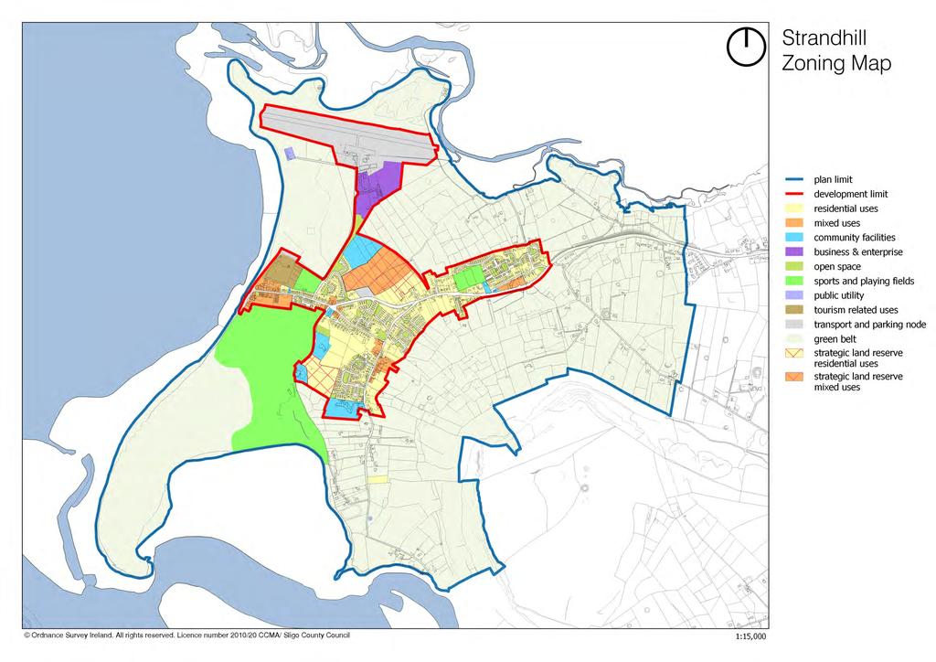
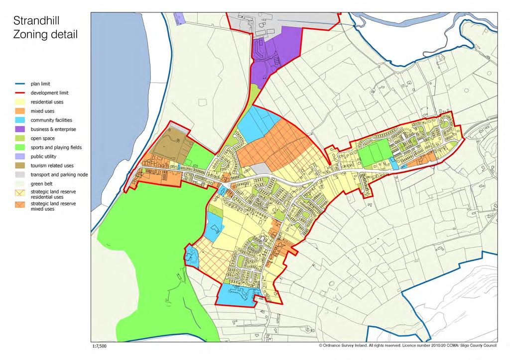
1 32. Strandhill Mini-Plan Village profile Strandhill is located 8 km to the west of Sligo city, on the western extremity of the Coolera Peninsula. The village extends along the north-western foothills of Knocknarea mountain and is surrounded on three sides by coastline Cummeen Strand to the north, Sligo Bay to the west and Ballysadare Bay to the south. In the County settlement hierarchy (see Section 3.2 of the CDP), Strandhill is designated as a Gateway Satellite and is acknowledged as a settlement with special functions (i.e. tourism). The village is characterised by linear roadside development within the serviced area and ribbon development on the unserviced fringes. In recent years, consolidation of the built-up area did occur to a certain degree, with residential estates filling in some gaps and developing part of the backlands. Population and housing According to Census information, the village had a population of 1,413 persons in 2006 (an increase of 41% from 2002), and a population of 1,596 persons in 2011 (an increase of 13% from 2006). Census 2016 recorded a population of 1,753 persons in Strandhill. Strandhill has seen significant growth during the Celtic Tiger years, with at least 201 new housing units constructed from 2004 to 2011, most of this occurring before Much of the residential development took the form of suburban-type estates with some road frontage and backland development. A small number of apartments have been built so far. A further 51 apartments have been permitted since 2004 but were not constructed. Given the tourism function of Strandhill, a relatively high seasonal vacancy rate would be expected. Data from the Census 2011 (taken in April 2011) indicated 185 vacancies out of a total of 773 residential units inside the plan area. The Council s 2015 survey revealed 35 vacant buildings (not including apartments) in the village. Planning permissions are still in place for another 150 residential units. Accordingly, there is no need for additional residential lands during the Plan period. Community facilities The community facilities present in the village comprise a national school, a catholic church, playing pitches, tennis courts and changing facilities operated by Strand Celtic Football Club on the Airport Road. A Church of Ireland church with a small graveyard is located at Scarden on the outskirts of the village. Strandhill Golf Club includes an eighteen-hole links course, practice facilities and a substantial clubhouse. The Rugby Club, located on the R-292 at Larass, has three pitches. 1
2 The village lacks a community centre/sports centre. The resident and future population clearly need a community centre as well as other facilities. This aspiration is supported in the Mini-Plan and a suitable site has been reserved for this purpose. Commercial and enterprise development The Enterprise and Technology Centre, which opened in 2002, offers 1,450 sq.m. of office and enterprise space and is currently fully occupied. There is demand for additional enterprise space. Strandhill s main employment generator is its tourism industry, created in part by its reputation as one of the top surfing destinations in Ireland. This is visible in the village in the form of surf schools and surf lodges/accommodation. Tourism accommodation in the village includes a 4-star, 22-room hotel on the Top Road (southern end of R-292 as it passes through the village), a caravan and camping park on the sea front, an 11-bedroom hotel and holiday apartments also on the Top Road. Permission was granted for a tourist facility comprising a 13-bedroom hotel, a 6- unit apart-hotel along with a leisure and fitness centre located on the Top Road. None of these structures was built. Infrastructure Strandhill is well served by the R-292 and the road network between the village and Sligo City. In recent years, substantial improvements have been carried out to the village streets. Strandhill s drinking water comes from a reservoir at Grange East townland, Knocknahur, which is supplied from Cairns Hill Water Treatment Plant. The capacity of this plant (between 5,000m 3 and 8,000m 3 a day) currently exceeds demand. The sewage treatment plant at Killaspugbrone with a design capacity of 1,500 PE, was estimated in 2016 to incur a load of over 2,900 PE. Irish Water s Capital Investment Plan includes a proposal to upgrade the plant to 3,700 PE. Sligo Airport, located between the village and the sea, is seen as an important element of the Gateway s connective infrastructure. The County Development Plan explicitly supports improved access to the Airport with a view to enhancing Sligo s accessibility for tourists and businesses. The Airport no longer functions as a public commuter/tourist airport, but it continues to accommodate the North West base of the Irish Coast Guard s Search & Rescue Helicopter, as well as occasional corporate, passenger and cargo flights. There is potential for the Airport to resume regular services in the future. Archaeological heritage The Strandhill area has a particularly rich archaeological heritage. The Coolera or Cúil Irra Peninsula was one of the major cultural and ritual centres of Neolithic Ireland (circa BC) and Knocknarea played an important role as a ritual focal point. Today, this is evidenced by a large concentration of passage tombs, an enclosure and a hut site complex on the mountain. The peninsula retained its importance during later prehistory and early medieval times. The Giant s Grave court tomb on the road to the Airport and the kitchen middens in the townlands of 2
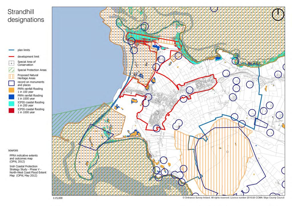
3 Culleenamore and Culleenduff are also indicators of substantial activity from the Neolithic period onwards. One of Strandhill s archaeological gems is the ecclesiastical site at Killaspugbrone, which includes a ruined medieval church and a graveyard used by the local community in modern times. An extensive area of Knocknarea mountain and a wedge of land to the south-west of the golf course in Carrowdough have been designated as zones of archaeological potential (ZAPs). The lower slopes of Knocknarea are intrinsic to its archaeological amenity and unspoilt views of the mountain are of immense heritage value. Natural heritage Uniquely positioned at the coast, Strandhill is surrounded by some of Sligo s most valuable natural heritage sites. These sites are protected by European and national legislation, as they support a diversity of natural and semi-natural habitats and a wide range of flora and fauna. The following areas are protected under the EU Habitats Directive (92/43/EEC) and EU Birds Directive (79/409/EEC): Ballysadare Bay SAC (site code ); Ballysadare Bay SPA (site code ). Cummeen Strand/Drumcliff Bay SAC (site code ); Cummeen Strand SPA (site code ), Designated sites do not represent the full extent of Strandhill s natural heritage. The wider countryside also makes a valuable contribution to the overall coherence of the ecological network. Thus, the rural hinterland of the village is home to various landscape features, which contribute significantly to local biodiversity. Such features include hedgerows, ditches and banks, stone dykes and walls, linear tree belts (shelter belts), semi-natural or ancient woodlands, plantations, estates, heathlands, green roads and ponds. These provide important habitats, buffer areas and wildlife corridors, which are of major importance for fauna and flora. Coastal erosion One of the more significant issues facing Strandhill is the issue of coastal erosion. The coastline surrounding the village is particularly volatile and dynamic, as evidenced by significant variations in sand levels and beach movements. The extensive beach undergoes considerable change when storms sweep away sand rapidly. The sand often returns slowly to the shore in more stable conditions. In the last three decades, there has been a recorded increase in the frequency of storms affecting the north-western coast of Ireland, compared to the previous half-century. Coastal flooding predictions prepared by the Office of Public Works (OPW) assume a 500-mm increase in sea level by Both factors combine to indicate likely exacerbated erosion of low-lying and soft shorelines, such as the Strandhill peninsula. 3
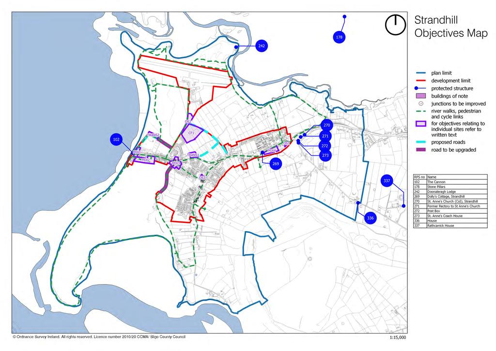
4 The beach and big dune area south of the beach car park were particularly affected by erosion in 2011 and Extensive works had been carried out in 2002, including the construction of a new slipway and promenade extension and the provision of 300 m of rock armour along the beachfront. Storms in 2011 caused extensive damage to a 70-m section of sand dune as well as damage to the end of the walkway to the south of the village. An integrated coastal management strategy is required to address necessary coastal protection works, recreational use of both the dune systems and landward dune grassland, the impacts of proposed infrastructure developments and the sustainable use and management of the existing coastal edge. Objectives Note: These objectives must be considered in conjunction with the policies and objectives contained in Volume 1 and the general policies for mini-plans contained in Chapter 1 of Volume 2 of this Plan. It is an objective of Sligo County Council to: 32.1 Landscape, natural heritage, open space A. Maintain and enhance the conservation value of the Natura 2000 sites surrounding the village. Ensure that Appropriate Assessment Screening is carried out for any plan or project within the Mini- Plan area with potential to impact on Ballysadare Bay SAC (site code ), Cummeen Strand/Drumcliff Bay SAC (site code ), Cummeen Strand SPA (site code ) and Ballysadare Bay SPA (site code ). B. Prepare, in consultation with the DHPCLG, a management plan for the Council-owned lands at Killaspugbrone. C. Apply the precautionary principle in relation to development proposals with potential to impact on the County Biodiversity Site within the buffer zone by requiring an ecological impact assessment to ensure that any proposed development will not affect the integrity and conservation value of the site. D. Have regard to the need to protect existing views of Ballysadare Bay, Sligo Bay, Cummeen Strand and Knocknarea when assessing all new development proposals. E. Encourage landowners in the green belt to manage their land in a sustainable manner by protecting heritage features and landscape character. The retention of stone walls, banks, hedges and trees on townland boundaries is a particular priority. The green belt shall remain principally in lowintensity agricultural use. F. Require all new and replacement agricultural structures to be designed in such manner that they do not interfere with the character of the landscape, whilst ensuring the protection of designated sites. G. Protect the archaeological integrity of all national monuments within the plan area and ensure that development in the vicinity of these areas is strictly controlled. H. Preserve the following views (designated Scenic Routes in the CDP ): i. views of Sligo Harbour, Sligo Bay and Ben Bulben from the R292 at Larass, immediately north of St Anne s Church and Rectory; 4
5 ii. views of Knocknarea from the R-292 at Larass, between St Anne s Church and Sligo Rugby Club; iii. views of Sligo Bay, Ballysadare Bay and Knocknarea from the R-292 at Carrowdough and Culleenamore, between the southern development limit of the village and the Plan limit at Rockview House; iv. views of Sligo Bay and Knocknarea from the Ransboro Local Road L-3503 at Larass, between St Anne s Church and the eastern Plan limit close to Lecarrow and Rathcarrick townland boundaries; v. views of Knocknarea from the Airport Road (L-35052) between the southern boundary of the Business and Enterprise Park and northern boundary of Community zoned lands. I. Provide for a number of incidental public open spaces, notably: i. the Sligo entrance to the village, between the new and old R-292, where a floral or shrub display might be developed, possibly in conjunction with a piece of public art (location marked OS1 on Objectives Map); ii. a strip of land to the east of the Airport Road, which would lend itself to a tree and shrub belt for amenity and shelter purposes (location marked OS-2 on Objectives Map). J. Require any development on the site of Seaview House on Upper Buenos Ayres Drive to retain and landscape a substantial element of open space at the eastern end of the existing garden (location marked OS-3 on Objectives Map) Coastal protection A. Prepare an integrated coastal management plan for Strandhill in consultation with relevant agencies and interested parties. This plan should address, inter alia, the existing and potential recreational uses of the area. The coastal management plan will ensure the protection of Natura 2000 sites through the Appropriate Assessment process. B. Generally maintain a natural buffer along the Atlantic shoreline for a distance landwards of the High Water Mark in the order of 80 m outside the development limit. C. Retain a natural storm berm and dune buffer zone on the west side of the Strandhill caravan park, in the interests of safety. The natural buffer shall be at least 50 metres in width, as measured from the fore-dune ridge, and shall be maintained free from all new permanent structural development. D. Maintain and review dune management, to include, where necessary, appropriate fencing, boardwalks and public information boards in consultation with the National Parks and Wildlife Service of the DAHG. 5
6 32.3 Built heritage and streetscape A. Ensure that the design of new developments along the Top Road (R-292) reflect the scale, character and finishes of existing vernacular buildings at this location. B. Require any development proposal involving the Buildings of Note, identified on the Objectives Map (and their sites), to restore or renovate and/or incorporate these buildings into new development proposals, in a sensitive manner that will contribute to the preservation of the streetscape character. C. Seek the protection and conservation of the following Protected Structures: RPS-102 RPS-242 RPS-269 RPS-270 RPS-271 RPS-272 RPS-273 RPS-336 The Canon, Carrowbunnaun Doonagleragh Lodge, Killaspugbrone Dolly s Cottage, Larass St Anne s Church (Church of Ireland), Larass Former Rectory, Larass Post box, Larass St. Anne s Coach House, Larass House, Rathcarrick D. Prepare a conservation report for Killaspugbrone Medieval Church and Graveyard, in partnership with the community, to inform future conservation works to the Church and graveyard, as resources allow Mixed-use zones A. Require the inclusion of residential units within the mixed-uses zones, subject to medium-high densities and suitable building scale, design and layout that create a strong urban identity. Along new mixed-use streets, terraced buildings are preferred. Civic spaces such as small squares are desirable, as they are conducive to human interaction and safe movement for pedestrians and those with special mobility needs. B. Discourage piecemeal, haphazard development and ensure the assembly and consolidated development of lands within the mixed-use zones on the basis of integrated design proposals/masterplans with appropriate pedestrian/cycle/vehicular links. Prospective developers shall have regard to the DECLG s Guidelines for Planning Authorities Sustainable Development in Urban Areas (Cities, Towns and Villages) and to the DoT/DECLG s Design Manual for Urban Roads and Streets (DMURS 2013) Promenade (location marked MIX-1 on the Objectives Map) C. Encourage the upgrading of existing properties fronting onto the Promenade via appropriate design improvements and/or redevelopment. D. Encourage the redevelopment of the Promenade Corner on the sea front (marked MIX-1 on the Objectives Map) currently comprising shops, dwellings and a public open space, subject to any 6
7 necessary coastal protection measures whilst ensuring the protection of designated sites through screening for Appropriate Assessment at project level. E. Require that any development proposed on the promenade site MIX-1 adheres to the following criteria: i. all new build and redevelopment should be of high quality in terms of design and materials, recognising its importance for the streetscape at the gateway to the promenade area; ii. up to three storeys may be permitted, subject to satisfactory integration with adjoining developments; iii. new development should incorporate an appropriate mix of tourism, commercial and residential uses, combined with adequate backland access and parking provision. Buenos Aires Drive (locations marked MIX-2 and MIX-3 on the Objectives Map) F. Permit terraced buildings up to three storeys in the mixed-use zone along Buenos Aires Drive, subject to appropriate feathering and the creation of a strong building line extending towards the Promenade. G. Require that any development proposal on village centre site MIX-2 (existing Council car park) incorporates the following: i. a pedestrian civic square, capable of being used for events and local markets; ii. iii. pedestrian and possibly vehicular linkages to the Promenade to the west, behind existing development; the location of any car parking behind the building line. In recognition of the scale, and strategic location of the Council car park, the only mixed use development permitted on this site will be the enhancement of the present car parking facility, a community centre and the provision of other recreational facilities. Terraced buildings up to three storeys shall be permitted, subject to appropriate feathering, to integrate with adjoining developments, from the council car park to the existing promenade & in the existing promenade area. The community centre courtyard shall be designed to a high standard in a manner capable of enhancing the streetscape and complementing the existing village. However, any developments within the car park itself shall be restricted to two storeys. H. Encourage any proposal which involves a change of use or redevelopment of an existing property at MIX-3 (next to the existing mini-mart), to include the upgrading of the building façade to reflect its position in the new neighbourhood centre. Mixed-use site on the R-292 (location marked MIX-4 on the Objectives Map) I. Require that any development proposal on the site MIX- 4 (lands to the south-west of the petrol/service station, between the old and the realigned R-292) incorporates the following: i. protection and enhancement of the setting of Dolly s Cottage through appropriate scale and design of all proposed structures; 7
8 ii. where appropriate, new buildings should be dual aspect, with façades fronting both public roads. Their design shall reflect a common theme and be appropriately detailed for such a high-profile site Transport, circulation and parking A. Reserve land for a New Airport Road linking the R-292 to the existing Airport Road (R-277) whilst ensuring the protection of designated sites through screening for Appropriate Assessment at project level. B. Reserve land for the creation of New Burma Road, i.e. a new road linking the lower half of Burma Road with the proposed New Airport Road. C. Extend the Promenade in a northerly direction and link up with the existing Airport Road as indicated on the Objectives Map, to include for the upgrading of the existing lane from the caravan park to the Airport Road whilst taking full account of the need to protect the natural and cultural heritage of the coast and the need to avoid significant adverse impacts on Natura 2000 Sites and on species protected by law. All necessary coastal protection measures should be incorporated into such a project. This extension should be developed in a similar fashion to the existing Promenade whilst also preserving as much as possible of the seafront area as a public amenity. The extension shall be subject to Habitats Directive Assessment. D. Provide public footpaths and public lighting throughout the village as resources permit, and in particular as sites become redeveloped, especially along the Top Road. E. Upgrade the Golf Club Road as resources permit and as developments occur. F. Require all new developments to specifically provide for the needs of persons with special mobility needs (i.e. wheelchairs, prams, visual impairment etc.) G. Improve, as resources permit, the flow of traffic on the existing Promenade. H. Reserve land along Burma Road for a public transport node to include car and cycle parking facilities, bus stop etc (location marked TRANS-1 on the Objectives Map). I. Improve the following junctions: i. the junction between the R-292 and Upper Buenos Ayres Drive; ii. the junction between the R-292 and the Burma Road. 8
9 32.6 Community facilities County Development Plan A. Support the improvement and further development of the existing sports facilities adjoining the Airport Road. B. Require any development proposed on the greenfield site CF-1 (refer to the Objectives Map) to ensure the protection of adjoining designated natural heritage sites. Any proposed development should provide a range of facilities such as a citizens advice point, social services, tourist information, skate park and indoor sports. A youth centre and childcare facilities may be provided within the same building or in a separate structure. C. Assess applications for developments on or adjacent to site CF-1 (refer to the Objectives Map) in accordance with The Planning System and Flood Risk Management Guidelines (Nov 2009, DoECLG & OPW). Development proposals in this area may be required to be accompanied by a site specific Flood Risk Assessment appropriate to the type and scale of the development being proposed. D. Support the improvement and further development of Strandhill Golf Course subject to compliance with the requirements of the EU Habitats Directive Tourism development A. Promote the development of tourism related-infrastructure and facilities within the village in order to increase visitor numbers and to create more local employment. B. Provide a public parking and picnic area to the north of the caravan park, in conjunction with the new road (See Section 33.5), subject to the implementation of a Coastal Management Plan (Section 33.2 A) and a Management Plan for the Council lands at Killaspugbrone (Section 33.1 B). This area will be located adjacent to the existing caravan park entrance, from where two-way traffic movements will operate (location marked TRANS-2 on the Objectives Map). In addition, adequate provision will be made for alternative circulation arrangements within the caravan park. C. Maintain existing trails and establish further looped recreational trails around the village, subject to Habitats Directive Assessment. The routes may include: (1) Beachfront - Killaspugbrone Dorrins Strand Dolly s Cottage Upper Strandhill; (2) Beachfront Maeve s Cairn, Knocknarea Dolly s Cottage Upper Strandhill; (3) Beachfront Portcurry Point Culleenamore/Golf Course Carrowdough Upper Strandhill. All of the above should be signposted as resources permit. Refer to the Objectives Map for the indicative routes of these trails. D. Provide appropriate pedestrian access along the R-292 from Carrowdough to the village in support of trail no. 3 above, whilst retaining all existing stone walls, significant trees and hedgerows. 9
10 32.8 Business and enterprise A. Improve and enhance existing business, enterprise and industrial development within Strandhill by providing essential infrastructure and supporting the provision of high-speed telecommunications. B. Support the continued operation of Sligo Airport. The foreseeable demand for airport-related uses can be adequately met on the lands between the runway and the existing Business and Enterprise Park. C. Protect existing flight paths, i.e. declared distances (published runway length) and runway end safety areas, as requested by the North West Airport Company Ltd. Due regard will be had to airport safeguarding requirements when development proposals in the locality are being assessed. Applications requiring external lighting or floodlighting shall include details of lighting schemes, which will be expected to demonstrate that: i. the lighting scheme proposed is the minimum required to undertake the task; ii. there will be no dazzling or distraction of pilots landing aircraft on the nearby runway Wastewater treatment A. Facilitate the upgrading of the wastewater treatment plant at Killaspugbrone to cater for increased capacity, whilst ensuring the protection of adjoining designated natural heritage sites. 10


11 Buildings of Note BoN No. 1 Eight-bay, two-storey former hotel Architecturally valuable features - roof pitch; chimneys on ridge of roof; - vertical-emphasis windows; This building occupies an important position in the streetscape of Strandhill and retains many traditional architectural features. Recommendation: The character of this building could be enhanced by reinstating the fenestration type appropriate to their time, i.e. timber sash windows. BoN No. 2 Three-bay, two-storey house Architecturally valuable features - roof pitch; chimneys on ridge of roof; - vertical-emphasis windows and window surrounds; - quoins. This building retains many traditional architectural features. Recommendation: The character of this building could be enhanced by reinstating the fenestration type appropriate to its time, i.e. timber sash windows. 11


12 BoN No. 3 and 4 Pair of four-bay and three-bay, two-storey houses Architecturally valuable features - roof pitch; chimneys on ridge of roof; - vertical-emphasis windows; part of a terrace. This building forms part of an important terrace, which reflects the origins of the village of Strandhill. Recommendation: The character of these buildings could be enhanced by reinstating the fenestration type appropriate to their time, i.e. timber sash windows. BoN No. 5 Four-bay, two-storey house Architecturally valuable features - roof pitch; chimneys on ridge of roof; - vertical-emphasis windows This building retains its traditional proportions and is a strong component of this important terrace. Recommendation: The character of this building could be enhanced by reinstating the fenestration type appropriate to its time, i.e. timber sash windows. BoN No. 6 Seven-bay, two-storey terrace Architecturally valuable features - roof pitch; chimneys on ridge of roof; - vertical-emphasis windows. This building forms part of an important terrace, which reflects the origins of the village of Strandhill. Recommendation: The character of this terrace could be enhanced by reinstating the fenestration type appropriate to its time, i.e. timber sash windows, and by removing the fake shutters. 12


13 BoN No. 7 Five-bay, two-storey house Architecturally valuable features - roof pitch; chimneys on ridge of roof; - vertical-emphasis windows. This building occupies an important position in the streetscape of Strandhill and retains its traditional proportions and character. Recommendation: The character of this building could be enhanced by reinstating the fenestration type appropriate to their time, i.e. timber sash windows. BoN No. 8 Four-bay, two-storey public house Architecturally valuable features - roof pitch; chimneys on ridge of roof; - vertical-emphasis windows. This building adds character and a sense of place to the village. Recommendation: The character of this building could be enhanced by reinstating the fenestration type appropriate to its time, i.e. timber sash windows. BoN No. 9 Three-bay, two-storey house Architecturally valuable features - roof pitch; chimneys on ridge of roof; - vertical-emphasis windows; bay windows; - front boundary wall and pedestrian gate. This building adds character and a sense of place to the village. Recommendation: The character of this building could be enhanced by reinstating the fenestration type appropriate to its time, i.e. timber sash windows. 13
14
15
16
17
18
County Development Plan Consolidated Draft + Adopted Amendments August 2017 Volume 2, Chapter 22 Easky Mini-Plan
 22. Easky Mini-Plan Village profile Easky is a coastal settlement located approximately 40 km to the west of Sligo City, in a designated Rural Area In Need of Regeneration. The nearby coastline is designated
6. Ballintogher Mini-Plan
 County Development Plan 2017-2023 Consolidated Draft + Adopted Amendments August 2017 Volume 2, Chapter 6 Ballintogher Mini-Plan 6. Ballintogher Mini-Plan Village profile Ballintogher is located approximately
17. Coolaney-Rockfield Mini-Plan
 County Development Plan 2017-2023 Consolidated Draft + Adopted Amendments - August 2017 17. Coolaney-Rockfield Mini-Plan Village profile Coolaney is located approximately 23 km to the south-west of Sligo
30. Riverstown Mini-Plan
 County Development Plan 2017-2023 Consolidated Draft + Adopted Amendments August 2017 Volume 2, Chapter 30 Riverstown Mini-Plan 30. Riverstown Mini-Plan Village profile Riverstown is located approximately
20. Ballysadare Mini-Plan
 20. Ballysadare Mini-Plan 20. Ballysadare Mini-Plan Community facilities Ballysadare has a wide range of community facilities: a primary school, St Mary s College (secondary school), a health centre, playing
28. Coolaney-Rockfield Mini-Plan
 28. Coolaney-Rockfield Mini-Plan 28. Coolaney-Rockfield Mini-Plan Community facilities Community facilities in Coolaney-Rockfield consist of a primary school, crèche, community centre, sports field and
16. Collooney Mini-Plan
 16. Collooney Mini-Plan Village profile Collooney is located approximately 13 km to the south of Sligo City, in a designated Rural Area under Urban Influence. The village provides a range of services for
35. Gorteen Mini-Plan
 35. Gorteen Mini-Plan 35. Gorteen Mini-Plan Community facilities Community facilities in Gorteen consist of a crèche, community centre, sports field, church, burial ground and health centre. The former
Schedule of Planning Applications Committee Date: 23 May Reference: 06/17/0726/F Parish: Hemsby Officer: Mr J Beck Expiry Date:
 Schedule of Planning Applications Committee Date: 23 May 2018 Reference: 06/17/0726/F Parish: Hemsby Officer: Mr J Beck Expiry Date: 22-05-2018 Applicant: Proposal: Site: Mr Gillett Change of use to the
WELCOME. Land North of STEVENAGE. We would like to thank you for attending our public exhibition today.
 WELCOME We would like to thank you for attending our public exhibition today. The purpose of this event is to share our proposals and hear your thoughts on our ideas. Members of the project team are on
BORRISOKANE SETTLEMENT PLAN
 BORRISOKANE SETTLEMENT PLAN 1.0 General Introduction and Development Context Location Borrisokane is located 15km north of Nenagh on the N52. While the town is primarily residential, it acts as a market
elbridge Core Strategy
 C elbridge Core Strategy Celbridge is designated as a Moderate Growth Town in the RPGs. The County Development Plan reinforces this designation in its settlement strategy. Moderate Growth Towns within
Overview Report. Proposed Development
 Overview Report Proposed Development the construction of a 1km cycle/pedestrian trail including a new footbridge, new car park and entrance road at Drumshanbo Lock and a new pedestrian/cycle road crossing,
I615. Westgate Precinct
 I615. Westgate Precinct I615.1. Precinct Description The Westgate Precinct is located approximately 18km west of the Auckland city centre. There are seven Sub-precincts in the Westgate Precinct: Sub-precinct
CLOUGHJORDAN SETTLEMENT PLAN
 CLOUGHJORDAN SETTLEMENT PLAN 1.0 General Introduction and Development Context Location The market town of Cloughjordan lies close to the border with Offaly at the junction of the R490 and R491 Regional
SPG 1. * the northern and western sections which are open fields used for pasture and grazing;
 SPG 1 1.0 INTRODUCTION This development brief is based on the allocation of the Priors Hall site for employment and countryside recreational purposes in the Corby Borough Local Plan. The brief is intended
8.0 Design and Form of Development 43/
 42/ 8.0 Design and Form of Development 43/ Rothwells Farm, Golborne/ Development Statement Figure 7. Site Constraints Key 44/ Site Boundary 360 Bus Route/Stops Existing Trees Underground Water Pipe Sensitive
Neighbourhood Planning Local Green Spaces
 Neighbourhood Planning Local Green Spaces Introduction... 2 1. Why green space is important... 4 2. Neighbourhood plans and green space... 6 3. Evidence... 8 Statutory designations... 9 Green space audit...
Drrumconrratth Wrriitttten Sttattementt. Position in Settlement Hierarchy Village - Local centre for services and local enterprise development
 Drrumconrratth Wrriitttten Sttattementt Settlement Drumconrath Position in Settlement Hierarchy Village - Local centre for services and local enterprise development Position in Retail Strategy Level 4
Proposed modifications to the proposed variation of the Westport Town & Environs Development Plan August 2011
 Proposed modifications to the proposed variation of the Westport Town & Environs Development Plan 2010-2016 August 2011 Westport Town Council Comhairle an Bhaile Cathair na Mart Mayo County Council Comhairle
Rathmolyon Written Statement
 Settlement Rathmolyon Position in Settlement Hierarchy Village - Local centre for services and local enterprise development Position in Retail Strategy Fourth tier retail centre Population (2011) Census
3.1 The hybrid planning application proposes the following description of development:
 CHAPTER 3: PROPOSED DEVELOPMENT 3.1 The hybrid planning application proposes the following description of development: Hybrid (part-outline/part-full) planning application for a single composite development
6 Site Framework Strategies
 6 Site Framework Strategies 6.1 Introduction Section 6 identifies a number of specific areas which are considered to be key sites within the Plan area and which may have potential for development / redevelopment.
Ratthcaiirrn Wrriitttten Sttattementt
 Ratthcaiirrn Wrriitttten Sttattementt Settlement Rathcairn Position in Settlement Hierarchy Village Serve a smaller rural catchment; provide local services with some smaller scale rural enterprises in
About 10% of the Borough's population lives in the seven rural parishes. Population figures from the 1991 census are given below:-
 8. THE DISTRICT VILLAGES 8.1 Population About 10% of the Borough's population lives in the seven rural parishes. Population figures from the 1991 census are given below:- Village No. of Persons Cottingham
STATEMENT OF OBJECTION TO THE PROPOSED DEVELOPMENT OF LAND AT CHURCH CLIFF DRIVE FILEY
 STATEMENT OF OBJECTION TO THE PROPOSED DEVELOPMENT OF LAND AT CHURCH CLIFF DRIVE FILEY You will be aware that Scarborough borough council have adopted a new local plan that includes land at Church Cliff
Glossary of Terms. 430 Kildare County Development Plan Kildare County Development Plan
 Glossary of Terms 430 431 Glossary of Terms Appropriate Assessment A requirement to consider the possible nature conservation implications of any plan or project on the Natura 2000 site network before
Rochford District Council Allocations Development Plan Document: Discussion and Consultation Document Sustainability Appraisal
 Option SWH1 Balanced Communities Option SWH1 1 To ensure the delivery of high quality sustainable communities where people want to live and work Will it ensure the phasing of infrastructure, including
Chapter 2: OUTLINE PLANNING APPLICATION PROPOSALS. A New Garden Neighbourhood Matford Barton 17
 Chapter 2: OUTLINE PLANNING APPLICATION PROPOSALS A New Garden Neighbourhood Matford Barton 17 2.1. SUMMARY AND STATUS OF THE PROPOSALS 2.1.1. The parameter plans and associated wording in this chapter
Croftamie has a limited range of services and facilities and has close links with neighbouring Drymen.
 CROFTAMIE Croftamie has a limited range of services and facilities and has close links with neighbouring Drymen. Sense of Place Croftamie is a small rural village characterised by a linear low density
ALLERTHORPE NEIGHBOURHOOD PLAN
 Allerthorpe s Neighbourhood Plan sets out a vision for the Parish for the next 15 years (2018 2033) that builds on and reflects the opinions and views of parish residents. VISION In 2033 Allerthorpe will
Woodbrook - Shanganagh
 Section 4: Key Sites Framework Strategy Woodbrook - Shanganagh Local Area Plan 2017-2023 4. Site Framework Strategies The Master Plans shall have regard to the thematic objectives under the LAP Development
PLANNING COMMITTEE DATE: 07/09/2015 REPORT OF THE SENIOR MANAGER PLANNING AND ENVIRONMENT SERVICE CAERNARFON. Number: 4
 Number: 4 Application Number: C15/0034/37/LL Date Registered: 21/05/2015 Application Type: Full - Planning Community: Llanaelhaearn Ward: Llanaelhaearn Proposal: Location: Summary of the Recommendation:
GREENBANK DEVELOPMENT MASTERPLAN
 DEVELOPMENT MASTERPLAN POTENTIAL TRAIN STATION COMMUNITY CENTRE Greenbank will be a connected masterplanned community providing easy access to local and surrounding amenity. Affordable quality homes, green
3.0 Area-Wide Strategies 30
 3.0 Area-Wide Strategies 30 3.6 Tourism Strategy This section of the plan aims to develop and improve the tourism potential of the area. Strategic Context The City Plan outlines the potential of Cork to
Welcome to our exhibition
 Welcome to our exhibition The Homes & Communities Agency (HCA) welcomes you to this public exhibition explaining our proposals for the redevelopment of the former Lea Castle Hospital site. About the Homes
A VISION FOR BLAIRGOWRIE
 Welcome to the Westpark Partnership and Lidl UK GmbH Community Presentation. The purpose of this presentation is for you to view and comment upon the revised and updated proposals for the allocated development
Ballivor Written Statement
 Settlement Ballivor Position in Settlement Hierarchy Village - Local centre for services and local enterprise development Position in Retail Strategy Fourth tier retail centre Population (2011) Census
CORK County Development Plan 2003
 3 VOLUME 3 Specific Zoning Main Settlements Zoning Main Settlements Contents of Volume 3 Settlement 1: BALLINCOLLIG TEXT MAP Settlement 2: BANDON TEXT MAP Settlement 3: BANTRY TEXT MAP Volume 1: Overall
Welcome to our public exhibition
 About our scheme Welcome to our public exhibition Taylor Wimpey East Anglia intends to submit a detailed planning application for a new residential development of 39 high-quality homes at the B&M Concrete
Droitwich Spa 6. Reasoned Justification
 87 Droitwich Spa 6 Reasoned Justification 6.1 Droitwich Spa is identified in the settlement hierarchy (Policy SWDP1) as a main town being the largest settlement in Wychavon District with an estimated population
Clonard Written Statement
 Settlement Clonard Position in Settlement Hierarchy Village - Local centre for services and local enterprise development Position in Retail Strategy Fourth tier retail centre Population (2011) Census 339
Ipswich Issues and Options for the Ipswich Local Plan Review, August 2017, Public Consultation
 Ipswich Issues and Options for the Ipswich Local Plan Review, August 2017, Public Consultation Having reviewed the issues and options documents, the Society has made the following response: Part 1 Strategic
RURAL ZONE - POLICY. Rural Zone Policy. Issue: Rural Environment. Ruapehu District Plan Page 1 of 8
 Rural Zone Policy RU2 RURAL ZONE - POLICY RU2.1 Introduction The natural resources of the rural environment in the Ruapehu District provide the basis for the existing and potential character, intensity
Colchester Northern Gateway Master Plan Vision Review Draft. July 2016
 Colchester Northern Gateway Master Plan Vision Review Draft July 2016 Contents Introduction 4 Context 8 Purpose of the Report 8 Strategic Position 9 Overview of the Process 11 2012 Master Plan Vision 12
Neighbourhood Planning Guidance Local Green Spaces
 Neighbourhood Planning Guidance Local Green Spaces Introduction This guidance note has been produced for communities preparing neighbourhood plans in North Dorset to help them to identify, assess and designate
Derry City and Strabane District Council Planning Committee Report
 Derry City and Strabane District Council Planning Committee Report COMMITTEE DATE: 23 rd March 2016 APPLICATION No: APPLICATION TYPE: PROPOSAL: LOCATION: APPLICANT: LA11/2015/0395/F Residential Development
PORT WHITBY COMMUNITY
 PORT WHITBY COMMUNITY SECONDARY PLAN UPDATE COMMUNITY IMPROVEMENT PLAN URBAN DESIGN GUIDELINES September 2015 DRAFT PROPOSED AMENDMENT NUMBER # to the Whitby Official Plan PURPOSE: The intent of this Amendment
SOUTH EAST LINCOLNSHIRE LOCAL PLAN: HOUSING PAPER DONINGTON (JUNE 2016)
") SOUTH EAST LINCOLNSHIRE LOCAL PLAN: HOUSING PAPER DONINGTON (JUNE 2016) 1 DONINGTON S PLACE IN THE SPATIAL STRATEGY 1.1 Policy 2 of the South East Lincolnshire Local Plan 2011-2036 Draft for Public Consultation
SOUTH EAST LINCOLNSHIRE LOCAL PLAN: HOUSING PAPER DONINGTON (JUNE 2016) 1 DONINGTON S PLACE IN THE SPATIAL STRATEGY 1.1 Policy 2 of the South East Lincolnshire Local Plan 2011-2036 Draft for Public Consultation
Kibworth Harcourt. Introduction. Introduction
 Introduction Introduction Welcome to this public exhibition on the proposals for the delivery of new homes on land at The Kibworths. The purpose of today s exhibition is to give you the opportunity to
Tāhuhu whakaruruhau ā-taone The sheltering ridge pole
 B2. Tāhuhu whakaruruhau ā-taone - Urban growth and form B2.1. Issues Tāhuhu whakaruruhau ā-taone The sheltering ridge pole Auckland s growing population increases demand for housing, employment, business,
The Proposed Auckland Unitary Plan (notified 30 September 2013)
") 3 Business zones Introduction There are 10 business zones in the Unitary Plan: City Centre Metropolitan Centre Town Centre Local Centre Neighbourhood Centre Mixed Use General Business Business Park Light
3 Business zones Introduction There are 10 business zones in the Unitary Plan: City Centre Metropolitan Centre Town Centre Local Centre Neighbourhood Centre Mixed Use General Business Business Park Light
7.1.6 The main components of the development strategy for Hertford are as follows:
 Chapter 7 Hertford 2 Chapter 7 Hertford 7.1 Introduction 7.1.1 The County town of Hertford lies at the confluence of four rivers in a valley setting, which in the past has influenced its shape and form.
5 PLANNING ANALYSIS 5.1 THE SITE AND ITS DEVELOPMENT CONTEXT
 5 PLANNING ANALYSIS 5.1 THE SITE AND ITS DEVELOPMENT CONTEXT The Azuri IRS River Villa Complex site is situated on the western margin of Azuri Phase 1, inland. The whole site borders Rivière du Rempart
2A District-wide Policies
 2A Introduction This Chapter contains policies which are relevant to subdivision, use and development activities occurring across all zones and areas of the District. The policies in this Chapter implement
Page 1 of 19 URBAN DESIGN FRAMEWORK FOR BOLTON STREET WATERFORD
 Page 1 of 19 URBAN DESIGN FRAMEWORK FOR BOLTON STREET WATERFORD 1.0 Introduction: The relocation of the City Council stores and depot from Bolton Street creates an exciting opportunity for development
Kildalkey Written Statement
 Settlement Kildalkey Position in Settlement Hierarchy Village - Local centre for services and local enterprise development Position in Retail Strategy Fourth tier retail centre Population (2011) Census
Land at Rampton Road. Cottenham
 Land at Rampton Road Cottenham Introduction TEP is preparing an outline planning application for 54 dwellings on 6.9 hectares of land adjacent to Rampton Road, Cottenham on behalf of the owners Cambridgeshire
REMARKABLES PARK ZONE
 .10 Remarkables Park Zone.10.1 Resources, Activities and Values The Remarkables Park Area comprises approximately 150 hectares of perimeter urban land in the vicinity of Frankton and occupies a strategic
DESIGN & ACCESS STATEMENT
 DESIGN & ACCESS STATEMENT January 2016 Contents Introduction section 1 Section 1 - Introduction Section 2 - Assessment Section 3 - Involvement Section 4 - Evaluation Section 5 - Design Section 6 - Layout
Appendix 1 Structure plan guidelines
 Appendix 1 Structure plan guidelines This appendix forms part of the regional policy statement [rps]. 1.1. Introduction Structure plans are an important method for establishing the pattern of land use
BLACKHEATH SQUASH CLUB Blackheath Sports Club, Rectory Field, Charlton Road, London, SE7 7EY. Planning, Design and Access Statement
 Planning, Design and Access Statement Revised: 28 th Jan 2016 Peter Pendleton & Associates Ltd Introduction Planning permission will be sought for a refurbishment of existing courts and extension to provide
Newcourt Masterplan. November Exeter Local Development Framework
 Newcourt Masterplan November 2010 Exeter Local Development Framework Background The Exeter Core Strategy Proposed Submission sets out the vision, objectives and strategy for the development of Exeter up
DUNSFOLD NEIGHBOURHOOD PLAN Site Selection Policies
 DUNSFOLD NEIGHBOURHOOD PLAN Site Selection Policies The criteria for assessing sites for future housing and business development in Dunsfold are set out below. (Development criteria, covering what it is
Draft Ada Street Cardiff Area Plan
 Draft Ada Street Cardiff Area Plan (Draft Amendment to Lake Macquarie Development Control Plan 2014) Exhibition: The draft Area Plan is on public exhibition from 29 February 2016 to 29 March 2016. Submissions:
I539. Smales 2 Precinct
 I539. Smales 2 Precinct I539.1. Precinct Description The Smales 2 Precinct applies to a 4.8 hectare block of land located on the southern side of Northcote Road and fronting Lake Pupuke, Takapuna. The
University Park, Worcester Non Technical Summary December 2011
 University Park, Worcester Non Technical Summary December 2011 Introduction UW Wrenbridge LLP, a Joint Venture Company of the University of Worcester and Wrenbridge Land Ltd (the Applicants ) intend to
22.15 OUTDOOR ADVERTISING SIGNAGE POLICY
 22.15 OUTDOOR ADVERTISING SIGNAGE POLICY This policy applies to all land where a planning permit is required to construct or display a sign under the provisions of the Kingston Planning Scheme. 22.15-1
Easkey. Strandhill Dromore West Ransboro Enniscrone. Tourlestraun. Aclare
 Chapter 12. MAPS Mullaghmore Mullaghmore Cliffony Grange Carney Drumcliff Rathcormack Rosses Point Ballincar Easkey SLIGO Strandhill Dromore West Ransboro Enniscrone Ballysadare Ballintogher Collooney
WELCOME GYPSY LANE. Wider Site Location plan. Proposals for the development of LAND OFF FOXLYDIATE LANE WEBHEATH. Proposals for the development of
 WELCOME The developers are preparing an outline planning application for a residential led development and need the community s views in order to develop the proposals further WHAT IS PROPOSED? A high
LONGDEN VILLAGE DEVELOPMENT STATEMENT
 LONGDEN VILLAGE DEVELOPMENT STATEMENT 2017-2027 1 Longden Development Statement 2017-2027 15/01/18 1. Background 1.1 Longden Village Longden village is a very rural and traditional community first mentioned
Former Panshanger Aerodrome, Welwyn Garden City Masterplan Scenarios. Mariposa Investments
 Former Panshanger Aerodrome, Welwyn Garden City Masterplan Scenarios Mariposa Investments Contents 1.0 Introduction 1 2.0 The Site and Surroundings 2 3.0 Local Area Context 6 4.0 Site Features 10 5.0 Development
WELCOME. North East Haverhill. The Planning Process
 WELCOME North East The site to the North East of, known as Great Wilsey Park, is identified by St Edmundsbury Borough Council in its Core Strategy as capable of delivering a Sustainable Urban Extension.
MATURE SUBURBS RESIDENTIAL DEVELOPMENT GUIDELINES
 MATURE SUBURBS RESIDENTIAL DEVELOPMENT GUIDELINES DRAFT FEBRUARY 2005 BIRMINGHAM CITY COUNCIL 1 Introduction Mature Suburbs Residential Development Guidelines - Interim Supplementary Planning Advice -
Parish of Repton NEIGHBOURHOOD DEVELOPMENT PLAN
 Parish of Repton NEIGHBOURHOOD DEVELOPMENT PLAN BASIC CONDITIONS STATEMENT December 2018 CEF 4 Legal Requirements This statement has been produced by the NDP Working Group on behalf of Repton Parish Council
INTRODUCTION. Land south of Bishopswood Lane, Tadley
 0 INTRODUCTION THE SITE Introduction Gladman Developments Ltd. has successfully invested in communities throughout the UK over the past 0 years, developing high quality and sustainable residential, commercial
Public Consultation. Land at Monks Farm, North Grove. Welcome
 Welcome Welcome to our public exhibition for development on Land at Monks Farm, orth Grove. Gallagher Estates and Gleeson Strategic Land are preparing an outline planning application for new homes, open
Crossakiel Written Statement
 Crrossssakiiell Wrriittten tt Sttattementt Settlement Crossakiel Position in Settlement Hierarchy Village - Local centre for services and local enterprise development Position in Retail Strategy Third
MOUNT AVENUE MASTERPLAN WORKING DRAFT NOVEMBER 2006
 MOUNT AVENUE MASTERPLAN WORKING DRAFT NOVEMBER 2006 1 1. OVERALL MASTERPLAN IDENTITY: Dun Dealgan motte and bailey The Dun Dealgan motte and bailey, a national monument, is located to the north east of
Welcome. Land adjacent Sandy Lane WALTHAM CHASE THE PROPOSED SITE
 Land adjacent Sandy Lane WALTHAM CHASE Existing Linden Homes developments Welcome Welcome to Linden Homes Southern s ( Linden ) public exhibition about its proposals for a range of high-quality homes for
Welcome to our public exhibition
 About our development Welcome to our public exhibition This exhibition gives you the chance to view and comment on our proposals for a new residential development of 165 high-quality homes, along with
PLANNING DECISION NOTICE
 PLANNING DECISION NOTICE TOWN AND COUNTRY PLANNING ACT, 1990 Applicant WILLITON VILLAGE HALL STEERING COMM. C/O ALISON CALLOWWAY 54 NORTHCROFT WILLITON TAUNTON TA4 4RT Date Registered 11/08/2006 Application
The proposals presented in September drew a large number of comments and feedback and have been grouped together as follows:
 Appendix A Stakeholder presentation + powerpoint slides Planning Context and Emerging Proposals presentation Nick Tyrrell, Alder King, Planning Consultants Alder King began by setting the site context
Derry City and Strabane District Council Planning Committee Report
 Derry City and Strabane District Council Planning Committee Report COMMITTEE DATE: 20.12.2017 APPLICATION No: APPLICATION TYPE: PROPOSAL: LOCATION: APPLICANT: AGENT: A/2014/0495/F Full Construction of
PART AOTEA PRECINCT
 CONTENTS... PAGE AOTEA PRECINCT...4 14.5.1 INTRODUCTION...4 14.5.2 RESOURCE MANAGEMENT ISSUES...4 14.5.3 RESOURCE MANAGEMENT OBJECTIVES AND POLICIES... 4 14.5.4 RESOURCE MANAGEMENT STRATEGY...5 14.5.5
Chapter 5 Urban Design and Public Realm
 5.1 Introduction Public realm is all areas of the urban fabric to which the public have access. It is where physical interaction takes place between people. It therefore, includes buildings and their design,
Plan Modification to Chapter B2 of the Auckland Unitary Plan(AUP) Operative in part (15 November 2016)
 Operative in part (15 November 2016)") UNITARY PLAN UPDATE REQUEST MEMORANDUM TO FROM Phill Reid Linley Wilkinson DATE 25 September 2018 SUBJECT Plan Modification to Chapter B2 of the Auckland Unitary Plan(AUP) Operative in part (15 November
UNITARY PLAN UPDATE REQUEST MEMORANDUM TO FROM Phill Reid Linley Wilkinson DATE 25 September 2018 SUBJECT Plan Modification to Chapter B2 of the Auckland Unitary Plan(AUP) Operative in part (15 November
Proposed Amendment to the
 Proposed Amendment to the Carrigaline Electoral Area Local Area Plan Amendment No 1: Carrigaline (T-02, O-02 & U-02) August 2012 Proposed Amendment to the Carriagline Electoral Area Local Area Plan 2011
Welcome to our public exhibition
 About Our Scheme Welcome to our public exhibition This exhibition gives you the chance to view and comment upon our emerging proposals for a new residential development of 68 new homes on the site of the
3. Neighbourhood Plans and Strategic Environmental Assessment
 1. Introduction This report sets out a draft Screening Determination for the Preston Parish Council s Neighbourhood Plan and has been prepared by rth Hertfordshire District Council. The purpose of the
HAYLE NEIGHBOURHOOD PLAN FUTURE HOUSING EXPANSION VISION DOCUMENT. Prepared for Hayle Neighbourhood Plan Steering Group by AECOM
 HAYLE NEIGHBOURHOOD PLAN FUTURE HOUSING EXPANSION VISION DOCUMENT Prepared for Hayle Neighbourhood Plan Steering Group by AECOM December 2015 1. Introduction Context Hayle is a linear town situated in
Municipal Development Plan. Summer Village of ROCHON SANDS. Bylaw #241-18
 Municipal Development Plan Summer Village of ROCHON SANDS Bylaw #241-18 TABLE OF CONTENTS PART ONE: BACKGROUND AND PURPOSE 3 SECTION 1: BACKGROUND 3 SECTION 2: GOALS AND POLICIES 3 PART TWO: PHYSICAL ENVIRONMENT
4.3 Dudley Area Plan. Introduction. History and Existing Character. Desired Future Character for Dudley
 4.3 Dudley Area Plan Introduction The suburb of Dudley has developed as a result of various circumstances including its topography, history and mineral resources. Dudley development has been identified
Carnaross Written Statement
 Ca n rrnarrossss W t rriittten Sttattementt Settlement Position in Settlement Hierarchy Position in Retail Strategy Population (2011) Geodirectory (No census data available) Committed Housing Units (Not
CA//17/02777/FUL. Scale 1:1,250. Planning Services Canterbury City Council Military Road Canterbury Kent CT1 1YW
 O CA//17/02777/FUL Scale 1:1,250 Map Dated: 15/03/2018 Planning Services Canterbury City Council Military Road Canterbury Kent CT1 1YW AGENDA ITEM NO 16 PLANNING COMMITTEE APPLICATION NUMBER: SITE LOCATION:
Northern Territory Compact Urban Growth Policy
 Northern Territory Compact Urban Growth Policy A Reference Policy Document to clause 2.7 (Reference to Policy) of the NT Planning Scheme May 2015 Table of Contents 1 Policy Setting... 3 1.1 Context for
CENTRAL BEDFORDSHIRE COMMITTED TO WORKING TOGETHER WITH LOCAL COMMUNITIES
 WELCOME Thank you for coming to our consultation event to find out more about our emerging proposals for Hayfield Park, a residential development jointly promoted by the Hayfield Consortium: Martin Grant
Contents of Part 6. Part 6 Zones
 Contents of Part 6 Part 6 Zones... 6-1 6.1 Preliminary... 6-1 6.2 Zone codes... 6-3 6.2.1 Low density residential zone code... 6-3 6.2.1.1 Application... 6-3 6.2.1.2 Purpose and overall outcomes... 6-3
Urban Design Brief Proposed Residential Development 5219 Upper Middle Road City of Burlington
 Urban Design Brief Proposed Residential Development 5219 Upper Middle Road City of Burlington Prepared by Weston Consulting Prepared for BLOOMFIELD DEVELOPMENT INC. Date: March 2017 Table of Contents 1.
March General enquiries: Web site:
 REDEVELOPMENT OF WILSON HOSPITAL FOR MITCHAM LOCAL CARE CENTRE Community Planning & Design Brief for Merton Clinical Commissioning Group and London Borough of Merton March 2016 1. Mitcham Cricket Green