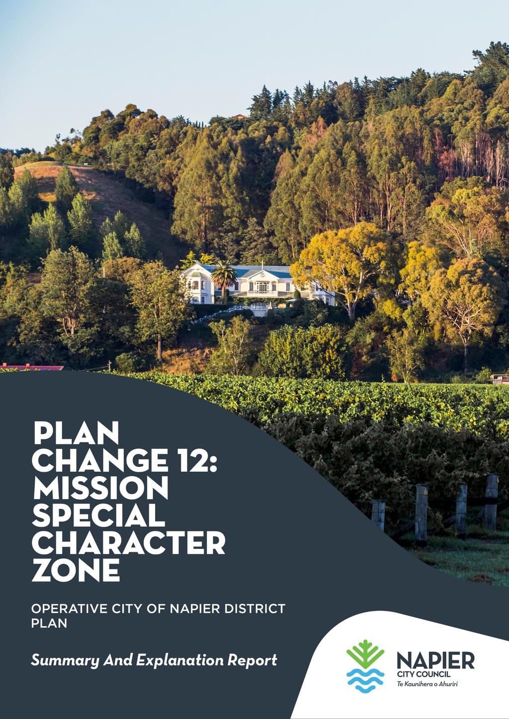
PUBLIC NOTICE UNDER CLAUSE 5 OF SCHEDULE 1 OF THE RESOURCE MANAGEMENT ACT 1991 PLAN CHANGE 12 TO THE OPERATIVE CITY OF NAPIER DISTRICT PLAN
|
|
|
- Wilfred Randall
- 6 years ago
- Views:
Transcription
1

 Limited, on the land best known as the site of the Mission Estate Winery and concert. The proposed zone is divided into four precincts.")
2 PUBLIC NOTICE UNDER CLAUSE 5 OF SCHEDULE 1 OF THE RESOURCE MANAGEMENT ACT 1991 PLAN CHANGE 12 TO THE OPERATIVE CITY OF NAPIER DISTRICT PLAN Public notice is given in accordance with Clause 5 of Schedule 1 of the Resource Management Act 1991 that the Napier City Council has adopted the following Plan Change to the Operative City of Napier District Plan: Plan Change 12 Mission Special Character Zone The purpose of Plan Change 12 is to provide for a new Mission Special Character Zone. This proposed zone is to replace existing zones across 288.6ha of land owned by Marist Holdings (Greenmeadows) Limited, on the land best known as the site of the Mission Estate Winery and concert. The proposed zone is divided into four precincts. The residential precinct will provide for approximately 550 households on an expanded Western Hills residential zone, accessed off Puketitiri Rd and predominantly covering the spurs facing westwards, behind the backdrop hills of Taradale and Greenmeadows. A landscape and visitor precinct is proposed in the vicinity of Mission Estate and the concert venue area. This precinct provides for the future development of boutique accommodation while preserving the landscape qualities of the backdrop hill behind the Mission winery. The productive rural and rural residential precincts are largely reflective of the existing Main Rural and Rural Residential zones of the District Plan. The objective of the proposed zone is to retain the productive flat and versatile land for agriculture, horticulture and viticulture and to ensure that the subdivision, use and development of the remainder of the property is undertaken in such a way as to maintain and enhance the key landscape features of the property. These objectives are to be achieved through the addition of the Mission Special Character Zone Structure Plan and design outcomes that establish a framework by which development in the zone will be assessed and managed. The proposed zone will also include a series of public walkways linking to the existing Council owned pathways in the vicinity. The proposed zone will create a new chapter in the District Plan covering the whole of the property with a number of minor consequential changes proposed in other chapters within the plan to accommodate the new zone. Because the proposed rezoning is comprehensive in nature and covers a large number of different District Plan provisions, it is recommended that interested parties refer to the primary source documents to fully understand the implications and extent of the proposed plan change.
3 Public Inspection Copies of the relevant documents of the proposed Plan Change 12 will be available for public viewing at: keyword: #planchange12 Napier City Council Customer Service Centre; and Napier City and Taradale Public Libraries; Any queries or requests for copies of Plan Change 12 can be made to the Napier City Council s City Development team by ing districtplan@napier.govt.nz or phoning Submissions Any person may make a submission on Plan Change 12. Submissions should be addressed the Team Leader Policy Planning and can be made either: Online: keyword #planchange12 ed to: districtplan@napier.govt.nz Posted to: Private Bag 6010, Napier 4182 Delivered to: Napier City Council Customer Service Centre, 215 Hastings St, Napier Any submissions in writing must be in the prescribed format (Form 5) of the Resource Management (Forms, Fees & Procedure) Regulations A copy of this form is available at the locations listed above. The closing date for submissions is 12pm, Friday 9 th March, 2018 Public Participation Process After the submission period has closed, Council will publicly notify a summary of the decisions sought by submitters on Plan Change 12. Public notice will be given inviting any person representing a relevant aspect of the public interest and any person that has an interest on the plan change greater than the interest the general public, to make a further submission in support or opposition to any of the submissions received. The Council will then hold a hearing of the submissions. All eligible persons who made a submission or further submission and who requested to be heard will be advised when and where their submission will be heard. Every eligible submitter will be notified of the Council s decision on their submission and the reasons for that decision. Any eligible submitter who is not satisfied with the Council s decision has the right to appeal the Council s decision to the Environment Court. Dean Moriarity TEAM LEADER POLICY PLANNING
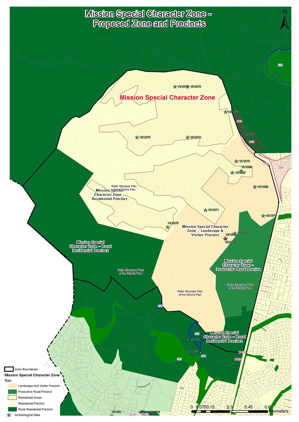
4 Summary and Explanation Report Mission Special Character Zone The land subject to the Plan Change is owned by Marist Holdings (Greenmeadows) Limited (MHL) and comprises the Mission Estate Winery and associated vineyard, a range of buildings on the lower slopes and areas of farmland and forestry. The total area of the property is 288.6ha and the Mission Special Character Zone is proposed over the whole property. The property is currently under a mixture of zonings in the Operative City of Napier District Plan, being the Western Hills Residential Zone (51ha), the Rural Residential Zone (207ha) and the Main Rural Zone (31ha). The residential development opportunity provided by the current Western Hills Residential Zone in the District Plan (all of which is within the MHL property) is considered to be suboptimal in terms of the character and amenity that would result from its development and in regard to market expectations. Therefore, following a reassessment of the opportunities for the site, a new 'special character zone' has been proposed for the whole property. Development objectives for the proposed future of the MHL land have been formulated in consultation with Napier City Council. These development objectives are to: Protect the visual amenity value of this landscape as a backdrop to Taradale and the City of Napier and in particular the integrity of the skyline; Provide connectivity as a walkway link across the Western Hills; Provide connectivity as part of an ecological corridor within the City Reserves Network; and Provide a different style of residential opportunity in Napier. The intent of the proposed zone is to retain the productive flat and versatile land for agriculture, horticulture and viticulture and to ensure that the subdivision, use and development of the remainder of the property is undertaken in such a way as to maintain and enhance the character of the landscape. The proposed zone is to be divided into precincts based on land use capabilities and landscape character protection principles. The proposed residential precinct includes the existing Western Hills Residential Zone and part of the existing Rural Residential Zone. The intent of the proposed residential precinct is to enable the establishment of a new community with a more distinctive character than currently provided for in the Western Hills Residential zoning. It is designed to have a character reflective of the heritage and landscape setting of Mission Estate and drawing on historical cues from Napier Hill. It is also designed to respond to the natural topography, including a low impact stormwater system and an extensive open space network utilising the gullies and valleys. The precinct will also provide for a variety of section sizes and housing types, and have a distinctive street layout in response to topography, resulting in a new place and a community, rather than just a new suburb. The proposed landscape and visitor precinct includes the existing hub of Mission Estate in the Grande Maison building and other buildings and facilities, including the concert venue. It also includes the backdrop hills framing the Mission landscape as viewed from Church Road.
5 This precinct is proposed to accommodate and provide for the existing hospitality activities of the Mission Estate. In protecting and enhancing the landscape values the steep eastern hillside is to be planted as woodland, including deciduous and evergreen trees. In the long term, individual trees on the lower slopes may be selectively harvested for timber and replanted. However, the trees on the upper slopes will be retained permanently to ensure the skyline of the landscape as viewed from Church Rd is enhanced by vegetation that also screens any visibility of buildings within the residential precinct on the hill tops. Walkways are also proposed for the landscape and visitor precinct connecting with the Napier City walkway network at either end of the property as well as providing walking access to the Grande Maison and to the proposed hill top reserve, and the walkway and street network proposed within the residential precinct. The landscape and visitor precinct also provides opportunity through the resource consent process, for the development of a boutique hotel (via the redevelopment of the accommodation buildings used by the former seminary) and discretely located and designed individual accommodation buildings termed Art Cabins. These Art Cabins are proposed to be separately located within or adjacent to the proposed woodland on the lower slopes of the hill within the area identified on the proposed structure plan map (Appendix 26B-1). The other two precincts proposed are the productive rural and rural residential precincts, which will be reflective of the existing Main Rural and Rural Residential zones respectively, with specific modifications appropriate to their setting within the wider Mission landscape. The Mission Special Character Zone Structure Plan Overall Map, on the following page, shows key features including: land use precincts within the Zone, indicative reserve areas, stormwater infrastructure, indicative road layout, indicative off-road public path routes, areas of proposed revegetation, notable existing buildings and structures, and areas to which specific planning provisions relate. The intent of the proposed zone is to retain the productive flat and versatile land for agriculture, horticulture and viticulture and to ensure that the subdivision, use and development of the remainder of the property is undertaken in such a way as to maintain and enhance the character of the landscape. Technical assessments have provided detail and information associated with: Urban design, landscape and visual effects, Recreation and open space, Traffic, Archaeology, Economic benefits, Stormwater and flooding, and Ecology. Specific details of the proposal and how to submit your views on this district plan change are stated on the public notice.
6 20 m 2. d Roa titiri Puke 1. Residential Precinct Productive Rural Precinct Church Scale: A4 Date: Existing Building Art Cabin Area Mission Estate Commercial Activity Area Public Paths Public Paths - Alternative Alignment Puketitiri Road Buffer Strip Reserve (Bridle Path) Bus Route - Existing - Potential Recorded Archaeological site Unison 33Kv Transmission Line Stormwater Management Wetlands Extent of Zone & Precinct Boundaries Trigger Area for Formation of Secondary Puketitiri Road Entrance ive Dr Structure Plan ui on Tir Legend: Neighbourhood Centre ha Indicative Urban Residential Development Extent Eastern Hill Face Woodland Revegetation Indicative Open Space including Reserve Areas Vineyard Grande Maison Concert Venue Indicative Internal Road Residential Collector Road 20 Neighbourhood Local m Reserves Prominent Visual Development Area Road Rural Residential Precinct Strea m Taipo 20 Landscape & Visitor Precinct m 12. Rural Residential 5. Precinct Main Puketitiri Road Entrance Secondary Puketitiri Road Entrance Indicative Neighbourhood Reserve Indicative Neighbourhood Centre Maryknoll 10. Concert Venue Farmhouse 11. Grande Maison Woolshed 12. Lookout Reserve Winery Buildings Concert Stage
7
8 Submission Form DISTRICT PLAN Office use only: Submission number: Date Received: Database: Date Entered: Initials: SUBMISSIONS ON PLAN CHANGE 12: Mission Special Character Zone Form 5, Clause 6 of the first schedule, Resource Management Act 1991 IMPORTANT NOTES FOR SUBMITTERS Submissions Close: 12pm, Friday 9 March 2018 Anyone is invited to make a submission. Submissions can be from an individual or on behalf of an organisation. You may either use this form or prepare your own submission being careful to use the same format. Submission can be made: Online: #planchange12 districtplan@napier.govt.nz Post: Team Leader Policy Planner Napier City Council Private Bag 6010, Napier 4142 Section 1: Applicant Details Name of Organisation: Contact Name: Address for Service: Contact no: Postcode: Section 2: Trade competition section I could / could not (select one) gain an advantage in trade competition through this submission I am / am not (select one) directly affected by an effect of the subject matter of the submission that: a) Adversely affects the environment; and b) Does not relate to trade competition or the effect of trade competition. *delete entire paragraph if you could not gain an advantage in trade competition through this submission Section 3: Submission Details Number of pages attached to this submission: Do you wish to be heard in support of your submission? Yes No If others make a similar submission, would you be prepared to consider presenting a joint case? Yes No Signature: Date: 215 Hastings Street, Napier 4110 Private Bag 6010, Napier t f e office@napier.govt.nz NAPIER CITY COUNCIL District Plan Submission Form Page 1 of 2
9 Section 4: Your Submission The specific provisions of the Plan Change that my submission relates to are: Give details: I seek the following decision from Napier City Council: Give precise details about the amendments you wish to make: e.g. retain provision, delete it, modify it in the following way, etc. My submission is: Include: support/opposition to specific parts of plan change, if you want amendments made, and reasons for your views: Attach additional pages if required. Important information: 1. The council must receive this submission before the closing date and time for submission on this Plan Change or Variation 2. Please note that submission are public. Your name and submission will be included in papers that are available to the media and the public. Your submission will only be used for the purpose of the Plan Change or Variation process. 3. Only those submitters who indicate they wish to speak at the hearing will be sent a copy of the planning report. A link to the report will be provided to all submitters. 215 Hastings Street, Napier 4110 Private Bag 6010, Napier t f e office@napier.govt.nz NAPIER CITY COUNCIL District Plan Submission Form Page 2 of 2
MISSION SPECIAL CHARACTER ZONE PLAN CHANGE. Marist Holdings (Greenmeadows) Ltd
 Ltd") Marist Holdings (Greenmeadows) Ltd MISSION SPECIAL CHARACTER ZONE PLAN CHANGE Assessment of Environmental Effects and Proposed Plan Change Description February 2018 (updated from original February 2017
Marist Holdings (Greenmeadows) Ltd MISSION SPECIAL CHARACTER ZONE PLAN CHANGE Assessment of Environmental Effects and Proposed Plan Change Description February 2018 (updated from original February 2017
What progress have we made so far? NEWSLETTER PROPOSED IONA RESIDENTIAL DEVELOPMENT UPDATE
 MAY 2017 NEWSLETTER PROPOSED IONA RESIDENTIAL DEVELOPMENT UPDATE The Iona Working Group has been set up to encourage discussions between the parties involved in the Environment Court Process. This newsletter
RURAL ZONE - POLICY. Rural Zone Policy. Issue: Rural Environment. Ruapehu District Plan Page 1 of 8
 Rural Zone Policy RU2 RURAL ZONE - POLICY RU2.1 Introduction The natural resources of the rural environment in the Ruapehu District provide the basis for the existing and potential character, intensity
I539. Smales 2 Precinct
 I539. Smales 2 Precinct I539.1. Precinct Description The Smales 2 Precinct applies to a 4.8 hectare block of land located on the southern side of Northcote Road and fronting Lake Pupuke, Takapuna. The
INCREMENTAL CHANGE AREA REVIEW March 2015 Page 1
 INCREMENTAL CHANGE AREA REVIEW March 2015 Page 1 Table of Contents Introduction... 3 Background to Review... 3 Comparison of the Schedules to the General Residential Zone... 7 Methodology... 7 Policy Context...
4 RESIDENTIAL ZONE. 4.1 Background
 4 RESIDENTIAL ZONE 4.1 Background The residential areas within the City are characterised by mainly lowrise dwellings sited on individual allotments. Past architectural styles, settlement patterns and
I Te Koti Taiao o Aotearoa Ōtautahi Rohe ENV-2018-CHC- Appellant. Queenstown Lakes District Council. Respondent
 In the Environment Court of New Zealand Christchurch Registry I Te Koti Taiao o Aotearoa Ōtautahi Rohe ENV-2018-CHC- Under In the matter of Between the Resource Management Act 1991 (RMA) An appeal under
I609. Penihana North Precinct
 I609. Penihana North Precinct I609.1. Precinct description The Penihana North Precinct is located south of the Swanson Railway Station, adjacent to the Rural Urban Boundary (RUB) and Waitakere Ranges Heritage
Chapter 2: OUTLINE PLANNING APPLICATION PROPOSALS. A New Garden Neighbourhood Matford Barton 17
 Chapter 2: OUTLINE PLANNING APPLICATION PROPOSALS A New Garden Neighbourhood Matford Barton 17 2.1. SUMMARY AND STATUS OF THE PROPOSALS 2.1.1. The parameter plans and associated wording in this chapter
SECTION ONE North East Industrial Zone Design Guide Palmerston North City Council June 2004
 SECTION ONE North East Industrial Zone Design Guide Palmerston North City Council June 2004 young heart easy living 1 Preface Industrial areas are a very important component of the economic well-being
9 CITY OF VAUGHAN OFFICIAL PLAN AMENDMENT NO BOCA EAST INVESTMENTS LIMITED
 9 CITY OF VAUGHAN OFFICIAL PLAN AMENDMENT NO. 631 - BOCA EAST INVESTMENTS LIMITED The Planning and Economic Development Committee recommends the adoption of the recommendations contained in the following
SECTION 7A: WHAKARONGO RESIDENTIAL AREA
 SECTION 7A: WHAKARONGO RESIDENTIAL AREA CONTENTS 7A.1 Introduction 1 7A.2 Resource Management Issues 1 7A.3 Objectives and Policies 1 7A.4 Methods 4 7A.5 Residential Zone 4 7A.5.1 Rules: Controlled Activities
HARDWICK GREEN, King s Lynn. Welcome to our Exhibition. What are your views? Introduction to the site and proposals. About us
 HARDWICK GREE, King s Lynn Welcome to our Exhibition Welcome to our exhibition, which is being held to provide you with the opportunity to understand and comment upon our proposals for new residential
Draft Ada Street Cardiff Area Plan
 Draft Ada Street Cardiff Area Plan (Draft Amendment to Lake Macquarie Development Control Plan 2014) Exhibition: The draft Area Plan is on public exhibition from 29 February 2016 to 29 March 2016. Submissions:
Proposed Variation to the Midleton Town Development Plan 2013
 Volume 1 Proposed Variation to the Midleton Town Development Plan 2013 Vacant Site Levy-Residential and Regeneration Areas Inclusion of new text and objective in relation to the Vacant Site Levy and Regeneration
I403 Beachlands 1 Precinct
 I403. Beachlands 1 I403.1. Precinct Description Beachlands is a rural and coastal village located on the eastern side of Auckland, adjoining the Tamaki Strait coastline. The original Beachlands village
Subdivision and Development
 Subdivision and Development 8.0 Introduction - Subdivision and Development The principle purpose of subdivision is to provide a framework for land ownership so that development and activities can take
Appendix 1 Structure plan guidelines
 Appendix 1 Structure plan guidelines This appendix forms part of the regional policy statement [rps]. 1.1. Introduction Structure plans are an important method for establishing the pattern of land use
4 Residential and Urban Living Zones
 4 Residential and Urban Living Zones Refer to Chapters 11 to 20 for additional rules that may apply to these zones. 4.1 OBJECTIVES AND POLICIES Objective Res1 Policy 1 Policy 2 Policy 3 Policy 4 Policy
Statement of Community Involvement LAND OFF SOUTHDOWN ROAD HORNDEAN, HAMPSHIRE
 LAND OFF SOUTHDOWN ROAD HORNDEAN, HAMPSHIRE CONTENTS Page 1. Introduction 3 2. Pre-application Discussions 4 3. The Consultation Process 5 4. Consultation Feedback 7 5. Responses to Consultation Feedback
Understanding Wellington City s DISTRICT PLAN
 Understanding Wellington City s DISTRICT PLAN Wellington City Council 1 UNDERTANDING WELLINGTON CITY S DISTRICT PLAN CONTENTS 1. Introduction...3 1.1. Overview of this Guide...3 1.2. What is the District
Section 6A 6A Purpose of the Natural Features and Landscapes Provisions
 Section 6A 6A Purpose of the Natural Features and Landscapes Provisions This Chapter addresses the protection and management of natural features and landscapes within the City. The City has a number of
Welcome. Walk Around. Talk to Us. Write Down Your Comments
 Welcome This is an information meeting introducing the applications for proposed redevelopment of the Yorkdale Shopping Centre site at 3401 Dufferin Street and 1 Yorkdale Road over the next 20+ years,
Exhibit A. 8:9 Scuffletown Rural Conservation District
 Exhibit A 8:9 Scuffletown Rural Conservation District 8:9.1 Intent and Purpose The Scuffletown Rural Conservation (SRC) District is intended to provide for residential development that supports the development
11.3 SPECIAL CHARACTER ZONE HAWKE S BAY REGIONAL SPORTS PARK
 11.3 SPECIAL CHARACTER ZONE HAWKE S BAY REGIONAL SPORTS PARK 11.3.1 INTRODUCTION The availability of sports and recreation activities and facilities is important for the maintenance and enhancement of
Planning Proposal Charlestown Swim and Leisure Centre LEP Amendment
 Planning Proposal Charlestown Swim and Leisure Centre LEP Amendment Amendment No. 4 to Lake Macquarie Local Environmental Plan 2014 (PP_2014_LAKEM_005_00) Local Government Area: Name of Draft LEP: Lake
I602. Birdwood Precinct
 I602. Birdwood Precinct I602.1. Precinct description The Birdwood Precinct applies to an area west of Don Buck Road and south of Red Hills Road in west Auckland. It incorporates subdivision and development
Examination of South Cambridgeshire Local Plan
 Matter SC6A - Policy SS/5 Waterbeach New Town Historic England( formerly English Heritage) 874 Rep Nos 59748, 60250, 60253 Examination of South Cambridgeshire Local Plan Historic England, Hearing Statement
Plan Modification to Chapter B2 of the Auckland Unitary Plan(AUP) Operative in part (15 November 2016)
 Operative in part (15 November 2016)") UNITARY PLAN UPDATE REQUEST MEMORANDUM TO FROM Phill Reid Linley Wilkinson DATE 25 September 2018 SUBJECT Plan Modification to Chapter B2 of the Auckland Unitary Plan(AUP) Operative in part (15 November
UNITARY PLAN UPDATE REQUEST MEMORANDUM TO FROM Phill Reid Linley Wilkinson DATE 25 September 2018 SUBJECT Plan Modification to Chapter B2 of the Auckland Unitary Plan(AUP) Operative in part (15 November
PRIVATE PLAN CHANGE REQUEST REZONING OF LAND AT 49, 57 AND 71 MILL ROAD FROM RURAL 3 ZONE TO MAIN RESIDENTIAL ZONE. Amendments to:
 PRIVATE PLAN CHANGE REQUEST REZONING OF LAND AT 49, 57 AND 71 MILL ROAD FROM RURAL 3 ZONE TO MAIN RESIDENTIAL ZONE Amendments to: MANUKAU OPERATIVE DISTRICT PLAN 2002 AUCKLAND REGIONAL POLICY STATEMENT
open space environment
 This section updated August 09 GUIDELINE TO THE RULES The Open Space Environment Rules apply to activities on sites within the Open Space Environment as shown on the Human Environments Maps. Most of the
Planning Proposal under section 55 of the EP&A Act
 FOR PUBLIC EXHIBITION [Brief description] Monday 10 October to Monday 27 October 2014 Planning Proposal under section 55 of the EP&A Act Port Macquarie-Hastings LEP 2011 (Amendment No 32) Mixed land zone
I615. Westgate Precinct
 I615. Westgate Precinct I615.1. Precinct Description The Westgate Precinct is located approximately 18km west of the Auckland city centre. There are seven Sub-precincts in the Westgate Precinct: Sub-precinct
OP Council Resolution June 16, Planning and Development Services
 OP-08-01 Council Resolution June 16, 2008 Planning and Development Services Kingsgate Landing Outline Plan Table of Contents 1.0 Introduction 1 1.1 Purpose of Plan 1 1.2 Plan Area Location 1 1.3 Ownership
Applicant Name Phone / Fax / Address City State Zip Code . Property Owner Phone / Fax / Address City State Zip Code
 Master Development Plan Application Community Development Department City of Redmond 411 SW 9 th Street Redmond, Oregon 97756 541-923-7721 541-548-0706 FAX Master Development Plan Fee $38,862.52 File Number
GREENBANK DEVELOPMENT MASTERPLAN
 DEVELOPMENT MASTERPLAN POTENTIAL TRAIN STATION COMMUNITY CENTRE Greenbank will be a connected masterplanned community providing easy access to local and surrounding amenity. Affordable quality homes, green
WELCOME GYPSY LANE. Wider Site Location plan. Proposals for the development of LAND OFF FOXLYDIATE LANE WEBHEATH. Proposals for the development of
 WELCOME The developers are preparing an outline planning application for a residential led development and need the community s views in order to develop the proposals further WHAT IS PROPOSED? A high
REMARKABLES PARK ZONE
 .10 Remarkables Park Zone.10.1 Resources, Activities and Values The Remarkables Park Area comprises approximately 150 hectares of perimeter urban land in the vicinity of Frankton and occupies a strategic
South of Eastern Strategic Direction Status Update
 STAFF REPORT ACTION REQUIRED South of Eastern Strategic Direction Status Update Date: July 10, 2014 To: From: Planning and Growth Management Committee Chief Planner and Executive Director, City Planning
In the Environment Court of New Zealand Christchurch Registry ENV-2016-CHC- Appellants. Otago Regional Council. Respondent
 In the Environment Court of New Zealand Christchurch Registry ENV-2016-CHC- Under In the matter of Between the Resource Management Act 1991 (RMA) an appeal under Clause 14(1), First Schedule of the RMA
WELLINGTON CITY DISTRICT PLAN
 Section 32 Report WELLINGTON CITY DISTRICT PLAN PROPOSED DISTRICT PLAN CHANGE 54 REZONING 178 AND 180 OWHIRO BAY PARADE 1 Introduction Before a Proposed District Plan change is publicly notified the Council
2.0 AREA PLANS. Lakeside Business District. Lakeside Business District Land Use Categories:
 Lakeside Business District Lakeside Business District Land Use Categories: Campus Commercial Campus Commercial means a mixture of uses which includes corporate offices, office parks, hotels, commercial,
Land Use Amendment in Southwood (Ward 11) at and Elbow Drive SW, LOC
 at and Elbow Drive SW, LOC") 2018 November 15 Page 1 of 10 EXECUTIVE SUMMARY This land use amendment application was submitted by Rick Balbi Architect on 2017 August 31 on behalf of Sable Developments Ltd, and with authorization from
2018 November 15 Page 1 of 10 EXECUTIVE SUMMARY This land use amendment application was submitted by Rick Balbi Architect on 2017 August 31 on behalf of Sable Developments Ltd, and with authorization from
Linden Homes Proposals for land off Ringwood Road, Verwood
 Welcome Welcome to Linden Homes first public exhibition displaying proposals for new homes on land off Ringwood Road in Verwood. Award-winning house builder Linden Homes, part of the Galliford Try Group,
6. REGIONAL AND COMMUNITY FACILITIES DESIGNATIONS 6.1. OBJECTIVES FOR REGIONAL AND COMMUNITY FACILITIES LAND USE DESIGNATIONS
 6. REGIONAL AND COMMUNITY FACILITIES DESIGNATIONS INTRODUCTION The Regional and land use designations provide the primary locations for uses which satisfy the health, education and other service needs
Issue 1 Protection of the special environmental qualities of the Hanmer Basin.
 Environments of special concern Issue 19 Hanmer Basin The Hanmer Basin is a special area, being a popular retirement and holiday destination as well as having considerable environmental and conservation
Tāhuhu whakaruruhau ā-taone The sheltering ridge pole
 B2. Tāhuhu whakaruruhau ā-taone - Urban growth and form B2.1. Issues Tāhuhu whakaruruhau ā-taone The sheltering ridge pole Auckland s growing population increases demand for housing, employment, business,
Urban Growth Boundaries
 Urban Growth Boundaries Discussion Document July 2008 Contents page Introduction... 3 What are urban growth boundaries?... 3 The need to manage growth... 3 Purpose of urban growth boundaries... 4 How will
Statement of Environmental Effects
 Statement of Environmental Effects Pro-forma for minor development This pro-forma may be used for minor development proposals that require a development application. This pro-forma is not comprehensive
Appendix 7 Precinct Analysis Carlton
 Appendix 7 Precinct Analysis Carlton (Andover Street) Rezone from R2 Low Density Residential to R3 Medium Density Residential Retain existing B1 Neighbourhood Centre zone Existing Zoning Map (R2 Low Density
QUEENSTOWN LAKES DISTRICT COUNCIL SUBDIVISION DESIGN GUIDELINES
 Attachment C: Draft QLDC Subdivision Design Guidelines QUEENSTOWN LAKES DISTRICT COUNCIL DESIGN GUIDELINES A DESIGN GUIDE FOR AND DEVELOPMENT IN THE URBAN ZONES QUEENSTOWN OFFICE 10 Gorge Road Queenstown
Rural (Urban Expansion) Environment
 Environment") RUEE.1 Rural (Urban Expansion) Environment Subsequent to the receipt of appeals, a 'marked up' version of the Proposed District Plan was prepared. The provisions of the Proposed Version of the Plan subject
RUEE.1 Rural (Urban Expansion) Environment Subsequent to the receipt of appeals, a 'marked up' version of the Proposed District Plan was prepared. The provisions of the Proposed Version of the Plan subject
SPECIAL 35 (HIBISCUS COAST GATEWAY) ZONE
 ZONE") `` 12.8.35 SPECIAL 35 (HIBISCUS COAST GATEWAY) ZONE 12.8.35.1 Issues The following provisions relate to the Hibiscus Coast Gateway Zone. This zone is located at Silverdale in the area bounded by State
`` 12.8.35 SPECIAL 35 (HIBISCUS COAST GATEWAY) ZONE 12.8.35.1 Issues The following provisions relate to the Hibiscus Coast Gateway Zone. This zone is located at Silverdale in the area bounded by State
EVIDENCE OF CAREY VIVIAN (PLANNER) 13 JUNE 2018
 13 JUNE 2018") QUEENSTOWN-LAKES DISTRICT COUNCIL PROPOSED DISTRICT PLAN HEARING STREAM 14 IN THE MATTER of a hearing on submissions to the Proposed District Plan Stage 2 and Variation 1 pursuant to clause 8B of the First
QUEENSTOWN-LAKES DISTRICT COUNCIL PROPOSED DISTRICT PLAN HEARING STREAM 14 IN THE MATTER of a hearing on submissions to the Proposed District Plan Stage 2 and Variation 1 pursuant to clause 8B of the First
WELLINGTON CITY COUNCIL REPORT OF THE HEARING COMMITTEE SUBJECT: PROPOSED DISTRICT PLAN CHANGE 47:TAKAPU ISLAND REZONING
 Approved by Council - 10 October 2007 WELLINGTON CITY COUNCIL REPORT OF THE HEARING COMMITTEE SUBJECT: PROPOSED DISTRICT PLAN CHANGE 47:TAKAPU ISLAND REZONING COMMITTEE MEMBERS: CRS Foster (Chair) McKinnon
INTRODUCTION. Land West of Main Road, Stanton Harcourt THE SITE. Why is the Site Suitable for Development?
 0 INTRODUCTION THE SITE Application Boundary Gladman Developments Ltd has successfully invested in communities throughout the UK over the past 0 years, developing high quality and sustainable residential,
Section 12C Subdivision in the Rural Residential Zone
 Section 12C 12C Subdivision in the Rural Residential Zone The Rural Residential Zone provides part of the range of residential opportunities within the City. Land zoned rural residential is considered
Planning Proposal Concurrent DA/LEP Amendment for Belmont North Pharmacy Amendment No. 24 to Lake Macquarie Local Environmental Plan (LMLEP) 2014
 2014") Planning Proposal Concurrent DA/LEP Amendment for Belmont North Pharmacy Amendment No. 24 to Lake Macquarie Local Environmental Plan (LMLEP) 2014 Local Government Area: Name of Draft LEP: Subject Land:
Planning Proposal Concurrent DA/LEP Amendment for Belmont North Pharmacy Amendment No. 24 to Lake Macquarie Local Environmental Plan (LMLEP) 2014 Local Government Area: Name of Draft LEP: Subject Land:
7437, 7439 and 7441 Kingston Road - Zoning By-law Amendment and Site Plan Control Applications - Preliminary Report
 STAFF REPORT ACTION REQUIRED 7437, 7439 and 7441 Kingston Road - Zoning By-law Amendment and Site Plan Control Applications - Preliminary Report Date: August 13, 2015 To: From: Wards: Reference Number:
Proposed Kenmount Hill CDS Amendment. Public Hearing October 25 th, 2018
 Proposed Kenmount Hill CDS Amendment Public Hearing October 25 th, 2018 History of Kenmount Hill Why Kenmount Hill? Why Now? We are a city with a vision for growth and the development of Kenmount Hill
Institutional Master Plan The Arnold Arboretum of Harvard University
 Institutional Master Plan The Arnold Arboretum of Harvard University Submitted to: Boston Redevelopment Authority One City Hall Square Boston, MA 02201 Submitted by: The Arnold Arboretum of Harvard University
LAND USE AMENDMENT CORNERSTONE (WARD 3) 60 STREET NE AND COUNTRY HILLS BOULEVARD NE MAP 26NE BYLAW 22D2017
 60 STREET NE AND COUNTRY HILLS BOULEVARD NE MAP 26NE BYLAW 22D2017") Page 1 of 14 EXECUTIVE SUMMARY This Land Use Amendment application covers an area of 43.76 hectares ± (108.14 acres ±) located in northeast Calgary, bound by Country Hills Boulevard NE to the south and
Page 1 of 14 EXECUTIVE SUMMARY This Land Use Amendment application covers an area of 43.76 hectares ± (108.14 acres ±) located in northeast Calgary, bound by Country Hills Boulevard NE to the south and
Sustainable South Warrington s Thoughts on the Preferred Development Option put forward by Warrington Borough Council
 s Thoughts on the Preferred Development Option put forward by Warrington Borough Council Context for these thoughts was originally formed by a group of local residents and local councillors to object to
I209 Quay Park Precinct
 I209. Quay Park I209.1. Precinct description The Quay Park Precinct is located on reclaimed land at the eastern end of the city centre and along the City Centre waterfront. It is dissected to the east
Section Three, Appendix 16C Medium Density Housing, Design Assessment Criteria (Residential 8A zone)
") APPENDIX 16C MEDIUM DENSITY HOUSING, DESIGN ASSESSMENT CRITERIA (RESIDENTIAL 8A ZONE) PURPOSE OF APPENDIX 16C (RESIDENTIAL 8A ZONE) In the Residential 8A Zone the following are defined as restricted discretionary
APPENDIX 16C MEDIUM DENSITY HOUSING, DESIGN ASSESSMENT CRITERIA (RESIDENTIAL 8A ZONE) PURPOSE OF APPENDIX 16C (RESIDENTIAL 8A ZONE) In the Residential 8A Zone the following are defined as restricted discretionary
COUNTY COUNCIL OF PRINCE GEORGE'S COUNTY, MARYLAND SITTING AS THE DISTRICT COUNCIL 2010 Legislative Session. Council Members Dernoga and Olson
 DR- COUNTY COUNCIL OF PRINCE GEORGE'S COUNTY, MARYLAND SITTING AS THE DISTRICT COUNCIL 00 Legislative Session Bill No. CB--00 Chapter No. Proposed and Presented by Introduced by Co-Sponsors The Chairman
Rural (Urban Expansion) Environment
 Environment") RUEE.1 Rural (Urban Expansion) Environment Index RUEE.1 RUEE.1.1 RUEE.1.2 RUEE.1.3 RUEE.1.4 RUEE.2 RUEE.2.1 RUEE.2.2 RUEE.2.3 RUEE.2.4 RUEE.3 Rural (Urban Expansion) Environment Description and Expectations
RUEE.1 Rural (Urban Expansion) Environment Index RUEE.1 RUEE.1.1 RUEE.1.2 RUEE.1.3 RUEE.1.4 RUEE.2 RUEE.2.1 RUEE.2.2 RUEE.2.3 RUEE.2.4 RUEE.3 Rural (Urban Expansion) Environment Description and Expectations
Appendix A- A - Relief sought
 Appendix A- A - Relief sought Chapters 3 Strategic Direction 3.2.5 The retention of the District s distinctive landscapes. (addresses Issues 2 and 4) It is unclear whether provision 3.2.5 is a heading
Hearing Topic: 058 Public Open Space. Primary Evidence: from Andrea Broughton
 Submitter: Andrea & Alex Broughton Submission Number: 5650-1 Hearing Topic: 058 Public Open Space Primary Evidence: from Andrea Broughton Date: 10 June 2015 1. Introduction My name is Andrea Broughton
Neighbourhood Planning Site Assessment Pro-forma and Guide Version 2
 Neighbourhood Planning Site Assessment Pro-forma and Guide Version 2 September 2014 Site HNP 006 Land East of Stanbridge Road and North of Lower Road 1. Background information Site location and use Site
Guidance Notes Completing an AEE
 Guidance Notes Completing an AEE The purpose of this guidance note is to assist you with completing your Assessment of Environmental Effects (AEE) for your land-use consent application. If you do not provide
280 Manse Road - Official Plan Amendment, Zoning Amendment, Draft Plan of Subdivision Applications - Preliminary Report
 STAFF REPORT ACTION REQUIRED 280 Manse Road - Official Plan Amendment, Zoning Amendment, Draft Plan of Subdivision Applications - Preliminary Report Date: March 11, 2014 To: From: Wards: Reference Number:
... on the draft Arden Vision & Framework
 April 2017 Integrated world-class urban renewal Feedback... on the draft Arden Vision & Framework On 1 September 2016 the Victorian Planning Authority (VPA) released the draft Arden Vision & Framework
The West Vaughan Employment Area Secondary Plan Policies
 Part 2: The West Vaughan Employment Area Secondary Plan Policies 2.1 General Policies It is the policy of Council: 2.1.1. That the West Vaughan Employment Area (the WVEA), identified on Schedule 1, will
Plan Change 56: Fire Fighting Water Supplies Code of Practice
 Plan Change 56: Fire Fighting Water Supplies Code of Practice n_292117 Contents 1. INTRODUCTION... 1 2. WHAT IS THE CODE?... 1 3. WHEN IS THE CODE APPLIED?... 1 4. ARE YOU AT RISK?... 1 5. HOW ARE HOUSE
H7 Open Space zones. (a) provide for the needs of the wider community as well as the needs of the community in which they are located;
 provide for the needs of the wider community as well as the needs of the community in which they are located;") H7. Open Space zones H7.1. Background The majority of land zoned as open space is vested in the Council or is owned by the Crown. However some areas zoned open space are privately owned. While the open
H7. Open Space zones H7.1. Background The majority of land zoned as open space is vested in the Council or is owned by the Crown. However some areas zoned open space are privately owned. While the open
COMMUNITY DESIGN. GOAL: Create livable and attractive communities. Intent
 COMMUNITY DESIGN Intent An attractive, well-designed County will attract quality development, instill civic pride, improve the visual character of the community, and create a strong, positive image for
SECTION 2.4 URBAN DEVELOPMENT AND STRATEGIC URBAN DIRECTIONS
 SECTION 2.4 URBAN DEVELOPMENT AND STRATEGIC URBAN DIRECTIONS 2.4.1 INTRODUCTION In 1993/94 the Hastings District Council completed the Hastings Urban Development Strategy. The purpose of this study was:
Huapai North. Variation 127 DECISIONS VERSION. Variation 127 Special 29 Zone
 Huapai North Variation 127 DECISIONS VERSION DECISIONS VERSION The amendments to the Variation that have been made as a result of decisions on submissions are shown as strikethrough or underlined. RESOURCE
MAYFIELD WEST SECONDARY PLAN PHASE 2
 MAYFIELD WEST SECONDARY PLAN PHASE 2 Public Open House #3 February 25, 2010 Draft Preferred Land Use Scenario TOWN OF CALEDON PLANNING & DEVELOPMENT DEPARTMENT Open House Agenda TOWN OF CALEDON 1. Welcome
DAVENPORT VILLAGE SECONDARY PLAN
 27 DAVENPORT VILLAGE SECONDARY PLAN 27. DAVENPORT VILLAGE SECONDARY PLAN 1. VISION FOR THE DAVENPORT VILLAGE SECONDARY PLAN Davenport Village, municipally known as 830, 940, 980 and 1100 Lansdowne Avenue,
11.4 Highway 400 North Employment Lands Secondary Plan
 11.4 Highway 400 North Employment Lands Secondary Plan APPROVED BY THE ONTARIO MUNICIPAL BOARD ON NOVEMBER 21, 2011 11.4.1 General 11.4.1.1. The following policies and Schedules A - I form Official Plan
Lake Macquarie City. A copy of the published amendment including the instrument and maps, is provided in Attachment 7 of this report.
 Planning Proposal Amendment No. 77 to Lake Macquarie Local Environmental Plan 2004 and proposed Amendment to Draft Lake Macquarie Local Environmental Plan 2013 Minor Zone Boundary Adjustment - Pasminco
Site Option 3: Te Matai
 Site Option 3: Te Matai Location Napier Drain looking south east Description The Te Matai growth option is located between the existing residential boundary (Ruamahanga Crescent) Napier Road (State Highway
Subdivision Design Criteria. Penihana North GUIDELINES TO THE RULES
 Created September 2013 Penihana North Subdivision Design Criteria GUIDELINES TO THE RULES This part of the Plan sets out the design criteria for subdivision in Penihana North. The criteria will be considered
8 Oak Street - Official Plan and Zoning By-law Amendment Application - Preliminary Report
 STAFF REPORT ACTION REQUIRED 8 Oak Street - Official Plan and Zoning By-law Amendment Application - Preliminary Report Date: March 17, 2014 To: From: Wards: Reference Number: Planning and Growth Management
Longhorsley Neighbourhood Plan
 Site Assessment 1. The availability of the site 1.1 Is the land owner willing for their site to be made available for development? 1.2 If yes, do you have any written evidence to back this up? Planning
4155 Yonge Street Official Plan Amendment and Rezoning Application Preliminary Report
 STAFF REPORT ACTION REQUIRED 4155 Yonge Street Official Plan Amendment and Rezoning Application Preliminary Report Date: May 5, 2011 To: From: Wards: Reference Number: North York Community Council Director,
11.4 Highway 400 North Employment Lands Secondary Plan APPROVED BY THE ONTARIO MUNICIPAL BOARD ON NOVEMBER 21, 2011
 11.4 Highway 400 North Employment Lands Secondary Plan APPROVED BY THE ONTARIO MUNICIPAL BOARD ON NOVEMBER 21, 2011 11.4.1 General 11.4.1.1. as approved by the Ontario Municipal Board on November 21, 2011,
QUEENSTOWN LAKES DISTRICT COUNCIL
 QUEENSTOWN LAKES DISTRICT COUNCIL Hearing of Submissions on the Proposed District Plan Report 16.9 Report and Recommendations of Independent Commissioners Regarding Upper Clutha Planning Maps Lake McKay
LAND USE AMENDMENT CORNERSTONE (WARD 3) COUNTRY HILLS BOULEVARD AND STONEY TRAIL NE BYLAW 9D2017
 COUNTRY HILLS BOULEVARD AND STONEY TRAIL NE BYLAW 9D2017") Page 1 of 12 EXECUTIVE SUMMARY This Land Use Amendment application covers an area of 54.92 hectares ± (135.71 acres ±) located in northeast Calgary, bound by Country Hills Boulevard NE to the north and
Page 1 of 12 EXECUTIVE SUMMARY This Land Use Amendment application covers an area of 54.92 hectares ± (135.71 acres ±) located in northeast Calgary, bound by Country Hills Boulevard NE to the north and
1.0 Purpose of a Secondary Plan for the Masonville Transit Village
 Report to Planning and Environment Committee To: Chair and Members Planning & Environment Committee From: John M. Fleming Managing Director, Planning and City Planner Subject: Masonville Transit Village
ARLINGTON COUNTY, VIRGINIA. County Board Agenda Item Meeting of June 16, 2018
 ARLINGTON COUNTY, VIRGINIA County Board Agenda Item Meeting of June 16, 2018 DATE: June 7, 2018 SUBJECT: Z-2604-18-1 Rezoning from R-6 and R-5 Single Family Residential Districts to S-3A Special District
Perth and Kinross Council Development Management Committee 20 February 2013 Report of Handling by Development Quality Manager
 Perth and Kinross Council Development Management Committee 20 February 2013 Report of Handling by Development Quality Manager 4(4)(iii) 13/81 Erection of sports hall, associated changing facilities, offices
EXECUTIVE SUMMARY DRAFT CHAPTER 1 INTRODUCTION EXECUTIVE SUMMARY
 CHAPTER 1 EXECUTIVE SUMMARY INTRODUCTION Through the joint efforts of the City of Tulsa planning staff and the Land Services division of Indian Nations Council of Governments (INCOG), the Berryhill Land
SCHEDULE 10 TO THE URBAN GROWTH ZONE. Shown on the planning scheme map as UGZ10. Truganina Precinct Structure Plan. 1.0 The Plan
 SCHEDULE 10 TO THE URBAN GROWTH ZONE Shown on the planning scheme map as UGZ10 Truganina Precinct Structure Plan 1.0 The Plan Map 1 shows the future urban structure proposed in the Truganina Precinct Structure
6 Landsc apes and rur al char ac
 LANDSCAPES AND RURAL CHARACTER QLDC PROPOSED DISTRICT PLAN [PART TWO] DECISION VERSION ter 6 Landsc apes and rur al char ac 6.1 Purpose Appendix C QLDC DISTRICT PLAN [PART TWO] DECISION VERSION 6 Landsc
Osceola County Board of County Commissioners 1 Courthouse Square, Suite 1100 Kissimmee, FL
 1/10/11 Item Number DRI08-0006 Osceola County Board of County Commissioners 1 Courthouse Square, Suite 1100 Kissimmee, FL 34741 407-742-0200 Applicant & Owner Center Lake Properties, LLLP and Formally
PART II APPENDIX 3: COASTAL TASMAN AREA SUBDIVISION AND DEVELOPMENT DESIGN GUIDE
 Operative Part II, Appendix 3 Coastal Tasman Area Subdivision and Development Design Guide 26 September 2009 PART II APPENDIX 3: COASTAL TASMAN AREA SUBDIVISION AND DEVELOPMENT DESIGN GUIDE CHAPTER 1 -
INTRODUCTION. Land south of Bishopswood Lane, Tadley
 0 INTRODUCTION THE SITE Introduction Gladman Developments Ltd. has successfully invested in communities throughout the UK over the past 0 years, developing high quality and sustainable residential, commercial