MONTGOMERY COUNTY PLANNING DEPARTMENT THE MARYLAND-NATIONAL CAPITAL PARK AND PLANNING COMMISSION
|
|
|
- Joleen Knight
- 6 years ago
- Views:
Transcription


1 MONTGOMERY COUNTY PLANNING DEPARTMENT THE MARYLAND-NATIONAL CAPITAL PARK AND PLANNING COMMISSION MCPB Item No. Date: Rock Spring Master Plan Public Hearing Draft: Worksession 2 Nancy Sturgeon, Master Planner Supervisor, Master Plan Team, Area 2 Division, Nancy.Sturgeon@montgomeryplanning.org, Luis R. Estrada Cepero, Planner Coordinator, Urban Designer, Area 2 Division, Luis.Estrada@montgomeryplanning.org, Khalid Afzal, Acting Chief, Area 2 Division, Khalid.Afzal@montgomeryplanning.org, Summary The Planning Board s public hearing on the Rock Spring Master Plan was held on December 1, 2016 and the public hearing record was open until the close of business on December 15, The Board s first worksession on the Plan was held on December 15, The second Planning Board worksession will be on January 19, As requested by the Planning Board at the end of the first worksession, staff will present options for how several properties in Rock Spring could redevelop. These options will be presented for discussion purposes as the Board considers the property owner s zoning requests. The written public hearing testimony is summarized in Attachment 1. All of the written testimony received as part of the public hearing record is attached, including technical comments from the Departments of Transportation, Environmental Protection, and Recreation, which will be addressed at a future worksession, as needed. Rock Spring Master Plan worksession schedule: December 15, 2016 Planning Board Worksession #1 January 19, 2017 Planning Board Worksession #2 February 2, 2017 Planning Board Worksession #3 February 16, 2017 Planning Board Worksession #4, if needed March 2, 2017 Planning Board Worksession #5, if needed Completed: The Planning Board should bring their copies of the Public Hearing Draft that were previously distributed to them. Attachments: 1. Summary of Written Public Hearing Testimony 2. Written Testimony
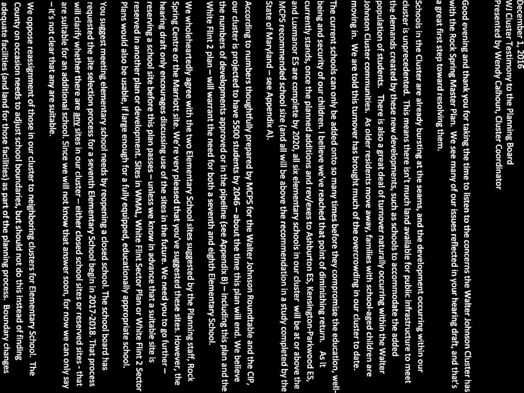
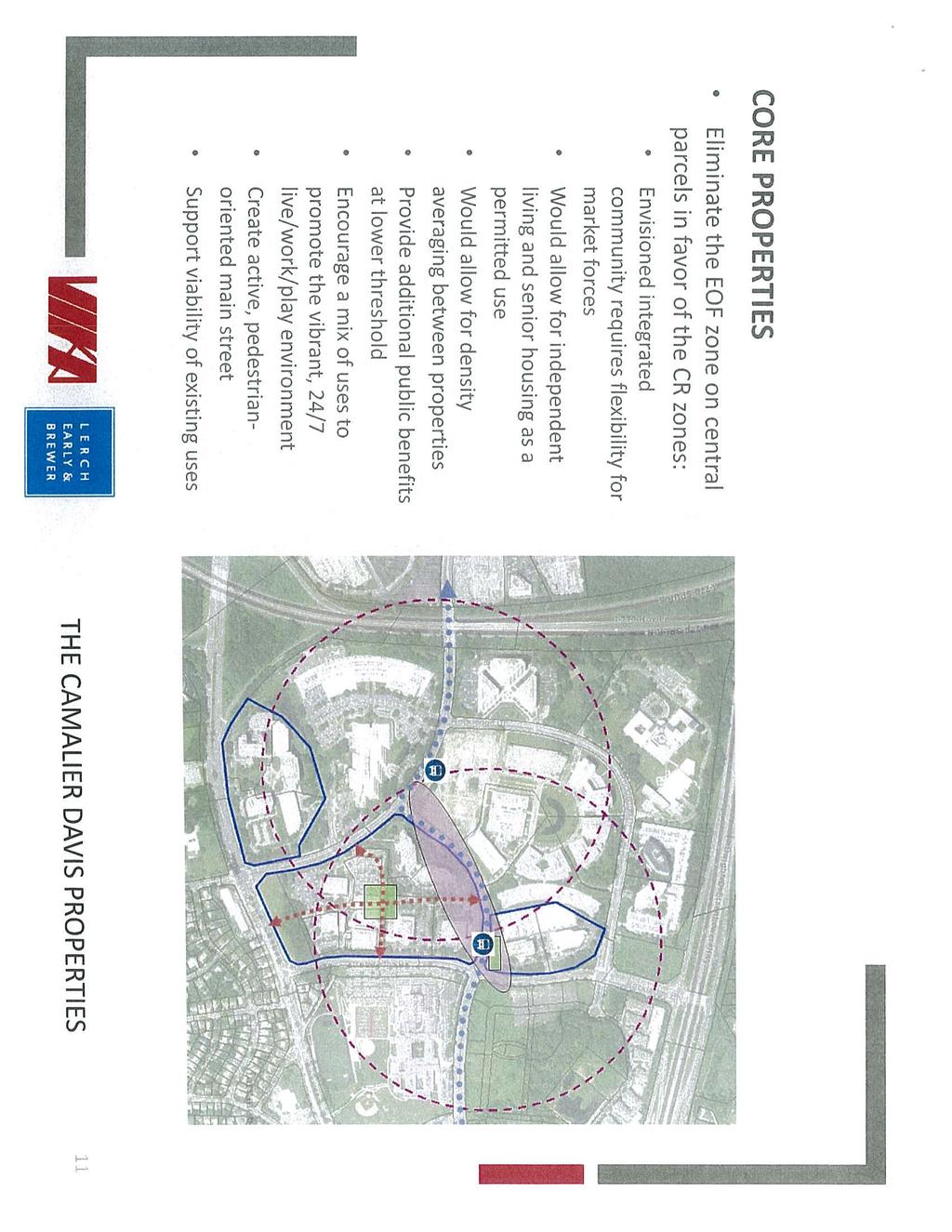
2 Attachment 1 Rock Spring Master Plan: Summary of Written Public Hearing Testimony Issue/Property Page Testimony or Comment Staff Response Planning Board Direction 1. Walter Johnson Cluster 26, Agree with Plan s suggestion for possible school on Rock Spring Centre or Marriott sites, but must reserve now unless a suitable site is reserved elsewhere. Board should delay this Plan and White Flint 2 until sites for two elementary schools and one middle school are identified/reserved and/or the County has means to acquire. Opposed to proposed road between WJHS and Georgetown Square. Wendy Calhoun, Cluster Coordinator MCPS continues to work on options to address school capacity issues in the Walter Johnson Cluster. The recommendations in the Master Plan are as specific as staff feels is appropriate for a long-range plan. The area needs greater connectivity and the proposed road between Democracy Boulevard and Rock Spring Drive would assist pedestrians and bicyclists. 2. Democracy Center 6901 Rockledge Drive 30, 49 Requests CRT zone through the Master Plan (not via a future floating zone application) or amend the EOF zone to permit any mix of uses approved by the Board at site plan. Objects to Plan s recommendations that existing private open space be open to the public and requests removal of this language. If the Parks Department wants to acquire the open space, the site should be given mixed use zoning with a higher density for the developable land. Francoise M. Carrier Existing Zoning: EOF-1.25, H PH Draft Zoning: EOF-1.5, H-150 Owner s Request: CRT or modified EOF zone Staff will present options for the Board to discuss and consider during the worksessions. Staff understands the objection of the property owner to having its private property open to the public, which is why staff is interested in acquiring the open space for public use as a public park. 1 PH = Rock Spring Public Hearing Draft Master Plan 1 P a g e
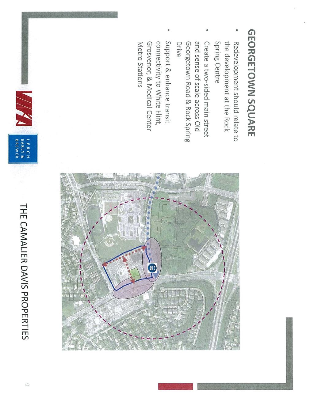
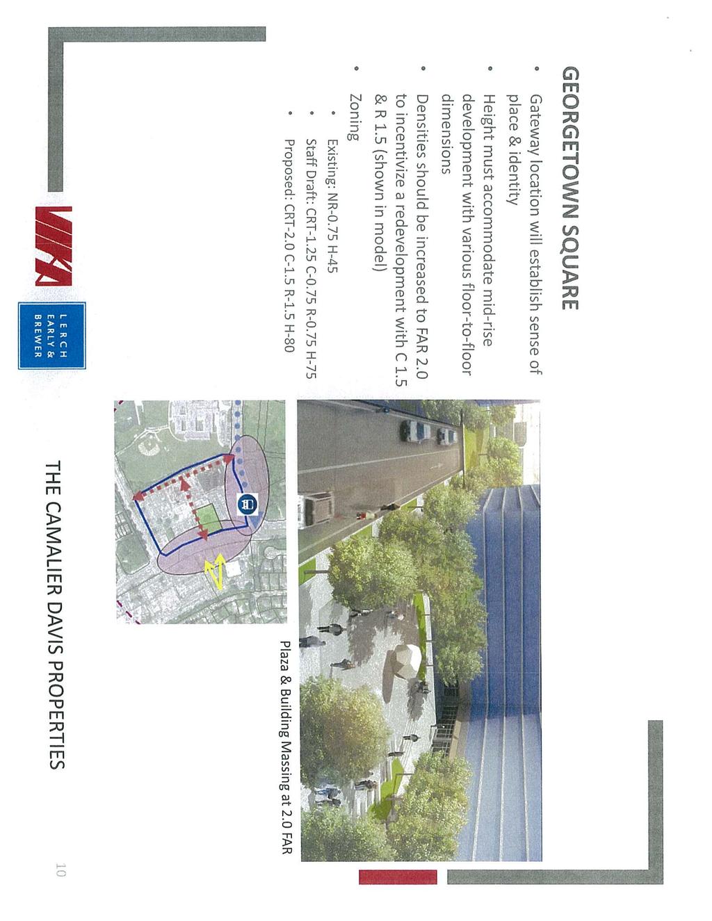
3 Attachment 1 Rock Spring Master Plan: Summary of Written Public Hearing Testimony Issue/Property Page Testimony or Comment Staff Response Planning Board Direction 3. Camalier Davis Properties - Rock Spring Centre 26, 28, 50 To achieve property owner s vision, density should be 2.0 FAR. Plan s suggestion that Rock Spring Centre site could provide possible school site or recreation/open space, if the approved plan were amended, is extremely problematic and will hinder site s marketability. Steven A. Robins and Patrick L. O Neil Existing Zoning: CR-1.5, C-0.75, R-0.75, H-275 PH Draft Zoning: CR-1.5, C-0.75, R-0.75, H-275 Owner s Request: CR-2.0, C-1.5, R-1.5, H-275 Staff continues to support the Draft Plan s proposed zoning recommendation for this property and the suggestion that a school site be considered if the approved plan were amended. 4. Camalier Davis Properties - Georgetown Square 5. Camalier Davis Properties - Rockledge Executive Plaza One (6600 Rockledge Drive) and Two (6610 Rockledge Drive) 6. Camalier Davis Properties - Rock Spring North: 6500, 6550, 6560 Rock Spring Drive; 6430 Rockledge Drive 25 Densities and heights need to be significant to encourage redevelopment at this gateway location. Steven A. Robins and Patrick L. O Neil Increase density to 2.5 FAR and height to 275 feet to provide incentive to redevelop. Steven A. Robins and Patrick L. O Neil Increase density to 2.5 FAR and height to 225 feet to provide incentive to redevelop; these densities and heights are appropriate and compatible with the surrounding area. Steven A. Robins and Patrick L. O Neil Existing Zoning: NR-0.75, H-45 PH Draft Zoning: CRT-1.25, C-0.75, R-0.75, H-75 Owner s Request: CRT-2.0, C-1.5, R-1.5, H-80 Staff continues to support the Draft Plan s proposed zoning recommendation for this property. Existing Zoning: EOF-1.0, H-100 PH Draft Zoning: EOF-1.5, H-100 Owner s Request: CR-2.5, C-2.0, R-2.0, H-275 Staff will present options for the Board to discuss and consider during the worksessions. Existing Zoning: EOF-1.0, 1.25, 1.5; H-100 PH Draft Zoning: EOF-1.5, H-100 Owner s Request: CR-2.5, C-2.0, R-2.0, H-225 Staff will present options for the Board to discuss and consider during the worksessions. 2 P a g e
4 Attachment 1 Rock Spring Master Plan: Summary of Written Public Hearing Testimony Issue/Property Page Testimony or Comment Staff Response Planning Board Direction 7. Camalier Davis Properties - Rock Spring South: Fernwood Road; 6410, 6420 Rockledge Drive 8. Camalier Davis Properties - Democracy Plaza One and Two and Marriott Suites Hotel: 6701, 6707, 6711 Democracy Blvd Increase density to 2.5 FAR and height to 150 to provide incentive to redevelop. Steven A. Robins and Patrick L. O Neil Increase density to 2.5 FAR and height to 150 to provide incentive to redevelop. Steven A. Robins and Patrick L. O Neil Existing Zoning: EOF-1.0, H-100 PH Draft Zoning: EOF-1.5, H-100 Owner s Request: CR-2.5, C-2.0, R-2.0, H-150 Staff will present options for the Board to discuss and consider during the worksessions. Existing Zoning: EOF-1.0, H-110 PH Draft Zoning: EOF-1.5, H-110 Owner s Request: CR-2.5, C-2.0, R-2.0, H-150 Staff will present options for the Board to discuss and consider during the worksessions. 9. Marriott Property Fernwood Road 20, 21, 30, 31, 42 Allowable uses for non-office commercial and residential uses need to be expanded, by either modifying the EOF zone or rezoning to CR zone. Allowable height should be increased from 100 to 150. Property should not be recommended for school site consideration. Nancy Regelin and David D. Freishtat Existing Zoning: EOF-0.75, H-100 Proposed Zoning: EOF-1.5, H-100 Owner s Request: Modified EOF zone or CR 1.5, C-1.5, R-1.0, H-150 Staff will present options for the Board to discuss and consider during the worksessions. Staff believes that the feasibility of a new school, on some portion of the site, when it redevelops, should be considered. 10. Westfield Montgomery Mall 33 Westfield supports the existing zoning, but proposes a zoning text amendment for the Regional Shopping Center Overlay Zone to allow multi-family residential uses at a maximum building height of 150 feet to accommodate future interest in adding housing, as permitted by the GR zone. Patricia Harris Existing Zoning: GR-1.5, H-45 PH Draft Zoning: GR-1.5, H-45 Owner s Request: Supports the Plan s zoning recommendation, with a requested zoning text amendment for the Regional Shopping Center Overlay Zone. Staff supports the requested zoning text amendment. 3 P a g e
5 Attachment 1 Rock Spring Master Plan: Summary of Written Public Hearing Testimony Issue/Property Page Testimony or Comment Staff Response Planning Board Direction 11. Wildwood Shopping Center Old Georgetown Road 12. Aubinoe/Wildwood Medical Center Old Georgetown Road 13. Pedestrian and Bicycle safety 25 Owners of the shopping center, Federal Realty Investment Trust, support the Draft Plan s zoning recommendation for the site. The Plan appropriately recommends the same zoning for the adjacent property to the north, but the owner, Aubinoe, has requested 65 feet. If the Board increases the Aubinoe height to 65 feet, Federal requests 65 feet as well. Patricia Harris The property owner, Mr. Aubinoe, has a pending local map amendment application that seeks to remove binding elements to provide more flexibility in the mix of uses. The 50 foot height limit proposed by the Draft Plan is a significant constraint and a minimum of 56 feet is requested. Soo Lee-Cho Area needs wider sidewalks, medians, perhaps overpasses so residents can safely walk and bike to the nearby shops. David O Connor Existing Zoning: NR-0.75, H-45 PH Draft Zoning: CRT-1.25, C-0.75, R-0.75, H-50 Owner s Request: Supports the Plan s zoning recommendation, but requests 65 feet in height if adjacent property owner s request for 65 feet is granted. Aubinoe requested 56 feet, not 65. Staff does not support height above 50 feet at this location. Existing Zoning: CRT-1.25, C-0.5, R-0.75, H-50 PH Draft Zoning: CRT-1.25, C-0.5, R-0.75, H-50 Owner s Request: CRT-1.25, C-0.5, R-0.75, H-56 Staff does not support height above 50 feet at this location. Staff agrees that this is an extremely important issue, which is specifically addressed on pages 62-66, and throughout the Plan. 4 P a g e
6 Attachment 2
7
8


9


10


11
12
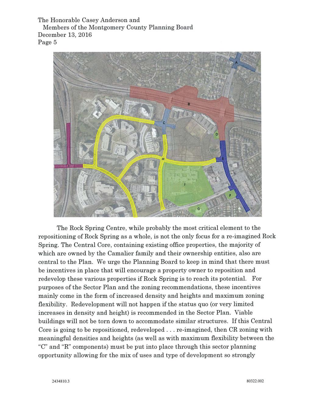
13 Montgomery County Planning Board Public Hearing Rock Spring Master Plan December 1, 2016 Testimony of Françoise M. Carrier on behalf of Democracy Associates Limited Partnership Good afternoon Chair Anderson and members of the Planning Board. For the record, I am Françoise Carrier. I am testifying on behalf of Democracy Associates Limited Partnership, owner of approximately 15 acres of land in the Rock Spring office park. The property is known as Democracy Center and is developed with three office buildings around a plaza, a small amount of surface parking supplementing 1,400 underground parking spaces, and a large, landscaped green area with a walking path and a basketball court. I m sure you are aware of the high vacancy rates in the Rock Spring office park. The long-term prospects for the office park are not viable under current conditions, lacking the transit access and mixed-use amenities that office tenants today find desirable. This master plan was undertaken principally to respond to this precarious situation. The vision set out in the current draft includes promoting greater amenity options and more of a mix of uses. However, the draft does not provide the zoning that would most effectively support this vision. The draft plan recommends leaving almost the entire Rock Spring office park in the EOF zone, which is primarily an employment zone. The draft does two things to try and promote more amenities and a greater mix of uses in the office park: it recommends a change in the EOF zone to provide more use flexibility, and it states that nearly all of the office park properties could be considered for rezoning to a mixed-use floating zone. These are positive steps, but in our view, they are not enough. The recommended change in the EOF zone increases flexibility, but it still artificially constrains the property owner s ability to respond to the market. Similarly, a recommendation for a mixed-use floating zone is helpful because it makes it more likely that a future rezoning application will be approved, but it places an extra layer of time-consuming and costly process in the way of mixed-use development. The fundamental question is whether this plan will apply zoning that will support mixed-use development, knowing that the plan will not be amended again for at least 20 years. Democracy Associates requests one of two approaches: either rezone its property to the CRT zone, or amend the EOF zone to permit any mix of uses approved by the Planning Board at site plan, provided that the applicable master plan recommends mixed-use development. In addition to zoning issues, Democracy Associates is concerned about the draft plan s recommendations for its large green space. The plan states... if the owner concurred, the Plan would encourage public access to this open space given the nearby residential development under construction at the EYA property; it is anticipated that residents may use this open space for recreation and dog walking. Democracy Associates incurred the expense of undergrounding most of its parking to create a private open space that serves as an important amenity for its office tenants. It is inappropriate
14 for a county master plan to suggest that one property owner should make its private open space open to the public to benefit another private development. We request removal from the plan of all references to this private open space being made open to the public, and in particular the plan's implied endorsement of its use by residents of the nearby townhouse development. The draft plan also recommends that if the property redevelops, the open space should be acquired by the Parks Department. If this possibility is of interest to the Planning Board, we would suggest discussion at a future work session of providing mixed use zoning for this property, with a higher density for the developable land in the event that the open space is dedicated to park use. Thank you very much. We look forward to working with you and your staff as the plan moves forward.
15
16
17
18
19
20
21
22

23
24
25
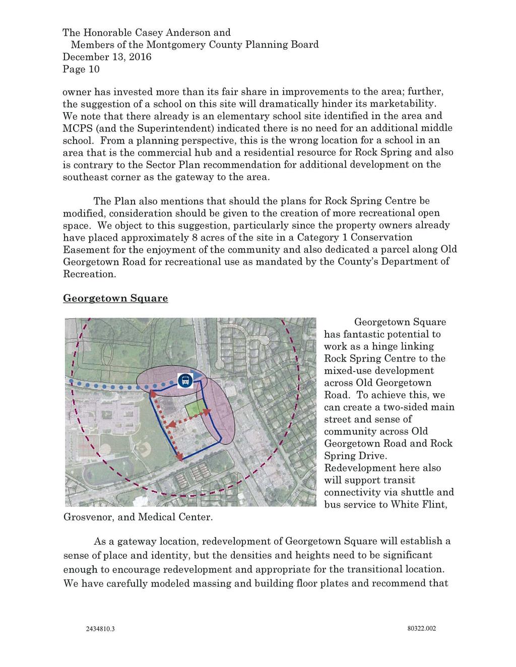
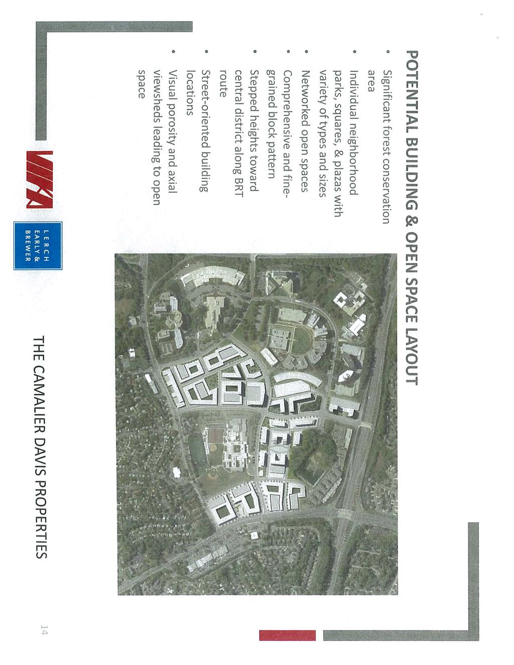
26

27
28

29
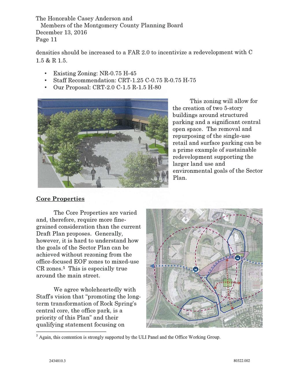
30
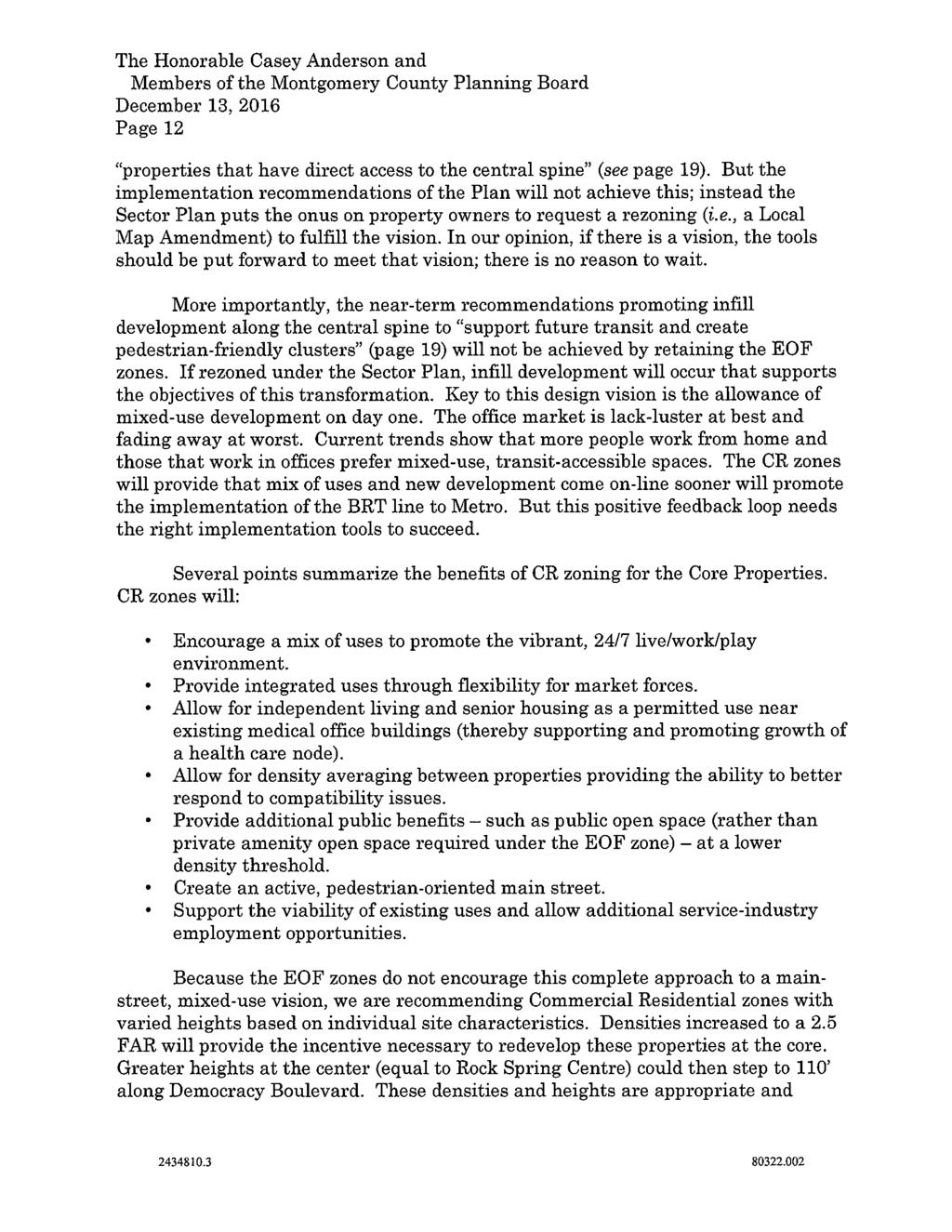
31
32
33
34
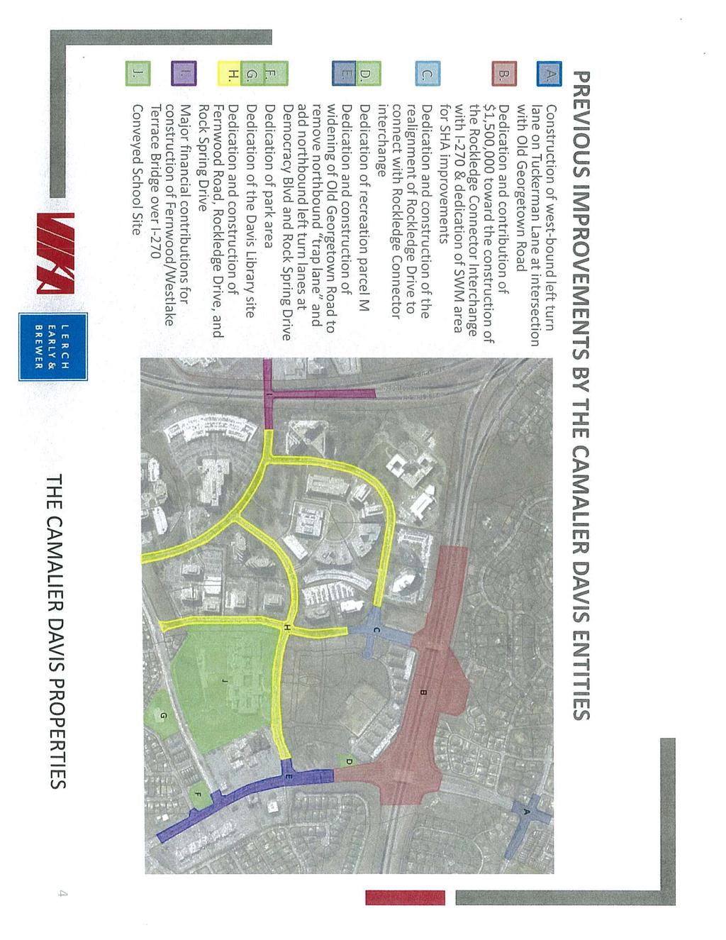
35
36
37
38
39
40
41
42
43
44
45
46


47

48
49
50
51
52
53
54
55
56
57
58 M E M O R A N D U M December 9, 2016 TO: FROM: SUBJECT: Greg Ossont, Deputy Director Department of General Services Christopher Conklin, P.E., Deputy Director for Policy Department of Transportation Rock Spring Master Plan MCDOT Comments Thank you for the opportunity to review the October 2016 Planning Board Public Hearing Draft of the Rock Spring Master Plan. MCDOT supports the vision of the plan but believe the plan in its current state needs some additional considerations. To highlight our most pressing points from the detailed page-by-page comments attached: 1) North Bethesda Transitway (NBT): The plan appears to state that the NBT will connect to Grosvenor Metro Station. As per the Countywide Transit Corridor Functional Master Plan we believe that Grosvenor should remain only 1 of 2 options with the other being White Flint until further analyses are completed. 2) LATR / TPAR Analyses: Provide 2016 LATR and 2012 TPAR Roadway analyses and findings. If both tests pass, this strengthens the case for the proposed road diets and can make implementation proceed more smoothly through their respective public processes. 3) Internal Superblock Streets: We believe that proposed internal streets within the superblocks should be treated as new streets, shown in Table 1 and Figure 17 accordingly and listed as being either public or private streets. Showing them in the plan will help guide new development in establishing the layouts and configurations of the streets, and across the area this can help provide a more unified network capable of dispersing traffic across a grid. 4) Cross-Section Standards: Provide the nearest cross-sections for each non-sha roadway segment in Table 1, as well as a list of any proposed changes to minimum rights-of-way. Where there is not a precise cross-section, provide the nearest cross-section and append the number with mod. Ideally, each modification should be accompanied by a note or footnote describing the intent of the modification.
59 5) I-270: We support the inclusion of the ramps between Fernwood Rd / Westlake Terrace and I-270 to the south. We also suggest that consideration be given toward reducing the radius of the ramp from westbound Democracy Blvd onto northbound I ) Funding Mechanism: Consider whether any special funding mechanism may be suitable for the plan area for NADMS-focused projects, such as transit services, road diets, Bikeshare, etc. Should you have any questions regarding our comments on the Rock Spring Master Plan, please feel free to contact me or Mr. Andrew Bossi, Senior Engineer, at CC:AB:kcf Attachments: detailed technical comments cc: Al Roshdieh, MCDOT Gary Erenrich, MCDOT Andrew Bossi, MCDOT Amy Donin, DGS 2
60 Agency Division Team Commenter MCDOT DO Commuter Services SB PDF Page # General MCDOT DO Devel Rvw GL 14,32 MCDOT DO Devel Rvw GL 18 Section Transportation & Connectivity MCDOT DO AB 23, 58 Connectivity MCDOT DO Devel Rvw GL 50 MCDOT DO AB 51 Goal 4 MCDOT DO AB Transit Network MCDOT DO AB, DB Transit Network MCDOT DO AB 56,69 Transit Network MCDOT DO Commuter Services SB 56 Transit Network MCDOT DO AB Roadway Network MCDOT DO Devel Rvw GL Roadway Network MCDOT DO AB Roadway Network MCDOT DO AB, RT 58 Roadway Network Comment Consider whether a special funding mechanism may be suitable for the Plan area for funding NADMS-focused projects, such as the Rock Spring Park Express Bus Service, North Bethesda Transitway capital or operations, road retrofits necessary to create a more bike- and ped-friendly environment, Bikeshare throughout the Plan area, and other components of a comprehensive TMD program (which could be jointly branded with the Activate Rock Spring initiative noted on p51). Significant frontage and off-site roadway treatments were required for the Westfield Montgomery Mall (plan numbers and ), including shared use path & bike lanes along Westlake Dr, and widened sidewalks along Westlake Ter. The Plan should acknowledge those projects and address the status of plan approval. 3rd bullet - Recommend revising the street name to Westlake Terrace for consistency with various maps (p51, and Table 1). Be mindful of the role of the most recent regulations regarding private streets. In the 1st bullet on p23, delete the phrase "public or private" so it reads "Expand the existing street network with new streets that are walkable and well connected." Regarding the midblock crosswalk on Rock Spring Dr at Walter Johnson HS - Significant discussion and infrastructure requirements were conditioned of the Avalon Bay developer at the site plan ( A) stage, including construction of a fence/wall in the median (to channel pedestrians to a proposed signalized intersection). The report should acknowledge this project and address the status of that plan approval. Need to identify missing ped/bike connections, as these should be reflected in the CIP listing (p69). While this bullet states that Figure 15 shows such connections as green links, note that Figure 15 does not appear to show either existing nor missing connections. Provide information the 2012 TPAR Transit test. While each metric is operational, these provide a good snapshot of Existing condtions & the needs as the plan area develops. Providing a map showing existing and proposed transit connections. Proposed BRT station areas should not be mere "dots on a map", but should be lengthened to provide a more informative indication of a transit station's length of ROW impacts. Note that as we do not currently have any detailed design for the Transitway, we must err on the side of caution and recommend more ROW-intensive median platform stations (similar to a linearshaped leaf, rather than a simple rectangle as would be the case with side platforms). It appears that this plan appears to assert that the North Bethesda Transitway will terminate at Grosvenor Metro Station rather than White Flint Metro Station. Please confirm. We urge that this remain only 1 of 2 options, as defined in the Countywide Transit Corridor Functional Master Plan. Consider expanding upon the 2nd to last paragraph to specify that not only are the unbuilt ramps onto southbound 270 spur intended to facilitate transit, but the recently built transit center was explicitly located at its present location to make use of these future connections. Consider whether the plan should propose reducing the radius of the ramp from westbound Democracy onto the northbound I-270 Spur. Consider how bus stops will be accommodated along separated bike paths, and how this may affect parking, buffers / SWM, and sidewalks. Note the recent discussion w/ Washington Adventist Hospital in White Oak, along Plum Orchard Dr, where shifting the curb lines was deemed to be an unnecessary expense versus eliminating onstreet parking. A preliminary working draft of this map showed a number of potential private street locations. We believe that some of these roadways have merit in helping to break up the superblocks and that they should be shown on this map as new streets. These streets may be listed as public or private (depending on criteria established by the subdivision regulations). By showing these streets we can more comprehensively lay these streets out in a rational and unified manner so that they may best serve the needs of the area, easing the development review process as layouts and configurations for the streets are established. Provide 2016 LATR and 2012 TPAR Roadway analyses and findings. If both tests pass, this strengthens the case for the proposed road diets and can make implementation proceed more smoothly through their respective public processes. If either of the tests fail, it is an indication that more evaluation and infrastructure may be necessary to achieve the vision of the plan, or acts to raise awareness if the plan is approved with acknowledgment of potential impacts to congestion. MCDOT DO Devel Rvw RT 58 Roadway Network Confirm that any transportation analyses are not exclusively based on Existing conditions, but noting the purported vacancy rates for the area: transportation analyses should account for the unused potential of underutilized properties under Existing conditions. MCDOT DO Devel Rvw GL 58 Roadway Network Clarify if the analysis' findings are dependent on implementation of the North Bethesda Transitway. That is: can some/all lane diets occur prior to operation of the transitway or must the transitway come first? MCDOT DO Devel Rvw GL 58 Roadway Network More clearly delineate I-270. MCDOT DO AB 58 Roadway Network Show the private street connection proposed between B-7 and B-8 (as noted on p34). Note, however, that as this connects the termini of two existing public streets we believe this street should be public. If private, B-7 and B-8 will each need public turnarounds. MCDOT DO AB 59 Roadway Network Edit the 2nd part of the 1st sentence to read "...including reconstructing the curbs and accompanying drainage system" MCDOT DO AB 59 Roadway Network In Cross-Section 2, Consider how the 5 ft buffer beside the parking lane may be designed & used as a public space. If separated from the parking lane by a white line it is possible that bicyclists may use this as a bike lane, despite the presence of the cycle track and risk of the passenger-side door zone. MCDOT DO AB 59 Roadway Network If legibility can be preserved, it may be helpful for the common 80 ft ROW between the two cross-sections to align vertically with each other. MCDOT DO Devel Rvw RT 59 Roadway Network Cross-Section 1 has 5 ft buffers and an 8 ft median between the roadway and bikeway. Note that buffers of between 4 to 6 ft are restricted to small trees only, and such small widths will not be able to adequately function as stormwater management facilities. Furthermore, the cross-section should give consideration as to where utilities would be located.
61 MCDOT DO AB, GL Roadway Network Provide the nearest cross-sections for each non-sha roadway segment and denote the number of travel lanes intended. As separated bike lanes and shared use paths are not included in any of the approved Context Sensitive Road Design Standards, it is anticipated that there will not be an exact CSRDS for each roadway. Where there is not a precise cross-section, provide the nearest cross-section and append the number with mod. Ideally, each modification should be accompanied by a note or footnote describing the intent of the modification. Alternately, providing cross-sections either in the main document or in the appendix will help establish intention &/or act as proof of concept. In general, it is our preference that dimensioned cross-sections be located in the Appendix, as providing dimensioned cross-sections in the plan itself can be interpreted as rigidly fixing those dimensions as requirements, limiting flexibility should standards change. Referencing road design standards can be a useful method of quickly identifying a plan s intent with the ROW, be it for car lanes, parking, bike lanes, sidewalks, landscaping, etc. (especially helpful where stipulated ROW is greater than what is called for in a standard). MCDOT DO AB 60 Roadway Network There are two instances of "West Lake" rather than what appears to be the convention of "Westlake" MCDOT DO AB 60 Roadway Network Consider including I-270 in Table 1, with an associated ROW requirement. MCDOT DO AB 61 re: Protected Intersections - Note that additional ROW may come in the form of larger intersection/corner truncations. MCDOT DO AB 61 Roadway Network In the footnote *, include "transit stations" as a potential need for additional ROW. MCDOT DO Devel Rvw GL 61 Roadway Network Clarify why P-5 and P-8 are included in the table if they are located outside of the Plan area. However, if they are going to be included in the table, they should also be included in Figure 17 on page 58. MCDOT DO AB 62 Roadway Network At the end of the 2nd paragraph consider noting that this Bike/Ped Priority Area is not currently state-designated. MCDOT DO Commuter Services SB 62 Bicycle Network Consider strengthing the paragraph on Capital Bikeshare stations. The Plan could recommend that major new projects be required to pay for Bikeshare stations and operating costs, and that others will be required to contribute to the cost of the network on a proportional basis. specific siting will be dependent upon each project's plans and will need to be determined by the operator of the bikeshare network (MCDOT). MCDOT DO Commuter Services SB 62 Bicycle Network Be mindful that while the Plan states that Bikeshare will help connect the Plan area with "all of the residential neighborhoods in the area", unless a funding mechanism is identified it is unlikely that all the surrounding communities (particularly those consisting primarily of SFDUs) will have Bikeshare within a short distance. Consider rephrasing that it will connect "many of the higher density residential communities in the area" MCDOT DO AB 63 Bicycle Network Consider the neet to show SR-36, as designating Shared Roadways offers no functional need other than for wayfinding purposes. MCDOT DO AB 63 Bicycle Network Consider whether there is a need for improved bicycle facilities between the plan area and Grosvenor Metro Station. While it would be outside the plan area, it may be important to reference any needs for improved facilities even if this plan does not explicitly propose them. MCDOT DO AB 63 Bicycle Network Include a Bicycle Level of Stress map in the appendix, showing Existing vs Build-Out conditions. MCDOT DO AB 65 Pedestrian Network Note that exclusive phases for bicycles and pedestrians may affect the overall capacity of an intersection. To the extent feasible, this should be reflected (or otherwise acknowledged) in any LATR analyses. MCDOT DO Commuter The Plan states that the TMD spans only to the east of the 270 Spur, but the TMD includes the Mall. We suggest SB 66 TDM Services including a map showing the TMD, as well as any other applicable policy-oriented areas. MCDOT DO The Plan discusses only staff assistance to employers (and implicitly employees), citing 39% NADMS goal for Commuter SB 66 TDM employees. However, the TMD also provides assistance to residents and property owners of multiunit residential Services projects, including an NADMS goal for residentially-based commuting, as well. As was done with Bethesda, we urge that a listing of CIP Projects be provided, along with identified lead stakeholders. We noted the following transportation projects, though caution that this may not be a comprehensive list: - p51, Goal 3 - ped/bike connections across 270 spur along Westlake Ter - p51, Goal 4 - missing ped/bike connections (need to be identified) - p57 - HOV Ramps from Fernwood Rd to I-270 Spur SB. - p56 - North Bethesda Transitway between Grosvenor Metro & Montgomery Mall - p57 - Express Bus between North Bethesda, Montgomery Mall, and Tysons - p Reclassification from Arterial to Business (B-1, B-2, B-3) (and associated long-term as well as interim treatments) (and impacts to the Westlake bridge over the I-270 Spur) MCDOT DO AB 69 - p Reclassification from Unclassified to Business (B-4, B-5, B-6, B-7, B-8) - p Reclassification from Primary Res to Minor Arterial for MA-5 - p B-6 (to be built by redevelopment) - p62 - Bikeshare - p All unbuilt bikeways (cycletracks may be cross-referenced with reclassification projects resulting from p57-61) - p65 - BiPPA Costs associated with Ped Upgrades, Retrofits, ADA Treatments, Protected Intersections, Signal Reconstructions & Retrofits, Signal Timing Studies - p66 - Removal of R-turn channelization at: Democracy/Bells Mill, Democracy/Rockledge Dr, Democracy/Fernwood, Democracy/Westlake, 187/Rock Spring, Rockledge/Rockledge - p66 - Rock Walter Johnson HS Midblock Crosswalk - p66 - County costs toward the TDM
62 DEP Comments on Rock Spring Master Plan October 2016 Public Hearing Draft 1. General: Introduction focuses on background and history and office market challenges, but lacks any mention of stormwater or sustainability opportunities and challenges. 2. Bottom of Page 11: Challenges Recommend adding lack of green infrastructure and state of the art stormwater management to the list. 3. Page 13, Figure 6 Suggest calling these projects future projects rather than pipeline projects, or clarify this term better somewhere in the text. 4. Page 35, Chapter 3 Recommend adding a figure to show the watershed and drainage areas. The planned stream restoration of the Grosvenor Luxmanor Tributary in fall 2017 should be mentioned. This stream receives drainage from the Rock Spring master plan area and efforts to control and treat stormwater will augment the County s downstream restoration efforts. More info: 5. Page 36-37, Goals and Objectives This section lists 11 objectives that should be addressed in this Plan. However, most of the objectives (e.g. 1, 2, 4, 5, and 6) do not appear to be addressed in the recommendations or anywhere else in the Plan. 6. Page 38, Overall Recommendations The second bullet states Encourage green features (softscaping) in required open space areas and the public realm. Suggest more specific focus on green infrastructure and low impact development (LID). The same aesthetic can be achieved with the added benefit of improved stormwater management. 7. Page 38, Topic Specific Recommendations, Water Quality Suggest adding bullets: o Encourage use of green infrastructure and LID stormwater management in private open areas, public areas, and along roadways to improve water quality to receiving streams. o Recommend adding to the quality and quantity of any existing stream channel buffer areas. Examine channel restoration and/or stream daylighting opportunities. o Consider additional LID opportunities at Walter Johnson High School 8. Page 58, Transportation and Connectivity section Suggest adding green streets/ LID features such as bioswales and rain gardens along reconstructed roadways. December 1, 2016
63 Donin, Amy From: Sent: To: Cc: Subject: Bourne, Jeffrey Tuesday, November 08, :47 AM Donin, Amy; Ossont, Greg Albornoz, Gabriel; Kaarid, William; Riley, Robin Re: Comments needed - Rock Spring Master Plan Recreation Rock Spring Comments, 11/8/16 Review of the document finds accurate depiction of the park & recreation needs w/i the plan vicinity. Community Recreation services will be provided by the future County development of the North Bethesda Regional Recreation Center which will include the KSAC and a region serving community recreation facility including continuation of the racquetball and dry land training facilities. This facility will be conveniently located at Wall Park very near the Metro. One additional note should address the extreme importance of adding parks & open space if the larger Rock Spring area undergoes redevelopment to provide significant med/high density residential construction. Jeffrey A. Bourne Chief, Division of Facilities & Capital Programs Montgomery County Recreation 4010 Randolph Rd. Silver Spring, MD O jeffrey.bourne@montgomerycountymd.gov
Rock Spring Master Plan Community Meeting #8: Preliminary Recommendations
 Rock Spring Master Plan Community Meeting #8: Preliminary Recommendations July 18, 2016 Ι Walter Johnson High School Andrea Gilles, andrea.gilles@montgomeryplanning.org Ι www.montgomeryplanning.org/community/rockspring/
Rock Spring Master Plan Community Meeting #6: Land Use + Transportation Forecasts
 Rock Spring Master Plan Community Meeting #6: Land Use + Transportation Forecasts May 23, 2016 Ι Walter Johnson High School Andrea Gilles, andrea.gilles@montgomeryplanning.org Ι www.montgomeryplanning.org/community/rockspring/
MONTGOMERY COUNTY PLANNING DEPARTMENT
 MONTGOMERY COUNTY PLANNING DEPARTMENT THE MARYLAND-NATIONAL CAPITAL PARK AND PLANNING COMMISSION Ourisman Ford at Montgomery Mall, Sketch Plan No. 320170100 MCPB Item No. Date: 11-30-17 LS Lori Shirley,
MONTGOMERY COUNTY PLANNING DEPARTMENT
 MONTGOMERY COUNTY PLANNING DEPARTMENT THE MARYLAND-NATIONAL CAPITAL PARK AND PLANNING COMMISSION Ashburton Elementary School Addition, Mandatory Referral, MR2018009 MCPB Item No. Date: 02-15-18 Troy Leftwich,
At first Work Session on October 22, At second Work Session on November 19, At third Work Session on December 3, 2015
 At first Work Session on October 22, 2015 Staff Reviewed Infrastructure: Transportation Capacity School Capacity Willett Branch Proposed Staging Language At second Work Session on November 19, 2015 Land
S C O P E O F W O R K A P R I L
 white flint 2 sector plan S C O P E O F W O R K A P R I L 2 0 1 2 MONTGOMERY COUNTY PLANNING DEPARTMENT M-NCPPC MontgomeryPlanning.org 1 white flint 2 sector plan Scope of Work abstract This scope of work
master plan of highways bus rapid transit amendment
 Scope of Work master plan of highways bus rapid transit amendment September 2011 Montgomery County Planning Department M-NCPPC MontgomeryPlanning.org 1 Scope of Work master plan of highways bus rapid transit
MONTGOMERY COUNTY PLANNING DEPARTMENT THE MARYLAND-NATIONAL CAPITAL PARK AND PLANNING COMMISSION
 MONTGOMERY COUNTY PLANNING DEPARTMENT THE MARYLAND-NATIONAL CAPITAL PARK AND PLANNING COMMISSION MCPB Item No. Date: 05/12/2016 North Bethesda Conference Center Parking Structure, Mandatory Referral No.
MONTGOMERY COUNTY PLANNING DEPARTMENT THE MARYLAND-NATIONAL CAPITAL PARK AND PLANNING COMMISSION
 MONTGOMERY COUNTY PLANNING DEPARTMENT THE MARYLAND-NATIONAL CAPITAL PARK AND PLANNING COMMISSION White Flint 2 Sector Plan: Briefing and Preliminary Staff Recommendations MCPB Item No. Date: 07/28/2016
MONTGOMERY COUNTY PLANNING DEPARTMENT
 MONTGOMERY COUNTY PLANNING DEPARTMENT THE MARYLAND-NATIONAL CAPITAL PARK AND PLANNING COMMISSION MCPB Item No.: Date: 5-03-18 Pike and Rose, Phase I: Site Plan Amendment No. 82012002D Rhoda Hersson-Ringskog,
MONTGOMERY COUNTY PLANNING DEPARTMENT
 MONTGOMERY COUNTY PLANNING DEPARTMENT THE MARYLAND-NATIONAL CAPITAL PARK AND PLANNING COMMISSION Rock Spring Master Plan Public Hearing Draft: Worksession #7 MCPB Item No. Date: 3-30-17 Nancy Sturgeon,
MONTGOMERY COUNTY PLANNING DEPARTMENT THE MARYLAND-NATIONAL CAPITAL PARK AND PLANNING COMMISSION
 MONTGOMERY COUNTY PLANNING DEPARTMENT THE MARYLAND-NATIONAL CAPITAL PARK AND PLANNING COMMISSION MCPB Item No. Date10/25/12 Sketch Plan No. 32012004, White Flint Mall Redevelopment Nkosi Yearwood, Senior
Public input has been an important part of the plan development process.
 Lakewood s Comprehensive Plan recognizes that transportation helps shape the community, and that the way the community provides for the safe and efficient movement of people affects the character of the
Preliminary Recommendations Tk Takoma/Langley Crossroads Sector Plan
 Preliminary Recommendations Tk Takoma/Langley Crossroads Sector Plan Vision is to achieve a Transit Oriented, pedestrian friendly Community that Celebrates and builds upon the cultural Diversity of the
The subject site plan amendment proposes the following revisions to the approved site plan:
 PROPOSED AMENDMENT The subject site plan amendment proposes the following revisions to the approved site plan: 1. The building footprint was modified to accommodate the revised architectural design. 2.
MONTGOMERY COUNTY PLANNING DEPARTMENT THE MARYLAND-NATIONAL CAPITAL PARK AND PLANNING COMMISSION
 MONTGOMERY COUNTY PLANNING DEPARTMENT THE MARYLAND-NATIONAL CAPITAL PARK AND PLANNING COMMISSION MCPB Item No. 6 Date: 7.22.13 Bethesda Purple Line Station Minor Master Plan Amendment, Scope of Work Elza
Executive Summary. NY 7 / NY 2 Corridor
 Executive Summary NY 7 / NY 2 Corridor Transportation and Land Use Study December 2005 Prepared for: Town of Colonie Capital District Transportation Committee Prepared by: Introduction: Land use decisions
CONTENTS BACKGROUND AND CONTEXT... 3 Plan Area... 3 History... 3 Previous Planning Initiatives... 4 PLANNING FRAMEWORK... 5 Countywide Transit
 CONTENTS BACKGROUND AND CONTEXT... 3 Plan Area... 3 History... 3 Previous Planning Initiatives... 4 PLANNING FRAMEWORK... 5 Countywide Transit Corridors Functional Master Plan... 5 Veirs Mill Road Bus
MONTGOMERY COUNTY PLANNING DEPARTMENT THE MARYLAND-NATIONAL CAPITAL PARK AND PLANNING COMMISSION
 MONTGOMERY COUNTY PLANNING DEPARTMENT THE MARYLAND-NATIONAL CAPITAL PARK AND PLANNING COMMISSION Rock Spring Master Plan: Briefing and Preliminary Staff Recommendations MCPB Item No. Date: 07/28/2016 Andrea
The Illinois Department of Transportation and Lake County Division of Transportation. Route 173, including the Millburn Bypass
 The Illinois Department of Transportation and Lake County Division of Transportation welcome you to this Public Hearing for U.S. Route 45 from Illinois Route 132 to Illinois Route 173, including the Millburn
Joint Public Hearing. Preliminary Subregion 5 Master Plan and Proposed Sectional Map Amendment
 Preliminary Subregion 5 Master Plan and Proposed Sectional Map Amendment Joint Public Hearing April 11, 2013 Council Hearing Room Upper Marlboro 7:00 pm His Lordship s Kindness (Clinton) Presentation Overview
MONTGOMERY COUNTY PLANNING DEPARTMENT THE MARYLAND-NATIONAL CAPITAL PARK AND PLANNING COMMISSION
 MONTGOMERY COUNTY PLANNING DEPARTMENT THE MARYLAND-NATIONAL CAPITAL PARK AND PLANNING COMMISSION Long Branch Sector Plan, Worksession 5 MCPB Item No. Date: 4.11.13 Melissa Williams, Senior Planner, Area
Gold Line Bus Rapid Transit Transit Oriented Development (BRTOD) Helmo Station Area Plan
 Helmo Station Area Plan") Appendix F Gold Line Bus Rapid Transit Transit Oriented Development (BRTOD) Helmo Station Area Plan Introduction and Purpose of the Plan The Gold Line Bus Rapid Transit facility is an eleven-mile dedicated
Appendix F Gold Line Bus Rapid Transit Transit Oriented Development (BRTOD) Helmo Station Area Plan Introduction and Purpose of the Plan The Gold Line Bus Rapid Transit facility is an eleven-mile dedicated
Preliminary Recommendations
 Preliminary Recommendations Plan Area 2 Plan Context White Flint 2 2010 White Flint Sector Plan 2009 Twinbrook Sector Plan 3 Plan Context 4 Plan Context White Flint Residential Non-Residential Sector Plan
INTRODUCTION. Figure 1: Master Plan Area Boundary
 CONTENTS Introduction Planning Framework Background and Context Development Activity Purpose of the Plan Issues to be Addressed Land Uses and Urban Design Transportation and Connectivity Community Facilities
Public Meeting: July 11, 2016
 Public Meeting: July 11, 2016 MONTGOMERY COUNTY PLANNING DEPARTMENT Maryland-National Capital Park and Planning Commission Tonight s Agenda Preliminary Recommendations Background and Context 2009 Twinbrook
MEMORANDUM BACKGROUND. lcouncilmembers should bring their copy of the Plan to the meeting.i. AGENDA ITEM #l0a November 28, 2017.
 AGENDA ITEM #l0a November 28, 2017 Worksession MEMORANDUM November 22, 2017 TO: FROM: SUBJECT: County Council ~ Marlene Michaelson, Senior Legislative Analyst Grosvenor-Strathmore Metro Area Minor Master
Transportation. Strategies for Action
 Transportation A major priority for the Overlake Neighborhood is to develop a multimodal transportation system. To achieve this system, a balance has to be found among travel, circulation and access needs;
Planning Board Briefing
 Planning Board Briefing Why Now? The Sector Plan Implementation Chapter States: Before Stage 1 begins, the following must occur: Approval of the Sectional Map Amendment. Approval of the Greater Lyttonsville
Northwest Rail Corridor and US 36 BRT Development Oriented Transit Analysis 4.4 STATION AREA FINDINGS
 4.4 STATION AREA FINDINGS Each station is different, and each one requires a separate set of recommendations based on the vision for the site. This section outlines an initial TOD strategy and recommendations
MONTGOMERY COUNTY PLANNING DEPARTMENT THE MARYLAND-NATIONAL CAPITAL PARK AND PLANNING COMMISSION
 MONTGOMERY COUNTY PLANNING DEPARTMENT THE MARYLAND-NATIONAL CAPITAL PARK AND PLANNING COMMISSION MCPB Item No. Date: 12-10-15 Leisure World Clubhouse II Addition Fitness Center, Limited Site Plan Amendment
County Council Presentation. White Oak Science Gateway Planning Board Draft Master Plan June 17, 2014
 County Council Presentation White Oak Science Gateway Planning Board Draft Master Plan June 17, 2014 http://montgomeryplanning.org/community/wosg/index.shtm Nancy Sturgeon, Lead Planner www.nancy.sturgeon@montgomeryplanning.org
Seneca Meadows. Block 4 Locate office, technology, and medical development adjacent to I Screen views of garage structures from I-270.
 Seneca Meadows Seneca Meadows has an industrial park in its southern end and a mixed-use employment area planned for the north end. The district benefits from extensive I-270 visibility, stream valley
Community Meeting November 18, 2015
 Top Concerns We ve Heard Use of Urban Road Code Total number of units and effect on schools and transportation Land swaps with Parks Department: how do these benefit the community? Zoning classifications:
MONTGOMERY COUNTY PLANNING DEPARTMENT THE MARYLAND-NATIONAL CAPITAL PARK AND PLANNING COMMISSION
 MONTGOMERY COUNTY PLANNING DEPARTMENT THE MARYLAND-NATIONAL CAPITAL PARK AND PLANNING COMMISSION Staff Report: Sketch Plan #320110010, Mid-Pike Plaza ITEM #: MCPB HEARING DATE: January 20, 2011 REPORT
DRAFT. October Wheaton. Design Guidelines
 October 2011 DRAFT Wheaton Design Guidelines 2 Draft - Design Guidelines - Wheaton Sector Plan Contents 04 Section 1: Introduction 06 Section 2: Context 08 Section 3: Design Guidelines 09 Goal 1: Create
9 th Street Sub Area Plan
 9 th Street Sub Area Plan In the 1990 s, when the Township prepared the last Master Plan, the 9 th Street corridor was studied as part of a larger 9 th Street Focus Area that included the West Main Street
MONTGOMERY COUNTY PLANNING DEPARTMENT THE MARYLAND-NATIONAL CAPITAL PARK AND PLANNING COMMISSION
 MONTGOMERY COUNTY PLANNING DEPARTMENT THE MARYLAND-NATIONAL CAPITAL PARK AND PLANNING COMMISSION MCPB Item No. Date: 1/26/12 Hanover Shady Grove, Sketch Plan 320120020 Joshua Sloan, Coordinator, Joshua.Sloan@MontgomeryPlanning.org,
Cobb County Design Guidelines Mableton Parkway & Veterans Memorial Highway Community Design Workshop January 12, 2017
 Community Design Workshop January 12, 2017 Agenda Opening Remarks / Introductions Scope of Work Existing Conditions Key Issues / Opportunities VPS Summary Draft Vision & Goal Statement Implementation Concepts
CITY OF CHARLOTTESVILLE, VIRGINIA CITY COUNCIL AGENDA
 CITY OF CHARLOTTESVILLE, VIRGINIA CITY COUNCIL AGENDA Agenda Date: December 16, 2013 Action Required: Adoption of Resolution Presenter: Staff Contacts: Title: James E. Tolbert, AICP, Director of NDS James
Mini Technical Assistance Panel. Rock Spring Park
 Mini Technical Assistance Panel Rock Spring Park May 22, 2013 The Team Jason Bonnet, Forest City Washington Matthew Flis, Town of Vienna William Herbig, National Capital Planning Commission Sophie Lambert,
Town Center. Block 5 Existing multifamily residential units are expected to remain.
 Area Guidelines Germantown s districts should be developed as distinct communities with unique features that are supported through the guidelines. The guidelines not only help distinguish these districts
Implementation Guide Comprehensive Plan City of Allen
 Implementation Guide 2030 Comprehensive Plan City of Allen DRAFT 2015 Implementation Guide Allen 2030 Comprehensive Plan INTRODUCTION The Comprehensive Plan serves as a guide for the growth and development
Status Report: MD 355 Project
 Status Report: MD 355 Project OCTOBER 2006 M-NCPPC MONTGOMERY COUNTY PLANNING DEPARTMENT Summary of Community Comments, and break to the Results of the MD 355 Participation Session Brookside Gardens -
Urban Planning and Land Use
 Urban Planning and Land Use 701 North 7 th Street, Room 423 Phone: (913) 573-5750 Kansas City, Kansas 66101 Fax: (913) 573-5796 Email: planninginfo@wycokck.org www.wycokck.org/planning To: From: City Planning
MONTGOMERY COUNTY PLANNING DEPARTMENT THE MARYLAND-NATIONAL CAPITAL PARK AND PLANNING COMMISSION
 MONTGOMERY COUNTY PLANNING DEPARTMENT THE MARYLAND-NATIONAL CAPITAL PARK AND PLANNING COMMISSION MCPB Item No. Date: 1/15/2015 Bethesda North Marriott Hotel and Conference Center: Limited Site Plan Amendment
MONTGOMERY COUNTY PLANNING DEPARTMENT THE MARYLAND-NATIONAL CAPITAL PARK AND PLANNING COMMISSION
 MONTGOMERY COUNTY PLANNING DEPARTMENT THE MARYLAND-NATIONAL CAPITAL PARK AND PLANNING COMMISSION MCPB Item No. 8 Date: 12-15-16 Montgomery Village Center Sketch Plan No. 320170020 TL Troy Leftwich, Senior
MONTGOMERY COUNTY METRO STATION AREA DESIGN CHARRETTE
 MONTGOMERY COUNTY METRO STATION AREA DESIGN CHARRETTE Shady Grove Metro Station Area Charrette Closing Presentation October 25-28, 2000 MONTGOMERY COUNTY, MD M-NCPPC Design Collective, Inc. Architects
CLACKAMAS COUNTY BOARD OF COMMISSIONERS 2051 Kaen Road, Oregon City BCC Hearing Room - 4th Floor. LAND USE HEARING October 3, :30 AM
 CLACKAMAS COUNTY PLANNING AND ZONING DIVISION DEPARTMENT OF TRANSPORTATION AND DEVELOPMENT DEVELOPMENT SERVICES BUILDING 150 BEAVERCREEK ROAD OREGON CITY, OR 97045 503-742-4500 ZONINGINFO@CLACKAMAS.US
MONTGOMERY COUNTY PLANNING DEPARTMENT THE MARYLAND NATIONAL CAPITAL PARK AND PLANNING COMMISSION
 MONTGOMERY COUNTY PLANNING DEPARTMENT THE MARYLAND NATIONAL CAPITAL PARK AND PLANNING COMMISSION Bethesda Downtown Sector Plan, Work Session #1 MCPB Item No. Date: 7-20-15 Leslye Howerton, Planner Coordinator,
Local Growth Planning in North Central Green Line Communities
 2018 April 30 Page 1 of 6 EXECUTIVE SUMMARY This report outlines a high-level scope for local growth planning for north central Green Line communities. The catalyst for this review is the significant investments
Official Plan Review: Draft Built Form Policies
 PG.30.1 REPORT FOR ACTION Official Plan Review: Draft Built Form Policies Date: May 15, 2018 To: Planning and Growth Management Committee From: Chief Planner and Executive Director, City Planning Division
Proposed Comprehensive Plan Strategies DRAFT for discussion June 28, 2017
 Proposed Comprehensive Plan Strategies DRAFT for discussion June 28, 2017 Land Use Rural Areas Refine the Farm and Forest area (FF) Update FF boundaries to account for existing lots less than five acres
Silver Line CPAM UPDATE. Transportation and Land Use Committee October 14, 2016
 Silver Line CPAM UPDATE Transportation and Land Use Committee October 14, 2016 Purpose Recap Project History and Map Changes Provide Overview of CPAM Components Discuss Transportation Impacts Discuss Fiscal
South Davis County COMMUNITY SPOTLIGHT
 South Davis County COMMUNITY SPOTLIGHT Davis/SLC Community Connector Bus Rapid Transit line connecting SLC & Davis County RTP Phase 1 Project Generate 3,100 average weekday riders Relieve congestion on
Citizen Comment Staff Response Staff Recommended Revision Planning Committee
 Citizen Comment Staff Response Staff Recommended Revision Planning Committee Area No. 1: Owner desires retail land uses. Area No. 1a: Owner of two small parcels adjacent to Area No. 1 desires retail land
MONTGOMERY COUNTY PLANNING DEPARTMENT THE MARYLAND-NATIONAL CAPITAL PARK AND PLANNING COMMISSION
 MONTGOMERY COUNTY PLANNING DEPARTMENT THE MARYLAND-NATIONAL CAPITAL PARK AND PLANNING COMMISSION MCPB Item No. 7 Date: 2-28-13 Purple Line Briefing David Anspacher, Senior Planner, david.anspacher@montgomeryplanning.org,
Westwood Shopping Center Sketch Plan, Plan # February 23, 2017 Item # 9
 Westwood Shopping Center Sketch Plan, Plan # 320170010 February 23, 2017 Item # 9 Westwood II Site 64,111 s.f. Manor Care site: vacant two story building HOC-Westwood Towers, 15 story tower To be considered
MONTGOMERY COUNTY PLANNING DEPARTMENT THE MARYLAND-NATIONAL CAPITAL PARK AND PLANNING COMMISSION
 MONTGOMERY COUNTY PLANNING DEPARTMENT THE MARYLAND-NATIONAL CAPITAL PARK AND PLANNING COMMISSION MCPB Item No. Date: 11-16-17 Hillandale Gateway, Sketch Plan, 320180020 Summary Lori Shirley, Planner Coordinator,
North Fair Oaks Community Plan Summary and Information
 North Fair Oaks Community Plan Summary and Information WHAT IS THE NORTH FAIR OAKS COMMUNITY PLAN? The North Fair Oaks Community Plan is part of the San Mateo County General Plan, and establishes policies
MONTGOMERY COUNTY PLANNING DEPARTMENT THE MARYLAND-NATIONAL CAPITAL PARK AND PLANNING COMMISSION
 MONTGOMERY COUNTY PLANNING DEPARTMENT THE MARYLAND-NATIONAL CAPITAL PARK AND PLANNING COMMISSION MCPB Item No. Date: 6/30/2016 Washington Adventist Hospital, Site Plan Amendment No. 82008021E Michael Brown,
LAND USE AMENDMENT DOWNTOWN COMMERCIAL CORE (WARD 7) MACLEOD TRAIL SE AND 5 AVENUE SE BYLAW 254D2017
 MACLEOD TRAIL SE AND 5 AVENUE SE BYLAW 254D2017") Page 1 of 10 EXECUTIVE SUMMARY This Land Use Amendment application seeks to redesignate a full downtown block (currently the YWCA site) from a Direct Control based on the CM-2 District (Land Use Bylaw
Page 1 of 10 EXECUTIVE SUMMARY This Land Use Amendment application seeks to redesignate a full downtown block (currently the YWCA site) from a Direct Control based on the CM-2 District (Land Use Bylaw
ASPEN HILL Minor Master Plan Amendment
 ASPEN HILL Minor Master Plan Amendment Worksession #3 Planning Board Agenda Item #5 MONTGOMERY COUNTY PLANNING DEPARTMENT Maryland-National Capital Park and Planning Commission Area 2 Planning November
TIRZ 17/Redevelopment Authority Capital Improvements Plan Projects
 Gessner Widening: T-1701 What: Widen the road from a six-lane divided boulevard to an eight-lane divided boulevard street section, increase turn lanes, update traffic signal system, improve drainage by
TRANSPORTATION ELEMENT
 TRANSPORTATION ELEMENT GOAL I: To create and maintain a safe, efficient and aesthetic transportation system that encourages multi-modal transportation and promotes the mobility strategies of the Ocala
Hockessin Community Redevelopment Plan
 Hockessin Community Redevelopment Plan 3.1 Introduction The Community Redevelopment Plan for the Village of Hockessin is the result of the people s vision for a distinct village center that serves as the
The transportation system in a community is an
 7 TRANSPORTATION The transportation system in a community is an important factor contributing to the quality of life of the residents. Without a sound transportation system to bring both goods and patrons
38 Queen s University Campus Master Plan Part 1
 38 Queen s University Campus Master Plan Part 1 46 The Campus at the City Scale Chapter 4 The Campus at the City Scale 39 Queen s is an urban University centrally located in Kingston. Decisions made by
MONTGOMERY COUNTY PLANNING DEPARTMENT THE MARYLAND NATIONAL CAPITAL PARK AND PLANNING COMMISSION
 MONTGOMERY COUNTY PLANNING DEPARTMENT THE MARYLAND NATIONAL CAPITAL PARK AND PLANNING COMMISSION Bethesda Downtown Sector Plan, Work Session #8 MCPB Item No.8 Date: 02-25-16 Leslye Howerton, Planner Coordinator,
Town Center (part of the Comprehensive Plan)
") Town Center (part of the Comprehensive Plan) Mercer Island Town Center Looking North (2014) In 1994, a year-long process culminated in a set of design guidelines and code requirements for the Town Center
Town Center (part of the Comprehensive Plan) Mercer Island Town Center Looking North (2014) In 1994, a year-long process culminated in a set of design guidelines and code requirements for the Town Center
Project Overview. Get Involved. Public Information Meeting. Contact Information
 Get Involved VDOT representatives will review and evaluate information received as a result of this meeting. Please fill out the comment sheet provided in this brochure if you have any comments or questions.
TRANSPORTATION ELEMENT GOALS, OBJECTIVES, AND POLICIES
 TRANSPORTATION ELEMENT GOALS, OBJECTIVES, AND POLICIES GOAL 2 The City shall provide a safe, convenient, effective, and energy efficient multimodal transportation system which is coordinated with the Future
CITY OF PUYALLUP. Background. Development Services
 CITY OF PUYALLUP Development Services 333 South Meridian Puyallup WA 98371 To: City Council From: Katie Baker, AICP, Planning Division Re: South Hill Neighborhood Plan Adoption Date: (Meeting date: February
City of Bristol Route 6 Corridor Implementation Program
 City of Bristol Route 6 Corridor Implementation Program FITZGERALD & HALLIDAY, INC. Innovative Planning, Better Communities June 2017 Route 6 Corridor Plan IMPLEMENTATION PROGRAM The following Implementation
SECTION 4(f) DE MINIMIS DOCUMENTATION
 DE MINIMIS DOCUMENTATION") SECTION 4(f) DE MINIMIS DOCUMENTATION Illinois Route 60/83 IL 176 to the intersection of IL 60 (Townline Road) Lake County P-91-084-07 Mundelein Park and Recreation District Project Limit SECTION 4(f)
SECTION 4(f) DE MINIMIS DOCUMENTATION Illinois Route 60/83 IL 176 to the intersection of IL 60 (Townline Road) Lake County P-91-084-07 Mundelein Park and Recreation District Project Limit SECTION 4(f)
COMMUNITY DESIGN. GOAL: Create livable and attractive communities. Intent
 COMMUNITY DESIGN Intent An attractive, well-designed County will attract quality development, instill civic pride, improve the visual character of the community, and create a strong, positive image for
City of Tacoma Planning and Development Services
 Agenda Item E-1 City of Tacoma Planning and Development Services To: Planning Commission From: Elliott Barnett, Planning Services Division Subject: Tacoma Mall Regional Center Subarea Plan and EIS Meeting
Michael Brown, Senior Planner, Area 2 Planning Division,
 THE MARYLAND-NATIONAL CAPITAL PARK AND PLANNING COMMISSION MCPB Item No. Date: 12-15-11 Glenmont Fire Station, Mandatory Referral, MR 2012007 Michael Brown, Senior Planner, Area 2 Planning Division, michael.brown@montgomeryplanning.org,
MONTGOMERY COUNTY PLANNING DEPARTMENT THE MARYLAND-NATIONAL CAPITAL PARK AND PLANNING COMMISSION
 MONTGOMERY COUNTY PLANNING DEPARTMENT THE MARYLAND-NATIONAL CAPITAL PARK AND PLANNING COMMISSION MCPB Item No. Date: 05-22-14 Consent Item - Park Potomac: Site Plan Amendment No. 82004015K MCS. Molline
Public Forum-Part II: June 20, 2016
 Public Forum-Part II: June 20, 2016 MONTGOMERY COUNTY PLANNING DEPARTMENT Maryland-National Capital Park and Planning Commission Tonight s Agenda I. Schedule and Next Steps II. Presentations i. Abbe Milstein
MAIN STREET ECONOMIC DEVELOPMENT STRATEGY
 MAIN STREET ECONOMIC DEVELOPMENT STRATEGY A PATHWAY TO A BETTER POUGHKEEPSIE DRAFT Working Paper #2: Planning Strategies Submitted December 1 st, 2015 to the City of Poughkeepsie LAND USE LAW CENTER PACE
13 THORNHILL YONGE STREET STUDY IMPLEMENTATION CITY OF VAUGHAN OPA 669 AND TOWN OF MARKHAM OPA 154
 13 THORNHILL YONGE STREET STUDY IMPLEMENTATION CITY OF VAUGHAN OPA 669 AND TOWN OF MARKHAM OPA 154 The Planning and Economic Development Committee recommends the adoption of the recommendations contained
MONTGOMERY COUNTY PLANNING DEPARTMENT THE MARYLAND-NATIONAL CAPITAL PARK AND PLANNING COMMISSION
 MONTGOMERY COUNTY PLANNING DEPARTMENT THE MARYLAND-NATIONAL CAPITAL PARK AND PLANNING COMMISSION The Goddard School in North Bethesda Preliminary Plan Amendment 11996015B and Site Plan Amendment 82006005A
MONTGOMERY COUNTY PLANNING DEPARTMENT
 MONTGOMERY COUNTY PLANNING DEPARTMENT THE MARYLAND-NATIONAL CAPITAL PARK AND PLANNING COMMISSION MCPB Item No. Date: 04/05/2018 850 Sligo Avenue Sketch Plan No. 320180090 Neil Sullivan, Planner Coordinator,
A. WHAT IS A GENERAL PLAN?
 I. Introduction A. WHAT IS A GENERAL PLAN? A general plan is the planning guideline for the future of a city. It contains goals and policies which regulate urban development, the protection of the natural
Germantown Forward Status Report to the Planning Board M NCPPC
 Germantown Forward Status Report to the Planning Board Germantown Forward March 27, 2008 What s new? CCT alignment Capital Improvement Program Agency partners Water quality conditions Sustainability Design
THREE-YEAR CAPITAL IMPROVEMENT PLAN FY
 THREE-YEAR CAPITAL IMPROVEMENT PLAN FY2016 2018 Annual CIP Development Process Public Works & Engineering Divisions Prepare List of Capital Needs and Recommended Deferred Maintenance Public Works & Engineering
ELMVALE ACRES SHOPPING CENTRE MASTER PLAN
 ELMVALE ACRES SHOPPING CENTRE MASTER PLAN Contents 1.0 INTRODUCTION... 2 2.0 LOCATION... 2 3.0 EXISTING CONTEXT... 2 4.0 VISION & GUIDING PRINCIPLES... 2 5.0 LAND USE AND BUILT FORM... 4 5.1 St. Laurent
THE 355/270 CORRIDOR:
 THE 355/270 CORRIDOR: Strategic Ideas for Sustaining a Livable Work Place Project Summary ACCESS LIFE DESIGN HEALTH WORK Montgomery County Planning Department The Maryland-National Capital Park and Planning
Subject: Hendry County Evaluation and Appraisal Report Letter of Understanding - Identification of Major Issues
 HENDRY COUNTY PLANNING & ZONING DEPARTMENT POST OFFICE BOX 2340 165 S. LEE STREET LABELLE, FLORIDA 33975 (863) 675-5240 FAX: (863) 675-5317 SUNCOM 744-4750 November 16, 2007 Mr. Mike McDaniel, Chief Office
MONTGOMERY COUNTY PLANNING DEPARTMENT THE MARYLAND-NATIONAL CAPITAL PARK AND PLANNING COMMISSION
 MONTGOMERY COUNTY PLANNING DEPARTMENT THE MARYLAND-NATIONAL CAPITAL PARK AND PLANNING COMMISSION MCPB Item No. Date: 09.03.15 White Flint 2 Sector Plan, Scope of Work Nkosi Yearwood, Senior Planner, Area
ASPEN HILL Minor Master Plan Amendment
 ASPEN HILL Minor Master Plan Amendment Project Briefing Planning Board Agenda Item #7 Andrea Gilles, Area 2 June 5, 2014 Briefing Purpose 1. Follow-up evaluation on Mixed-Use land use in the Minor Amendment
STATEMENT OF JUSTIFICATION CLARKSBURG PREMIUM OUTLETS AT CABIN BRANCH NORTH DISTRICT, PHASE
 STATEMENT OF JUSTIFICATION CLARKSBURG PREMIUM OUTLETS AT CABIN BRANCH NORTH DISTRICT, PHASE 1 Southwest Corner of Clarksburg Road and Interstate-270 Clarksburg, Maryland Application for Site Plan #820140160
Rezoning Transportation Analysis Petition Number: General Location Identifier:
 From: Kelsie Anderson, PE Kelsie.Anderson@charlottenc.gov 704-432-5492 Staff Reviewer: Kory Hedrick, PE, PMP Khedrick@charlottenc.gov 704-432-6511 CDOT s review of this rezoning petition is intended to
LUNDY S LANE COMMUNITY IMPROVEMENT PLAN STUDY
 PUBLIC INFORMATION MEETING #2 October 12, 2016 LUNDY S LANE COMMUNITY IMPROVEMENT PLAN STUDY AGENDA 5:00 to 5:30pm: Open House 5:30 to 6:15pm: Presentation 6:15 to 7:00pm: Individual paced workshop with
MONTGOMERY COUNTY PLANNING DEPARTMENT THE MARYLAND-NATIONAL CAPITAL PARK AND PLANNING COMMISSION
 MONTGOMERY COUNTY PLANNING DEPARTMENT THE MARYLAND-NATIONAL CAPITAL PARK AND PLANNING COMMISSION MCPB Item No. Date: 04/24/2014 Sketch Plan No. 320140020, AVA Wheaton Michael Brown, Planner Coordinator,
Mississippi Skyway Preliminary Engineering Report
 EXECUTIVE SUMMARY Mississippi Skyway Preliminary Engineering Report CITY OF RAMSEY, MINNESOTA DECEMBER 2014 City of RAMSEY EXECUTIVE SUMMARY Project Need and Intent The Mississippi Skyway pedestrian bridge
SPRINGHILL LAKE TRANSIT VILLAGE
 Greenbelt Metro Area Sector Plan - Subarea Design Policies and Guidelines - Springhill Lake Transit Village 113 SPRINGHILL LAKE TRANSIT VILLAGE Residential Neighborhood and Village Center CONCEPT Springhill
Mill Woods Town Centre Proposed Rezoning LDA
 Mill Woods Town Centre Proposed Rezoning LDA15 0649 The City of Edmonton has received an application for rezoning and an amendment to the Mill Woods Station Area Redevelopment Plan (ARP) for the Mill Woods
ARLINGTON COUNTY, VIRGINIA. County Board Agenda Item Meeting of January 28, 2017 SUPPLEMENTAL REPORT-2
 ARLINGTON COUNTY, VIRGINIA County Board Agenda Item Meeting of January 28, 2017 SUPPLEMENTAL REPORT-2 DATE: January 27, 2017 SUBJECT: The Virginia Department of Transportation s Transform I-66 Inside the