OPEN SPACE CHAPTER 7: OVERVIEW. Preserve open space to protect natural resources, enhance character and provide passive recreation opportunities
|
|
|
- Arline Stewart
- 6 years ago
- Views:
Transcription
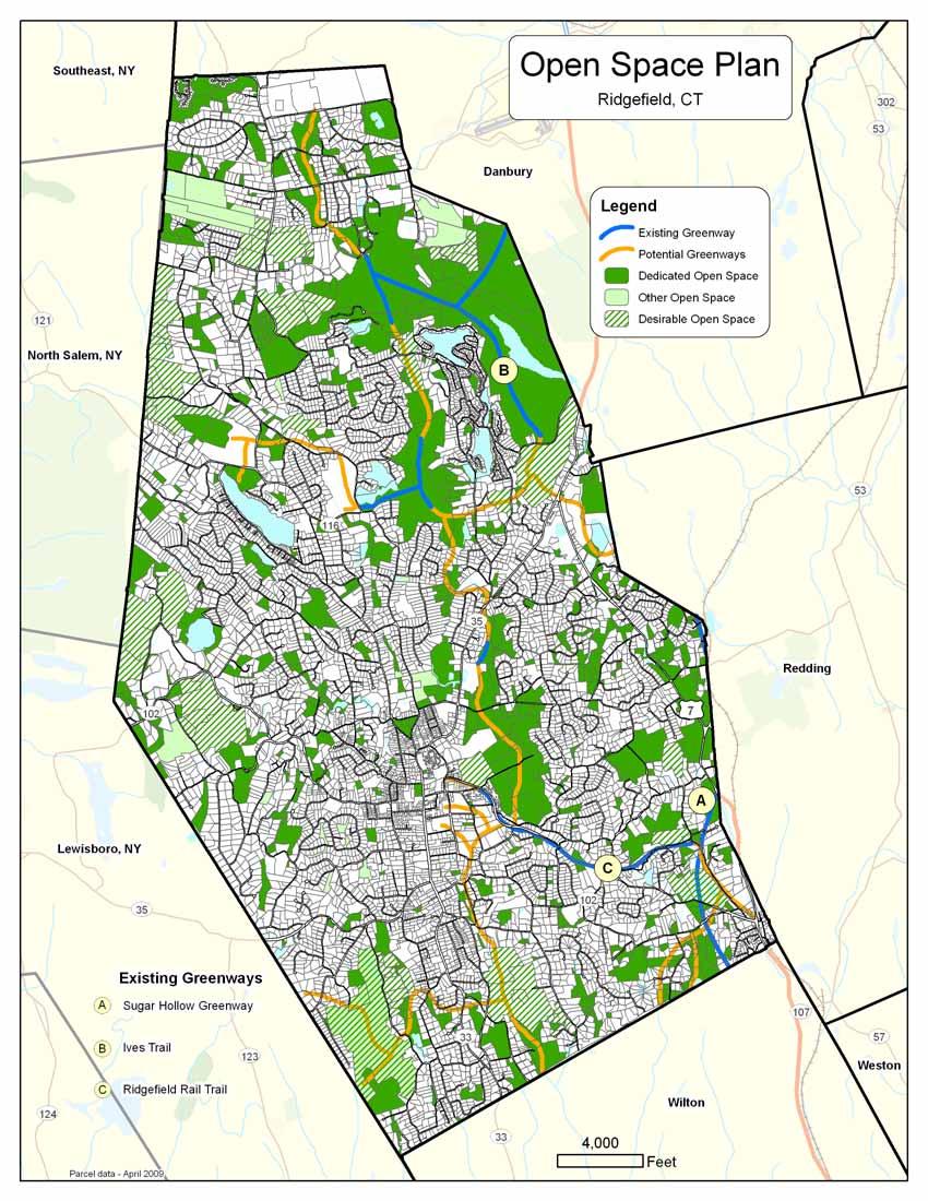
1 CHAPTER 7: OPEN SPACE OVERVIEW Ridgefield has made tremendous progress permanently preserving areas of town as open space. Open space preservation can serve many important purposes, including: protect the health of the environment, preserve habitats for biological diversity, conserve important natural and historic resources, preserve lands for parks and recreational uses, protect community character, provide fiscal and economic benefits, and shape development patterns. Natural resource protection emerges as perhaps the most important aspect of open space protection as more of Ridgefield s land becomes developed. This Chapter provides an overview of open space in Ridgefield and strategies for the continued protection of open space. Preserve open space to protect natural resources, enhance character and provide passive recreation opportunities 2010 Ridgefield Plan of Conservation and Development 7-1
2 Open Space Calculations The open space calculations are based on the best information available at this time: a combination of data from the assessor, the Town s geographic information system (GIS), and the knowledge of local officials. These calculations are likely an underestimate of the total protected open space in Ridgefield because not all parcels have been categorized as open space in existing databases. Also, because the Town s GIS and assessor s databases are not integrated, not all open space could be mapped, but its acreage is included in calculations. Acreage calculations are as follows: Protected Open Space 4,994 acres (22% of Ridgefield) Other Open Space 763 acres (4%) Total Open Space 5,757 acres (26%) OPEN SPACE IN RIDGEFIELD Open space is vacant land set aside for conservation or passive recreation purposes, whether publicly or privately owned. Passive recreation includes trails for hiking and/or non-motorized access (bike paths, horse trails, etc.). For this Plan, open space is categorized as follows: Protected (or Dedicated) Open Space is land that shall remain as open space; it may include passive recreation. This includes: o Town-owned conservation land deeded to be under the jurisdiction of the Conservation Commission o State and Federal parkland o Parcels owned by the Land Conservancy o Some homeowner association lands (only where the database indicates it is permanently protected) o Some multi-use parcels (if a large portion of the parcel is open space; e.g., the Recreation Center parcel, some school properties) o Some Town parks (if predominantly used for passive recreation) Other open space is land that currently provides open space but might not be permanently protected from development. This includes: o Remainder of homeowner association land (much of this land might be permanently protected, but some have active recreation facilities or might in the future) o Golf courses o Water company lands Calculations indicate that 26% of Ridgefield is classified as open space under the above categories. Work should continue to update and integrate the assessor s database and the Town s GIS to accurately identify parcels protected as open space. As those systems improve, the percentage of open space can be more accurately calculated. In addition to deeded open space, there are many parcels partially protected with Conservation Easements. These are difficult to quantify because they do not appear separately in Town databases. The Land Conservancy owns easements covering 140 acres and the Town owns a Conservation Easement for Brewster Farm, covering 100 acres, in addition to many smaller easements on individual properties. Most people tend to perceive open space as any land that is not built upon. However, vacant land that is in private ownership may be developed in the future all of the land in Ridgefield that is perceived as open space is not, in fact, preserved as open space Ridgefield Plan of Conservation and Development
3 OPEN SPACE PRIORITIES Continue to Preserve Open Space The Town has made tremendous efforts preserving open space and those efforts should continue. The objective of this Plan is to preserve at least 30 percent of the total acreage of the Town as permanently protected open space. This would mean that another 1,800 acres should be preserved as open space. With only 3,100 acres of vacant land remaining, this objective may be difficult to achieve. Because of this challenge, permanently preserving land in the other open space category as protected open space may be critical. Future open space preservation efforts should be targeted towards protecting and acquiring important resources and maximizing open space benefits to the community. In particular, efforts should continue toward creating a meaningful open space system that provides for contiguous open space, protects important natural resources, and protects character. To focus on preserving meaningful open space, it is important that the fee-in-lieu of open space provision in the subdivision regulations continues. This can help avoid the creation of random pockets of open space that exist simply because a given parcel was subdivided. Instead, the funds can be used for strategic acquisitions that meet open space goals. Additional funding options / opportunities should be explored such as setting aside a certain amount annually in the Town s budget and seeking grants. Subdivision regulations should be amended to provide guidelines for desirable open space, consistent with guidelines in the zoning regulations for PRD subdivisions. The use of conservation easements, both donated and acquired, is an important tool in open space preservation and should be encouraged. Preserve Greenways Greenways can enhance the value of existing open space areas through interconnections. They can also provide wildlife habitat, provide recreational use, preserve community character, and contribute to an enhanced quality of life. Greenways can connect open spaces and destinations (such as parks, schools, and other areas). The Ives Trail is an example of a successful regional greenway. Opportunities to create additional greenways, such as along old logging roads, driftways, and other rustic byways, should be pursued. Previous POCDs have supported the Sugar Hollow Greenway as a linear series of interconnected open space parcels between Ridgefield and Norwalk, roughly coinciding with the nowabandoned Super 7 expressway corridor. In 2009, representatives of the towns of Ridgefield, Redding, Wilton, Weston and Norwalk started working together to develop the Norwalk River Valley Trail within the Sugar Hollow Greenway. The trail would connect Long Island Sound in Norwalk to southern Danbury with connections to local trail systems. Funding and the level of support from the public will dictate the nature of the trail and the feasibility for multimodal transportation (for bikeways and pedestrians) Ridgefield Plan of Conservation and Development 7-3
4 Current PA-490 Policy Excerpts from Section 12-8 of the Ridgefield Subdivision Regulations:... the following land is designated open space land for purposes of taxation under said statutes: 1. All unimproved contiguous parcels of land, excluding house lots, held in single-unit ownership which consists of at least the minimum lot size required for the zoning district within which the premises are located as designated on the latest official zoning map. 2. All validated wetlands, excluding house lots,... The following are excluded from open space land classification: 1. Any land containing improvements such as but not limited to swimming pools, tennis courts, buildings, and septic systems, 2. Any land legally subdivided into residential lots, and 3. Any land zoned for nonresidential uses with the exception of validated wetlands. The section of the Norwalk River Valley Trail in Ridgefield will enhance Ridgefield s greenway system and contribute many benefits, including: protection of several high quality stratified drift aquifers and wetland systems that supply both the Saugatuck River (public water supply watershed) and the Norwalk River, protection of ecologically significant habitats, rare species, and biodiversity, protection of historic sites such as foundation ruins, stone walls, and old roads, interconnection of open spaces (including Wooster Mountain State Park, the Weir Farm National Historic Site and the Wilton Town Forest), and protection of scenic resources such as ridges, rivers, ponds, forests, marshes, bogs, vernal pools, and waterfalls. Recent State legislation might facilitate the sale of the expressway right-of-way lands to municipalities. Should this occur, Ridgefield should pursue purchasing these parcels. This greenway and other possible future greenways are illustrated on the Open Space Plan. Preserve Perceived Open Space and Unprotected Open Space The Public Act 490 program allows local assessors to reduce the assessment on land that is categorized as farm, forest, or open space. The reduced assessment diminishes the tax burden on the parcel and reduces what can be an incentive to development. This program helps to defer development and maintain the amount of perceived open space in Ridgefield. While State Statutes (CGS ) provide criteria for designation as farm or forest land, the POCD is an important step in the designation of open space land. This Plan recommends that the existing open space assessment policy be continued (see sidebar). Approximately 62 acres of perceived open space in Ridgefield is owned by public water providers for watershed protection purposes. It is reasonable to assume that much of this land will remain undeveloped over the long term in order to protect these water supplies. However, water companies can decommission certain types of surplus land and sell it; this has occurred in a number of communities in the State. State legislation gives municipalities the right of first refusal in such instances. Ridgefield should maintain contact with water companies to be aware of watershed lands that become available. The Town should also track DEP and ConnDOT lands that may be released for purchase Ridgefield Plan of Conservation and Development
5
6 Promote the Enjoyment of Open Space for All Use of the Town s open space by residents is important, not only for the health benefits of recreational activities, but because use can increase the appreciation of the Town s natural environment. Such appreciation can help build support for additional open space preservation. The Town should continue to provide information on parcels and trails and sponsor events on town open spaces. Where feasible, Ridgefield should increase the accessibility of its open space for all ages and physical abilities. Promote Stewardship of Open Space The Conservation Commission and the Land Conservancy are the primary stewards of open space properties in Ridgefield. Donors of open space lands often request that the properties be preserved for a specific purpose. Volunteers in each of the organizations work to manage and maintain the open spaces in order to preserve the environmental, aesthetic and recreational functions of the land, for the enjoyment all residents. The Town should continue to support its open space preservation stewards, to protect and maintain the intended functions of the lands, and to respect the donors intentions. Adjoining landowners should be encouraged to manage their properties in ways that complement the open space they adjoin Ridgefield Plan of Conservation and Development
7 OPEN SPACE PRESERVATION STRATEGIES Continue to Preserve Open Space 1. Continue open space preservation and acquisition efforts. 2. Preserve 30 percent of Ridgefield as protected open space. 3. Continue allowing a fee-in-lieu of open space to provide funding for protection of meaningful open spaces. 4. Explore additional funding opportunities. Preserve Greenways 5. Tie existing and new open space and recreational areas together into an integrated greenway system. 6. Preserve the Sugar Hollow Greenway and promote the Norwalk River Valley Trail. 7. Establish a series of trails as a key element in connecting open space and recreation areas into an integrated system. 8. Preserve old railways, trolley lines, logging roads, driftways, and other rustic byways as open space trails, where appropriate. Preserve Perceived Open Space 9. Maintain the PA-490 policy as an incentive for preservation of open space. 10. Stay apprised of potential surplus land disposition by water companies and the State of Connecticut. Promote the Enjoyment of Open Space 11. Continue to provide information on open space passive recreation opportunities. 12. Where feasible, improve accessibility for all ages and physical abilities Ridgefield Plan of Conservation and Development 7-7
8 Intentionally blank Ridgefield Plan of Conservation and Development
RECREATION, OPEN SPACE AND GREENWAYS ELEMENT GOALS, OBJECTIVES, AND POLICIES
 RECREATION, OPEN SPACE AND GREENWAYS ELEMENT GOALS, OBJECTIVES, AND POLICIES GOAL R-1: DEVELOP A RECREATION, OPEN SPACE AND GREENWAYS SYSTEM AS AN INTEGRAL COMPONENT OF AN OVERALL, COUNTY-WIDE ECONOMIC
The following principles guide the development of goals and strategies to protect and promote these amenities:
 OPEN SPACE/PARKS/TRAILS/RECREATION GOALS/STRATEGIES Cherry Hills Village is a living environment that offers low density development, open areas, public scenic vistas, public trails and public parks. This
3. VISION AND GOALS. Vision Statement. Goals, Objectives and Policies
 Vision Statement Queen Creek s interconnected network of parks, trails, open spaces and recreation opportunities provide safe and diverse activities and programs that sustain its unique, small town, equestrian
RECREATION AND OPEN SPACE ELEMENT GOALS, OBJECTIVES, AND POLICIES
 RECREATION AND OPEN SPACE ELEMENT GOALS, OBJECTIVES, AND POLICIES Goal 7 To provide park facilities, recreation programs, and open space resources that are safe, adequate, and accessible to all City residents,
Open Space and Farmland Preservation
 Vibrant. Green. Connected. Competitive. Open Space and Farmland Preservation Statement of Purpose The purpose of this section of the Plan is to encourage and support the preservation of open space areas
Executive Summary Purpose of the Plan Defining Open Space and Greenways
 Executive Summary Bucks County possesses a vast array of open space resources including natural areas, parks, farmland and historic and cultural resources that contribute to a high quality of life valued
Exhibit A. 8:9 Scuffletown Rural Conservation District
 Exhibit A 8:9 Scuffletown Rural Conservation District 8:9.1 Intent and Purpose The Scuffletown Rural Conservation (SRC) District is intended to provide for residential development that supports the development
OPEN SPACE AND RECREATION
 OPEN SPACE AND RECREATION The Town celebrates and maintains the spectacular visual character of our Sonoran Desert setting and we value our open space, mountain views, washes, vegetation, and wildlife.
Parks, Trails, and Open Space Element
 P arks, Recreation, and Open Space are important components of the quality of life desired by the residents of Elk Grove. This Element of the General Plan addresses the City s goals, policies, and actions
Chapter 5: Recreation
 Chapter 5: Recreation Introduction and Setting Recreational opportunities within Nevada County are varied, ranging from public parks with intensively used active recreational facilities, to vast tracts
Parks, Trails, and Open space Element
 Parks, Trails, and Open space Element Parks, Trails, and Open Space element Parks, Recreation, and Open Space are important components of the quality of life desired by the residents of Elk Grove. This
CONCLUSION AND IMPLEMENTATION
 Lisbon s Vision CONCLUSION AND IMPLEMENTATION 7 Lisbon residents clearly appreciate the character, amenities, and opportunities that define our community. This Plan of Conservation and Development identifies
The City shall enhance and improve the accessibility of parks and recreational facilities while protecting their quality. by:
 GOALS, OBJECTIVES AND POLICIES GOAL 1: To provide open space and recreation as an essential element needed for the betterment of the City s character and quality of urban life. The City shall plan for
STEWARDSHIP OF LONG ISLAND SOUND S ECOLOGICAL AND RECREATIONAL RESOURCES
 STEWARDSHIP OF LONG ISLAND SOUND S ECOLOGICAL AND RECREATIONAL RESOURCES Robin Kriesberg, Save the Sound, Inc. Thomas Halavik, US Fish and Wildlife Service Coastal Program An Initiative to Identify, Protect
RECREATION AND OPEN SPACE ELEMENT
 RECREATION AND OPEN SPACE ELEMENT Last amended August 19, 2008 Table of Contents Objective Page 5.1 Park system defined... 5-1 5.2 Access to parks and recreational facilities... 5-2 5.3 Recreation and
Yadkin River Greenway Feasibility Study Fact Sheet Village of Clemmons, Town of Lewisville, Town of Bermuda Run
 Fact Sheet Village of Clemmons, Town of Lewisville, Town of Bermuda Run Project Background The Yadkin River Greenway Feasibility Study is a joint project with the Village of Clemmons, the Town of Bermuda
1. Parks & Recreation Neighborhood Parks Community Parks Special Use Sites 2. Open Space 3. Trails
 Appendix A: Park Classifications The intent of parks and recreation classifications is to aid in making acquisition and design decisions for park sites, facilities and the organization of recreation space
Chapter 5 Greenway Corridors
 Chapter 5 Greenway Corridors Corridor Identification and Prioritization The inventory and analysis phase identified and mapped resources that contribute to greenway development. Corridors were then designated
TOWN OF SPRINGFIELD, NEW HAMPSHIRE
 TOWN OF SPRINGFIELD, NEW HAMPSHIRE NATURAL RESOURCES INVENTORY EXECUTIVE SUMMARY March 2008 Prepared by: Watershed to Wildlife, Inc. Natural Resource Consultants 42 Mill Street, Suite 3 Littleton, NH 03561
G. RECREATION AND OPEN SPACE ELEMENT. The following summarizes the Recreation and Open Space Element:
 G. RECREATION AND OPEN SPACE ELEMENT The purpose of the Element is to provide the framework and direction for a comprehensive system of public and private sites for recreation, including, but not limited
Provide and maintain sufficient public parks, recreation facilities, and open space to meet the recreational needs of County residents and visitors.
 (ROS) Goal Provide and maintain sufficient public parks, recreation facilities, and open space to meet the recreational needs of County residents and visitors. OBJECTIVE ROS.01 The County shall acquire,
FUTURE LAND USE PLAN 7
 FUTURE LAND USE PLAN 7 The recommendations of each of the preceding chapters can be combined to present an overall Future Land Use Plan for Wilton. The Future Land Use Plan, presented on the following
Draft Stillwater 2030 Comprehensive Plan- Goals and Policies
 Draft Stillwater 2030 Comprehensive Plan- Goals and Policies Instructions- Review each goal and policy and discuss with group any changes, deletions for additions to the list using your groups pen. Keep
Whitemarsh Township Greenway Plan
 Whitemarsh Township Greenway Plan Prepared for: Whitemarsh Township August 16, 2007 Table of Contents Table of Contents... i Introduction... 1 Study Area Setting... 2 Regional Setting... 2 Township Character...
This page intentionally blank.
 This page intentionally blank. Parks, Recreation, and Open Space Chapter Relationship to Vision Vision Parks, Recreation and Open Space Chapter Concepts County Government. County government that is accountable
EL DORADO COUNTY GENERAL PLAN PARKS AND RECREATION ELEMENT PRINCIPLE INTRODUCTION STATE AUTHORIZATION
 EL DORADO COUNTY GENERAL PLAN PARKS AND RECREATION ELEMENT PRINCIPLE The General Plan must identify the types of governmental services, including parks and recreation facilities, which are necessary to
City of Surrey Ecosystem Management Study. Integration of ecological processes with land use
 City of Surrey Ecosystem Management Study Integration of ecological processes with land use Natural areas in Surrey are changing as the City grows and evolves. Many important natural areas remain or may
Central Lake Ontario Conservation Conservation Lands Master Plan
 Conservation Lands Master Plan Top 13 Frequently Asked Questions 1. What are conservation lands? Where are these conservation lands located in the Central Lake Ontario Conservation watershed? Conservation
Parks, Open Space and Trails
 Introduction Parks have often been referred as the lungs of our cities, cleansing the air of pollutants and particulate matter. Parks are also gathering places for families and community. They offer spaces
PARKS AND RECREATION
 PARKS AND RECREATION WHAT YOU WILL FIND IN THIS CHAPTER: Background information on the development of the Park, Recreation, and System Plan (PRSP). General overview of Ellensburg s parks and recreation
Countywide Green Infrastructure
 Montgomery County s Countywide Green Infrastructure F U N C T I O N A L M A S T E R P L A N The Maryland National Capital Park and Planning Commission INFRASTRUCTURE An underlying base or foundation especially
Support the implementation of Cape Coral's Comprehensive Plan. Protect and utilize the unique natural resources in the City.
 7.0 OVERVIEW - RECOMMENDATIONS Chapter 7 The preparation of the Cape Coral Parks and Recreation Master Plan spanned a period of approximately 12 months. Plan preparation included the input of a wide range
Approved 8/18/94 Revised 3/21/02 Revised 5/14/09
 Approved 8/18/94 Revised 3/21/02 Revised 5/14/09 Guidelines for Calculation and Provision of Open Space in Developments of Regional Impact Technical Bulletin 94-001, as Amended Contents Introduction...2
Regional Context Statement
 Regional Context Statement REGIONAL CONTEXT STATEMENT 3. REGIONAL CONTEXT STATEMENT In 1995, the Provincial Government passed into law the Growth Strategies Act. The purpose of this provincial initiative
Riparian Buffer on the Bushkill Creek. Policies
 Riparian Buffer on the Bushkill Creek Riparian buffers provide numerous benefits to landowners and the community by protecting groundwater recharge areas, providing flood control, providing stormwater
The transportation system in a community is an
 7 TRANSPORTATION The transportation system in a community is an important factor contributing to the quality of life of the residents. Without a sound transportation system to bring both goods and patrons
TOWN OF BETHLEHEM OPEN SPACE CONSERVATION PLAN PUBLIC MEETING: OCTOBER 12, 2017
 TOWN OF BETHLEHEM OPEN SPACE CONSERVATION PLAN PUBLIC MEETING: OCTOBER 12, 2017 Welcome and Agenda 6:00 6:45: Open House, Part One 6:45 7:15: Presentation and Questions 7:15 8:00: Open House, Part Two
RECREATION AND OPEN SPACE VISION
 City of South Lake Tahoe General Plan Policy Document Recreation and Open Space Element INTRODUCTION This element provides the policy context for the City of South Lake Tahoe to achieve its vision for
Chapter 6. Overall Vision RECOMMENDATIONS. More Trail and Trail. Connections. Equal Access to Park. Facilities and Programs. Water Access.
 Overall Vision More Trail and Trail Connections Equal Access to Park Facilities and Programs Water Access Environment Variety Chapter 6 RECOMMENDATIONS Chapter 6 The following recommendations for park,
Mendota Heights 2040 Comprehensive Plan Draft Vers
 4 Parks and Trails The City of Mendota Heights boasts a variety of recreational and open space opportunities. Few cities can claim access to regional trails, riverside and lakeside parks, scenic bluffs
Recreation, Open Space, Greenway Plan & Smart Agriculture Initiative
 Recreation, Open Space, Greenway Plan & Smart Agriculture Initiative This portion of the Plan represents a follow-up to Section 2, which addressed the natural environment of the two townships. This portion
ARTICLE IV: DEVELOPMENT STANDARDS 404 MASTER PLANNING
 IV 13 404 MASTER PLANNING Master Planning through the Site Analysis (Master Planning Site Analysis) or Planned Development (Master Planning Planned Development) is provided to encourage development which
SECTION FOUR: MISSION STATEMENT, GOALS & OBJECTIVES
 SECTION FOUR: MISSION STATEMENT, GOALS & OBJECTIVES Chapter Summary Chapter Ten: Mission Statement, Goals & Objectives To fulfill its mission, the Parks and Recreation Commission has identified four basic
Community Conservation Workshop. Lake Placid
 Community Conservation Workshop Lake Placid 2 Community Conservation Program Welcome! We have designed a Community Conservation Program that listens to the needs of community members. We are conducting
CONSERVATION STRATEGIES WORKBOOK
 Booklet #4 January 2, 2017 4 CONSERVATION STRATEGIES WORKBOOK Overview This booklet has been prepared for the Willington Planning and Zoning Commission to use as part of the formulation of the 2018 Plan
2010 Plan of Conservation and Development
 2010 Plan of Conservation and Development Wilton Planning and Zoning Commission Adopted November 2, 2009 Effective January 1, 2010 WILTON 2010 PLAN OF CONSERVATION & DEVELOPMENT PARTICIPANTS Planning &
Florida Greenways and Trails System (FGTS) Plan Goals, Strategies and Objectives
 Plan Goals, Strategies and Objectives") Identification and Prioritization of the FGTS The Florida Greenways and Trails System (FGTS) is made up of existing, planned and conceptual trails and ecological greenways that form a connected, integrated
Identification and Prioritization of the FGTS The Florida Greenways and Trails System (FGTS) is made up of existing, planned and conceptual trails and ecological greenways that form a connected, integrated
STAFF RECOMMENDATION: Adopt the Parks and Recreation Master Plan 2013, or take other action as deemed appropriate.
 Regular 7. CITY COUNCIL AGENDA Meeting Date: 12/02/2013 TITLE: Parks and Recreation Master Plan 2013 Adoption Proposal - Dwight Curtis Responsible Staff: Dwight Curtis Backup Material: Backup material
CHAPTER 22 Rural Open Space Community Developments
 CHAPTER 22 Rural Open Space Community Developments Section 22.1 Description and Purpose The intent of this Chapter is to offer property owners an alternative to traditional zoning requirements for rural
OPEN SPACE, PARKS, AND HISTORIC SITES
 OPEN SPACE, PARKS, AND HISTORIC SITES The conservation of land, water, and historic resources, and the related provision of recreation opportunities, is one of the most important factors in maintaining
{Best Practices. Summary of Tools, Strategies and Best Practices from 11 Michigan Case Study Communities
 Case Studies Michigan Coastal Community Working Waterfronts { Summary of Tools, Strategies and from 11 Michigan Case Study Communities Table of Contents Zoning...2 Community and Stakeholder Collaboration
Master Plan Objectives and Policies
 Master Plan Objectives and Policies Introduction This chapter identifies the Park issues and recommended policies established by this Master Plan. The issues were identified through meetings with staff,
Bergen County Parks Master Plan
 Bergen County Parks Master Plan Submission for NJASLA Professional Award Currently: Over 9,000 acres, 36 parks,1 nationally accredited zoo, 5 golf courses, 2 equestrian centers, 1 Environmental center,
Rural Land Use Designations Kittitas County December 6, 2007 Draft
 KITTITAS COUNTY COMMUNITY DEVELOPMENT SERVICES 411 N. Ruby St., Suite 2, Ellensburg, WA 98926 CDS@CO.KITTITAS.WA.US Office (509) 962-7506 Fax (509) 962-7682 Rural Land Use Designations Kittitas County
DRAFT Open Space Technical Bulletin
 DRAFT Open Space Technical Bulletin This guidance is intended to clarify how the Open Space Goal and Objectives of the Regional Policy Plan (RPP) are to be applied and interpreted in Cape Cod Commission
Town of Rico Three Mile Plan for Annexation
 Town of Rico Three Mile Plan for Annexation 10.20.2010 Adopted by Resolution 2010-2 Produced with funding support from the Colorado Department of Local Affairs 2 Content Guide Introduction. 3 Annexation
E. RURAL COMMERCIAL/INDUSTRIAL PARK MODEL
 E. RURAL COMMERCIAL/INDUSTRIAL PARK MODEL 1. PURPOSE The purpose of the Rural Commerce/Industrial Park Model is to provide parameters within which a grouping of business buildings with parking, loading
Objectives and Strategies for the Integration of Recreation, Parks and Open Space in Regional Plans
 BULLETIN 2 Objectives and Strategies for the Integration of Recreation, Parks and Open Space in Regional Plans TABLE OF CONTENTS Introduction 3 Land-use Framework Outcomes 1 4-8 Land-use Framework Outcomes
CHAPTER 4 FUTURE LAND USE AND URBAN SERVICES DISTRICTS
 CHAPTER 4 FUTURE LAND USE AND URBAN SERVICES DISTRICTS Introduction This chapter discusses how Benzie County should grow and change in the future. A community can grow and change in many different ways.
Planning for and Managing Open Space and Natural Areas
 Planning for and Managing Open Space and Natural Areas Increasingly, development proposals in Delaware include large amounts of open space and natural areas. While open space is important as a community
Community Conservation Workshop. Saranac River Basin Communities
 Community Conservation Workshop Saranac River Basin Communities 2 Community Conservation Program Welcome! We have designed a Community Conservation Program that listens to the needs of community members.
Park Board Strategic Framework. (Mission, Vision, Directions, Goals and Objectives) June 27, 2012
 June 27, 2012") Park Board Strategic Framework (Mission, Vision, Directions, Goals and Objectives) June 27, 2012 Planning Process Overview Phase 1: Renewed Strategic Framework Phase 2: Objectives Phase 3: Prioritization
Park Board Strategic Framework (Mission, Vision, Directions, Goals and Objectives) June 27, 2012 Planning Process Overview Phase 1: Renewed Strategic Framework Phase 2: Objectives Phase 3: Prioritization
10.0 Open Space and Public Realm
 10.0 Open Space and Public Realm 10.0 Open Space and Public Realm The Public Open Space System is comprised of: outdoor spaces available for public use that are either publicly owned (e.g., parks and
ESTABLISH AN EFFICIENT TOWN CENTER
 ESTABLISH AN EFFICIENT TOWN CENTER 4 Overview Lisbon residents are proud of the history of Newent and at the same time recognize its current importance as a centralized location for a variety of municipal
City of Surrey Ecosystem Management Study. Integration of ecological processes with land use
 City of Surrey Ecosystem Management Study Integration of ecological processes with land use Natural areas in Surrey are changing as the City grows and evolves. Many important natural areas remain or may
Minnesota Department of Natural Resource - Natural Resource Guidance Checklist Conserving Natural Resources through Density Bonuses
 Minnesota Department of Natural Resource - Natural Resource Guidance Checklist Conserving Natural Resources through Density Bonuses NRDB Why Use Density Bonuses & This Checklist Local units of government
Vision Statement for the Town of Flower Mound Master Plan The Town of Flower Mound Master Plan furthers the established community based vision to:
 Vision Statement for the The furthers the established community based vision to: Preserve the country atmosphere and natural environment that makes Flower Mound a unique and desirable community; Mitigate
Parks and Open Space Preservation and Dedication. January 26, 2016 Fort Worth City Council Pre-Council Meeting Randle Harwood and Richard Zavala
 Parks and Open Space Preservation and Dedication January 26, 2016 Fort Worth City Council Pre-Council Meeting Randle Harwood and Richard Zavala Purpose How does the City of Fort Worth preserve and protect
OPEN SPACE FORUM SEPTEMBER 28, 2016 THE ARTS CENTER
 OPEN SPACE FORUM SEPTEMBER 28, 2016 THE ARTS CENTER AGENDA: 1. Introductions 2. History of Open Space Committee 3. Saratoga Springs Open Space Purchases 4. Committee Actions and Path Forward 5. Comments
Preface. Erie. Scranton. Allentown. Pittsburgh. Harrisburg. Philadelphia
 The Southern Alleghenies Region The Southern Alleghenies Region spans the Laurel Highlands and Allegheny Front in the west across the Appalachians to the east. It is comprised of Blair, Bedford, Cambria,
Major Subdivision Sketch Plan Checklist
 This checklist provides specific requirements that are apart of the Sketch process. The entire process is described by the Huntersville Subdivision Review Process which details all the submittal and resubmittal
Town of Peru Comprehensive Plan Executive Summary
 Town of Peru Comprehensive Plan Executive Communities that plan grow by choice, not by chance. A plan makes growth thoughtful, understandable, and predictable. A plan shows that a community is managing
City of Chickasaw Land Use Comprehensive Plan 2030 Chapter5-Draft(2)Public review_
Public review_") Land Use Land Use refers to the activity or development characteristics of a given parcel of land. The Land Use Plan presented in the following pages, represents the City of Chickasaw s official position
Land Use Land Use refers to the activity or development characteristics of a given parcel of land. The Land Use Plan presented in the following pages, represents the City of Chickasaw s official position
Section 3 INVENTORY OF RECREATION LAND AND FACILITIES
 Photo of Juan Bautista de Anza Park Section 3 INVENTORY OF RECREATION LAND AND FACILITIES Summary of Findings Park Definitions Summary of Recreation Facilities Other Recreation Facilities Nearby Recreation
SECTION 1 Introduction...1. SECTION 2 Regional Context Criteria for Planning Districts Description of Planning District...
 Table of Contents SECTION 1 Introduction...1 SECTION 2 Regional Context...2 2.1 - Criteria for Planning Districts...2 2.2 - Description of Planning District...2 SECTION 3 Goals & Objectives...5 SECTION
Town of Washington Master Plan & Regulatory Audit: Interim Results
 Town of Washington Master Plan & Regulatory Audit: Interim Results May 20, 2008 Presented by: 30 Bank Street Lebanon, NH 03766 www.uvlsrpc.org Introduction & Purpose Compare the Master Plan to the regulations
Green Infrastructure. by Karen Engel, NYS DEC. NYS Department of Environmental Conservation
 Green Infrastructure by Karen Engel, NYS DEC What is Green Infrastructure? For some it s all about water Green Infrastructure techniques use soils and vegetation to infiltrate, evapotranspirate, and/or
AREASTRUCTURE PLAN AMENDMENT COCHRANE NORTH
 AREASTRUCTURE PLAN AMENDMENT COCHRANE NORTH In order to implement the vision outlined in the Conceptual Scheme, the following three amendments to the Cochrane North ASP are proposed: 1. Allow commercial
7.0 OPEN SPACE 7.1 OPEN SPACE DEDICATION CHAPTER 7: OPEN SPACE
 7.0 OPEN SPACE The intent of these requirements is to allow for the usage of centrally located unencumbered land as neighborhood open spaces and not to permit the use of leftover or otherwise unusable
DISCUSSION TOPIC: ST JOHNS RIVER & ITS TRIBUTARIES (BPII) 2030 COMPREHENSIVE PLAN POLICES AND REGULATORY FRAMEWORK
 2030 COMPREHENSIVE PLAN POLICES AND REGULATORY FRAMEWORK") DISCUSSION TOPIC: ST JOHNS RIVER & ITS TRIBUTARIES (BPII) 2030 COMPREHENSIVE PLAN POLICES AND REGULATORY FRAMEWORK St. John s River & Its Tributaries Issue Summary: The St. Johns River is an important
DISCUSSION TOPIC: ST JOHNS RIVER & ITS TRIBUTARIES (BPII) 2030 COMPREHENSIVE PLAN POLICES AND REGULATORY FRAMEWORK St. John s River & Its Tributaries Issue Summary: The St. Johns River is an important
San Diego River Coalition 2012 Work Plan
 San Diego River Coalition 2012 Work Plan Adopted November 18, 2011 The mission of the San Diego River Coalition is preserve and enhance the San Diego River, its watershed, and its natural, cultural and
6.0 Conclusions & Recommendations
 6.0 Conclusions & Recommendations 75 The research, public outreach and feasibility analysis completed for this study indicate that Trail Alternative #2 (South side of Doctors Creek) is the most comprehensive
Pittsfield Action Plan (West Branch of the Housatonic River)
") An initiative of the Massachusetts Executive Office of Energy and Environmental Affairs in partnership with the City of Pittsfield Pittsfield Action Plan (West Branch of the Housatonic River) The spring
An initiative of the Massachusetts Executive Office of Energy and Environmental Affairs in partnership with the City of Pittsfield Pittsfield Action Plan (West Branch of the Housatonic River) The spring
3-2 Environmental Systems
 3-2 Environmental Systems 3.0 ENVIRONMENTAL SYSTEMS CONTENTS 3.1 GREENWAY SYSTEM 3.1.1 General Policies 3.1.2 Natural Heritage Network 3.1.3 Natural Heritage Network Enhancement Lands 3.1.4 Rouge Watershed
Master Plan Workshop October 25, 2007 Charlotte Mecklenburg Government Center
 Master Plan Workshop October 25, 2007 Charlotte Mecklenburg Government Center Land Discussion 1. What are the most important land related issues we need to address? Protect natural areas Passive walking
GOALS, OBJECTIVES, POLICIES & PROGRAMS
 Chapter 5 GOALS, OBJECTIVES, POLICIES & PROGRAMS 5.1 Goals, Objectives, Policies & Programs This is a joint plan adopted by both the Village of Waunakee and the Town of Westport. Both communities will
APPENDIX I Presentations
 APPENDIX I Presentations Workshop Summary Report 11 Peel Region Official Plan Review May 5, 2010 Compatible Active Recreation Workshop July 29, 2010 Components of PROPR Sustainability Planning Tools/Updates
PARKS AND RECREATION ELEMENT
 PARKS AND RECREATION ELEMENT TABLE -3 First Priority 1 2 POTENTIAL SAN CARLOS TRAIL CONNECTIONS Crestview to Pulgas Ridge Open Space Preserve and San Francisco Watershed Lands Unimproved City-Owned Parcel
Northeast Quadrant Plan
 Northeast Quadrant Plan Northeast Quadrant Distinctive Features Land Use The Northeast Quadrant includes all the area within the planning area that is east of Interstate 5 and to the north of State Route
process of the Land Development Code to assure regional parks are available County-wide.
 GOAL 9.0. It is the goal of the Broward County Board of County Commissioners to provide safe and adequate recreation sites and facilities, including cultural art facilities, and open space to satisfy the
A Growing Community Rural Settlement Areas
 Town of Huntsville Official Plan Review - POLICY BACKGROUND PAPER A Growing Community Rural Settlement Areas BACKGROUND: In addition to the fully municipally-serviced Urban Settlement Area and the Hidden
PARKS AND RECREATION, GREENWAYS, BLUEWAYS, and GREEN SYSTEMS PARKS AND RECREATION, GREENWAYS, BLUEWAYS, GREEN SYSTEMS
 PARKS AND RECREATION, GREENWAYS, BLUEWAYS, and GREEN SYSTEMS Source: Albemarle County Parks and Recreation 2013 PARKS AND RECREATION, GREENWAYS, BLUEWAYS, GREEN SYSTEMS GOAL: Albemarle will have a system
Southeast Quadrant Plan
 Southeast Quadrant Plan Southeast Quadrant Distinctive Features Land Use The Southeast Quadrant includes all the area within the planning area that is east of Interstate 5 and south of State Route 44.
LAND USE MEADOWS PLANNING AREA
 LAND USE MEADOWS PLANNING AREA I. Profile of Meadows Planning Area A. Location Meadows Planning Area is delineated by I-5 on the north, the Nisqually Bluffs representing the growth boundary on the east,
Wilton Center and Villages Survey
 1 Agenda 2 Wilton Center and Villages Survey 3 Business Owners What is the best thing about owning/running a business in Wilton? Location (17 responses) Commute (13 responses) Community and quality of
Sorted citizen input comments in review of Blount County plans July, August, and September 2007
 Sorted citizen input comments in review of Blount County plans July, August, and September 2007 The following presents sorted citizen input comments from three sessions held in July, August and September
Little Neck Planning Area
 Little Neck Planning Area Current Reality The Little Neck Planning Area is characterized by established residential neighborhoods, Town Center and Pembroke. The Eastern and Western Branches of the Lynnhaven
Comprehensive Plan ADOPTED APRIL 2014
 Comprehensive Plan ADOPTED APRIL 2014 8 8. Outstanding Recreational & Cultural Opportunities We are proud of our community s parks and recreation system. Our community will ensure that the legacy of our
The West Vaughan Employment Area Secondary Plan Policies
 Part 2: The West Vaughan Employment Area Secondary Plan Policies 2.1 General Policies It is the policy of Council: 2.1.1. That the West Vaughan Employment Area (the WVEA), identified on Schedule 1, will
ELIGIBILITY CRITERIA CHECKLIST OPEN SPACE CLASSIFICATION
 THURSTON COUNTY DEVELOPMENT SERVICES OPEN SPACE TAX PROGRAM ELIGIBILITY CRITERIA CHECKLIST OPEN SPACE CLASSIFICATION Use this checklist to help you determine whether your property is eligible for open