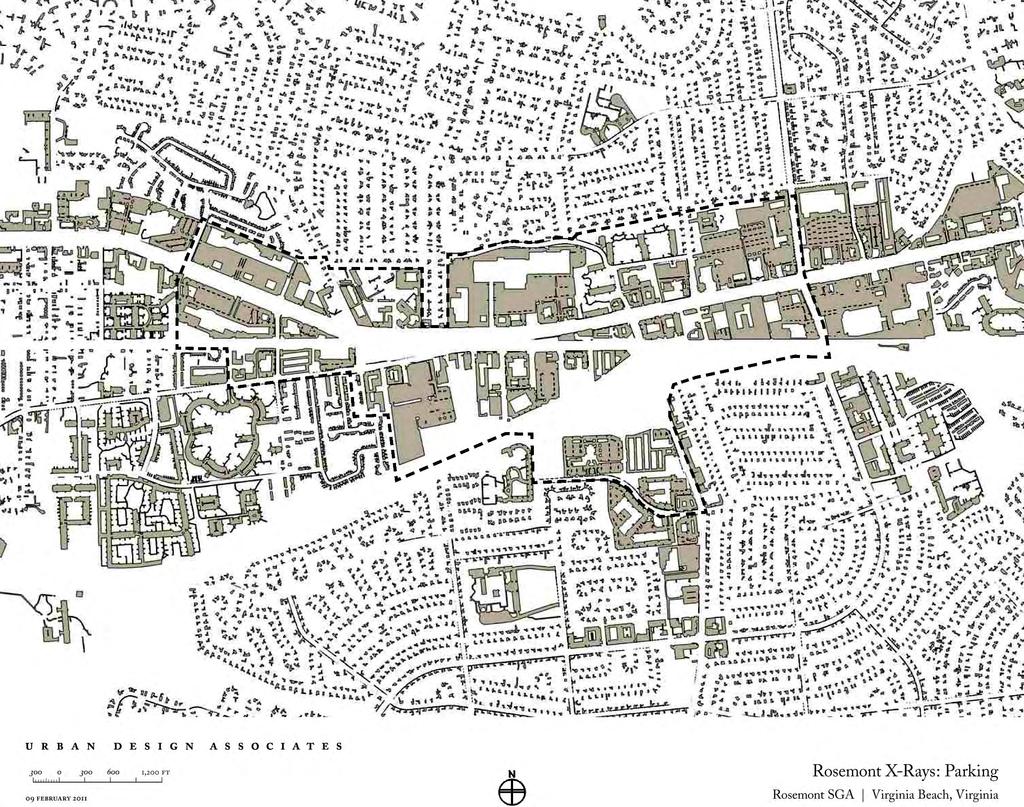
Rosemont SGA virginia beach, va
|
|
|
- Phebe Reynolds
- 6 years ago
- Views:
Transcription
1 Rosemont SGA virginia beach, va phase 3 PUBLIC Presentation Prepared for the City of Virginia Beach 14 June, 2011 urban design associates miles agency, rclco, urs, vhb & wpl

2 Slide Title
3 A Three Phase Process 1. Understanding: Figuring out what is going on. 2. Exploring: Trying out some ideas. 3. Deciding: Choosing what to do. (All with broad based participation)
4 A Three Phase Process: Where are we today? 1. Understanding: Figuring out what is going on. 2. Exploring: Trying out some ideas. 3. Deciding: Choosing what to do. (All with broad based participation)


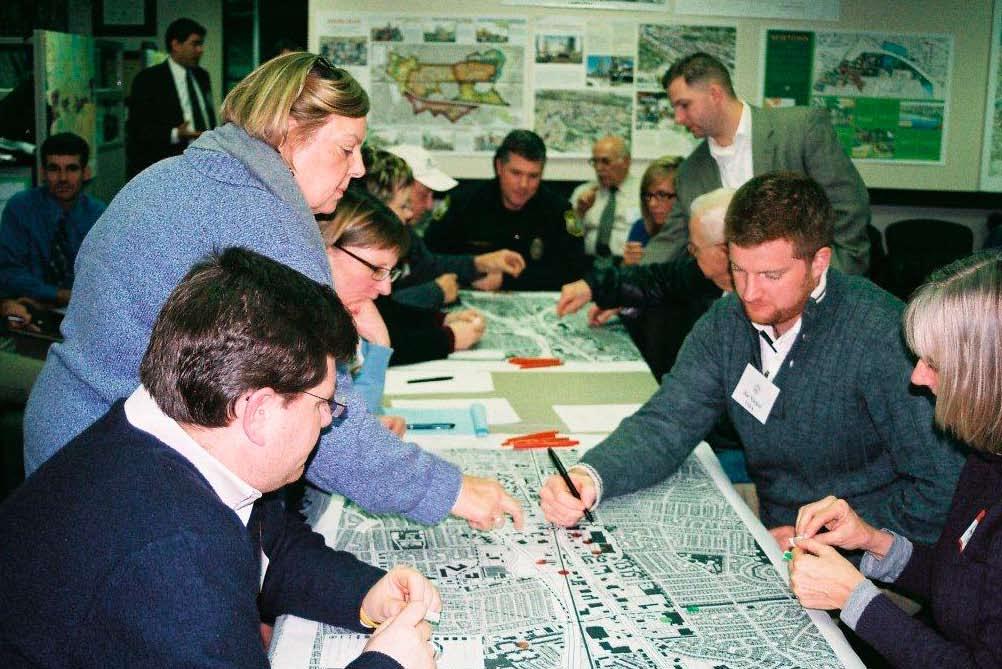
5 Summary of Phase 1: Understanding Focus group and public meeting feedback Three Questions Dot Exercise Physical analysis of the study area X-rays and Analysis Diagrams Photography and Street Sections
6 Three Questions: 1. What are the strengths? 2. What are the weaknesses? 3. What are the opportunities?
7
8 Strengths of Rosemont Nearby amenities: Mt. Trashmore and Little Neck bike path Library and civic institutions Geographically central to the city Low vacancies, investment in Loehmann s and Princess Anne Plaza, and Collins Square Strong neighborhoods: Windsor Oaks, Windsor Woods, Thalia, and Little Neck Diverse and affordable retailers including several grocers Highest bus service level in city along Virginia Beach Boulevard
9 Strengths of Rosemont (cont.) East-west routes of Virginia Beach Boulevard and Bonney Road Under-utilized land available for redevelopment Low crime Good neighboring schools Potential for Light Rail

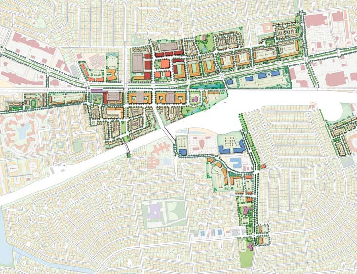
10 Thalia Road Little Neck Road Thalia Loehmanns Plaza Shopping Collins Square Shopping Lynn Shores Drive Caren Drive Casselberry Lane Birchwood Shopping Catalina Drive Malibu Virginia Beach Blvd. Bonney Road Pine Street Butternut Lane Sentara Nursing Little Angels Montessori Lynnhaven I-264 Palace Green Blvd. Windsor Woods Presidential Blvd Teakwood Drive Princess Anne Plaza Baptist Preschool South Rosemont Road Mt. Trashmore Park
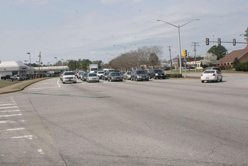
11 Weaknesses of Rosemont Lack of identity or memorable places Virginia Beach Boulevard and I-264 are barriers Dangerous and confusing intersections such as Rosemont/ Bonney/I-264 and the Little Neck/Rosemont jog Lack of pedestrian accommodation and no usable parks Car-oriented: parking lots and road travel lanes prevail Deterioration of nearby housing stock and lower-end retail properties Completely disconnected neighborhoods south of I-264
12 Weaknesses of Rosemont (cont.) Poor transitions to northern neighborhoods Lack of transit connections to the neighborhoods Lack of adequate provisions for stormwater runoff Condition of above and underground utilities
13 Thalia Road Little Neck Road Thalia Loehmanns Plaza Shopping Collins Square Shopping Lynn Shores Drive Caren Drive Casselberry Lane Birchwood Shopping Catalina Drive Malibu Virginia Beach Blvd. Bonney Road Pine Street Butternut Lane Sentara Nursing Little Angels Montessori Lynnhaven I-264 Palace Green Blvd. Windsor Woods Presidential Blvd Teakwood Drive Princess Anne Plaza Baptist Preschool South Rosemont Road Mt. Trashmore Park
14 Visions for Rosemont Connect under and over I-264 Tame Virginia Beach Boulevard Improve I-264 access Make a reason for stopping here Increase land productivity Establish a pedestrian and bicycle realm, connecting uses through trails and open space Provide access to nearby open space amenities such as Mt. Trashmore
15 Visions for Rosemont (cont.) Create functional open spaces that address recreational and stormwater management needs Create multi-modal access from the transit station to neighborhoods, Mt. Trashmore, and retail Develop mid-rise mixed-use, mixed-income, development Make arterials including and Rosemont safer and more pedestrian friendly

16 Thalia Road Little Neck Road Thalia Loehmanns Plaza Shopping Collins Square Shopping Lynn Shores Drive Caren Drive Casselberry Lane Birchwood Shopping Catalina Drive Malibu Virginia Beach Blvd. Bonney Road Pine Street Butternut Lane Sentara Nursing Little Angels Montessori Lynnhaven I-264 Palace Green Blvd. Windsor Woods Presidential Blvd Teakwood Drive Princess Anne Plaza Baptist Preschool South Rosemont Road Mt. Trashmore Park

17 Thalia Road Little Neck Road Thalia Loehmanns Plaza Shopping Collins Square Shopping Lynn Shores Drive Caren Drive Casselberry Lane Birchwood Shopping Catalina Drive Malibu Virginia Beach Blvd. Bonney Road Pine Street Butternut Lane Sentara Nursing Little Angels Montessori Lynnhaven I-264 Palace Green Blvd. Windsor Woods Presidential Blvd Teakwood Drive Princess Anne Plaza Baptist Preschool South Rosemont Road Mt. Trashmore Park
18 Analysis Summary

19 N. Lynnhaven Road Little Neck Road Thalia Road Virginia Beach Blvd Blvd Bonney Road Windsor Woods Malibu Princess Anne Plaza Baptist Preschool Little Angels Montessori Lynnhaven 264- Virginia Beach Expy Thalia Sschool Mt. Trashmore Park Loehmanns Plaza Shopping Collins Square Shopping Great American Outlet Mall Birchwood Mall Shopping Sentara Nursing SINGLE FAMILY RESIDENTIAL MULTI FAMILY RESIDENTIAL COMMERCIAL OFFICE INDUSTRIAL INSTITUTIONAL PUBLIC PARKS AND OPEN SPACE SEMI-PUBLIC OPEN SPACE COMMERCIAL AND INDUSTRIAL LAND PARKING GARAGE PARKING LOT WATER STUDY AREA EXPANDED STUDY AREA NOISE ZONES POTENTIAL TRANSIT LINE POTENTIAL STATION LOCATIONS Salina Drive South Rosemont Road Caren Drive Catalina Avenue Presidential Blvd Palace Green Blvd Trail Salina Drive Lynn Shore Drive Drive

20

21 N. Lynnhaven Road Little Neck Road Thalia Road Virginia Beach Blvd Bonney Road Salina Drive Catalina Avenue Presidential Blvd Windsor Woods Little Angels Montessori Lynnhaven South Rosemont Road Caren Drive Palace Green Blvd 264- Virginia Beach Expy Salina Drive Lynn Shore Drive Thalia Sschool Mt. Trashmore Park Sentara Nursing LAND USE LAND COVER (SQ. FT.) LAND COVER (ACRES) % OF TOTAL LAND COVER STREETS 4,268, % BUILDING FOOTPRINTS 2,482, % PARKING 6,534, % OTHER OPEN SPACE 1,960, % TOTAL 15,246,000 SQ. FT. 350 ACRES 100%
22

23 N. Lynnhaven Road Little Neck Road Thalia Road Virginia Beach Blvd Bonney Road MAJOR ARTERIAL MINOR ARTERIAL STREETS WATER STUDY AREA POTENTIAL TRANSIT LINE POTENTIAL STATION LOCATIONS Salina Drive Drive Catalina Avenue Residential Blvd Caren Drive Palace Green Blvd 264- Virginia Beach Expy Salina Drive Lynn Shore Drive

24 N. Lynnhaven Road Little Neck Road Thalia Road Virginia Beach Blvd Bonney Road ON-SITE INTERSECTIONS OFF-SITE INTERSECTIONS STUDY AREA ADDITIONAL STUDY AREA POTENTIAL TRANSIT LINE POTENTIAL STATION LOCATIONS Salina Drive South Rosemont Road Catalina Avenue Presidential Blvd Caren Drive Palace Green Blvd 264- Virginia Beach Expy Salina Drive Lynn Shore Drive

25 Market Analysis Summary
26 Regional Projections 1. Virginia Beach s regional share of the office and residential markets has begun to decline Office Projections: Residential Capture Projections : up to 3.5 million SF 17,000-30,000 new households by % of recent residential growth has been in 1 and 2 person households 5. Only 50% of 30,000 new unit demand will be for detached single-family homes; 25% will be for-sale townhouses and condominiums, and 25% will be rental apartments
27 Rosemont Positioning Rosemont is one of the few remaining places in the city, outside of Pembroke, that is ideal for capturing higher-density residential growth Rosemont can become a transit-ready residential village, providing attainable housing that attracts young, well-educated Gen-y households and Boomers looking to downsize Key properties in Rosemont can be redeveloped into mixeduse environments, with community-serving retail and amenities Large scale office development is not as desirable in Rosemont, as it would directly compete with Pembroke and Town for office demand
28 Development Program supported by Market Study Product Density/FAR Total Land Area Townhouses , Ac Mid-Rise Condominiums Mid-Rise Apartments t Acres , Acres Retail.2 20,000 41,000 50,000 52, , Acres Office Medical Office
29 Townhouses Mid-rise Condominiums Mid-rise Apartments Neighborhood Retail Office Market Potential 1,750 units 800 units 2,450 units 165,000 sq. feet 0 sq. feet Yield in Plan 756 units 650 units 1,546 units 282,000 sq. feet 213,000 sq. feet Assumes about 250 acres of redevelopment land Assumes about 136 acres of redevelopment land
30 Design Principles
31 Design Principles: Transition from strip commercial uses to mixed-use development that emphasizes townhouses and multi-family residential Create a new neighborhood center for Rosemont Improve pedestrian and trail facilities to connect neighborhoods to potential future transit and neighborhood centers Create a new street and block structure to accommodate development and improve mobility Require sustainable development practices Develop a set of design guidelines and standards for development of proper land use. streets, and open spaces


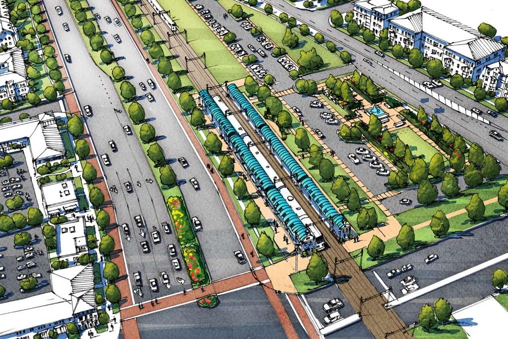
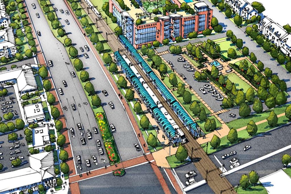
32 The Master Plan Illustrative Plan + Program Infrastructure Network Streets + Transit Open Space + Trails Stormwater Management Utilities Development Initiatives Land Use + Heights Block + Development Types Building Types Landscape + Streetscapes Key Private Development Initiatives
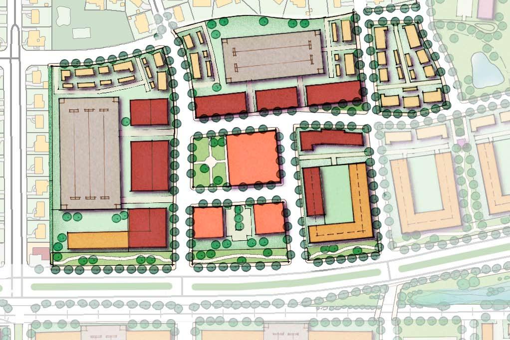
33 Thalia Road Little Neck Road Thalia Loehmanns Plaza Shopping Lynn Shores Drive Caren Drive Casselberry Lane Catalina Drive Malibu Collins Square Shopping Virginia Beach Blvd. Bonney Road I-264 Sentara Nursing Little Angels Montessori Lynnhaven Rosemont SGA Master Plan Development Program Use Area (ac.) Residential Units Built Area (s.f.) Multi-Family Residential ,776 Single-Family Residential Mixed-Use ,000 Palace Green Blvd. Windsor Woods Presidential Blvd Teakwood Drive Princess Anne Plaza Baptist Preschool South Rosemont Road Retail ,000 Office ,000 Existing (Community Amenities) 11.3 Open Space 19.1 Stormwater 17.8 Total ac. 2,952 units 495,000 s.f.
34 Infrastructure Framework Street Network Transit Open Space and Park Network Trail Network Stormwater Management + Utilities

35 Thalia Road Little Neck Road Thalia Loehmanns Plaza Shopping Lynn Shores Drive Caren Drive Casselberry Lane Catalina Drive Malibu Collins Square Shopping Virginia Beach Blvd. Bonney Road I-264 Sentara Nursing Little Angels Montessori Lynnhaven Palace Green Blvd. Windsor Woods Presidential Blvd Teakwood Drive Princess Anne Plaza Baptist Preschool South Rosemont Road local A (50' ROW) bonney road (66' row) local b (60' ROW) south plaza trail (90' row) mixed-use (70' ROW) rosemont Road (150' ROW) sentara way (50' ROW) virginia beach Boulevard (145' ROW)
 5' 12' 12' 12' 12' 12' 5' 70'")
36 Rosemont Road, Existing Section rosemont road: existing street section (north-facing) 5' 12' 12' 12' 12' 12' 5' 70' R.O.W.

37 Rosemont Road with Frontage Road Alternate Section rosemont road: proposed street section (north-facing): frontage road and retain homes 5' 5' 5' 36' 18' 36' 5' 5' 5' 5' 12' 8' 5' 125' R.O.W R.O.W Frontage Street

38 Rosemont Road, Alternate Section rosemont road: alternative street section: remove homes, no frontage road 5' 5' 5' 36' 18' 36' 5' 5' 5' 5' 125' R.O.W.


39 rosemont road with frontage road and retained homes, Property aquisition to the west rosemont road alternate section, property aquisition to the east (existing homes)
 5' 2' 2' 12' 12' 12' 12' 2' 15' 2' 12' 12' 12' 12' 12' 2' 2' 5' 145'")
40 Virginia Beach Boulevard, Existing 9-Lane Section virginia beach boulevard: existing street section (at Spruce Street) 5' 2' 2' 12' 12' 12' 12' 2' 15' 2' 12' 12' 12' 12' 12' 2' 2' 5' 145' R.O.W.
41

42 Virginia Beach Boulevard, Proposed 7-Lane Section virginia beach boulevard: potential section: 6 Lanes 10' 10' 5' 12' 12' 12' 2' 24' 2' 12' 12' 12' 5' 10' 5' 10' 145' R.O.W.

43 Virginia Beach Boulevard, Modified 9-Lane Section virginia beach boulevard: alternative street section 10' 2' 2' 12' 12' 12' 12' 2' 9' 2' 12' 12' 12' 12' 12' 2' 2' 6' 145' R.O.W.

44 Bonney Road, 2-Lanes with Parking Section bonney road: 2 lanes + parking 5' 6' 2' 8' 12' 12' 8' 2' 6' 5' 66' R.O.W.

45 Typical Urban Street Sections proposed Mixed-use street: 2 lanes + Parking Proposed local street a: 2 lanes + parking on 1 side proposed local street b: 2 lanes

46 I-264 Interchange Alternatives existing conditions What Works Well»» High degree of use from Bonney Road onto the interstate»» Quick turning movements onto southbound Rosemont off interstate»» Ease of access to east-bound I-264 What Does Not Works Well»» Ambiguous intersections and speed ramps lead to safety issues for cars and pedestrians»» Underpass is prohibitive to pedestrians»» Large amount of land devoted to leftover space between ramps»» Proximity of Bonney and Sentara Way to access points»» Access to and from Little Neck option 1: 2005 vdot-accepted plan (charrette revision) What Works Well»» High degree of connectivity to and from Little Neck (north-bound from South Plaza)»» Removal of one traffic light»» Closure of Bonney Road improves distance between stop lights»» Un-obstructed free movement onto I-264 What Does Not Works Well»» Few if any protected pedestrian crossings»» Closure of Bonney Road places additional pressure on Virginia Beach Boulevard to carry east-west traffic»» Costs associated with acquiring land at South Plaza and rebuilding overpass at a second location»» Large footprint Interstate 264 virginia beach boulevard transit corridor signalized intersection option 2: repositioning existing facilities What Works Well»» Works well with the inherited facilities to save on cost and land acquisition»» Allows Bonney Road to come to a normal intersection with Rosemont»» Keeps Little Neck traffic in inside turn lanes to head westbound on I-264»» Increases developable land east of Pine»» Highly intuitive and normal intersections What Does Not Works Well»» Does not change number of stop lights»» Limits free-flow movements onto and off of the interstate»» Access to interstate limited to two points option 3: urban diamond What Works Well»» Highly intuitive access to and from interstate provides for safe pedestrian movements»» Maintains ease of access to Rosemont area»» Efficient use of land provides for more flexibility in adjacent land uses»» Removes conflict with Bonney What Does Not Works Well»» Complete rebuilding of interchange»» No free-flow traffic»» Does not change number of stop lights»» Does not improve throughput from Little Neck to interstate a r t erials ( rosem o n t, s o u t h p l a z a, little neck, and bonney road) g a i n i n u s a ble l a n d a r e a (development or stormwater)


47 Pine Street Butternut Lane Virginia Beach Boulevard Rosemont Road impact a: improve interchange within existing interchange footprint
48 Pine Street Butternut Lane Virginia Beach Boulevard Rosemont Road impact B: split traffic between rosemont road and south plaza trail
49 Infrastructure Framework Street Network Transit Open Space and Park Network Trail Network Stormwater Management + Utilities

50 Thalia Road Little Neck Road Thalia Loehmanns Plaza Shopping Lynn Shores Drive Caren Drive Casselberry Lane Catalina Drive Malibu Collins Square Shopping Virginia Beach Blvd. Bonney Road I-264 Sentara Nursing Little Angels Montessori Lynnhaven Palace Green Blvd. Windsor Woods Presidential Blvd Teakwood Drive Princess Anne Plaza Baptist Preschool South Rosemont Road
51
52
53 Infrastructure Framework Street Network Transit Open Space and Park Network Trail Network Stormwater Management +Utilities

54 Thalia Road Little Neck Road Thalia Loehmanns Plaza Shopping Lynn Shores Drive Caren Drive Casselberry Lane Catalina Drive Malibu Collins Square Shopping Virginia Beach Blvd. Bonney Road I-264 Sentara Nursing Little Angels Montessori Lynnhaven Palace Green Blvd. Windsor Woods Presidential Blvd Teakwood Drive Princess Anne Plaza Baptist Preschool South Rosemont Road


 linear»» Provide a unique sense of")
55 Open Space and Park Types summary of park/ open space types function ownership features maintenance (1) Neighborhood»» Provide a unique sense of identity»» Pedestrian and bicycle oriented»» Passive recreation»» Active recreation»» Visual enhancement»» Homeowners Association»» Condo Associations»» City Parks & Recreation»» Elements: plazas, walkways, trails, shelter, playgrounds, courts, athletic fields, picnic facilities, lawn, plant material, lighting»» Focal Points: water features, sculpture, public art»» Site Furnishings: benches, trash receptacles, bike racks, pet stations, ballards, fencing»» Stormwater Management: pervious pavement, structured bioretention systems, vegetated swales, green roofs, constructed wetlands»» City Parks & Recreation»» Volunteer Groups»» Garden Clubs»» Private Maintenance Contracts (2) retail square»» Provide a unique sense of identity»» Pedestrian-oriented»» Provide an opportunity for social interaction»» Visual enhancement»» Outdoor entertainment»» Business Organizations»» Private Landowners»» City Parks & Recreation»» Other Public / Private partnerships»» Elements: plazas, walkways, outdoor dining, lawn, plant material, lighting»» Focal Points: water features, sculpture, public art»» Site Furnishings: benches, trash receptacles, bike racks, Pet stations, ballards, fencing»» Stormwater Management: pervious pavement, structured bioretention systems, vegetated swales, green roofs»» Business Organizations»» Volunteer Groups»» Garden Clubs»» Private Maintenance Contracts (3) linear»» Provide a unique sense of identity»» Resident-oriented»» Provide an opportunity for social interaction»» Visual enhancement»» Outdoor entertainment»» Homeowners Association»» Condo Associations»» City Parks & Recreation»» Elements: plazas, walkways, outdoor dining and grilling, lawn, plant material, lighting»» Site Furnishings: benches, tables and chairs, trash receptacles, bike racks, pet stations, grills, fire pits»» Stormwater Management: pervious pavement, structured bioretention systems, rainwater harvesting, green roofs»» City Parks & Recreation»» Volunteer Groups»» Garden Clubs»» Private Maintenance Contracts (4) civic»» Pedestrian, bicycle and transitoriented»» Provide access to public transit»» Encourage activities for transit ridership»» Provide an opportunity for social interaction»» Visual enhancement»» HRT»» City Parks & Recreation»» Other Public / Private partnerships»» Elements: plazas, walkways, shelter, lawn, plant material, Lighting»» Focal Points: water features, sculpture, public art»» Site Furnishings: benches, trash receptacles, bike racks, pet stations, ballards, fencing»» Stormwater Management: pervious pavement, structured bioretention systems, vegetated swales, green roofs, curb cuts, constructed wetlands»» City Parks & Recreation»» Volunteer Groups»» Garden Clubs»» Private Maintenance Contracts
56 Infrastructure Framework Street Network Transit Open Space and Park Network Trail Network Stormwater Management +Utilities

57 Thalia Road Little Neck Road Thalia Loehmanns Plaza Shopping Lynn Shores Drive Caren Drive Casselberry Lane Catalina Drive Malibu Collins Square Shopping Virginia Beach Blvd. Bonney Road I-264 Sentara Nursing Little Angels Montessori Lynnhaven Palace Green Blvd. Windsor Woods Presidential Blvd Teakwood Drive Princess Anne Plaza Baptist Preschool South Rosemont Road bik e ways a n d t r a ils p l a n off-street facility bik e ways a n d t r a ils p l a n on-street facility) bik e ways a n d t r a ils c o m bined urban facility (off and design on-street associates, miles agency, rclco, urs, vhb & wpl new proposed bike-friendly route


58 Permitted Trail Types on-street bike facility off-street facility combined facitiy (on- and off-street accommodations) On-street bike facilities may include striped bike lanes, shared roadways, wide outside lanes, and paved shoulders. These types of accommodations provide alternatives for cyclists, while leaving the sidewalks for pedestrian use. Off-street accommodations separate the biker from the roadway. These types of facilities, which include shared-use paths, soft unpaved paths, and wide sidewalks, are often shared between cyclists and pedestrians. A few primary routes within the City have been designated as combined facilities. These routes have both on- and off-street faciltiies, providing maximum choice and capacity for all types of cyclists.
59 Infrastructure Framework Street Network Transit Open Space and Park Network Trail Network Stormwater Management +Utilities
60 Thalia Road Little Neck Road Thalia Loehmanns Plaza Shopping Lynn Shores Drive Caren Drive Casselberry Lane Catalina Drive Malibu Collins Square Shopping Virginia Beach Blvd. Bonney Road I-264 Sentara Nursing Little Angels Montessori Lynnhaven Palace Green Blvd. Windsor Woods Presidential Blvd Teakwood Drive Princess Anne Plaza Baptist Preschool South Rosemont Road major regional collection areas public space lid treatment train private space lid treatment train
61 Land Use and Development Initiatives Land Use + Heights Blocks + Development Types Building Types Landscape, Street Furniture, + Lighting Key Private Development Initiatives
62 Thalia Road Little Neck Road Thalia Loehmanns Plaza Shopping Lynn Shores Drive Caren Drive Casselberry Lane Catalina Drive Malibu Collins Square Shopping Virginia Beach Blvd. Bonney Road I-264 Sentara Nursing Little Angels Montessori Lynnhaven single-family residential semi-public open space Palace Green Blvd. Windsor Woods Presidential Blvd Teakwood Drive Princess Anne Plaza Baptist Preschool South Rosemont Road multi-family residential mixed use parking garage parking lot retail study area office expanded study area potential transit line institutional public parks and open space potential station location
63 Thalia Road Little Neck Road Thalia Loehmanns Plaza Shopping Lynn Shores Drive Caren Drive Casselberry Lane Catalina Drive Malibu Collins Square Shopping Virginia Beach Blvd. Bonney Road I-264 Sentara Nursing Little Angels Montessori Lynnhaven 2-story max height 3-story max height 4-story max height 5-story max height 8-story max height Palace Green Blvd. Windsor Woods Presidential Blvd Teakwood Drive Princess Anne Plaza Baptist Preschool South Rosemont Road surface parking Park/ open space study area expanded study area potential transit line potential station location
64 Land Use and Development Initiatives Land Use + Heights Blocks + Development Types Building Types Landscape, Street Furniture, + Lighting Key Private Development Initiatives
65 Thalia Road Little Neck Road Thalia Loehmanns Plaza Shopping Lynn Shores Drive Caren Drive Casselberry Lane Catalina Drive Malibu Collins Square Shopping Virginia Beach Blvd. Bonney Road I-264 Sentara Nursing Little Angels Montessori Lynnhaven single family Palace Green Blvd. Windsor Woods Presidential Blvd Teakwood Drive Princess Anne Plaza Baptist Preschool South Rosemont Road mixed-residential (surface) mixed-residential (structured) multi-family (structures) mixed-use retail stand alone retail non-residential office/flex

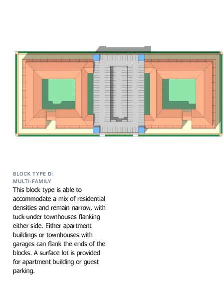
66 Residential Block Types
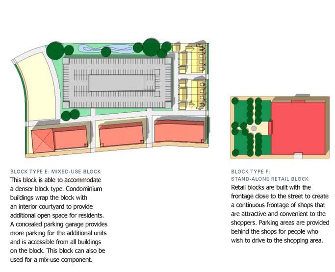
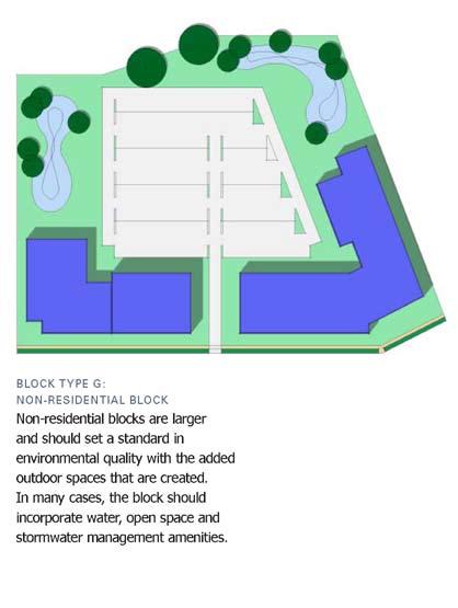
67 Non-Residential Block Types
68 Land Use and Development Initiatives Land Use + Heights Blocks + Development Types Building Types Landscape, Street Furniture, + Lighting Key Private Development Initiatives

69 Building Types
70 Land Use and Development Initiatives Land Use + Heights Blocks + Development Types Building Types Landscape, Street Furniture, + Lighting Key Private Development Initiatives
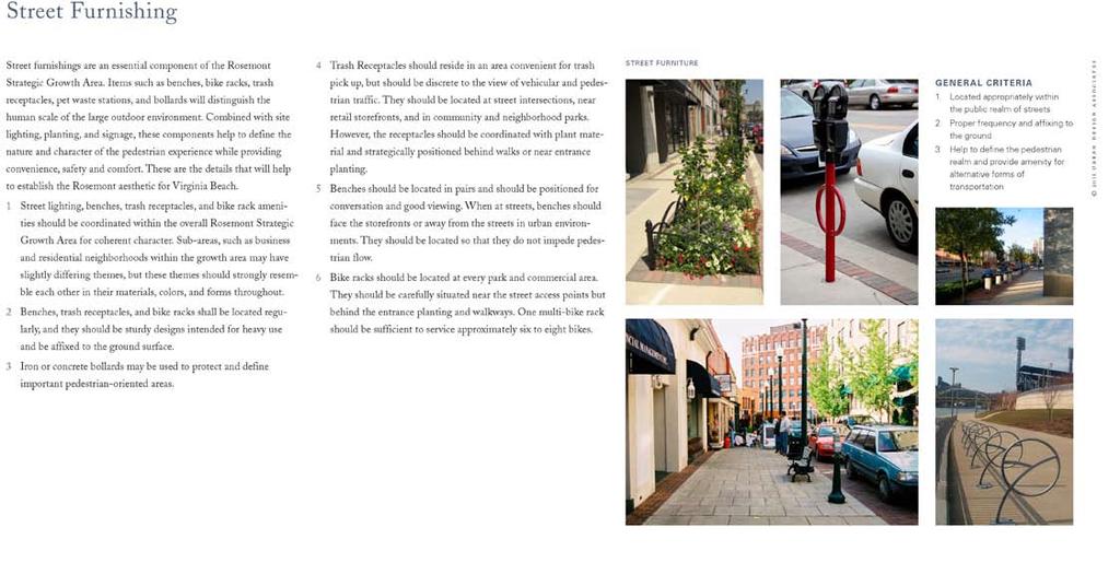
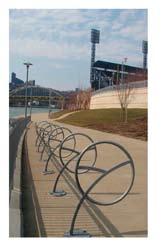
71 Street Furnishing
72 Land Use and Development Initiatives Land Use + Heights Blocks + Development Types Building Types Landscape, Street Furniture, + Lighting Key Private Development Initiatives
73 Birchwood Shopping Birchwood Shopping Redevelopment Program Use Multi-Family Residential Single-Family Residential Area (ac.) Residential Units Built Area (s.f.) Parking (sp.) sp./unit sp./unit Mixed-Use , sp./unit 3.5 sp./1,000 sf Retail , sp./1,000 sf Office Community Amenities Open Space 2.0 Stormwater 1.9 Total 23.7 ac. 514 units 210,000 s.f. 1,675 spaces
74
75

76
77 Bonney Road Redevelopment
78 Bonney Road Existing Alignment

79 Bonney Road Realigned
80 Thalia Road Public Initiatives Thalia Loehmanns Plaza Shopping Lynn Shores Drive Caren Drive Casselberry Lane Catalina Drive Malibu Little Neck Road Collins Square Shopping Virginia Beach Blvd. Bonney Road Sentara Way Flyover Virginia Beach Boulevard Improvements West Bonney Realignment Stormwater Utility South of the Credit Union Rosemont Road Interchange I Palace Green Blvd. Sentara Nursing Windsor Woods Presidential Blvd Teakwood Drive Princess Anne Plaza Baptist Preschool 7 South Rosemont Road Little Angels Montessori Lynnhaven 7 8 Rosemont Road Widening Virginia Beach Boulevard Stormwater Facility 9 Palace Green Pedestrian Bridge 10 East-West Trail along Potential Transit Corridor
81 Thalia Road Private Initiatives Thalia Loehmanns Plaza Shopping Lynn Shores Drive Caren Drive Casselberry Lane Catalina Drive Malibu 4 5 Little Neck Road Collins Square Shopping 3 1 Virginia Beach Blvd Bonney Road Birchwood Shopping Redevelopment Neighborhood Development Lynn Shores Redevelopment Palms Redevelopment Eastern Residential Neighborhood Western Residential Neighborhood Thalia Station Development I-264 Palace Green Blvd. Sentara Nursing Windsor Woods Presidential Blvd 11 Teakwood Drive Princess Anne Plaza Baptist Preschool South Rosemont Road Little Angels Montessori Lynnhaven 8 9 CarMax Redevelopment Nissan Redevelopment Virginia Beach Boulevard Office Development Rosemont Road Redevelopment
82 Phasing
83 Thalia Road Phase 1 Thalia Loehmanns Plaza Shopping Lynn Shores Drive Caren Drive Casselberry Lane Catalina Drive Malibu Little Neck Road Collins Square Shopping Virginia Beach Blvd. Bonney Road 1 2 I-264 Sentara Nursing 3 4 Little Angels Montessori Lynnhaven Palace Green Blvd. Windsor Woods Presidential Blvd Teakwood Drive Princess Anne Plaza Baptist Preschool South Rosemont Road 1 Sentara Way Fly Over 2 Improvements 3 Neighborhood Development 4 Runnymede Development
84 Thalia Road Phase 2 Thalia Loehmanns Plaza Shopping Lynn Shores Drive Caren Drive Casselberry Lane Catalina Drive Malibu Little Neck Road Collins Square Shopping 3 2 Virginia Beach Blvd. Bonney Road Bonney Road Realignment 2 New Mixed-Use Blocks North of Virginia Beach Boulevard 3 Lynn Shores Retail Redevelopment 4 Stormwater Facility South of the Credit Union 5 Sentara Way Redevelopment I-264 Palace Green Blvd. Sentara Nursing Windsor Woods Presidential Blvd 5 Teakwood Drive Princess Anne Plaza Baptist Preschool South Rosemont Road Little Angels Montessori Lynnhaven

85 Thalia Road Phase 3 Thalia Loehmanns Plaza Shopping Collins Square Shopping Lynn Shores Drive Caren Drive 9 11 Casselberry Lane Catalina Drive Malibu 8 10 Virginia Beach Blvd. 7 Little Neck Road 5 6 Bonney Road Rosemont Interchange Rosemont Road Widening 3 Jack Rabbit Storage Redevelopment 4 CarMAX Redevelopment 5 Nissan Redevelopment 6 Mexicana Redevelopment 7 Virginia Beach Office Development 8 Virginia Beach Stormwater Facility 9 Birchwood Shopping Redevelopment 10 Eastern Residential Neighborhood 11 Virginia Beach Boulevard I-264 Palace Green Blvd. Sentara Nursing Windsor Woods Presidential Blvd Teakwood Drive 3 Princess Anne Plaza Baptist Preschool South Rosemont Road 2 Little Angels Montessori Lynnhaven
86 Next Steps 1. Adoption Process for the Rosemont SGA plan Revisit zoning and subdivision regulations to permit rebuilding of SGA s Establish implementation and positioning strategy for all SGA s Create necessary development entities to enable public and private investment Include Sentara Way Flyover into Capital Improvement Projects Build remainder of Phase 1 public improvements in CIP Conclude due diligence on LRT Station Study feasibility and build Virginia Beach Boulevard into CIP
87 Thalia Road Little Neck Road Thalia Loehmanns Plaza Shopping Lynn Shores Drive Caren Drive Casselberry Lane Catalina Drive Malibu Collins Square Shopping Virginia Beach Blvd. Bonney Road I-264 Sentara Nursing Little Angels Montessori Lynnhaven Palace Green Blvd. Windsor Woods Presidential Blvd Teakwood Drive Princess Anne Plaza Baptist Preschool South Rosemont Road
Rosemont SGA virginia beach, va
 Rosemont SGA virginia beach, va Prepared for the City of Virginia Beach 14 March, 2011 urban design associates miles agency, rclco, urs, vhb & wpl urban design associates, miles agency, rclco, urs, vhb
Centerville SGA. virginia beach, va. Prepared for the City of Virginia Beach February,
 Centerville SGA virginia beach, va Phase 3 presentation Prepared for the City of 12-13 February, 2013 www.vbgov.com/centervilleplan urban design associates miles agency, rclco, urs, vhb & wpl A Three Phase
Transportation. Strategies for Action
 Transportation A major priority for the Overlake Neighborhood is to develop a multimodal transportation system. To achieve this system, a balance has to be found among travel, circulation and access needs;
Description of Preferred Alternative
 Chapter 2 Description of Preferred Alternative 2.1 Introduction This chapter of the programmatic Sammamish Town Center Sub-area Plan Final EIS provides a more detailed description of the Preferred Alternative
Gold Line Bus Rapid Transit Transit Oriented Development (BRTOD) Helmo Station Area Plan
 Helmo Station Area Plan") Appendix F Gold Line Bus Rapid Transit Transit Oriented Development (BRTOD) Helmo Station Area Plan Introduction and Purpose of the Plan The Gold Line Bus Rapid Transit facility is an eleven-mile dedicated
Appendix F Gold Line Bus Rapid Transit Transit Oriented Development (BRTOD) Helmo Station Area Plan Introduction and Purpose of the Plan The Gold Line Bus Rapid Transit facility is an eleven-mile dedicated
Civic Center District
 Civic Center District The Civic Center district is the civic and social heart of Warrenville, containing such public buildings as the City Hall, Warrenville Public Library, Police Station, Park District
Seneca Meadows. Block 4 Locate office, technology, and medical development adjacent to I Screen views of garage structures from I-270.
 Seneca Meadows Seneca Meadows has an industrial park in its southern end and a mixed-use employment area planned for the north end. The district benefits from extensive I-270 visibility, stream valley
GREENING THE BOULEVARD Master Plan Concepts for Venice Boulevard between Lincoln and Sawtelle
 GREENING THE BOULEVARD Katherine Spitz Associates Inc. 4212½ Glencoe Avenue Marina Del Rey, CA 90292 310 574 4460 Fax 574 4462 January 2008 Table of Contents Overview Proposed Design Improvements Illustration
Strategic Growth Area #1 Northampton Boulevard Corridor Area
 Strategic Growth Area #1 Northampton Boulevard Corridor Area Description Strategic Growth Area #1 has established itself as a major employment center in Southside Hampton Roads. Opportunities exist to
Establish a network of streetscaped vehicle and pedestrian routes that connect within and outside the Plan area.
 This Plan s urban design goals are to create an urban scale, walkable community with connections to transit, parks, and services and with amenities and facilities for residents and employees. The 1992
for Master Planned Development Framework Design Standards & Guidelines
 B L A C K D I A M O N D DE S I G N G U I D E L I N E S for Master Planned Development Framework Design Standards & Adopted June 18, 2009 Introduction and Purpose The Master Planned Development (MPD) Framework
SPRINGHILL LAKE TRANSIT VILLAGE
 Greenbelt Metro Area Sector Plan - Subarea Design Policies and Guidelines - Springhill Lake Transit Village 113 SPRINGHILL LAKE TRANSIT VILLAGE Residential Neighborhood and Village Center CONCEPT Springhill
Chapter 1: Introduction
 Chapter 1: Introduction The Penn Avenue Community Works Corridor Vision and Implementation Framework presents an integrated communitybased vision and a coordinated, long-term implementation framework for
Subregion 4 Central Avenue-Metro Blue Line Corridor Transit-Oriented Development (TOD) Implementation Project. Community Meeting April 27, 2011
 Implementation Project. Community Meeting April 27, 2011") Subregion 4 Central Avenue-Metro Blue Line Corridor Transit-Oriented Development (TOD) Implementation Project Community Meeting April 27, 2011 Overview Introduction to Subregion 4 TOD Implementation Program
Subregion 4 Central Avenue-Metro Blue Line Corridor Transit-Oriented Development (TOD) Implementation Project Community Meeting April 27, 2011 Overview Introduction to Subregion 4 TOD Implementation Program
DRAFT. 10% Common Open Space
 % OF CHARLOTTE IS CATEGORIZED AS A. LAND USES : Placeholder map displaying location of Place Type GOALS: Accommodate XX% of future growth. Provide a concentration of primarily commercial and civic activity
Northwest Rail Corridor and US 36 BRT Development Oriented Transit Analysis 4.4 STATION AREA FINDINGS
 4.4 STATION AREA FINDINGS Each station is different, and each one requires a separate set of recommendations based on the vision for the site. This section outlines an initial TOD strategy and recommendations
Westbound: A One-day Exploration of Growth
 Westbound: A One-day Exploration of Growth Frog Pond Area 2018 UGB Expansion Proposal June 13, 2018 Growing Out: UGB Asks Four cities submitted proposals to expand greater Portland s urban footprint by
EXISTING COMPREHENSIVE PLAN
 EXISTING COMPREHENSIVE PLAN Town Center Land Use Element: V. LAND USE POLICIES Town Center Mercer Island's business district vision as described in "Your Mercer Island Citizen-Designed Downtown" was an
Town Center. Block 5 Existing multifamily residential units are expected to remain.
 Area Guidelines Germantown s districts should be developed as distinct communities with unique features that are supported through the guidelines. The guidelines not only help distinguish these districts
VEHICULAR AND PEDESTRIAN CIRCULATION
 This perspective sketch communicates the intended character and quality of a proposed streetscape design. Locate benches near a major intersection where people tend to gather. Seating and lighting provide
Today Land & People. Northeast Nampa Gateway District. Employment. Land Use Characteristics. Demographics. Current Zoning
 Today Land & People Employment Major employers include Saint Alphonsus, the College of Western Idaho, the Auto Mall, Sorrento Lactalis and Walmart. 3,004 jobs in 2010 (COMPASS-CIM 2040 TAZ data) 4,345
New Partners for Smart Growth Conference February 5, 2010
 Dan Stroh, Planning Director City of Bellevue Planning and Community Development Bellevue, WA New Partners for Smart Growth Conference February 5, 2010 Summary of Project Long-range plan update for Bel-Red
Neighborhood Districts
 NEIGHBORHOOD DISTRICTS SEVEN MAIN DISTRICTS Neighborhood Districts While the Development Plan provides a broad-scale overview of the neighborhood, this section focuses on uses and relationships at the
A. Background Summary of Existing Challenges and Potential Possibilities. 1. Summary of Existing Assets and Potential Opportunities
 A. Background 1 A Main Street Master Plan Study was performed and completed in October of 2007. The study was initiated to review current land uses and development patterns along Main Street, from Parrish
appendix and street interface guidelines
 appendix five: building and street interface guidelines appendix 5 building and street interface guidelines BOULEVARDS Boulevards are generally characterized by higher levels of traffic movement at higher
1.0 VISION STATEMENT. December 6, PRINCIPLES
 Vision Statement Lincoln Regional Airport 1.0 VISION STATEMENT 1.1 City LOCATION of AND OVERVIEW The Easton Lincoln Place Land Use Master Plan identifies the principles, goals, policies, and standards
PLAN ELEMENTS WORKSHOP. April 5, 2016
 PLAN ELEMENTS WORKSHOP April 5, 2016 needs more housing. But there is no one-size fits-all solution. Every neighborhood has its own character. In some places, density is not only appropriate it is badly
PUBLIC RIGHT-OF-WAY IN THIS CHAPTER PUBLIC REALM
 PUBLIC RIGHT-OF-WAY This section provides design guidelines for improvements in the public right-of-way. The public right-of-way refers to streets, sidewalks, non-vehicular thoroughfares, parks and greenways
14 October 10, 2012 Public Hearing APPLICANT: MPB, INC
 14 October 10, 2012 Public Hearing APPLICANT: MPB, INC PROPERTY OWNER: MUNDEN & ASSOCIATES, LP STAFF PLANNER: Karen Prochilo REQUEST: Conditional Change of Zoning (AG-1 & AG-2 to Conditional O-2) ADDRESS
ITA and Vicinity Master Plan Update
 1 ITA and Vicinity Master Plan Update PHASE 3 SEPTEMBER 27, 2017 Three Phase Process 2 Phase 1 - Understanding October 13th Public Meeting Phase 2A - Exploring Ideas November 17th Public Meeting Phase
Little Neck Planning Area
 Little Neck Planning Area Current Reality The Little Neck Planning Area is characterized by established residential neighborhoods, Town Center and Pembroke. The Eastern and Western Branches of the Lynnhaven
URBAN DESIGN BRIEF URBAN DESIGN BRIEF 721 FRANKLIN BLVD, CAMBRIDGE August 2018
 URBAN DESIGN BRIEF URBAN DESIGN BRIEF 721 FRANKLIN BLVD, CAMBRIDGE August 2018 DESIGN BRIEF CONTENTS PART A 1.0 INTRODUCTION 2.0 DESCRIPTION & ANALYSIS OF SITE CONTEXT 3.0 DESIGN CONSTRAINTS AND OPPORTUNITIES
Lehigh Acres Land Development Regulations Community Planning Project
 Lehigh Acres Land Development Regulations Planning Effort Summary In July, 2010 Commissioner Frank Mann invited the Lehigh Acres community to start discussing how to achieve their recently adopted community
Glenborough at Easton Land Use Master Plan
 Vision Statement Sunrise Blvd. Hazel Ave. Prairie City Rd. Gencorp Property Lincoln Regional Airport 1.0 VISION STATEMENT The identifies City of the principles, goals, policies, and standards Lincoln that
Policies and Code Intent Sections Related to Town Center
 Policies and Code Intent Sections Related to Town Center The Town Center Vision is scattered throughout the Comprehensive Plan, development code and the 1994 Town Center Plan. What follows are sections
FORMER CANADIAN FORCES BASE (CFB) ROCKCLIFFE SECONDARY PLAN. Official Plan Amendment XX to the Official Plan for the City of Ottawa
 ROCKCLIFFE SECONDARY PLAN. Official Plan Amendment XX to the Official Plan for the City of Ottawa") FORMER CANADIAN FORCES BASE (CFB) ROCKCLIFFE SECONDARY PLAN Official Plan Amendment XX to the Official Plan for the City of Ottawa 1 INDEX THE STATEMENT OF COMPONENTS PART A THE PREAMBLE PAGE Purpose...
FORMER CANADIAN FORCES BASE (CFB) ROCKCLIFFE SECONDARY PLAN Official Plan Amendment XX to the Official Plan for the City of Ottawa 1 INDEX THE STATEMENT OF COMPONENTS PART A THE PREAMBLE PAGE Purpose...
DRAFT. October Wheaton. Design Guidelines
 October 2011 DRAFT Wheaton Design Guidelines 2 Draft - Design Guidelines - Wheaton Sector Plan Contents 04 Section 1: Introduction 06 Section 2: Context 08 Section 3: Design Guidelines 09 Goal 1: Create
Preliminary Recommendations Tk Takoma/Langley Crossroads Sector Plan
 Preliminary Recommendations Tk Takoma/Langley Crossroads Sector Plan Vision is to achieve a Transit Oriented, pedestrian friendly Community that Celebrates and builds upon the cultural Diversity of the
INDEPENDENCE BOULEVARD AREA PLAN
 INDEPENDENCE BOULEVARD AREA PLAN Public Meeting October 28, 2008 Tonight s Agenda Introduction 4:00 4:05 Tom Warshauer Presentation 4:05 5:00 Blake Drury Group Exercises 5:00 5:50 All Wrap Up & Next Steps
Sahuarita District & Phase 1 Master Plan. Town Council December 11, 2017
 Sahuarita District & Phase 1 Master Plan Town Council December 11, 2017 Visioning Study Visioning Process Advisory Group Meetings Community Questionnaire Town Center Case Studies Community Analysis The
MONTGOMERY COUNTY METRO STATION AREA DESIGN CHARRETTE
 MONTGOMERY COUNTY METRO STATION AREA DESIGN CHARRETTE Shady Grove Metro Station Area Charrette Closing Presentation October 25-28, 2000 MONTGOMERY COUNTY, MD M-NCPPC Design Collective, Inc. Architects
Danvers High Street I-1 District Study
 Danvers High Street I-1 District Study Presentation of Final Recommendations Planning Board Presentation June 26 th, 2018 1 Introductions Metropolitan Area Planning Council Sam Cleaves AICP, Principal
Clairtrell Area Context Plan
 Clairtrell Area Context Plan March 2005 Urban Development Services City Planning Contents 1. Introduction... 4 2. Development Structure... 6 2.1 Streets... 7 2.1.1 Sheppard Avenue and Bayview Avenue...
PINE CURVE REZONING. Property does not meet criteria for open space preservation and is not a candidate for a park
 PINE CURVE REZONING BACKGROUND Purchased as two parcels in 2001 and 2002 Annexed and Zoned Greater Downtown District Historic Center September 25, 2002 and October 7, 2002 WHAT THE PROJECT IS AND IS NOT
FLORIN ROAD CORRIDOR Site Plan and Design Review Guidelines Checklist
 FLORIN ROAD CORRIDOR Site Plan and Design Review Guidelines Checklist Applicant s Name: Project Address: Phone: Email: Applicant shall fill out the design guidelines checklist for all guidelines applicable
LOW DENSITY RESIDENTIAL
 LOW DENSITY RESIDENTIAL Corner lots with coach houses to increase diversity, provide unity to the streetscape and increase eyes on the street. Garages and ancillary units accessed via rear lanes. Parking
Throughout. square. (Crystal City Vision Plan 2050)
") 1: Terms related to the PSMP document 1 public space (see also public realm, civic space) An open space designated on the regulating plan, accessible to all, including Plazas, Mini Parks, and Neighborhoods
1: Terms related to the PSMP document 1 public space (see also public realm, civic space) An open space designated on the regulating plan, accessible to all, including Plazas, Mini Parks, and Neighborhoods
Streets Vision
 streets 86 2.9 Vision : The Most Prevalent and Important Public Spaces Fixed routes of human travel have served as corridors for commerce and places for human interaction from the earliest trails and foot
This Review Is Divided Into Two Phases:
 Semiahmoo Town Centre Review The purpose of this review: To review the Semiahmoo Town Centre Concept Plan, originally approved in 1993, to ensure that this centre will continue to serve the needs of South
Courthouse Square Planning & Urban Design Study. Courthouse Square Working Group #13 October 15, 2014
 Courthouse Square Planning & Urban Design Study Courthouse Square Working Group #13 October 15, 2014 1 Courthouse Square Process Working Group Community Courthouse Square Advisory Groups & Civic Associations
7Page 91 CLEMMONS COMMUNITY COMPASS 7 COMMUNITY CHARACTER
 7 Community Character The beauty of Clemmons won t necessarily be a reflection of our past, but our future. This quote from Comprehensive Plan Steering Committee member Wayne Dodson captures the essence
2.5 Roads. Loading and service areas adjacent to Highway 401 should be screened through architectural walls and/or landscape buffer planting.
 N HIGHWAY OFF RAMP 2.5 Roads A legible road network with a clear hierarchy will help create a connected community, both within and surrounding the Milton Heights. The following section outlines the proposed
Silverdale Regional Center
 Silverdale Regional Center Vision for Silverdale Regional Center The Silverdale Regional Center Plan (Plan) will guide the evolution of the Silverdale Regional Center from a collection of strip malls and
Forest Hills Improvement Initiative A Partnership for Building a Better Community. Use & Design Guidelines September 23, 2008
 Forest Hills Improvement Initiative A Partnership for Building a Better Community City of Boston Thomas M. Menino, Mayor Emerging Community Vision p. 2 Site Use & Design Guidelines p. 3 to 21 Arborway
COMPLETE GREEN STREET CHECKLIST
 COMPLETE GREEN STREET CHECKLIST This document was developed to dissect the structure of an urban street and explore opportunities to make our streets more complete while also integrating green street strategies.
PROPOSED REDEVELOPMENT OF THE GLEN ABBEY GOLF CLUB. STREETSCAPE DESIGN STUDY (excerpt from the Urban Design Brief) TOWN OF OAKVILLE.
 TOWN OF OAKVILLE.") PROPOSED REDEVELOPMENT OF THE GLEN ABBEY GOLF CLUB STREETSCAPE DESIGN STUDY (excerpt from the Urban Design Brief) TOWN OF OAKVILLE OCTOBER, 2016 for 2.4.2 STREETS Streets are the single largest component
PROPOSED REDEVELOPMENT OF THE GLEN ABBEY GOLF CLUB STREETSCAPE DESIGN STUDY (excerpt from the Urban Design Brief) TOWN OF OAKVILLE OCTOBER, 2016 for 2.4.2 STREETS Streets are the single largest component
Executive Summary. NY 7 / NY 2 Corridor
 Executive Summary NY 7 / NY 2 Corridor Transportation and Land Use Study December 2005 Prepared for: Town of Colonie Capital District Transportation Committee Prepared by: Introduction: Land use decisions
3. VISION AND GOALS. Vision Statement. Goals, Objectives and Policies
 Vision Statement Queen Creek s interconnected network of parks, trails, open spaces and recreation opportunities provide safe and diverse activities and programs that sustain its unique, small town, equestrian
LEED-ND 101: Practical Strategies for Achieving Sustainability Goals. Travis Parker Lakewood Planning Director
 LEED-ND 101: Practical Strategies for Achieving Sustainability Goals Travis Parker Lakewood Planning Director Metro Vision Idea Exchange Oct 11, 2012 West Corridor Stations West Corridor Overview West
Planning Board Briefing
 Planning Board Briefing Why Now? The Sector Plan Implementation Chapter States: Before Stage 1 begins, the following must occur: Approval of the Sectional Map Amendment. Approval of the Greater Lyttonsville
Review of Opportunity Area C Draft Comprehensive Plan and Draft BOS Follow-On Motions. Special Working Group Meeting March 4, 2015
 Review of Opportunity Area C Draft Comprehensive Plan and Draft BOS Follow-On Motions Special Working Group Meeting March 4, 2015 The slides that follow identify where the draft Comprehensive Plan has
Midtown Greenway Land Use and Development Plan Executive Summary
 Midtown Greenway Land Use and Development Plan Executive Summary Introduction The Midtown Greenway Land Use and Development Plan sets policy direction for land use and development in the Midtown Greenway
7.0 OPEN SPACE 7.1 OPEN SPACE DEDICATION CHAPTER 7: OPEN SPACE
 7.0 OPEN SPACE The intent of these requirements is to allow for the usage of centrally located unencumbered land as neighborhood open spaces and not to permit the use of leftover or otherwise unusable
SUMMERSIDE / MT. CARMEL REINVESTMENT CORRIDOR COMMUNITY DEVELOPMENT STRATEGY
 SUMMERSIDE / MT. CARMEL REINVESTMENT CORRIDOR COMMUNITY DEVELOPMENT STRATEGY FEBRUARY 2013 I. Location of the Summerside/Mt. Carmel Reinvestment Corridor The Summerside/Mt. Carmel Reinvestment Corridor
The University District envisions, in its neighborhood
 Envisioning the University District Link Light Rail in Seattle s neighborhoods CIY OF SEALE CONCEP-LEVEL SAION AREA PLANNING RECOMMENDAION RESOLUION # 30165 EXHIBI L Vision 08.2000 he University District
Shared Principles and Emerging Plan Directions
 Shared Principles and Emerging Plan Directions Introduction Since the Fairfield Neighbourhood planning process launched in June 2016, we have heard from many residents, businesses, groups and other people
Agenda. 7 Wright Crescent Urban Design Study. Public Meeting and Urban Design Workshop. 1 INTRODUCTION AND BACKGROUND (City of Kingston)
") Urban Design Study Public Meeting and Urban Design Workshop October 02, 2013 Agenda 1 INTRODUCTION AND BACKGROUND (City of Kingston) 2 URBAN DESIGN STUDY PRESENTATION (Antonio Gomez-Palacio, DIALOG) 3
Urban Design Study Public Meeting and Urban Design Workshop October 02, 2013 Agenda 1 INTRODUCTION AND BACKGROUND (City of Kingston) 2 URBAN DESIGN STUDY PRESENTATION (Antonio Gomez-Palacio, DIALOG) 3
Cobb County Design Guidelines Mableton Parkway & Veterans Memorial Highway Community Design Workshop January 12, 2017
 Community Design Workshop January 12, 2017 Agenda Opening Remarks / Introductions Scope of Work Existing Conditions Key Issues / Opportunities VPS Summary Draft Vision & Goal Statement Implementation Concepts
SYRINGA VALLEY SPECIFIC PLAN NARRATIVE
 SYRINGA VALLEY SPECIFIC PLAN NARRATIVE Introduction With this application, Pleasant Valley South LLC ( Pleasant Valley ) seeks the City of Boise s approval of a new Specific Plan Ordinance to be added
Section 9 NEIGHBORHOOD DESIGN
 Section 9 NEIGHBORHOOD DESIGN City of Lancaster Comprehensive Plan D u n k i n, S e f k o & A s s o c i a t e s, I n c. NEIGHBORHOOD DESIGN INTRODUCTION There are many ways in which a neighborhood can
Access Management: An Overview
 Figures 1-5 Below Evolution of development along a highway. In the early stages, land along the road is used for farming with little traffic generated. As time passes, the highway corridor becomes a de
Millbrae TOD #2 Project Analysis
 Millbrae TOD #2 Project Analysis Project Description A Site Development Permit and Conditional Use Permit are proposed to allow for a mixed-use transitoriented development on approximately 9 Acres located
BROOKLYN PARK / 85TH AVE LRT STATION CDI DEVELOPMENT GUIDELINES DRAFT
 August 2018 Page intentionally left blank The Brooklyn Park Library adjacent to the 85th Ave LRT Station Area. OVERVIEW The Blue Line LRT Extension / Bottineau corridor offers a unique opportunity to leverage
Clair-Maltby Community visioning
 Clair-Maltby Community visioning workshop #1 Summary April 27th, 2017 Table of Contents INTRODUCTIon 1 PURPOSE 1 CONSULTATION STRUCTURE 2 PARTICIPANT FEEDBACK 3 VISIONING EXERCISE 8 ONLINE SURVEY RESULTS
GPA FALL 2017 CONFERENCE
 Change in Doraville Doraville at the beginning of a new era Design Doraville (Comp. Plan) adopted in 2016 Doraville Town Center Masterplan LCI (2005) Downtown Doraville Masterplan LCI (2010) 2014 Adoption
Silver Line CPAM UPDATE. Transportation and Land Use Committee October 14, 2016
 Silver Line CPAM UPDATE Transportation and Land Use Committee October 14, 2016 Purpose Recap Project History and Map Changes Provide Overview of CPAM Components Discuss Transportation Impacts Discuss Fiscal
BURTON STATION STRATEGIC GROWTH AREA PLAN UPDATE PUBLIC MEETING 3/26/18
 BURTON STATION STRATEGIC GROWTH AREA PLAN UPDATE PUBLIC MEETING 3/26/18 1 WHERE WE ARE? 2 PRIMARY OBJECTIVES OF THE PLAN UPDATE 1. Update the land use designation for Burton Station Village to reflect
WRAPS Site Studies. Cooper, Robertson & Partners. December 8, Page 1
 WRAPS Page 1 Realigned N. Pierce Street & Extension Base 1 FOR PRESENTATION TOTAL GSF OFFICE 346,000 RESIDENTIAL 795,000 POTENTIAL RETAIL 40,000 TOTAL 1,181,000 795 DU Open Space (Development Parcels)
Urban Development Areas James City County
 24 Urban Development Areas James City County UDA Needs Profile: Anderson s Corner James City County has designated 11 UDAs within its boundaries, and the Anderson s Corner Mixed Use Area is located along
Hockessin Community Redevelopment Plan
 Hockessin Community Redevelopment Plan 3.1 Introduction The Community Redevelopment Plan for the Village of Hockessin is the result of the people s vision for a distinct village center that serves as the
ANCHOR TO ANCHOR. Rescale the street to create an iconic boulevard.
 ANCHOR TO ANCHOR Rescale the street to create an iconic boulevard. UR NE ER UV GO NE LA OBJECTIVES 1. Maintain appropriate traffic flow and prioritize commercial curb access 2. Mark gateways at the street
RESEDA - WEST VAN NUYS COMMUNITY PLAN
 RESEDA - WEST VAN NUYS COMMUNITY PLAN Executive Summary As part of the initial outreach effort, the Department of City Planning hosted two workshops for the Reseda-West Van Nuys Community Plan Area during
2040 Long Range Transportation Plan
 2040 Long Range Transportation Plan Adopted: April 15, 2013 APPENDIX D HIGHWAY NEEDS PLAN PROJECTS FREDERICKSBURG Existing and Committed Projects Fall Hill Avenue/Mary Washington Blvd. (Fredericksburg)
SECTION TWO: Urban Design Concepts
 SECTION TWO: Urban Design Concepts The Gardnerville Plan for Prosperity shapes economic opportunities presented by regional growth. The Urban Design Concepts provide policies and concepts for land use,
KASPER. City of Georgetown, Texas PUD Planned Unit Development. December 30, 2015 Revised January 27, 2016
 KASPER City of Georgetown, Texas PUD Planned Unit Development December 30, 2015 Revised January 27, 2016 Applicant: Sentinel Land Company, LLC 4910 Campus Drive Newport Beach, CA Prepared by: SEC Planning
Urban Design Guidelines
 Potomac Yard Urban Design Guidelines ALTERNATIVE CONCEPT PLAN Submitted by: Commonwealth Atlantic Properties Prepared by: Cooper, Robertson & Partners Cunningham + Quill Oculus cristopher consultants,
OPEN SPACE TYPES. SIZE 8 acres. SIZE 20 acres. SIZE 1 acre
 TYPICAL CHARACTERISTICS OPEN SPACE TYPES OPEN SPACE TYPES The neighborhood contains an extensive variety of open space types. Most of these spaces incorporate multiple uses and activities, so that each
Draft Memorandum #1: Goals and Vision for Revitalization
 Keizer Revitalization Plan Draft Memorandum #1: Goals and Vision for Revitalization Submitted to: City of Keizer April 12, 2018 (revised) Prepared By: Angelo Planning Group and Otak, Inc. Project No. 17482.A
2418 KHALSA GATE, OAKVILLE URBAN DESIGN BRIEF APPLICATION FOR ZONING BY-LAW AMENDMENT. Prepared for: Golden Arch Tech Investment Corporation
 APPLICATION FOR ZONING BY-LAW AMENDMENT Prepared for: Golden Arch Tech Investment Corporation NOVEMBER 2015 I TABLE OF CONTENTS INTRODUCTION... 1 SECTION 1... 2 Contextual Analysis... 2 Oakville Official
Wheaton CBD & Vicinity Sector Plan D E S I G N G U I D E L I N E S
 Wheaton CBD & Vicinity Sector Plan D E S I G N G U I D E L I N E S 1 a b s t r a c t This document contains the design guidelines the property owners, community members, and planners should use to implement
1 Adapted from the Statewide Transit-Oriented Development Study by CalTrans, 2006
 APPENDIX C: LAND USE PLANNING FOR ENHANCED RAIL SERVICE 72 BACKGROUND One of the consistent themes heard from localities in the Route 29 corridor Planning Forums was the need for expanding rail service
Section4 Design Vision & Implementation Plan
 Section4 Design Vision & Implementation Plan W Woodschurch Rd 4.1 Design Focus Areas The Framework Plan is simply the starting point for directing the design and implementation of a wide range of transportation
City of Hermosa Beach Administrative Policy #
 City of Hermosa Beach Administrative Policy # SUBJECT: Living Streets Policy Date: Approved by: City Council Authority: Public Works Department & Community Development Department Mayor, PURPOSE The City
Figure 3-1: Public Realm Plan
 3 Public Realm Figure 3-1: Public Realm Plan 3.1 Public Realm Concept The public realm concept for the Little Mountain site integrates a clear and accessible movement network with public spaces for social
South Davis County COMMUNITY SPOTLIGHT
 South Davis County COMMUNITY SPOTLIGHT Davis/SLC Community Connector Bus Rapid Transit line connecting SLC & Davis County RTP Phase 1 Project Generate 3,100 average weekday riders Relieve congestion on
Long Branch-Wayne Local Park Renovation Project
 Montgomery Parks Long Branch-Wayne Local Park Renovation Project Community Meeting #2 September 20, 2016 Oak View Elementary School 7:00-9:00 PM Welcome / Team Introductions M-NCPPC (Montgomery Parks)
Hopkins. Development Guidelines May Overview. Sponsored by: Blake Road Corridor Collaborative City of Hopkins
 Hopkins Blake Road LRT Station Area Development Guidelines May 2015 Sponsored by: Blake Road Corridor Collaborative City of Hopkins Overview Hopkins is a dynamic community of over 17,000 residents located
Public input has been an important part of the plan development process.
 Lakewood s Comprehensive Plan recognizes that transportation helps shape the community, and that the way the community provides for the safe and efficient movement of people affects the character of the
4 C OMMUNITY D ISTRICTS
 4 C OMMUNITY D ISTRICTS N ew development in the Area will include many different types of land uses, including a destination retail area that attracts people from all over the region; recreation opportunities
Further input invited as Colchester Growth Strategy nears final phase
 IUE 3 / NOVEMBER 2015 Further input invited as Colchester Growth trategy nears final phase trathcona County is seeking public feedback as it enters the final phase of work on a Growth Management trategy