5137 & 5145 Colfax Avenue
|
|
|
- Virgil Newton
- 6 years ago
- Views:
Transcription

1 5137 & 5145 Colfax Avenue Valley Village Owner/User, Investor or Development Site for Sale Offered at $2,750,000 Total Lot Size 16,713 SF Total Building Size 6,181 SF 5137 Colfax Avenue Office Building Lot Size 8,486 sf Property Size 2,778 sf Currently occupied by owner Multiple offices, kitchen and bathrooms 5145 Colfax Avenue Mixed Use Lot Size 8,227 sf Property Size 3,403 sf Delivered vacant Triplex and Restaurant Space


2 5137 & 5145 COLFAX AVENUE VALLEY VILLAGE Two separate parcels in prime Valley Village are presented for sale both individually and combined Colfax Ave is a built out office space with multiple offices, bathrooms, kitchen and conference room with plenty of on-site parking in front and in back. Also, a month-to-month billboard lease with Viacom generating $250 per month is provided. Will be delivered vacant Colfax Ave is also being delivered vacant. The property provides 3 individual apartments and a front restaurant space. The 3 apartments have two large 1 bed, 1 bath units and an even larger 4 bed, 3 bath unit. The front restaurant space is approximately 1,000 square feet with great street frontage. Both properties currently zoned (Q) C2-1VL. The Q brings the zoning down to C1.5-1VL. The properties also fall under the Valley Village Specific Plan that limits height to 36 feet. Build 41 units by right or 14 Small Lot Homes. Alley access provides further density and an ingress/egress option. Phase 1 environmental reports have been done for both properties and both show clean history with no limitation to construction. These properties are being provided free and clear of debt with tremendous upside value and development potential. Buyers are to verify all potential development options. PRICE $2.75mil


3 5137 COLFAX AVENUE OFFICE BUILDING Lot Size 8,486 sf Property Size 2,778 sf Currently Occupied by Owner Multiple offices, Kitchen and Bathrooms 5145 COLFAX AVENUE MIXED USE Lot Size 8,227 sf wine room pool Property Size 3,403 sf Delivered Vacant Triplex and Restaurant Space

4 FLOOR LAYOUTS


5 Assecor Map GETTING TO KNOW VALLEY VILLAGE The community of Valley Village was formed in 1939 and was originally part of rth Hollywood. A secession drive was established in 1991 to officially secede from rth Hollywood, part of a precedent that swept through the San Fernando Valley beginning in the 1980s; urban blight was the main cause for many neighborhoods. Secession leaders stated that the move "was more than an attempt to boost property values, and it had nothing to do with ethnic demographics. It was one economic level seeking to have its own identity." Residents also cited historical precedent for the change in that the original 1939 articles of incorporation cited the name and inspired the Valley Village post office on Magnolia Boulevard. Valley Village was officially recognized as a separate community by the Los Angeles City Council in 1991.
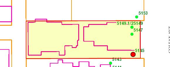
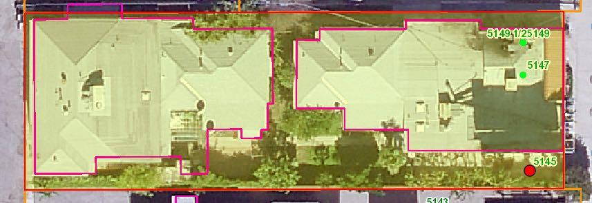
6 City of Los Angeles Department of City Planning Page 1 of 4 6/1/2015 PARCEL PROFILE REPORT (modified version) PROPERTY ADDRESSES 5149 N COLFAX AVE 5147 N COLFAX AVE 5145 N COLFAX AVE /2 N COLFAX AVE ZIP CODES RECENT ACTIVITY CASE NUMBERS CPC GPC ORD ORD ORD SA5520 ZA CUB PKG-5561 Address/Legal Information PIN Number 171B Lot/Parcel Area (Calculated) 8,227.4 (sq ft) Thomas Brothers Grid PAGE GRID H2 Assessor Parcel. (APN) Tract TR 7378 Map Reference M B /84 Block Lot FR 181 Arb (Lot Cut Reference) Map Sheet Jurisdictional Information Community Plan Area Area Planning Commission Neighborhood Council Council District 171B169 rth Hollywood - Valley Village South Valley Valley Village Census Tract # LADBS District Office Planning and Zoning Information Special tes Zoning Zoning Information (ZI) General Plan Land Use General Plan Footnote(s) Hillside Area (Zoning Code) Baseline Hillside Ordinance CD 2 - Paul Krekorian Van Nuys [Q]C2-1VL ZI-2443 Neighborhood Conservation ICO - Valley Village Neighborhood Office Commercial Yes Baseline Mansionization Ordinance Specific Plan Area Special Land Use / Zoning Design Review Board Historic Preservation Review Historic Preservation Overlay Zone Other Historic Designations Other Historic Survey Information Mills Act Contract POD - Pedestrian Oriented Districts CDO - Community Design Overlay NSO - Neighborhood Stabilization Overlay Streetscape Sign District Adaptive Reuse Incentive Area CRA - Community Redevelopment Agency Central City Parking Downtown Parking Building Line Valley Village 500 Ft School Zone Active: rth Hollywood High School 500 Ft Park Zone Assessor Information Assessor Parcel. (APN) APN Area (Co. Public Works)* Use Code (ac) Assessed Land Val. $650,000 Assessed Improvement Val. $275,000 Last Owner Change 08/13/14 Last Sale Amount $925,009 Tax Rate Area 13 Deed Ref. (City Clerk) Building Store and Residential Combination Year Built 1940 Building Class Number of Units 4 Number of Bedrooms 0 Number of Bathrooms 0 DX Building Square Footage 3,403.0 (sq ft) Building 2 data for building 2 Building 3 data for building 3 Building 4 data for building 4 Building 5 data for building 5 Additional Information Airport Hazard Coastal Zone Farmland Very High Fire Hazard Severity Zone Fire District. 1 Flood Zone Watercourse Hazardous Waste / Border Zone Properties Methane Hazard Site High Wind Velocity Areas Special Grading Area (BOE Basic Grid Map A-13372) Oil Wells Seismic Hazards Active Fault Near-Source Zone Nearest Fault (Distance in km) Nearest Fault (Name) Region Fault Type Area t Mapped Hollywood Fault Slip Rate (mm/year) Transverse Ranges and Los Angeles Basin Slip Geometry Left Lateral - Reverse - Oblique Slip Type B Poorly Constrained Down Dip Width (km) Rupture Top Rupture Bottom Dip Angle (degrees) Maximum Magnitude Alquist-Priolo Fault Zone Landslide Liquefaction Tsunami Inundation Zone Economic Development Areas Business Improvement District Renewal Community Revitalization Zone State Enterprise Zone State Enterprise Zone Adjacency Targeted Neighborhood Initiative Yes This report is subject to the terms and conditions as set forth on the website. For more details, please refer to the terms and conditions at zimas.lacity.org (*) - APN Area is provided "as is" from the Los Angeles County's Public Works, Flood Control, Benefit Assessment. zimas.lacity.org cityplanning.lacity.org
7 City of Los Angeles Department of City Planning Page 2 of 4 6/1/2015 PARCEL PROFILE REPORT (modified version) Public Safety Police Information Bureau Division / Station Fire Information Valley Reporting District 1545 Division 3 Station Batallion 14 District / Fire Red Flag Restricted Parking rth Hollywood 60 This report is subject to the terms and conditions as set forth on the website. For more details, please refer to the terms and conditions at zimas.lacity.org (*) - APN Area is provided "as is" from the Los Angeles County's Public Works, Flood Control, Benefit Assessment. zimas.lacity.org cityplanning.lacity.org
8 CASE SUMMARIES te: Information for case summaries is retrieved from the Planning Department's Plan Case Tracking System (PCTS) database. Case Number: CPC GPC Required Action(s): GPC-GENERAL PLAN/ZONING CONSISTENCY (AB283) Project Descriptions(s): PLAN AND ZONE CONSISTENCY - NORTH HOLLYWOOD (JON PERICA) Case Number: ZA CUB Required Action(s): CUB-Conditional Use Beverage-Alcohol Project Descriptions(s): Data t Available DATA NOT AVAILABLE ORD ORD ORD SA5520 PKG-5561 This report is subject to the terms and conditions as set forth on the website. For more details, please refer to the terms and conditions at zimas.lacity.org (*) - APN Area is provided "as is" from the Los Angeles County's Public Works, Flood Control, Benefit Assessment. zimas.lacity.org cityplanning.lacity.org
![ZIMAS PUBLIC Generalized Zoning 06/01/2015 City of Los Angeles Department of City Planning Address: 5149 N COLFAX AVE Tract: TR 7378 Zoning: [Q]C2-1VL](/docs-images/76/73654787/images/9-0.jpg "APN: 2355005037 Block: General Plan: Neighborhood Office Commercial PIN #: 171B169 462 Lot: FR 181 Arb: Streets Copyright (c) Thomas Brothers Maps, Inc.")
9 ZIMAS PUBLIC Generalized Zoning 06/01/2015 City of Los Angeles Department of City Planning Address: 5149 N COLFAX AVE Tract: TR 7378 Zoning: [Q]C2-1VL APN: Block: General Plan: Neighborhood Office Commercial PIN #: 171B Lot: FR 181 Arb: Streets Copyright (c) Thomas Brothers Maps, Inc.
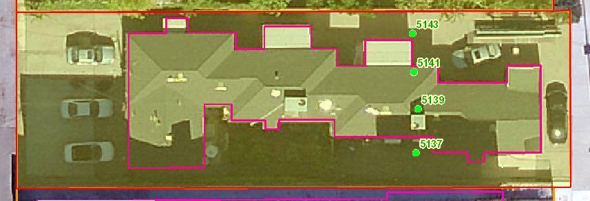
10 City of Los Angeles Department of City Planning Page 1 of 4 6/1/2015 PARCEL PROFILE REPORT (modified version) PROPERTY ADDRESSES 5143 N COLFAX AVE 5141 N COLFAX AVE 5139 N COLFAX AVE 5137 N COLFAX AVE ZIP CODES RECENT ACTIVITY CASE NUMBERS CPC GPC ORD ORD ORD SA5520 AFF Address/Legal Information PIN Number 171B Lot/Parcel Area (Calculated) 8,486.2 (sq ft) Thomas Brothers Grid PAGE GRID H2 Assessor Parcel. (APN) Tract TR 7378 Map Reference M B /84 Block Lot 182 Arb (Lot Cut Reference) Map Sheet Jurisdictional Information Community Plan Area Area Planning Commission Neighborhood Council Council District 171B169 rth Hollywood - Valley Village South Valley Valley Village Census Tract # LADBS District Office Planning and Zoning Information Special tes Zoning Zoning Information (ZI) General Plan Land Use General Plan Footnote(s) Hillside Area (Zoning Code) Baseline Hillside Ordinance Baseline Mansionization Ordinance CD 2 - Paul Krekorian Van Nuys [Q]C2-1VL ZI-2443 Neighborhood Conservation ICO - Valley Village Neighborhood Office Commercial Yes Specific Plan Area Special Land Use / Zoning Design Review Board Historic Preservation Review Historic Preservation Overlay Zone Other Historic Designations Other Historic Survey Information Mills Act Contract POD - Pedestrian Oriented Districts CDO - Community Design Overlay NSO - Neighborhood Stabilization Overlay Streetscape Sign District Adaptive Reuse Incentive Area CRA - Community Redevelopment Agency Central City Parking Downtown Parking Building Line Valley Village 500 Ft School Zone Active: rth Hollywood High School 500 Ft Park Zone Assessor Information Assessor Parcel. (APN) APN Area (Co. Public Works)* Use Code (ac) Assessed Land Val. $328,000 Assessed Improvement Val. $397,000 Last Owner Change 07/14/14 Last Sale Amount $725,007 Tax Rate Area 13 Deed Ref. (City Clerk) Building Office Building Year Built 1941 Building Class D6 Number of Units 0 Number of Bedrooms 0 Number of Bathrooms 0 Building Square Footage 2,778.0 (sq ft) Building 2 data for building 2 Building 3 data for building 3 Building 4 data for building 4 Building 5 data for building 5 Additional Information Airport Hazard Coastal Zone Farmland Very High Fire Hazard Severity Zone Fire District. 1 Flood Zone Watercourse Hazardous Waste / Border Zone Properties Methane Hazard Site High Wind Velocity Areas Special Grading Area (BOE Basic Grid Map A-13372) Oil Wells Seismic Hazards Active Fault Near-Source Zone Nearest Fault (Distance in km) Nearest Fault (Name) Region Fault Type Area t Mapped Hollywood Fault Slip Rate (mm/year) Transverse Ranges and Los Angeles Basin Slip Geometry Left Lateral - Reverse - Oblique Slip Type B Poorly Constrained Down Dip Width (km) Rupture Top Rupture Bottom Dip Angle (degrees) Maximum Magnitude Alquist-Priolo Fault Zone Landslide Liquefaction Tsunami Inundation Zone Economic Development Areas Business Improvement District Renewal Community Revitalization Zone State Enterprise Zone Yes This report is subject to the terms and conditions as set forth on the website. For more details, please refer to the terms and conditions at zimas.lacity.org (*) - APN Area is provided "as is" from the Los Angeles County's Public Works, Flood Control, Benefit Assessment. zimas.lacity.org cityplanning.lacity.org
11 City of Los Angeles Department of City Planning Page 2 of 4 6/1/2015 PARCEL PROFILE REPORT (modified version) State Enterprise Zone Adjacency Targeted Neighborhood Initiative Public Safety Police Information Bureau Division / Station Fire Information Valley Reporting District 1545 Division 3 Station Batallion 14 District / Fire Red Flag Restricted Parking rth Hollywood 60 This report is subject to the terms and conditions as set forth on the website. For more details, please refer to the terms and conditions at zimas.lacity.org (*) - APN Area is provided "as is" from the Los Angeles County's Public Works, Flood Control, Benefit Assessment. zimas.lacity.org cityplanning.lacity.org
12 CASE SUMMARIES te: Information for case summaries is retrieved from the Planning Department's Plan Case Tracking System (PCTS) database. Case Number: CPC GPC Required Action(s): GPC-GENERAL PLAN/ZONING CONSISTENCY (AB283) Project Descriptions(s): PLAN AND ZONE CONSISTENCY - NORTH HOLLYWOOD (JON PERICA) DATA NOT AVAILABLE ORD ORD ORD SA5520 AFF This report is subject to the terms and conditions as set forth on the website. For more details, please refer to the terms and conditions at zimas.lacity.org (*) - APN Area is provided "as is" from the Los Angeles County's Public Works, Flood Control, Benefit Assessment. zimas.lacity.org cityplanning.lacity.org
 Thomas Brothers")
13 ZIMAS PUBLIC Generalized Zoning 06/01/2015 City of Los Angeles Department of City Planning Address: 5143 N COLFAX AVE Tract: TR 7378 Zoning: [Q]C2-1VL APN: Block: General Plan: Neighborhood Office Commercial PIN #: 171B Lot: 182 Arb: Streets Copyright (c) Thomas Brothers Maps, Inc.
14 VALLEY VILLAGE Specific Plan Ordinance. 168,613 Effective April 4, 1993 Specific Plan Procedures Amended pursuant to L.A.M.C. Section TABLE OF CONTENTS Specific Plan Boundary Map Section 1. Establishment of Specific Plan Section 2. Purposes Section 3. Relationship to Other Provisions of the Municipal Code Section 4. Definitions Section 5. Zoning and Land Use Section 6. Specific Plan Development Regulations Section 7. Signs Section 8. Parking Section 9. Landscape Standards Section 10. Public Right-of-Way, Dedications and Roadway Improvements Section 11. Severability A Part of the General Plan - City of Los Angeles (General Plan - Specific Plan)
15 Valley Village Specific Plan Tujunga Wash Coldwater Cyn Av Laurel Cyn. Bl Burbank Bl Chandler Bl Magnolia Blvd. Riverside Dr Camarillo St Tujunga Av Whitsett Av Colfax Av Chandler Bl Corteen Pl Ventura Fwy Laurelgrove Av Radford Av Beck Av Bellaire Av Weddington St Addison St Kling St Riverside Dr Hollywood Fwy Specific Plan Area Specific Plan Area N t to Scale
16 VALLEY VILLAGE SPECIFIC PLAN An ordinance establishing a Specific Plan for an area known as Valley Village in the rth Hollywood Community Plan Area. WHEREAS, on March 6, 1986 the City Council instructed the Planning Department to prepare a Specific Plan for the Valley Village area; and WHEREAS, Valley Village, a predominately single-family neighborhood, is experiencing transitional development, specifically multiple-family and commercial development near traditionally single-family zoned neighborhoods; and WHEREAS, the present commercial zoning permits commercial development with a wide range of uses, a floor area ratio of 1.5 to 1, and unlimited height; and WHEREAS, the multiple-family and commercial development allowed by current zoning will cause adverse impacts for adjacent residential neighborhoods such as excessive traffic, parking on adjoining residential streets, inappropriate and undesirable uses such as commercial uses that are incompatible with the surrounding area, blocked views and development of a proportion and scale that is incompatible with adjoining residential neighborhoods; NOW THEREFORE, THE PEOPLE OF THE CITY OF LOS ANGELES DO ORDAIN AS FOLLOWS: Section 1. ESTABLISHMENT OF SPECIFIC PLAN The City Council hereby establishes the Valley Village Specific Plan for residential and commercial development in the rth Hollywood Community Plan area as shown within the heavy lines on the map and as further described as: the area bounded by Burbank Boulevard to the north, the Hollywood Freeway (I-170) to the east, the Ventura Freeway (I-101) to the south and the Tujunga Wash to the west. Section 2. PURPOSES A. To assure that the development of the area is in accordance with the provisions of the rth Hollywood Community Plan; Valley Village 1
17 B. To assure orderly, attractive and harmonious multiple residential and commercial developments that are adjacent to the existing single-family developments within the Valley Village area of the rth Hollywood Community Plan area; C. To provide coordinated and comprehensive standards for height, design, building massing, open space, and landscaping for new projects so that multiple residential and commercial projects are harmonious with adjacent single-family neighborhoods; D. To assure that all residential and commercial uses are consistent with the general character of the existing single-family developments within the Valley Village area of the rth Hollywood Community Plan area; E. To preserve the quality and existing character of the Valley Village area; F. To minimize adverse environmental effects of development and promote the general welfare by regulating buildings by height, and bulk, and prohibiting commercial uses which are not compatible to their sites and surroundings, or which cause parking or traffic circulation impacts; G. To adequately buffer single-family residential uses from adjacent multiple residential and commercial development; H. To preserve stable single-family neighborhoods presently zoned for single-family uses. Section 3. RELATIONSHIP TO OTHER PROVISIONS OF CHAPTER 1 OF THE LOS ANGELES MUNICIPAL CODE A. The regulations of this Specific Plan are in addition to those set forth in provisions of the Los Angeles Municipal Code (hereinafter Code) and do not convey any rights not otherwise granted under such other provisions, except as specially provided herein. B. Wherever this Specific Plan contains provisions which require different commercial land uses, building heights, stepback requirements, landscaping requirements, yard setbacks, parking requirements or other provisions which differ from those provisions contained in Chapter 1 of the Code, the Specific Plan shall prevail and supersede the applicable provisions of that Code. C. Procedural requirements of this Specific Plan are set forth in Section of the Code. Section 4. DEFINITIONS The following words, whenever used in this Specific Plan, shall be construed as defined in this section. Words and phrases not defined herein shall be construed as defined in Section of the Code and Division 4 of Article IX of the Code, if defined therein: Valley Village 2
18 Drive-through Restaurant: shall mean an establishment which dispenses food for consumption on or off the premises, over a counter, or through a window, to an individual in a vehicle. Fast-food Restaurant: shall mean an establishment which dispenses prepared food over a counter for consumption on or off the premises, except for a cafeteria, and generates at least 31.6 trips per 1,000 square feet of gross floor area. For purposes of this Specific Plan, cafeteria shall mean a restaurant in which the customers serve themselves or are served at a counter and take the food to tables to eat for consumption only on the premises; trip shall mean an arrival or a departure during the a.m. or p.m. peak hours by a motor vehicle, as determined by the Department of Transportation; and gross floor area shall mean the total square footage confined by the outside surface of the exterior walls of a building, except that square footage devoted to vehicle parking and necessary interior driveways and ramps. Open Space: shall mean an area open from the ground to the sky intended to be used for active and passive recreation purposes, which is free of storage areas, surface parking for automobiles or trucks, or other improvements. Open Space may include walkways or recreation areas (i.e., swimming pools, barbecue and picnic areas, areas devoted to sports, games and hobbies, fountains, ponds, benches, sun decks and other similar amenities). Projections into yards as specified in Section C 20 of the Code are permitted in open space. Project: shall mean the erection or construction of or addition or alteration to any building or structure which increases the height, floor area, number of dwelling units or number of guest rooms on a residentially or commercially zoned property. Section 5. ZONING AND LAND USE All land uses shall be consistent with the rth Hollywood Community Plan and with the additional regulations as specified in this Specific Plan. A. Residential Land Uses. One-family residentially zoned lots shall be maintained with one-family dwellings. B. Commercial Land Uses. Unless the zoning on a lot is more restrictive than allowed by the C4 Zone, a commercially zoned lot within the Valley Village Specific Plan Area shall be limited to the C4 use limitations in Section A 2 of the Code, except that the following uses shall not be permitted: 1. all ground floor residential uses 2. automobile sales, new 3. bathhouses 4. burglar alarm businesses 5. driving schools 6. escort businesses 7. fast-food & drive-through restaurants Valley Village 3
19 8. hotels and motels 9. massage parlors 10. mobilehome sales, new 11. monuments and tombstones, retail sales 12. off-site advertising signs 13. recreational vehicle sales, new 14. rescue missions 15. taxicab businesses 16. trade schools, universities and barber and beauty colleges 17. trailer sales, new Section 6. SPECIFIC PLAN DEVELOPMENT REGULATIONS Any Project on a lot or lots located in whole or in part within the Specific Plan Area as described in Section 1 of this ordinance shall conform to the following development regulations: A. General Provisions. 1. For multiple-family residential Projects constructed on a lot adjacent to a lot zoned for RW1 or more restrictive residential uses: a. Any portion of a building wall above a height of 26 feet and facing an RW1 or more restrictively zoned lot shall not have any balcony or any openings to a hallway or public stairway. Window openings shall otherwise be allowed 44 inches above the floor in any room. b. Open balcony guardrails on buildings facing an RW1 or more restrictively zoned lot shall be prohibited with the exception that the lower six inches of the guardrail may be open. c. Any area on a rooftop used for recreational purposes shall be fenced off and that enclosure shall be set back 10 feet from the edge of the building. Any rooftop recreation area that is located within 20 feet of a RW1 or more restrictively zoned lot shall have fencing at least six feet in height with opaque or solid wall construction materials. 2. All lighting for a Project shall be low-illumination safety lighting of a color similar to incandescent light which is shielded and directed onto the property on which the Project is located. B. Building Height. 1. Residential Uses. a. multiple-family building shall exceed 36 feet in height. b. one-family building shall exceed 30 feet in height. 2. Building Height and Stepback for Commercial Uses. Valley Village 4
20 twithstanding Section A (10) of the Code to the contrary, commercial Projects shall conform to the following provisions pertaining to height limitations on C-zoned lots when the Project is located within the distances specified from a lot classified in the RW1 or more restrictive zone: Distances Height 0 to 49 feet 25 feet more than 49 feet to 99 feet 33 feet more than 99 feet to 199 feet 45 feet C. Open Space for Multiple-Family Projects. 1. A Project shall provide a minimum of 100 square feet of Open Space per dwelling unit. 2. A minimum of 50 percent of all Open Space shall be landscaped. 3. Paved areas, excluding parking areas, shall consist of the following materials: stamped concrete, colored concrete, tile and/or other brick pavers, or similar materials. 4. Fifty percent of the required Open Space may consist of the front and/or rear yard, provided such yard is landscaped. D. Multiple-Family Projects Built on One or More Lots with A Total Width of 150 Feet or More and Adjacent to RW1 or More Restrictive Zones. 1. Walkways. a. A Project shall have a walkway which shall consist of a paved area and a landscaped area, the total width of which walkway shall be a minimum of eight feet for a minimum depth of ten feet beyond the required yard. The paved portions of walkways shall not exceed 50 percent of the required walkway area, nor be less than 44 inches in width. The remaining area shall be landscaped. b. Materials for the paved areas shall consist of the following: stamped concrete, colored concrete, tile and/or brick pavers, or similar materials. c. Walkways shall be maintained free of all encroachments, except for allowable projections as specified in Section C 20 of the Code. 2. Yard Requirements. a. The front yard shall be that required by the Code plus an additional five feet for 50 percent of the lot frontage. b. The side yard shall be a minimum of 10 feet for a multiple- Valley Village 5
21 family residential Project which is adjacent to an RW1 or more restrictively zoned lot on the side lot line. c. The rear yard shall be that required by the Code plus an additional five feet. E. Yard Requirements for Commercial Projects. 1. The area of the front yard shall be no less than five percent of the total lot area, but shall not extend to a depth of greater than 15 feet. 2. The side yard shall be 10 feet for a Project adjacent to an RW1 or more restrictively zoned lot on the side lot line. 3. The rear yard shall be 20 feet measured from the rear lot line for a Project which is adjacent to an RW1 or more restrictively zoned lot on the rear lot line. 4. Where there is an alley, the setback shall be measured from the centerline of the alley for a Project adjacent to an RW1 or more restrictively zoned lot. Section 7. SIGNS A. commercial off-site sign or sign support structure shall be erected within the Specific Plan Area. B. roof sign shall be erected within the Specific Plan Area. Section 8. PARKING A. Parking Standards for Residential Projects. 1. Any multiple-family Project shall provide resident parking as required by A 4 (a) of the Code, or any amendment thereto, and guest parking at a ratio of at least one quarter space per dwelling unit in excess of that required by the Code. 2. New condominiums shall provide guest parking at a minimum of one-half space per dwelling unit in excess of that required by the Code. 3. Guest parking shall be clearly identified, easily accessible to guests, and shall not be in tandem. B. Parking Standards for Commercial Projects. Parking for an office development shall be at least three parking spaces for each 1,000 square feet of floor area. Valley Village 6
22 Section 9. LANDSCAPE STANDARDS A. General Requirements. Any multiple-family or commercial Project shall provide landscaping in conformance with the following requirements: 1. A landscape plan prepared by a person licensed to prepare landscape plans under state law shall be submitted for review and approval to the Director of Planning, or his or her designee. 2. Landscape plans shall include the approximate size at maturity, location of all proposed materials, the scientific and common names of such plant materials, the proposed irrigation plan and the estimated planting schedule. 3. Artificial plants are prohibited. 4. Landscaped areas shall be planted with a variety of plant materials which include shrubs, trees and ground cover. 5. All landscaped areas shall be equipped with an automatic sprinkler or drip irrigation system designed to conserve water. 6. All plants and trees shall be drought-resistant. B. Buffer Standards. 1. There shall be a five-foot buffer of plant material wherever a multiplefamily or commercial Project is adjacent to an RW1 or more restrictively zoned lot or use. The plant material shall be maintained at a height of not lower than six feet at maturity. Fifteen- gallon trees shall be planted on private property every twenty feet along the lot line of the property on which the Project is located. 2. A solid, decorative, masonry block wall, a minimum of six feet in height, shall be constructed along any side or rear lot line of a multiple-family or commercial Project between any adjacent onefamily residential use and any parking or driveway use of the Project, if no wall already exists along said lot line of the Project. There shall be no openings, except for a lockable gate provided for landscape work or as may be required by the Code. Decorative masonry walls shall mean split-face, slump stone, plaster, brick or stone facing with a top cap. Both sides of the wall must be decorative. C. Existing Trees and Replacement Trees. Valley Village 7
23 1. Existing non-fruit bearing mature trees that are at least five feet in height shall be incorporated into a multiple-family or commercial Project, except within the building area and driveway access. 2. For every tree removed due to subterranean parking facilities, a replacement tree shall be planted on a 1:1 basis. Replacement trees shall be at least a 24-inch box size, not less than eight feet in height, with a trunk diameter of not less than two inches, and a minimum branch spread of five feet. All trees shall be in healthy growing condition. D. Street Trees and Planting Requirements. Any multiple-family or commercial Project shall provide street trees in conformance with the following requirements: 1. Shade-producing street trees shall be planted at a ratio of at least one tree for each 30 lineal feet of street frontage when no obstructions are present. 2. The minimum size for street trees shall be 10 feet in height and two inches in caliper at the time of planting. 3. Street trees shall be approved by the Street Tree Division of the Bureau of Street Maintenance. E. Landscaping Requirements. 1. In addition to the other landscaping standards provided in Section 9 of this ordinance, any multiple-family Project shall provide landscaping in conformance with the following requirements: a. The area from the lot line to the building shall be landscaped with live plant materials and/or ground cover, except for required exit-ways, walkways and driveways. b. Front, rear and side yards shall be landscaped using similar materials so that the total development creates a consistent landscape theme. c. A minimum of 50 percent of the total required front and rear yards shall be planted. 2. In addition to the other landscaping standards provided in Section 9 of this ordinance, any commercial Project shall provide landscaping in conformance with the following requirements: a. At least one 24-inch box shade tree shall be planted for every four surface parking spaces. b. The trees shall be dispersed within the parking area so as to shade the surface parking area at maturity and shall be protected by curbing or other suitable measures, to the Valley Village 8
24 satisfaction of the City Planning Department. The shade trees may be planted along the periphery of a parking area, provided that the trees are planted so as to shade the surface parking area. c. An automatic sprinkler system shall be installed to water the trees. Section 10. PUBLIC RIGHT-OF-WAY, DEDICATIONS AND ROADWAY IMPROVEMENTS At least one-half of the width of any street, highway, or alley abutting a lot on which a Project is located shall be dedicated and guaranteed or improved for the full width of the lot to comply with the standards set forth in Los Angeles Municipal Code Section to the satisfaction of the City Engineer. Any required improvements pursuant to this ordinance shall be made in accordance with the procedures described in Section D of the Code. The appeal procedure described in Section I of the Code may be utilized by any person required to make improvements by the provisions of this ordinance. Any RW1 or more restrictively zoned lot which abuts a local street shall be exempt from the provisions of this Section. Section 11. SEVERABILITY If any provision of this Specific Plan is found to be unconstitutional or otherwise invalid by any court of competent jurisdiction, such invalidity shall not affect the remaining provisions of this Specific Plan which can be implemented without the invalid provision, and, to this end, the provisions of this Specific Plan are declared to be severable. Valley Village 9
25 DEPARTMENT OF CITY PLANNING Con Howe, Director of Planning Franklin Eberhard, Deputy Director Gordon B. Hamilton, Deputy Director Robert H. Sutton, Deputy Director COMMUNITY PLANNING Frank J. Fielding, Senior City Planner Deuk Perrin, City Planner Frank Quon, City Planning Associate PUBLICATION Gary Booher, City Planner Jae H. Kim, City Planning Associate P:\DIVISION\Commplan\PlnBk-PA\SpecPlan\Valley Village SP-Ho Arts District\Valley Village SP.wpd Updated May 2003

26 Exclusively Represented by DARIO SVIDLER Associate Partner THEPARTNERSTRUST.COM Partners Trust Real Estate Brokerage & Acquisitions does not guarantee the accuracy of square footage, lot size, or other information concerning the condition or features of the property provided by the seller or obtained from public records or other sources and the buyer is advised to independently verify the accuracy of that information through personal inspection with appropriate licensed professionals. CalBRE# Svildler CalBRE#
PIN Number 144B Assessor Parcel No. (APN) Map Reference M B Area Planning Commission. Census Tract # 1908.
 Map Reference M B Area Planning Commission. Census Tract # 1908.") City of Los Angeles Department of City Planning PROPERTY ADDRESSES 1144 N CAHUENGA BLVD ZIP CODES 90038 RECENT ACTIVITY CASE NUMBERS CPC-1986-831-GPC CPC-1984-1-HD ORD-164704 ORD-161116-SA19 Address/Legal
City of Los Angeles Department of City Planning PROPERTY ADDRESSES 1144 N CAHUENGA BLVD ZIP CODES 90038 RECENT ACTIVITY CASE NUMBERS CPC-1986-831-GPC CPC-1984-1-HD ORD-164704 ORD-161116-SA19 Address/Legal
PIN Number 189B Assessor Parcel No. (APN) Tract TR Map Reference M B /46. Neighborhood Council
 Tract TR Map Reference M B /46. Neighborhood Council") City of Los Angeles Department of City Planning PROPERTY ADDRESSES 15354 W STAGG ST ZIP CODES 91406 RECENT ACTIVITY CASE NUMBERS Address/Legal Information 2/18/2015 PARCEL PROFILE REPORT PIN Number 189B145
City of Los Angeles Department of City Planning PROPERTY ADDRESSES 15354 W STAGG ST ZIP CODES 91406 RECENT ACTIVITY CASE NUMBERS Address/Legal Information 2/18/2015 PARCEL PROFILE REPORT PIN Number 189B145
PIN Number 126B Assessor Parcel No. (APN) CASTELLAMMARE Map Reference M B 113-3/8 Block 14 Lot 16 Arb (Lot Cut Reference)
 CASTELLAMMARE Map Reference M B 113-3/8 Block 14 Lot 16 Arb (Lot Cut Reference)") City of Los Angeles Department of City Planning PROPERTY ADDRESSES 17543 W POSETANO ROAD ZIP CODES 90272 RECENT ACTIVITY CASE NUMBERS CPC-2005-8252-CA CPC-2000-4046-CA ENV-2005-8253-ND ENV-2001-846-ND
City of Los Angeles Department of City Planning PROPERTY ADDRESSES 17543 W POSETANO ROAD ZIP CODES 90272 RECENT ACTIVITY CASE NUMBERS CPC-2005-8252-CA CPC-2000-4046-CA ENV-2005-8253-ND ENV-2001-846-ND
PIN Number 154-5A
 City of Los Angeles Department of City Planning PROPERTY ADDRESSES 422 N AVE 66 420 N AVE 66 422 1/2 N AVE 66 420 1/2 N AVE 66 422 N AVENUE 66 420 N AVENUE 66 422 1/2 N AVENUE 66 420 1/2 N AVENUE 66 ZIP
PIN Number 108B Assessor Parcel No. (APN) Map Reference M B Block 18 Lot 16 Arb (Lot Cut Reference) 1
 Map Reference M B Block 18 Lot 16 Arb (Lot Cut Reference) 1") PROPERTY ADDRESSES 2012 S LINDEN AVE ZIP CODES 90291 RECENT ACTIVITY DIR-2014-1201 DIR-2008-4703-DI CASE NUMBERS CPC-2005-8252-CA CPC-2000-4046-CA CPC-1998-119-LCP CPC-1987-648-ICO CPC-17632 ORD-175694
PROPERTY ADDRESSES 2012 S LINDEN AVE ZIP CODES 90291 RECENT ACTIVITY DIR-2014-1201 DIR-2008-4703-DI CASE NUMBERS CPC-2005-8252-CA CPC-2000-4046-CA CPC-1998-119-LCP CPC-1987-648-ICO CPC-17632 ORD-175694
PIN Number 102B Assessor Parcel No. (APN) Tract TR Map Reference M B /19. Census Tract #
 Tract TR Map Reference M B /19. Census Tract #") City of Los Angeles Department of City Planning PROPERTY ADDRESSES 6919 S KNOWLTON PL ZIP CODES 90045 RECENT ACTIVITY CASE NUMBERS CPC-2005-8252-CA CPC-1988-719-ZC CPC-1984-226-SP CPC-1260 ORD-168999 ENV-2005-8253-ND
City of Los Angeles Department of City Planning PROPERTY ADDRESSES 6919 S KNOWLTON PL ZIP CODES 90045 RECENT ACTIVITY CASE NUMBERS CPC-2005-8252-CA CPC-1988-719-ZC CPC-1984-226-SP CPC-1260 ORD-168999 ENV-2005-8253-ND
PIN Number 147A Assessor Parcel No. (APN) A. E. WINSTANLEY TRACT. Map Reference M B Area Planning Commission
 A. E. WINSTANLEY TRACT. Map Reference M B Area Planning Commission") City of Los Angeles Department of City Planning PROPERTY ADDRESSES 1529 N LAS PALMAS AVE 1523 N LAS PALMAS AVE 1525 N LAS PALMAS AVE 1521 N LAS PALMAS AVE 1519 N LAS PALMAS AVE 1517 N LAS PALMAS AVE 1515
City of Los Angeles Department of City Planning PROPERTY ADDRESSES 1529 N LAS PALMAS AVE 1523 N LAS PALMAS AVE 1525 N LAS PALMAS AVE 1521 N LAS PALMAS AVE 1519 N LAS PALMAS AVE 1517 N LAS PALMAS AVE 1515
PIN Number 135B Assessor Parcel No. (APN) Tract TR 5640 Map Reference M B 62-32
 Tract TR 5640 Map Reference M B 62-32") City of Los Angeles Department of City Planning PROPERTY ADDRESSES 665 S RIMPAU BLVD ZIP CODES 90010 RECENT ACTIVITY CASE NUMBERS CPC-27803 CPC-27006 ORD-59577 ORD-152826 ORD-152472 ORD-152471 ORD-129944
City of Los Angeles Department of City Planning PROPERTY ADDRESSES 665 S RIMPAU BLVD ZIP CODES 90010 RECENT ACTIVITY CASE NUMBERS CPC-27803 CPC-27006 ORD-59577 ORD-152826 ORD-152472 ORD-152471 ORD-129944
PIN Number 112-5A Assessor Parcel No. (APN) SOMERVILLE PLACE. Map Reference M B 7-93
 SOMERVILLE PLACE. Map Reference M B 7-93") City of Los Angeles Department of City Planning PROPERTY ADDRESSES 4601 S FIGUEROA ST 504 W 46TH ST 4603 S FIGUEROA ST 4601 1/2 S FIGUEROA ST 4603 1/2 S FIGUEROA ST ZIP CODES 90037 RECENT ACTIVITY ne CASE
City of Los Angeles Department of City Planning PROPERTY ADDRESSES 4601 S FIGUEROA ST 504 W 46TH ST 4603 S FIGUEROA ST 4601 1/2 S FIGUEROA ST 4603 1/2 S FIGUEROA ST ZIP CODES 90037 RECENT ACTIVITY ne CASE
PIN Number 121-5A Assessor Parcel No. (APN) NINTH STREET TRACT EXTENSION. Map Reference M R 55-89/90
 NINTH STREET TRACT EXTENSION. Map Reference M R 55-89/90") City of Los Angeles Department of City Planning PROPERTY ADDRESSES 1400 S ALAMEDA ST ZIP CODES 90021 RECENT ACTIVITY ne CASE NUMBERS CPC-2008-3125-CA CPC-2007-3036-RIO CPC-1997-423 CPC-1995-352-CPU CPC-1986-607-GPC
City of Los Angeles Department of City Planning PROPERTY ADDRESSES 1400 S ALAMEDA ST ZIP CODES 90021 RECENT ACTIVITY ne CASE NUMBERS CPC-2008-3125-CA CPC-2007-3036-RIO CPC-1997-423 CPC-1995-352-CPU CPC-1986-607-GPC
PIN Number 132B Assessor Parcel No. (APN) Tract TR 2140 Map Reference M B Lot FR 17 Arb (Lot Cut Reference)
 Tract TR 2140 Map Reference M B Lot FR 17 Arb (Lot Cut Reference)") City of Los Angeles Department of City Planning PROPERTY ADDRESSES 836 S NORMANDIE AVE 838 S NORMANDIE AVE 836 1/2 S NORMANDIE AVE 838 1/2 S NORMANDIE AVE ZIP CODES 90005 RECENT ACTIVITY CASE NUMBERS Address/Legal
City of Los Angeles Department of City Planning PROPERTY ADDRESSES 836 S NORMANDIE AVE 838 S NORMANDIE AVE 836 1/2 S NORMANDIE AVE 838 1/2 S NORMANDIE AVE ZIP CODES 90005 RECENT ACTIVITY CASE NUMBERS Address/Legal
PIN Number 118-5A Assessor Parcel No. (APN) CITY LANDS OF LOS ANGELES Map Reference M R 2-504/505 PAT 3-64/65 PT "UNNUMBERED LT"
 CITY LANDS OF LOS ANGELES Map Reference M R 2-504/505 PAT 3-64/65 PT UNNUMBERED LT") City of Los Angeles Department of City Planning PROPERTY ADDRESSES 2221 E WASHINGTON BLVD 2211 E WASHINGTON BLVD ZIP CODES 90021 RECENT ACTIVITY AFF 011258704 CASE NUMBERS CPC-2008-3125-CA CPC-2007-3036-RIO
City of Los Angeles Department of City Planning PROPERTY ADDRESSES 2221 E WASHINGTON BLVD 2211 E WASHINGTON BLVD ZIP CODES 90021 RECENT ACTIVITY AFF 011258704 CASE NUMBERS CPC-2008-3125-CA CPC-2007-3036-RIO
PIN Number 189B Assessor Parcel No. (APN) Tract TR 4226 Map Reference M B 46-95
 Tract TR 4226 Map Reference M B 46-95") City of Los Angeles Department of City Planning PROPERTY ADDRESSES 8011 N VINELAND AVE ZIP CODES 91352 RECENT ACTIVITY ENV-2011-1181-CE DIR-2011-1182-CDO CASE NUMBERS CPC-6130 CPC-2015-1462-CA CPC-2000-5340-CDO-ZC-MSC
City of Los Angeles Department of City Planning PROPERTY ADDRESSES 8011 N VINELAND AVE ZIP CODES 91352 RECENT ACTIVITY ENV-2011-1181-CE DIR-2011-1182-CDO CASE NUMBERS CPC-6130 CPC-2015-1462-CA CPC-2000-5340-CDO-ZC-MSC
PIN Number 129B Assessor Parcel No. (APN) Tract TR 5609 Map Reference M B 70-8/9 (SHTS 9-10) Block 95 Lot 5 Arb (Lot Cut Reference)
 Tract TR 5609 Map Reference M B 70-8/9 (SHTS 9-10) Block 95 Lot 5 Arb (Lot Cut Reference)") City of Los Angeles Department of City Planning PROPERTY ADDRESSES 1953 S MANNING AVE ZIP CODES 90025 RECENT ACTIVITY CASE NUMBERS CPC-2014-1457-SP CPC-1986-825-GPC CPC-12339 ORD-183497 ORD-171492 ORD-171227
City of Los Angeles Department of City Planning PROPERTY ADDRESSES 1953 S MANNING AVE ZIP CODES 90025 RECENT ACTIVITY CASE NUMBERS CPC-2014-1457-SP CPC-1986-825-GPC CPC-12339 ORD-183497 ORD-171492 ORD-171227
PIN Number 109-5A Assessor Parcel No. (APN) VAWTER OCEAN PARK TRACT BLOCKS B C & D
 VAWTER OCEAN PARK TRACT BLOCKS B C & D") PROPERTY ADDRESSES 319 E VERNON AVE ZIP CODES 90291 RECENT ACTIVITY DIR-2016-4093-CEX DIR-2016-4074-VSO DIR-2008-4703-DI CASE NUMBERS CPC-2014-1456-SP CPC-2005-8252-CA CPC-2000-4046-CA CPC-1998-119 CPC-1987-648-ICO
PROPERTY ADDRESSES 319 E VERNON AVE ZIP CODES 90291 RECENT ACTIVITY DIR-2016-4093-CEX DIR-2016-4074-VSO DIR-2008-4703-DI CASE NUMBERS CPC-2014-1456-SP CPC-2005-8252-CA CPC-2000-4046-CA CPC-1998-119 CPC-1987-648-ICO
PIN Number 186B Assessor Parcel No. (APN) LANKERSHIM RANCH LAND AND WATER CO. Map Reference M R 31-39/44
 LANKERSHIM RANCH LAND AND WATER CO. Map Reference M R 31-39/44") City of Los Angeles Department of City Planning PROPERTY ADDRESSES 7256 N HINDS AVE 7254 N HINDS AVE 7252 N HINDS AVE 7250 N HINDS AVE ZIP CODES 91605 RECENT ACTIVITY CASE NUMBERS CPC-2010-589-CRA CPC-1948-2262
City of Los Angeles Department of City Planning PROPERTY ADDRESSES 7256 N HINDS AVE 7254 N HINDS AVE 7252 N HINDS AVE 7250 N HINDS AVE ZIP CODES 91605 RECENT ACTIVITY CASE NUMBERS CPC-2010-589-CRA CPC-1948-2262
PIN Number 108B Assessor Parcel No. (APN) RAFAEL AND ANDRES MACHADO TRACT. Map Reference M R 84-33/34 PT "UNNUMBERED LT"
 RAFAEL AND ANDRES MACHADO TRACT. Map Reference M R 84-33/34 PT UNNUMBERED LT") PROPERTY ADDRESSES 658 E VENICE BLVD 656 E VENICE BLVD ZIP CODES 90291 RECENT ACTIVITY ZA-2015-2789-CEX DIR-2008-4703-DI DIR-2015-3076-CEX ENV-2007-3803 ZA-2014-1463-CEX CASE NUMBERS CPC-2005-8252-CA CPC-2000-4046-CA
PROPERTY ADDRESSES 658 E VENICE BLVD 656 E VENICE BLVD ZIP CODES 90291 RECENT ACTIVITY ZA-2015-2789-CEX DIR-2008-4703-DI DIR-2015-3076-CEX ENV-2007-3803 ZA-2014-1463-CEX CASE NUMBERS CPC-2005-8252-CA CPC-2000-4046-CA
OCEAN BOULEVARD PLANNED DEVELOPMENT DISTRICT (PD-5)
") OCEAN BOULEVARD PLANNED DEVELOPMENT DISTRICT (PD-5) Ordinance History: C-5562, 1982 The intent of the Planned Development Plan is to provide a framework to guide new development in a way that is sensitive
OCEAN BOULEVARD PLANNED DEVELOPMENT DISTRICT (PD-5) Ordinance History: C-5562, 1982 The intent of the Planned Development Plan is to provide a framework to guide new development in a way that is sensitive
ARTICLE 9: LANDSCAPING AND FENCING REQUIREMENTS
 ARTICLE 9: LANDSCAPING AND FENCING REQUIREMENTS Section 9.01 Intent The intent of the landscaping requirements are to improve the appearance of lot areas and soften paved areas and buildings; to provide
ORDINANCE NO /2008
 ORDINANCE NO. 2008-3-18 2007/2008 AN ORDINANCE AMENDING CHAPTER 7.01 (ZONING CODE) OF THE TOWN OF SHEBOYGAN MUNICIPAL CODE TO CREATE ARCHITECTURAL, EXTERIOR LIGHTING, AND LANDSCAPING STANDARDS WHEREAS,
B L A C K D I A M O N D D E S I G N G U I D E L I N E S for Multi-family Development
 B L A C K D I A M O N D D E S I G N G U I D E L I N E S for Multi-family Development Adopted June 18, 2009 This section of the Design and focuses on site planning and design guidance for new multi-family
Planned Development Review Revisions (Project No. PLNPCM )
") Planned Development Review Revisions (Project No. PLNPCM2014-00139) Standard residential development Planned Development Example: Smaller lot sizes than what is allowed to create open space amenity. What
Planned Development Review Revisions (Project No. PLNPCM2014-00139) Standard residential development Planned Development Example: Smaller lot sizes than what is allowed to create open space amenity. What
599 Kennedy Road - Official Plan Amendment and Zoning Amendment Application - Preliminary Report
 STAFF REPORT ACTION REQUIRED 599 Kennedy Road - Official Plan Amendment and Zoning Amendment Application - Preliminary Report Date: March 7, 2017 To: From: Wards: Reference Number: Scarborough Community
Specific Plan. Ordinance No. 163,203 Effective March 5, Specific Plan Procedures Amended pursuant to L.A.M.C. Section
 WESTWOOD COMMUNITY MULTI-FAMILY Specific Plan Ordinance No. 163,203 Effective March 5, 1988 Specific Plan Procedures Amended pursuant to L.A.M.C. Section 11.5.7 Design Review Board Procedures Amended pursuant
Design Review Application *Please call prior to submittal meeting to determine applicable fees*
 CITY OF EAGLE 660 E. Civic Lane, Eagle, ID 83616 Phone#: (208) 939-0227 Fax: (208) 938-3854 Design Review Application *Please call prior to submittal meeting to determine applicable fees* FILE NO.: CROSS
The purpose of the requirements in this Article is to provide for landscaping and screening of parking and other outdoor areas that will:
 XIII. LANDSCAPING & SCREENING A. Purpose The purpose of the requirements in this Article is to provide for landscaping and screening of parking and other outdoor areas that will: 1. Protect residential
SOUTHEAST ANTELOPE VALLEY COMMUNITY STANDARDS DISTRICT ORDINANCE NO. An Ordinance amending Title 22 Planning and Zoning of the Los Angeles County
 SOUTHEAST ANTELOPE VALLEY COMMUNITY STANDARDS DISTRICT Revised 2.7.07 ORDINANCE NO. An Ordinance amending Title 22 Planning and Zoning of the Los Angeles County Code to establish the Southeast Antelope
Landscape and fencing requirements of this Chapter shall apply to all new landscaped areas.
 Chapter 19.06. Landscaping and Fencing. Sections: 19.06.01. Purpose. 19.06.02. Required Landscaping Improvements. 19.06.03. General Provisions. 19.06.04. Landscaping Plan. 19.06.05. Completion of Landscape
Township Council ORDINANCE (ID # 2928)
") Township Council c/o Township Clerk Teaneck, NJ 07666 ORDINANCE (ID # 2928) Meeting: 12/15/15 06:00 PM Department: Township Clerk Category: Amendment DOC ID: 2928 ORDINANCE NO. 48-2015 AN ORDINANCE AMENDING
Township Council c/o Township Clerk Teaneck, NJ 07666 ORDINANCE (ID # 2928) Meeting: 12/15/15 06:00 PM Department: Township Clerk Category: Amendment DOC ID: 2928 ORDINANCE NO. 48-2015 AN ORDINANCE AMENDING
4030 COMMERCIAL (C AND CM)
") 4030 COMMERCIAL (C AND CM) 4030.10 Intent and Purpose The C and CM districts are intended to permit the range of commercial uses in areas which are appropriate for such uses consistent with the General
4030 COMMERCIAL (C AND CM) 4030.10 Intent and Purpose The C and CM districts are intended to permit the range of commercial uses in areas which are appropriate for such uses consistent with the General
LANDSCAPE ORDINANCE PASADENA PLANNING DEPARTMENT (713) FAX (713)
 FAX (713)") LANDSCAPE ORDINANCE PASADENA PLANNING DEPARTMENT (713) 475-5543 FAX (713) 477-1072 ARTICLE X. LANDSCAPING OF NONRESIDENTIAL SITES* Sec. 9-195. Applicability. (a) This article shall apply to the following:
LANDSCAPE ORDINANCE PASADENA PLANNING DEPARTMENT (713) 475-5543 FAX (713) 477-1072 ARTICLE X. LANDSCAPING OF NONRESIDENTIAL SITES* Sec. 9-195. Applicability. (a) This article shall apply to the following:
ORDINANCE WHEREAS, this Ordinance is consistent with the City of Winter Garden Comprehensive Plan; and
 ORDINANCE 17-06 AN ORDINANCE OF THE CITY COMMISSION OF THE CITY OF WINTER GARDEN, FLORIDA, CREATING ARTICLE XIV OF CHAPTER 118 OF THE CITY OF WINTER GARDEN CODE OF ORDINANCES PROVIDING FOR THE EAST PLANT
Construction and Landscaping on Public Property
 Construction and Landscaping on Public Property City of Manhattan Beach Community Development Department 1400 Highland Avenue 310-802-5504 www.citymb.info January, 2004 Construction and Landscaping on
SECTION UNIFIED DEVELOPMENT ORDINANCE SECTION Part 1 Ordinance. ARTICLE 1 Zoning Districts
 SECTION 1-100 UNIFIED DEVELOPMENT ORDINANCE SECTION 1-300 Part 1 Ordinance SECTION 1-100. Introduction. ARTICLE 1 Zoning Districts Crystal Lake strives to maintain a balance of various land uses for a
Bylaw A Bylaw to amend Bylaw 12800, as amended, The Edmonton Zoning Bylaw Amendment No. 2239
 Bylaw 17672 A Bylaw to amend Bylaw 12800, as amended, The Edmonton Zoning Bylaw Amendment No. 2239 WHEREAS City Council at its meeting of February 22, 2001, gave third reading to Bylaw 12800, as amended;
Planning Commission Staff Report June 5, 2008
 Owner/Applicant Taylor Village Sacramento Investments Partners, LP c/o Kim Whitney 1792 Tribute Road #270 Sacramento, CA 95815 Staff Recommendation Planning Commission Staff Report Project: File: Request:
ARTICLE XII BUFFER REQUIREMENTS
 ARTICLE XII 1200. Intent. It is the intent of this section to establish standards to provide for buffer amenities and screening throughout unincorporated Georgetown County. The purpose of these standards
Louisville Metro Ordinance (Chapter 94: Fire Prevention) FIRE HYDRANTS, WATER MAINS AND WATER SUPPLY.
 FIRE HYDRANTS, WATER MAINS AND WATER SUPPLY.") Louisville Metro Ordinance (Chapter 94: Fire Prevention) To search for all Metro Ordinances, click here to be directed to American Legal Publishing's website. 94.82 FIRE HYDRANTS, WATER MAINS AND WATER
Louisville Metro Ordinance (Chapter 94: Fire Prevention) To search for all Metro Ordinances, click here to be directed to American Legal Publishing's website. 94.82 FIRE HYDRANTS, WATER MAINS AND WATER
STANDARDS THAT APPLY TO ALL OR SOME DEVELOPMENT PROJECTS WITH RESIDENTIAL USES
 6 STANDARDS THAT APPLY TO ALL OR SOME DEVELOPMENT PROJECTS WITH RESIDENTIAL USES STANDARDS THAT APPLY TO ALL OR SOME DEVELOPMENT PROJECTS WITH RESIDENTIAL USES 6-1 Figure 6-1: Parking Stall Width 9 Stall
ARTICLE V PLANNED UNIT DEVELOPMENT DISTRICT
 ARTICLE V PLANNED UNIT DEVELOPMENT DISTRICT A. Purpose and Objective The Planned Unit Development (PUD) procedure provides a flexible land use and design regulation through the use of performance criteria
Chapter 19.5 LANDSCAPING REQUIREMENTS
 Chapter 19.5 LANDSCAPING REQUIREMENTS Sec. 19.5-1. Intent The intent of the landscaping requirements stated herein are as follows: To aid in stabilizing the environment's ecological balance by contribution
BUFFERS, TREE PROTECTION AND LANDSCAPING. Sec Purpose and Intent.
 ARTICLE 20 BUFFERS, TREE PROTECTION AND LANDSCAPING Sec. 20.1. Purpose and Intent. Trees improve air and water quality, reduce soil erosion, reduce noise and glare, provide habitat for desirable wildlife,
KASPER. City of Georgetown, Texas PUD Planned Unit Development. December 30, 2015 Revised January 27, 2016
 KASPER City of Georgetown, Texas PUD Planned Unit Development December 30, 2015 Revised January 27, 2016 Applicant: Sentinel Land Company, LLC 4910 Campus Drive Newport Beach, CA Prepared by: SEC Planning
ARTICLE XIX SCREENING, LANDSCAPING AND TREES
 ARTICLE XIX SCREENING, LANDSCAPING AND TREES Part I. Landscaping and Screening Section 304 Purpose. The purpose of this Part is to establish minimum landscaping and screening requirements that provide
AWH REPORT OF THE PLANNING AND DEVELOPMENT DEPARTMENT FOR APPLICATION FOR REZONING ORDINANCE TO PLANNED UNIT DEVELOPMENT
 AWH REPORT OF THE PLANNING AND DEVELOPMENT DEPARTMENT FOR APPLICATION FOR REZONING ORDINANCE TO PLANNED UNIT DEVELOPMENT MAY 8, 2014 The Planning and Development Department hereby forwards to the Planning
g) "Minor repair" means repairs dealing primarily with nonstructural portions of the fence, as well as appearance.
 Minor repair means repairs dealing primarily with nonstructural portions of the fence, as well as appearance.") 6.2.4 FENCES, WALLS AND SCREENS: To protect the use and enjoyment of residential property by providing for the passage of air and light; to protect public welfare and safety by providing for the safe movement
6.2.4 FENCES, WALLS AND SCREENS: To protect the use and enjoyment of residential property by providing for the passage of air and light; to protect public welfare and safety by providing for the safe movement
Planning & Zoning Commission Staff Report
 Planning & Zoning Commission Staff Report Meeting Date: May 26, 2015 Drafted by: Katherine Harrison-Rogers CASE # Z2886 PROJECT NAME: APPLICANT/ REPRESENTATIVE: Shawna Runyan PROPERTY OWNER: 1840 (previously
The Brown Road Innovation Zoning District shall be specified for the areas as designated on the Charter Township of Orion Zoning Map.
 Section 34.00 Preamble The purpose of the Brown Road Innovation Zoning District shall be to encourage the development of property in accordance with the Charter Township of Orion Master Plan in a manner
FLORIN ROAD CORRIDOR Site Plan and Design Review Guidelines Checklist
 FLORIN ROAD CORRIDOR Site Plan and Design Review Guidelines Checklist Applicant s Name: Project Address: Phone: Email: Applicant shall fill out the design guidelines checklist for all guidelines applicable
Chapter PEDESTRIAN COMMERCIAL (PC) ZONING DISTRICT
 ZONING DISTRICT") Chapter 11-17 PEDESTRIAN COMMERCIAL (PC) ZONING DISTRICT Sections: 11-17-01 GENERAL PURPOSE 11-17-02 PERMITTED BUILDING TYPES 11-17-03 USES PERMITTED WITH DESIGN REVIEW 11-17-04 USES PERMITTED BY CONDITIONAL
Chapter 11-17 PEDESTRIAN COMMERCIAL (PC) ZONING DISTRICT Sections: 11-17-01 GENERAL PURPOSE 11-17-02 PERMITTED BUILDING TYPES 11-17-03 USES PERMITTED WITH DESIGN REVIEW 11-17-04 USES PERMITTED BY CONDITIONAL
Landscaping Standards
 CHAPTER 29 ARTICLE 403 29.403 Landscaping Standards Purpose: The purpose of this section is to protect and promote the public health, safety and general welfare by requiring landscaping in relation to
CHAPTER ADDITIONAL REQUIREMENTS IN THE NC, NEIGHBORHOOD COMMERCIAL ZONE
 CITY OF MOSES LAKE MUNICIPAL CODE CHAPTER 18.31 ADDITIONAL REQUIREMENTS IN THE NC, NEIGHBORHOOD COMMERCIAL ZONE Sections: 18.31.010 Purpose 18.31.020 Minimum Lot Area 18.31.030 Setbacks 18.31.040 Maximum
3.0 LAND USE PLAN. 3.1 Regional Location. 3.2 Existing Conditions Existing Uses. Exhibit Regional Location Map
 3.0 LAND USE PLAN 3.1 Regional Location The Anaheim Resort Specific Plan (ARSP) area is located in the City of Anaheim, which is 35 miles southeast of downtown Los Angeles and 7 miles northwest of Santa
PLANNING BOARD HEARING Miami Shores Village Town Hall Council Chambers NE 2 nd Avenue Miami Shores Workshop Date April 24, 2014
 MIAMI SHORES VILLAGE DEPARTMENT OF PLANNING & ZONING 10050 NE 2 nd Avenue Miami Shores FL 33037-2304 www.miamishoresvillage.com David A. Dacquisto AICP, Director dacquistod@miamishoresvillage.com Main
ARTICLE IX SPECIAL PERMIT USES
 ARTICLE IX SPECIAL PERMIT USES All special permit uses cited in Article IX and Attachment A of this Ordinance or any other Section of this Ordinance shall be subject to Site Plan Review. The procedures
PART XVI - R-H(G) HALF-ACRE RESIDENTIAL - GROSS DENSITY ZONE A. INTENT
 HALF-ACRE RESIDENTIAL - GROSS DENSITY ZONE A. INTENT") PART XVI - R-H(G) HALF-ACRE RESIDENTIAL - GROSS DENSITY ZONE PART XVI - R-H(G) HALF-ACRE RESIDENTIAL - GROSS DENSITY ZONE A. INTENT This zone is intended for single family housing on suburban Amended lots,
PART XVI - R-H(G) HALF-ACRE RESIDENTIAL - GROSS DENSITY ZONE PART XVI - R-H(G) HALF-ACRE RESIDENTIAL - GROSS DENSITY ZONE A. INTENT This zone is intended for single family housing on suburban Amended lots,
BE IT ORDAINED by the Board of Supervisors of Chesterfield County:
 Attachment A AN ORDINANCE TO AMEND THE CODE OF THE COUNTY OF CHESTERFIELD, 1997, AS AMENDED, BY AMENDING AND REENACTING SECTIONS 19.1-52, 19.1-53, 19.1-236, 19.1-247, 19.1-253, 19.1-263, 19.1-341, 19.1-346,
Location and Field Inspection: History: Master Plan Recommendation:
 R E S O L U T I O N WHEREAS, the Prince George s County Planning Board has reviewed Special Permit Application No. SP-130008, Sudsville Laundry, requesting a special permit to construct an addition and
Chapter RM MULTI FAMILY BUILDING ZONES
 Chapter 19.17 RM MULTI FAMILY BUILDING ZONES 19.17.010 Established 19.17.020 Primary Permitted Uses 19.17.030 Accessory Permitted Uses 19.17.040 Secondary Permitted Uses 19.17.050 Conditional Property
DEVELOPMENT CONTROLS MEDICAL DISTRICT
 6.01. GENERAL DESIGN GUIDELINES A. Site Planning B. Architectural Design C. Medical Facility Signage & Lighting D. Exhibit 48. ARCHITECTURAL DESIGN CONCEPTS 6.02. MEDICAL FACILITY STANDARDS & GUIDELINES
From: Director, Community Planning, Scarborough District. Ward 40 Scarborough-Agincourt
 STAFF REPORT ACTION REQUIRED 2967 Sheppard Ave E - Zoning Amendment Application - Preliminary Report Date: July 18, 2014 To: Scarborough Community Council From: Director, Community Planning, Scarborough
CITY OF SAN MATEO ORDINANCE NO
 CITY OF SAN MATEO ORDINANCE NO. 2012-4 AMENDING SECTION 27.38.090, OPEN SPACE REQUIREMENTS, OF CHAPTER 27.38, CBD DISTRICTS-CENTRAL BUSINESS DISTRICT, SECTION 27.64.023, PARKING PROHIBITED ON LAWNS, FLOWERS,
CHAPTER 20: INSTITUTIONAL USE DEVELOPMENT STANDARDS
 CHAPTER 20: INSTITUTIONAL USE DEVELOPMENT STANDARDS ARTICLE 1: GENERAL INSTITUTIONAL USE STANDARDS 320-01. Application The provisions of this Chapter shall apply to the following uses in any zone: (e)
ARTICLE 3 LANDSCAPING AND SCREENING REQUIREMENTS
 ARTICLE 3 CHAPTER 4 LANDSCAPING AND SCREENING REQUIREMENTS SEC 3.401 SEC 3.402 (D) (E) PURPOSE: The purpose of this Chapter is to establish minimum standards for the design, installation, and maintenance
KEY MAP DEVELOPMENT PERMIT AREA MAP. Sunnymede North Sub-Area Plan
 Richmond Official Community Plan BROADMOOR AREA SUNNYMEDE NORTH SUB-AREA PLAN Bylaw 7100 Schedule 2.6C SUNNYMEDE NORTH SUB-AREA PLAN SUNNYMEDE NORTH SUB-AREA PLAN SUNNYMEDE NORTH SUB-AREA PLAN KEY MAP
CHESAPEAKE LANDSCAPE ORDINANCE
 CHESAPEAKE LANDSCAPE ORDINANCE CONSERVATION PRESERVATION CZO 19-600 Effective October 16, 2008 BUFFER YARD C PARKING LOT REFORESTATION YEAR 1 REFORESTATION YEAR 4 BUFFER YARD F CBPA REFORESTATION Page
3.4 REL: Religious Use District
 3.4 Intent - The s are established to promote and maintain the development facilities for divine worship within the Town of Plainfield. The development of religious facilities or the major expansion of
ZIMAS PUBLIC Generalized Zoning 11/05/2017
 ZIMAS PUBLIC Generalized Zoning 11/05/2017 City of Los Angeles Department of City Planning Address: 1348 N SUTHERLAND ST Tract: GOLDEN WEST HEIGHTS Zoning: RD1.5-1VL APN: 5406010049 Block: 3 General Plan:
CHAPTER 4 - LAND USE CLASSIFICATIONS
 CHAPTER 4 - LAND USE CLASSIFICATIONS Four new land use classification categories are established in the Gualala Town Plan: Gualala Village Mixed Use; Gualala Highway Mixed Use; Gualala Planned Development
Policies and Code Intent Sections Related to Town Center
 Policies and Code Intent Sections Related to Town Center The Town Center Vision is scattered throughout the Comprehensive Plan, development code and the 1994 Town Center Plan. What follows are sections
ARTICLE 6: Special and Planned Development Districts
 ARTICLE 6: Special and Planned Development Districts 6-10 Traditional Neighborhood Development (TND) District 6-10.10 Purpose and Intent The Traditional Neighborhood Development (TND) District provides
Planning and Growth Management Committee. Chief Planner and Executive Director, City Planning Division. Pg12013 (File No NNY 34 OZ)
") 865 York Mills Road Official Plan Amendment Application Preliminary Report STAFF REPORT ACTION REQUIRED Date: February 28, 2012 To: From: Wards: Reference Number: Planning and Growth Management Committee
865 York Mills Road Official Plan Amendment Application Preliminary Report STAFF REPORT ACTION REQUIRED Date: February 28, 2012 To: From: Wards: Reference Number: Planning and Growth Management Committee
ZONING ORDINANCE FOR THE ZONED UNINCORPORATED AREAS ARTICLE 1150 OF PUTNAM COUNTY, WEST VIRGINIA Page 95 ARTICLE 1150 SITE PLAN REVIEW
 OF PUTNAM COUNTY, WEST VIRGINIA Page 95 1150.01 PURPOSE 1150.02 APPLICABILITY 1150.03 APPLICATION PROCESS 1150.04 REVIEW PROCESS 1150.05 REVIEW CRITERIA 1150.06 SITE PLAN GUIDELINES 1150.01 PURPOSE ARTICLE
DESIGN AND LANDSCAPE GUIDELINES FOR DEVELOPMENT
 DESIGN AND LANDSCAPE GUIDELINES FOR DEVELOPMENT IN THE SECOND SUPERVISORIAL DISTRICT (REVISED) ADOPTED BY RIVERSIDE COUNTY BOARD OF SUPERVISORS ON SEPTEMBER 15, 1998 REVISED OCTOBER 23, 1998 REVISED AUGUST
ORDINANCE NO WHEREAS, the City of Kalama has many areas of timberland and open areas inside its City limits adjacent to residential areas;
 ORDINANCE NO. 1342 AN ORDINANCE OF THE CITY OF KALAMA, WASHINGTON ADOPTING A NEW KALAMA MUNICIPAL CODE CHAPTER 17.20 ESTATE LOT FLOATING ZONE TO PROVIDE TRANSITIONAL ZONING OPTIONS FOR RESIDENTIAL DEVELOPMENT
SMALL LOT DESIGN STANDARDS. An Illustrated Working Draft for Test Implementation
 SMALL LOT DESIGN STANDARDS An Illustrated Working Draft for Test Implementation SMALL LOT DESIGN STANDARDS ILLUSTRATED WORKING FOR TEST IMPLEMENTATION OVERVIEW SMALL LOT CODE AMENDMENT & POLICY UPDATE
Article 7.05 Manufactured Home Park Districts
 Article Manufactured Home Park Districts.01 Intent The purpose of the MHP Manufactured Home Park District is to give recognition to the fact that manufactured homes can provide satisfactory living conditions
ARTICLE IV: DEVELOPMENT STANDARDS 404 MASTER PLANNING
 IV 13 404 MASTER PLANNING Master Planning through the Site Analysis (Master Planning Site Analysis) or Planned Development (Master Planning Planned Development) is provided to encourage development which
Mill Conversion Overlay District Zoning Bylaw Amendment
 Mill Conversion Overlay District Zoning Bylaw Amendment To see if the Town will vote to amend the Zoning By-Law by adding a new Section 13, Mill Conversion Overlay District, and by amending Sections 2.1,
Rootstown Township Zoning Resolution 8/26/99. CHAPTER 430 Landscaping And Screening Requirements
 430.01 Purpose. 430.02 Landscaping along the street frontage. 430.03 Screening and landscaping of parking lots 430.04 Screening and buffering when lot abuts a residential district. 430.05 Screening of
NOW, THEREFORE, THE CITY COUNCIL OF THE CITY OF SIMI VALLEY DOES ORDAIN AS FOLLOWS:
 ORDINANCE NO. 1241 AN ORDINANCE OF THE CITY COUNCIL OF THE CITY OF SIMI VALLEY APPROVING A SIMI VALLEY MUNICIPAL CODE TEXT AMENDMENT (Z-S-721) TO ALLOW THE USE OF ARTIFICIAL TURF IN MULTI-FAMILY RESIDENTIAL
PART I-D BUFFERS AND LANDSCAPING REQUIREMENTS
 District Regulations Of General Applicability ARTICLE IX PART I-D BUFFERS AND LANDSCAPING REQUIREMENTS 9-107 BUFFERS AND LANDSCAPING 9-107 A. General Landscaping and Maintenance Requirements. Except for
The following specific definitions shall apply to the landscaping and screening regulations contained in this article:
 ARTICLE XII. LANDSCAPING Sec. 5-421. Purpose. The purpose of landscaping and screening requirements is to improve certain setback and yard areas, including off-street vehicular parking and open-lot sales
BE IT ORDAINED BY THE COUNCIL OF THE CITY OF NORWICH
 ORDINANCE 1769 ADOPTED 7/2/2018 PUBLISHED 7/4/2018 AN ORDINANCE AMENDING THE ZONING REGULATIONS OF THE CITY OF NORWICH, CONTAINED IN THE COMPREHENSIVE PLAN BY ADDING REGULATIONS FOR A VILLAGE DISTRICT
LANDSCAPE AND IRRIGATION PLAN PREPARATION GUIDELINES
 LANDSCAPE AND IRRIGATION PLAN PREPARATION GUIDELINES The Parks Planning and Development Division of the City of Modesto s Parks, Recreation and Neighborhoods Department is responsible for the task of reviewing
SITE PLAN REVIEW APPLICATION
 SITE PLAN REVIEW APPLICATION CITY OF THE DALLES Community Development Department 313 Court Street The Dalles, OR 97058 (541) 296-5481, ext. 1125 Fax (541) 298-5490 www.ci.the-dalles.or.us Date Filed File#
Wide asphalt driveway abutting school property. garage built with incompatible materials, too close to park. incompatible fencing materials
 Wide asphalt driveway abutting school property incompatible fencing materials garage built with incompatible materials, too close to park Lack of plantings as a buffer between private property and open
Architectural Review Board Report
 Architectural Review Board Report Architectural Review Board Meeting: February 3, 2014 Agenda Item: 7.9 To: From: Subject: Architectural Review Board Steve Traeger, Principal Urban Designer Scott Albright,
Chapter YARDS AND SETBACKS
 Chapter 19.48 YARDS AND SETBACKS Sections: 19.48.010 Yards and setbacks Requirements generally. 19.48.020 Front yards Requirements generally. 19.48.030 Variable front setback lines. 19.48.040 Front yard
The Highway Overlay District applies to an area within the City of Papillion's zoning jurisdiction described as:
 ARTICLE XXVIII. HOD Highway Overlay District 205-164. Intent. The Highway Overlay District recognizes the strategic importance of the Highway 370 corridor as an entrance to Papillion from Interstate 80
RESEDA CENTRAL BUSINESS DISTRICT Specific Plan
 RESEDA CENTRAL BUSINESS DISTRICT Specific Plan Ordinance No. 169,649 Effective April 2, 1994 Ordinance No. 171,941 Effective April 17, 1998 Ordinance No. 172,925 Effective January 14, 2000 Specific Plan
ARLINGTON COUNTY, VIRGINIA
 ARLINGTON COUNTY, VIRGINIA County Board Agenda Item Meeting of September 19, 2015 DATE: September 11, 2015 SUBJECTS: Outdoor Café at Citizen Burger Bar A. SP# 418 Site Plan Amendment to modify an approved
Chapter 11. Industrial Design Guidelines 11.1 INTRODUCTION AND PURPOSE 11.3 SITE PLANNING GUIDELINES 11.2 GENERAL DESIGN OBJECTIVES
 Chapter 11 Industrial Design Guidelines 11.1 INTRODUCTION AND PURPOSE The following industrial/design guidelines seek to assure high quality development in Santa Ana s industrial districts by: The design
Sec Intent and purpose.
 1 of 5 10/12/2012 10:33 AM Hastings, Michigan, Code of Ordinances >> PART II - CODE OF ORDINANCES >> Chapter 90 - ZONING >> ARTICLE XII. - LANDSCAPING >> ARTICLE XII. - LANDSCAPING Sec. 90-1006. - Intent
Design Guidelines & Standards
 SUN VALLEY COMMUNITY DESIGN OVERLAY DISTRICT (CDO) Design Guidelines & Standards Approved by the City Planning Commission on June 28, 2001. Boundary Ordinance No. 174,398 effective February 25, 2002. TABLE
COMPLIANCE CHECKLIST HILLSIDE RESIDENTIAL DESIGN GUIDELINES MANUAL
 COMPLIANCE CHECKLIST HILLSIDE RESIDENTIAL DESIGN GUIDELINES MANUAL The following checklist summarizes development guidelines and standards. See the appropriate section for a complete explanation of the
WATERFRONT DISTRICT DESIGN STANDARDS
 WATERFRONT DISTRICT DESIGN STANDARDS 20.25.080 WATERFRONT DISTRICT A. Purpose. This section is intended to implement The Waterfront District Subarea Plan by: 1. Creating a safe, vibrant mixed-use urban
Community Design Plan
 Gardena General Plan 2006 Authority While the is not a required element of a General Plan, it is included because improving the community appearance and image is paramount to the overall quality of life
Zoning Ordinance Section 1.100
 4.800 (ZC 98-45; Ordinance No. 98-9-13) 4.801 Purpose To provide appropriate design standards for the development of properties within the State Highway 121 corridor. These standards recognize the significance
7437, 7439 and 7441 Kingston Road - Zoning By-law Amendment and Site Plan Control Applications - Preliminary Report
 STAFF REPORT ACTION REQUIRED 7437, 7439 and 7441 Kingston Road - Zoning By-law Amendment and Site Plan Control Applications - Preliminary Report Date: August 13, 2015 To: From: Wards: Reference Number: