Planning Services Community Planning and Development 201 W. Colfax Ave., Dept. 205 Denver, CO p
|
|
|
- Priscilla Phelps
- 6 years ago
- Views:
Transcription
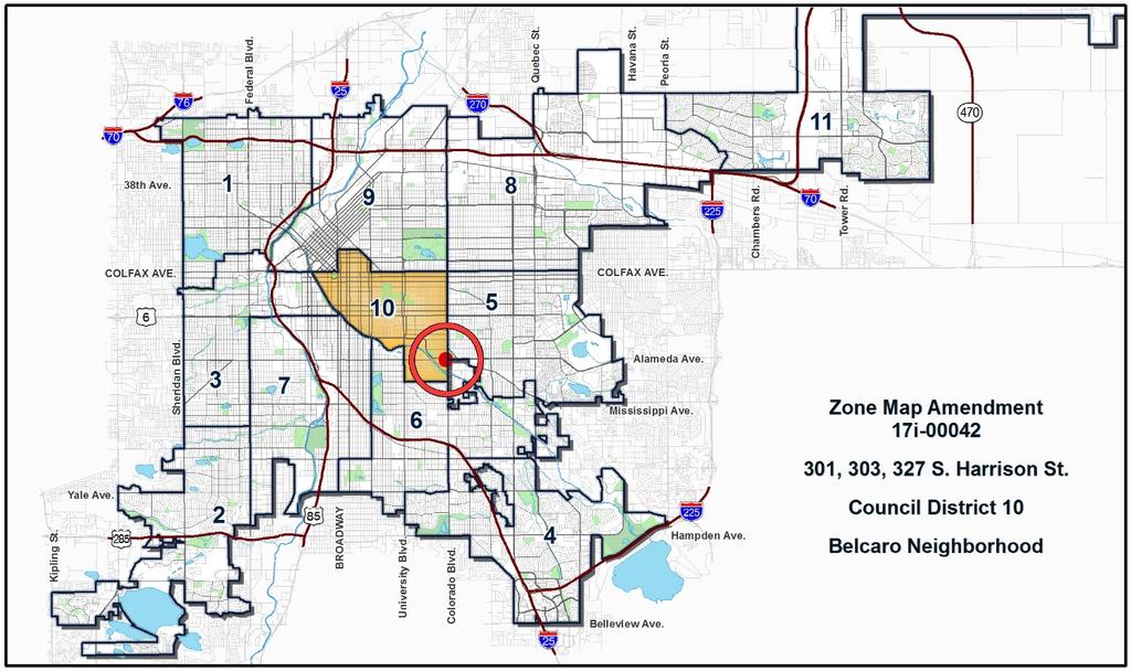
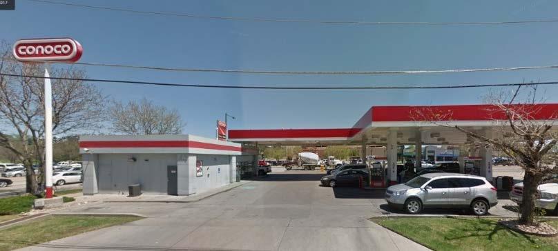
1 TO: Denver Planning Board, Julie Underdahl, Chair FROM: Theresa Lucero, Senior City Planner DATE: RE: Official Zoning Map Amendment Application #2017I Staff Report and Recommendation Based on the criteria for review in the Denver Zoning Code, staff recommends approval for map amendment application #2017I Request for Rezoning Address: Neighborhood/Council District: Belcaro Neighborhood / City Council District 10 RNOs: Cherry Creek East Association; Cranmer Park Hilltop Civic Association; Denver Neighborhood Association, Inc.; Inter- Neighborhood Cooperation Area of Property: 31,846 SF, 0.73 acres Current Zoning: B-4 with Waivers, UO-1 & UO-2 Proposed Zoning: C-MX-5 and C-MX-8 Property Owner(s): Joseph H. McSoud and Shea NWM, LLC Owner Representative: Mark Johnson, Opus Development Company LLC Summary of Rezoning Request The subject property consists of two parcels, the larger parcel contains a car wash built in 1985, and the smaller parcel is vacant. The existing zoning is a Former Chapter 59 zone district, B-4 with waivers, approved in The property owners propose to rezone the subject property for future redevelopment. The C-MX-5 zone district is proposed for 33 feet of the property closest to East Alameda Avenue, and the C-MX-8 zone district is proposed for the remainder of the property. The C-MX-5 and 8 (Urban Center, Mixed Use, with 5- and 8-story height limits) zone districts are intended for use in the Urban Center Neighborhood Context. This context consists of multiunit residential and mixed-use commercial strips and commercial centers. Multi-unit residential uses are typically in multi-story mixed-use building forms, and commercial buildings are typically Shopfront and General building forms. Multi-unit residential uses are primarily located along residential collector, mixed use arterial and local streets. Commercial uses are primarily located along main and mixed-use arterial streets. Block patterns are shaped by a grid street system. The mixed-use zone districts encourage safe, active and pedestrian-scaled diverse areas that ensure new development contribute positively to established neighborhoods. The C-MX-5 and 8 zone districts have maximum height limits of 70 feet and 110 feet, respectively. Further details of the zone districts can be found in Article 7 of the Denver Zoning Code (DZC). Planning Services Community Planning and Development 201 W. Colfax Ave., Dept. 205 Denver, CO p
2 Page 2

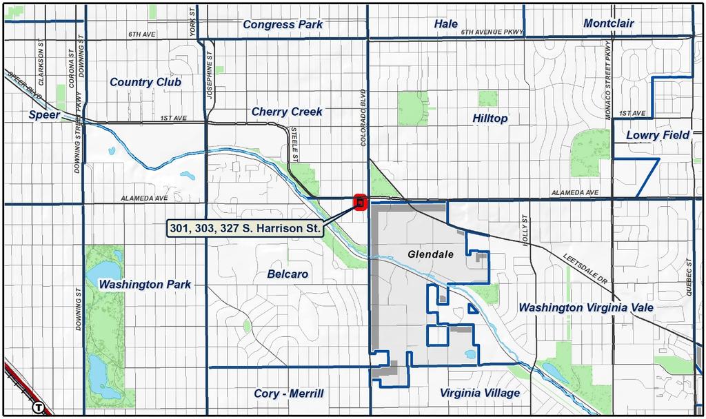
3 Page 3 Existing Context The subject property is in southeast Denver in the Belcaro Statistical Neighborhood. The property is in the northeast portion of the neighborhood, across East Alameda from the Cherry Creek East portion of the Cherry Creek neighborhood. The property is one property removed from South Colorado Boulevard to the east, 4 blocks south of 1 st Avenue, and 15 blocks east University Boulevard. The Cherry Creek Shopping Center is 7 blocks to the northwest, and the City of Glendale is ½ block east across South Colorado Boulevard. Area parks include Pulaski and City of Karmiel Park between Bayaud and Alameda Avenues along Cherry Creek North Drive, the Cherry Creek Greenway and Trail aligned along Cherry Creek, and across Colorado Boulevard, Burns and Cranmer Parks. Area schools include Bromwell Elementary School located at 3 rd and Josephine Street, Good Shepherd Catholic
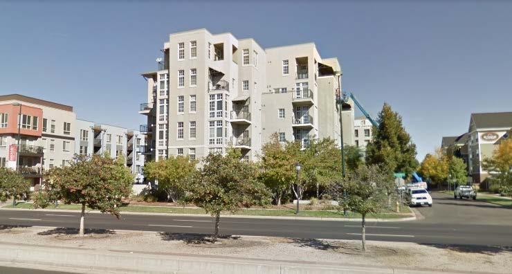
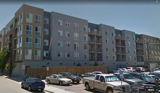
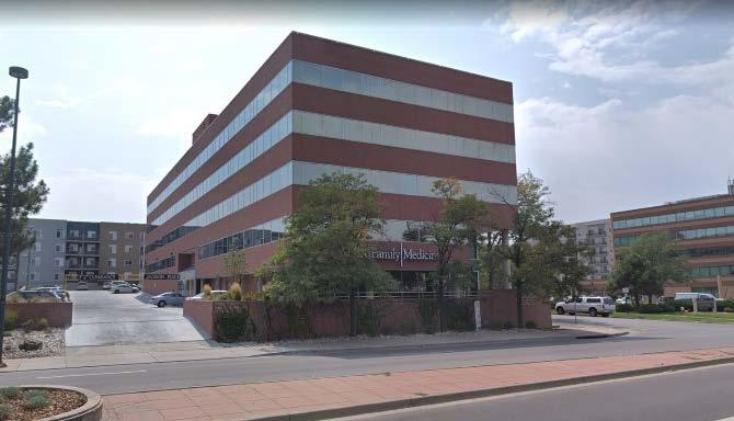
4 Page 4 Church at 6 th and Elizabeth, Hill Middle School a 5 th and Clermont Street and Graland Country Day School at 1 st and Clermont Street. The physical context of the neighborhood is a traditional street grid with rectilinear blocks and some alleys. Sidewalks are a mixture of detached with landscaping and attached. The following table summarizes the existing context adjacent to the subject site: Site Existing Zoning B-4 with waivers, UO- 1 and UO-2 Existing Land Use Commercial North G-MU-5 Multi-unit Residential South East West B-4 with waivers, UO- 1 and UO-2 E-MX-3, UO- 1 and UO-2 B-4 with waivers, UO- 1 and UO-2 Multi-unit Residential Commercial/Retail Office Existing Building Form/Scale 1-story commercial structure 6-story residential structure 5-story residential 1-story commercial structure 5-story commercial structures Existing Block, Lot, Street Pattern Regular grid streets shaping a consistent pattern of rectilinear blocks with some alleys; Vehicle parking is both structured and to the side or rear of buildings (alley access where alleys are present).

5 Page 5 1. Existing Zoning The existing zoning of B-4 with waivers is a Former Chapter 59 zone district approved in The B-4 district is a general business district encouraged along arterial streets. The district allows a wide variety of land uses and limits the maximum building floor area of structures to two times the site area. The approved waivers prohibit a variety of commercial uses, including adult uses, and industrial land uses, and waive the allowed height to a maximum of 72 feet. 2. View Plane The subject property is within the Cranmer Park view plane which restricts building heights to preserve mountain views. The allowable building height on the property is approximately 132 feet.

6 Page 6 3. Existing Land Use Map


7 Page 7 4. Existing Building Form and Scale
8 Page 8 Summary of City Agency Referral Comments As part of the DZC review process, the rezoning application is referred to potentially affected city agencies and departments for comment. A summary of agency referral responses follows: Asset Management: Approved No Comments. Environmental Health: Approved with the following comments: Notes. The Denver Department of Environmental Health (DEH) concurs with the rezoning request. However, DEH has information to indicate that a past petroleum release occurred from an underground tank system at a nearby property and a dry-cleaning facility may have also been historically present. Additionally, the property has operated as an automotive service station and nearby properties have operated as gas stations. Based on historical uses at the property and nearby properties, potential environmental conditions may exist that could impact redevelopment of the site. The developer should have assurance that site conditions are protective of workers during construction activities and of residents and workers during proposed use operations. If not already completed, the applicant may consider completing environmental site assessments to help determine the presence, nature and extent of potential contamination at the property and to identify specific cleanup needs. If encountered during construction, underground storage tanks and contaminated soil and groundwater should be managed and disposed of in accordance with applicable regulations. Several groundwater monitoring wells are or were located at the property, potentially in relation to monitoring of current or past chemical impacts to groundwater. If present, monitoring wells should be properly abandoned in accordance with Colorado Division of Water Resources rules. General Notes: Most of Colorado is high risk for radon, a naturally occurring radioactive gas. Due to concern for potential radon gas intrusion into buildings, DEH suggests installation of a radon mitigation system in structures planned for human occupation or frequent use. It may be more cost effective to install a radon system during new construction rather than after construction is complete. Denver s Noise Ordinance (Chapter 36 Noise Control, Denver Revised Municipal Code) identifies allowable levels of noise. Properties undergoing Re-Zoning may change the acoustic environment, but must maintain compliance with the Noise Ordinance. Compliance with the Noise Ordinance is based on the status of the receptor property (for example, adjacent Residential receptors), and not the status of the noise-generating property. Violations of the Noise Ordinance commonly result from, but are not limited to, the operation or improper placement of HV/AC units, generators, and loading docks. Construction noise is exempted from the Noise Ordinance during the following hours, 7am 9pm (Mon Fri) and 8am 5pm (Sat & Sun). Variances for nighttime work are allowed, but the variance approval process requires 2 to 3 months. For variance requests or questions related to the Noise Ordinance, please contact Paul Riedesel, Denver Environmental Health ( ). Scope & Limitations: DEH performed a limited search for information known to DEH regarding environmental conditions at the subject site. This review was not intended to conform to ASTM standard practice for Phase I site assessments, nor was it designed to identify all potential environmental conditions. In addition, the review was not intended to assess environmental conditions for any potential right-of-way or easement conveyance process. The City and County of Denver provides no representations or warranties regarding the accuracy, reliability, or completeness of the information provided.
9 Page 9 Parks and Recreation: Approved with the following comment. Parks would approve of the zoning change conditioned on a full 20-foot parkway setback along East Alameda Parkway from the existing (current) property boundary. Public Works City Surveyor: Approved. Public Works Wastewater: Approved with the following comments. DES Wastewater approves the subject zoning change. The applicant should note that redevelopment of this site may require additional engineering including preparation of drainage reports, construction documents, and erosion control plans. Redevelopment may require construction of water quality and detention basins, public and private sanitary and storm sewer mains, and other storm or sanitary sewer improvements. Redevelopment may also require other items such as conveyance of utility, construction, and maintenance easements. The extent of the required design, improvements and easements will be determined during the redevelopment process. Please note that no commitment for any new sewer service will be given prior to issuance of an approved SUDP from Development Services.
10 Page 10 Public Review Process CPD informational notice of receipt of the rezoning application to all affected members of City Council and Registered Neighborhood Organizations: Property legally posted for a period of 15 days and CPD written notice of the Planning Board public hearing sent to all affected members of City Council and Registered Neighborhood Organizations: Date 10/20/17 01/22/18 Planning Board public hearing: 02/07/18 CPD written notice of the Land Use, Transportation and Infrastructure Committee meeting sent to all affected members of City Council and Registered Neighborhood Organizations, at least ten working days before the meeting: Land Use, Transportation and Infrastructure Committee of the City Council: 02/12/18 02/27/18 Property legally posted for a period of 21 days and CPD written notice of the City Council public hearing sent to all affected 03/17/18 members of City Council and Registered Neighborhood Organizations: City Council Public Hearing: 04/09/18 Registered Neighborhood Organizations (RNOs) To date, CPD has received no comment letters from any Registered Neighborhood Organization. Other Public Comment To date, no other public comments have been received.
11 Page 11 Criteria for Review / Staff Evaluation The criteria for review of this rezoning application are found in DZC, Sections and , as follows: DZC Section Consistency with Adopted Plans 2. Uniformity of District Regulations and Restrictions 3. Public Health, Safety and General Welfare DZC Section Justifying Circumstances 2. Consistency with Neighborhood Context Description, Zone District Purpose and Intent Statements 1. Consistency with Adopted Plans The following adopted plans apply to this property: Denver Comprehensive Plan 2000 Blueprint Denver (2002) Cherry Creek Area Plan (2012) Denver Comprehensive Plan 2000 The proposal is consistent with many Denver Comprehensive Plan strategies, including: Environmental Sustainability Strategy 2-F Conserve land by promoting infill development within Denver at sites where services and infrastructure are already in place (p. 39). Land Use Strategy 3-B Encourage quality infill development that is consistent with the character of the surrounding neighborhood; that offers opportunities for increased density and more amenities; and that broadens the variety of compatible uses (p. 60). Mobility Strategy 4-E Continue to promote mixed-use development, which enables people to live near, work, retail and services (p. 78). Legacies Strategy 3-A Identify areas where increased density and new uses are desirable and can be accommodated (p. 99). Economic Activity Strategy 4-B Enhance existing business centers and establish new business centers in a manner that offers a variety of high-quality uses that support Denver s business environment, complements neighboring residential areas, generates public revenue, and creates jobs (p. 135). The rezoning is consistent with these Plan recommendations. The proposed C-MX-5 and 8 zone districts allow a variety of residential and commercial land uses. The map amendment will enable the redevelopment of the property in a manner that increases density, is consistent with the existing character of the area and is in a location where infrastructure is already in place. Blueprint Denver According to the Plan Map adopted in Blueprint Denver, this site has a concept land use of Regional Center and is in an Area of Change.

12 Page 12 Future Land Use The Blueprint Denver Regional Center concept land use designation is described in the Plan as having a balance of retail, employment and residential land uses, though some may have begun as one major use like a regional shopping center or a large office park. These centers generally cover a large area and are dense enough to encompass both the dominant use and a wide variety of other uses. Cherry Creek is an example of a regional center where a major shopping center is at the core of many other uses concentrated in a small area (p. 43). Blueprint Denver Future Land Use Map Area of Change / Area of Stability As noted, the subject property is in an Area of Change. In general, The goal for Areas of Change is to channel growth where it will be beneficial and can best improve access to jobs, housing and services with fewer and shorter auto trips...a major goal is to increase economic activity in the area to benefit existing residents and businesses, and where necessary, provide a stimulus to redevelop (p. 127).
13 Page 13 The rezoning application is consistent with the Blueprint Denver Area of Change recommendation of channeling growth where it can improve access to housing and services with fewer and shorter auto trips. Expanding and redeveloping residential and commercial land uses near the shopping and services of the Cherry Creek Shopping Center and Cherry Creek East Area make this proposal consistent with the goals of Areas of Change. Street Classifications Blueprint Denver classifies East Alameda Avenue as a Mixed Use Arterial Street and Harrison Street as Undesignated Local Street. According to Blueprint Denver, Mixed Use Arterial streets provide a high degree of mobility as their primary function, and connect major urban elements such as the central business district, employment centers, large urban and suburban commercial centers and residential neighborhoods (p. 51). Mixed Use streets are located in high-intensity mixed-use commercial, retail and residential areas with substantial pedestrian activity (p. 57). Local streets are tailored more to providing local access. Blueprint Denver also classifies East Alameda Avenue and South Colorado Boulevard, ½ block to the east, as Enhanced Transit Corridors. On these corridors, the Plan encourages evaluating and implementing enhanced bus transit service (p. 98), and developing transitsupportive incentives like shared or reduced parking, and a mix of transit-supportive land uses (p. 100). The number 40 bus on Colorado Boulevard ½ block to the east arrives every 15 minutes. The proposed C-MX-5 and 8 zone districts allow the higher-intensity mixture of uses envisioned for areas served by mixed-use arterial streets and high-frequency transit services in a Regional Center/Area of Change. Former Chapter 59 Zoning with Waivers Blueprint Denver recommends rezoning Former Chapter 59 zoning with waivers to Denver Zoning Code zone districts. Regarding waivers and conditions, Blueprint Denver provides the following guidance on page 82: The unsatisfactory performance of the current regulations has led to the use of unique conditions and waivers applied to rezonings. These waivers and conditions, which are not organized in the zoning code, further complicate Denver s zoning situation. In addition, these conditions are written to address the construction of buildings and are not crafted broadly enough to address the ongoing regulation of the land after construction is completed. They remain enforceable for decades after, regardless of their effectiveness and applicability. The result is that the regulatory system does not deliver effective land-use regulation, but its administration absorbs a large amount of resources. It is difficult to envision how Blueprint Denver will be implemented by simply adding another layer of regulation on top of the current code. In fact, if the reforms mentioned in this chapter are instituted, it may be appropriate to eliminate the practice of rezoning with conditions and waivers. Rezoning to a standard zone district in the Denver Zoning Code will implement the cited Blueprint Denver plan guidance by eliminating the limiting zoning waivers from this site.

14 Page 14 Cherry Creek Area Plan (2012) The Cherry Creek Area Plan offers guidance for both the overall neighborhood, in the Framework Plan, and for subareas within the neighborhood. The Plan includes the area south of Alameda Avenue, though officially the area is within the Belcaro statistical neighborhood. The Framework portion of the Plan discusses the mixed-use character of the Cherry Creek Neighborhood. Part of the character of Cherry Creek is its mixture of land uses. Retail and service uses appealing to both local and regional shoppers, office and established residential neighborhoods weave an interdependent mixed-use urban environment resulting in a variety of amenities benefiting the quality of life. [ ] Continued introduction of office space, retail, and residential units will enhance the mixed-use nature of the neighborhood and reinforce the plan vision. As in most mixed-use districts throughout the country, the desire to maintain the character of Cherry Creek must be balanced with the thoughtful redevelopment of underutilized properties (pg ).

15 Page 15 Framework Plan The Framework Plan also updated the Blueprint Denver Map of Areas of Change and offers this guidance for Areas of Change: The Areas of Change in Cherry Creek have the greatest potential to accommodate this growth, both in terms of market demand and available land. Although not every property will see significant redevelopment, overall these areas benefit from new development, reinvestment, and more intense use. Areas of Change include the Shopping District, Cherry Creek Triangle, 1st Avenue, the commercial node at Madison and Bayaud and Harrison Street south of 1st Avenue (pg. 29). And further, the Plan provides the following recommendations for targeting growth in these Cherry Creek Areas of Change: Acknowledge that to remain prosperous, Cherry Creek must continue to grow and change. In order for this growth to occur in a way that reinforces the quality of life for Cherry Creek residents, the bulk of this growth should occur in these areas rather than stable neighborhoods (p. 29). Update the Blueprint Denver map to reflect revised Areas of Change boundaries. The updated Areas of Change are targeted to receive most of Cherry Creek s residential and commercial growth over the next twenty years (p. 29). Modify land use policy, zoning regulations and design guidelines to encourage appropriate reinvestment to assure that Areas of Change continue to mature in positive ways (p. 29). The subject property is circled on the Blueprint Denver Map and the updated Cherry Creek Areas of Change map below.

16 Page 16 Further, the Plan recommends utilizing urban design strategies to create appropriate transitions inbuilding heights and uses Several key areas exist in Cherry Creek where areas of change sit adjacent to areas of stability. In these cases, new development should provide appropriate transitions in scale. Key transition areas include Across Alameda Parkway between Cherry Creek East and Cherry Creek Triangle (p. 32). Finally, the Framework Plan recommends promoting continued investment and development in emerging neighborhoods. The Cherry Creek Triangle is an emerging neighborhood providing a direct link between Cherry Creek and Glendale along the Cherry Creek Greenway. Development in this neighborhood has recently featured two multi-story residential structures to complement the existing mixture of office, hotel and retail uses within the area Continued development should focus on quality architecture, improved streetscapes and enhancing the connections to Cherry Creek East and the Cherry Creek Greenway (p.35). The proposed C- MX-5 and 8 zone districts implement the Cherry Creek Area Plan concepts of accommodating higher-intensity mixed use growth in an area of change, creating an appropriate transition in height between the Cherry Creek Triangle and Cherry Creek East and supporting development in an emerging portion of the neighborhood. Cherry Creek Subareas The Cherry Creek Area Plan also contains recommendations for subareas defined by the Plan. Subarea recommendations are used in the Plan to supplement the more general Framework Plan recommendations. The subject property is in the Cherry Creek Triangle subarea (see the circled area on the subarea map). This subarea is described by the Plan as supporting a wide range of land uses including large and small office buildings, multi-family residential structures and small-scale commercial serving Colorado Boulevard. For this subarea the Plan recommends: Cherry Creek Triangle remains an Area of Change, meaning growth and reinvestment should be encouraged. Its prime location, existing mixture of uses, economic development opportunities and access to transit service create an ideal location for encouraging residential, commercial and employment growth. New development should continue to include a mix of land uses, especially office and residential. These uses should continue to be integrated into the neighborhood and serve residents, employees and visitors. Commercial uses on Colorado Boulevard should be better integrated into the fabric of Cherry Creek Triangle.

17 Page 17 New development within the Triangle should respond to the surrounding conditions of parkways, greenways and other development. Special attention should be placed on the greenway edge of the Triangle to enhance visibility and connectivity to this important amenity. Street facing entries and ground floor transparency will be key elements for activating the pedestrian realm. Appropriate building mass transitions are important adjacent to Cherry Creek East to integrate development and reinvestment into the area. Maximum building heights will range from 5 to 12 stories, with a 5-story edge along Alameda to respond to lower scale residential on the north side of the street. This transition may be accomplished through variations in building height, upper story setbacks or other mass and scale alternatives (p ). The proposed 5 and 8-story heights conforms to the maximum building height recommended in the Cherry Creek Area Plan for the subarea. The proposed mixed-use districts would enable a mix of land uses and the proposed districts provide an appropriate height transition to the Cherry Creek East subarea across Alameda Avenue. See the Plan s Future Land Use Map and the Maximum Building Heights Map below.
18 Page Uniformity of District Regulations and Restrictions The proposed rezoning to C-MX-5 and 8 zone districts will result in the uniform application of zone district building form, use and design regulations. 3. Public Health, Safety and General Welfare The proposed official map amendment furthers the public health, safety, and general welfare of the City by implementing the City s adopted plans for the area, and by readying the property for reinvestment with zone districts that provide adequate transitions to the surrounding area and improve the pedestrian environment through improved building form standards. 4. Justifying Circumstance The application identifies changed or changing conditions as the Justifying Circumstance under DZC Section A.4, The land or its surrounding environs has changed or is changing to such a degree that it is in the public interest to encourage a redevelopment of the area or to recognize the changed character of the area. As the Cherry Creek Area Plan discusses above, Cherry Creek must continue to grow and change to remain prosperous and to reinforce the quality of life for neighborhood residents. The subject property is located within an area the Cherry Creek Area Plan designates as a Regional Center and an Area of Change, where reinvestment and growth should be directed, and where the character of the area is expected to change, and is indeed changing. Several recent multi-unit and mixed-use development have been built in the surrounding area. The proposed rezoning will acknowledge the changing character of the area and will accommodate the planned reinvestment in the area, and this is an appropriate justifying circumstance for the proposed rezoning. 5. Consistency with Neighborhood Context Description, Zone District Purpose and Intent Statements The requested C-MX-5 and 8 zone districts are within the Urban Center Neighborhood Context. The Urban Center Context is characterized by multi-unit residential and mixed use commercial strips and centers in a variety of building forms. Multi-unit residential uses are primarily located along residential collector, mixed-use arterial and local streets. Commercial uses are primarily located along main and mixed-use arterials. The block and street pattern consist of regular block shapes formed by a grid street system. In this context building heights are moderate to high to promote a dense urban character. A high level of connectivity to multi-modal transit is characteristic of the context. The C-MX-5 and 8 zone districts are intended to promote safe, active, and pedestrian-scaled diverse areas with a variety of residential and commercial building forms located on collector or arterial streets. The proposed rezoning of the subject property to C-MX-5 and 8 zone districts is consistent with the Urban Center Context and the specific intent of the C-MX-5 and 8 zone districts. Attachments 1. Application 2. Approved Legal Description 3. Existing B-4 waivers
19 Zone Map Amendment (Rezoning) - Application COMMUNITY PLANNING & DEVELOPMENT REZONING GUIDE Rezoning Application Page 1 of 3 PROPERTY OWNER INFORMATION* CHECK IF POINT OF CONTACT FOR APPLICATION Property Owner Name Address City, State, Zip Telephone PROPERTY OWNER(S) REPRESENTATIVE** CHECK IF POINT OF CONTACT FOR APPLICATION Representative Name Address City, State, Zip Telephone *If More Than One Property Owner: All standard zone map amendment applications shall be initiated by all the owners of at least 51% of the total area of the zone lots subject to the rezoning application, or their representatives authorized in writing to do so. See page 3. **Property owner shall provide a written letter authorizing the representative to act on his/her behalf. Please attach Proof of Ownership acceptable to the Manager for each property owner signing the application, such as (a) Assessor s Record, (b) Warranty deed or deed of trust, or (c) Title policy or commitment dated no earlier than 60 days prior to application date. If the owner is a corporate entity, proof of authorization for an individual to sign on behalf of the organization is required. This can include board resolutions authorizing the signer, bylaws, a Statement of Authority, or other legal documents as approved by the City Attorney s Office. SUBJECT PROPERTY INFORMATION Location (address and/or boundary description): Assessor s Parcel Numbers: Area in Acres or Square Feet: Current Zone District(s): PROPOSAL Proposed Zone District: Last updated: February 22, 2017 Return completed form to rezoning@denvergov.org 201 W. Colfax Ave., Dept. 205 Denver, CO rezoning@denvergov.org

20 COMMUNITY PLANNING & DEVELOPMENT REZONING GUIDE Rezoning Application Page 2 of 3 REVIEW CRITERIA General Review Criteria: The proposal must comply with all of the general review criteria DZC Sec Additional Review Criteria for Non-Legislative Rezonings: The proposal must comply with both of the additional review criteria DZC Sec Consistency with Adopted Plans: The proposed official map amendment is consistent with the City s adopted plans, or the proposed rezoning is necessary to provide land for a community need that was not anticipated at the time of adoption of the City s Plan. Please provide an attachment describing relevant adopted plans and how proposed map amendment is consistent with those plan recommendations; or, describe how the map amendment is necessary to provide for an unanticipated community need. Uniformity of District Regulations and Restrictions: The proposed official map amendment results in regulations and restrictions that are uniform for each kind of building throughout each district having the same classification and bearing the same symbol or designation on the official map, but the regulations in one district may differ from those in other districts. Public Health, Safety and General Welfare: The proposed official map amendment furthers the public health, safety, and general welfare of the City. Justifying Circumstances - One of the following circumstances exists: The existing zoning of the land was the result of an error. The existing zoning of the land was based on a mistake of fact. The existing zoning of the land failed to take into account the constraints on development created by the natural characteristics of the land, including, but not limited to, steep slopes, floodplain, unstable soils, and inadequate drainage. The land or its surroundings has changed or is changing to such a degree that it is in the public interest to encourage a redevelopment of the area to recognize the changed character of the area. It is in the public interest to encourage a departure from the existing zoning through application of supplemental zoning regulations that are consistent with the intent and purpose of, and meet the specific criteria stated in, Article 9, Division 9.4 (Overlay Zone Districts), of this Code. Please provide an attachment describing the justifying circumstance. The proposed official map amendment is consistent with the description of the applicable neighborhood context, and with the stated purpose and intent of the proposed Zone District. Please provide an attachment describing how the above criterion is met. REQUIRED ATTACHMENTS Please ensure the following required attachments are submitted with this application: Legal Description (required to be attached in Microsoft Word document format) Proof of Ownership Document(s) (Assessor Records) Review Criteria (See attached narrative) ADDITIONAL ATTACHMENTS Please identify any additional attachments provided with this application: Written Authorization to Represent Property Owner(s) Individual Authorization to Sign on Behalf of a Corporate Entity Please list any additional attachments: Last updated: February 22, 2017 Return completed form to rezoning@denvergov.org 201 W. Colfax Ave., Dept. 205 Denver, CO rezoning@denvergov.org
21
22 EXHIBIT A C-MX-5 AREA SHEET 1 OF 2 A PORTION OF LAND WITHIN LOTS 9 AND 10, BLOCK 47 OF BURLINGTON CAPITAL HILL ADDITION, RECORDED AT BOOK 5, PAGE 14, TOGETHER WITH A PORTION OF VACATED S. HARRISON STREET PER AMENDED ORDIANCE 0046 SERIES 1988, LOCATED WITHIN THE SOUTHEAST QUARTER OF SECTION 12, TOWNSHIP 4 SOUTH, RANGE 68 WEST OF THE SIXTH PRINCIPAL MERIDIAN, CITY AND COUNTY OF DENVER, STATE OF COLORADO, BEING MORE PARTICULARLY DESCRIBED AS FOLLOWS: COMMENCING AT THE NORTHEAST QUARTER CORNER SECTION 13, TOWNSHIP 4 SOUTH, RANGE 68 WEST OF THE 6TH PRINCIPAL MERIDIAN; THENCE ALONG THE NORTHEAST LINE OF SAID SECTION 13, S W A DISTANCE OF FEET; THENCE N W A DISTANCE OF FEET TO THE EASTERLY LINE OF SAID S. HARRISON STREET RIGHT-OF-WAY VACATION BEING THE POINT OF BEGINNING; THENCE S W A DISTANCE OF FEET TO A POINT ON THE WESTERLY LINE OF SAID LOT 9; THENCE ALONG THE WESTERLY LINE OF SAID LOTS 9 AND 10, N W A DISTANCE OF FEET; THENCE N E A DISTANCE OF FEET TO THE EASTERLY LINE OF SAID S. HARRISON STREET RIGHT-OF-WAY VACATION; THENCE ALONG SAID EASTERLY LINE S E A DISTANCE OF FEET TO THE POINT OF BEGINNING: SAID PARCEL CONTAINS ACRES (4,443 SQUARE FEET), MORE OR LESS. ALL DIMENSIONS ARE IN U.S. SURVEY FEET. BASIS OF BEARING: BEARINGS ARE BASED ON THE NORTH LINE OF THE NORTHEAST QUARTER OF SECTION 13, TOWNSHIP 4 SOUTH, RANGE 68 WEST OF THE 6TH PRINCIPAL MERIDIAN, BEING ASSUMED TO BEAR NORTH 89 39'22" EAST AND MONUMENTED AS SHOWN HEREON. PREPARED BY DENNIS PETER REVIEWED BY RICHARD A. NOBBE, PLS FOR AND ON BEHALF OF MARTIN/MARTIN, INC WEST COLFAX AVENUE LAKEWOOD, COLORADO OCTOBER 16, 2017
23 EXHIBIT B C-MX-8 AREA SHEET 1 OF 2 A PORTION OF LAND WITHIN LOTS 6 THRU 9, BLOCK 47 OF BURLINGTON CAPITAL HILL ADDITION, RECORDED AT BOOK 5, PAGE 14, AND WITHIN LOTS 46 THRU 50, BLOCK 2 OF BURNSDALE SUBDIVISION, RECORDED AT BOOK 18, PAGE 45, TOGETHER WITH A PORTION OF VACATED S. HARRISON STREET PER AMENDED ORDIANCE 0046 SERIES 1988, LOCATED WITHIN THE SOUTHEAST QUARTER OF SECTION 12 AND THE NORTHEAST QUARTER OF SECTION 13, TOWNSHIP 4 SOUTH, RANGE 68 WEST OF THE SIXTH PRINCIPAL MERIDIAN, CITY AND COUNTY OF DENVER, STATE OF COLORADO, BEING MORE PARTICULARLY DESCRIBED AS FOLLOWS: COMMENCING AT THE NORTHEAST QUARTER CORNER SECTION 13, TOWNSHIP 4 SOUTH, RANGE 68 WEST OF THE 6TH PRINCIPAL MERIDIAN; THENCE ALONG THE NORTHEAST LINE OF SAID SECTION 13, S W A DISTANCE OF FEET TO THE EASTERLY LINE OF SAID S. HARRISON STREET RIGHT-OF-WAY VACATION BEING THE POINT OF BEGINNING; THENCE ALONG SAID EASTERLY LINE, S E A DISTANCE OF FEET; THENCE ALONG THE SOUTHERLY LINE OF SAID LOT 46 EXTENDED, S W A DISTANCE OF FEET TO THE SOUTHWEST CORNER OF SAID LOT 46; THENCE ALONG THE WESTERLY LINE OF SAID LOTS 46-50, N W A DISTANCE OF FEET; THENCE ALONG THE WESTERLY LINE OF SAID LOTS 6-9, N W A DISTANCE OF FEET; THENCE N E A DISTANCE OF FEET TO SAID EASTERLY LINE OF S. HARRISON STREET RIGHT-OF-WAY VACATION; THENCE ALONG SAID EASTERLY LINE, S E A DISTANCE OF FEET TO THE POINT OF BEGINNING: SAID PARCEL CONTAINS ACRES (27,471 SQUARE FEET), MORE OR LESS. ALL DIMENSIONS ARE IN U.S. SURVEY FEET. BASIS OF BEARING: BEARINGS ARE BASED ON THE NORTH LINE OF THE NORTHEAST QUARTER OF SECTION 13, TOWNSHIP 4 SOUTH, RANGE 68 WEST OF THE 6TH PRINCIPAL MERIDIAN, BEING ASSUMED TO BEAR NORTH 89 39'22" EAST AND MONUMENTED AS SHOWN HEREON. PREPARED BY DENNIS PETER REVIEWED BY RICHARD A. NOBBE, PLS FOR AND ON BEHALF OF MARTIN/MARTIN, INC WEST COLFAX AVENUE LAKEWOOD, COLORADO OCTOBER 16, 2017
24
25
26
Staff Report and Recommendation
 Community Planning and Development Planning Services 201 W. Colfax Ave., Dept. 205 Denver, CO 80202 p: 720.865.2915 f: 720.865.3052 www.denvergov.org/cpd TO: City Council Neighborhoods and Planning Committee
2 nd & St Paul, LLC and BAH-PLA, LLC
 Community Planning and Development Planning Services 201 W. Colfax Ave., Dept. 205 Denver, CO 80202 p: 720.865.2915 f: 720.865.3052 www.denvergov.org/cpd TO: Denver City Council FROM: Theresa Lucero, Senior
Staff Report and Recommendation Based on the criteria for review in the Denver Zoning Code, Staff recommends approval for Application #2017I
 TO: Denver City Council Land Use, Transportation and Infrastructure Committee FROM: Theresa Lucero, Senior City Planner DATE: RE: Official Zoning Map Amendment Application #2017I-00149 Staff Report and
REZONING GUIDE. Zone Map Amendment (Rezoning) - Application. Rezoning Application Page 1 of 3. Return completed form to
 - Application. Rezoning Application Page 1 of 3. Return completed form to") Zone Map Amendment (Rezoning) - Application COMMUNITY PLANNING & DEVELOPMENT REZONING GUIDE Rezoning Application Page 1 of 3 PROPERTY OWNER INFORMATION* CHECK IF POINT OF CONTACT FOR APPLICATION Property
Zone Map Amendment (Rezoning) - Application COMMUNITY PLANNING & DEVELOPMENT REZONING GUIDE Rezoning Application Page 1 of 3 PROPERTY OWNER INFORMATION* CHECK IF POINT OF CONTACT FOR APPLICATION Property
Official Zoning Map Amendment Application #2018I-00047
 Community Planning and Development Planning Services 201 W. Colfax Ave., Dept. 205 Denver, CO 80202 p: 720.865.2915 f: 720.865.3052 www.denvergov.org/cpd TO: Denver Planning Board FROM: Chandler Van Schaack,
Staff Report and Recommendation Based on the criteria for review in the Denver Zoning Code, Staff recommends approval for Application #2018I
 Community Planning and Development Planning Services 201 W. Colfax Ave., Dept. 205 Denver, CO 80202 p: 720.865.2915 f: 720.865.3052 www.denvergov.org/cpd TO: Denver Planning Board FROM: Sara White, AICP,
Official Zoning Map Amendment Application #2018I-00077
 Community Planning and Development Planning Services 201 W. Colfax Ave., Dept. 205 Denver, CO 80202 p: 720.865.2915 f: 720.865.3052 www.denvergov.org/cpd TO: Denver Planning Board FROM: Scott Robinson,
Denver Land Use, Transportation and Infrastructure Committee FROM: Andrew Webb, Senior City Planner DATE: March 22, 2018 RE:
 Community Planning and Development Planning Services 201 W. Colfax Ave., Dept. 205 Denver, CO 80202 p: 720.865.2915 f: 720.865.3052 www.denvergov.org/cpd TO: Denver Land Use, Transportation and Infrastructure
REZONING GUIDE. Zone Map Amendment (Rezoning) - Application. Rezoning Application Page 1 of 3. Return completed form to
 - Application. Rezoning Application Page 1 of 3. Return completed form to") Zone Map Amendment (Rezoning) - Application COMMUNITY PLANNING & DEVELOPMENT REZONING GUIDE Rezoning Application Page 1 of 3 PROPERTY OWNER INFORMATION* CHECK IF POINT OF CONTACT FOR APPLICATION Property
Zone Map Amendment (Rezoning) - Application COMMUNITY PLANNING & DEVELOPMENT REZONING GUIDE Rezoning Application Page 1 of 3 PROPERTY OWNER INFORMATION* CHECK IF POINT OF CONTACT FOR APPLICATION Property
, C-MS I June 3, 2016 $1500 pd chk #216918
 , C-MS-8 LOTS 21 THROUGH 40, INCLUSIVE, BLOCK 299 CLEMENTS ADDITION TO THE CITY OF DENVER SOUTHEAST QUARTER OF SECTION 34, TOWNSHIP 3 SOUTH, RANGE 68 WEST, SIXTH PRINCIPAL MERIDIAN, CITY
September 25th, 2018 $2000 fee pd CC
 2.7267 acres 2018I-00075 September 25th, 2018 $2000 fee pd CC Rezoning Review Criteria Analysis - Map Amendment Application Number: 2018I-00075 805 W. 38 th Avenue October 19, 2018 (amd.) September 17,
To: S-MX-8 AIO, S-MX-8A AIO, S-MX-12 AIO, C-MX-8 AIO, C-MX-12 AIO, and S-CC-5 AIO
 Community Planning and Development Planning Services 201 W. Colfax Ave., Dept. 205 Denver, CO 80202 p: 720.865.2915 f: 720.865.3052 www.denvergov.org/cpd TO: City Council Neighborhoods and Planning Committee
Official Zoning Map Amendment Application #2018I-00075
 Community Planning and Development Planning Services 201 W. Colfax Ave., Dept. 205 Denver, CO 80202 p: 720.865.2915 f: 720.865.3052 www.denvergov.org/cpd TO: Denver Planning Board FROM: Scott Robinson,
TO: Denver Planning Board FROM: Analiese Hock, Senior City Planner DATE: March 13, 2018 RE:
 Community Planning and Development Planning Services 201 W. Colfax Ave., Dept. 205 Denver, CO 80202 p: 720.865.2915 f: 720.865.3052 www.denvergov.org/cpd TO: Denver Planning Board FROM: Analiese Hock,
Staff Report and Recommendation
 Community Planning and Development Planning Services 201 W Colfax Ave, Dept 205 Denver, CO 80202 p: 720-865-2972 f: 720-865-3056 www.denvergov.org/planning TO: LUTI FROM: Steve Nalley, Senior City Planner
TO: Denver Planning Board FROM: Chandler Van Schaack, Senior City Planner DATE: March 27, 2019 RE:
 Community Planning and Development Planning Services W. Colfax Ave., Dept. Denver, CO 0 p:.. f:..0 www.denvergov.org/cpd TO: Denver Planning Board FROM: Chandler Van Schaack, Senior City Planner DATE:
Staff Report and Recommendation
 Community Planning and Development Planning Services 201 W. Colfax Ave., Dept. 205 Denver, CO 80202 p: 720.865.2915 f: 720.865.3052 www.denvergov.org/cpd TO: Denver City Council FROM: Steve Nalley, Neighborhood
#2017I E-RH-2.5 Highland Ventures Holdings, LLC and Irving Estates, LLC
 TO: Denver Planning Board - Joel Noble, Chair FROM: Theresa Lucero, Senior City Planner DATE: RE: Official Zoning Map Amendment Application #2017I-00178 1080 and 1090 King Street Rezoning from E-SU-D1x
DENVER DESIGN DISTRICT GDP
 DENVER DESIGN DISTRICT GDP Urban Design Standards and Guidelines November 17, 2008 Amended February 3, 2016 City and County of Denver CF Property Management, Inc. C/O Denver Design District - Starboard
TO: Staff Report and Recommendation
 Community Planning and Development Planning Services 201 W. Colfax Ave., Dept. 205 Denver, CO 80202 p: 720.865.2915 f: 720.865.3052 www.denvergov.org/cpd TO: City Council Neighborhoods and Planning Committee
CITY OF PUYALLUP. Background. Development Services
 CITY OF PUYALLUP Development Services 333 South Meridian Puyallup WA 98371 To: City Council From: Katie Baker, AICP, Planning Division Re: South Hill Neighborhood Plan Adoption Date: (Meeting date: February
Drexel, Barrell & Co.
 Drexel, Barrell & Co. June 18, 2018 Engineers/Surveyors Boulder Colorado Springs Greeley 3 South 7 th Street Colorado Springs, Colorado 80905-1501 719 260-0887 719 260-8352 Fax El Paso County Planning
Steering Committee Meeting
 Neighborhood Planning Initiative NPI EAST CENTRAL AREA PLAN Steering Committee Meeting November 9, 2017 6:00PM 8:00PM Tears McFarlane House East Central Area Plan Steering Committee Meeting 11/9/17 AGENDA
ARTICLE 6: Special and Planned Development Districts
 ARTICLE 6: Special and Planned Development Districts 6-10 Traditional Neighborhood Development (TND) District 6-10.10 Purpose and Intent The Traditional Neighborhood Development (TND) District provides
Drexel, Barrell & Co.
 Drexel, Barrell & Co. December 21, 2018 Engineers/Surveyors Boulder Colorado Springs Greeley 3 South 7 th Street Colorado Springs, Colorado 80905-1501 719 260-0887 719 260-8352 Fax El Paso County Planning
VIRGINIA DRIVE SPECIAL PLAN
 August 15, 2017 Staff Report to the Municipal Planning Board CASE #GMP2017-10006 & LDC2017-00231 Item # 7 VIRGINIA DRIVE SPECIAL PLAN Location Map Subject Site SUMMARY Applicant City of Orlando, Planning
LAND USE DESIGNATIONS AND ZONING CLASSIFICATIONS
 LAND USE DESIGNATIONS AND ZONING CLASSIFICATIONS One of the most significant issues addressed within the community plan process is land use. How land is utilized within a community directly affects the
NEW CASTLE COUNTY S ZONING DISTRICTS
 NEW CASTLE COUNTY S ZONING DISTRICTS This is general information about New Castle County s zoning districts. The information included is by no means exhaustive or complete. Before designing plans to develop
SECTION II SECTION II STATEMENT OF GOALS, OBJECTIVES, PRINCIPLES, ASSUMPTIONS, POLICIES AND STANDARDS
 STATEMENT OF GOALS, OBJECTIVES, PRINCIPLES, ASSUMPTIONS, POLICIES AND STANDARDS 1 2 STATEMENT OF GOALS, OBJECTIVES, PRINCIPLES, ASSUMPTIONS, POLICIES AND STANDARDS INTRODUCTION The New Jersey Municipal
Tyvola & Archdale Transit Station Area Plan. May 15, 2008
 Tyvola & Archdale Transit Station Area Plan First Public Meeting May 15, 2008 Presentation Outline 1. Purpose and Process 2. Station Area Overview 3. Plan Recommendations Vision Land Use Transportation
SPECIFIC PLAN Requirements
 CITY OF LANCASTER PLANNING DEPARTMENT 44933 Fern Avenue, Lancaster, California 93534 (661) 723-6100 SPECIFIC PLAN Requirements Purpose The purpose of a specific plan is to provide for the logical development
General Location Annex, Rezone & Preliminary Plat Lansdowne Addition, Unit Three
 NEWFOUNDLAND I-5 Agricultural District Subject Site SUNDANCE ANDERSON Single Family Residential CHRISTY PUD Agricultural District Highway Business General Location Annex, Rezone & Preliminary Plat Lansdowne
AWH REPORT OF THE PLANNING AND DEVELOPMENT DEPARTMENT FOR APPLICATION FOR REZONING ORDINANCE TO PLANNED UNIT DEVELOPMENT
 AWH REPORT OF THE PLANNING AND DEVELOPMENT DEPARTMENT FOR APPLICATION FOR REZONING ORDINANCE TO PLANNED UNIT DEVELOPMENT MAY 8, 2014 The Planning and Development Department hereby forwards to the Planning
LAND USE AMENDMENT DOWNTOWN COMMERCIAL CORE (WARD 7) MACLEOD TRAIL SE AND 5 AVENUE SE BYLAW 254D2017
 MACLEOD TRAIL SE AND 5 AVENUE SE BYLAW 254D2017") Page 1 of 10 EXECUTIVE SUMMARY This Land Use Amendment application seeks to redesignate a full downtown block (currently the YWCA site) from a Direct Control based on the CM-2 District (Land Use Bylaw
Page 1 of 10 EXECUTIVE SUMMARY This Land Use Amendment application seeks to redesignate a full downtown block (currently the YWCA site) from a Direct Control based on the CM-2 District (Land Use Bylaw
GDP BOUNDARY Christopher A. Brooks, PLS for and on behalf of Matrix Design Group, Inc. VICINITY MAP SCALE: N.T.S.
 COVER SHEET I, Christopher A. Brooks, a Registered Land Surveyor in the State of Colorado, do hereby certify that the description as shown on Sheet 2, for the Buckley Annex General Development Plan was
LAND USE AMENDMENT CORNERSTONE (WARD 3) 60 STREET NE AND COUNTRY HILLS BOULEVARD NE MAP 26NE BYLAW 22D2017
 60 STREET NE AND COUNTRY HILLS BOULEVARD NE MAP 26NE BYLAW 22D2017") Page 1 of 14 EXECUTIVE SUMMARY This Land Use Amendment application covers an area of 43.76 hectares ± (108.14 acres ±) located in northeast Calgary, bound by Country Hills Boulevard NE to the south and
Page 1 of 14 EXECUTIVE SUMMARY This Land Use Amendment application covers an area of 43.76 hectares ± (108.14 acres ±) located in northeast Calgary, bound by Country Hills Boulevard NE to the south and
Rapid City Planning Commission Rezoning Project Report
 Rapid City Planning Commission Rezoning Project Report July 21, 2016 Applicant Request(s) Case # 16RZ022 Rezoning from Office Commercial District to Light Industrial District Companion Case(s): 16RZ023-Rezoning
C. Westerly Creek Village & The Montview Corridor
 C. Westerly Creek Village & The VISION Community Vision When the goals of the city are achieved Westerly Creek Village, a distinctive community defined by Montview Boulevard and Westerly Creek, is a strong
Bloor St. W. Rezoning - Preliminary Report
 STAFF REPORT ACTION REQUIRED 1638-1644 Bloor St. W. Rezoning - Preliminary Report Date: April 1, 2008 To: From: Wards: Reference Number: Toronto and East York Community Council Acting Director, Community
PLANNED UNIT DEVELOPMENT & SUBDIVISION STAFF REPORT Date: May 18, 2017
 & PUD-0000102-2017 PLANNED UNIT DEVELOPMENT & SUBDIVISION STAFF REPORT Date: May 18, 2017 NAME SUBDIVISION NAME Dauphin Creek Estates Subdivision Dauphin Creek Estates Subdivision LOCATION CITY COUNCIL
ROAD CLOSURE AND LAND USE AMENDMENT SILVER SPRINGS (WARD 1) NORTHEAST OF NOSEHILL DRIVE NW AND SILVER SPRINGS ROAD NW BYLAWS 2C2018 AND 29D2018
 NORTHEAST OF NOSEHILL DRIVE NW AND SILVER SPRINGS ROAD NW BYLAWS 2C2018 AND 29D2018") Page 1 of 19 EXECUTIVE SUMMARY This application proposes redesignating two parcels in the community of Silver Springs from Special Purpose Future Urban Development (S-FUD) District and undesignated road
Page 1 of 19 EXECUTIVE SUMMARY This application proposes redesignating two parcels in the community of Silver Springs from Special Purpose Future Urban Development (S-FUD) District and undesignated road
Midtown Greenway Land Use and Development Plan Executive Summary
 Midtown Greenway Land Use and Development Plan Executive Summary Introduction The Midtown Greenway Land Use and Development Plan sets policy direction for land use and development in the Midtown Greenway
Welcome. Walk Around. Talk to Us. Write Down Your Comments
 Welcome This is an information meeting introducing the applications for proposed redevelopment of the Yorkdale Shopping Centre site at 3401 Dufferin Street and 1 Yorkdale Road over the next 20+ years,
PLANNED UNIT DEVELOPMENT Date: April 5, 2018
 PLANNED UNIT DEVELOPMENT Date: April 5, 2018 DEVELOPMENT NAME SUBDIVISION NAME LOCATION Robert Myers Robert Myers 2955 and 2989 Dauphin Street (Southeast corner of Dauphin Street and Sage Avenue) CITY
Land Use Amendment in Southwood (Ward 11) at and Elbow Drive SW, LOC
 at and Elbow Drive SW, LOC") 2018 November 15 Page 1 of 10 EXECUTIVE SUMMARY This land use amendment application was submitted by Rick Balbi Architect on 2017 August 31 on behalf of Sable Developments Ltd, and with authorization from
2018 November 15 Page 1 of 10 EXECUTIVE SUMMARY This land use amendment application was submitted by Rick Balbi Architect on 2017 August 31 on behalf of Sable Developments Ltd, and with authorization from
SECTION UNIFIED DEVELOPMENT ORDINANCE SECTION Part 1 Ordinance. ARTICLE 1 Zoning Districts
 SECTION 1-100 UNIFIED DEVELOPMENT ORDINANCE SECTION 1-300 Part 1 Ordinance SECTION 1-100. Introduction. ARTICLE 1 Zoning Districts Crystal Lake strives to maintain a balance of various land uses for a
Official Zoning Map Amendment Application #2018I-00131
 Community Planning and Development Planning Services 201 W. Colfax Ave., Dept. 205 Denver, CO 80202 p: 720.865.2915 f: 720.865.3052 www.denvergov.org/cpd TO: Denver Planning Board FROM: Kristofer Johnson,
Rapid City Planning Commission Rezoning Project Report
 Rapid City Planning Commission Rezoning Project Report April 5, 2018 Item # 4 Applicant Request(s) Case # 18RZ008 Rezoning request from General Agricultural District to Low Density Residential District
ORDINANCE WHEREAS, this Ordinance is consistent with the City of Winter Garden Comprehensive Plan; and
 ORDINANCE 17-06 AN ORDINANCE OF THE CITY COMMISSION OF THE CITY OF WINTER GARDEN, FLORIDA, CREATING ARTICLE XIV OF CHAPTER 118 OF THE CITY OF WINTER GARDEN CODE OF ORDINANCES PROVIDING FOR THE EAST PLANT
Rezoning Petition Pre-Hearing Staff Analysis July 16, 2018
 Rezoning Petition 2018-044 Pre-Hearing Staff Analysis July 16, 2018 REQUEST Current Zoning: R-3 (single family residential) Proposed Zoning: UR-2(CD) (urban residential, conditional) LOCATION Approximately
EXHIBIT B PROJECT NARRATIVE POULSBO MEADOWS
 EXHIBIT B PROJECT NARRATIVE POULSBO MEADOWS Name of Project: Poulsbo Meadows; A Planned Residential Development (PRD)/Plat Applicants Name: PBH Group LLC/Byron Harris PO Box 1010 Silverdale, WA 98038 Description
Introduction. Chapter 1. Purpose of the Comprehensive Plan Plan Organization Planning Process & Community Input 1-1
 Chapter 1 Introduction Lakewood 2025: Moving Forward Together Purpose of the Comprehensive Plan Plan Organization Planning Process & Community Input 1-1 Purpose of the Comprehensive Plan The Comprehensive
REQUEST Current Zoning: O-15(CD) (office) Proposed Zoning: TOD-M(CD) (transit oriented development mixed-use, conditional)
 (office) Proposed Zoning: TOD-M(CD) (transit oriented development mixed-use, conditional)") Rezoning Petition 2016-117 Zoning Committee Recommendation January 4, 2017 REQUEST Current Zoning: O-15(CD) (office) Proposed Zoning: TOD-M(CD) (transit oriented development mixed-use, conditional) LOCATION
Rezoning Petition 2016-117 Zoning Committee Recommendation January 4, 2017 REQUEST Current Zoning: O-15(CD) (office) Proposed Zoning: TOD-M(CD) (transit oriented development mixed-use, conditional) LOCATION
POLICY AMENDMENT AND LAND USE AMENDMENT KILLARNEY/GLENGARRY (WARD 8) NW CORNER OF RICHMOND ROAD AND 33 STREET SW BYLAWS 1P2015 AND 7D2015
 NW CORNER OF RICHMOND ROAD AND 33 STREET SW BYLAWS 1P2015 AND 7D2015") Page 1 of 13 EXECUTIVE SUMMARY This application seeks to redesignate an RC-2 (Residential Contextual One/Two Dwelling) parcel to MC-Gd72 (Multi-Residential Contextual Grade-Oriented) to allow for multi-residential
Page 1 of 13 EXECUTIVE SUMMARY This application seeks to redesignate an RC-2 (Residential Contextual One/Two Dwelling) parcel to MC-Gd72 (Multi-Residential Contextual Grade-Oriented) to allow for multi-residential
North Fair Oaks Community Plan Summary and Information
 North Fair Oaks Community Plan Summary and Information WHAT IS THE NORTH FAIR OAKS COMMUNITY PLAN? The North Fair Oaks Community Plan is part of the San Mateo County General Plan, and establishes policies
VILLAGE OF CLEMMONS PLANNING BOARD DRAFT STAFF REPORT
 VILLAGE OF CLEMMONS PLANNING BOARD DRAFT STAFF REPORT PETITION INFORMATION Docket # C-226 Staff Megan Ledbetter Petitioner(s) JBJH Properties, LLC Owner(s) JBJH Properties, LLC Subject Property 5892-49-1766
CITY OF COLWICH COMPREHENSIVE PLAN LAND USE LAND USE 1
 LAND USE LAND USE 1 WHAT YOU WILL FIND IN THIS CHAPTER: Discussion of today s conditions and tomorrow s projections Discussion of challenges and opportunities Discussion of the environmental quality goals,
CONSENT CALENDAR CITY PLANNING COMMISSION AGENDA ITEM NO: A.1, A.2 STAFF: LARRY LARSEN
 Page 8 CONSENT CALENDAR CITY PLANNING COMMISSION AGENDA ITEM NO: A.1, A.2 STAFF: LARRY LARSEN FILE NO: CPC PUZ 14-00013 - QUASI-JUDICIAL FILE NO: CPC PUD 14-00014 QUASI-JUDICIAL PROJECT: APPLICANT: OWNER:
EXISTING COMPREHENSIVE PLAN
 EXISTING COMPREHENSIVE PLAN Town Center Land Use Element: V. LAND USE POLICIES Town Center Mercer Island's business district vision as described in "Your Mercer Island Citizen-Designed Downtown" was an
EXHIBIT A. Tax Increment Reinvestment Zone No. 1 (Town Center) First Amended Project Plan 1
 First Amended Project Plan 1") EXHIBIT A Tax Increment Reinvestment Zone No. 1 (Town Center) First Amended Project Plan 1 1 As amended by Resolution No. 2008-02-001(TR1R) of the Tax Increment Reinvestment Zone No.1, and approved to
EXHIBIT A Tax Increment Reinvestment Zone No. 1 (Town Center) First Amended Project Plan 1 1 As amended by Resolution No. 2008-02-001(TR1R) of the Tax Increment Reinvestment Zone No.1, and approved to
City Of Sparks Planning Commission Item
 Page 1 of 12 City Of Sparks Planning Commission Item Meeting Date: May17, 2012 Subject: PCN12009, Public Hearing, Consideration and possible action on a Master Plan Amendment and Rezoning request to change
CITY PLANNING COMMISSION AGENDA. ITEM NO(s): C.1 C.3 STAFF: STEVE TUCK
: C.1 C.3 STAFF: STEVE TUCK") Page 34 CITY PLANNING COMMISSION AGENDA ITEM NO(s): C.1 C.3 STAFF: STEVE TUCK FILE NOS: CPC ZC 12-00035 QUASI-JUDICIAL CPC NV 12-00036 QUASI-JUDICIAL AR DP 12-00039 QUASI-JUDICIAL PROJECT: APPLICANT: OWNER:
Page 34 CITY PLANNING COMMISSION AGENDA ITEM NO(s): C.1 C.3 STAFF: STEVE TUCK FILE NOS: CPC ZC 12-00035 QUASI-JUDICIAL CPC NV 12-00036 QUASI-JUDICIAL AR DP 12-00039 QUASI-JUDICIAL PROJECT: APPLICANT: OWNER:
4.1.3 LAND USE CATEGORIES
 4.1.3 LAND USE CATEGORIES a. City Center District The City Center District incorporates the existing character and mix of uses in downtown Belmont to encourage redevelopment and new development in keeping
Planning Commission Staff Report June 5, 2008
 Owner/Applicant Taylor Village Sacramento Investments Partners, LP c/o Kim Whitney 1792 Tribute Road #270 Sacramento, CA 95815 Staff Recommendation Planning Commission Staff Report Project: File: Request:
RULES AND REGULATIONS FOR GENERAL DEVELOPMENT PLANS
 RULES AND REGULATIONS FOR GENERAL DEVELOPMENT PLANS IN THE MIXED-USE ZONE DISTRICTS OS-1, R-MU-20, R-MU-30, C-MU-10, C-MU-20, C-MU-30, T-MU-30 Jointly adopted by the Departments of Community Planning and
The petition proposes the development of five townhomes on a vacant parcel between Charlotte Latin School and Providence Presbyterian Church.
 Rezoning Petition 2017-202 Final Staff Analysis June 18, 2018 REQUEST LOCATION Current Zoning: R-3 (single family residential) Proposed Zoning: UR-2(CD) (urban residential, conditional) with five-year
Staff Report to the North Ogden City Planning Commission
 Staff Report to the North Ogden City Planning Commission SYNOPSIS / APPLICATION INFORMATION Application Request: Concept review on a legislative application to rezone land located at approximately 1750
9 th Street Sub Area Plan
 9 th Street Sub Area Plan In the 1990 s, when the Township prepared the last Master Plan, the 9 th Street corridor was studied as part of a larger 9 th Street Focus Area that included the West Main Street
CHAPTER 7: VISION AND ACTION STATEMENTS. Noble 2025 Vision Statement
 CHAPTER 7: VISION AND ACTION STATEMENTS This chapter presents the vision, policy and action statements that transform the comprehensive planning study, an analysis of Noble s past, future trends and community
CONTENTS 8.0 LAND USE 8.1 GENERAL LAND USE 8.2 RESIDENTIAL 8.3 MIXED USE 8.4 COMMERCIAL 8.5 EMPLOYMENT LANDS
 8-2 Land Use 8.0 LAND USE CONTENTS 8.1 GENERAL LAND USE 8.1.1 Uses provided for in all Land Use Designations 8.1.2 Uses prohibited in Hazardous Lands, Hazardous Sites and Special Policy Areas 8.1.3 Uses
Outline Plan in Belvedere (Ward 9) at Street SE, LOC (OP)
 at Street SE, LOC (OP)") 2018 October 04 Page 1 of 12 EXECUTIVE SUMMARY This outline plan application was submitted by B&A Planning Group on 2016 July 15, on behalf of Tristar Communities Inc. for 50.14 hectares (123.89 acres)
2018 October 04 Page 1 of 12 EXECUTIVE SUMMARY This outline plan application was submitted by B&A Planning Group on 2016 July 15, on behalf of Tristar Communities Inc. for 50.14 hectares (123.89 acres)
Applicant Name Phone / Fax / Address City State Zip Code . Property Owner Phone / Fax / Address City State Zip Code
 Master Development Plan Application Community Development Department City of Redmond 411 SW 9 th Street Redmond, Oregon 97756 541-923-7721 541-548-0706 FAX Master Development Plan Fee $38,862.52 File Number
CHAPTER 1. Ms. Guajardo s Class - Central Elementary CH 1 1
 INTRODUCTION CHAPTER 1 Ms. Guajardo s Class - Central Elementary CH 1 1 1.1 SETTING South Centre City is a linear corridor south of Downtown Escondido paralleling Centre City Parkway and South Escondido
POLICY AMENDMENT AND LAND USE AMENDMENT TUXEDO PARK (WARD 9) CENTRE STREET N AND 26 AVENUE NE BYLAWS 36P2017 AND 234D2017
 CENTRE STREET N AND 26 AVENUE NE BYLAWS 36P2017 AND 234D2017") Page 1 of 11 EXECUTIVE SUMMARY This application proposes to redesignate a single parcel of land in the Community of Tuxedo Park from Commercial Corridor 2 (C-COR2 f1h10) District to Mixed Use Active Frontage
Page 1 of 11 EXECUTIVE SUMMARY This application proposes to redesignate a single parcel of land in the Community of Tuxedo Park from Commercial Corridor 2 (C-COR2 f1h10) District to Mixed Use Active Frontage
Rezoning Petition Post-Hearing Staff Analysis July 31, 2018
 Rezoning Petition 2018-044 Post-Hearing Staff Analysis July 31, 2018 REQUEST Current Zoning: R-3 (single family residential) Proposed Zoning: UR-2(CD) (urban residential, conditional) LOCATION Approximately
WELCOME 4201 E. ARKANSAS AVENUE PROPERTY COMMUNITY DISCUSSION
 WELCOME 4201 E. ARKANSAS AVENUE PROPERTY COMMUNITY DISCUSSION Salem United Church of Christ June 7, 2018 AGENDA Introduction Existing Conditions CDOT s Next Steps Proposed Zoning Overview Transportation
CPD Rules and Regulations. Arapahoe Square Zoning and Design Standards/Guidelines
 CPD Rules and Regulations Arapahoe Square Zoning and Design Standards/Guidelines Denver Planning Board May 4 th, 2016 Sponsor & Community Partners Sponsored by Albus Brooks, Council District 9 Developed
12 January 12, 2011 Public Hearing APPLICANT: TAILWIND DEVELOPMENT GROUP,LLC PROPERTY OWNER: CITY OF VIRGINIA BEACH
 12 January 12, 2011 Public Hearing APPLICANT: TAILWIND DEVELOPMENT GROUP,LLC PROPERTY OWNER: CITY OF VIRGINIA BEACH STAFF PLANNER: Faith Christie REQUEST: Conditional Change of Zoning (from PD-H1 Planned
SECTION ONE: INTRODUCTION. introduction
 introduction 1 INTRODUCTION Since it was first established in 1843 as a trading post for the Hudson s Bay Company, Victoria has evolved into a Provincial capital city that is recognized across Canada and
REPORT OF THE PLANNING AND DEVELOPMENT DEPARTMENT FOR APPLICATION FOR REZONING ORDINANCE TO PLANNED UNIT DEVELOPMENT AUGUST 18, 2016
 REPORT OF THE PLANNING AND DEVELOPMENT DEPARTMENT FOR APPLICATION FOR REZONING ORDINANCE TO PLANNED UNIT DEVELOPMENT AUGUST 18, 2016 AWH The Planning and Development Department hereby forwards to the Planning
Edward R. Sajecki Commissioner of Planning and Building
 Corporate Report Clerk s Files Originator s Files CD.03.POR DATE: TO: FROM: SUBJECT: Chair and Members of Planning and Development Committee Meeting Date: February 27, 2012 Edward R. Sajecki Commissioner
CHAPTER 12 IMPLEMENTATION
 CHAPTER 12 IMPLEMENTATION The 2010 Town of Denton Comprehensive Plan is intended to capture a vision of the future of Denton. As such, it provides a basis for a wide variety of public and private actions
RESOLUTION NO. WHEREAS, the City of Riverdale (the City ) has a planning commission and has adopted a general plan pursuant to applicable law; and
 has a planning commission and has adopted a general plan pursuant to applicable law; and") RESOLUTION NO. RESOLUTION OF THE REDEVELOPMENT AGENCY OF RIVERDALE CITY ADOPTING AN OFFICIAL PROJECT AREA PLAN FOR THE 700 WEST COMMUNITY DEVELOPMENT PROJECT AREA. WHEREAS, the Redevelopment Agency of
RESOLUTION NO. RESOLUTION OF THE REDEVELOPMENT AGENCY OF RIVERDALE CITY ADOPTING AN OFFICIAL PROJECT AREA PLAN FOR THE 700 WEST COMMUNITY DEVELOPMENT PROJECT AREA. WHEREAS, the Redevelopment Agency of
ARLINGTON COUNTY, VIRGINIA
 ARLINGTON COUNTY, VIRGINIA County Board Agenda Item Meeting October 15, 2005 DATE: September 28, 2005 SUBJECT: Request to Advertise the adoption of the 2005 Clarendon Sector Plan C. M. RECOMMENDATION:
DRAFT FOR COMMENT: EASTLAKE AVENUE PEDESTRIAN DISTRICT OVERLAY ORDINANCE
 DRAFT FOR COMMENT: EASTLAKE AVENUE PEDESTRIAN DISTRICT OVERLAY ORDINANCE Background: One of many actions in the 1998 Eastlake Neighborhood Plan was a proposal for an Eastlake Avenue Pedestrian District
Planning & Zoning Commission Staff Report
 Planning & Zoning Commission Staff Report Meeting Date: May 26, 2015 Drafted by: Katherine Harrison-Rogers CASE # Z2886 PROJECT NAME: APPLICANT/ REPRESENTATIVE: Shawna Runyan PROPERTY OWNER: 1840 (previously
Planned Development Review Revisions (Project No. PLNPCM )
") Planned Development Review Revisions (Project No. PLNPCM2014-00139) Standard residential development Planned Development Example: Smaller lot sizes than what is allowed to create open space amenity. What
Planned Development Review Revisions (Project No. PLNPCM2014-00139) Standard residential development Planned Development Example: Smaller lot sizes than what is allowed to create open space amenity. What
14 October 10, 2012 Public Hearing APPLICANT: MPB, INC
 14 October 10, 2012 Public Hearing APPLICANT: MPB, INC PROPERTY OWNER: MUNDEN & ASSOCIATES, LP STAFF PLANNER: Karen Prochilo REQUEST: Conditional Change of Zoning (AG-1 & AG-2 to Conditional O-2) ADDRESS
Ten Mile Creek Planning Area
 PLANNING AREA POLICIES TEN MILE CREEK Ten Mile Creek Planning Area Location and Context The Ten Mile Creek Planning Area ( Ten Mile Creek area ) is located south of the current Boise AOCI, generally south
NEC of Central Avenue and Indian School Road
 NEC of Central Avenue and Indian School Road For this location, there are two applicable plans that provide guidance on development. The two plans include the Indian School Specific Plan (1991) and the
COLVER ROAD INDUSTRIAL CONCEPT PLAN
 COLVER ROAD INDUSTRIAL CONCEPT PLAN A CONCEPTUAL LAND USE AND TRANSPORTATION PLAN FOR TA-4 AN URBAN RESERVE AREA OF THE CITY TALENT City of Talent Adopted by City Council Resolution No., June, 2015 PART
2040 LUP is a part of the Comprehensive Plan and carries the same legal authority. Economic Challenges
 1.1. Guiding Anchorage s Growth Where will new residents settle over the next two decades? Where will people work, shop, and play? Will there be enough room to grow? How will Anchorage look? Will growth
COMMUNITY DESIGN. GOAL: Create livable and attractive communities. Intent
 COMMUNITY DESIGN Intent An attractive, well-designed County will attract quality development, instill civic pride, improve the visual character of the community, and create a strong, positive image for
Planning Districts INTRODUCTION
 INTRODUCTION To facilitate detailed examination of development prospects for all areas of the community, Delano has been divided into 14 planning districts. The location of these planning districts is
Tyvola & Archdale Transit Station Area Plan. June 5, 2008
 Tyvola & Archdale Transit Station Area Plan Second Public Meeting June 5, 2008 Presentation Outline 1. Purpose and Process 2. Station Area Overview 3. Plan Recommendations 4. Comments Received and Proposed
CHAPTER SPECIAL PURPOSE AND OVERLAY ZONING DISTRICTS
 Special Purpose and Overlay Zoning Districts 106.28.010 CHAPTER 106.28 - SPECIAL PURPOSE AND OVERLAY ZONING DISTRICTS SPECIAL PURPOSE AND OVERLAY ZONING DISTRICTS Sections: 106.28.010 - Purpose 106.28.020
The Maryland-National Capital Park and Planning Commission Prince George's County Planning Department Development Review Division
 The Maryland-National Capital Park and Planning Commission Prince George's County Planning Department Development Review Division 301-952-3530 Note: Staff reports can be accessed at www.mncppc.org/pgco/planning/plan.htm.
CITY COUNCIL STAFF REPORT
 COUNCIL AGENDA: 04/11/17 ITEM: W\0^ CITY OF e: :SS SAN JOSE CAPITAL OF SILICON VALLEY CITY COUNCIL STAFF REPORT File No. C16-030 Applicant: Alex Rubashevsky Location Northwest corner of Oakland Road and
Project Name: MELWOOD HOTEL. Date Accepted: 1/12/04. Waived. Planning Board Action Limit: Plan Acreage: 1.7 Zone: Dwelling Units:
 The Maryland-National Capital Park and Planning Commission Prince George's County Planning Department Development Review Division 301-952-3530 Note: Staff reports can be accessed at www.mncppc.org/pgco/planning/plan.htm.
Implementation Guide Comprehensive Plan City of Allen
 Implementation Guide 2030 Comprehensive Plan City of Allen DRAFT 2015 Implementation Guide Allen 2030 Comprehensive Plan INTRODUCTION The Comprehensive Plan serves as a guide for the growth and development