Milburngate House Site, Durham City. Design and Development Brief for Consultation. Summary for Public Consultation
|
|
|
- Willa Griffith
- 6 years ago
- Views:
Transcription

1 Milburngate House Site, Durham City Design and Development Brief for Consultation Summary for Public Consultation October 2011
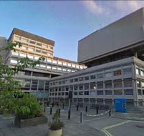
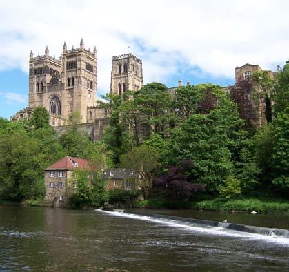
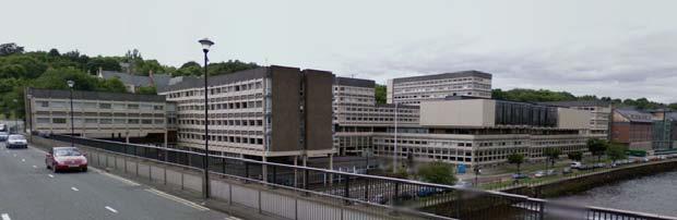
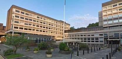
2 Introduction to the Brief Background The Milburngate House site is a large and prominent City Centre site. It offers great potential for redevelopment and through this, an opportunity to enhance the City of Durham s image and character. The intention of the current central government owners National Savings and Investments (NS&I) is to relocate operations from this building, which has reached the end of its functional life, and to move to a nearby City Centre site, thus facilitating new development on their current site. This provides a unique redevelopment opportunity and a chance to attract investment and economic development into the City. The future of this important site is the focus of the Design and Development Brief, which is summarised in this document. Purpose of the Brief The Design and Development Brief sets the agenda for site redevelopment. It promotes high quality design and a contextually sensitive approach to architecture and place-making. Future development needs to be relevant to Durham and should contribute positively to the City. Redevelopment will have a profound impact on Durham and the riverside and should leave a legacy development, which is of exemplary quality. NS&I will be selling the site on the open market so the purpose of the brief is to help achieve vision and value, by establishing appropriate design principles for the site. This consultation document is not the full/detailed brief. It is a summary document which includes the key principles and parameters for consultation. The full brief is available from Durham County Council. Milburngate House overlooking the Riverside 2
3 Vision and Key Principles The vision for the Milburngate site is to create a new place which is distinctive to Durham and which contributes to the vitality and quality of life within the City. New development will embrace the riverside and open up the site to public access and greater connectivity. The public realm will be refreshed and enhanced, with new streets and spaces created. Uses will bring new life and activity to the site and develop a commercially viable and deliverable scheme over the short, medium and long term. Delivery to high design standards is also a fundamental part of the vision, as development will need to stand the test of time. The following design principles set the expectations at a strategic level; 1. Development will be economically, socially and environmentally sustainable, ensuring a robustness and flexibility. The best developments offer a rich variety and are adaptable so that they can endure over many years. These qualities need to be designed into new development from the outset. 2. Building design and specification will reflect the aspiration for a development which will be long lasting. Timeless qualities of urban design and architecture rather than high fashion are required on this important site. This does not require buildings to look old. It does require an appreciation of the grain, character and architecture of Durham and for new development to respond positively to this and the unique site opportunities. 3. A building which is identified as a detractor to the City s internationally recognised historic urban fabric will be removed and a new townscape created. This townscape will be memorable and appropriate to Durham. Creating a family of well related and complementary buildings which belong together, rather than one large architectural statement, will achieve the desired effect. 4. The riverside will be revitalised and pedestrian access to it will be improved. The river at this point will become a more integral part of the City Centre with better pedestrian links from the higher mid-town level. New uses will generate activity and footfall through the day and into the evening. Development will create a new and more positive relationship with the riverside, recognising flood risk, but creating a striking and attractive waterside setting. 5. New streets and spaces will open-up the site and create places for public enjoyment within and around the site. Investment in a high quality and long lasting public realm is seen as an integral part of the redevelopment of the site. These works will need to relate positively to the wider public realm across Durham City Centre and recent improvement schemes. 6. Uses and activities should be varied and mixed. Redevelopment brings an opportunity for new investment in the City, and a chance to develop new uses which are presently missing or under represented, within a world class heritage city. How this site relates to and complements other sites and parts of the City Centre needs exploration. The mix of uses will need to address both commercial viability and also the evolving planning framework for the City and this site. 3

4 The site and its Context The site is situated to the north of Durham City Centre on the western bank of the River Wear, extending from Leazes Road to the south, Framwellgate to the west, the River to the east and to the Radisson Hotel to the north. The existing building footprint is approximately 10,600sqm and the estimated developable area is 1.93 Ha. The document covers an extended site boundary which includes surrounding pedestrian and vehicle access ways Site area and context 2. Aerial Photograph of site 4

5 Urban Design Opportunities 5
6 Opportunities include the following: Recreating Durham s townscape - By removing Milburngate House there is great potential to create a more appropriately scaled and designed building which is more sensitively related to the site and context. The nature of the site means that it can accommodate large and tall buildings but clear principles are required to guide the form, mass and skyline. Potential relationship with Millennium Place Recently developed leisure and cultural destination at Walkergate and Millennium Place offers opportunities to expand Durham s cultural quarter by linking over and across the river via the Millennium (Pennyferry) bridge, via an improved pedestrian realm along Leazes Road or by a new bridge from Millennium Place. Views of the World Heritage Site (WHS) New buildings offer great potential to create views of the WHS from within the building and from external spaces. Existing views should be maintained and enhanced where possible, particularly views from Framwellgate and Framwellgate Waterside. Trees and Landscape The existing trees that separate Framwellgate from the site perform a number of functions including ecological and screening qualities as well as adding landscape and townscape character to the site. To the southern corner of the site and Framwellgate there is an opportunity to replace some of these trees with built frontages. Potential frontages There is great potential for new frontages to exist along Framwellgate Waterside and on Leazes Road and the southern portion of Framwellgate at the corner of leazes Road and Framwellgate. These should help animate the public realm. Relationship with The Gates and the retail core The direct adjacency with The Gates Shopping Centre offers the potential to connect into the retail core, however the barrier of the A690 and the orientation of the current Gates building make this difficult. Current pedestrian access is unattractive from Milburngate House and under Milburngate Bridge. Pedestrian connections and footfall The site has potential to draw from existing footfall flows along Leazes Road and Framwellgate Waterside. Redevelopment or refurbishment would also offer the opportunity to enhance these pedestrian routes. The key issue is to reduce the impact of fast moving traffic along Leazes Road and the junction of Leazes Road / Milburngate and Highgate. Vehicular access / egress Vehicular access is currently provided by driving under The Gates Shopping Centre onto Framwellgate Waterside. There is no direct access from Framwellgate but there is an existing egress from the site onto this road. Opportunities to improve vehicular access should be sought within the demonstrated constraints of the highway infrastructure / network. Panoramic and exceptional views out There are fantastic views out from the site as facilitated by the existing building which give a hint at the quality of outlook from a developed site through new architectural forms. This is a unique site which offers great potential to create a development which is both internally and externally exceptional in terms of space, views and architecture. 6

7 Technical Constraints 7
8 Existing Consultation Context on the Design Brief The preparation of this document was subject to a public consultation process, which helped to guide and refine content and approach. This took the form of a two day public exhibition and the display of information boards in the Town Hall in Durham and on the internet. This exhibition was focused mainly on design and development principles and different development options which gave examples of how the site could be regenerated based on these principles. The consultation took place on Friday 20th and Saturday 21st May Boards were presented displaying proposed design principles and a series of potential approaches to the site s redevelopment. The views of the attendees were gathered using a feedback form. Full analysis of the results is available separately and will be included in the final Brief. The headline points are as follows: 112 people attended the consultation and 44 people filled in feedback forms. 93% of those filling in a feedback form supported the redevelopment of the site. 16 out of the 17 design principles suggested were largely supported by those responding. As a result of the public consultation changes were made to the design principles and recommended approaches to land-use. The following principles were less favourably received. These have been considered in more detail since the consultation (see below): 1. Allowing vehicular access from Framwellgate (16 agreed, 14 disagreed). This is too close to draw any specific conclusion but given there are mixed views on this subject, it has been considered in further detail in preparing this document. 2. Removal of trees nearest the roundabout (3 agree, 21 disagree). There was a preference to retain these trees and in general trees should be retained. However, in this case there is a powerful urban design rationale to reintroduce the historic building frontage which was lost many years ago. 1. The public exhibition 2. People filling in feedback forms 1 2 8
9 Design Parameters A series of design parameters provide the controlling framework for redeveloping the site. The parameters set the ground rules and guidelines for prospective developers of the site. These are very important and should shape the key aspects of any design. Within this context there is great potential for interpretation and a variety of design solutions. The parameters are based around the following key themes: Land use parameters Connections and access parameters Open space, public realm and landscape parameters Development form parameters Street frontage parameters Materials parameters Land Use Parameters Development of the site should include a mix of uses. The uses listed below have been tested with Durham County Council in terms of Planning and Highways. These uses also present a realistic commercial proposition as verified through property market review. These uses have also been reviewed as part of public consultation. This is not a definitive list of acceptable planning uses and other uses may be appropriate and acceptable. It is advised that consultation with the Central Strategic Planning Team and with site owners NS&I take place as ideas about use are generated by developers, investors and design teams. Residential uses including higher density apartments and also houses. Car parking provision and the impact of new development and uses upon traffic levels on Framwellgate, Milburngate and the A690 should also be considered for all uses and the highway context may have implications for site capacity. The current position is that this road infrastructure is nearing capacity. The site already includes significant car parking and has approval for substantial office space, notwithstanding the building is operating well below this level. The baseline for traffic levels on site is the existing approved use. It should be noted that this is a sustainable site close to rail and bus infrastructure and so sustainable travel to and from the site will be encouraged. Retail or other town centre uses which could include one retail unit or a collection of retail units. Leisure and in particular, restaurants, cafes and bars. It is envisaged that the retail and leisure uses either together or individually would form part of a wider mixed use approach. The brief does not prescribe specific land uses. The previous consultation identified example schemes which could be acceptable to the Council and in moving this forward, it is sensible to consolidate these uses into the list above. The balance of any uses and the exact split between these would need to be agreed in the context of this brief. 9


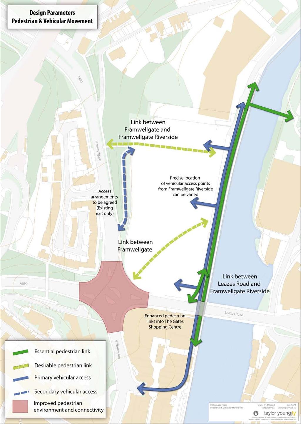
10 Connections and Access Parameters Cycle Access principles Pedestrian access principles This is a town centre site and as such it is vital that it is designed to provide much improved pedestrian accessibility and connectivity. A strong pedestrian connection should be maintained along Framwellgate Waterside as part of a riverside promenade. Road and pedestrian movements should be balanced and pedestrians and cyclists prioritised. New cycle facilities for secure covered storage at appropriate locations and with adequate provision of stands will be required to encourage and support bicycle journeys to the site and Town Centre. New development should also ensure adequate facilities are designed in for cycle storage and associated facilities. The most challenging requirement in respect of pedestrian connections will be to establish an accessible, legible and well-overlooked pedestrian route from Leazes Road at the higher (mid town) level to the lower level at Framwellgate Waterside. Also the connection to The Gates Shopping Centre under the road bridge will need improvement. The feasibility of an additional footbridge to Freemans Reach, Walkergate and Millennium Place should be considered. However given the prevailing economic climate the viability of any such bridge may be difficult and so this link is clearly aspirational and not a requirement. Vehicular Access / Traffic principles Primary vehicular access should be provided from Framwellgate Waterside, accessed from the existing access point underneath The Gates Shopping Centre via Milburngate. There is potential to use the existing ramped egress from the site onto Framwellgate as has historically been the case. The impact of proposed uses on the site on the A690 will be a key consideration defining the appropriate amount of development. This issue was highlighted when constraints were described and it was noted that at this stage there is not definitive advice from the Highway Authority as to the capacity within the existing network locally Poor pedestrian access to The Gates Shopping Centre 2. Traffic impacts on the pedestrian environment along Leazes Road 10
11 11

12 Open Space, Public Realm and Landscape Parameters Public Realm principles A well designed, high quality and pedestrian friendly public realm should be created across and throughout the site. The public realm should be fully accessible and the site levels do present a challenge to this, which will need to be creatively addressed. Design solutions should consider historical solutions to changes in levels and street design. Where accessible gradients are not achievable along streets to link the mid town and riverside levels, mechanical solutions will be required and these should be provided through and managed by the development (e.g. lifts or travelators). The footway and public realm along Leazes Road and the southern portion of Framwellgate is also an area for improvement, particularly in terms of pedestrian safety and traffic impact. Framwellgate Waterside is a key area for action and improvement. New development should include the land right up to the riverside in terms of the public realm envelope of the scheme and make provision for the significant improvement of this area as a public space. The existing road along the riverside should be retained in its broad location but should be narrowed through changes to parking arrangements and carriageway designed within a pedestrian priority scheme. 1. An underutilised riverside, designed for car parking rather than for people 2. An example of a more vibrant and pedestrian friendly riverside in Chester 3. Existing public space but poorly designed and used 12


13 Open Space principles A number of spaces should be created within the development serving a variety of functions ranging from small incidental spaces to larger more formal squares. There is flexibility about how this network of spaces is delivered but the need for a series of linked places within the development is underlined as a requirement. A centrepiece open space should be created within the site and this should have a relationship with the riverside, set back slightly from the riverside and supported by activity generating uses. The exact position of the space can be varied, however its location should respond to uses and movement routes. It is likely that this key public space will need to help resolve levels across the site and this should be an important aspect of the brief for the design of this space. Approach to Trees The belt of trees to the north-west of the site alongside Framwellgate and occupying the retaining slopes adjacent to it should be retained. Appropriate management and thinning of this area of trees may be necessary. The collective value of these trees is the important feature. It may be appropriate / possible to extend this green character across the site towards the riverside through new tree planting and landscaped areas. This concept should be explored through site masterplanning. The belt of existing trees by the Framwellgate / Leazes Road junction could be thinned or removed to enable the creation of a new street frontage. New formal / structural tree planting could be designed into a refurbished street environment. Avenue planting is promoted along the waterside to create a much greener and more convivial landscape character and microclimate species choice and spacing will be important as the intention should be to add value to the waterside and not to screen the river from development. Existing and future services along Framwellgate waterside will need to be considered in terms of street tree planting Typical small informal Durham space 2. Trees retained to Framwellgate 3. Trees opposite The Gates Shopping Centre 13
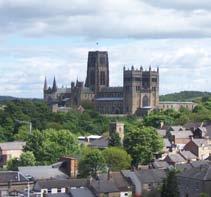
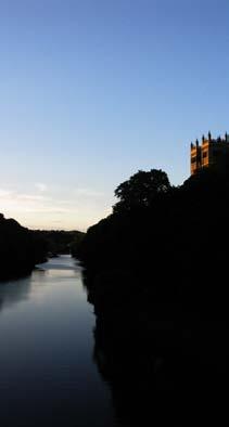
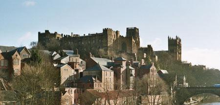
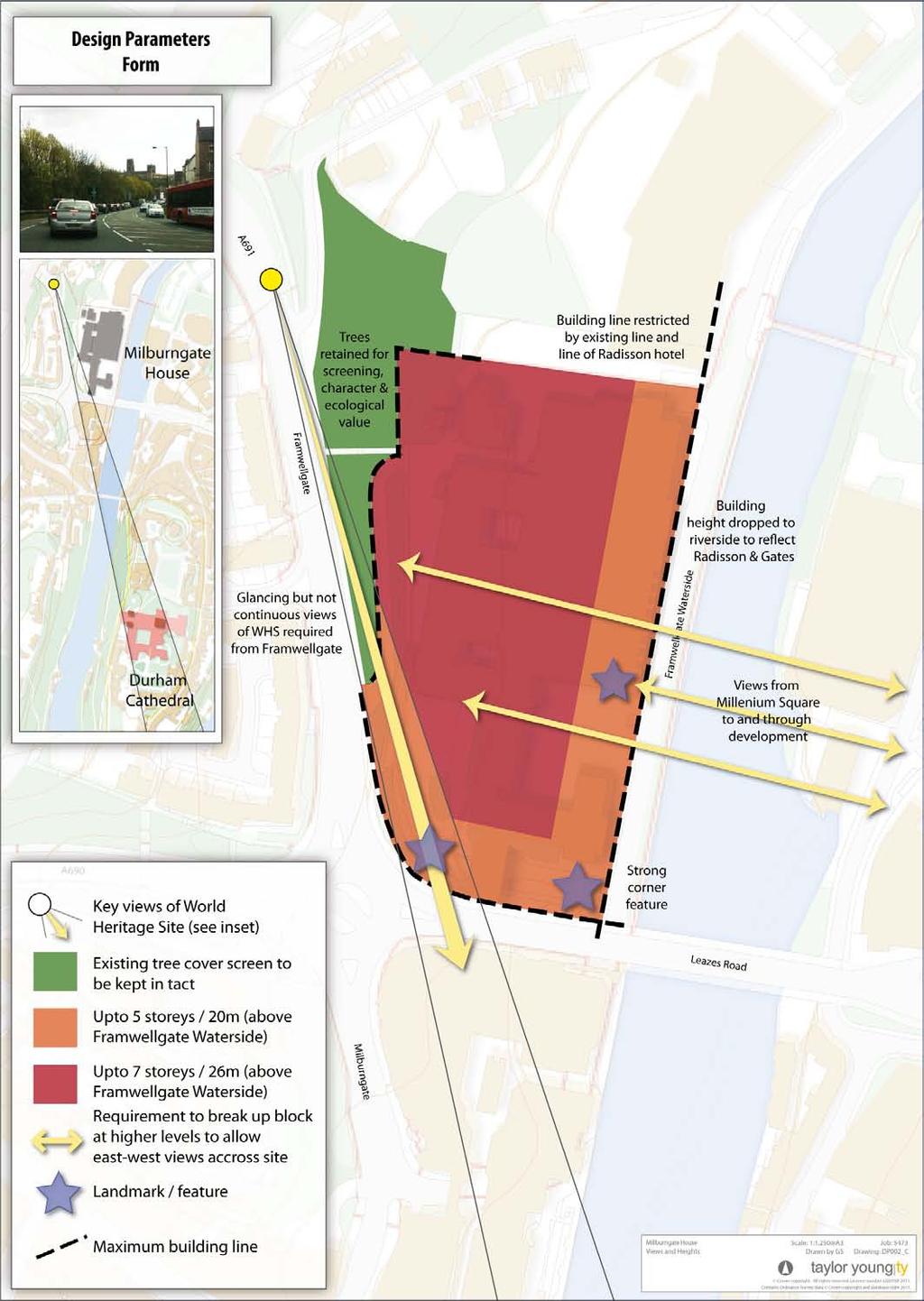
14 Development Form Parameters Building lines principles Approach to Key Views Site analysis identifies a series of important views of the site from around the town. In particular, views of the site and the World Heritage Site have been identified as most important. These views comprise lower level views from Framwellgate Waterside and higher level views from Framwellgate. Discussions with English Heritage confirmed that the view of Durham Cathedral (WHS), from Framwellgate is key as this street forms a gateway and approach to Durham City Centre. Redevelopment of Milburngate House must respect this view corridor and ensure that it is retained. Trees and buildings currently obscure and soften part of this view and so improvements will be possible in places through redevelopment. In seeking improvements to this view corridor, it is not necessary to maintain constant and unbroken views to the Cathedral along the full length of Framwellgate. Rather new views and glimpses can be created / retained to ensure the prominence and visibility of the Cathedral (WHS) is maintained. Views should not be substantially reduced and detailed assessment will be required as schemes are designed in detail. Controls over building height will help retain these long views. The views to the WHS from the redevelopment of Milburngate House will be impacted less at the lower waterside level as building lines will be set back from the river. Hence there will be building line controls rather than height controls in this location. As defined elsewhere, new buildings are encouraged at the corner of Framwellgate and Leazes Road to strengthen this important corner location. By introducing buildings at this location the local view to the WHS may be interrupted but this is acceptable providing other long distance views are provided along Framwellgate. That is, providing the design is complementary to the WHS being included in the view. New buildings frontages are also required at the waterside. This should not however be a solid wall of development. Break points in the building line will be appropriate, to create new streets and spaces and a more human scaled riverside promenade. The new building line should relate well to the Radisson Hotel. Building lines at the riverside could step back from the riverside to accommodate public realm and to accommodate flood mitigation and water storage areas. However, the need to enable enclosure of the river dictates that maximum set back distances for the greater proportion of buildings will be not more than 20 metres. Where possible the building line to the south and south-east should be brought forward to the edge of the footway / public realm to improve enclosure and develop a city scale and street scene. Pedestrian footways could be widened at this location to create a more comfortable pedestrian street (with greater space between pedestrians and cars). It is envisaged that the building line to the north-west should not go beyond the existing retaining wall structures and should not encroach onto the existing trees and embankment. Whilst this part of the development will be less visible, good quality frontages and architecture will be necessary and buildings should not turn their back on Framwellgate. 14
15 15
16 Building Heights principles Controls on building heights are identified to ensure an appropriately scaled design response and to protect views of the World Heritage Site. New development should reflect and respond to the form, height and roofline of Durham City Centre. Notwithstanding this, the site can accommodate tall development and the height controls placed on development reflect this, creating buildings of appropriate scale and stature for the site. An envelope has been identified within which new buildings will need to be accommodated. This has been defined to simply convey the key requirements for redevelopment in relation to the existing building and context. Across the site, buildings up to 5 storeys or 20 metres will be acceptable (to ridge or equivalent) as measured from the base of buildings at the riverside. At the riverside, this control limits buildings in so that they are broadly in line with both the Radisson Hotel and The Gates Shopping Centre. This control also protects the long range views along Framwellgate to the WHS. The building height should be varied along the length of the riverside frontage in particular and around the site more generally to create a varied impression and an interesting skyline Massing zone at Riverside 2. 3D model of existing building 3. Massing zone at Framwellgate 4. Massing zone at Leazes Road
17 Deeper into the site, taller buildings will be acceptable and this zone is indicated on the associated plan. The upper limit for taller buildings in this location is 7 storeys or 26 metres to ridge. Taller buildings in this location are encouraged to create a tiered effect to the buildings on site (see next bullet). Typically, buildings reflect the terrain in Durham and so there is often the visual impression of buildings stepping up and across rising / falling ground. Whilst this site is essentially a flat site, with a level plinth created across the site, there is an opportunity for new buildings to reflect this stepping effect through careful and controlled use of building heights, and this approach is encouraged. (at this location) is important and hence building heights are controlled here to ensure new development is set below the crest of the tree canopy. The interplay of buildings and trees is a characteristic part of Durham s townscape. A signature building could be acceptable rising above 26 metres providing it does not impact adversely on views of the WHS. Any such building should be iconic, slender and of the highest quality. The height of this building will be judged on its townscape merits. Any such signature building should have a maximum height of no greater than the existing building. This suggests that new building at no greater height than 34metres. The height control of up to 26 metres will be low enough to make visible the retained trees along Framwellgate. These trees are an important feature when viewing new development from Millennium Place. This green backcloth to the City Existing townscape stepping up the hill 2. Building rising up from the Riverside 3. Massing zones from Walkergate 4. Massing zone from Riverside towards WHS


 More modern development in the City also highlights different ways to create points of interest through architectural forms.")
18 Approach to Landmarks / Landmark Features Landmark features should be used to define key corners and vista points within the site. At these locations taller buildings and/or feature elements may be appropriate to reinforce legibility, but these remain governed by the overall height controls. Skyline features may be part of this architectural approach but again the maximum height controls apply. It should be noted that landmark features can comprise many forms and do not necessarily require added height to generate the desired impact. Durham s historic townscape provide numerous examples of locally distinctive townscape features which can provide inspiration for designers on this site. See photograph (below) More modern development in the City also highlights different ways to create points of interest through architectural forms. See photograph (right) There is scope for a tall landmark / skyline building set within a wider townscape fabric. This will echo the traditional grain of the city, with lower buildings punctuated by spires and towers. 18

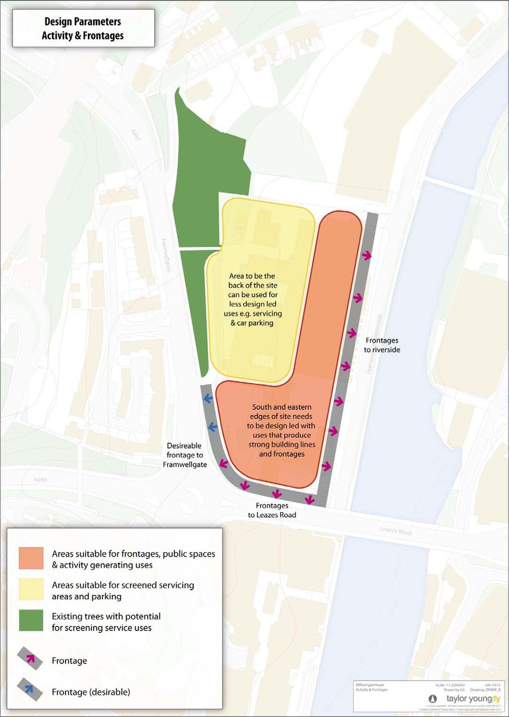
19 Street Frontage Parameters Frontages and Enclosure principles Strong new built frontages should be created addressing the waterside and Leazes Road, including the corner at Leazes Road and Framwellgate. A built frontage is also desirable and encouraged along the southern portion of Framwellgate. Strong frontages require enclosure and continuity of street space through buildings of appropriate scale and design quality. There may be scope to break these frontages to allow access into the site and to break down the grain of the site and define individual plots. Street Level / Ground Floor Activity principles A key design challenge for this site is to create active street level frontages across the site whilst also resolving the change in level between the riverside and Leazes Road. This should be achieved through buildings and public realm designed together. At the riverside, flood risk mitigation will dictate that the finished floor level to buildings will be set higher than existing public realm. The design of the riverside space should avoid the need to set building frontages high above the street level. It will be desirable for some buildings to provide multi-level access and frontages (and entrances) at different storey, but this should be in addition to public / external connections within the wider public realm. Service, private access areas and/or areas of open parking should be located to the north and west of the site, where they can be screened by existing trees, by changes in level and by new buildings (or a combination of these). Design solutions need to recognise that there are two key street levels within the site - the waterside and Leazes Road. These will be linked (in some way) and the two levels and linking streets / spaces designed to include lively and active frontages. A distinction is made between buildings which are activity generators; for example shops, restaurants and so on and other uses such as houses, which generate far less activity by way of coming and going. Activity generating uses should be located towards the south and east of the site, benefitting from movement routes and greater levels of existing footfall. These should invite people into the site and develop footfall flows into the site and towards the riverside. See photograph (right). 19
20 20
.")
. Recent development at Highgate replicates traditional proportions.")
21 Street / Building Proportions The aim in the new development is to create streets which are of a scale and proportion that naturally fit within Durham City Centre. Vertical proportions through plot and building sub-division is characteristic of Durham Streets. Controlled variety along the street and vertical proportions are required. See photograph (right). Strong street enclosure in traditional Durham streets with taller buildings and intimate spaces. This overall approach and effect of proportion should be replicated through new development. See photograph (right). Recent development at Highgate replicates traditional proportions. The architectural treatment need not however be traditional in development of similar proportion at Milburngate House. The gentle sweep of the street up and around the sloping ground is also characteristic to Durham working together. The design of the street to accommodate a change in level in this way could provide inspiration for addressing the change in level at Milburngate House. See photograph (right and below). New development should replicate these proportions irrespective of the architectural style employed. Contemporary or traditional buildings can adopt this Durham scale and proportion. 21
22 Material Parameters A family of traditional building materials, colours and finishes make Durham s historic buildings and streets distinctive and generate an overall impression which is both familiar and place specific. Materials for buildings and public realm should draw upon this family or palette of materials in a sensitive and creative manner to achieve a continuation in Durham s distinct sense of place. This is equally important whether or not the architectural style is traditional (as at Highgate) or contemporary. See photograph (Below right). There should be a clear narrative and evidence as to why materials, colours and finishes for all aspects of buildings and public realm are selected set against this approach. Materials must be fit for purpose, robust and be specified, constructed and detailed to stand the test of time. Materials for buildings and public realm should respond positively to the wider City Centre. Materials must have a sense of coherence and integrity as part of the building and its architecture. The form and articulation of a building, of a street or a series of buildings can be translated through a carefully specified palette of materials which contrast and complement together and within the overall coordinating framework of Durham s existing townscape. This is not about dressing new buildings up to look old. It is about ensuring that whatever the style of building the overall theme is one which belongs in Durham. Strong and deliberate contrast from the prevailing palette of materials will generally be discouraged, other than, where this is used subtly to provide accentuation to key elements, for example to highlight a key corner, prominent elevation or entrance. For these important features careful consideration should be given to the colour, nature and finish of these accent materials. Colour is particularly important in dealing with this sensitive site. Light colours with reflective surfaces can prove very detrimental to the creation of a harmonious and settled townscape, which has a sense of permanence, appropriateness and contextual relevance. Typically darker and more recessive colours picking up local stone and brick tones for walling and dark slates for roofing should be a baseline position. 22
23 Summary Feedback on this Consultation Document This brief establishes numerous requirements for development at Milburngate House. The intention is to set key controls and to promote a highly context specific approach. Despite the amount of information, there remains scope to be innovative and creative through site design and masterplanning. To understand how proposals will be assessed against the brief, the following section includes a design review table which may be used to assess proposals. Views and feedback are now sought on this consultation document. Do the principles fit with your own aspirations for the site and will they promote high and appropriate design standards for the site within the Durham context? Consultation feedback is required by Friday 11th November 2011 and should be directed to: support@durhamcityvison.com Each of the key aspects of the brief is summarised to enable qualitative design review. As a reminder of the key issues within the document the following table is provided. Vision and Key Principles Parameters Land Use Parameters Connections and Access Parameters Open Space, Public Realm and Landscape Parameters Development Form Parameters Frontages, enclosure and activity at street level Street Frontage Parameters Street Building Proportions Materials for buildings and public realm 23
24
2.0 Strategic Context 4
 2.0 Strategic Context 4 2.1 The Area Action Plan is a non-statutory plan, which forms a corporate policy document, expressing particular issues and areas of concern while also providing a vision for the
97 Lea Bridge Road, Leyton, E10 7QL London Borough of Waltham Forest December 2015
 97 Lea Bridge Road, Leyton, E10 7QL London Borough of Waltham Forest December 2015 Public Realm and Landscape Proposals LEA BRIDGE ROAD, WALTHAMSTOW Public Realm & Landscape Proposals BDP(90)RPT001 December
Page 1 of 19 URBAN DESIGN FRAMEWORK FOR BOLTON STREET WATERFORD
 Page 1 of 19 URBAN DESIGN FRAMEWORK FOR BOLTON STREET WATERFORD 1.0 Introduction: The relocation of the City Council stores and depot from Bolton Street creates an exciting opportunity for development
Tall Buildings Strategy
 Chapter 8 Tall Building Strategy Mayor of London 115 existing & consented tall buildings effect on views of palace of westminster Chapter 8 Tall Buildings Strategy tall building cluster upto 150m with
3.1 The hybrid planning application proposes the following description of development:
 CHAPTER 3: PROPOSED DEVELOPMENT 3.1 The hybrid planning application proposes the following description of development: Hybrid (part-outline/part-full) planning application for a single composite development
8.0 Design and Form of Development 43/
 42/ 8.0 Design and Form of Development 43/ Rothwells Farm, Golborne/ Development Statement Figure 7. Site Constraints Key 44/ Site Boundary 360 Bus Route/Stops Existing Trees Underground Water Pipe Sensitive
Workshop 3. City of Burlington Waterfront Hotel Planning Study. September 14, The Planning Partnership
 Workshop 3 City of Burlington Waterfront Hotel Planning Study September 14, 2017 The Planning Partnership The Waterfront Hotel Planning Study 01 The Brant & Lakeshore Planning Study will establish a Strategic
Design Review Report Former YMCA Building, Bridgend DCFW Ref: N164 Meeting of 12th April 2018
 Design Review Report Former YMCA Building, Bridgend DCFW Ref: N164 Meeting of 12 th April 2018 Review Status PUBLIC Meeting date 12 th April 2018 Issue date 18 th April 2018 Scheme location Bridgend Scheme
Mark-up of the effect of the proposed Bronte Village Growth Area OPA No.18 on the text of section 24, Bronte Village, of the Livable Oakville Plan
 Mark-up of the effect of the proposed Bronte Village Growth Area OPA No.18 on the text of section 24, Bronte Village, of the Livable Oakville Plan Notes: This document is provided for information purposes
Newcourt Masterplan. November Exeter Local Development Framework
 Newcourt Masterplan November 2010 Exeter Local Development Framework Background The Exeter Core Strategy Proposed Submission sets out the vision, objectives and strategy for the development of Exeter up
Chapter 2: OUTLINE PLANNING APPLICATION PROPOSALS. A New Garden Neighbourhood Matford Barton 17
 Chapter 2: OUTLINE PLANNING APPLICATION PROPOSALS A New Garden Neighbourhood Matford Barton 17 2.1. SUMMARY AND STATUS OF THE PROPOSALS 2.1.1. The parameter plans and associated wording in this chapter
Urban Design Manual PLANNING AROUND RAPID TRANSIT STATIONS (PARTS) Introduction. Station Study Areas
 Introduction. Station Study Areas") 111111 PLANNING AROUND RAPID TRANSIT STATIONS (PARTS) Introduction The ION rapid transit system will link Waterloo, Kitchener and Cambridge through a central transit corridor (CTC). There are a number
111111 PLANNING AROUND RAPID TRANSIT STATIONS (PARTS) Introduction The ION rapid transit system will link Waterloo, Kitchener and Cambridge through a central transit corridor (CTC). There are a number
WELLINGTON HOSPITAL DESIGN GUIDE TABLE OF CONTENTS
 WELLINGTON HOSPITAL DESIGN GUIDE TABLE OF CONTENTS 1.0 Introduction Page 2 The Place of Wellington Hospital 2 The Future of the Hospital 2 2.0 The Intention of the Design Guide 3 3.0 Analysis 4 General
3.3. Urban Structure Defining a New Hierarchy of Routes and Spaces >Images
 Section 3.0 I The Masterplan Framework 18 >Images Examples of high quality routes and spaces 3.3. Urban Structure The success of any masterplan lies in a clear definition of the future urban structure
Response to the London Bridge Area Vision and Site Allocations within the New Southwark Plan
 1 Melior Place London SE1 3SZ 020 7407 4701 teamlondonbridge.co.uk info@teamlondonbridge.co.uk 28 April 2017 Response to the London Bridge Area Vision and Site Allocations within the New Southwark Plan
Policies and Code Intent Sections Related to Town Center
 Policies and Code Intent Sections Related to Town Center The Town Center Vision is scattered throughout the Comprehensive Plan, development code and the 1994 Town Center Plan. What follows are sections
Design Guidance. Introduction, Approach and Design Principles. Mauritius. November Ministry of Housing and Lands. .. a
 sig evelo r D Mauritius s. Utilities.. Individu a s. er itects.to ls chpers.po e Public. T. h rban D Sc U e me Promot e h ners. A Design Guidance o.h Planne rs n w iticians r l useholde National Development
0 9 Areas of Change 59
 09 Areas of Change 59 09 Areas of Change This section explores seven areas of change within Solihull Town Centre which provide practical interventions in order to deliver the emerging concepts outlined
Huddersfield Urban Design Framework. 3. Framework
 3. Framework The illustrative plan has been used as the basis for developing an urban design framework and strategy in Part 3 of this report. This is based on a series of regulatory plans that code the
A. The sites in Table 16 below, as identified on the Policies Map, are allocated for retail-led development:
 SWDP 44: Worcester City Centre A. The sites in Table 16 below, as identified on the Policies Map, are allocated for retail-led development: Table 16: Sites Allocated for Retail-Led Development Policy Reference
DISTRIBUTION OF MASS / ARTICULATION TALLER BUILDINGS LOCATION ORIENTATED TO MINIMISE OVERSHADOWING TO PUBLIC AMENITY SPACES.
 DISTRIBUTION OF MASS / ARTICULATION TALLER BUILDINGS LOCATION ORIENTATED TO MINIMISE OVERSHADOWING TO PUBLIC AMENITY SPACES. - HEIGHT USED TO MARK DESTINATION - MINIMISE OVERSHADOWING. - CREATE RHYTHMIC
WHITELEY TOWN COUNCIL NORTH WHITELEY DEVELOPMENT SEPTEMBER 2014
 WHITELEY TOWN COUNCIL NORTH WHITELEY DEVELOPMENT SEPTEMBER 2014 Dear Resident This Special Edition of the Whiteley Voice which has been prepared in conjunction with the North Whiteley Consortium is to
Statement of Community Involvement LAND OFF SOUTHDOWN ROAD HORNDEAN, HAMPSHIRE
 LAND OFF SOUTHDOWN ROAD HORNDEAN, HAMPSHIRE CONTENTS Page 1. Introduction 3 2. Pre-application Discussions 4 3. The Consultation Process 5 4. Consultation Feedback 7 5. Responses to Consultation Feedback
Vision for Irvine: a self-confident town where people aspire to live and work and which they are proud to call home
 Vision for Irvine: a self-confident town where people aspire to live and work and which they are proud to call home Stunning view out to the harbourside Artist s impression of how the Bridgegate area could
Artists impression of the Park Promenade and plot H4 with café and restaurant uses that is still subject to change
 The Park Promenade Artists impression of how a café might look Artists impression of the Park Promenade and plot H4 with café and restaurant uses that is still subject to change Precedent images for balconies
URBAN DESIGN BRIEF URBAN DESIGN BRIEF 721 FRANKLIN BLVD, CAMBRIDGE August 2018
 URBAN DESIGN BRIEF URBAN DESIGN BRIEF 721 FRANKLIN BLVD, CAMBRIDGE August 2018 DESIGN BRIEF CONTENTS PART A 1.0 INTRODUCTION 2.0 DESCRIPTION & ANALYSIS OF SITE CONTEXT 3.0 DESIGN CONSTRAINTS AND OPPORTUNITIES
TALL BUILDING GUIDELINES
 TALL BUILDING GUIDELINES Urban Design Guidance for the Site Planning and Design of Tall Buildings in Milton May, 2018 A Place of Possibility Contents 1.0 INTRODUCTION 1 1.1 What is a Tall Building? 2
Colchester Northern Gateway Master Plan Vision Review Draft. July 2016
 Colchester Northern Gateway Master Plan Vision Review Draft July 2016 Contents Introduction 4 Context 8 Purpose of the Report 8 Strategic Position 9 Overview of the Process 11 2012 Master Plan Vision 12
BLETCHLEY PARK AREA - DEVELOPMENT FRAMEWORK
 ANNEX A To Item 9 REVISED TEXT: additions shown bold and underlined, deletions in (brackets and in italics). BLETCHLEY PARK AREA - DEVELOPMENT FRAMEWORK This framework sets out the key objectives and requirements
Longbridge Town Centre Phase 2 Planning Application
 Longbridge Town Centre Phase 2 Planning Application Non-Technical Summary of the Environmental Statement December 2013 Introduction A full application for Planning Permission has been submitted to Birmingham
Keystone Business Park Precinct Structure Plan North East Industrial Precinct. Part 2 Design Principles
 Keystone Business Park Precinct Structure Plan North East Industrial Precinct Part 2 Design Principles Context Issues Services Landform Issues Geotech and contamination Ecology Traffic and access Issues
Introduction to MP3. MP3 H4 Park Central (North)
") MP H4 Park Central (North) Introduction to MP A visualisation of the Illustrative Masterplan with MP shaded in blue MP is the third phase of the Elephant Park regeneration and is bounded by on the north,
MP H4 Park Central (North) Introduction to MP A visualisation of the Illustrative Masterplan with MP shaded in blue MP is the third phase of the Elephant Park regeneration and is bounded by on the north,
Horwood Map of London, Westminster & Southwark First edition
 Barratt London is developing plans in tandem with Southwark Council and TfL to transform the southern end of Blackfriars Road. The residential-led, mixed-use scheme will deliver new private and affordable
heuston gateway: sections heuston gateway: regeneration strategy and development framework plan
 B B1 A B1 B C A heuston gateway: sections B B1 C 117 4.3.3 Zoning The station is the central hub of the area and this function must be preserved and developed. However large areas of the Heuston Station
Chapter 5 Urban Design and Public Realm
 5.1 Introduction Public realm is all areas of the urban fabric to which the public have access. It is where physical interaction takes place between people. It therefore, includes buildings and their design,
design & access statement Proposed Erection of 68 Bedroom Hotel and Restaurant with Associated Landscaping
 Proposed Erection of 68 Bedroom Hotel and Restaurant with Associated Landscaping Promenade, design & access statement lawrencemcphersonassociates 6 new road, ayr, ka8 8ex On Behalf of July 2015 CONTENTS
Description Details submitted pursuant to discharge of condition 5 (Design Code) attached to planning permission 13/01729/OUT.
 attached to planning permission 13/01729/OUT.") ITEM 9 Application Number: 18/00266/DISCON Description Details submitted pursuant to discharge of condition 5 (Design Code) attached to planning permission 13/01729/OUT. AT The Point, 602 Midsummer Boulevard,
ITEM 9 Application Number: 18/00266/DISCON Description Details submitted pursuant to discharge of condition 5 (Design Code) attached to planning permission 13/01729/OUT. AT The Point, 602 Midsummer Boulevard,
Ipswich Issues and Options for the Ipswich Local Plan Review, August 2017, Public Consultation
 Ipswich Issues and Options for the Ipswich Local Plan Review, August 2017, Public Consultation Having reviewed the issues and options documents, the Society has made the following response: Part 1 Strategic
[PLANNING RATIONALE] For Site Plan Control and Lifting of Holding Zone By-Law 101 Champagne Avenue. May 23, 2014
![[PLANNING RATIONALE] For Site Plan Control and Lifting of Holding Zone By-Law 101 Champagne Avenue. May 23, 2014](/thumbs/75/71599615.jpg "[PLANNING RATIONALE] For Site Plan Control and Lifting of Holding Zone By-Law 101 Champagne Avenue. May 23, 2014") [PLANNING RATIONALE] For Site Plan Control and Lifting of Holding Zone By-Law 101 Champagne Avenue May 23, 2014 Contents 1.0 Introduction... 2 2.0 Site Context... 2 2.1 Adjacent Uses... 2 Figure 1: Site
[PLANNING RATIONALE] For Site Plan Control and Lifting of Holding Zone By-Law 101 Champagne Avenue May 23, 2014 Contents 1.0 Introduction... 2 2.0 Site Context... 2 2.1 Adjacent Uses... 2 Figure 1: Site
PLANNING STATEMENT. Market House Market Place Kingston upon Thames KT1 1JS
 PLANNING STATEMENT To support planning and listed building consent applications for change of use from Class A1 shop and Class A3 cafe to Class A3 restaurant at: Market House Market Place Kingston upon
STATEMENT OF OBJECTION TO THE PROPOSED DEVELOPMENT OF LAND AT CHURCH CLIFF DRIVE FILEY
 STATEMENT OF OBJECTION TO THE PROPOSED DEVELOPMENT OF LAND AT CHURCH CLIFF DRIVE FILEY You will be aware that Scarborough borough council have adopted a new local plan that includes land at Church Cliff
Vision for East Cowes
 Vision for East Cowes A better East Cowes for now and the future The East Cowes Regeneration project is a major regeneration scheme on the Isle of Wight. It will create a vibrant community with a long-term
Sustainability Statement. Whitby Business Park Area Action Plan
 Sustainability Statement Whitby Business Park Area Action Plan November 2014 Contents Page 1. Introduction 1 2. Scoping 3 3. Sustainability Appraisal of Options 6 4. Assessment of Draft Area Action Plan
New-Cast Mixed-use Development Proposal King Street West, Newcastle, Ontario
 URBAN DESIGN BRIEF New-Cast Mixed-use Development Proposal King Street West, Newcastle, Ontario TABLE OF CONTENTS: 1.0 Executive Summary 2.0 Creating Vibrant and Sustainable Urban Places: Excerpts from
Official Plan Review: Draft Built Form Policies
 PG.30.1 REPORT FOR ACTION Official Plan Review: Draft Built Form Policies Date: May 15, 2018 To: Planning and Growth Management Committee From: Chief Planner and Executive Director, City Planning Division
Paignton Neighbourhood Plan (Submission version 2017)
") Paignton Neighbourhood Plan (Submission version 2017) Introduction This brief statement covers the views of the TDA, only in relation to its role as adviser to the Council on delivery of town centre regeneration.
Paignton Neighbourhood Plan (Submission version 2017) Introduction This brief statement covers the views of the TDA, only in relation to its role as adviser to the Council on delivery of town centre regeneration.
SUB AREA 3 CENTRAL STRATFORD AND SOUTHERN QUEEN ELIZABETH OLYMPIC PARK
 191 ADOPTED LOCAL PLAN: THE SUB AREAS SUB AREA 3 CENTRAL STRATFORD AND SOUTHERN QUEEN ELIZABETH OLYMPIC PARK SECTION 12 Vision VISION Central Stratford and Southern Queen Elizabeth Olympic Park will become
Welcome to our exhibition
 Welcome to our exhibition housing development A46 Wildmoor Alcester Road Canal Quarter A422 Town Centre housing development Warwickshire-based IM Properties, one of the UK s largest privately owned property
Long Branch Neighbourhood Character Guidelines Final Report
 STAFF REPORT ACTION REQUIRED Long Branch Neighbourhood Character Guidelines Final Report Date: October 26, 2017 To: From: Wards: Reference Number: Etobicoke York Community Council Director, Community Planning,
Uptown Rideau Street Secondary Plan [Amendment #166, January 12, 2016]
![Uptown Rideau Street Secondary Plan [Amendment #166, January 12, 2016]](/thumbs/76/73760497.jpg "Uptown Rideau Street Secondary Plan [Amendment #166, January 12, 2016]") [Amendment #166, January 12, 2016] The policies of this Secondary Plan are in effect, save and except for the property at 560 Rideau Street, for which there remains a site specific appeal to this Secondary
[Amendment #166, January 12, 2016] The policies of this Secondary Plan are in effect, save and except for the property at 560 Rideau Street, for which there remains a site specific appeal to this Secondary
PART 1. Background to the Study. Avenue Study. The Danforth
 The Danforth 1.1/ Study Purpose & Key Municipal Goals 1.2/ The Local Advisory Committee 1.3/ The Project Team 1.4/ Study Process/Summary of Method 1.5/ Summary of Consultation 1.1 Study Purpose and Key
Urban Design Guidelines
 Urban Design Guidelines These Urban Design Guidelines comprise the Key Design Objectives below, the Roads Design Guidelines overleaf and Neighbourhood Framework Plans. Together with Section 3: Urban Design
4 Proposed masterplan 4.1 Proposed masterplan: The scheme The scheme s component parts Urban form and grain
 4 Proposed masterplan 4.1 Proposed masterplan: The scheme... 36 4.2 The scheme s component parts... 36 4.2.1 Urban form and grain...36 4.2.2 Retail Circuits...38 4.2.3 Mix of uses...39 4.2.4 Public realm...40
Appendix A: Retail Planning Assessment
 Rotherham Town Centre Masterplan Appendix A: Retail Planning Assessment 139 Appendix A Rotherham Town Centre Masterplan Retail Planning Background and Policy Context 1. Introduction 1.1 The Masterplan
Barnstaple's new riverside quarter
 Artist's impression of completed site Welcome to our exhibition of plans for new homes and commercial phases 2a and 2b of Anchorwood Bank. Anchorwood Bank is the most important development site in Barnstaple.
WINDSOR GLEN DESIGN GUIDELINES
 WINDSOR GLEN DESIGN GUIDELINES Adopted by Council, 2006 WINDSOR GLEN REDEVELOPMENT DESIGN GUIDELINES August 2006 1.0 Master Plan Organization For this area of the Coquitlam Town Centre, a mix of high,
REPORT BACK BROADSHEET 3 May 2016
 Paddington Place REPORT BACK BROADSHEET May 06 Architects and planners should work with the community first and then thinking about developers profits second. - Quote from participant at Paddington Place
QUEEN-RIVER SECONDARY PLAN
 34 QUEEN-RIVER SECONDARY PLAN 34. QUEEN RIVER SECONDARY PLAN 1. INTRODUCTION The Queen-River area is approximately 6.4 hectares and is located at the eastern edge of the Downtown as shown on Map 34-1.
DRAFT Northeast Quadrant of Kipling Avenue and Highway 7 DRAFT AUGUST 29, Goals Land Use. The goals of this Plan are to:
 AUGUST 29, 2017 12.15 Northeast Quadrant of Kipling Avenue and Highway 7 12.15.1 Goals 12.15.2 Land Use The goals of this Plan are to: 12.15.2.1 General Provisions: a) Ensure the development of a compact
10 Proposed Redevelopment, Tewkesbury Road, Cheltenham SCHEME EVOLUTION STARBUCKS
 SCHEME EVOLUTION STARBUCKS The proposed Starbucks Drive Thru alongside the proposed food store provides an appropriate mix of uses, suitable for this location. The proposed store is bespoke, designed specifically
NORTH CIRCULAR ROAD - REGENERATION IN ACTION
 NORTH CIRCULAR ROAD - REGENERATION IN ACTION Notting Hill Housing is a social enterprise which has been at the forefront of vibrant urban regeneration since 1963. Notting Hill has over 25,000 homes across
01 the vision NEW LYNN IS WAITING FOR THE GREAT LEAP FORWARD
 [A] FRAMEWORK 01 the vision 02 the framework 03 urban design principles 04 c o n t e x t 05 issues a n d o p p o r t u n i t i e s 06 creating a t.o.d. 07 key recommendations 08 seven strategic areas of
MATURE SUBURBS RESIDENTIAL DEVELOPMENT GUIDELINES
 MATURE SUBURBS RESIDENTIAL DEVELOPMENT GUIDELINES DRAFT FEBRUARY 2005 BIRMINGHAM CITY COUNCIL 1 Introduction Mature Suburbs Residential Development Guidelines - Interim Supplementary Planning Advice -
COURTHOUSE CAMPUS BARNSLEY Executive Summary March 2010
 COURTHOUSE CAMPUS BARNSLEY Executive Summary March 2010 Estell Warren Cartwright Pickard Buro Happold King Sturge BWA Barnsley Metropolitan Borough Council introduction Courthouse Campus is the last major
appendix and street interface guidelines
 appendix five: building and street interface guidelines appendix 5 building and street interface guidelines BOULEVARDS Boulevards are generally characterized by higher levels of traffic movement at higher
Former Keighley College Buildings, North Street
 Introduction The Vision To create a high quality, mixed-use destination that will lead to the successful redevelopment of the site and contribute to the wider regeneration of the town centre The Opportunity
SWLP 42: Worcester City Centre
 SWLP 42: Worcester City Centre A. The following sites are allocated for retail development (as shown on the Proposals Map): Policy Reference SWDP7/1 SWDP7/2 SWDP7/3 Sites allocated for retail development
LINDEN HOMES McArthur s Warehouse, Gas Ferry Road. Welcome. Feedback
 LINDEN HOMES McArthur s Warehouse, Gas Ferry Road Welcome Linden Homes, part of Galliford Try plc, would like to redevelop the McArthur s Warehouse site off Gas Ferry Road on Bristol s harbourside. Linden
West Blackhall Street Public Realm Public Exhibition
 West Blackhall Street Public Realm Public Exhibition Welcome Introduction Thank you for coming to this public engagement, your input is sought to help to deliver high quality public realm improvements
Former North Works, Lickey Road, Longbridge, Birmingham
 Committee Date: 14/11/2013 Application Number: 2013/06431/PA Accepted: 27/08/2013 Application Type: Full Planning Target Date: 26/11/2013 Ward: Longbridge Former North Works, Lickey Road, Longbridge, Birmingham
WELCOME. Welcome to our second public exhibition on proposals for the redevelopment of the Paddington Central Management Office.
 WELCOME Management Office Paddington Central Welcome to our second public exhibition on proposals for the redevelopment of the Paddington Central Management Office. Following feedback from meetings with
WEST LOOP DESIGN GUIDELINES CHECKLIST
 WEST LOOP DESIGN GUIDELINES CHECKLIST Section 1.0 General Strategies 1.1 DESIGN EXCELLENCE: ENCOURAGE HIGH QUALITY AND INNOVATIVE DESIGN OF NEW BUILDINGS WITHIN THE WEST LOOP WITHOUT BEING PRESCRIPTIVE
Stoke Newington High Street 1.0 Site Analysis
 1.0 Site Analysis 9-11 Stoke Newington Church Street Grade II Existing Entrance via Wilmer Place Stoke Newington Church Street 187-191, 18th C; Grade II* including forecourt wall, railings and gates Rights
13. London Bridge London Bridge Area Vision
 13. 13.1. Area Vision 13.1.1. is: A globally significant central London business district which is home to international business headquarters; Internationally renowned for its prominent riverfront location
Site 5 Development Brief
 Union Street Crichton Street South Crichton Street Thomson Avenue (Northern Boulevard) Site 5 South Union Street Earl Grey Place West Site 6 Riverside Esplanade (Southern Boulevard) South Crichton Street
Eastbourne Borough Council. Summary Proof of Evidence Of Barry John Cansfield BA (Hons), BTP, MRTPI on behalf of PRLP
, BTP, MRTPI on behalf of PRLP") Eastbourne Borough Council (Arndale Centre and surrounding Land at Terminus Road, Sutton Road and Ashford Road) (Compulsory Purchase Order 2015) Section 226 (1)(a) of the Town and Country Planning Act
Eastbourne Borough Council (Arndale Centre and surrounding Land at Terminus Road, Sutton Road and Ashford Road) (Compulsory Purchase Order 2015) Section 226 (1)(a) of the Town and Country Planning Act
Welcome. Walk Around. Talk to Us. Write Down Your Comments
 Welcome This is an information meeting introducing the applications for proposed redevelopment of the Yorkdale Shopping Centre site at 3401 Dufferin Street and 1 Yorkdale Road over the next 20+ years,
Cotswolds AONB Landscape Strategy and Guidelines. June 2016
 Cotswolds AONB Landscape Strategy and Guidelines June 2016 Cotswolds AONB Landscape Strategy and Guidelines Introduction The evolution of the landscape of the Cotswolds AONB is a result of the interaction
Neighbourhood Planning Local Green Spaces
 Neighbourhood Planning Local Green Spaces Introduction... 2 1. Why green space is important... 4 2. Neighbourhood plans and green space... 6 3. Evidence... 8 Statutory designations... 9 Green space audit...
New Street Proposed Redevelopment Architecture & Urban Design Brief
 2130 2136 New Street Proposed Redevelopment Architecture & Urban Design Brief Prepared By: Cynthia Zahoruk Architect Inc. 3077 New Street, Burlington, ON, L7N 1M6 TABLE OF CONTENTS Background and Objective
Can town centres retain the social heart of our communities?
 Urban Design Group Solent - June 2013 Can town centres retain the social heart of our communities? Examples of strategic masterplanning and public realm design to re-invent urban centres Peter Frankum
PUTTING THE HEART INTO BATTERSEA. A vision
 PUTTING THE HEART INTO BATTERSEA A vision INTRODUCTION This document is a vision for creating a Battersea that its community can be proud of and it is about putting Battersea on the map. It is being proposed
13. New Construction. Context & Character
 13. New Construction Context & Character While historic districts convey a sense of time and place which is retained through the preservation of historic buildings and relationships, these areas continue
The Old Post Office Site
 The Old Post Office Site Welcome to our Second Exhibition St George is delighted to have acquired The Old Post Office Site. The site comprises: Kingston Town Centre The site is currently underutilised
Stowford Mill, Ivybridge Introduction
 Stowford Mill, Ivybridge Introduction 1. What is the purpose of this exhibition? Burrington Estates would like residents and interested parties to have the opportunity to review updated proposals for the
4. MASTERPLAN FRAMEWORK
 6a 6b 4. MASTERPLAN FRAMEWORK 6. Car Parks 6c Car Parks 6a and 6b will provide permanent parking. Area 6a will serve the foodstore with tarmac surfacing within a defined area to the west of the adjacent
edge of gas line corridor setback edge of gas line corridor aligned with Schlumberger building 37.0 m AOD 33.0 m AOD max
 7. Heights and Street Frontage: In accordance with the approved heights parameters, heights to along Western Access Road must respond to the existing low density character in this location. Heights are
Droitwich Spa 6. Reasoned Justification
 87 Droitwich Spa 6 Reasoned Justification 6.1 Droitwich Spa is identified in the settlement hierarchy (Policy SWDP1) as a main town being the largest settlement in Wychavon District with an estimated population
ILLUSTRATIVE MASTERPLAN
 ILLUSTRATIVE MASTERPLAN The Development Dairy Crest (Imperial College) The Proposed Development aims to create a new high quality residential neighbourhood, alongside a new public park for White City.
Design & Access Statement
 PI 007 RIBA Chartered Architects Design & Access Statement Ocean Beach Pleasure Park South Shields 1.0 Appraising the Context 1.1 Assessment of the sites immediate and wider context 1.2 Involvement Consultation
Making the case for Sustainable Transport Project Potential
 Making the case for Sustainable Transport Project Potential The Structural Investment Fund (SIF) Strategy for Greater Lincolnshire identifies the barriers to growth identified by having poor transport
WEST BLACKHALL STREET PUBLIC REALM + TOWN CENTRE CONNECTIONS Public Exhibition 28 th June 2018
 WEST BLACKHALL STREET PUBLIC REALM + TOWN CENTRE CONNECTIONS Public Exhibition 28 th June 2018 Welcome Introduction Design Your Involvement Thank you for coming Engagement We would like to gather to this
TABLE OF CONTENTS 1.0 INTRODUCTION... 3
 TABLE OF CONTENTS 1.0 INTRODUCTION... 3 1.1. BACKGROUND... 3 1.2. THE PROPOSAL... 5 2.0 EXISTING POLICY FRAMEWORK... 5 2.1. PROVINCIAL POLICY STATEMENT (PPS)... 5 2.2. CITY OF LONDON OFFICIAL PLAN (OP)...
City of Farmington. Downtown Plan. Amendment to the 1998 Master Plan Adopted October 11, 2004
 City of Farmington Amendment to the 1998 Master Plan Adopted October 11, 2004 Introduction Planning Background 1 Scope and Components of the Plan Amendment 2 Concept Introduction 3 Plan Concepts 3 Conceptual
3.1: The Masterplan Proposals
 .: The Masterplan Proposals Retail School..0. The majority of the retail units are focused along the vibrant High Street and the existing North End Road and Lillie Road...0. There are also retail units
17A. Wind Microclimate
 17A. Wind Microclimate 17A.1 Introduction 17A.1.1 17A.1.2 17A.1.3 17A.1.4 This Chapter, which has been prepared by Waterman and BMT, provides further information with regard to the potential wind microclimate
Kibworth Harcourt. Introduction. Introduction
 Introduction Introduction Welcome to this public exhibition on the proposals for the delivery of new homes on land at The Kibworths. The purpose of today s exhibition is to give you the opportunity to
5. Bankside and The Borough 5.1. Bankside and The Borough Area Vision
 5. 5.1. Area Vision 5.1.1. are: A globally significant central London business district which is home to international business headquarters; At the heart of the commercial and cultural life of the capital
PUBLIC REALM STRATEGY
 CONSULTATION DRAFT PUBLIC REALM STRATEGY Trenchard Street & Frogmore Street City Design Group Place Directorate Public Realm Strategy Trenchard Street & Frogmore Street Contents 1. Introduction 2. Understanding
GREENFORD HALL & ADJOINING LAND
 GREENFORD HALL & ADJOINING LAND CONTENTS 1. Introduction 1. Introduction 2. Urban Context 2.1 The Site and Surroundings 2.2 Urban Context Map 2.3 Access and Movement 3. Planning Context 3.1 Planning History