SH 199 Corridor Master Plan. Community Meeting No. 2 May 31, 2017
|
|
|
- Erika Norton
- 6 years ago
- Views:
Transcription


1 Community Meeting No. 2 May 31, 2017


2 Transportation Projects On or Near SH 199 SH 199 from 0.3 miles south of FM 1886 to south end of Lake Worth bridge Construct freeway mainlanes and frontage roads 10-Year Plan Funding: $85.3 million SH 199 from 0.3 miles south of FM 1886 to south end of Lake Worth bridge Construct freeway mainlanes and frontage roads 10-Year Plan Funding: $29.7 million FM 1220 at Azle Avenue Intersection improvements SH 199 from Azle Avenue to IH 820 Construct freeway mainlanes and interchange at IH Year Plan Funding: $200 million Total Investment $415 Million SH 199 from IH 820 to West Fork of Trinity River Reconstruct to 4/6 lane divided urban 10-Year Plan Committed Funding: $100 million North 2
3 Study Overview Limits: IH 820 to Belknap Length: 6 Miles Scope Existing Conditions Analysis Traffic Assessment Economic Market Analysis Stakeholder and Public Involvement Corridor Design and Operation o Drainage Assessment o Urban Design/Streetscape Alternatives o Multi-Modal Safety
4 Study Purpose and Goals Provide a basis for the future design of the roadway and develop a phased approach for making improvements to SH 199 Goals: Evaluate alternatives to maintain the flow of traffic through the corridor Provide transportation options for all modes Improve drainage Provide economic development opportunities
5 Challenges and Opportunities What is Great? Historical Context of the Corridor Parks in the Area Adjacent Neighborhoods Vistas and Views Redevelopment Opportunities What are the Challenges? Traffic Volumes Drainage Topography Number and Size of Driveways Speed Safety Pedestrian Access Making the Corridor Attractive to Businesses Adjacency to Park Land and a Historic Neighborhood What are the Opportunities? Right-of-Way Width Increase Pedestrian/Bike Connectivity to Parks and Trails Park and Ride near IH 820 More Mixed-Use Development Enhanced Urban Design
 1,191 vehicle crashes with 9 fatalities 18 pedestrian related")

6 Traffic Data 2016 Average Daily Traffic 1 30,050 to 35,800 vpd 2040 Projections 2 50,200 to 55,700 vpd Crash Data ( ) 1,191 vehicle crashes with 9 fatalities 18 pedestrian related crashes with 3 fatalities 3 bicycle related crashes with 0 fatalities VPD = vehicles per day 1 Based on Traffic Counts Taken in April Projected Traffic Volumes Based on NCTCOG Mobility 2040

 are")
7 Proposed Improvements Reconstruct and widen the existing roadway o 6 lanes from IH 820 to University Drive/Northside Drive o 4 lanes from University Drive/ Northside Drive to Belknap Street Convert rural cross section (open drainage ditches) to urban (curb and gutter with wide sidewalks) Base Concept ROW Base Concept ROW No significant purchases of land (right-of-way) are anticipated
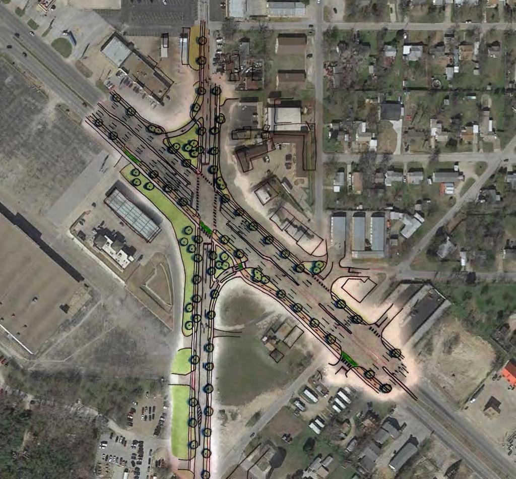

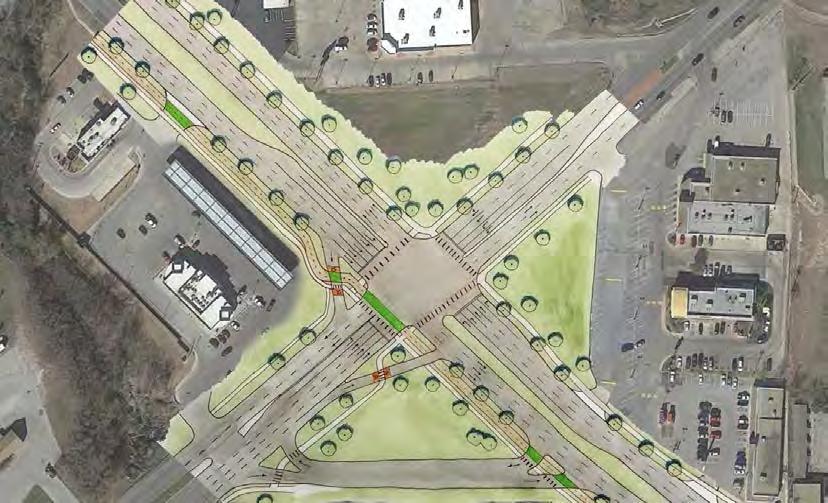
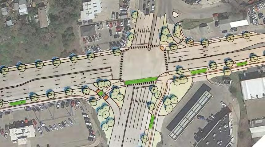
8 Conceptual Intersection Layouts DRAFT DRAFT
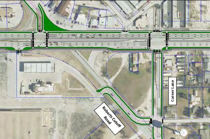
9 Conceptual Intersection Layouts DRAFT DRAFT
10 Potential Effects to Properties Along SH 199 Change to property access Change in locations of median openings Construction impacts - will suggest that TxDOT explore quarterly meetings with property owners These will be addressed by TxDOT during the preliminary engineering and environmental process

11 Potential Economic Development Nodes Conducted market assessment within trade area Reviewed projected industry and corridor trends Completed parcel-by-parcel analysis by studying zoning, land use, topography, land values, land assembly, and ownership type High nodal development potential
12 Urban Design Base Concept Parkway Concept Boulevard Concept


13 Urban Design Parkway Concept Outward Emphasis Urban Transition Development Nodes Boulevard Concept Inward Emphasis Optimize Natural Features


14 Urban Design Concept Plan Parkway Concept ROW 150 ROW Transition Zone

15 Urban Design Concept Plan Boulevard Concept ROW 120 ROW Transition Zone

16 Stakeholder and Public Involvement Stakeholder Steering Committee Meetings Stakeholder meetings with staff and elected officials Community Meeting #1 October 2016 Numerous presentations including: o Coffee and Conversation with Mayor Barnett o Fort Worth Pedestrian and Bicycle Advisory Commission o Samsom Park Annual Business Luncheon o Fort Worth City Council o Tarrant County Commissioners Court
17 Next Steps Finalize recommendations and cost estimates Prepare final report Work with TxDOT to initiate preliminary engineering and environmental process for the project
18 What Do You Think About.. Roadway Design Urban Design Economic Development Opportunities
19 Study Information and Contact Comments and/or Questions to:
20 Community Meeting No. 2 May 31, 2017
Scope of Services. River Oaks Boulevard (SH 183) Corridor Master Plan
 Corridor Master Plan") Scope of Services River Oaks Boulevard (SH 183) Corridor Master Plan PROJECT AREA The project area consists of the River Oaks Boulevard (SH 183) corridor bounded by SH 199 at the northern end and the Trinity
Scope of Services River Oaks Boulevard (SH 183) Corridor Master Plan PROJECT AREA The project area consists of the River Oaks Boulevard (SH 183) corridor bounded by SH 199 at the northern end and the Trinity
Southern Gateway Project and Public Green
 Southern Gateway Project and Public Green Transportation and Trinity River Project Committee May 23, 2016 Purpose of Presentation Provide the history and an overview of the Southern Gateway Project (SGP)
State Highway 121 Southwest Parkway. Fort Worth s Transportation Success Story in Design and Cooperation
 State Highway 121 Southwest Parkway Fort Worth s Transportation Success Story in Design and Cooperation Greater Fort Worth Association of Realtors October 24, 2007 Presented by: Dan Lamers, P.E. North
Executive Summary. NY 7 / NY 2 Corridor
 Executive Summary NY 7 / NY 2 Corridor Transportation and Land Use Study December 2005 Prepared for: Town of Colonie Capital District Transportation Committee Prepared by: Introduction: Land use decisions
This page left intentionally blank.
 July 2012 This page left intentionally blank. Table of Contents Appendix A : Project Development Checklist Appendix B: At-Grade Rail Crossings Appendix C: Maintenance and Operations Examples Appendix D:
PREPARED FOR: PLATTEVIEW ROAD CORRIDOR STUDY EXECUTIVE SUMMARY
 PREPARED FOR: PLATTEVIEW ROAD CORRIDOR STUDY EXECUTIVE SUMMARY SEPTEMBER 2016 Introduction The Platteview Road Corridor Study was led by the Metropolitan Area Planning Agency (MAPA) with assistance from
2017 General Obligation Bond
 2017 General Obligation Bond Presentation of Public and Council Projects to the Transportation & Mobility Stakeholder Committee April 13, 2017 Agenda Deferred Maintenance Project Development Process Projects
Memorandum CITY OF DALLAS
 Memorandum DATE September 23, 2016 CITY OF DALLAS TO The Honorable Members of the Transportation and Trinity River Project Committee: Lee M. Kleinman (Chair), Deputy Mayor Pro Tem Erik Wilson (Vice-Chair),
SH 199 Corridor Master Plan Volume I Final Report
 Volume I Final Report September 2017 This Page Intentionally Left Blank. ii What is NCTCOG? The North Central Texas Council of Governments is a voluntary association of cities, counties, school districts,
TIRZ 17/Redevelopment Authority Capital Improvements Plan Projects
 Gessner Widening: T-1701 What: Widen the road from a six-lane divided boulevard to an eight-lane divided boulevard street section, increase turn lanes, update traffic signal system, improve drainage by
Pine Island Road Corridor Master Plan
 RECOMMENDED DEVELOPMENT PLAN Figure 9: Del Prado Village District Conceptual Framework The Conceptual Framework (Figure 8) for development of the Pine Island Corridor is to encourage mixed-use development
Cobb County Design Guidelines Mableton Parkway & Veterans Memorial Highway Community Design Workshop January 12, 2017
 Community Design Workshop January 12, 2017 Agenda Opening Remarks / Introductions Scope of Work Existing Conditions Key Issues / Opportunities VPS Summary Draft Vision & Goal Statement Implementation Concepts
Agenda. Introductions and Overview Study Purpose Study Approach Key Analysis Components Study Context Development Activity ( )
") October 5, 2017 Agenda Introductions and Overview Study Purpose Study Approach Key Analysis Components Study Context Development Activity (2005-2017) Existing Conditions Alternatives Public Engagement
October 5, 2017 Agenda Introductions and Overview Study Purpose Study Approach Key Analysis Components Study Context Development Activity (2005-2017) Existing Conditions Alternatives Public Engagement
I-95 Interchange & Ellis Road PD&E Study
 I-95 Interchange & Ellis Road PD&E Study Brevard County, Florida Presentation to the Space Coast TPO October 14, 2010 The Project Provide a New Interchange with I-95 Using the Ellis Road Corridor, Extend
Memorandum CITY OF DALLAS. Riverfront Boulevard Design From Continental Avenue to Cadiz Street
 Memorandum DATE November 10, 2011 CITY OF DALLAS TO Trinity River Corridor Project Committee Members: Vonciel Jones Hill (Chair) Linda Koop (Vice Chair), Monica Alonzo, Scott Griggs, Angela Hunt, and Delia
Sustainable Development Call for Projects Western Infrastructure Project Submissions
 2009-2010 Sustainable Development Call for Projects Western Infrastructure Project Submissions January 20, 2010 2009-2010 SDCFP Summary of Infrastructure Funding Infrastructure Projects Number of Projects
12/9/2013. HOLLYWOOD/PINES CORRIDOR PROJECT AMPO 2013 Annual Conference October 24, Our Perspective. Broward.
 HOLLYWOOD/PINES CORRIDOR PROJECT AMPO 2013 Annual Conference October 24, 2013 Our Perspective Broward Fort Lauderdale 1 Broward Metropolitan Planning Organization Fort Lauderdale Fort Lauderdale Skyline
ITEM #8. Regional Smart Growth Program. Regional Smart Growth Program. Presentation Overview. Coast Highway Vision and Stategic Plan.
 Regional Smart Growth Program Economic Development Commission What is Smart Growth? Adopted as part of the Regional Comprehensive Plan (RCP) RCP provides vision for region based on Smart Growth and sustainability
LITTLE ELM CAPTIAL IMPROVEMENT BOND STREET PRESENTATION
 LITTLE ELM 2009-2014 CAPTIAL IMPROVEMENT BOND STREET PRESENTATION Denton Frisco Little Elm Lewisville Legacy Southlake Grapevine Addison DENTON COUNTY & LEWISVILLE LAKE MATCHING FUNDS DENTON COUNTY BOND
Cottage Grove Road Reconstruction. City of Madison Engineering
 Public Informational Meeting Cottage Grove Road Reconstruction October 8, 2015 Presentation Outline Introduction Project Purpose & Need Proposed Design Overview Environmental Concerns Pedestrian Needs
Secrest Short Cut and Monroe Expressway Small Area Plan AUGUST 29, 2018
 Secrest Short Cut and Monroe Expressway Small Area Plan AUGUST 29, 2018 Background and Process Monroe Expressway will be open by the end of 2018 Union County and Indian Trail identified a need to revisit
Gratigny Parkway East Extension Project Development & Environment (PD&E) Study
 Study") Gratigny Parkway East Extension Project Development & Environment (PD&E) Study Session 4: Presentation of Charrette Results December 8, 2010 MDX Work Program #: 92407 ETDM#: 11500 Project Location & Description
Gratigny Parkway East Extension Project Development & Environment (PD&E) Study Session 4: Presentation of Charrette Results December 8, 2010 MDX Work Program #: 92407 ETDM#: 11500 Project Location & Description
CITY OF CHARLOTTESVILLE, VIRGINIA CITY COUNCIL AGENDA
 CITY OF CHARLOTTESVILLE, VIRGINIA CITY COUNCIL AGENDA Agenda Date: December 16, 2013 Action Required: Adoption of Resolution Presenter: Staff Contacts: Title: James E. Tolbert, AICP, Director of NDS James
SUNBRIDGE PARKWAY PRELIMINARY DESIGN STUDY. Board of County Commissioners Public Hearing
 SUNBRIDGE PARKWAY PRELIMINARY DESIGN STUDY Board of County Commissioners Public Hearing March 20, 2018 Presentation Overview Study Overview Existing Conditions Project Development Plan Public Involvement
Independence Boulevard Area Plan Planning Committee Public Comment May 18, 2010
 Independence Boulevard Area Plan Planning Committee Public Comment May 18, 2010 Presentation Outline Focus on Key Recommendations within Draft Plan Plan Purpose and Development Process Draft Plan Policies
Route 1 Corridor Study
 Route 1 Corridor Study Westbrook, Connecticut A Vision for the Connecticut Shoreline Public Informational Meeting July 28, 2015 Lower Connecticut River Valley Council of Governments Fitzgerald & Halliday,
Honorable Members of the Mobility Solutions, Infrastructure and Sustainability Committee
 Memorandum DATE January 23, 2019 CITY OF DALLAS TO Honorable Members of the Mobility Solutions, Infrastructure and Sustainability Committee SUBJECT I-30 East Project Update On Monday, January 28, 2019,
I. INTRODUCTION. Project Background and Study Area
 I. INTRODUCTION Project Background and Study Area Freedom Parkway is a key east-west corridor connecting I-25 on the west to the Town of Kersey on the east, running approximately one to two miles south
9 th Street Sub Area Plan
 9 th Street Sub Area Plan In the 1990 s, when the Township prepared the last Master Plan, the 9 th Street corridor was studied as part of a larger 9 th Street Focus Area that included the West Main Street
I. DESCRIPTION OF PROPOSED ACTION... 1 A. General Description... 1 B. Historical Resume and Project Status... 2 C. Cost Estimates...
 PROJECT COMMITMENTS SUMMARY... S-1 1. Type of Action... S-1 2. Description of Action... S-1 3. Summary of Purpose and Need... S-1 4. Alternatives Considered... S-2 5. NCDOT Alternatives Carried Forward...
Chapter 2: Preliminary Analysis
 State Highway 5 Corridor Context Sensitive Master Plan ADOPTED June 17, 2014 (Resolution 2014-06-071) Chapter 2: Preliminary Analysis Before looking to the future of the State Highway 5 (SH 5) Corridor,
Por favor, levanten la mano si necesita traduccion en espanol Please raise your hand if you need Spanish translation
 FEDERAL BOULEVARD CORRIDOR WIDE STUDY PUBLIC MEETING #1 APRIL 27, 2016 Por favor, levanten la mano si necesita traduccion en espanol Please raise your hand if you need Spanish translation HDR DESIGN WORKSHOP
Reinventing Miner Avenue as a
 Reinventing Miner Avenue as a Complete Street Reinventing Miner Avenue as a Complete Street Agenda Project Overview / Introductions Previous Meeting Recap Economic Considerations Opportunities & Constraints
Citizen Information Meeting
 Prince William County Government Citizen Information Meeting Vint Hill Road Extension May 11, 2016 Benefits: Route 28 Corridor Improvement Program Estimated significant cost savings versus bidding these
The Illinois Department of Transportation and Lake County Division of Transportation. Route 173, including the Millburn Bypass
 The Illinois Department of Transportation and Lake County Division of Transportation welcome you to this Public Hearing for U.S. Route 45 from Illinois Route 132 to Illinois Route 173, including the Millburn
2040 Long Range Transportation Plan
 2040 Long Range Transportation Plan Adopted: April 15, 2013 APPENDIX D HIGHWAY NEEDS PLAN PROJECTS FREDERICKSBURG Existing and Committed Projects Fall Hill Avenue/Mary Washington Blvd. (Fredericksburg)
REGIONAL TRANSPORTATION COMMISSION OF SOUTHERN NEVADA AGENDA ITEM
 REGIONAL TRANSPORTATION COMMISSION OF SOUTHERN NEVADA AGENDA ITEM Metropolitan Planning Organization [ X ] Transit [ ] Administration and Finance [ ] SUBJECT: PROJECT SELECTION PROCESS FOR TRANSPORTATION
WHAT IS THE PURPOSE OF THE OPEN HOUSE?
 WHAT IS THE PURPOSE OF THE OPEN HOUSE? OPEN HOUSE PURPOSE The purpose of the open house is to provide an update on the study process and introduce the preliminary concept alternatives. The open house provides
University Parkway Corridor Plan. Public Workshop Sept. 18, 2017
 University Parkway Corridor Plan Public Workshop Sept. 18, 2017 AGENDA 1. Overview of Process 2. Study Area 3. Components of the Plan 4. What We Know 5. What We Have Heard 6. Tonight s Input 7. Next Steps
North Carolina Department of Transportation Project Development and Environmental Analysis Branch
 North Carolina Department of Transportation Project Development and Environmental Analysis Branch Citizens Informational Workshop I-85, from I-485 to NC 73 Mecklenburg and Cabarrus Counties October 30,
Tyvola & Archdale Transit Station Area Plan. May 15, 2008
 Tyvola & Archdale Transit Station Area Plan First Public Meeting May 15, 2008 Presentation Outline 1. Purpose and Process 2. Station Area Overview 3. Plan Recommendations Vision Land Use Transportation
Lesson 6. Corridor Planning
 Lesson 6 Corridor Planning 1 Learning Outcomes Identify land use strategies and solutions that can be incorporated into multimodal transportation corridor plans Identify land use stakeholders and describe
IOWA HIGHWAY 57 / WEST 1 ST STREET STUDY PUBLIC INFORMATIONAL MEETING APRIL 22, 2014
 IOWA HIGHWAY 57 / WEST 1 ST STREET STUDY PUBLIC INFORMATIONAL MEETING APRIL 22, 2014 INTRODUCTION The City of Cedar Falls and the Iowa Department of Transportation are conducting a Public Informational
Project Overview. Fairfax County Parkway Widening Fairfax County. Get Involved. Public Information Meeting. Contact Information
 Get Involved VDOT representatives will review and evaluate information received as a result of this meeting. Please fill out the comment sheet provided in this brochure if you have any comments or questions.
Atlanta BeltLine Corridor Environmental Study. Scoping Meeting August 2008
 Atlanta BeltLine Corridor Environmental Study Scoping Meeting August 2008 What Will We Be Discussing Today? Study Overview - How Did We Get Here? - What Is the Study About? - Who Is Involved? - Where Is
WURZBACH PARKWAY WURZBACH PARKWAY
 WURZBACH PARKWAY WURZBACH PARKWAY From Lockhill-Selma Rd to NW Military Hwy Open NW Military HouseHwy/Lockhill-Selma Open House Barshop Jewish Community Center December Barshop Jewish 14, 2017 Community
City of Dallas Complete Streets Program. SAME Infrastructure Forum February 2, 2018
 City of Dallas Complete Streets Program SAME Infrastructure Forum February 2, 2018 Complete Streets Design Manual Adopted by City Council January 27, 2016 JANUARY 27, 2016 2 What are Complete Streets?
WELCOME! 8 8:30 6: TH STREET IMPROVEMENTS. Open House. Presentation & Q&A
 WELCOME! 168 TH STREET IMPROVEMENTS 6:30 Open House 7 8 Presentation & Q&A 8 8:30 Open House WELCOME Todd Pfitzer City of Omaha Engineer Bob Stubbe City of Omaha Public Works Director Jon Meyer Project
Exhibit A. SH 161 RTC Work Program of New Projects. Collin County
 Exhibit A SH 161 RTC Work Program of New Projects Collin County 0918-24-969 N/A 0918-24-970 N/A 0918-24-973 N/A 2351-01-020 N/A 2679-03-010 N/A On Exchange Parkway from US 75 to Allen Heights On Country
Municipality of Anchorage. Community Council Survey Capital Projects Needs Ranking Survey (ALPHABETICAL) Airport Heights
 Airport Heights") ANCHORAGE PARKS & RECREATION Nichols Park Design and improve neighborhood park 2008 Challenge Grant applicant. 2008 $500K State Grant for Neighborhood Parks. Tikishla Park Lighting, paved parking, hockey
ANCHORAGE PARKS & RECREATION Nichols Park Design and improve neighborhood park 2008 Challenge Grant applicant. 2008 $500K State Grant for Neighborhood Parks. Tikishla Park Lighting, paved parking, hockey
PROJECT BACKGROUND. Preliminary Design Scope and Tasks
 PROJECT BACKGROUND Preliminary Design Scope and Tasks The purpose of this Study is the development of preliminary designs for intersection improvements for Trunk Highway (TH) 36 at the intersections of
Creating Complete Roadway Corridors:
 Creating Complete Roadway Corridors: The AASHTO Guide to Transportation Landscape Architecture and Environmental Design NCHRP Project 15-33 Status Report AASHTO Standing Committee on Design Technical Committee
Regional Mobility & the US 380 Bypass Concept. Informational Meeting February 9, 2017
 Regional Mobility & the US 380 Bypass Concept Informational Meeting February 9, 2017 Purpose and Agenda Purpose: Regional Mobility Issues, Priorities, and Pressures US 380 as a Limited Access Facility
NORTH-SOUTH CORRIDOR STUDY EXECUTIVE SUMMARY. Executive Summary
 Executive Summary Background As congestion continues to affect mobility in the region, the Ozarks Transportation Organization (OTO) is particularly concerned with traffic movement. The North-South Corridor
TORONTO COMPLETE STREETS GUIDELINES
 TORONTO COMPLETE STREETS GUIDELINES Presentation by Fiona Chapman, Manager, Pedestrian Projects Public Realm Section, Transportation Services, City of Toronto June 2017 PURPOSE OF THE PROJECT To develop
State Highway 5 Corridor Context Sensitive Master Plan
 ADOPTED June 17, 2014 (Resolution 2014-06-071) Travel Lane Travel Lane 11 11 Median 16 Min State Highway 5 Corridor Context Sensitive Master Plan 1 Prepared for: Prepared by: State Highway 5 Corridor
Alternatives Development Three conceptual alternatives were developed for the Race Road/Jessup Village Planning Study and are described below:
 Race Road/Jessup Village Planning Study (H550601) Project Newsletter Spring 2015 Project Description The Study Team, consisting of staff from Anne Arundel County (Department of Public Works and Department
BeltLine Corridor Environmental Study
 BeltLine Corridor Environmental Study Joint TAC and SAC Meeting December 8, 2008 What We Will Discuss Today Outreach and Agency Coordination Scoping Results Existing Conditions Historical and Archeological
Seneca Meadows. Block 4 Locate office, technology, and medical development adjacent to I Screen views of garage structures from I-270.
 Seneca Meadows Seneca Meadows has an industrial park in its southern end and a mixed-use employment area planned for the north end. The district benefits from extensive I-270 visibility, stream valley
Capital Projects in and near Odenton Town Center
 Capital Projects in and near Odenton Town Center Map ID Anne Arundel County Department of Public Works This project provides for the design, right of way acquisition, and construction of approximately
SUNBRIDGE PARKWAY PRELIMINARY DESIGN STUDY. November 30, 2017
 SUNBRIDGE PARKWAY PRELIMINARY DESIGN STUDY November 30, 2017 Agenda Introductions and Overview Study Purpose Study Approach Key Analysis Components Study Context Existing Conditions Corridor Constraints
Capital Projects impacting Odenton Town Center
 Capital Projects impacting Odenton Town Center 1 2 E549700 W801600/ W801602 Anne Arundel County Department of Public Works Manor View Elementary School Transmission Main - MD 32 @ Meade Phase 2 $34,399,000
Making TOD Work in the Heart of Suburban Sprawl
 Making TOD Work in the Heart of Suburban Sprawl Rocky Mountain Land Use Institute March 6, 2009 Speakers Ben Herman, FAICP, Principal Clarion Associates Darcie White, AICP, Principal Clarion Associates
SCTPO Project Summary September 2014
 A1A MULTIMODAL CORRIDOR PLANNING AND ENGINEERING ANALYSIS Florida Department of Transportation SCTPO Project Summary September 2014 PRESENTATION FOOTER Meeting Agenda What We Plan To Do Project Background
SEWRPC. Joint Meeting of the Advisory Committees on Regional Land Use Planning and Regional Transportation Planning APRIL 26, 2018
 SEWRPC Joint Meeting of the Advisory Committees on Regional Land Use Planning and Regional Transportation Planning APRIL 26, 2018 WISCONSIN DEPARTMENT OF TRANSPORTATION BRETT WALLACE, FOXCONN PROJECT DIRECTOR
4.1 Build Alternative 1 Construction Phasing
 SECTION 4 Implementation Plan This section discusses potential segmentation of the build alternatives into multiple projects for implementation of improvements to the NSH from Rabbit Creek Road to 36th
ARGENTA TRAIL (CSAH 28/63) REALIGNMENT SOUTH PROJECT (CP 63-25)
 REALIGNMENT SOUTH PROJECT (CP 63-25)") ARGENTA TRAIL (CSAH 28/63) REALIGNMENT SOUTH PROJECT (CP 63-25) Preliminary Design Report February 2015 Prepared For: City of Inver Grove Heights Dakota County Prepared By: Kimley-Horn and Associates,
ARGENTA TRAIL (CSAH 28/63) REALIGNMENT SOUTH PROJECT (CP 63-25) Preliminary Design Report February 2015 Prepared For: City of Inver Grove Heights Dakota County Prepared By: Kimley-Horn and Associates,
INDEPENDENCE BOULEVARD AREA PLAN. June 24, 2008
 INDEPENDENCE BOULEVARD AREA PLAN Public Meeting #1 June 24, 2008 Tonight s Agenda Introduction Welcome and Ground Rules Overview Presentation Purpose of the Plan What Brings Us Here? A Tour of the Corridor
SECTION 4(f) DE MINIMIS DOCUMENTATION
 DE MINIMIS DOCUMENTATION") SECTION 4(f) DE MINIMIS DOCUMENTATION Illinois Route 60/83 IL 176 to the intersection of IL 60 (Townline Road) Lake County P-91-084-07 Mundelein Park and Recreation District Project Limit SECTION 4(f)
SECTION 4(f) DE MINIMIS DOCUMENTATION Illinois Route 60/83 IL 176 to the intersection of IL 60 (Townline Road) Lake County P-91-084-07 Mundelein Park and Recreation District Project Limit SECTION 4(f)
Tyvola & Archdale Transit Station Area Plan. June 5, 2008
 Tyvola & Archdale Transit Station Area Plan Second Public Meeting June 5, 2008 Presentation Outline 1. Purpose and Process 2. Station Area Overview 3. Plan Recommendations 4. Comments Received and Proposed
Shift Rapid Transit Public Participation Meeting May 3, 2017
 Shift Rapid Transit Public Participation Meeting May 3, 2017 Shift Rapid Transit Initiative Largest infrastructure project in the city s history. Rapid Transit initiative will transform London s public
Date: April 10, 2017 City Council Work Session April 24, 2017: Status Report on the Comprehensive Plan Update and Transportation Master Plan
 AGENDA REPORT To: From: By: Honorable Mayor and City Council Members Warren Hutmacher, City Manager Sharon Ebert, Director Community Development Date: April 10, 2017 Agenda: City Council Work Session April
Rezoning Transportation Analysis Petition Number: General Location Identifier:
 From: Kelsie Anderson, PE Kelsie.Anderson@charlottenc.gov 704-432-5492 Staff Reviewer: Kory Hedrick, PE, PMP Khedrick@charlottenc.gov 704-432-6511 CDOT s review of this rezoning petition is intended to
Borderland Expressway Coalition Status Report Camino Real RMA Board Meeting. El Paso, TX April 11, 2018
 Borderland Expressway Coalition Status Report Camino Real RMA Board Meeting El Paso, TX April 11, 2018 Coalition Key Stakeholders Texas Department of Transportation New Mexico Department of Transportation
Commissioners Road West Realignment Environmental Assessment
 City of London Commissioners Road West Realignment Environmental Assessment Public Information Centre No. 1 March 30, 2017 Welcome to the Public Information Centre This first Public Information Centre
Community Sensitive Design: (Context Sensitive Design)
") What is? Community Sensitive Design: (Context Sensitive Design) The process by which urban design, land-use planning and aesthetic enhancements are applied to a project to make it an integral part of the
What is? Community Sensitive Design: (Context Sensitive Design) The process by which urban design, land-use planning and aesthetic enhancements are applied to a project to make it an integral part of the
IH35 Corridor Plan Amendment to the Comprehensive Plan
 IH35 Corridor Plan Amendment to the Comprehensive Plan Background The corridor plan for the IH35 corridor is an amendment to the Burleson comprehensive plan. Generally, the purpose of a corridor plan is
Implementation Guide Comprehensive Plan City of Allen
 Implementation Guide 2030 Comprehensive Plan City of Allen DRAFT 2015 Implementation Guide Allen 2030 Comprehensive Plan INTRODUCTION The Comprehensive Plan serves as a guide for the growth and development
Description of Preferred Alternative
 Chapter 2 Description of Preferred Alternative 2.1 Introduction This chapter of the programmatic Sammamish Town Center Sub-area Plan Final EIS provides a more detailed description of the Preferred Alternative
Mary Hills Nature Area. Roadway Lighting. The Minneapolis Clinic of Neurology Courage Kenny Rehabilitation Institute
 PUBLIC REALM IMPROVEMENTS Mary Hills Nature Area Enhanced Programming Glenview Terrace Valley View Roadway Lighting Enhanced Streetscape Trail Lighting / Roadway Lighting Wayfinding Public Art The Minneapolis
PLANNING COORDINATING COMMITTEE
 PLANNING COORDINATING COMMITTEE Fall Meeting/Luncheon Welcome! October 16, 2009 PLANNING COORDINATING COMMITTEE Fall Meeting/Luncheon WELCOME! WELCOME! October 16, 2009 October 16, 2009 Agenda I. Lunch/Socialize
Richmond Road Complete Street Meeting #1, April 25, 2016
 Richmond Road Complete Street Meeting #1, April 25, 2016 Agenda Overview Richmond Road Complete Street Other Ongoing Studies Discussion Map buses/day removed from Sir John A. Macdonald Parkway Confederation
Q:%4~ Memorandum CITY OF DALLAS
 Memorandum DATE December 10, 2010 CITY OF DALLAS TO Members of the Transportation and Environment Committee: Linda Koop (Chair), Sheflie Kadane (Vice Chair), Pauline Medrano, Vonciel Jones Hill, Jerry
Harlem Avenue Corridor Plan: Corridor Planning Across Municipal Boundaries
 Harlem Avenue Corridor Plan: Corridor Planning Across Municipal Boundaries Heather Tabbert, Manager, Local Planning and Programs Division Regional Transportation Authority (RTA) Jen McNeil Dhadwal, Principal
Citizen Comment Staff Response Staff Recommended Revision Planning Committee
 Citizen Comment Staff Response Staff Recommended Revision Planning Committee Area No. 1: Owner desires retail land uses. Area No. 1a: Owner of two small parcels adjacent to Area No. 1 desires retail land
TRANSPORTATION ELEMENT GOALS, OBJECTIVES, AND POLICIES
 TRANSPORTATION ELEMENT GOALS, OBJECTIVES, AND POLICIES GOAL 2 The City shall provide a safe, convenient, effective, and energy efficient multimodal transportation system which is coordinated with the Future
Welcome to the. Open House
 Welcome to the 5th Street to Kinsman Road Open House November 14 5:30 7:00 p.m. Please sign in Project Overview In December 2016, City Council adopted SW 5th Street as the preferred alignment to connect
Infrastructure Engineering Planning Construction Suite 300 Minneapolis, MN Tel: Fax:
 Infrastructure Engineering Planning Construction 701 Xenia Avenue outh uite 300 Minneapolis, MN 55416 Tel: 763-541-4800 Fax: 763-541-1700 Memorandum To: Minnehaha Creek Watershed District Board From: Tony
Welcome to the LYNX Blue Line Extension Transit Station Area Plans Public Workshop No. 3. Presentation will begin at 6:00 P.M.
 Welcome to the LYNX Blue Line Extension Transit Station Area Plans Public Workshop No. 3 Presentation will begin at 6:00 P.M. Meeting Agenda Blue Line Extension (BLE) Project Update LYNX Blue Line Extension
Fairfax County Parkway (Route 286) Widening Project
 Widening Project") Fairfax County Parkway (Route 286) Widening Project Route 29 (Lee Highway) to Route 123 (Ox Road) State Project No. 0286-029-259, P101; UPC 107937 Fairfax Station HOA Meeting January 30, 2018 7:00 to 9:00
Fairfax County Parkway (Route 286) Widening Project Route 29 (Lee Highway) to Route 123 (Ox Road) State Project No. 0286-029-259, P101; UPC 107937 Fairfax Station HOA Meeting January 30, 2018 7:00 to 9:00
14 October 10, 2012 Public Hearing APPLICANT: MPB, INC
 14 October 10, 2012 Public Hearing APPLICANT: MPB, INC PROPERTY OWNER: MUNDEN & ASSOCIATES, LP STAFF PLANNER: Karen Prochilo REQUEST: Conditional Change of Zoning (AG-1 & AG-2 to Conditional O-2) ADDRESS
Comprehensive Plan Advisory Panel Meeting #3
 Comprehensive Plan Advisory Panel Meeting #3 November 7, 2016 Agenda 1. September 19 th Meeting Notes 2. Summary of Focus Areas Charrette 3. Heart of the City Focus Area a. HOC2/Station Areas Concept &
Public input has been an important part of the plan development process.
 Lakewood s Comprehensive Plan recognizes that transportation helps shape the community, and that the way the community provides for the safe and efficient movement of people affects the character of the
TxDOT Experience with Long-Term Private Maintenance Agreements
 TxDOT Experience with Long-Term Private Maintenance Agreements June 2, 2015 Beau B. Buchanan, P.E. Project Manager TxDOT South Central Strategic Projects Office San Antonio, Texas Maintenance Agreements
Economic Development & Housing Council Committee Comprehensive Plan Update September 20, 2005
 1 Economic Development & Housing Council Committee Comprehensive Plan Update September 20, 2005 Purpose To update the Committee on the ForwardDallas! Plan, including: Status Anticipated Products Public
Places29: List of Implementation Projects
 Important Points to Keep in Mind When Using This List Places29: List of s Each of the projects in this List represents an action needed to implement the Places29 Master Plan. The projects are grouped first
The transportation system in a community is an
 7 TRANSPORTATION The transportation system in a community is an important factor contributing to the quality of life of the residents. Without a sound transportation system to bring both goods and patrons
Section4 Design Vision & Implementation Plan
 Section4 Design Vision & Implementation Plan W Woodschurch Rd 4.1 Design Focus Areas The Framework Plan is simply the starting point for directing the design and implementation of a wide range of transportation
Carson Street Streetscape Improvements. Request for Proposals
 Carson Street Streetscape Improvements Request for Proposals Complete Design Services for a Landscape/Streetscape Plan for Carson Street (Pioneer Boulevard to Norwalk Boulevard) Submittal Deadline: October
Corridor Enhancements
 Corridor Enhancements Safety is MoDOT s first priority in widening and rebuilding I-70 across the state of Missouri. MoDOT also understands that the interstate - and its interchanges and overpasses - are