Land Use. Chapter 8: Introduction. Land Use Vision. Section I: Current Land Use 8-1
|
|
|
- Meagan Cross
- 6 years ago
- Views:
Transcription

1 Introduction Land use is the defining element of the comprehensive plan. It will serve as a framework for decision makers, guiding future growth and development in the Town of Oconto Falls. This chapter describes existing land use patterns in the Town and sets forth a plan for future land use consistent with the community s visions. It will guide the Town Board, Plan Commission, property owners, developers, and others in decisions regarding the category, location, and density of future development. The land use chapter is divided into two parts. Section I: Current focuses on existing land uses. It provides an inventory of current land uses, identifies land use trends, and describes the tools currently used to guide development. Section II: Future comprises the 20-year land use plan for the Town of Oconto Falls and presents the tools that may be useful in implementing the plan. Implementation of the comprehensive plan will result from the incremental decisions made by elected and appointed officials during the review and approval of zoning changes, certified survey maps, subdivision plats, site plans, and the like. Through these decisions, the Town may realize its goals as they relate to the physical growth and development of the community. Successful implementation will require a sustained effort by the public and private sectors to utilize this chapter, and the Future map contained within it, as the essential decisionmaking guide for land use in the Town of Oconto Falls. Vision The Town of Oconto Falls will strive to preserve the places and land uses most important to our community while allowing for well-planned residential and commercial development designed in harmony with the natural landscape so as to ensure a safe, beautiful, and thriving community for future generations. Section I: Current The purpose of the current land use section of the chapter is to describe the existing land base of the community (i.e., residential, commercial, agricultural, open space, etc.). It also includes an inventory of the ordinances policies, and other land use tools utilized to guide development. 8-1
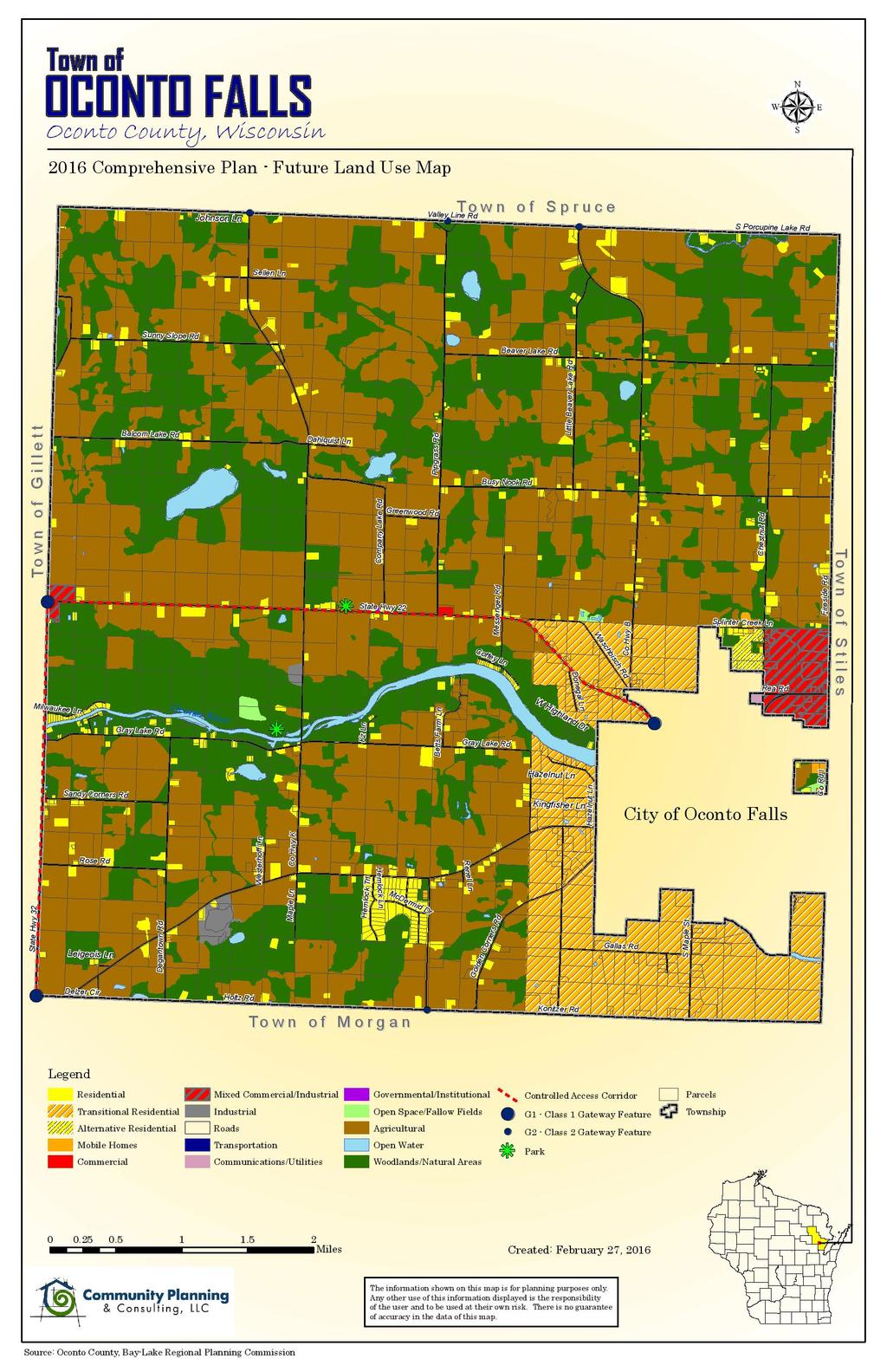
2 Current Inventory The inventory of current land uses presented in Table 8.1 is based upon the Current map appearing on page 8-3. The map was developed using available GIS/mapping data provided by Oconto County, Bay Lake Regional Planning Commission, and the Wisconsin Department of Transportation, among others. The purpose of the map is to provide a reasonably accurate snap shot of the community, as it exists today, and to serve as a foundation for the Future map appearing on page Residential & Population Density Table 8.1: Current land Uses in the Town of Oconto Falls, 2015 Total Acreage Percent of Total Acreage Agricultural 11, % Commercial % Communications & Utilities % Governmental & Institutional % Industrial % Mobile Homes % Open Space & Fallow Fields % Parks & Recreation % Residential % Roads % Transportation % Woodlands & Natural Areas 7, % Total 20, % Source: Town of Oconto Falls Current map, With a total of 488 housing units on square miles of land, the net residential density in the town is roughly 15 units per square mile. The population density is 39 persons per square mile based upon an estimated 2015 population of 1,275 people. Trends & Supply The Town s land base is comprised primarily of agricultural lands, woodlands, the Oconto River valley, and sparsely scattered single-family housing. Due to the preponderance of wetland and floodplains, the vast majority of future development will occur on lands currently classified as Agricultural or Woodlands / Open Space. The available supply of developable land is sufficient to meet future land use goals. Current Regulations A variety of mechanisms are currently utilized in the Town to guide development and resource preservation, including zoning and subdivision ordinances. Additional tools that may be adopted are presented later in this chapter. 8-2
3 8-3
4 Zoning Regulations The purpose of a zoning ordinance is to identify the permitted and conditional uses allowed on parcel of land within designated zoning districts. Zoning ordinances may also regulate lot size, road frontage, density, and the location, height, and size of structures, among others. Oconto County administers and enforces zoning regulations with the Town of Oconto Falls. Oconto County utilizes a conventional (or Euclidean) zoning regime that is based upon the designation of zoning districts within which permitted and conditional uses are permissible. Alternative zoning models are presented later in this chapter. Table 7.2 lists the zoning districts within the Town and provides a brief description of district regulations. Table 8.2: Zoning Districts and District Regulations in the Town of Oconto Falls District Permitted Uses Conditional Uses Minimum Lot Size A Agricultural Multiple (consult ordinance). Multiple (consult ordinance). 10 acres. F Forest GC General Commercial Agricultural production (crops, livestock, or both); forestry, forestry services, logging, portable sawmills, and portable planning mills; hunting, trapping, and game production; municipal parks; singlefamily; manufactured home; mobile home; firewood processing facility (less than 20 cord per year). Community buildings; community garages and storage facilities; kennels; landfills; permanent sawmills; shooting ranges; utility towers; firearms sales and/or service; firewood processing facility (20 or more cord per year); private parks. 10 acres Multiple (consult ordinance). Multiple (consult ordinance). Determined by Zoning Administrator based upon site plan. I Industrial Multiple (consult ordinance). Multiple (consult ordinance). Determined by Zoning Administrator based upon site plan. RR Rural Residential R-1 Residential Single-Family Agricultural production (crops, livestock, or both); temporary auctions; manufactured homes; single-family homes; animal shelters, barns, and sheds; accessory structures; utilities. Cemeteries; churches; community buildings; municipal parks; manufactured home; single-family; schools. Addition, expansions of, or conditional operations of pre-existing uses; Conditional uses in A and F districts; mobile home; two-family home; bed & breakfast establishments; daycare centers, more than 8 children; utility towers; conditional uses in R-1 district; firework sales; firearm sales and/or service. Bed & breakfast establishments; duplexes; daycare centers, more than 8 children; utility towers; firework sales; firearm sales and/or service; private parks. 2 acres Sewered: 10,000 sq ft Unsewered: 20,000 sq ft Note: The permitted uses, conditional uses, and minimum lot sizes listed in this table are for planning purposes only. This table contains only those Oconto County zoning classifications that exist within the Town of Oconto Falls. Landowners should consult the Oconto County Zoning Ordinance for formal requirements and specific regulations related to each district. Source: Oconto County Zoning Ordinance. Oconto County also administers Floodplain and Nonmetallic Mining ordinances within the Town. 8-4
5 Land Division & Subdivision Regulations Unlike zoning, which regulates the use of land, subdivision regulations govern the manner in which land transitions from one use to another (typically from agricultural or open space to residential). A subdivision ordinance provides the procedures and standards for dividing a large parcel into smaller parcels for sale or development. Subdivision regulations require that developers meet certain conditions in order to record a certified survey map or plat. As with zoning, subdivision regulations are an effective tool through which local government can implement a comprehensive plan. The Town of Oconto Falls administers and enforces its own subdivision ordinance; though it does so in consultation with Oconto County. Section II: Future This section of the chapter will serve as the primary guidance tool for the Town in implementing the plan. Like a blueprint for a building renovation, the comprehensive plan serves as a guide to construct, or design, the future Town of Oconto Falls. The section is segmented into two broad focus areas:! Community Design Considerations. The underlying issues guiding future development in the community. Presented and discussed in earlier chapters, these are the primary areas of focus for the comprehensive plan.! Community Design Approaches. The broad strategies and specific policies (including ordinances) used to guide future development in the Town and to address community design considerations. Community Design Considerations Community design is an important component of planning and plays a significant role in determining quality of life in and preserving the character of a community. Elements of community design may include the culture and history of a community along with architectural standards, open space and natural resource protection, transportation and access, and recreation, among others. Ordinances provide the primary means by which local governments implement community design requirements. Property Rights The issue of private property rights versus community need underlies every comprehensive planning effort. Property rights are ingrained in American jurisprudence. Those rights have been respected, to the greatest extent feasible, throughout the planning effort. This chapter describes and illustrates proposed development patterns for the Town of Oconto Falls. It will be used by local officials, landowners, developers, and others to make informed land use and development decisions. Should a landowner disagree with the Future map, or any other aspect of this plan, he/she has the right to petition the Town for an amendment to the 8-5
6 document. All amendments will occur through a public process, defined by state law, and will include a public hearing. The process of amending the comprehensive plan is described in Chapter 10: Implementation. Community Character Character is defined differently for each community but includes a blend of natural, built, visual, and cultural characteristics. It represents the sum of the attributes and assets that make a community unique, and that establish a sense of place for its residents. In the Town of Oconto Falls, community character means:! An economically viable agricultural sector for the long-term.! Scattered single-family residential development.! Preserved forests and open space.! High-quality surface waters and preserved riparian corridors.! A healthy and sustainable landscape.! A safe and friendly community. Community Design Approaches Community design approaches represent the guiding principles of the comprehensive plan and are integral to the desired future for Oconto Falls. Their incorporation into the application review and approval process will ensure that new development blends harmoniously with the existing built and natural environment, while providing for land use patterns that promote a high quality of living. Conservation Design The landscape of the Town offers an array of natural features that defines its character. Preserving rural character is a primary goal of the comprehensive plan. To accommodate future growth while maintaining the integrity of the natural environment, the Town of Oconto Falls will encourage conservation design approaches to new development. Conservation design will allow the community to:! Protect rural character by maintaining (and restoring) natural areas, woodlands, scenic views, open undeveloped areas and farm fields, while addressing desired residential and commercial development needs.! Lower the cost of development by reducing the amount of impervious surface, minimizing stormwater management expenditures, shortening permit review times, and addressing the desire for community parks and open space.! Create natural corridors of green space between developments that can be utilized by wildlife and have the potential to be used as trail or walkway areas to improve connections between development nodes. 8-6
7 ! Preserve agricultural lands to ensure that they remain an economically viable component of the landscape.! The principles of conservation design can be applied to rural and urbanized environments and may be incorporated into residential, commercial, and industrial, development as well as parks and municipal properties. Future Map The future land use map is the visual representation of the visions, goals, objectives, and policies presented in the comprehensive plan. It is the principal tool used by the Town to guide development. As per Wisconsin s Comprehensive Planning Law, decisions related to development and governed by the zoning and subdivision ordinances must be made in a manner consistent with the map. Relationship to Zoning Map The future land use map is not a zoning map. It is a compilation of the elements comprising the earlier chapters of the comprehensive plan including agricultural and natural resources, economic development, housing, and transportation. It reflects the desired 20-year future for the Town. Table 8.3 presents information differentiating the future land use and zoning maps. Table 8.3: Comparison of Future Map and Zoning Map Future Map Zoning Map Comprehensive Plan Requirement Yes No Wisconsin Statutes (chapters, sections) (2)(h) 59.69(5); 60.61(4); 62.23(7) Local Government Adopts By ordinance as part of comprehensive plan By ordinance as part of zoning ordinance Parcel-based No No Displays General land use categories Zoning districts Use Visual guide for the community Designate height, bulk, and use of land Source: University of Wisconsin Stevens Point Center for Education, 2004 How will the Future Map be Used? The future land use map will guide the Town Board and Commission during the review of requested zoning changes, land division and subdivision applications, and other local land-use decisions in accordance with the Planning Law. Landowners and developers will consult the plan when making development decisions, and should be confident that an application for development that is consistent with the comprehensive plan will be approved. It is important to note that a plan is not a static document. It must evolve to reflect current conditions. If not regularly reviewed and amended, it will become less effective over time. Applications for rezoning and development that are inconsistent with the plan must be given due consideration, not rejected out of hand. In some situations, it may be desirable to amend the plan (and maps) to accommodate a compatible, but previously unplanned use. Likewise, a change in county or 8-7
8 regional policy, technological advances, the economy, or the natural environment may affect the plan. Changes to the plan (including plan maps) must be considered in the context of all nine required plan elements, and reflect the visions, goals, objectives, and policies expressed within the document. If an amendment is to be approved, the process must include a formal public hearing and distribution per the requirements of the Planning Law (see Chapter 10: Implementation for amendment process). Amendments must be reviewed by the Plan Commission and approved by the Town Board before the plan may be revised. Description of Future s This section provides a brief description of the proposed land uses presented on the future land use map. Table 8.4 presents land use projections for the Town of Oconto Falls through the year Alternative Residential Areas well suited to alternative residential living options. Such housing may include: senior living, small unit multi-family (duplexes, quadplexes), live-work units, etc. Community Park / Preserved Open Space Community parks are generally five or more acres in size and are intended to serve the recreational needs of the greater community. They may be active, passive, or a combination thereof. Amenities within an active park may include athletic fields, play equipment, tennis courts, basketball courts, band shells, pavilions, restrooms, and the like. Passive parks provide opportunities for rest and reflection and interaction with nature. They may include nature trails, hiking and skiing trails, and picnic areas, and tend to include restorative and educational elements such as prairie restoration and reforestation. Gateway Features Gateway features are intended to inform visitors that they have entered the Town of Oconto Falls. Main entry points (STH 22 and STH 32) will utilize larger features, with smaller versions associated with County highways and appropriate Town roads. The most important element of a gateway system is consistency in design, materials, and landscaping. Limited Access Corridor STH 22 and STH 32 have been designated as a limited access corridor by the WDOT. As a result, development along these corridors should utilize side streets and crossroads for access as opposed to providing additional driveways directly onto the state highway. 8-8
9 Mixed Commercial / Industrial Areas identified as suitable for a mixture of compatible commercial and industrial land uses on shared or adjoining parcels. The Town will look to utilize the Light Industrial (LI) and multiple commercial districts in the county zoning ordinance within these mixed commercial/industrial areas. Riparian Corridor The boundaries of the proposed riparian corridor would extend 100 from the high-water mark on each side of the selected stream segments (encompassing County shoreland setbacks). The purposes of the parkways will be to provide vegetated buffers between streams and adjacent land uses so as to improve water quality, preserve wildlife habitat, and mitigate flooding. Riparian corridors would not be imposed upon existing land uses, but implemented upon review of applications for rezones and land divisions. Transitional Residential The purpose of the Transitional Residential (TR) is to create an intermediary buffer between the more densely developed areas in the southeast corner of the Town and the less densely developed agricultural areas throughout the remainder of the community. The TR allows for market-based residential development consistent with the goal of preserving rural character and functional open space. All minor land divisions (through certified survey maps) and subdivision plats within the TR would follow the principals of conservation design. The TR land use category may be implemented utilizing the zoning districts available in the county zoning ordinance. The Town will work with the county to develop other means of implementing the TR land use category as necessary Projections Table 8.4: Projections for the Town of Oconto Falls, Acreage by Year Current Agricultural 11,431 11,179 10,927 10,676 10,426 Commercial Industrial Mixed Commercial / Industrial Residential (all categories) 918 1,356 1,794 2,232 2,670 Source: Town of Oconto Falls Future Map. Goals, Objectives, and Policies The goals, objectives, and policies related to land use are presented in Chapter 10: Implementation. 8-9
10 8-10
Chapter 10 IMPLEMENTATION RECOMMENDATIONS
 Chapter 10 IMPLEMENTATION RECOMMENDATIONS The recommended land use plan presented in the previous chapter provides a design for the attainment of the urban and rural development and open space preservation
THREE-STEP DESIGN PROCESS FOR OPEN SPACE SUBDIVISIONS
 00216106.DOC NMA/RRK 1/30/14 THREE-STEP DESIGN PROCESS FOR OPEN SPACE SUBDIVISIONS Open space subdivisions, sometimes called cluster developments, maintain a significant portion of a development site in
Rural Land Use Designations Kittitas County December 6, 2007 Draft
 KITTITAS COUNTY COMMUNITY DEVELOPMENT SERVICES 411 N. Ruby St., Suite 2, Ellensburg, WA 98926 CDS@CO.KITTITAS.WA.US Office (509) 962-7506 Fax (509) 962-7682 Rural Land Use Designations Kittitas County
CHAPTER 4 FUTURE LAND USE AND URBAN SERVICES DISTRICTS
 CHAPTER 4 FUTURE LAND USE AND URBAN SERVICES DISTRICTS Introduction This chapter discusses how Benzie County should grow and change in the future. A community can grow and change in many different ways.
Conservation Development
 Acknowledgements RIDEM: Scott Millar Anthony Lachowicz-Planning and Zoning Consultant Director of Planning 1 : a creative land use technique that allows a community to guide growth to the most appropriate
Implementation Vision
 Introduction The implementation chapter is the how to portion of the plan. It describes the actions necessary to realize the visions presented in this document through the goals, objectives, and policies
Gloucester County s Comprehensive Plan. The Community Connection
 Gloucester County s Comprehensive Plan The Community Connection Current Comp Plan Adopted in 1991 with a 20 year planning horizon Updated in 1995 with Part V- Implementation Recommendations and Appendix
Exhibit A. 8:9 Scuffletown Rural Conservation District
 Exhibit A 8:9 Scuffletown Rural Conservation District 8:9.1 Intent and Purpose The Scuffletown Rural Conservation (SRC) District is intended to provide for residential development that supports the development
AWH REPORT OF THE PLANNING AND DEVELOPMENT DEPARTMENT FOR APPLICATION FOR REZONING ORDINANCE TO PLANNED UNIT DEVELOPMENT
 AWH REPORT OF THE PLANNING AND DEVELOPMENT DEPARTMENT FOR APPLICATION FOR REZONING ORDINANCE TO PLANNED UNIT DEVELOPMENT MAY 8, 2014 The Planning and Development Department hereby forwards to the Planning
This page intentionally blank.
 This page intentionally blank. Parks, Recreation, and Open Space Chapter Relationship to Vision Vision Parks, Recreation and Open Space Chapter Concepts County Government. County government that is accountable
AREASTRUCTURE PLAN AMENDMENT COCHRANE NORTH
 AREASTRUCTURE PLAN AMENDMENT COCHRANE NORTH In order to implement the vision outlined in the Conceptual Scheme, the following three amendments to the Cochrane North ASP are proposed: 1. Allow commercial
EXECUTIVE SUMMARY DRAFT CHAPTER 1 INTRODUCTION EXECUTIVE SUMMARY
 CHAPTER 1 EXECUTIVE SUMMARY INTRODUCTION Through the joint efforts of the City of Tulsa planning staff and the Land Services division of Indian Nations Council of Governments (INCOG), the Berryhill Land
Town of Rico Three Mile Plan for Annexation
 Town of Rico Three Mile Plan for Annexation 10.20.2010 Adopted by Resolution 2010-2 Produced with funding support from the Colorado Department of Local Affairs 2 Content Guide Introduction. 3 Annexation
A Growing Community Rural Settlement Areas
 Town of Huntsville Official Plan Review - POLICY BACKGROUND PAPER A Growing Community Rural Settlement Areas BACKGROUND: In addition to the fully municipally-serviced Urban Settlement Area and the Hidden
Town of Peru Comprehensive Plan Executive Summary
 Town of Peru Comprehensive Plan Executive Communities that plan grow by choice, not by chance. A plan makes growth thoughtful, understandable, and predictable. A plan shows that a community is managing
Chapter 6: Community Character
 Chapter 6: Community Character The term "community character" covers a broad spectrum of concerns. First and foremost, community character is a visual concept. In Long Grove, however, community character
Regional Context Statement
 Regional Context Statement REGIONAL CONTEXT STATEMENT 3. REGIONAL CONTEXT STATEMENT In 1995, the Provincial Government passed into law the Growth Strategies Act. The purpose of this provincial initiative
St. Croix County Shoreland Overlay Zoning Districts. Public Hearing Community Development Committee December 19, 2013
 St. Croix County Shoreland Overlay Zoning Districts Public Hearing Community Development Committee December 19, 2013 Timeline CDC Review October 17 Public Information Meeting October 29 (6:00-8:00 pm)
3.10 LAND USE SETTING PROJECT SITE EXISTING LAND USE DESIGNATIONS AND ZONING. General Plan Land Use Designations.
 This section of the Draft EIR addresses the existing land uses on and adjacent to the project site and discusses the potential impacts of the proposed project on existing land uses. Key issues addressed
Major Subdivision Sketch Plan Checklist
 This checklist provides specific requirements that are apart of the Sketch process. The entire process is described by the Huntersville Subdivision Review Process which details all the submittal and resubmittal
UNIVERSITY OF MICHIGAN:
 Chapter Eight UNIVERSITY OF MICHIGAN: North Campus I. Introduction The University of Michigan currently owns approximately 800 acres of land in the northeast section of Ann Arbor. North Campus refers to
9.0 EXISTING LAND USE
 9.0 EXISTING LAND USE Table of Contents Introduction...117 Existing Land Use and Zoning...117 Existing Land Use Breakdown...117 Town of Nekimi Existing Land Use Map...119 Town of Nekimi Zoning Map...121
SECTION UNIFIED DEVELOPMENT ORDINANCE SECTION Part 1 Ordinance. ARTICLE 1 Zoning Districts
 SECTION 1-100 UNIFIED DEVELOPMENT ORDINANCE SECTION 1-300 Part 1 Ordinance SECTION 1-100. Introduction. ARTICLE 1 Zoning Districts Crystal Lake strives to maintain a balance of various land uses for a
E. RURAL COMMERCIAL/INDUSTRIAL PARK MODEL
 E. RURAL COMMERCIAL/INDUSTRIAL PARK MODEL 1. PURPOSE The purpose of the Rural Commerce/Industrial Park Model is to provide parameters within which a grouping of business buildings with parking, loading
Procedures IV. V. Rural Road Design Option
 i IV. Procedures A. All applicants required to prepare a Conservation Design Subdivision shall provide the Planning Board with a conceptual conventional subdivision design as well as a proposed layout
Planning & Zoning Commission Staff Report
 Planning & Zoning Commission Staff Report Meeting Date: May 26, 2015 Drafted by: Katherine Harrison-Rogers CASE # Z2886 PROJECT NAME: APPLICANT/ REPRESENTATIVE: Shawna Runyan PROPERTY OWNER: 1840 (previously
2.0 AREA PLANS. Lakeside Business District. Lakeside Business District Land Use Categories:
 Lakeside Business District Lakeside Business District Land Use Categories: Campus Commercial Campus Commercial means a mixture of uses which includes corporate offices, office parks, hotels, commercial,
Draft Stillwater 2030 Comprehensive Plan- Goals and Policies
 Draft Stillwater 2030 Comprehensive Plan- Goals and Policies Instructions- Review each goal and policy and discuss with group any changes, deletions for additions to the list using your groups pen. Keep
Dwelling Units Max 12 dwelling units per acre/min 8 dwelling units per acre. Development Mix 80% non residential/20% residential
 13. OSTEEN LOCAL PLAN Background: The Osteen Local Plan area is located in southwest Volusia County along the SR 415 corridor between Lemon Bluff Road and Acorn Lake Road and includes 3,990 acres. The
Minnesota Department of Natural Resource - Natural Resource Guidance Checklist Conserving Natural Resources through Density Bonuses
 Minnesota Department of Natural Resource - Natural Resource Guidance Checklist Conserving Natural Resources through Density Bonuses NRDB Why Use Density Bonuses & This Checklist Local units of government
Chesapeake Bay Critical Area Conservation Plan
 The Maryland-National Capital Park and Planning Commission Prince George s County Planning Department Development Review Division 301-952-3530 Note: Staff reports can be accessed at www.mncppc.org/pgco/planning/plan.htm.
CHAPTER 22 Rural Open Space Community Developments
 CHAPTER 22 Rural Open Space Community Developments Section 22.1 Description and Purpose The intent of this Chapter is to offer property owners an alternative to traditional zoning requirements for rural
Chapter 13: Implementation Plan
 Implementation A. Introduction The Implementation Plan, in table form on the following pages, provides a summary of all the Action Items recommended in Chapters 2 through 12. The table also indicates which
CHAPTER 7: VISION AND ACTION STATEMENTS. Noble 2025 Vision Statement
 CHAPTER 7: VISION AND ACTION STATEMENTS This chapter presents the vision, policy and action statements that transform the comprehensive planning study, an analysis of Noble s past, future trends and community
Planning for and Managing Open Space and Natural Areas
 Planning for and Managing Open Space and Natural Areas Increasingly, development proposals in Delaware include large amounts of open space and natural areas. While open space is important as a community
Authority of the General Plan
 Authority of the General Plan This La Habra Heights General Plan will serve as the blueprint for future planning and development in the City. This General Plan describes the City s vision for the future
Table IX-1 LAND USES IN WASHINGTON COUNTY: 2006
 #128550 v1 - WASH CO CP TBL I-1 2006 LU NMA/RLR 12/21/07 Table I-1 LAND USES IN WASHINGTON COUNTY: 2006 Note: This table, and the accompanying map, is more general than the land use inventory conducted
CHAPTER 4 - LAND USE CLASSIFICATIONS
 CHAPTER 4 - LAND USE CLASSIFICATIONS Four new land use classification categories are established in the Gualala Town Plan: Gualala Village Mixed Use; Gualala Highway Mixed Use; Gualala Planned Development
Purpose of the Master Plan
 Purpose of the Master Plan 4 Master Plan Purpose The Master Plan is a policy framework for decisions that affect the physical, social and economic environment of the Town. The Parker 2035: Master Plan
ARTICLE VI AGRICULTURAL PROTECTION DISTRICT
 A. Findings and Purpose ARTICLE VI AGRICULTURAL PROTECTION DISTRICT The Town of Northumberland finds that the protection of agriculture is essential to the implementation of the goals and objectives ofthe
6 PORT SYDNEY SETTLEMENT AREA
 Section 6 Port Sydney Page 61 6 PORT SYDNEY SETTLEMENT AREA 6.1 Basis and Principles Village of Port Sydney Waterfront Community Existing Services 6.1.1 Port Sydney is an historic settlement that has developed
PUD GUIDE FOR THE RED MOUNTAIN RANCH PLANNED UNIT DEVELOPMENT
 PUD GUIDE FOR THE RED MOUNTAIN RANCH PLANNED UNIT DEVELOPMENT Exhibit B to the Annexation and Development Agreement October 15, 2018 *Notes in red are intended for Town of Eagle review purposes and are
City of Chickasaw Land Use Comprehensive Plan 2030 Chapter5-Draft(2)Public review_
Public review_") Land Use Land Use refers to the activity or development characteristics of a given parcel of land. The Land Use Plan presented in the following pages, represents the City of Chickasaw s official position
Land Use Land Use refers to the activity or development characteristics of a given parcel of land. The Land Use Plan presented in the following pages, represents the City of Chickasaw s official position
Courthouse Planning Area
 Courthouse Planning Area Current Reality The Courthouse Planning Area is the characterized by expansive suburbanscale residential areas as well as the community resource planned area of athletic, educational,
Shoreland Zoning. Kay Lutze Shoreland Zoning Policy Coordinator
 Shoreland Zoning Kay Lutze Shoreland Zoning Policy Coordinator Kay.Lutze@wisconsin.gov Purposes of shoreland zoning include Prevent and control water pollution Protect spawning grounds, fish and aquatic
Town of Portola Valley General Plan. Nathhorst Triangle Area Plan
 Town of Portola Valley General Plan Amended December 10, 1997 Table of Contents Introduction... 1 Planning Area... 1 Objectives... 2 Principles... 2 Standards... 4 Description... 4 Community Commercial...
Rural Conservation. Rural Conservation. Moving Forward ~ Planning Ahead. Introduction
 Introduction Minnehaha County expresses at least two very different styles of character. The City of Sioux Falls provides a strong urban atmosphere because of its size and regional status, and the unincorporated
General Location Annex, Rezone & Preliminary Plat Lansdowne Addition, Unit Three
 NEWFOUNDLAND I-5 Agricultural District Subject Site SUNDANCE ANDERSON Single Family Residential CHRISTY PUD Agricultural District Highway Business General Location Annex, Rezone & Preliminary Plat Lansdowne
Town of Washington Master Plan & Regulatory Audit: Interim Results
 Town of Washington Master Plan & Regulatory Audit: Interim Results May 20, 2008 Presented by: 30 Bank Street Lebanon, NH 03766 www.uvlsrpc.org Introduction & Purpose Compare the Master Plan to the regulations
Goal 1: To Encourage the Orderly, Harmonious and Judicious Use of University Resources in the Development of University Land.
 2.0 Future Land Use Goal 1: To Encourage the Orderly, Harmonious and Judicious Use of University Resources in the Development of University Land. Objective 1.1: Make available future building sites that
Regulation Changes for Open Space and Similar Uses
 Regulation Changes for Open Space and Similar Uses What is the Project? This project is an analysis of the Zoning Ordinance relating to public lands and open space regulations. The proposed text amendments
APPENDIX D: PARKS AND RECREATION ACTION PLAN
 APPENDIX D: PARKS AND RECREATION ACTION PLAN Goals The following goals are specific to the development, maintenance, and operation of the existing parks in the Township, as well as the acquisition and
TOWN OF SPRINGFIELD, NEW HAMPSHIRE
 TOWN OF SPRINGFIELD, NEW HAMPSHIRE NATURAL RESOURCES INVENTORY EXECUTIVE SUMMARY March 2008 Prepared by: Watershed to Wildlife, Inc. Natural Resource Consultants 42 Mill Street, Suite 3 Littleton, NH 03561
Draft CHAPTER TWO THREE LAND USE PLAN
 CHAPTER TWO THREE LAND USE PLAN LAND USE PLAN The basic intent of the comprehensive planning process is to provide a well-founded and coordinated decision-making framework to guide both public and private
This chapter describes the purpose of the Plan, introduces how the Plan is organized and provides contextual background for the Plan.
 Chapter 1: INTRODUCTION Purpose of a Comprehensive Plan The 2040 Comprehensive Plan establishes Medina s vision as a community and sets goals and objectives which guide future decisions and policies. The
Purpose of the Master Plan
 Purpose of the Master Plan 4 Master Plan Purpose The Master Plan is a policy framework for decisions that affect the physical, social and economic environment of the Town. The Parker 2035: Master Plan
Mendota Heights 2040 Comprehensive Plan Draft Vers
 4 Parks and Trails The City of Mendota Heights boasts a variety of recreational and open space opportunities. Few cities can claim access to regional trails, riverside and lakeside parks, scenic bluffs
PARTF Scoring System for Grants
 PARTF Scoring System for Grants The members of the N.C. Parks and Recreation Authority use the PARTF scoring system as one of several tools to select grant recipients. Please provide all of the information
SEWRPC OUTDOOR RECREATION AND OPEN SPACE PLANNING OBJECTIVES, PRINCIPLES, AND STANDARDS
 SEWRPC OUTDOOR RECREATION AND OPEN SPACE PLANNING OBJECTIVES, S, AND STANDARDS Introduction The Southeastern Wisconsin Regional Planning Commission (SEWRPC), as part of the regional park and open space
Green Infrastructure Policies and Ordinances
 Green Infrastructure Policies and Ordinances October 23, 2013 By Karen Firehock, Green Infrastructure Center 2013 Georgia Urban Forest Council s 23 rd Annual Conference The mission of the nonprofit Green
ORDINANCE WHEREAS, this Ordinance is consistent with the City of Winter Garden Comprehensive Plan; and
 ORDINANCE 17-06 AN ORDINANCE OF THE CITY COMMISSION OF THE CITY OF WINTER GARDEN, FLORIDA, CREATING ARTICLE XIV OF CHAPTER 118 OF THE CITY OF WINTER GARDEN CODE OF ORDINANCES PROVIDING FOR THE EAST PLANT
O Dell Parkway PUD Association, Inc. PO Box 1335
 CITY OF SOUTH BURLINGTON DEVELOPMENT REVIEW BOARD SD_14_06_F+MDevelopment_25BaconSt_sketch SKETCH PLAN REVIEW #SD-14-06 O DELL PARKWAY PUD DEPARTMENT OF PLANNING & ZONING Report preparation date: April
TERRESTRIAL NATURAL HERITAGE SYSTEM STRATEGY APPENDIX F: MODEL POLICIES FOR THE IMPLEMENTATION OF THE TARGET TERRESTRIAL NATURAL HERITAGE SYSTEM
 TERRESTRIAL NATURAL HERITAGE SYSTEM STRATEGY APPENDIX F: MODEL POLICIES FOR THE IMPLEMENTATION OF THE TARGET TERRESTRIAL NATURAL HERITAGE SYSTEM C H A P T E R 1 M O D E L P O L I C I E S F O R I M P L
2 PLANNING AREA DESCRIPTION
 2 PLANNING AREA DESCRIPTION 2.1 LOCATION Hecker Pass is located within the City of Gilroy near the western city limit. Figure 2-1 illustrates the regional location of the Hecker Pass Area. Figure 2-1:
HAZARD MITIGATION GOALS AND OBJECTIVES
 SEWRPC Community Assistance Planning Report No. 282, 2nd Edition CITY OF MILWAUKEE ALL HAZARDS MITIGATION PLAN UPDATE Chapter IV HAZARD MITIGATION GOALS AND OBJECTIVES [NOTE: Throughout this plan update
Chapter 5: Natural Resources and Environment
 NATURAL RESOURCES AND ENVIRONMENT 5-1 5 Chapter 5: Natural Resources and Environment BACKGROUND AND INTENT Urban expansion represents the greatest risk for the future degradation of existing natural areas,
LAND USE ELEMENT. Purpose. General Goals & Policies
 LAND USE ELEMENT Purpose This Land Use Element contains the goals and policies necessary to support the City s responsibility for managing land resources and guiding development through implementing regulations,
LAND USE OVERVIEW WHAT YOU WILL FIND IN THIS CHAPTER
 LAND USE WHAT YOU WILL FIND IN THIS CHAPTER Information about the City s expected population and employment growth. Description and capacity of existing and future land use designations. Policies that
Innovative Land Use Techniques
 Innovative Land Use Techniques A Handbook for Sustainable Development Eric Williams, Assistant Administrator, NHDES Carolyn Russell, Principal Planner, NHDES Cliff Sinnott, Executive Director, RPC Jill
Community Development Department Planning Division 1600 First Street + P.O. Box 660 Napa, CA (707)
") Community Development Department Planning Division 1600 First Street + P.O. Box 660 Napa, CA 94559-0660 (707) 257-9530 PLANNING COMMISSION STAFFREPORT December 4, 2014 AGENDA ITEM 8.A. 14-0138; ALTAMURA
Community Development Department Planning Division 1600 First Street + P.O. Box 660 Napa, CA 94559-0660 (707) 257-9530 PLANNING COMMISSION STAFFREPORT December 4, 2014 AGENDA ITEM 8.A. 14-0138; ALTAMURA
COUNTY COUNCIL OF PRINCE GEORGE'S COUNTY, MARYLAND SITTING AS THE DISTRICT COUNCIL 2010 Legislative Session. Council Members Dernoga and Olson
 DR- COUNTY COUNCIL OF PRINCE GEORGE'S COUNTY, MARYLAND SITTING AS THE DISTRICT COUNCIL 00 Legislative Session Bill No. CB--00 Chapter No. Proposed and Presented by Introduced by Co-Sponsors The Chairman
2016 Comprehensive Plan Amendments C OMPREHENSIVE P LAN T EXT AND M AP A MENDMENT
 2016 Comprehensive Plan Amendments T EXT A MENDMENTS D ISTILLERIES IN R URAL P OLICIES #844110 LID POLICIES #844112 M AP A MENDMENTS B ETHEL S CHOOL D ISTRICT #844237 P ARKS AND R ECREATION #844305 C OMPREHENSIVE
OPEN SPACE CHAPTER 7: OVERVIEW. Preserve open space to protect natural resources, enhance character and provide passive recreation opportunities
 CHAPTER 7: OPEN SPACE OVERVIEW Ridgefield has made tremendous progress permanently preserving areas of town as open space. Open space preservation can serve many important purposes, including: protect
COMMUNITY DESIGN. GOAL: Create livable and attractive communities. Intent
 COMMUNITY DESIGN Intent An attractive, well-designed County will attract quality development, instill civic pride, improve the visual character of the community, and create a strong, positive image for
DEVELOPMENT FRAMEWORK POST 2030 LAND USE PLAN INTRODUCTION
 INTRODUCTION Oak Grove s Comprehensive Plan identifies a future Metropolitan Urban Service Area (MUSA). The Metropolitan Council does not anticipate extending utilities to this area prior to 2030. The
3.0 PROJECT DESCRIPTION
 3.0 PROJECT DESCRIPTION 3.1 BACKGROUND Under California law (Government Code Section 65300 et seq.), every city and county is required to have a general plan. The general plan is to be comprehensive and
Conservation Corridor Planning and Green Infrastructure Themes
 Conservation Corridor Planning and Green Infrastructure Themes Prepared by the Green Infrastructure Center Inc. and the Northern Virginia Regional Commission February 22, 2011 Brief Overview Project Background
CHAPTER 1: INTRODUCTION
 CHAPTER 1: INTRODUCTION MAP OF OUTAGAMIE COUNTY, WI N 1 = 6 miles INTRODUCTION The Town and Village of Black Creek are located in central Outagamie County, Wisconsin. The Village is located in the north
YONGE STEELES CORRIDOR SECONDARY PLAN. Young + Wright / IBI Group Architects Dillon Consulting Ltd. GHK International (Canada) Ltd.
 Ltd.") PART A: PREAMBLE 1.0 PURPOSE The purpose of this Secondary Plan is to provide a development framework for intensification of the Yonge/ Steeles corridor including the north side of Steeles Avenue West
PART A: PREAMBLE 1.0 PURPOSE The purpose of this Secondary Plan is to provide a development framework for intensification of the Yonge/ Steeles corridor including the north side of Steeles Avenue West
12 February 9, 2011 Public Hearing APPLICANT: WILDLIFE RESPONSE, INC.
 12 February 9, 2011 Public Hearing APPLICANT: WILDLIFE RESPONSE, INC. PROPERTY OWNER: CITY OF VIRGINIA BEACH REQUEST: Conditional Use Permit (Wildlife Rehabilitation Center) STAFF PLANNER: Karen Prochilo
ARTICLE IV: DEVELOPMENT STANDARDS 404 MASTER PLANNING
 IV 13 404 MASTER PLANNING Master Planning through the Site Analysis (Master Planning Site Analysis) or Planned Development (Master Planning Planned Development) is provided to encourage development which
-MENDOCINO COUNTY PLANNING AND BUILDING SERVICES- DIVISION II OF TITLE 20--COASTAL ZONING CODE
 CHAPTER 20.504 VISUAL RESOURCE AND SPECIAL TREATMENT AREAS Sec. 20.504.005 Applicability. Sec. 20.504.010 Purpose. Sec. 20.504.015 Highly Scenic Areas. Sec. 20.504.020 Special Communities and Neighborhoods.
A citizen s guide to the. Comprehensive Plan. City of Lakeville, Minnesota 1
 A citizen s guide to the Comprehensive Plan 2008 City of Lakeville, Minnesota 1 Introduction The City of Lakeville completed an update of its Comprehensive Plan in 2008. A comprehensive plan is a tool
BROOKHILL NEIGHBORHOOD MODEL ZONING MAP AMENDMENT PREFACE TO APPLICATION
 BROOKHILL NEIGHBORHOOD MODEL ZONING MAP AMENDMENT PREFACE TO APPLICATION June 15, 2015 Revised: August 1, 2016 I. VISION Brookhill is a proposed community based upon the principles of Albemarle County
Improve Neighborhood Design and Reduce Non Point Source Water Pollution
 HOW TO Planning Guide Improve Neighborhood Design and Reduce Non Point Source Water Pollution This document was funded by a grant from the New Hampshire Coastal Program with funding from the National Oceanic
WORK SESSION STAFF REPORT Work Session Item No. 2. Michael Grochala, Community Development Director
 WORK SESSION STAFF REPORT Work Session Item No. 2 WS Item 2 Date: March, 2018 To: From: Re: City Council Michael Grochala, Community Development Director 200 Comprehensive Plan Mixed Use Districts Background
COMMUNITY ENVIRONMENTAL MANAGEMENT
 COMMUNITY ENVIRONMENTAL MANAGEMENT CEM HANDBOOK FOR COMMUNITY CONSERVATION PLANNING ----- Draft ----- Prepared by the CENTER FOR COMMUNITY ENVIRONMENTAL MANAGEMENT in association with the NEW YORK STATE
D1 September 11, 2013 Public Hearing APPLICANT:
 D1 September 11, 2013 Public Hearing APPLICANT: BEACH MUNICIPAL FEDERAL CREDIT UNION PROPERTY OWNER: SISTERS II, LLC STAFF PLANNER: Karen Prochilo REQUEST: Conditional Change of Zoning (AG-2 Agriculture
Riparian Buffer on the Bushkill Creek. Policies
 Riparian Buffer on the Bushkill Creek Riparian buffers provide numerous benefits to landowners and the community by protecting groundwater recharge areas, providing flood control, providing stormwater
Catawba Area Plan Advisory Group
 Catawba Area Plan Advisory Group Meeting #3 Natural Environment, Part I September 23, 2008 Advisory Group Meeting #3 Welcome and Introductions Review Handouts Vision Statement GDP - Environment Draft Vision
PLANNED UNIT DEVELOPMENT & SUBDIVISION STAFF REPORT Date: May 18, 2017
 & PUD-0000102-2017 PLANNED UNIT DEVELOPMENT & SUBDIVISION STAFF REPORT Date: May 18, 2017 NAME SUBDIVISION NAME Dauphin Creek Estates Subdivision Dauphin Creek Estates Subdivision LOCATION CITY COUNCIL
Oakland County s Green Infrastructure Vision. L. Brooks Patterson Oakland County Executive
 Oakland County s Green Infrastructure Vision L. Brooks Patterson Oakland County Executive Southeast Michigan 20 miles northwest of Detroit Consists of 910 square miles Population of 1.2 million More than
Town of Amherst Comprehensive Plan: Land Use Element Page Source: Town of Amherst and Portage County Planning and Zoning Department
 CHAPTER 8 Land Use Element 66.1001(2(h Wis. Stat.: Land-use element. A compilation of objectives, policies, goals, maps and programs to guide the future development and redevelopment of public and private
I. STAFF POLICY RECOMMENDATIONS. The following RMP policy strategies are proposed by staff in support of a Scenic Resource Protection Program:
 Policy Consideration: Scenic Resource Protection Program Status: For Consideration by the Highlands Council at September 14, 2006 Work session Date: September 12, 2006 I. STAFF POLICY RECOMMENDATIONS The
Chapter IV: Development Pattern
 Chapter IV: Development Pattern Introduction The 2002 Prince George s County Approved General Plan designates three growth policy tiers Developed, Developing, and Rural as well as three center designations
STREAM BUFFERS
 88-415 STREAM BUFFERS 88-415-01 PURPOSE In the Kansas City region and throughout the nation, vegetated stream buffers have been clearly shown to protect stream stability and related infrastructure, improve
3 Vision and Goals. Vision and Goals. Blueprint for Bloomsburg. Vision. Town of Bloomsburg Comprehensive Plan,
 Vision and Goals 3 Vision and Goals Citizens of the Town of Bloomsburg clearly value their natural and cultural heritage, the walkable, mixed use pattern of downtown, the access to education, and the community
City of Missoula and Missoula County Open Space Planning Open House
 City of Missoula and Missoula County Open Space Planning Open House FEBRUARY 6, 2018 The following slides contain the display board content from the open house. Please use boards to answer questions in
Zoning Design Standards. Low Impact Development Code Update Thurston County Planning Commission March 2, 2016
 Zoning Design Standards Low Impact Development Code Update Thurston County Planning Commission March 2, 2016 Background Zoning regulations include limitations on the size and location of structures within
Glenborough at Easton Land Use Master Plan
 Land Use Framework November 30, 2007 2.0 LAND USE FRAME- WORK 2.1 LAND USE HISTORY and Setting Glenborough at Easton is located on property that was used for mining in the 19th and 20th centuries and rocket