Horizon 2035 Land Use and Transportation Element
|
|
|
- Louise Davis
- 6 years ago
- Views:
Transcription


1 CITY OF SUNNYVALE Horizon 2035 Land Use and Transportation Element City Council Study Session March 7, 2017
2 Overview General Plan Context Mixed Use Villages Transportation Mode & Parking
3 General Plan Policy Structure GOALS Policies o Actions
4 Horizon 2035 Land Use Plan


5 Possible Changes to the Draft LUTE to Respond to Input
6 MIXED USE VILLAGES
7 Mixed Use Villages Villages - Locations Features Shared Parking Green Space/Public Gathering Walking & Bike Paths Restaurants & Entertainment Housing or Office
8 All Mixed Use Areas (existing)

9 Corridor Mixed Use

10 Corridor Mixed Use Cherry Orchard

11 Corridor Mixed Use Cherry Orchard


12 Sunnyvale Corridor Mixed Use Naya & PAMF 1095 W El Camino Real Pastoria/El Camino Real

13 Transit Mixed Use

14 Transit Mixed Use Solstice, Sunnyvale

15 Transit Mixed Use Loft House, Sunnyvale

16 Transit Mixed Use San Antonio, Mt. View
17 1 2 Village Mixed Use Areas (existing) 7 6
18 Village Goal Goal E: Creation, Preservation, and Enhancement of Village Centers and Neighborhood Facilities That Are Compatible with Residential Neighborhoods
19 Village Vision Provide distinctive gathering places accessible to residential neighborhoods and access to nearby services. Each area offers variety of dwelling types areas to meet and gather with others Designed for easy navigation On Foot & By Bicycle Transit within walking range of homes, businesses, and services.
20 Villages Part of a Complete Community Mixed-use development transforming older shopping centers and office areas into new Village Centers to provide close-in services and residential diversity in existing residential areas (to be managed through the preparation of precise plans or site specific plans).
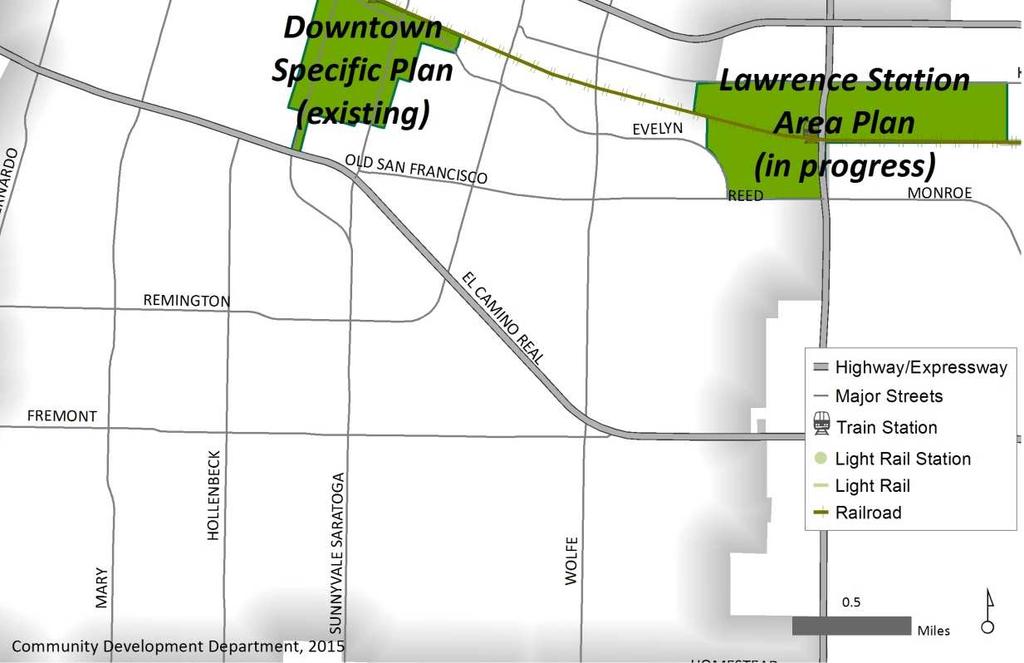
21 Village POLICY 2: Minimize regional sprawl by endorsing strategically placed development density in Sunnyvale and by utilizing a regional approach to providing and preserving open space for the broader community. Action 1: Promote transit-oriented and mixeduse development near transit centers such as Lawrence Station, Downtown, and El Camino Real and in neighborhood villages.

22 Village Mixed Use
23 Live Oak, California Existing conditions

24 Live Oak, California Public street improvements: wider sidewalks, crosswalks, medians, new signals, street trees, street lamps
25 Live Oak, California New mixed-use infill on the corner

26 Live Oak, California Infill on all corners, increased pedestrian activity


27 Village Mixed Use Bressi Ranch Village Center Carlsbad, CA Willow Glen Town Square


28 Village Mixed Use Cherry Creek, Denver CO

29 Village Mixed Use Los Altos Gardens, Los Altos, CA

30 Village Mixed Use Petrini Place, San Francisco, CA


31 Village Mixed Use Via: Tasman & Fair Oaks, Sunnyvale
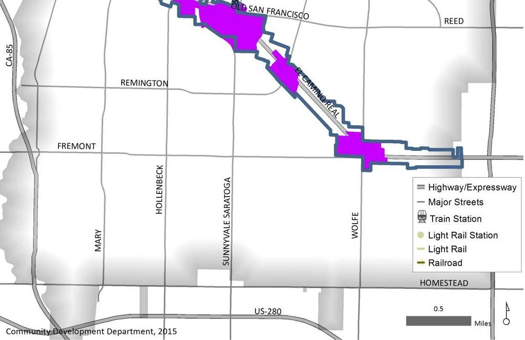
32 Existing Mixed Use Residential allowed in all zoning districts (except C-4) Subject to Approval of Use Permit Public Outreach required Mixed Use on El Camino Real since El Camino Real Charles Avenue Center Cherry Orchard Cherry Glen Las Palmas/Courtyard


33 1 2 Village Mixed Use Areas
34 Policy 53 Action 2: Develop an area plan for each Village Center to assist in achieving desired objectives and preserving or enhancing surrounding neighborhood values. LUTE Policy Area Plan Village

35 Village 1 Tasman/Fair Oaks a. b. Zoning: C-2/PD 5 stories 35% lot coverage Existing Conditions a. 3.2 acres Recreation & Printer b. 6.4 acres VILLAGE
 2 Gas Stations c. 0.4 acres (SFPUC) GREENBELT")
36 Village 2 Lakewood a. Zoning: C-1/PD 2 stories 35% lot coverage c. Existing Conditions b. b. a. 4.4 Acres Shopping Center b. 1.2 acres (2 owners) 2 Gas Stations c. 0.4 acres (SFPUC) GREENBELT
 Shopping Center b. 0.")
37 Village 3 Duane Zoning: C-1/PD & PF 2 stories 35% lot coverage b. a. Existing Conditions a. 3.9 acres (2 owners) Shopping Center b. 0.8 acres FUTURE PARK
 Independent Retail Gas Station")
38 Village 4 Maude a. b. Zoning: C-1/PD 2 stories 35% lot coverage Existing Conditions a. 4.4 acres (2-3 owners) Shopping Center Gas Station b. 4.2 acres (12 owners) Independent Retail Gas Station

39 Village 5 Old San Francisco Zoning: C-1/PD 2 stories 35% lot coverage a. b. Existing Conditions c. a. 6.6 acres Shopping Center Gas Station b. 0.7 acres Shopping Center c. 0.9 acres Shopping Center
 Shopping Center Gas Station b. 7.")
40 Village 6 Sunnyvale-Saratoga Fremont HS Zoning: C-1/PD 2 stories 35% lot coverage a. b. Existing Conditions a. 2.7 acres (2 owners) Shopping Center Gas Station b. 7.8 acres (3 owners) Shopping Center Gas Station Vacant Land
41 a. b. Village 7 a-b Fremont & Mary Zoning: C-1/PD 2 stories 35% lot coverage Existing Conditions a. 6.1 acres (2 owners) Shopping Center Gas Station b. 7.5 acres Shopping Center

42 d. c. Village 7 c-d Fremont & Mary Zoning: O/PD 2 stories 40% lot coverage Existing Conditions c. 6.1 acres Medical Offices d. 7.4 acres (3 owners) General Office Restaurant

43 Transportation Mode & Parking

44 Transportation Mode & Parking Policies Integrated Land Use and Transportation Walkable and Bike Friendly Complete Streets / Multi-modal Regional Transportation Systems Plan for People Not Cars
45 Transportation Introduction The transportation policies guide how the roadways and streets will function and how space on the roadways will be utilized by multiple modes of transportation, with attention to the transit, pedestrian, and bicycle networks. The policies create incentives for these modes of transportation and disincentives for driving, while recognizing that driving will remain a significant transportation mode in Sunnyvale.
46 Driving vs Other Modes The policies create incentives for these modes of transportation, and disincentives for driving, while recognizeing that driving will remain a significant transportation mode in Sunnyvale, and offer options for car-free or car-light living The policies create incentives for these modes of transportation, recognize that driving will remain a significant transportation mode in Sunnyvale, and offer options for car-free or carlight living.

47 Parking Policy 19: Establish Reduced parking for mixed use** Policy 24: reduce single-occupant trips and trip length Policy 27: Parking is the temporary storage of transportation vehicles** Policy 28: Prioritize street space allocated for transportation uses over parking** ** Adopted Policy


48 POLICY 31: Move progressively toward eliminating direct and hidden subsidies of motor vehicle parking and driving Action 1: Pursue opportunities for user fees such as paid parking permits at workplaces, and paid parking places for on-street parking in transit rich residential neighborhoods, and promote corporate parking cash-out programs FUTURE STUDIES could explore: Unbundle parking cost from rent/ownership Paid parking permits at workplaces Employer-paid cash out for non-sov commuters Residential Parking Permits

49 POLICY 31: Move toward eliminating direct and hidden subsidies of parking and driving Action 2: Manage City-provided public parking though pricing FUTURE STUDIES could explore: Metered Parking in focused areas Offer discounts on meters for residents, small cars and low-emissions vehicles


50 Traffic Calming POLICY 34: Support neighborhood traffic calming and parking policies that protect internal residential areas from citywide and regional traffic, consistent with engineering criteria, operating parameters, and resident preferences FUTURE STUDIES could explore: for select neighborhoods Residential Area Parking Permits/Restrictions** Traffic Calming devices/features**
51 Environmentally Friendly POLICY 25: Among motorized vehicles, give priority in all services such as carpools to low emission, zero emission, or environmentally friendly vehicles in providing parking and planning for lane priority and other operations. POLICY 25: Provide parking and lane priority to environmentally friendly motorized vehicles (e.g. carpools, low emission, zero emission).
52 Environmentally Friendly POLICY 33: Prioritize transportation subsidies and project financing over time to the most environmentally friendly modes and services. Support bicycling through planning, engineering, education, encouragement, and enforcement. Action 1: Maintain and implement a citywide bicycle plan to maximize the provision of safe and efficient bicycle and pedestrian facilities throughout Sunnyvale.**
53 Multimodal Efficiency POLICY 32: Require roadway and signal improvements for development projects to improve multimodal transportation system efficiency within the planning area.
54 Undivided Community POLICY 41: Ensure that the movement of cars, trucks and transit vehicles, bicycles, and pedestrians of all ages and abilities does not divide the community. City streets are public spaces and an integral part of the community fabric.
55 Questions & Comments
CHAPTER 7: Transportation, Mobility and Circulation
 AGLE AREA COMMUNITY Plan CHAPTER 7 CHAPTER 7: Transportation, Mobility and Circulation Transportation, Mobility and Circulation The purpose of the Transportation, Mobility and Circulation Chapter is to
Implementation Guide Comprehensive Plan City of Allen
 Implementation Guide 2030 Comprehensive Plan City of Allen DRAFT 2015 Implementation Guide Allen 2030 Comprehensive Plan INTRODUCTION The Comprehensive Plan serves as a guide for the growth and development
ITEM #8. Regional Smart Growth Program. Regional Smart Growth Program. Presentation Overview. Coast Highway Vision and Stategic Plan.
 Regional Smart Growth Program Economic Development Commission What is Smart Growth? Adopted as part of the Regional Comprehensive Plan (RCP) RCP provides vision for region based on Smart Growth and sustainability
Chapter 4. Linking Land Use with Transportation. Chapter 4
 Chapter 4 Linking Land Use with Transportation Chapter 4 59 Chapter 4 Linking Land Use with Transportation Community Design and Transportation Program Introduction Since the 1950s, the predominant development
III. Design Principles
 III. Design Principles The design of Bay Meadows Phase II has been guided by a series of Urban Design Principles. These principles, informed by consultant site analysis, City staff recommendations, and
Proposed Comprehensive Plan Strategies DRAFT for discussion June 28, 2017
 Proposed Comprehensive Plan Strategies DRAFT for discussion June 28, 2017 Land Use Rural Areas Refine the Farm and Forest area (FF) Update FF boundaries to account for existing lots less than five acres
Introduction. Chapter 1. Purpose of the Comprehensive Plan Plan Organization Planning Process & Community Input 1-1
 Chapter 1 Introduction Lakewood 2025: Moving Forward Together Purpose of the Comprehensive Plan Plan Organization Planning Process & Community Input 1-1 Purpose of the Comprehensive Plan The Comprehensive
Northwest commuter rail station US 36 BRT. Westminster Station
 Northwest commuter rail station Westminster Station US 36 BRT Westminster Center US 36 & Church Ranch Broomfield Flatiron/96 th St. US 36 & McCaslin Table Mesa Boulder Junction 13-month effort that will
Coast Highway Oceanside, California
 Coast Highway Oceanside, California Coast Highway Plan Zones What We ve Heard - Walkable/Bikeable Community (Senior and Child Friendly) -Wider Sidewalks -Street Trees -Traffic Calming -Bike Lanes -Paseos
CHAPTER 1. Ms. Guajardo s Class - Central Elementary CH 1 1
 INTRODUCTION CHAPTER 1 Ms. Guajardo s Class - Central Elementary CH 1 1 1.1 SETTING South Centre City is a linear corridor south of Downtown Escondido paralleling Centre City Parkway and South Escondido
Town Center (part of the Comprehensive Plan)
") Town Center (part of the Comprehensive Plan) Mercer Island Town Center Looking North (2014) In 1994, a year-long process culminated in a set of design guidelines and code requirements for the Town Center
Town Center (part of the Comprehensive Plan) Mercer Island Town Center Looking North (2014) In 1994, a year-long process culminated in a set of design guidelines and code requirements for the Town Center
The transportation system in a community is an
 7 TRANSPORTATION The transportation system in a community is an important factor contributing to the quality of life of the residents. Without a sound transportation system to bring both goods and patrons
Sahuarita District & Phase 1 Master Plan. Town Council December 11, 2017
 Sahuarita District & Phase 1 Master Plan Town Council December 11, 2017 Visioning Study Visioning Process Advisory Group Meetings Community Questionnaire Town Center Case Studies Community Analysis The
Denver Moves: Transit Task Force
 Insert transit picture Denver Moves: Transit Task Force Meeting #8 October 5, 2017 1. Welcome & Introductions Opening remarks and housekeeping Task Force and audience introductions Upcoming events and
 Community Workshop #2 December 4, 2014 Team Tonight s Agenda 6:00 pm Welcome! 6:05 pm The Future of Downtown Tustin Ideas, Strategies and Recommendations 6:35 pm Questions and Comments 6:50 pm Open
Public input has been an important part of the plan development process.
 Lakewood s Comprehensive Plan recognizes that transportation helps shape the community, and that the way the community provides for the safe and efficient movement of people affects the character of the
DRAFT Land Use Chapter
 Stevens Creek Urban Village DRAFT 1 18 17 Land Use Chapter INTRODUCTION This Land Use Chapter describes how the Stevens Creek Urban Village will accommodate the growth that is planned for it in the Envision
C. Westerly Creek Village & The Montview Corridor
 C. Westerly Creek Village & The VISION Community Vision When the goals of the city are achieved Westerly Creek Village, a distinctive community defined by Montview Boulevard and Westerly Creek, is a strong
Blueprint Denver A BLUEPRINT FOR AN INCLUSIVE CITY. Executive Summary
 Blueprint Denver A BLUEPRINT FOR AN INCLUSIVE CITY Executive Summary PUBLIC REVIEW DRAFT 2 1/7/2019 DENVERIGHT BLUEPRINTDENVER Blueprint Denver: A Blueprint for an Inclusive City An Equitable City Planning
Subregion 4 Central Avenue-Metro Blue Line Corridor Transit-Oriented Development (TOD) Implementation Project. Community Meeting April 27, 2011
 Implementation Project. Community Meeting April 27, 2011") Subregion 4 Central Avenue-Metro Blue Line Corridor Transit-Oriented Development (TOD) Implementation Project Community Meeting April 27, 2011 Overview Introduction to Subregion 4 TOD Implementation Program
Subregion 4 Central Avenue-Metro Blue Line Corridor Transit-Oriented Development (TOD) Implementation Project Community Meeting April 27, 2011 Overview Introduction to Subregion 4 TOD Implementation Program
CHAPTER 3 LAND USE AND TRANSPORTATION
 SUNNYVALE GENERAL PLAN CHAPTER 3 LAND USE AND TRANSPORTATION Contents Chapter Lead-in... 5 [For information only, not to be included once adopted into the General Plan]... 5 Sunnyvale A Complete Community...
2.0 THE PLATINUM TRIANGLE VISION
 2.0 THE PLATINUM TRIANGLE VISION The envisions an exciting future for the area surrounding Angel Stadium of Anaheim, the Honda Center and The Grove of Anaheim. 2.1 Planning Principles In order to further
Blueprint Denver Task Force Meeting #16 February 22, 2018
 Blueprint Denver Task Force Meeting #16 February 22, 2018 Agenda Welcome, Meeting Overview and Process Update Change Categories Small Group Recommendations Discussions: Land Use and Built Form General
Redevelopment of Downtown
 June 25, 2013 Redevelopment of Downtown Old US 41 Corridor Redevelopment Masterplan Downtown Color Palette Southern Shores and Beaches Sherwin Williams Downtown Vision Rendering Old Florida Design EcoDistricts
Figure BE-4: Urban Form - Corridors. Urban Form and Land Use. Page BE-24 Redwood City General Plan S A N F R A N C I S C O B A Y.
 and Land Use Bird Island S A N F R A N C I S C O B A Y Foster City Bair Island Belmont Greco Island San Carlos Veterans Blvd. El Camino Real Broadway Middleeld Rd. Menlo Park Woodside Rd. Features El Camino
Status Report: MD 355 Project
 Status Report: MD 355 Project OCTOBER 2006 M-NCPPC MONTGOMERY COUNTY PLANNING DEPARTMENT Summary of Community Comments, and break to the Results of the MD 355 Participation Session Brookside Gardens -
, C-MS I June 3, 2016 $1500 pd chk #216918
 , C-MS-8 LOTS 21 THROUGH 40, INCLUSIVE, BLOCK 299 CLEMENTS ADDITION TO THE CITY OF DENVER SOUTHEAST QUARTER OF SECTION 34, TOWNSHIP 3 SOUTH, RANGE 68 WEST, SIXTH PRINCIPAL MERIDIAN, CITY
SECTION TWO: Urban Design Concepts
 SECTION TWO: Urban Design Concepts The Gardnerville Plan for Prosperity shapes economic opportunities presented by regional growth. The Urban Design Concepts provide policies and concepts for land use,
Unhealthy City Costs of Inactivity & Poor Diet
 Healthy City Unhealthy City Costs of Inactivity & Poor Diet Physical cost Overweight and obesity Premature illness (diabetes, cancer, heart disease, stroke) Disability Death Economic cost State: $41.2
Rezoning Issues Setting a Foundation for Zoning Decisions
 Rezoning Issues Setting a Foundation for Zoning Decisions City Council Workshop May 2, 2016 Agenda Goal Need actionable items and sequence of steps Foundation for Zoning Decisions Council Workshop Discussion
REVIEW AND EVALUATION OF REGIONAL LAND USE
 REVIEW AND EVALUATION OF REGIONAL LAND USE AND TRANSPORTATION SCENARIOS #220831 Environmental Justice Task Force October 7, 2014 VISION 2050 Process Development of Guiding Vision for Land Use and Transportation
Land Use. Hardware Street Vendor Mixed-Use
 Land Use Definition Land Use is the way a piece of real estate is utilized. Existing, proposed, and adopted land uses all play a role in the planning process. Once a land use plan is adopted, the next
4.1.3 LAND USE CATEGORIES
 4.1.3 LAND USE CATEGORIES a. City Center District The City Center District incorporates the existing character and mix of uses in downtown Belmont to encourage redevelopment and new development in keeping
This Review Is Divided Into Two Phases:
 Semiahmoo Town Centre Review The purpose of this review: To review the Semiahmoo Town Centre Concept Plan, originally approved in 1993, to ensure that this centre will continue to serve the needs of South
Silverdale Regional Center
 Silverdale Regional Center Vision for Silverdale Regional Center The Silverdale Regional Center Plan (Plan) will guide the evolution of the Silverdale Regional Center from a collection of strip malls and
DALY CITY VISIONING PROCESS COMMUNITY WORKSHOP 3 MAY 8, 2008
 DALY CITY VISIONING PROCESS COMMUNITY WORKSHOP 3 MAY 8, 2008 PROCESS General Plan - a statement of the community s values, vision and aspirations for now and into the future... Timeframe LONG TERM - 2030
DRAFT Civic Center Station Area Plan. Executive Summary
 DRAFT Civic Center Station Area Plan Executive Summary This project is funded in part through the Metropolitan Transportation Commission s Station Area Planning Program. The preparation of this report
Draft Bergamot Area Plan
 ATTACHMENT 1 Draft Bergamot Area Plan Taskforce on the Environment April 15, 2013 www.bergamotplan.net 1 Overview WHAT IS THE BERGAMOT AREA PLAN? A Community-Based Planning Document Guiding the Future
WELCOME and introduction
 1 WELCOME and introduction Mobility Hub Locations within Burlington STUDY OVERVIEW STUDY OBJECTIVES The City of Burlington is developing four Area Specific Plans, one for each of Burlington s Mobility
PINE CURVE REZONING. BACKGROUND Purchased as two parcels in 2001 and 2002
 BACKGROUND Purchased as two parcels in 2001 and 2002 WHAT THE PROJECT IS AND IS NOT A Rezoning establishes the land use standards for Annexed and Zoned Greater Downtown District Historic Center September
Plano Tomorrow Vision and Policies
 Plano Tomorrow Vision and Policies PLANO TOMORROW PILLARS The Built Environment The Social Environment The Natural Environment The Economic Environment Land Use and Urban Design Transportation Housing
PLAN ELEMENTS WORKSHOP. April 5, 2016
 PLAN ELEMENTS WORKSHOP April 5, 2016 needs more housing. But there is no one-size fits-all solution. Every neighborhood has its own character. In some places, density is not only appropriate it is badly
LEED-ND 101: Practical Strategies for Achieving Sustainability Goals. Travis Parker Lakewood Planning Director
 LEED-ND 101: Practical Strategies for Achieving Sustainability Goals Travis Parker Lakewood Planning Director Metro Vision Idea Exchange Oct 11, 2012 West Corridor Stations West Corridor Overview West
Mobility Districts and Traffic Studies
 Mobility Districts and Traffic Studies During the last Comprehensive Plan update in 2008, the City of Sarasota identified the need to develop a citywide strategy for enhancing the mobility options of all
East Central Area Plan
 East Central Area Plan Steering Committee Meeting March 8 th, 2018 CHUN Tears McFarlane House Vision Statement Development Opportunities Analysis Vision Elements 1. Equitable, Affordable and Inclusive
THEMES, VISION, + PRINCIPLES
 CHAPTER 2: THEMES, VISION, + PRINCIPLES This page intentionally left blank. 20 VISION DRAFT AUGUST 2018 2 2 THEMES, VISION, + GUIDING PRINCIPLES The Key Themes, Vision, and Guiding Principles presented
CHARLES PUTMAN CHARLES PUTMAN AND ASSOCIATES, INC
 MEMORANDUM CHARLES PUTMAN & ASSOCIATES, INC. LAND DEVELOPMENT CONSULTANTS PLANNING ZONING PERMITTING 4722 NW Boca Raton Boulevard, Suite C-106 Boca Raton, Florida 33431 Phone: 561/994-6411 FAX: 561/994-0447
Making Transit Oriented Development Work For Boonton, NJ
 Making Transit Oriented Development Work For Boonton, NJ Bloustein School of Planning and Public Policy Studio Dan Burton Loannie Dao Webster Slater Brandon Williams Ian Watson Maria Laham Nicola Mammes
The Five Components of the McLoughlin Area Plan
 The Five Components of the McLoughlin Area Plan This documents contains the complete language of the five components of the McLoughlin Area Plan: The Vision Statement The Values The Guiding Principles
TRANSIT NEIGHBORHOOD PLANS PROGRAM OVERVIEW
 TRANSIT NEIGHBORHOOD PLANS PROGRAM OVERVIEW OCTOBER 2017 Los Angeles Department of City Planning @LATNP and @Planning4LA Outline Introduction Policy Framework The Transit Neighborhood Plans Program Overview:
Transportation. Strategies for Action
 Transportation A major priority for the Overlake Neighborhood is to develop a multimodal transportation system. To achieve this system, a balance has to be found among travel, circulation and access needs;
REDLANDS TRANSIT VILLAGES SPECIFIC PLAN
 REDLANDS TRANSIT VILLAGES SPECIFIC PLAN CITY COUNCIL STUDY SESSION JANUARY 4, 2019 Redlands Blvd. Eureka St. Orange St. State St. Citrus Ave. Vine St. GENERAL PLAN TRANSIT VILLAGES WE ARE HERE SPECIFIC
Diridon Station Area: Framework for Implementation
 Diridon Station Area: Framework for Implementation LAND USE MISSION: The Diridon Station Area is the most significant opportunity for placemaking in San Jose. Development should integrate and expand into
TRANSPORTATION ELEMENT GOALS, OBJECTIVES, AND POLICIES
 TRANSPORTATION ELEMENT GOALS, OBJECTIVES, AND POLICIES GOAL 2 The City shall provide a safe, convenient, effective, and energy efficient multimodal transportation system which is coordinated with the Future
TOWN COUNCIL / PLANNING COMMISSION
 Workshop #3 TOWN COUNCIL / PLANNING COMMISSION January 20, 2011 Consultant Team In Attendance Tonight BMS Design Group Nevada City and San Francisco Michael Smiley, AICP, ASLA Partner-in-Charge Nancy L.
A Context-Based Design Code for Pedestrian & Transit-Oriented Development RAIL~VOLUTION NOVEMBER 2006
 A Context-Based Design Code for Pedestrian & Transit-Oriented Development RAIL~VOLUTION NOVEMBER 2006 Palo Alto Zoning Ordinance Update. Project Overview City of Palo Alto Palo Alto Zoning Ordinance Update.
Executive Summary. NY 7 / NY 2 Corridor
 Executive Summary NY 7 / NY 2 Corridor Transportation and Land Use Study December 2005 Prepared for: Town of Colonie Capital District Transportation Committee Prepared by: Introduction: Land use decisions
City of Villages Parking Strategies. William Anderson, FAICP City Planning & Community Investment San Diego Parking Symposium July 14, 2006
 City of Villages Parking Strategies William Anderson, FAICP City Planning & Community Investment San Diego Parking Symposium July 14, 2006 City of Villages Strategy A hierarchy of walkable, mixed use districts
8implementation. strategies
 PROGRAM STRATEGIES 8implementation strategies T he implementation actions of this chapter are designed to support and carry out the land use, economic development, transportation, urban design, and program
Appendix C: Interim Mixed-Use Evaluation Criteria
 Appendix C: Interim Mixed-Use Evaluation Criteria C-1 Appendix C: Interim Mixed-Use Evaluation Criteria PURPOSE: The implementation of numerous policies contained within the Master Plan hinges on the creation
Atlanta BeltLine Subarea 3 Master Plan Update
 Atlanta BeltLine Subarea 3 Master Plan Update April 14, 2018 Workshop Meeting 1 22 miles, connecting 45 neighborhoods 22 MILES of transit 46 MILES of streetscapes and complete streets 33 MILES of urban
Tonight s Agenda. Summary Presentation Open House. Group Discussion Next Steps: online community wide survey
 Community Open House February 22, 2018 Tonight s Agenda Summary Presentation Open House Station 1: Project Overview and Community Input Station 2: Draft Vision and Guiding Principles Station 3: Western,
International Blvd. TOD Plan Public Workshop #1
 International Blvd. TOD Plan Public Workshop #1 Add photos or project images September 21 and 22, 2010 Workshop Purpose Introduce the public to the Project Review and discuss the existing conditions analysis
Pedestrian and Bike Bridge LOGO
 6.2.2 Pedestrian and Bike Bridge The proposed pedestrian and bike crossing re-envisions the existing bridge at Pismo Creek on Cypress Street. The bridge is currently underutilized by vehicular through
Gold Line Bus Rapid Transit Transit Oriented Development (BRTOD) Helmo Station Area Plan
 Helmo Station Area Plan") Appendix F Gold Line Bus Rapid Transit Transit Oriented Development (BRTOD) Helmo Station Area Plan Introduction and Purpose of the Plan The Gold Line Bus Rapid Transit facility is an eleven-mile dedicated
Appendix F Gold Line Bus Rapid Transit Transit Oriented Development (BRTOD) Helmo Station Area Plan Introduction and Purpose of the Plan The Gold Line Bus Rapid Transit facility is an eleven-mile dedicated
CHAPTER 3 VISION, GOALS, & PLANNING PRINCIPLES. City of Greensburg Comprehensive Plan. Introduction. Vision Statement. Growth Management Goals.
 CHAPTER 3 VISION, GOALS, & PLANNING PRINCIPLES Introduction The Greensburg Comprehensive Plan is intended as a working community document. A combination of long and short-term goals, this document is intended
3. VISION AND GOALS. Vision Statement. Goals, Objectives and Policies
 Vision Statement Queen Creek s interconnected network of parks, trails, open spaces and recreation opportunities provide safe and diverse activities and programs that sustain its unique, small town, equestrian
In surveys, Dallas residents say what they want to change most
 NEIGHBORHOODS ELEMENT In surveys, Dallas residents say what they want to change most in the city is its appearance they want it to look beautiful, with trees and pedestrian-friendly neighborhoods. The
RESEDA - WEST VAN NUYS COMMUNITY PLAN
 RESEDA - WEST VAN NUYS COMMUNITY PLAN Executive Summary As part of the initial outreach effort, the Department of City Planning hosted two workshops for the Reseda-West Van Nuys Community Plan Area during
Create Policy Options Draft Plan Plan Approval. Public Consultation Events. Phase 2
 Background Grandview-Woodland Community Plan In the spring of 2012, the City of Vancouver embarked on a comprehensive community planning program in the Grandview-Woodland neighbourhood. The process has
TRANSIT ORIENTED DEVELOPMENT PINELLAS COUNTY MPO LIVABLE COMMUNITIES INITIATIVE PINELLAS COUNTY COMPREHENSIVE PLAN AMENDMENTS
 PINELLAS COUNTY MPO LIVABLE COMMUNITIES INITIATIVE MODEL LAND DEVELOPMENT CODE TRANSIT ORIENTED DEVELOPMENT PINELLAS COUNTY COMPREHENSIVE PLAN AMENDMENTS MPO Livable Communities Initiative Goal: Improve
[PLANNING RATIONALE] For Site Plan Control and Lifting of Holding Zone By-Law 101 Champagne Avenue. May 23, 2014
![[PLANNING RATIONALE] For Site Plan Control and Lifting of Holding Zone By-Law 101 Champagne Avenue. May 23, 2014](/thumbs/75/71599615.jpg "[PLANNING RATIONALE] For Site Plan Control and Lifting of Holding Zone By-Law 101 Champagne Avenue. May 23, 2014") [PLANNING RATIONALE] For Site Plan Control and Lifting of Holding Zone By-Law 101 Champagne Avenue May 23, 2014 Contents 1.0 Introduction... 2 2.0 Site Context... 2 2.1 Adjacent Uses... 2 Figure 1: Site
[PLANNING RATIONALE] For Site Plan Control and Lifting of Holding Zone By-Law 101 Champagne Avenue May 23, 2014 Contents 1.0 Introduction... 2 2.0 Site Context... 2 2.1 Adjacent Uses... 2 Figure 1: Site
Robbinsdale LRT Station. CDI Development Guidelines. August Overview
 Robbinsdale LRT Station August 2018 Overview The City of Robbinsdale may have the coolest opportunity site along the 13 mile stretch of the Bottineau LRT corridor / Blue Line extension. Located a block
Communities Plan. Parkland-Spanaway-Midland. LUAC Review of Draft Policies
 Parkland-Spanaway-Midland Communities Plan LUAC Review of Draft Policies Presented by: Tiffany O Dell, Senior Planner Planning & Public Works Tiffany.Odell@co.pierce.wa.us 253-798-6859 November 1, 2017
City of Long Beach. creating vibrant and exciting places
 City of Long Beach creating vibrant and exciting places Land Use Element Urban Design Element Overview of the two draft General Plan elements Discuss areas of change Economic goals of the plans Case study
Lynn Housing Authority and Neighborhood Development. Washington Street Gateway District Plan A p r i l
 Lynn Housing Authority and Neighborhood Development Washington Street Gateway District Plan A p r i l 2 0 0 8 rendering of sagamore hill from lynnway pedestrian overpass table of contents project area
MAIN STREET ECONOMIC DEVELOPMENT STRATEGY
 MAIN STREET ECONOMIC DEVELOPMENT STRATEGY A PATHWAY TO A BETTER POUGHKEEPSIE DRAFT Working Paper #2: Planning Strategies Submitted December 1 st, 2015 to the City of Poughkeepsie LAND USE LAW CENTER PACE
SAN RAFAEL GENERAL PLAN 2040 INTRODUCTION AND OVERVIEW
 SAN RAFAEL GENERAL PLAN 2040 INTRODUCTION AND OVERVIEW Steering Committee Presentation February 14, 2018 Purpose of General Plan Guide land use and development decisions Coordinate transportation, infrastructure,
Living in Albemarle County s Urban Places
 Living in Albemarle County s Urban Places ALBEMARLE COUNTY, VIRGINIA A Closer Look at Albemarle s Approach to Managing Growth and Creating Quality Urban Environments www.albemarle.org Page 2 Living in
THE 355/270 CORRIDOR:
 THE 355/270 CORRIDOR: Strategic Ideas for Sustaining a Livable Work Place Project Summary ACCESS LIFE DESIGN HEALTH WORK Montgomery County Planning Department The Maryland-National Capital Park and Planning
REGIONAL ACTIVITY CENTER
 DRAFT REGIONAL ACTIVITY CENTER 70 EAST BENCH MASTER PLAN DRAFT 06 Introduction The East Bench Regional Activity center is comprised of large educational, research, medical, and employment centers. These
Chapter 5.0 Guiding Principles
 Chapter 5.0 Guiding Principles TOD in the station area is more than adding higher density housing on the vacant sites near the Thornton Crossroads at 104th Station. The interweaving of the transit station,
1.0 VISION STATEMENT. December 6, PRINCIPLES
 Vision Statement Lincoln Regional Airport 1.0 VISION STATEMENT 1.1 City LOCATION of AND OVERVIEW The Easton Lincoln Place Land Use Master Plan identifies the principles, goals, policies, and standards
Chapter 1.0 Introduction
 Chapter 1.0 Introduction 1.1 Background The North Metro commuter rail line is part of the RTD FasTracks regional transit system expansion program to build more than 100 miles of rail transit throughout
WAC #7 3/14/14. Coachella General Plan Update
 WAC #7 3/14/14 Coachella General Plan Update Agenda 2 Introductions Public Draft General Plan Overview and Discussion of Next Steps Implementation and Evaluation Health Element Process Evaluation (discussion)
3. ELEMENTS OF THE METRO VISION 2035 PLAN
 3. ELEMENTS OF THE METRO VISION 2035 PLAN What is Metro Vision and why does it matter? For more than 50 years, DRCOG has championed a regional perspective on key issues facing the metropolitan area and
1.0 Introduction. Purpose and Basis for Updating the TMP. Introduction 1
 1.0 Introduction The Town of Castle Rock is situated between the metropolitan areas of Denver and Colorado Springs, amidst a unique terrain of rolling hills, mesas, ravines, and waterways. Like many Front
Further input invited as Colchester Growth Strategy nears final phase
 IUE 3 / NOVEMBER 2015 Further input invited as Colchester Growth trategy nears final phase trathcona County is seeking public feedback as it enters the final phase of work on a Growth Management trategy
EXISTING COMPREHENSIVE PLAN
 EXISTING COMPREHENSIVE PLAN Town Center Land Use Element: V. LAND USE POLICIES Town Center Mercer Island's business district vision as described in "Your Mercer Island Citizen-Designed Downtown" was an
TOD 101 CREATING LIVABLE COMMUNITIES WITH TRANSIT
 1 CREATING LIVABLE COMMUNITIES WITH TRANSIT What are transit Centered Communities? Benefits of Partnerships to Support and Implement What You Will Learn Portland s Pearl District Your Trainers Today Catherine
Chapter 1: Introduction
 Chapter 1: Introduction The Penn Avenue Community Works Corridor Vision and Implementation Framework presents an integrated communitybased vision and a coordinated, long-term implementation framework for
PINE CURVE REZONING. Property does not meet criteria for open space preservation and is not a candidate for a park
 PINE CURVE REZONING BACKGROUND Purchased as two parcels in 2001 and 2002 Annexed and Zoned Greater Downtown District Historic Center September 25, 2002 and October 7, 2002 WHAT THE PROJECT IS AND IS NOT
A BLUEPRINT FOR BROCKTON A CITY-WIDE COMPREHENSIVE PLAN
 A BLUEPRINT FOR BROCKTON A CITY-WIDE COMPREHENSIVE PLAN Public Meeting October 2016 1 Plan Summary and Discussion Public Meeting May 4 2017 City of Brockton Bill Carpenter, Mayor Department of Planning
In partnership with: Harbor Corridor Plan Bali Hi Mobile Home Park July 24, 2013
 In partnership with: Harbor Corridor Plan Bali Hi Mobile Home Park July 24, 2013 Project Intro 2-miles of Harbor Boulevard Westminster/17 th Street to just north of Edinger Avenue Many people use the corridor
ELMVALE ACRES SHOPPING CENTRE MASTER PLAN
 ELMVALE ACRES SHOPPING CENTRE MASTER PLAN Contents 1.0 INTRODUCTION... 2 2.0 LOCATION... 2 3.0 EXISTING CONTEXT... 2 4.0 VISION & GUIDING PRINCIPLES... 2 5.0 LAND USE AND BUILT FORM... 4 5.1 St. Laurent
Bay Meadows Specific Plan Amendment - Phase II Overview. I. Phase II Overview. November 7, 2005 I - 1
 I. Phase II Overview November 7, 2005 I - 1 Explanatory Note This Specific Plan Amendment amends the Bay Meadows Specific Plan adopted by the San Mateo City Council on April 22, 1997. The original Specific
Unique. Livable. Connected. Sustainable. Anticipate and Manage Change. Variety of Housing Choices. Enhanced Arterial Corridors
 Neighborhood Vision The Old Town Neighborhoods are Unique, Livable, Connected, and Sustainable. As mature, established neighborhoods, many of the ideas and opportunities expressed by stakeholders in support
Chapter 6.0 Guiding Principles
 Chapter 6.0 Guiding Principles 6.1 Introduction TOD is not simply higher-density housing near a transit station. An authentic and complete neighborhood with amenities such as stores, parks, landscaping,
ROBBINSDALE LRT STATION CDI DEVELOPMENT GUIDELINES
 August 2018 OVERVIEW The City of Robbinsdale has a prime-opportunity site in the middle of the 13 mile stretch of the Bottineau LRT corridor / Blue Line extension. Robbinsdale offers a prominent, vital,
City of Fort Lauderdale UPTOWN URBAN VILLAGE. Public Workshop December 7, 2016
 Public Workshop December 7, 2016 Workshop Agenda Introductions Project Presentation o o o History Project Scope/Timeline Character of Study Area o o o o Land Use Public Realm/Pedestrian Mobility Multimodal