CONSENT CALENDAR CITY PLANNING COMMISSION AGENDA ITEM NO: A.1, A.2 STAFF: LARRY LARSEN
|
|
|
- Garry Wheeler
- 6 years ago
- Views:
Transcription

1 Page 8 CONSENT CALENDAR CITY PLANNING COMMISSION AGENDA ITEM NO: A.1, A.2 STAFF: LARRY LARSEN FILE NO: CPC PUZ QUASI-JUDICIAL FILE NO: CPC PUD QUASI-JUDICIAL PROJECT: APPLICANT: OWNER: THE RIDGE AT CUMBRE VISTA M&S CIVIL CONSULTANTS, INC. NEXTOP HOLDINGS, LLC
2 Page 9 PROJECT SUMMARY: 1. Project Description: This project includes the following applications: 1.) change of zoning from A/AO (Agricultural with Airport Overlay) to PUD/AO (Planned Unit Development with Airport Overlay) and 2.) the Ridge at Cumbre Vista PUD Development Plan (FIGURE 1). The property is located south of Cowpoke Road, approximately ¼ mile west of the Cowpoke Road and Black Forest Road intersection and consists of approximately acres. The applications, if approved, will allow for the future development of the Ridge at Cumbre Vista project. The project proposes single-family detached residential use at the density of 3.5 to 7.99 dwelling units per acre per the previously approved master plan. This project includes 65 lots for single-family detached residential residences, public streets and sidewalks, drainage facilities and landscape tracts. A final subdivision plat is currently being reviewed administratively. The City Council approved the annexation of this project area on August 12, The annexation agreement has not yet been recorded. In order to expedite the review of the project, staff agreed to process the two applications and schedule them for review by the Planning Commission while the annexation agreement is signed and recorded. With technical modifications listed below, the project complies with the annexation agreement; however, prior to final action on the applications, staff recommends that the annexation agreement be recorded in order to complete the annexation process. 2. Applicant s Statement: (FIGURE 2) 3. Planning and Development Department s Recommendation: Approval of the applications, subject to technical modifications. BACKGROUND: 1. Site Address: Not applicable. 2. Existing Zoning/Land Use: A/AO (Agricultural with Airport Overlay / vacant & singlefamily residence to be removed. (FIGURE 3) 3. Surrounding Zoning/Land Use: North: PUD/AO (Planned Unit Development with Airport Overlay) / Vacant (Planned: Residential Wolfe Ranch) South: County RR-5 (Rural Residential) / Vacant East: County A-5 (Agricultural) / Private Riding Arena West: R / DF / AO (Single-Family Residential with Design Flexibility and Airport Overlays) / Single-family residences (Cumbre Vista) 4. Comprehensive Plan/Designated 2020 Land Use: Potential Annexation Area - General Residential 5. Annexation: Saddletree Village (August, 2014) 6. Master Plan/Designated Master Plan Land Use: The Ridge at Cumber Vista / singlefamily residential, 3.5 to 7.99 dwelling units per acre 7. Subdivision: Unplatted. 8. Zoning Enforcement Action: None. 9. Physical Characteristics: The majority of the site slopes towards the south. The site has no significant vegetation (grasses and shrubs) or natural features. STAKEHOLDER PROCESS AND INVOLVEMENT: The standard City notification process for the internal review included posting the property with a notice poster and mailing postcards to
3 Page 10 approximately 120 property owners within 1,000 feet of the project area. No s or letters of concern were received. The same posting and notification process will be utilized prior to the CPC public hearing. All applicable agencies and departments were asked to review and comment, including the City Airport. No significant concerns were identified. All issues and concerns were incorporated into the development plan or provided as conditions of approval. Final compliance will be verified and confirmed prior to issuance of a building permit. ANALYSIS OF REVIEW CRITERIA/MAJOR ISSUES/COMPREHENSIVE PLAN & MASTER PLAN CONFORMANCE: 1. Design and Development Issues: None. No significant issues or concerns have been identified. Only minor technical issues and concerns were identified by the Land Use Review and other review agencies; they have been addressed in plan revisions or conditions of approval. 2. Conformance with the City Comprehensive Plan: The zone change and development plan is consistent with the City Comprehensive Plan. The Plan s 2020 Land Use Map will identify this area as a General Residential. (Not yet amended to include this property.) The following City Comprehensive Plan goals, objectives and policy statements apply to this project: Policy LU 201: Promote a Focused, Consolidated Land Use Pattern: Locate new growth and development in well-defined contiguous areas in order to avoid leapfrog, scattered land use patterns that cannot be adequately provided with City services. Strategy LU 302c: Promote Compatibility between Land Uses of Differing Intensities: Design and develop mixed land uses to ensure compatibility and appropriate transitions between land uses that vary in intensity and scale. Objective LU 5: Develop Cohesive Residential Areas: Neighborhoods are the fundamental building block for developing and redeveloping residential areas of the city. Likewise, residential areas provide a structure for bringing together individual neighborhoods to support and benefit from schools, community activity centers, commercial centers, community parks, recreation centers, employment centers, open space networks, and the city s transportation system. Residential areas also form the basis for broader residential land use designations on the citywide land use map. Those designations distinguish general types of residential areas by their average densities, environmental features, diversity of housing types, and mix of uses. Residential areas of the city should be developed, redeveloped and revitalized as cohesive sets of neighborhoods, sharing an interconnected network of streets, schools, parks, trails, open spaces, activity centers, and public facilities and services. Policy LU 501: Plan Residential Areas to Integrate Neighborhoods into the Wider Subarea and Citywide Pattern: Plan, design, develop, and redevelop residential areas to integrate several neighborhoods into the citywide pattern of activity centers, street networks, environmental constraints, parks and open space, school locations and other public facilities and services.
4 Page 11 Strategy LU 501a: Link Neighborhood Layout and Design to a Larger Residential Area: In master plans and in community planning areas, layout and design individual neighborhoods to form a coherent residential area. Policy LU 601: Assure Provision of Housing Choices: Distribute housing throughout the City so as to provide households with a choice of densities, types, styles and costs within a neighborhood or residential area. Objective N 1: Focus On Neighborhoods: Create functional neighborhoods when planning and developing residential areas. Regard neighborhoods as the central organizing element for planning residential areas. Rely on neighborhood-based organizations as a means of involving residents and property owners in the decisionmaking process. Objective N 3: Vary Neighborhood Patterns: Integrate a variety of housing types and densities with amenities, services, and retail uses to generate opportunities and choices for households. When the character, context and scale of the surrounding neighborhood are taken into account, mixed-use developments can provide unique opportunities for employment, shopping, housing choice, and public gathering space, while having a positive impact on the neighborhood. Objective CCA 6: Fit New Development into the Character of the Surrounding Area: Often the overall character of a new development is not realized until the project is completed. This can lead to unintended impacts and incompatible development. Applicants for new developments need to clearly identify how their projects will fit into the character of the surrounding area and the community as a whole with respect to height, scale, bulk, massing, roof forms, signage, overall site design, pedestrian and vehicular access, and relation to the public right-of-way. Policy CCA 601: New Development Will be Compatible with the Surrounding Area: New developments will be compatible with the surrounding land uses and will complement the character and appearance of adjacent land uses. It is the finding of the City Planning and Development Staff that the Ridge at Cumbre Vista PUD Development is consistent with the City s Comprehensive Plan 2020 Land Use Map, as to be amended, and the Plan s goals, objectives and policies for General Residential use. 3. Conformance with the Area s Master Plan: This project is located within the recently approved the Ridge at Cumbre Vista Master Plan; the area is designated for residential use. It is the finding of the City Planning and Development Staff that the Ridge at Cumbre Vista project is consistent with the Ridge at Cumbre Vista North Master Plan. 4. Zone Change to Planned Unit Development (PUD): The existing zoning for this area is A/AO (Agricultural with Airport Overlay). The proposed zone is PUD/AO (Planned Unit Development: Detached Single-Family Residential, density 4.75 dwelling units per acre, maximum building height of 30 feet, with Airport Overlay). Zone change requests are reviewed based upon the zone change criteria found in City Code Section B. Further, zone changes to Planned Unit Development are reviewed based
5 Page 12 upon the establishment and development of a PUD zone using the criteria found in City Code Section It is the finding of the City Planning and Development Staff that the zone change meets the zone change criteria found in City Code Section B and the establishment and development of a PUD zone criteria found in City Code Section Development Plan Amendment: The Ridge at Cumbre Vista PUD Development Plan Amendment is submitted in conjunction with the zone change application for this project. PUD Development plans are reviewed based upon the PUD development plan review criteria found in City Code Section It is the finding of the City Planning and Development Staff that the Ridge at Cumbre Vista PUD development plan meets the development plan review criteria found in City Code Section STAFF RECOMMENDATIONS: Item No: A.1 CPC PUZ Change of Zone District Approve the change of zoning district from A/AO (Agricultural zone with Airport Overlay) to PUD/AO (Planned Unit Development: Single-Family Residential, density of 4.75 dwelling units per acre, maximum building height of 30 feet with Airport Overlay), based upon the finding that it complies with the review criteria of City Code Sections B. and Item No: A.2 CPC PUD PUD Development Plan Approve the Ridge at Cumbre Vista PUD Development Plan based upon the finding that the plan complies with the review criteria of City Code Section , subject to the following technical and/or informational modifications: Technical Modifications on the PUD Development Plan: 1. This project will not be scheduled for City Council public hearings until the pending annexation is completed and recorded. 2. Provide the public hearing posting affidavit for City files. 3. Add the following note: If this project does not participate in the Woodmen Heights Metropolitan District, a cost recovery for Cowpoke Road may be required. Financial obligation for improvements made by the WHMD must be met or inclusion to the WHMD shall be determined and fulfilled prior to recordation of plat. 4. Add a note indicating whether this project will or will not participate in the Woodmen Heights Metropolitan District (WHMD). 5. Provide Engineering Development Review & Stormwater approval of the development plan, the plat, the drainage report, and that all of their concerns have been addressed to their satisfaction regarding sight visibility and drainage report modifications. 6. Provide City Utilities approval of the WWMFR, the development plan and that all of their concerns have been addressed to their satisfaction regarding the 30 public utility easement. 7. Add the following note: This project is subject to both the Woodmen Road Metropolitan District and Woodmen Heights Metropolitan District fees and requirements. 8. Provide WHMD approval to accept tracts and clarifies their maintenance responsibilities. 9. On Sheets 2 & 4, show the reception number for the off-site 30 utility easement.
6 Page On Sheet 1, under Site Data, under Existing Zoning, show the City Ordinance number with approved land uses, maximum density, and building height. (It is yet to be determined.) 11. On Sheet 1, under Site Data, under Tracts & Maintenance, indicate the ownership and maintenance of the tracts, not HOA or District, but one or the other. If District maintenance, provide a letter from Woodmen Height Metro District stating they assume ownership and maintenance responsibilities. 12. On Sheets 2 and 6, label all the required the speed line of sight visibility areas. 13. On Sheet 1, add the following sentence to Note #10: That the fence and landscaping in the front of the lot adjacent to the curve will be limited to the following: Landscaping shall be less than 3.5', bottom of canopy for trees shall be at 6' or higher, and no solid fencing greater than 3.5' for visibility. 14. On Sheet 1, add the following new note: Per Engineering comments given in the drainage report and annexation agreement, water quality will be required for the portion of this site that flows into Cottonwood Creek.

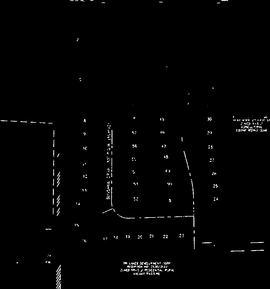
7 Page 14 FIGURE 1


8 Page 15 FIGURE 1

9 Page 16 FIGURE 1
10 Page 17 ( ( 102 E, Pikes Peak Ave,. Ste, 306 Colorado Springs. CO Mail to: P,O, Box 1360 Colorado Springs. CO v ,5485 f 719,444,8427 City of Colorado Springs Planning Department 30 S. Nevada Ave" Suite 102 Colorado Springs, CO January 22, 2014 RE: Project Statement for The Ridge at Cumbre Vista Filing No. 1 Dear Mr. Larsen, The Ridge at Cumbre Vista Filing No.1, is located west of Black Forest Road, South of Cowpoke Road in Section 6, Township 13 South, Range 65 west of the 6 th P.M. in the City of Colorado Springs, EI Paso County, Colorado, also known as the Saddletree Village Master Plan and Annexation. The following package contains a request for approval of a; Development Plan, Final Plat, and a change of Zone for Acres. The site is directly adjacent to the City of Colorado Springs boundary on the west and north sides. [To the west is the Cumbre Vista residential subdivision, to the north is a proposed residential land use within the Wolf Ranch Master Plan.] To the east and south are existing mixed use (Residential/Commercial/Light Industrial) land parcels in El Paso County. The proposed development is planned to consist of approximately 65 single family residential lots, with standard public 50-foot wide street rights-of-way with utilities, sidewalks, etc... The development will be planned and constructed as a "typical" residential subdivision, per normal standards and specifications in the City of Colorado Springs and Colorado Springs Utilities. The lots sizes will average 8,500 square feet. The homes sizes will vary from 1,600-4,000 square feet. Public facilities will include the public streets, utilities, sidewalks, and storm water detention via Sand Creek Regional Detention Basin No.6, and a small portion of the site draining to the Cottonwood Creek Drainage Basin. School and Park fees will be paid in lieu of land dedication. On behalf of the owners of Nextop Holdings, LLC, we respectfully request that attached plans and the associated applications be reviewed for comment by the City of Colorado Springs land development staff. Sincerely, Virgil A. Sanchez, P.E. FIGURE 2


11 Page 18 FIGURE 3
CITY PLANNING COMMISSION AGENDA ITEM NO: B STAFF: LARRY LARSEN FILE NO: CPC ZC QUASI-JUDICIAL
 Page 15 CITY PLANNING COMMISSION AGENDA ITEM NO: B STAFF: LARRY LARSEN FILE NO: CPC ZC 14-00079 - QUASI-JUDICIAL PROJECT: APPLICANT: OWNER: PK ZONING FOR NEIGHBORHOOD PARK IN THE TRAILS AT FOREST MEADOWS
CONSENT CALENDAR CITY PLANNING COMMISSION AGENDA ITEM: A.1-A.3 STAFF: STEVE TUCK
 Page 8 CONSENT CALENDAR CITY PLANNING COMMISSION AGENDA ITEM: A.1-A.3 STAFF: STEVE TUCK FILE NOS: 1. - CPC MPA 07-00308-A4MJ09 LEGISLATIVE 2. - CPC PUZ 09-00057 QUASI-JUDICIAL 3. - CPC PUD 09-00058 QUASI-JUDICIAL
CITY PLANNING COMMISSION AGENDA. ITEM NO(s): C.1 C.3 STAFF: STEVE TUCK
: C.1 C.3 STAFF: STEVE TUCK") Page 34 CITY PLANNING COMMISSION AGENDA ITEM NO(s): C.1 C.3 STAFF: STEVE TUCK FILE NOS: CPC ZC 12-00035 QUASI-JUDICIAL CPC NV 12-00036 QUASI-JUDICIAL AR DP 12-00039 QUASI-JUDICIAL PROJECT: APPLICANT: OWNER:
Page 34 CITY PLANNING COMMISSION AGENDA ITEM NO(s): C.1 C.3 STAFF: STEVE TUCK FILE NOS: CPC ZC 12-00035 QUASI-JUDICIAL CPC NV 12-00036 QUASI-JUDICIAL AR DP 12-00039 QUASI-JUDICIAL PROJECT: APPLICANT: OWNER:
CITY PLANNING COMMISSION AGENDA. ITEM NO: 6.a 6.b STAFF: LONNA THELEN
 Page 156 CITY PLANNING COMMISSION AGENDA ITEM NO: 6.a 6.b STAFF: LONNA THELEN FILE NO(S): A. - CPC ZC 08-00069 QUASI-JUDICIAL B. - CPC CU 08-00070 QUASI-JUDICIAL PROJECT: APPLICANT: OWNER: PHIL LONG VALUCAR
CITY PLANNING COMMISSION AGENDA
 Page 22 CITY PLANNING COMMISSION AGENDA ITEM: C STAFF: STEVE TUCK FILE NO: CPC CU 11-00080 QUASI-JUDICIAL PROJECT: FIRST & MAIN APARTMENTS PHASE 1 APPLICANT: OWNER: NASS DESIGN ASSOCIATES FIRST & MAIN
CITY PLANNING COMMISSION AGENDA ITEMS: C.1, C.2 STAFF: MEGGAN HERINGTON FILE NO(S): CPC PUZ QUASI-JUDICIAL CPC PUD QUASI-JUDICIAL
: CPC PUZ QUASI-JUDICIAL CPC PUD QUASI-JUDICIAL") Page 32 CITY PLANNING COMMISSION AGENDA ITEMS: C.1, C.2 STAFF: MEGGAN HERINGTON FILE NO(S): CPC PUZ 13-00036 QUASI-JUDICIAL CPC PUD 13-00037 QUASI-JUDICIAL PROJECT: APPLICANT: OWNER: ESTANCIA AT CORDERA
Page 32 CITY PLANNING COMMISSION AGENDA ITEMS: C.1, C.2 STAFF: MEGGAN HERINGTON FILE NO(S): CPC PUZ 13-00036 QUASI-JUDICIAL CPC PUD 13-00037 QUASI-JUDICIAL PROJECT: APPLICANT: OWNER: ESTANCIA AT CORDERA
CITY PLANNING COMMISSION AGENDA ITEM: C STAFF: ROBERT TEGLER FILE NO: CPC PUD QUASI-JUDICIAL
 CPC AGENDA June 8, 2006 Page 37 CITY PLANNING COMMISSION AGENDA ITEM: C STAFF: ROBERT TEGLER FILE NO: CPC PUD 05-294 - QUASI-JUDICIAL PROJECT: APPLICANT: OWNER: PARKWOOD AT WOLF RANCH NASS DESIGN ASSOCIATES
CITY PLANNING COMMISSION AGENDA ITEM NO: 11 STAFF: JIM GAGLIARDI FILE NO: CPC CU QUASI-JUDICIAL
 Page 203 CITY PLANNING COMMISSION AGENDA ITEM NO: 11 STAFF: JIM GAGLIARDI FILE NO: CPC CU 08-00095 QUASI-JUDICIAL PROJECT: APPLICANT: OWNER: CHARTER SCHOOL CONDITIONAL USE PERMIT LAND DEVELOPMENT CONSULTANTS,
CITY PLANNING COMMISSION AGENDA ITEMS: 11, 12, 13 STAFF: RYAN TEFERTILLER
 Page 139 CITY PLANNING COMMISSION AGENDA ITEMS: 11, 12, 13 STAFF: RYAN TEFERTILLER FILE NO(s): CPC PUZ 05-00047 QUASI-JUDICIAL CPC PUD 05-00048 QUASI-JUDICIAL CPC FP 05-00049 QUASI-JUDICIAL PROJECT: RIDGEVIEW
SITE CITY PLANNING COMMISSION AGENDA ITEM NO: 5 STAFF: LONNA THELEN FILE NO: CPC CU QUASI-JUDICIAL ART C. KLEIN CONSTRUCTION
 Page 58 CITY PLANNING COMMISSION AGENDA ITEM NO: 5 STAFF: LONNA THELEN FILE NO: CPC CU 10-00022 QUASI-JUDICIAL PROJECT: APPLICANT: OWNER: COLORADO SPRINGS CHARTER ACADEMY ART C. KLEIN CONSTRUCTION COLORADO
Drexel, Barrell & Co.
 Drexel, Barrell & Co. December 21, 2018 Engineers/Surveyors Boulder Colorado Springs Greeley 3 South 7 th Street Colorado Springs, Colorado 80905-1501 719 260-0887 719 260-8352 Fax El Paso County Planning
CITY PLANNING COMMISSION AGENDA
 Page 198 CITY PLANNING COMMISSION AGENDA ITEM NO: 7 STAFF: RYAN TEFERTILLER FILE NO: CPC CU 13-00022 QUASI-JUDICIAL PROJECT: APPLICANT: OWNER: GABION APARTMENTS SPRINGS ENGINEERING C & A PROPERTIES, LLC
Drexel, Barrell & Co.
 Drexel, Barrell & Co. June 18, 2018 Engineers/Surveyors Boulder Colorado Springs Greeley 3 South 7 th Street Colorado Springs, Colorado 80905-1501 719 260-0887 719 260-8352 Fax El Paso County Planning
General Location Courtyard at LMH Final Development Plan and Final Plat
 R-1 LEYDEN RIDGE LOMA RIDGE LOBDELL R-3 MILLER PARKWAY LAUSSAC Subject Property R-3 LOCHENSHIRE LESMER R General Location Courtyard at LMH Final Development Plan and Final Plat ¹ 230 115 0 230 Feet Airport
SPECIFIC PLAN Requirements
 CITY OF LANCASTER PLANNING DEPARTMENT 44933 Fern Avenue, Lancaster, California 93534 (661) 723-6100 SPECIFIC PLAN Requirements Purpose The purpose of a specific plan is to provide for the logical development
CITY OF FORT COLLINS TYPE 1 ADMINISTRATIVE HEARING FINDINGS AND DECISION. CS Commercial, LLC 1337 Riverside Avenue, Unit 1 Fort Collins, CO 80524
 CITY OF FORT COLLINS TYPE 1 ADMINISTRATIVE HEARING FINDINGS AND DECISION HEARING DATE: January 7, 2016 PROJECT NAME: Caring Smiles Dental Clinic CASE NUMBER: FDP #150010 APPLICANT: OWNER: HEARING OFFICER:
Asbury Chapel Subdivision Sketch Plan
 Asbury Chapel Subdivision Sketch Plan PART 1: PROJECT SUMMARY Applicant: NVR Inc. Project Size: +/- 76.13 acres Parcel Numbers: 02101112,02116101,02116112, 02116113 Current Zoning: Transitional Residential
#3) DA AMENDMENT TO DEVELOPMENT AGREEMENT PARK HIGHLANDS - WEST PUBLIC HEARING
 DA AMENDMENT TO DEVELOPMENT AGREEMENT PARK HIGHLANDS - WEST PUBLIC HEARING") #3) DA-03-16 AMENDMENT TO DEVELOPMENT AGREEMENT PARK HIGHLANDS - WEST PUBLIC HEARING STAFF REPORT To: Planning Commission Meeting date: May 11, 2016 Item: DA-03-16 Prepared by: Robert Eastman GENERAL INFORMATION:
#3) DA-03-16 AMENDMENT TO DEVELOPMENT AGREEMENT PARK HIGHLANDS - WEST PUBLIC HEARING STAFF REPORT To: Planning Commission Meeting date: May 11, 2016 Item: DA-03-16 Prepared by: Robert Eastman GENERAL INFORMATION:
CITY PLANNING COMMISSION AGENDA ITEM NO: 8 STAFF: ANDREW FIRESTINE FILE NO: CPC PUD QUASI-JUDICIAL
 Page 97 CITY PLANNING COMMISSION AGENDA ITEM NO: 8 STAFF: ANDREW FIRESTINE FILE NO: CPC PUD 05-00232 QUASI-JUDICIAL PROJECT: APPLICANT: OWNER: CORNERSTONE BAPTIST CHURCH BILL BROWN AIA P.C. CORNERSTONE
ARTICLE 6: Special and Planned Development Districts
 ARTICLE 6: Special and Planned Development Districts 6-10 Traditional Neighborhood Development (TND) District 6-10.10 Purpose and Intent The Traditional Neighborhood Development (TND) District provides
Neo-Traditional Overlay Application
 MAYOR AND CITY COUNCIL OF LAUREL DEPARTMENT OF ECONOMIC AND COMMUNITY DEVELOPMENT 8103 Sandy Spring Road Laurel, Maryland 20707 (301) 725-5300 Internet Address http://www.cityoflaurel.org E-mail: ecd@laurel.md.us
PLANNED UNIT DEVELOPMENT Date: April 5, 2018
 PLANNED UNIT DEVELOPMENT Date: April 5, 2018 DEVELOPMENT NAME SUBDIVISION NAME LOCATION Robert Myers Robert Myers 2955 and 2989 Dauphin Street (Southeast corner of Dauphin Street and Sage Avenue) CITY
The Development Review Process. Presentation to the GSSC IAC
 The Development Review Process Presentation to the GSSC IAC July 19, 2011 Regulatory Processes in the Planning Department Natural Resource Inventory/Forest Stand Delineation Zoning (Development Plan) Special
13. PRELIMINARY PLAT NO MILLS FARM - Vicinity of the southeast corner of 159 th Street and Quivira Road
 13. corner of 159 th Street and Quivira Road 1. APPLICANT: HNTB Corporation is the applicant for this request. 2. REQUESTED ACTION: The applicant is requesting approval of a preliminary plat for a 383-lot
BYLAW C A Bylaw of Rocky View County to amend Land Use Bylaw C
 BYLAW C-7720-2017 A Bylaw of Rocky View County to amend Land Use Bylaw C-4841-97. The Council of Rocky View County enacts as follows: PART 1 TITLE This Bylaw shall be known as Bylaw C-7720-2017. PART 2
Planned Development Review Revisions (Project No. PLNPCM )
") Planned Development Review Revisions (Project No. PLNPCM2014-00139) Standard residential development Planned Development Example: Smaller lot sizes than what is allowed to create open space amenity. What
Planned Development Review Revisions (Project No. PLNPCM2014-00139) Standard residential development Planned Development Example: Smaller lot sizes than what is allowed to create open space amenity. What
REZONING GUIDE. Zone Map Amendment (Rezoning) - Application. Rezoning Application Page 1 of 3. Return completed form to
 - Application. Rezoning Application Page 1 of 3. Return completed form to") Zone Map Amendment (Rezoning) - Application COMMUNITY PLANNING & DEVELOPMENT REZONING GUIDE Rezoning Application Page 1 of 3 PROPERTY OWNER INFORMATION* CHECK IF POINT OF CONTACT FOR APPLICATION Property
Zone Map Amendment (Rezoning) - Application COMMUNITY PLANNING & DEVELOPMENT REZONING GUIDE Rezoning Application Page 1 of 3 PROPERTY OWNER INFORMATION* CHECK IF POINT OF CONTACT FOR APPLICATION Property
RRW Stonebrook, LLC Tentative Map Findings
 RRW Stonebrook, LLC Tentative Map Findings FINDING T1: The request conforms to the Master Plan and zoning ordinances. RELATIONSHIP TO THE MASTER PLAN 1. The respective development is located within an
Approved: CITY OF ARDEN HILLS, MINNESOTA PLANNING COMMISSION WEDNESDAY, AUGUST 5, :30 P.M. - ARDEN HILLS CITY HALL
 Approved: CITY OF ARDEN HILLS, MINNESOTA PLANNING COMMISSION WEDNESDAY, AUGUST 5, 2015 6:30 P.M. - ARDEN HILLS CITY HALL PLANNING CASES A. Planning Case 15-016; Final Planned Unit Development Arden Plaza;
VILLAGE OF CLEMMONS PLANNING BOARD DRAFT STAFF REPORT. Single Family Residential, Townhomes
 VILLAGE OF CLEMMONS PLANNING BOARD DRAFT STAFF REPORT PETITION INFORMATION Docket # C-212 Staff Megan Ledbetter Petitioner(s) Peacehaven Development LLC Owner(s) Larry Jarvis, William Alexander and Peacehaven
APPLICATION FOR REZONING PROPERTY CITY OF HOLLAND, MICHIGAN. Name of Applicant. Address, and Phone # of Applicant
 APPLICATION FOR REZONING PROPERTY CITY OF HOLLAND, MICHIGAN Name of Applicant Address, Email and Phone # of Applicant Name and Address of Owner (if other than applicant) Ownership Interest of Applicant
TEN MILE PLANNING COMMISSION AGENDA January 10, :30 p.m. Buffalo Mountain Meeting Room, County Commons 0037 Peak One Dr., SCR 1005, Frisco, CO
 PLANNING DEPARTMENT 970.668.4200 0037 Peak One Dr. PO Box 5660 www.summitcountyco.gov Frisco, CO 80443 TEN MILE PLANNING COMMISSION AGENDA January 10, 2019-5:30 p.m. Buffalo Mountain Meeting Room, County
COMMISSION ACTION FORM
 ITEM #: 6 DATE: 09-06-17 COMMISSION ACTION FORM REQUEST: Introduction and Initial Review of Proposed Amendments to the Ames Urban Fringe Future Land Map for the North Growth Gap Area BACKGROUND INFORMATION:
Staff Report to the North Ogden City Planning Commission
 Staff Report to the North Ogden City Planning Commission SYNOPSIS / APPLICATION INFORMATION Application Request: Concept review on a legislative application to rezone land located at approximately 1750
4.1.3 LAND USE CATEGORIES
 4.1.3 LAND USE CATEGORIES a. City Center District The City Center District incorporates the existing character and mix of uses in downtown Belmont to encourage redevelopment and new development in keeping
City of Fort Lupton Administrative Site Plan Process
 City of Fort Lupton Administrative Site Plan Process Purpose The Site Plan process is meant to promote orderly and sound development standards as they apply to the City. These site development standards
Planning Commission Staff Report June 5, 2008
 Owner/Applicant Taylor Village Sacramento Investments Partners, LP c/o Kim Whitney 1792 Tribute Road #270 Sacramento, CA 95815 Staff Recommendation Planning Commission Staff Report Project: File: Request:
CITY OF KEIZER MASTER PLAN APPLICATION & INFORMATION SHEET
 CITY OF KEIZER MASTER PLAN APPLICATION & INFORMATION SHEET PRE-APPLICATION CONFERENCE Prior to the actual filing of a Master Plan application, it is strongly recommended that the applicant contact Planning
At Your Disposal CUP Amendment, Lot 20, Village Service Commercial, at 128 Bastille Dr. (PLN17-208)
") MEMORANDUM Archuleta County Development Services Planning Department 1122 HWY 84 P. O. Box 1507 Pagosa Springs, Colorado 81147 970-264-1390 Fax 970-264-3338 TO: Archuleta County Planning Commission FROM:
MEMORANDUM Archuleta County Development Services Planning Department 1122 HWY 84 P. O. Box 1507 Pagosa Springs, Colorado 81147 970-264-1390 Fax 970-264-3338 TO: Archuleta County Planning Commission FROM:
Re: Thorncreek Commons Commercial Response to Pre-Application Meeting held September 24, 2014 Comments
 8/20/2015 Jay Ruchti Senior Planner City Development Department City of Thornton 9500 Civic Center Drive Thornton, CO Re: Thorncreek Commons Commercial Response to Pre-Application Meeting held September
PART 1: PROJECT SUMMARY. Proposed Land Use: 120 single-family lots. The application is Attachment A. The site plan is Attachment B.
 PART 1: PROJECT SUMMARY Applicant: JBH Development, LLC and Hopper Communities, INC Project Size: +/- 80.48 acres Parcel Number: 01513107, 01513108, 01513109, 01513113, 01513120, 01513121, 01513122, 01513124,
Applicant Name Phone / Fax / Address City State Zip Code . Property Owner Phone / Fax / Address City State Zip Code
 Master Development Plan Application Community Development Department City of Redmond 411 SW 9 th Street Redmond, Oregon 97756 541-923-7721 541-548-0706 FAX Master Development Plan Fee $38,862.52 File Number
Steering Committee Meeting
 Neighborhood Planning Initiative NPI EAST CENTRAL AREA PLAN Steering Committee Meeting November 9, 2017 6:00PM 8:00PM Tears McFarlane House East Central Area Plan Steering Committee Meeting 11/9/17 AGENDA
PLANNED UNIT DEVELOPMENT & SUBDIVISION STAFF REPORT Date: May 18, 2017
 & PUD-0000102-2017 PLANNED UNIT DEVELOPMENT & SUBDIVISION STAFF REPORT Date: May 18, 2017 NAME SUBDIVISION NAME Dauphin Creek Estates Subdivision Dauphin Creek Estates Subdivision LOCATION CITY COUNCIL
EXHIBIT B PROJECT NARRATIVE POULSBO MEADOWS
 EXHIBIT B PROJECT NARRATIVE POULSBO MEADOWS Name of Project: Poulsbo Meadows; A Planned Residential Development (PRD)/Plat Applicants Name: PBH Group LLC/Byron Harris PO Box 1010 Silverdale, WA 98038 Description
PLANNED UNIT DEVELOPMENT PUD For The Proposed Antietam Subdivision Escambia County, Florida. Introduction
 PLANNED UNIT DEVELOPMENT PUD For The Proposed Antietam Subdivision Escambia County, Florida Introduction The project is located in Escambia County approximately 0.75 + miles north of the US Highway 90,
TEN MILE PLANNING COMMISSION AGENDA March 14, :30 p.m. Buffalo Mountain Meeting Room, County Commons 0037 Peak One Dr., SCR 1005, Frisco, CO
 PLANNING DEPARTMENT 970.668.4200 0037 Peak One Dr. PO Box 5660 www.summitcountyco.gov Frisco, CO 80443 TEN MILE PLANNING COMMISSION AGENDA March 14, 2019-5:30 p.m. Buffalo Mountain Meeting Room, County
TO: Denver Planning Board FROM: Analiese Hock, Senior City Planner DATE: March 13, 2018 RE:
 Community Planning and Development Planning Services 201 W. Colfax Ave., Dept. 205 Denver, CO 80202 p: 720.865.2915 f: 720.865.3052 www.denvergov.org/cpd TO: Denver Planning Board FROM: Analiese Hock,
General Location Annex, Rezone & Preliminary Plat Lansdowne Addition, Unit Three
 NEWFOUNDLAND I-5 Agricultural District Subject Site SUNDANCE ANDERSON Single Family Residential CHRISTY PUD Agricultural District Highway Business General Location Annex, Rezone & Preliminary Plat Lansdowne
Bayview Ridge PUD and Development Standards Makers Draft April 16, 2013
 April 16, 2013 Part I: Purpose and Applicability...4 14.46.100 Purpose.... 4 14.46.110 Applicability.... 4 Part II: Applications/Review Process...7 14.46.200 Applications/review process Overview.... 7
MASTER DEVELOPMENT DRAINAGE PLAN FOR MONUMENT HEIGHTS
 MASTER DEVELOPMENT DRAINAGE PLAN FOR MONUMENT HEIGHTS DRAINAGE REPORT STATEMENT ENGINEER'S STATEMENT: The attached drainage plan and report were prepared under my direction and supervision and are correct
REQUEST FOR QUALIFICATIONS
 REQUEST FOR QUALIFICATIONS VILLAGE OF HAMBURG COMPREHENSIVE ZONING/LAND USE REGULATIONS UPDATE Prepared By: Village of Hamburg 100 Main Street Hamburg, New York 14075 Village of Hamburg RFQ Page 1 of 10
M E M O R A N D U M. Chair and Members of North West Planning Advisory Committee
 Item 9.1.1 PO Box 1749 Halifax, Nova Scotia B3J 3A5 Canada M E M O R A N D U M TO: FROM: Chair and Members of North West Planning Advisory Committee Stephanie Salloum, Planner II DATE: June 26, 2017 SUBJECT:
Staff Report and Recommendation
 Community Planning and Development Planning Services 201 W. Colfax Ave., Dept. 205 Denver, CO 80202 p: 720.865.2915 f: 720.865.3052 www.denvergov.org/cpd TO: City Council Neighborhoods and Planning Committee
2. Would the proposed project comply with the Land Use map? 3. Would the proposed project require a rezoning? 4. What is the proposed zoning district?
 TOWN OF CHAPEL HILL Planning and Sustainability Department 405 Martin Luther King Jr. Blvd. Chapel Hill, NC 27514 www.townofchapelhill.org phone (919) 968 2728 Concept Plans are intended to be an opportunity
Land Use Amendment in Southwood (Ward 11) at and Elbow Drive SW, LOC
 at and Elbow Drive SW, LOC") 2018 November 15 Page 1 of 10 EXECUTIVE SUMMARY This land use amendment application was submitted by Rick Balbi Architect on 2017 August 31 on behalf of Sable Developments Ltd, and with authorization from
2018 November 15 Page 1 of 10 EXECUTIVE SUMMARY This land use amendment application was submitted by Rick Balbi Architect on 2017 August 31 on behalf of Sable Developments Ltd, and with authorization from
SUBMITTAL REQUIREMENTS
 WHEN PROCESS TYPE III IS USED References to Process Type III applications are found in several places in the Milton Municipal Code (MMC), indicating that the development, activity, or use, is permitted
CITY OF COLWICH COMPREHENSIVE PLAN LAND USE LAND USE 1
 LAND USE LAND USE 1 WHAT YOU WILL FIND IN THIS CHAPTER: Discussion of today s conditions and tomorrow s projections Discussion of challenges and opportunities Discussion of the environmental quality goals,
City Of Sparks Planning Commission Item
 Page 1 of 12 City Of Sparks Planning Commission Item Meeting Date: May17, 2012 Subject: PCN12009, Public Hearing, Consideration and possible action on a Master Plan Amendment and Rezoning request to change
12 January 12, 2011 Public Hearing APPLICANT: TAILWIND DEVELOPMENT GROUP,LLC PROPERTY OWNER: CITY OF VIRGINIA BEACH
 12 January 12, 2011 Public Hearing APPLICANT: TAILWIND DEVELOPMENT GROUP,LLC PROPERTY OWNER: CITY OF VIRGINIA BEACH STAFF PLANNER: Faith Christie REQUEST: Conditional Change of Zoning (from PD-H1 Planned
CITY COUNCIL STUDY SESSION MEMORANDUM
 City and County of Broomfield, Colorado CITY COUNCIL STUDY SESSION MEMORANDUM To: From: Prepared by: Mayor and City Council Charles Ozaki, City and County Manager Kevin Standbridge, Deputy City and County
PLANNING AND ZONING COMMISSION AGENDA MEMORANDUM
 To: Planning and Zoning Commission From: John Hilgers, Planning Director Anna Bertanzetti, Principal Planner Meeting Date Agenda Category Agenda Item # March 14, 2016 Commission Business 4.c. 1. Public
Application for a Site Plan Review
 Application for a Site Plan Review Municipality of Anchorage Planning Department PO Box 196650 Anchorage, AK 99519-6650 PETITIONER* Name (last name first) Mailing Address PETITIONER REPRESENTATIVE (IF
LAND USE AMENDMENT CORNERSTONE (WARD 3) 60 STREET NE AND COUNTRY HILLS BOULEVARD NE MAP 26NE BYLAW 22D2017
 60 STREET NE AND COUNTRY HILLS BOULEVARD NE MAP 26NE BYLAW 22D2017") Page 1 of 14 EXECUTIVE SUMMARY This Land Use Amendment application covers an area of 43.76 hectares ± (108.14 acres ±) located in northeast Calgary, bound by Country Hills Boulevard NE to the south and
Page 1 of 14 EXECUTIVE SUMMARY This Land Use Amendment application covers an area of 43.76 hectares ± (108.14 acres ±) located in northeast Calgary, bound by Country Hills Boulevard NE to the south and
COMMUNITY DESIGN. GOAL: Create livable and attractive communities. Intent
 COMMUNITY DESIGN Intent An attractive, well-designed County will attract quality development, instill civic pride, improve the visual character of the community, and create a strong, positive image for
CHAPTER 1. Ms. Guajardo s Class - Central Elementary CH 1 1
 INTRODUCTION CHAPTER 1 Ms. Guajardo s Class - Central Elementary CH 1 1 1.1 SETTING South Centre City is a linear corridor south of Downtown Escondido paralleling Centre City Parkway and South Escondido
Green Gables. April 24, 2013
 Green Gables Preliminary and Final Plat April 24, 2013 Development Team Green Gables Development Corporation (Owner/Developer) DTJ Design (Planner/Landscape Architect) Enertia Consulting Group (Civil Engineer)
Major Subdivision Sketch Plan Checklist
 This checklist provides specific requirements that are apart of the Sketch process. The entire process is described by the Huntersville Subdivision Review Process which details all the submittal and resubmittal
2. Would the proposed project comply with the Land Use map? 3. Would the proposed project require a rezoning? 4. What is the proposed zoning district?
 TOWN OF CHAPEL HILL Planning and Sustainability Department 405 Martin Luther King Jr. Blvd. Chapel Hill, NC 27514 www.townofchapelhill.org phone (919) 9682728 Concept Plans are intended to be an opportunity
PINE CURVE REZONING. BACKGROUND Purchased as two parcels in 2001 and 2002
 BACKGROUND Purchased as two parcels in 2001 and 2002 WHAT THE PROJECT IS AND IS NOT A Rezoning establishes the land use standards for Annexed and Zoned Greater Downtown District Historic Center September
ROAD CLOSURE AND LAND USE AMENDMENT SILVER SPRINGS (WARD 1) NORTHEAST OF NOSEHILL DRIVE NW AND SILVER SPRINGS ROAD NW BYLAWS 2C2018 AND 29D2018
 NORTHEAST OF NOSEHILL DRIVE NW AND SILVER SPRINGS ROAD NW BYLAWS 2C2018 AND 29D2018") Page 1 of 19 EXECUTIVE SUMMARY This application proposes redesignating two parcels in the community of Silver Springs from Special Purpose Future Urban Development (S-FUD) District and undesignated road
Page 1 of 19 EXECUTIVE SUMMARY This application proposes redesignating two parcels in the community of Silver Springs from Special Purpose Future Urban Development (S-FUD) District and undesignated road
Application Number: SD Project Name: Walton Farms Preliminary Subdivision (acting as Master Plan)
") STAFF REPORT Town of Clayton Planning Department 111 E. Second Street, Clayton, NC 27520 P.O. Box 879, Clayton, NC 27528 Phone: 919-553-5002 Fax: 919-553-1720 Planning Board May 22, 2017 Application Number:
STAFF REPORT Town of Clayton Planning Department 111 E. Second Street, Clayton, NC 27520 P.O. Box 879, Clayton, NC 27528 Phone: 919-553-5002 Fax: 919-553-1720 Planning Board May 22, 2017 Application Number:
VILLAGE OF CLEMMONS PLANNING BOARD DRAFT STAFF REPORT
 VILLAGE OF CLEMMONS PLANNING BOARD DRAFT STAFF REPORT PETITION INFORMATION Docket # C-226 Staff Megan Ledbetter Petitioner(s) JBJH Properties, LLC Owner(s) JBJH Properties, LLC Subject Property 5892-49-1766
CHEBOYGAN COUNTY PLANNING COMMISSION
 CHEBOYGAN COUNTY PLANNING COMMISSION 870 SOUTH MAIN ST. PO BOX 70 CHEBOYGAN, MI 49721 PHONE: (231)627-8489 FAX: (231)627-3646 CHEBOYGAN COUNTY PLANNING COMMISSION MEETING & PUBLIC HEARING WEDNESDAY, NOVEMBER
MIDTOWN MIXED-USE VILLAGE. TECHNICAL DATA SHEET COMPONENT C-1 FOR PUBLIC HEARING - PETITION NUMBER Project No RZ1.1. Issued.
 N MIDTOWN MIXED-USE VILLAGE TECHNICAL DATA SHEET COMPONENT C- FOR PUBLIC HEARING - PETITION NUMBER 04-00 Project No. 496 Issued Revised SCALE: " = 0' N 0 0 0 40 RZ. c GENERAL PROVISIONS: a. SITE LOCATION.
DRAFT Northeast Quadrant of Kipling Avenue and Highway 7 DRAFT AUGUST 29, Goals Land Use. The goals of this Plan are to:
 AUGUST 29, 2017 12.15 Northeast Quadrant of Kipling Avenue and Highway 7 12.15.1 Goals 12.15.2 Land Use The goals of this Plan are to: 12.15.2.1 General Provisions: a) Ensure the development of a compact
Town of Castle Rock DRCOG 2013 Annual Growth and Development Report. Introduction. Section 1 Metro Vision 2035
 Town of Castle Rock DRCOG 2013 Annual Growth and Development Report Introduction This is the Town of Castle Rock s sixth annual report to the Denver Regional Council of Governments (DRCOG) reporting on
CITY PLANNING COMMISSION AGENDA ITEM: K STAFF: STEVE TUCK FILE NO.: CPC CU QUASI-JUDICIAL
 Page 92 CITY PLANNING COMMISSION AGENDA ITEM: K STAFF: STEVE TUCK FILE NO.: CPC CU 08-00043 QUASI-JUDICIAL PROJECT: APPLICANT: OWNER: COTTONWOOD ARTISTS SCHOOL & ART GALLERY COTTONWOOD ARTISTS SCHOOL ELMER
Project phasing plan (if applicable) 12 copies of site plan
 12 copies of site plan") SITE PLAN REVIEW PERMIT APPLICATION City of Grand Haven, 11 N. Sixth Street, Grand Haven, MI 49417 Phone: (616) 847-3490 Fax: (616) 844-2051 Website: www.grandhaven.org 1. Project Information Address/location
SITE PLAN REVIEW PERMIT APPLICATION City of Grand Haven, 11 N. Sixth Street, Grand Haven, MI 49417 Phone: (616) 847-3490 Fax: (616) 844-2051 Website: www.grandhaven.org 1. Project Information Address/location
McDonald s Restaurant - Purcellville Town of Purcellville Special Use Permit Statement of Justification July 24, 2014
 Introduction / Written Statement McDonald s Restaurant - Purcellville McDonald s Corporation is proposing to redevelop the existing McDonald s eating establishment with a drive-through located at 121 N
Rezoning Petition Zoning Committee Recommendation August 1, 2017
 Rezoning Petition 2017-090 Zoning Committee Recommendation August 1, 2017 REQUEST LOCATION SUMMARY OF PETITION PROPERTY OWNER PETITIONER AGENT/REPRESENTATIVE COMMUNITY MEETING STATEMENT OF CONSISTENCY
Appendix C: Interim Mixed-Use Evaluation Criteria
 Appendix C: Interim Mixed-Use Evaluation Criteria C-1 Appendix C: Interim Mixed-Use Evaluation Criteria PURPOSE: The implementation of numerous policies contained within the Master Plan hinges on the creation
KNOXVILLE/KNOX COUNTY METROPOLITAN PLANNING COMMISSION
 KNOXVILLE/KNOX COUNTY METROPOLITAN PLANNING COMMISSION FILE #: 12-A-13-UR AGENDA ITEM #: 33 AGENDA DATE: 12/12/2013 APPLICANT: OWNER(S): METRO KNOXVILLE HMA, LLC Metro Knoxville HMA., LLC TAX ID NUMBER:
Colerain Township report to. Hamilton County Regional Planning Commission. December 2, 2010, 1:00PM. t a f f r e p o r t
 Colerain Township report to Hamilton County Regional Planning Commission December 2, 2010, 1:00PM Preliminary Plan: Case No.: ZA2001-04, Forevergreen Prepared By: Amy Bancroft, Land Use Planner t a f f
PLANNING COMMISSION Work Session Meeting Agenda
 PLANNING COMMISSION Work Session Meeting Agenda 5200 85TH AVENUE NORTH BROOKLYN PARK MN 55443 PHONE (763) 424-8000 FAX (763) 493-8391 Wednesday, September 27, 2017-7:00 P.M. Brooklyn Township Room If due
The scale of intervention:
 The scale of intervention: Degree of specificity Is the TND district linked to a specific site? Is it linked to that site s master plan? If more broadly applicable, how will it relate to a variety of sites
COMMISSION ACTION FORM
 ITEM #: 6 DATE: 10-18-17 COMMISSION ACTION FORM REQUEST: Public Hearing on Proposed Amendments to the Ames Urban Fringe Future Land Map and Land Use Policy Plan for the North Growth Gap Area BACKGROUND
Rural Land Use Designations Kittitas County December 6, 2007 Draft
 KITTITAS COUNTY COMMUNITY DEVELOPMENT SERVICES 411 N. Ruby St., Suite 2, Ellensburg, WA 98926 CDS@CO.KITTITAS.WA.US Office (509) 962-7506 Fax (509) 962-7682 Rural Land Use Designations Kittitas County
Planning & Zoning Commission Staff Report
 Planning & Zoning Commission Staff Report Meeting Date: May 26, 2015 Drafted by: Katherine Harrison-Rogers CASE # Z2886 PROJECT NAME: APPLICANT/ REPRESENTATIVE: Shawna Runyan PROPERTY OWNER: 1840 (previously
Urban Planning and Land Use
 Urban Planning and Land Use 701 North 7 th Street, Room 423 Phone: (913) 573-5750 Kansas City, Kansas 66101 Fax: (913) 573-5796 Email: planninginfo@wycokck.org www.wycokck.org/planning To: From: City Planning
3. VISION AND GOALS. Vision Statement. Goals, Objectives and Policies
 Vision Statement Queen Creek s interconnected network of parks, trails, open spaces and recreation opportunities provide safe and diverse activities and programs that sustain its unique, small town, equestrian
Proposed Comprehensive Plan Strategies DRAFT for discussion June 28, 2017
 Proposed Comprehensive Plan Strategies DRAFT for discussion June 28, 2017 Land Use Rural Areas Refine the Farm and Forest area (FF) Update FF boundaries to account for existing lots less than five acres
Future Five. Design/ Development Guidelines. January 2008 Amended June 08 per City Council motion
 Future Five Design/ Development Guidelines January 2008 Amended June 08 per City Council motion 5-Points Design Guidelines Table of Contents I. Introduction 3 II. Area boundaries 4 III. Review Process
AWH REPORT OF THE PLANNING AND DEVELOPMENT DEPARTMENT FOR APPLICATION FOR REZONING ORDINANCE TO PLANNED UNIT DEVELOPMENT
 AWH REPORT OF THE PLANNING AND DEVELOPMENT DEPARTMENT FOR APPLICATION FOR REZONING ORDINANCE TO PLANNED UNIT DEVELOPMENT MAY 8, 2014 The Planning and Development Department hereby forwards to the Planning
Planning Commission April 4, 2013 BOCC Workshop Page 1
 Planning Commission April 4, 2013 BOCC Workshop Page 1 Planning Commission April 4, 2013 BOCC Workshop Page 2 Planning Commission April 4, 2013 BOCC Workshop Page 3 Planning Commission April 4, 2013 BOCC
CHARTER TOWNSHIP OF VAN BUREN PLANNING COMMISSION November 12, 2014 MINUTES
 CHARTER TOWNSHIP OF VAN BUREN PLANNING COMMISSION November 12, 2014 MINUTES Chairperson Thompson called the meeting to order at 7:32 p.m. ROLL CALL: Present: Johnson, Boynton, Kelley, McKenna, Budd, Franzoi
PLANNING COMMISSION. Agenda Item # 3.
 PLANNING COMMISSION Agenda Item # 3. CASE SUMMARY Conditional District Rezoning Planning Commission February 4, 2015 CD-9-215 Jeff Walton, 341-3260, jeff.walton@wilmingtonnc.gov Staff recommendation CONDITIONAL
Narcoossee Roadway Corridor
 Community Meeting Narcoossee Roadway Corridor April 5, 2012 Meeting Agenda Purpose of Meeting Continuation of Study Update Process (Previous Meetings Oct. & Nov., 2011) Tonight s Objective Review Proposals
SOUTH NATOMAS COMMUNITY PLAN
 SOUTH NATOMAS Community Plan Part Three : COMMUNITY PLAN AREAS AND SPECIAL STUDY AREAS SACRAMENTO 2030 GENERAL PLAN Contents Community Location... 3-SN-3 Community Vision... 3-SN-4 Community Profile...
REQUEST Current Zoning: O-15(CD) (office) Proposed Zoning: TOD-M(CD) (transit oriented development mixed-use, conditional)
 (office) Proposed Zoning: TOD-M(CD) (transit oriented development mixed-use, conditional)") Rezoning Petition 2016-117 Zoning Committee Recommendation January 4, 2017 REQUEST Current Zoning: O-15(CD) (office) Proposed Zoning: TOD-M(CD) (transit oriented development mixed-use, conditional) LOCATION
Rezoning Petition 2016-117 Zoning Committee Recommendation January 4, 2017 REQUEST Current Zoning: O-15(CD) (office) Proposed Zoning: TOD-M(CD) (transit oriented development mixed-use, conditional) LOCATION