CITY OF VAUGHAN EXTRACT FROM COUNCIL MEETING MINUTES OF MAY 6, 2014
|
|
|
- Cuthbert Chapman
- 6 years ago
- Views:
Transcription
1 CITY OF VAUGHAN EXTRACT FROM COUNCIL MEETING MINUTES OF MAY 6, 2014 Item 35, Report No. 18, of the Committee of the Whole, which was adopted, as amended, by the Council of the City of Vaughan on May 6, 2014, as follows: By approving: That the recommendation set out in Communication C4 from the Commissioner of Planning, dated May 2, 2014 be approved, as follows: 1. That the Woodbridge Centre Secondary Plan be modified by: a) Replacing Policy c with the following: i) For any new development or redevelopment, provide dry pedestrian access wherever possible. ii) iii) At a minimum, safe pedestrian movement pursuant to the Provincial flood proofing standards shall be required for all new buildings that provide overnight accommodation and/or for any redevelopment where an increase in the number of units that provide overnight accommodation is proposed. For matters not identified in sub-policy (ii), safe pedestrian movement and safe vehicular access and egress for all new buildings shall be provided pursuant to the Provincial flood proofing standards, or achieve the highest level of flood protection determined to be practical by the Toronto and Region Conservation Authority and the City. b) Replacing Policy with the following: 3. Notwithstanding the policies above, no new development, including additions and alterations, shall be permitted on any parcel of land in the Special Policy Area if the following conditions apply: a. The building or structure will be subject to a risk of flooding in excess of 25% over an assumed life of 100 years (approximately 1:350 year flood a probability of occurrence once in every 350 years). b. The development will be subject to flows which due to their velocity and/or depth would be a hazard to life or susceptible to major structural damage as a result of a flood less than or equal to the Regulatory Flood. c. The necessary flood damage reduction measures would increase the risks associated with flooding and erosion on adjacent, upstream or down-stream properties. 2. That staff make the subject modifications in the required reports in the Special Policy Area (SPA) package that will be sent to the Toronto and Region Conservation Authority for endorsement; and That Communication C2 from Ms. Nadia Zuccaro, EMC group Limited, Keele Street, Vaughan, dated April 29, 2014, be received. /2
2 Item 35, CW Report No. 18 Page 2 CITY OF VAUGHAN EXTRACT FROM COUNCIL MEETING MINUTES OF MAY 6, WOODBRIDGE SPECIAL POLICY AREA JUSTIFICATION REPORT FOR THE WOODBRIDGE CENTRE SECONDARY PLAN WARD 2 FILE The Committee of the Whole recommends: 1) That the recommendation contained in the following report of the Commissioner of Planning, Interim Director of Planning / Director of Development Planning, and Manager of Policy Planning, dated April 29, 2014, be approved; 2) That the following be approved in accordance with Communication C3, from the Commissioner of Planning, dated April 28, 2014: 1. That Schedule 3 Density Plan of the Woodbridge Centre Secondary Plan, forming Attachment 1 be modified by changing the permitted density, for the lands municipally known as 56 Woodbridge Avenue and 15 Clarence Street, from a Floor Space Index (FSI) of 0.7 to an FSI of 1.0; and 2. That the Special Policy Area (SPA) Justification Report, Forming Attachment 3, be modified by amending Tables 6-2B and 6-3 to reflect the change in density and the resulting increase of five residential units. 3) That the following deputations and Communications be received: 1. Mr. Gerry Borean, Parente Borean, Highway 7, Woodbridge; and 2. Mr. Adam J. Brown, Sherman Brown, Barristers & Solicitors, Yonge Street, Toronto, and Communications C2 and C5, both dated April 28, 2014; and 4) That the following Communications be received: C1 Ms. Mary Flynn-Guglietti, McMillan LLP, Bay Street, Toronto, dated April 28, 2014; C4 Ms. Rosemarie Humphries, Humphries Planning Group, Chrislea Road, Vaughan, dated April 28, 2014; and C6 Ms. Rosemarie Humphries, Humphries Planning Group, Chrislea Road, Vaughan, dated April 28, Recommendation The Commissioner of Planning, Interim Director of Planning/Director of Development Planning, and Manager of Policy Planning recommend: 1. That the Woodbridge Centre Secondary Plan, forming part of Volume 2 of the City of Vaughan Official Plan (VOP 2010), adopted September 7, 2010 and modified on February 26, 2013 and March 19, 2013, be further modified in accordance with Attachment 1 to this report which includes all changes as described in the matrix (Attachment 2). 2. That the Special Policy Area Justification Report for the Woodbridge Centre Secondary Plan, described generally in the section of this staff report titled, The Woodbridge Special Policy Area Package for Final Ministerial Approval, and provided as Attachment 3, be endorsed by Council. 3. That the draft Zoning By-law Amendment attached hereto as Attachment 4, in response to the Province s one-window comments of December 17, 2013, be received by Council as a /3
3 Item 35, CW Report No. 18 Page 3 CITY OF VAUGHAN EXTRACT FROM COUNCIL MEETING MINUTES OF MAY 6, 2014 component of the Woodbridge SPA Package, and that the draft Zoning By-Law Amendment proceed to a future statutory Public Hearing for public input and discussion. 4. That staff forward the Woodbridge SPA Package comprising this staff report, the resulting Council minutes, the Woodbridge Centre Secondary Plan, the Special Policy Area Justification Report for the Woodbridge Centre Secondary Plan, and the draft Zoning By-law Amendment to the Toronto and Region Conservation Authority Board for endorsement and the Ministry of Municipal Affairs and Housing and Ministry of Natural Resources for final approval. 5. That this report and Council minutes be forwarded to York Region, the Ontario Municipal Board and relevant parties to the OMB hearing as the City s recommended modifications to the Woodbridge Centre Secondary Plan of Volume 2 of VOP 2010 and to Volume 1 of VOP 2010 as it respects Policy Special Policy Areas. 6. Subject to approval by the Minister of Municipal Affairs and Housing and the Minister of Natural Resources of the new Special Policy Areas provisions, it is requested that the Ontario Municipal Board: a) Approve the SPA policies as set out in Section 7.3 Natural Hazard and Special Policy Area Policies and Schedule 9 Special Policy Area, of Volume 2, as recommended for modification herein, as reflected in Attachment 1; b) Amend Policy Special Policy Areas of Volume 1 by: i. deleting the text to said section and replacing it with the following: There is one approved Special Policy Area in the City of Vaughan. It is located in the Humber River Valley in the Woodbridge Community. It is subject to the policies of Section 7.3, Natural Hazard and Special Policy Area Policies and Schedule 9 Special Policy Area of the Woodbridge Centre Secondary Plan, which forms part of Volume 2 of this Plan. The boundary of the Special Policy Area is reflected in Schedule 8 of Volume 1 hereto ; and, ii. replacing Schedule 8 Special Policy Areas to Volume 1 and incorporating the new Special Policy Area boundaries, as established in Schedule 9 Special Policy Area of Volume 2, the Woodbridge Centre Secondary Plan. Contribution to Sustainability Consistent with Green Directions Vaughan, the City s Community Sustainability and Environmental Master Plan, the Secondary Plan will meet the Region of York s requirements for complete communities and the requirements under the Places to Grow Plan for intensification while following key sustainability initiatives outlined by Green Directions Vaughan as listed below: Goals 1 & 5: Goal 2: Goal 2: Goal 3: To demonstrate leadership through green building and urban design policies; To ensure sustainable development and redevelopment; To protect green space and the countryside by establishing a Natural Heritage Network and limiting urban expansion; To ensure that Vaughan is a city that is easy to get around with low environmental impact; /4
4 Item 35, CW Report No. 18 Page 4 CITY OF VAUGHAN EXTRACT FROM COUNCIL MEETING MINUTES OF MAY 6, 2014 Goal 4: Goals 5 & 6: Mixed-use communities in the Vaughan Metropolitan Centre and other Primary and Local Centres, together with an emphasis on design excellence to foster vibrant communities; An overall vision and policy structure that supports the implementation of Green Directions Vaughan. Economic Impact The Vaughan Official Plan 2010, which includes the Woodbridge Centre Secondary Plan, establishes the planning framework for development throughout the City to The Official Plan, will have a positive impact on the City of Vaughan in terms of managing growth and fostering employment opportunities while fulfilling the City s obligations to conform to Provincial policies and meet Regionally imposed targets for residential and employment growth. There is no economic impact as a result of the proposed review and changes to the Official Plan. Communications Plan Notice of this meeting has been communicated to the public as follows: Purpose Posted on the online calendar, Vaughan Tomorrow website City Page Online and City Update (corporate monthly e-newsletter); To all appellants to VOP 2010; To anyone requesting notification specific to this Secondary Plan; and To landowners within the Special Policy Area lands. To request Council consideration and endorsement of the final Special Policy Area Justification Report for the Woodbridge Centre Secondary Plan and associated modifications to the Woodbridge Centre Secondary Plan to reflect comments emanating from additional review of submissions and detailed discussions involving staff from the Ministry of Municipal Affairs and Housing (MMAH) and the Ministry of Natural Resources (MNR) and the Toronto Region Conservation Authority (TRCA). Once Council has endorsed the SPA Justification Report, the TRCA will take the justification report to the Authority s Board of Directors to obtain its endorsement. Having obtained endorsement from the City of Vaughan and the TRCA, the SPA Justification Report can then be forwarded to the Province for final Ministerial approval in accordance with the provisions of Section 3 of the Provincial Policy Statement regarding a Special Policy Area and the Procedures for the Approval of New Special Policy Areas (SPAs) and Modifications to Existing SPAs Under the Provincial Policy Statement 2005 (PPS, 2005), Policy Natural Hazards Special Policy Areas (MNR 2009). Background - Analysis and Options Special Policy Area Review Process The Special Policy Area (SPA) review, which formed a key component of the Woodbridge Focused Area Study, focused on two primary tasks: (1) conducting a flood risk assessment; and (2) establishing the SPA boundary and the undertaking of a land use and policy review. The risk assessment was in the context of the City-wide Emergency Management Plan and considered aspects of geographic risk and operational risk. The proposed SPA policies and boundaries to be approved by the Province are contained in the Woodbridge Centre Secondary Plan. /5
5 Item 35, CW Report No. 18 Page 5 CITY OF VAUGHAN EXTRACT FROM COUNCIL MEETING MINUTES OF MAY 6, 2014 The Special Policy Area Justification Report represents a comprehensive review of the SPA boundaries, the SPA policies and related land use policies in accordance with: (1) the Provincially approved Terms of Reference for the Woodbridge Focused Area Study, which was approved by Council on May 4, 2009; (2) Section 3 of the Provincial Policy Statement (PPS) and relevant parts of the Definitions section regarding SPAs; and (3) the Procedures for the Approval of New Special Policy Areas (SPAs) and Modifications to Existing SPAs Under the Provincial Policy Statement 2005 (PPS, 2005), Policy Natural Hazards Special Policy Areas (MNR 2009). The SPA review was undertaken applying a comprehensive risk management approach in consultation with Vaughan Fire and Rescue Service and has considered land use and risk response. The Woodbridge Centre Secondary Plan demonstrates consistency with the Provincial Policy Statement regarding the SPA. The following provides a brief overview of Council action and the public consultation process for this secondary plan: May 7, 2007 Council approved the Terms of Reference for the New Vaughan Official Plan, which identified the Woodbridge Centre Secondary Plan area as one of the four focused area reviews (studies to be undertaken). May 4, 2009 Council approved the Terms of Reference for the Woodbridge Focused Area Study (WFAS), and adopted the recommendation from the Commissioner of Planning that the firm Office for Urbanism be retained to assist staff with components of the Woodbridge Centre Area Study. May Staff and Council held a half-day charrette to explore design development alternatives for the Market Lane area. September 17, 2009 a public consultation meeting was held to present emerging objectives/principles for future development in the study area, and to receive local community input. February 11, 2010 a public consultation meeting was held to present the draft Secondary Plan and draft urban design policies/guidelines for the study area; and, to receive Woodbridge community input. April 7, 2010 a public consultation meeting was held to present an overview of the proposed Secondary Plan and the main results of the SPA review to the Ward 3 community at a Statutory Public Open House; and, to respond to residents questions and receive comments. April 14, 2010 a public consultation meeting was held to present an overview of the proposed Secondary Plan and the main results of the SPA review to the Ward 2 community at a Statutory Public Open House; and, to respond to residents questions and receive comments. June 14, 2010 Statutory Public Hearing for the Woodbridge Centre Secondary Plan. In May 2010, in advance of the Statutory Public Meeting, the first draft of the SPA Justification Report was posted to the project web site for the Vaughan Official Plan (Vaughan Tomorrow). June 29, 2010 Council Meeting, ratifying the recommendations made by Council at the Statutory Public Hearing. August 31, 2010 A Special Committee of the Whole Meeting was held to consider responses to public, government and agency submissions, for incorporation into the Woodbridge Centre Secondary Plan. /6
6 Item 35, CW Report No. 18 Page 6 CITY OF VAUGHAN EXTRACT FROM COUNCIL MEETING MINUTES OF MAY 6, 2014 September 7, 2010 Council ratified the recommendations made at the August 31, 2010 Special Committee of the Whole Meeting. The following was recommended: 1. That the recommendation contained in the report of the Commissioner of Planning, dated August 31, 2010, be approved; 2. That the deputation from Ms. Rosemarie Humphries, Humphries Planning Group Inc., 216 Chrislea Road, Suite 103, Vaughan, L4L 8S5, be received; and 3. That the written submissions be received. Council adopted the Woodbridge Centre Secondary Plan on September 7, The plan was forwarded to the Region of York for circulation to the prescribed bodies and public agencies for review and comment as required by the Planning Act. Further modifications to the Woodbridge Centre Secondary Plan were adopted by City of Vaughan Council on March 19, 2013 and the recommendation adopted that the report and Council minutes be forwarded to the Ontario Municipal Board and the Region of York as the City of Vaughan s recommended modifications to the Woodbridge Centre Secondary Plan. Regional Council, on October 17, 2013, adopted the recommendation to advise the Ontario Municipal Board that Regional Council supports the approval of the Woodbridge Centre Secondary Plan, except for the policies and schedules pertaining to Special Policy Areas, which require provincial Ministerial approval. In accordance with the approval requirements in Section 4.0 of the document, Procedures for the Approval of New Special Policy Areas (SPAs) and Modifications to Existing SPAs Under the Provincial Policy Statement 2005 (PPS, 2005), Policy Natural Hazards Special Policy Areas (MNR 2009), the City of Vaughan provided a revised SPA Justification Report to the Ministry of Municipal Affairs and Housing (MMAH) and the Ministry of Natural Resources (MNR) in November 2011 for provincial review. The revised SPA Justification Report incorporated recommendations from the TRCA based on their letters of December 13, 2010 and August 15, The Ministry of Municipal Affairs and Housing and the Ministry of Natural Resources provided a preliminary review and requested additional information in their correspondence of April 12, The City s response to the Province s additional information request was provided on March 1, 2013 together with the revised SPA Justification Report. The City s response took into account the TRCA, MNR and City review of technical studies conducted by stakeholders including landowners within the study area. The Ministry of Municipal Affairs and Housing and the Ministry of Natural Resources provided their formal one-window response on December 17, The subject report and attachments respond to the Ministry s most recent letter. Once Council has endorsed the SPA Justification Report, the TRCA will take the SPA Justification Report to the Authority s Board to obtain endorsement. This is tentatively scheduled for the TRCA s meeting on May 23, Having obtained endorsement from the City of Vaughan and the TRCA, the SPA Justification Report can then be forwarded to the Province for final Ministerial approval. Because the Woodbridge Centre Secondary Plan is at the OMB under appeal, along with Volume 1 of VOP 2010, it is recommended that the Board be requested to defer consideration of the existing SPA policies in Volume 1 (Section 3.6.5, Schedule 8) pending the Ministerial approval of the proposed policies in the WCSP. It is intended that the existing SPA policies in Volume 1 be replaced by the proposed SPA policies (Section 7.3) in the Woodbridge Centre Secondary Plan. Section Special Policy Areas of Volume 1 provides: Existing Special Policy Area (SPA) policies and boundaries are included in this subsection and Schedule 8, respectively of this Plan. The existing SPA policies and boundaries shall remain in effect and in force until the proposed SPA policies and boundaries in Section 7.3 /7
7 Item 35, CW Report No. 18 Page 7 CITY OF VAUGHAN EXTRACT FROM COUNCIL MEETING MINUTES OF MAY 6, 2014 and Schedule 9, respectively, of the Woodbridge Centre Secondary Plan have been approved by the Minister of Municipal Affairs and Housing and the Minister of Natural Resources. As such, the Board should also be requested to modify the relevant Region and City endorsed Volume 1 VOP policies once the Woodbridge Centre Secondary Plan policies pertaining to the Special Policy Area have obtained Ministerial approval. Similarly, the Board should be requested to defer consideration of the proposed SPA policies in the Woodbridge Centre Secondary Plan until Ministerial approval has been obtained to allow for the incorporation of any modifications made necessary by the Provincial review. Recommendations to this effect have been included in the Recommendation section of this report. Summary of SPA and Land Use Policy Changes The proposed SPA boundaries result largely from an update of the floodplain modelling provided by the TRCA. The minor adjustments proposed to the existing SPA boundaries as currently set out in the adopted Secondary Plan are a result of the following changes: Parcels designated Natural Areas, including property owned by TRCA, are removed from the SPA as development is not intended to occur on these lands. Parcels designated Parks in SPA #1 are removed from the SPA as development is not intended to occur on these lands, although the proposed SPA boundary includes the longstanding structures (e.g. concrete silos) of the former Hayhoe Mills site if it is determined that these structures can be re-used for ancillary park uses. The Park designation for a public square in the Market Lane area is not removed from the SPA as the precise location of the public square is not yet determined. Lands located inside the previous regulatory floodplain but outside of the updated floodplain were removed from the SPA as development is no longer restricted by provincial or TRCA floodplain management policy in these areas, though they still remain subject to TRCA s Regulation (Ontario Regulation 166/06). New boundaries follow property lines, where applicable, such that properties no longer straddle the boundary between the SPA and the one-zone floodplain area. The SPA policies from previous Official Plan Amendments are largely brought forward in the Council-adopted (September 2010) Woodbridge Centre Secondary Plan. Recommended changes to the SPA policies in Section 7.3 of the Woodbridge Centre Secondary Plan as a result of the SPA review and in response to the Province s comments of December 17, 2013 can be summarized as follows: Given the TRCA mandate under Regulation 166/06 for the management of floodplain lands and river valleys, any action taken as a result of development applications within the TRCA regulated area shall be to the satisfaction of the TRCA rather than in consultation with the TRCA. The floodproofing standard is specified in one clear policy. This is consistent with the policy in OPA 440, but replaces suggested policies in the Council-adopted (September 2010) Secondary Plan in which floodproofing standards varied for several different designations. Given that the Low-Rise designation permits townhouse development (see policy c in Volume 1 of VOP 2010), notwithstanding policies are added to ensure that single-detached units are not converted to townhouse developments in the Low-Rise designation in the SPA, which would otherwise be a form of intensification in the SPA. /8
8 Item 35, CW Report No. 18 Page 8 CITY OF VAUGHAN EXTRACT FROM COUNCIL MEETING MINUTES OF MAY 6, 2014 Clarification of safe access with respect to pedestrian and vehicular traffic and reference to the City s emergency management approach. Land use designations in the SPA are intended to match previous approvals despite all designations being renamed to match those of VOP Land use designations differ somewhat in the following two parts of the SPA, as described more fully in the SPA Justification Report: The Industrial designation associated with the former Hayhoe Mills site is designated Commercial Mixed-Use (1) and Parks, although the Parks designation includes most of the floodplain portion of the former Industrial designation; and, The Mixed Use Commercial designation in OPA 440 at the northwest corner of Clarence Street and Woodbridge Avenue is replaced by Low-Rise Mixed-Use and Mid-Rise Mixed-Use designations in the Woodbridge Centre Secondary Plan. The Woodbridge Special Policy Area Package for Final Ministerial Approval Special Policy Area Justification Report The modifications to the SPA Justification Report requested by the Province in its letter of December 17, 2013 can be summarized below. Clarification of the City of Vaughan Emergency Management Approach. The Province requested a clear endorsement from Vaughan Fire and Rescue Services that the emergency management approach can address flooding hazards. A letter dated February 20, 2014 has been provided to the Ministry of Municipal Affairs (Attachment 5) signed by the Fire Chief, Deputy Fire Chief and Manager of Emergency Planning demonstrating that City staff has the skills, knowledge and ability to manage a flood emergency. Section 2 of the SPA Justification Report has been modified to reflect the contents of the letter from Vaughan Fire and Rescue Service of February 20, Revised Flood Risk Assessment. Section 6 of the SPA Justification Report provides a summary of the flood risk assessment provided in Appendix G, with a focus on the proposed designations in the Woodbridge Centre Secondary Plan for the Woodbridge Commercial Core and clearly illustrating areas of safe access. Flood risk is explained with respect to risk to life thresholds in accordance with the Natural Hazards Technical Guide and quantified by comparing permitted build-out according to OPA 440 with proposed build-out provided for in the Woodbridge Centre Secondary Plan. In summary, the Woodbridge Centre Secondary Plan provides for 102 additional units (in comparison to OPA 440) in the SPA in the Woodbridge Commercial Core. Of this, 83% or 85 units are directed to the low risk part of the SPA. The remaining 17% or 17 units reflect a small increase in dwelling units resulting from attempts to match the density provisions in previous approvals (expressed in units per hectare) with the density provisions specified as Floor Space Index (FSI) in the Vaughan Official Plan and Woodbridge Centre Secondary Plan. Minor Updates to Supporting Appendices. Appendix G describes the broader flood risk assessment, which has been updated to describe high risk and low risk flood conditions according to the risk to life thresholds in the Natural Hazards Technical Guide. Appendix H provides a comparison of the land use designations in OPA 440 and OPA 240 with the designations in the Woodbridge Centre Secondary Plan. This resulted in only minor updates. Appendix I compares SPA policies in previous Plan /9
9 Item 35, CW Report No. 18 Page 9 CITY OF VAUGHAN EXTRACT FROM COUNCIL MEETING MINUTES OF MAY 6, 2014 approvals (i.e. OPA 440) with the modified SPA policies in the Woodbridge Centre Secondary Plan. As such, Appendix I has been updated to reflect the recent modifications to the SPA policies in the Woodbridge Centre Secondary Plan. Woodbridge Centre Secondary Plan The Province s letter of December 17, 2013 identifies 11 minor modifications to the policies of the Woodbridge Centre Secondary Plan. Attachment 2 describes how the City has interpreted the requests for modification from the Province and the recommended response. Draft Zoning By-Law Amendment In its letter of December 17, 2013, the Province requests that a draft amendment to Comprehensive Zoning By-Law 1-88 be provided as a component of the Woodbridge SPA Package. The concern expressed by the Ministry of Municipal Affairs and Housing was that the existing zoning under By-Law 1-88 permitted residential dwellings and/or overnight accommodation uses on certain parcels within the new SPA which exceed the land use permissions in the new Woodbridge Centre Secondary Plan. The draft zoning by-law identifies those sites and removes the residential and/or overnight accommodation uses as permitted uses on a site-specific basis. The draft zoning by-law amendment is intended as an interim measure until By-Law 1-88 is amended to be in conformity with VOP 2010, including the Woodbridge Centre Secondary Plan. The City will proceed with the preparation of the new comprehensive zoning by-law, in accordance with ss. 26(9) of the Planning Act. In order to implement the draft zoning by-law, a statutory Public Hearing will need to occur to obtain public input; a technical report and recommendation prepared for consideration by the Committee of the Whole; and, if approved, the implementing zoning by-law must be prepared and enacted by Council at a future meeting, and then subject to a statutory 20 day appeal period under the provisions of the Planning Act. Relationship to Vaughan Vision 2020/Strategic Plan The Woodbridge Centre Secondary Plan and SPA review is addressed under the objective Plan and Manage Growth & Economic Vitality, which includes the following specific initiatives: Complete and implement the Growth Management Strategy (Vaughan Tomorrow); Conduct the 5-year comprehensive review of the Official Plan as part of the Growth Management Strategy 2031; Conduct a comprehensive Special Policy Area review. Regional Implications The Woodbridge Centre Secondary Plan has been prepared in consultation with Region of York staff and is in conformity with the Region s Official Plan. The SPA review has been conducted in consultation with the Toronto and Region Conservation Authority, the Ministry of Municipal Affairs and Housing, and the Ministry of Natural Resources. This report and the resulting Council minutes will be forwarded to the Region of York for its consideration in the preparation of its report on the approval of the Woodbridge Centre Secondary Plan as part of Volume 2 of the VOP /10
10 CITY OF VAUGHAN EXTRACT FROM COUNCIL MEETING MINUTES OF MAY 6, 2014 Item 35, CW Report No. 18 Page 10 Conclusion The Special Policy Area Justification Report represents a comprehensive review of the SPA boundaries, SPA policies and related land use policies in accordance with: (1) the Provincially approved Terms of Reference for the Woodbridge Focused Area Study, which was approved by Council on May 4, 2009; (2) Section 3 of the Provincial Policy Statement (PPS) and relevant parts of the Definitions section regarding SPAs; and (3) the Procedures for the Approval of New Special Policy Areas (SPAs) and Modifications to Existing SPAs Under the Provincial Policy Statement 2005 (PPS, 2005), Policy Natural Hazards Special Policy Areas (MNR 2009). The SPA review is undertaken within a comprehensive risk management approach in consultation with Vaughan Fire and Rescue Service and has considered land use and risk response. The Woodbridge Centre Secondary Plan demonstrates consistency with the Provincial Policy Statement regarding the SPA. In addition, modifications to the Woodbridge Centre Secondary Plan resulting from this process have been identified and are recommended for approval in this report. In order to move to the ultimate approval of the new SPA boundaries and policies in the Woodbridge Centre Secondary Plan, it is recommended that the recommendations identified in this report be approved. Attachments 1. The Track Changes Version of the Woodbridge Centre Secondary Plan. 2. Tracking Matrix of Modifications to the Woodbridge Centre Secondary Plan in Response to the Province s One-Window Comments of December 17, Special Policy Area Justification Report for the Woodbridge Centre Secondary Plan. 4. Draft Zoning By-Law Amendment for Select Parcels in the SPA (where zoning permissions for dwelling units and/or overnight accommodation exceed the provisions in the Woodbridge Centre Secondary Plan). 5. February 20, 2014 Letter from Vaughan Fire and Rescue Service to the Ministry of Municipal Affairs and Housing. Note: A hard copy of Attachment 3 Appendices A to J are on file in the City Clerk s Department and are available on the City of Vaughan website. Report prepared by: Cameron Balfour, Planner, ext Tony Iacobelli, Senior Environmental Planner, ext (A copy of the attachments referred to in the foregoing have been forwarded to each Member of Council and a copy thereof is also on file in the office of the City Clerk.)
11
12
13
14
15
16
17
18
19
20
21
22
23
24
25
26
27
28
29
30
31
32 COMMITTEE OF THE WHOLE APRIL 29, 2014 WOODBRIDGE SPECIAL POLICY AREA JUSTIFICATION REPORT FOR THE WOODBRIDGE CENTRE SECONDARY PLAN WARD 2 FILE Recommendation The Commissioner of Planning, Interim Director of Planning/Director of Development Planning, and Manager of Policy Planning recommend: 1. That the Woodbridge Centre Secondary Plan, forming part of Volume 2 of the City of Vaughan Official Plan (VOP 2010), adopted September 7, 2010 and modified on February 26, 2013 and March 19, 2013, be further modified in accordance with Attachment 1 to this report which includes all changes as described in the matrix (Attachment 2). 2. That the Special Policy Area Justification Report for the Woodbridge Centre Secondary Plan, described generally in the section of this staff report titled, The Woodbridge Special Policy Area Package for Final Ministerial Approval, and provided as Attachment 3, be endorsed by Council. 3. That the draft Zoning By-law Amendment attached hereto as Attachment 4, in response to the Province s one-window comments of December 17, 2013, be received by Council as a component of the Woodbridge SPA Package, and that the draft Zoning By-Law Amendment proceed to a future statutory Public Hearing for public input and discussion. 4. That staff forward the Woodbridge SPA Package comprising this staff report, the resulting Council minutes, the Woodbridge Centre Secondary Plan, the Special Policy Area Justification Report for the Woodbridge Centre Secondary Plan, and the draft Zoning By-law Amendment to the Toronto and Region Conservation Authority Board for endorsement and the Ministry of Municipal Affairs and Housing and Ministry of Natural Resources for final approval. 5. That this report and Council minutes be forwarded to York Region, the Ontario Municipal Board and relevant parties to the OMB hearing as the City s recommended modifications to the Woodbridge Centre Secondary Plan of Volume 2 of VOP 2010 and to Volume 1 of VOP 2010 as it respects Policy Special Policy Areas. 6. Subject to approval by the Minister of Municipal Affairs and Housing and the Minister of Natural Resources of the new Special Policy Areas provisions, it is requested that the Ontario Municipal Board: a) Approve the SPA policies as set out in Section 7.3 Natural Hazard and Special Policy Area Policies and Schedule 9 Special Policy Area, of Volume 2, as recommended for modification herein, as reflected in Attachment 1; b) Amend Policy Special Policy Areas of Volume 1 by: i. deleting the text to said section and replacing it with the following: There is one approved Special Policy Area in the City of Vaughan. It is located in the Humber River Valley in the Woodbridge Community. It is subject to the policies of Section 7.3, Natural Hazard and Special Policy Area Policies and
33 Schedule 9 Special Policy Area of the Woodbridge Centre Secondary Plan, which forms part of Volume 2 of this Plan. The boundary of the Special Policy Area is reflected in Schedule 8 of Volume 1 hereto ; and, ii. replacing Schedule 8 Special Policy Areas to Volume 1 and incorporating the new Special Policy Area boundaries, as established in Schedule 9 Special Policy Area of Volume 2, the Woodbridge Centre Secondary Plan. Contribution to Sustainability Consistent with Green Directions Vaughan, the City s Community Sustainability and Environmental Master Plan, the Secondary Plan will meet the Region of York s requirements for complete communities and the requirements under the Places to Grow Plan for intensification while following key sustainability initiatives outlined by Green Directions Vaughan as listed below: Goals 1 & 5: Goal 2: Goal 2: Goal 3: Goal 4: Goals 5 & 6: To demonstrate leadership through green building and urban design policies; To ensure sustainable development and redevelopment; To protect green space and the countryside by establishing a Natural Heritage Network and limiting urban expansion; To ensure that Vaughan is a city that is easy to get around with low environmental impact; Mixed-use communities in the Vaughan Metropolitan Centre and other Primary and Local Centres, together with an emphasis on design excellence to foster vibrant communities; An overall vision and policy structure that supports the implementation of Green Directions Vaughan. Economic Impact The Vaughan Official Plan 2010, which includes the Woodbridge Centre Secondary Plan, establishes the planning framework for development throughout the City to The Official Plan, will have a positive impact on the City of Vaughan in terms of managing growth and fostering employment opportunities while fulfilling the City s obligations to conform to Provincial policies and meet Regionally imposed targets for residential and employment growth. There is no economic impact as a result of the proposed review and changes to the Official Plan. Communications Plan Notice of this meeting has been communicated to the public as follows: Posted on the online calendar, Vaughan Tomorrow website City Page Online and City Update (corporate monthly e- newsletter); To all appellants to VOP 2010; To anyone requesting notification specific to this Secondary Plan; and To landowners within the Special Policy Area lands.
34 Purpose To request Council consideration and endorsement of the final Special Policy Area Justification Report for the Woodbridge Centre Secondary Plan and associated modifications to the Woodbridge Centre Secondary Plan to reflect comments emanating from additional review of submissions and detailed discussions involving staff from the Ministry of Municipal Affairs and Housing (MMAH) and the Ministry of Natural Resources (MNR) and the Toronto Region Conservation Authority (TRCA). Once Council has endorsed the SPA Justification Report, the TRCA will take the justification report to the Authority s Board of Directors to obtain its endorsement. Having obtained endorsement from the City of Vaughan and the TRCA, the SPA Justification Report can then be forwarded to the Province for final Ministerial approval in accordance with the provisions of Section 3 of the Provincial Policy Statement regarding a Special Policy Area and the Procedures for the Approval of New Special Policy Areas (SPAs) and Modifications to Existing SPAs Under the Provincial Policy Statement 2005 (PPS, 2005), Policy Natural Hazards Special Policy Areas (MNR 2009). Background - Analysis and Options Special Policy Area Review Process The Special Policy Area (SPA) review, which formed a key component of the Woodbridge Focused Area Study, focused on two primary tasks: (1) conducting a flood risk assessment; and (2) establishing the SPA boundary and the undertaking of a land use and policy review. The risk assessment was in the context of the City-wide Emergency Management Plan and considered aspects of geographic risk and operational risk. The proposed SPA policies and boundaries to be approved by the Province are contained in the Woodbridge Centre Secondary Plan. The Special Policy Area Justification Report represents a comprehensive review of the SPA boundaries, the SPA policies and related land use policies in accordance with: (1) the Provincially approved Terms of Reference for the Woodbridge Focused Area Study, which was approved by Council on May 4, 2009; (2) Section 3 of the Provincial Policy Statement (PPS) and relevant parts of the Definitions section regarding SPAs; and (3) the Procedures for the Approval of New Special Policy Areas (SPAs) and Modifications to Existing SPAs Under the Provincial Policy Statement 2005 (PPS, 2005), Policy Natural Hazards Special Policy Areas (MNR 2009). The SPA review was undertaken applying a comprehensive risk management approach in consultation with Vaughan Fire and Rescue Service and has considered land use and risk response. The Woodbridge Centre Secondary Plan demonstrates consistency with the Provincial Policy Statement regarding the SPA. The following provides a brief overview of Council action and the public consultation process for this secondary plan: May 7, 2007 Council approved the Terms of Reference for the New Vaughan Official Plan, which identified the Woodbridge Centre Secondary Plan area as one of the four focused area reviews (studies to be undertaken). May 4, 2009 Council approved the Terms of Reference for the Woodbridge Focused Area Study (WFAS), and adopted the recommendation from the Commissioner of Planning that the firm Office for Urbanism be retained to assist staff with components of the Woodbridge Centre Area Study. May Staff and Council held a half-day charrette to explore design development alternatives for the Market Lane area.
35 September 17, 2009 a public consultation meeting was held to present emerging objectives/principles for future development in the study area, and to receive local community input. February 11, 2010 a public consultation meeting was held to present the draft Secondary Plan and draft urban design policies/guidelines for the study area; and, to receive Woodbridge community input. April 7, 2010 a public consultation meeting was held to present an overview of the proposed Secondary Plan and the main results of the SPA review to the Ward 3 community at a Statutory Public Open House; and, to respond to residents questions and receive comments. April 14, 2010 a public consultation meeting was held to present an overview of the proposed Secondary Plan and the main results of the SPA review to the Ward 2 community at a Statutory Public Open House; and, to respond to residents questions and receive comments. June 14, 2010 Statutory Public Hearing for the Woodbridge Centre Secondary Plan. In May 2010, in advance of the Statutory Public Meeting, the first draft of the SPA Justification Report was posted to the project web site for the Vaughan Official Plan (Vaughan Tomorrow). June 29, 2010 Council Meeting, ratifying the recommendations made by Council at the Statutory Public Hearing. August 31, 2010 A Special Committee of the Whole Meeting was held to consider responses to public, government and agency submissions, for incorporation into the Woodbridge Centre Secondary Plan. September 7, 2010 Council ratified the recommendations made at the August 31, 2010 Special Committee of the Whole Meeting. The following was recommended: 1. That the recommendation contained in the report of the Commissioner of Planning, dated August 31, 2010, be approved; 2. That the deputation from Ms. Rosemarie Humphries, Humphries Planning Group Inc., 216 Chrislea Road, Suite 103, Vaughan, L4L 8S5, be received; and 3. That the written submissions be received. Council adopted the Woodbridge Centre Secondary Plan on September 7, The plan was forwarded to the Region of York for circulation to the prescribed bodies and public agencies for review and comment as required by the Planning Act. Further modifications to the Woodbridge Centre Secondary Plan were adopted by City of Vaughan Council on March 19, 2013 and the recommendation adopted that the report and Council minutes be forwarded to the Ontario Municipal Board and the Region of York as the City of Vaughan s recommended modifications to the Woodbridge Centre Secondary Plan. Regional Council, on October 17, 2013, adopted the recommendation to advise the Ontario Municipal Board that Regional Council supports the approval of the Woodbridge Centre Secondary Plan, except for the policies and schedules pertaining to Special Policy Areas, which require provincial Ministerial approval. In accordance with the approval requirements in Section 4.0 of the document, Procedures for the Approval of New Special Policy Areas (SPAs) and Modifications to Existing SPAs Under the Provincial Policy Statement 2005 (PPS, 2005), Policy Natural Hazards Special Policy Areas (MNR 2009), the City of Vaughan provided a revised SPA Justification Report to the
36 Ministry of Municipal Affairs and Housing (MMAH) and the Ministry of Natural Resources (MNR) in November 2011 for provincial review. The revised SPA Justification Report incorporated recommendations from the TRCA based on their letters of December 13, 2010 and August 15, The Ministry of Municipal Affairs and Housing and the Ministry of Natural Resources provided a preliminary review and requested additional information in their correspondence of April 12, The City s response to the Province s additional information request was provided on March 1, 2013 together with the revised SPA Justification Report. The City s response took into account the TRCA, MNR and City review of technical studies conducted by stakeholders including landowners within the study area. The Ministry of Municipal Affairs and Housing and the Ministry of Natural Resources provided their formal one-window response on December 17, The subject report and attachments respond to the Ministry s most recent letter. Once Council has endorsed the SPA Justification Report, the TRCA will take the SPA Justification Report to the Authority s Board to obtain endorsement. This is tentatively scheduled for the TRCA s meeting on May 23, Having obtained endorsement from the City of Vaughan and the TRCA, the SPA Justification Report can then be forwarded to the Province for final Ministerial approval. Because the Woodbridge Centre Secondary Plan is at the OMB under appeal, along with Volume 1 of VOP 2010, it is recommended that the Board be requested to defer consideration of the existing SPA policies in Volume 1 (Section 3.6.5, Schedule 8) pending the Ministerial approval of the proposed policies in the WCSP. It is intended that the existing SPA policies in Volume 1 be replaced by the proposed SPA policies (Section 7.3) in the Woodbridge Centre Secondary Plan. Section Special Policy Areas of Volume 1 provides: Existing Special Policy Area (SPA) policies and boundaries are included in this subsection and Schedule 8, respectively of this Plan. The existing SPA policies and boundaries shall remain in effect and in force until the proposed SPA policies and boundaries in Section 7.3 and Schedule 9, respectively, of the Woodbridge Centre Secondary Plan have been approved by the Minister of Municipal Affairs and Housing and the Minister of Natural Resources. As such, the Board should also be requested to modify the relevant Region and City endorsed Volume 1 VOP policies once the Woodbridge Centre Secondary Plan policies pertaining to the Special Policy Area have obtained Ministerial approval. Similarly, the Board should be requested to defer consideration of the proposed SPA policies in the Woodbridge Centre Secondary Plan until Ministerial approval has been obtained to allow for the incorporation of any modifications made necessary by the Provincial review. Recommendations to this effect have been included in the Recommendation section of this report. Summary of SPA and Land Use Policy Changes The proposed SPA boundaries result largely from an update of the floodplain modelling provided by the TRCA. The minor adjustments proposed to the existing SPA boundaries as currently set out in the adopted Secondary Plan are a result of the following changes: Parcels designated Natural Areas, including property owned by TRCA, are removed from the SPA as development is not intended to occur on these lands. Parcels designated Parks in SPA #1 are removed from the SPA as development is not intended to occur on these lands, although the proposed SPA boundary includes the longstanding structures (e.g. concrete silos) of the former Hayhoe Mills site if it is determined that these structures can be re-used for ancillary park uses. The Park designation for a public square in the Market Lane area is not removed from the SPA as the precise location of the public square is not yet determined.
37 Lands located inside the previous regulatory floodplain but outside of the updated floodplain were removed from the SPA as development is no longer restricted by provincial or TRCA floodplain management policy in these areas, though they still remain subject to TRCA s Regulation (Ontario Regulation 166/06). New boundaries follow property lines, where applicable, such that properties no longer straddle the boundary between the SPA and the one-zone floodplain area. The SPA policies from previous Official Plan Amendments are largely brought forward in the Council-adopted (September 2010) Woodbridge Centre Secondary Plan. Recommended changes to the SPA policies in Section 7.3 of the Woodbridge Centre Secondary Plan as a result of the SPA review and in response to the Province s comments of December 17, 2013 can be summarized as follows: Given the TRCA mandate under Regulation 166/06 for the management of floodplain lands and river valleys, any action taken as a result of development applications within the TRCA regulated area shall be to the satisfaction of the TRCA rather than in consultation with the TRCA. The floodproofing standard is specified in one clear policy. This is consistent with the policy in OPA 440, but replaces suggested policies in the Council-adopted (September 2010) Secondary Plan in which floodproofing standards varied for several different designations. Given that the Low-Rise designation permits townhouse development (see policy c in Volume 1 of VOP 2010), notwithstanding policies are added to ensure that single-detached units are not converted to townhouse developments in the Low-Rise designation in the SPA, which would otherwise be a form of intensification in the SPA. Clarification of safe access with respect to pedestrian and vehicular traffic and reference to the City s emergency management approach. Land use designations in the SPA are intended to match previous approvals despite all designations being renamed to match those of VOP Land use designations differ somewhat in the following two parts of the SPA, as described more fully in the SPA Justification Report: The Industrial designation associated with the former Hayhoe Mills site is designated Commercial Mixed-Use (1) and Parks, although the Parks designation includes most of the floodplain portion of the former Industrial designation; and, The Mixed Use Commercial designation in OPA 440 at the northwest corner of Clarence Street and Woodbridge Avenue is replaced by Low-Rise Mixed-Use and Mid-Rise Mixed-Use designations in the Woodbridge Centre Secondary Plan. The Woodbridge Special Policy Area Package for Final Ministerial Approval Special Policy Area Justification Report The modifications to the SPA Justification Report requested by the Province in its letter of December 17, 2013 can be summarized below. Clarification of the City of Vaughan Emergency Management Approach. The Province requested a clear endorsement from Vaughan Fire and Rescue Services that the emergency management approach can address flooding hazards. A letter
38 dated February 20, 2014 has been provided to the Ministry of Municipal Affairs (Attachment 5) signed by the Fire Chief, Deputy Fire Chief and Manager of Emergency Planning demonstrating that City staff has the skills, knowledge and ability to manage a flood emergency. Section 2 of the SPA Justification Report has been modified to reflect the contents of the letter from Vaughan Fire and Rescue Service of February 20, Revised Flood Risk Assessment. Section 6 of the SPA Justification Report provides a summary of the flood risk assessment provided in Appendix G, with a focus on the proposed designations in the Woodbridge Centre Secondary Plan for the Woodbridge Commercial Core and clearly illustrating areas of safe access. Flood risk is explained with respect to risk to life thresholds in accordance with the Natural Hazards Technical Guide and quantified by comparing permitted build-out according to OPA 440 with proposed build-out provided for in the Woodbridge Centre Secondary Plan. In summary, the Woodbridge Centre Secondary Plan provides for 102 additional units (in comparison to OPA 440) in the SPA in the Woodbridge Commercial Core. Of this, 83% or 85 units are directed to the low risk part of the SPA. The remaining 17% or 17 units reflect a small increase in dwelling units resulting from attempts to match the density provisions in previous approvals (expressed in units per hectare) with the density provisions specified as Floor Space Index (FSI) in the Vaughan Official Plan and Woodbridge Centre Secondary Plan. Minor Updates to Supporting Appendices. Appendix G describes the broader flood risk assessment, which has been updated to describe high risk and low risk flood conditions according to the risk to life thresholds in the Natural Hazards Technical Guide. Appendix H provides a comparison of the land use designations in OPA 440 and OPA 240 with the designations in the Woodbridge Centre Secondary Plan. This resulted in only minor updates. Appendix I compares SPA policies in previous Plan approvals (i.e. OPA 440) with the modified SPA policies in the Woodbridge Centre Secondary Plan. As such, Appendix I has been updated to reflect the recent modifications to the SPA policies in the Woodbridge Centre Secondary Plan. Woodbridge Centre Secondary Plan The Province s letter of December 17, 2013 identifies 11 minor modifications to the policies of the Woodbridge Centre Secondary Plan. Attachment 2 describes how the City has interpreted the requests for modification from the Province and the recommended response. Draft Zoning By-Law Amendment In its letter of December 17, 2013, the Province requests that a draft amendment to Comprehensive Zoning By-Law 1-88 be provided as a component of the Woodbridge SPA Package. The concern expressed by the Ministry of Municipal Affairs and Housing was that the existing zoning under By-Law 1-88 permitted residential dwellings and/or overnight accommodation uses on certain parcels within the new SPA which exceed the land use permissions in the new Woodbridge Centre Secondary Plan. The draft zoning by-law identifies those sites and removes the residential and/or overnight accommodation uses as permitted uses on a site-specific basis. The draft zoning by-law amendment is intended as an interim measure until By-Law 1-88 is amended to be in conformity with VOP 2010, including the Woodbridge Centre Secondary Plan. The City will proceed with the preparation of the new comprehensive zoning by-law, in accordance with ss. 26(9) of the Planning Act.
39 In order to implement the draft zoning by-law, a statutory Public Hearing will need to occur to obtain public input; a technical report and recommendation prepared for consideration by the Committee of the Whole; and, if approved, the implementing zoning by-law must be prepared and enacted by Council at a future meeting, and then subject to a statutory 20 day appeal period under the provisions of the Planning Act. Relationship to Vaughan Vision 2020/Strategic Plan The Woodbridge Centre Secondary Plan and SPA review is addressed under the objective Plan and Manage Growth & Economic Vitality, which includes the following specific initiatives: Complete and implement the Growth Management Strategy (Vaughan Tomorrow); Conduct the 5-year comprehensive review of the Official Plan as part of the Growth Management Strategy 2031; Conduct a comprehensive Special Policy Area review. Regional Implications The Woodbridge Centre Secondary Plan has been prepared in consultation with Region of York staff and is in conformity with the Region s Official Plan. The SPA review has been conducted in consultation with the Toronto and Region Conservation Authority, the Ministry of Municipal Affairs and Housing, and the Ministry of Natural Resources. This report and the resulting Council minutes will be forwarded to the Region of York for its consideration in the preparation of its report on the approval of the Woodbridge Centre Secondary Plan as part of Volume 2 of the VOP Conclusion The Special Policy Area Justification Report represents a comprehensive review of the SPA boundaries, SPA policies and related land use policies in accordance with: (1) the Provincially approved Terms of Reference for the Woodbridge Focused Area Study, which was approved by Council on May 4, 2009; (2) Section 3 of the Provincial Policy Statement (PPS) and relevant parts of the Definitions section regarding SPAs; and (3) the Procedures for the Approval of New Special Policy Areas (SPAs) and Modifications to Existing SPAs Under the Provincial Policy Statement 2005 (PPS, 2005), Policy Natural Hazards Special Policy Areas (MNR 2009). The SPA review is undertaken within a comprehensive risk management approach in consultation with Vaughan Fire and Rescue Service and has considered land use and risk response. The Woodbridge Centre Secondary Plan demonstrates consistency with the Provincial Policy Statement regarding the SPA. In addition, modifications to the Woodbridge Centre Secondary Plan resulting from this process have been identified and are recommended for approval in this report. In order to move to the ultimate approval of the new SPA boundaries and policies in the Woodbridge Centre Secondary Plan, it is recommended that the recommendations identified in this report be approved. Attachments 1. The Track Changes Version of the Woodbridge Centre Secondary Plan. 2. Tracking Matrix of Modifications to the Woodbridge Centre Secondary Plan in Response to the Province s One-Window Comments of December 17, Special Policy Area Justification Report for the Woodbridge Centre Secondary Plan. 4. Draft Zoning By-Law Amendment for Select Parcels in the SPA (where zoning permissions for dwelling units and/or overnight accommodation exceed the provisions in the Woodbridge Centre Secondary Plan). 5. February 20, 2014 Letter from Vaughan Fire and Rescue Service to the Ministry of Municipal Affairs and Housing.
40 Note: A hard copy of Attachment 3 Appendices A to J are on file in the City Clerk s Department and are available on the City of Vaughan website. Report prepared by: Cameron Balfour, Planner, ext Tony Iacobelli, Senior Environmental Planner, ext Respectfully submitted, JOHN MACKENZIE Commissioner of Planning GRANT UYEYAMA Interim Director of Planning, and Director of Development Planning ROY MCQUILLIN Manager of Policy Planning /lm
41 ATTACHMENT 1 WOODBRIDGE CENTRE SECONDARY PLAN TABLE OF CONTENTS pg. PART A PREAMBLE OF THE PLAN SUMMARY OF THE WOODBRIDGE CENTRE SECONDARY PLAN Location Plan Process and Public Consultation Purpose, Scope and Focus of the Secondary Plan BACKGROUND AND CONTEXT Background Area History Policy Framework Provincial Policy Statement (PPS) Places to Grow Act, York Region Official Plan (ROP) The New City of Vaughan Official Plan Previous Official Plan Amendments THE VISION FOR THE SECONDARY PLAN Overall Character of Development and Vision Land Use Designations Proposed Land Use Designations in the Woodbridge Centre Secondary Plan Low-Rise Low-Rise Mixed-Use Mid-Rise -Use Mid-Rise Mixed-Use Commercial Mixed-Use (1) Designation Urban Design A Comprehensive Urban Design Framework 12
42 3.4 Parks and Open Space Current and Future Service Levels A Parks and Open Space Framework The Environment Cultural Heritage The Transportation Network Transportation Impact Assessment Streetscape Design Pedestrian Priority Nodes Parking Standards Clarence Street and Woodbridge Avenue 19 PART B DETAILS OF THE PLAN INTRODUCTION AND INTERPRETATION OF THE PLAN Introduction Location PRINCIPLES AND OBJECTIVES THE VISION FOR THE CHARACTER AREAS Woodbridge Commercial Core Islington Avenue Corridor Stable Neighbourhoods LAND USE DESIGNATIONS Land Use Policy Specific to the Woodbridge Commercial Core General Land Use Policies Policies Urban Design Policies Land Use Policies Specific to the Islington Avenue Corridor General Land Use Policies 33
43 4.2.2 Policies Commercial Policies Urban Design Policies Natural Areas URBAN FORM Block Pattern, Street Network and Linkages Clarence Street and Woodbridge Avenue Islington Avenue Highway 7/Islington Avenue Intersection Pedestrian Priority Nodes Heritage Conservation PARKS AND OPEN SPACE FRAMEWORK Open Spaces The Humber River Valley Open Spaces The District Parks Neighbourhood Parks Public Squares Private Open Space The Woodbridge Fairgrounds A Connected System A Complete Trails Network Views The Avenues Kipling, Woodbridge and Islington Public Art THE ENVIRONMENT Natural Heritage Network Locally Important Forest Resources and Landforms Natural Hazard and Special Policy Area Policies Sustainable Development Policies TRANSPORTATION 589
44 8.1 Public Transit Transportation Demand Management (TDM) Structured Parking INTERPRETATION 60 PART C DEFINITIONS AND SCHEDULES 612 Definitions 612 Schedule List 612 Schedule 1: Policy Areas Schedule 2: Land Use Plan Schedule 3: Density Plan Schedule 4: Building Height Maximums Schedule 5: Distinct Character Areas Schedule 6: Parks and Open Space Framework Schedule 7: Pedestrian and Bicycle Trails Network Schedule 8: Street Network, Nodes and Gateways Schedule 9: Special Policy Area Schedules 634
45 PART A PREAMBLE OF THE PLAN 1.0 SUMMARY OF THE WOODBRIDGE CENTRE SECONDARY PLAN 1.1 Location The Secondary Plan generally includes the area between the east boundary of the Kipling Avenue Corridor Secondary Plan to the west, the Humber River valley and Special Policy Area (SPA) lands east of Islington to the east, Langstaff Road to the north and Regional Road 7 to the south. Lands in the SPA south of Regional Road 7 are also subject to the policies of this Plan. The Kipling Avenue area, while forming a part of the study area, is not subject to the policies of this Secondary Plan. The Kipling Avenue Corridor Secondary Plan, formerly Official Plan Amendment 695, which was approved in June 2009, remains as a standalone policy document. See Schedule 1: Policy Areas for the Plan boundaries. 1.2 Plan Process and Public Consultation Plan Process The Woodbridge Centre Secondary Plan process was initiated by the City of Vaughan in March The planning process included a background document review and compilation of policy; a land use and urban design analysis and development of a cohesive vision and principles for the Plan Area; the development of a consolidated policy framework and urban design guidelines; a transportation assessment for the preferred land use scenario; a parking needs and commercial sector review; an assessment of sustainable development measures; a review of the Special Policy Area in terms of boundaries, flood risk, and policy; a parkland/open space assessment review; and finally, the development of a Secondary Plan document. The development of the policy framework included ongoing coordination with the City of Vaughan Official Plan process with respect to aligning overall principles, goals and objectives, and intensification analysis and directions. Public Consultation With the anticipation of changes regarding land use and urban design policies, the Plan Process included a series of public consultation events for the purpose of ensuring public awareness of the changes to the area and to the City, as well as determining resident s objectives for their community, and garnering community participation and input in the development of the Woodbridge Centre Secondary Plan. Participants included residents, property owners, and other key 1
46 community stakeholders, and events were regularly attended by City Staff, Council and associated consultants. The consultation process also integrated Public Open House events held for the purpose of review of the City Official Plan, as well as a focused charrette with City staff and the Sora delegation from Italy for the purpose of generating design scenarios for the development of Market Lane. The following are a list of the combined consultation scenarios: a. The Sora Charrette (May, 2009) Design Development for Market Lane b. Vaughan Official Plan Public Open House (May 28, 2009) c. Woodbridge Centre Study Kick-off Public Open House 1 (September, 2009), included a presentation of the Analysis, Principles, Goals, Objectives, and a Cohesive Vision for the Study Area d. Vaughan Official Plan Public Open House (November, 2009) e. Woodbridge Centre Public Open House 2 (February, 2010), included a presentation of the Draft Land Use and SPA Policies and Urban Design Guidelines f. Woodbridge Centre Ward 2 and 3 Public Open Houses (April, 2010) g. A Statutory Public Hearing (June, 2010) 1.3 Purpose, Scope, and Focus of the Secondary Plan The primary focus of the Plan is to provide guidance for development and investments in the Woodbridge Centre. While much of the Woodbridge Centre area is either stable residential areas or open space, the Plan includes policies to direct modest intensification along Woodbridge Avenue and Islington Avenue. Together with the Kipling Avenue Corridor, Woodbridge Avenue and Islington Avenue comprise the main character areas of the Secondary Plan to which the urban design and land use framework applies. 2
47 The City of Vaughan recently adopted the Woodbridge Heritage Conservation District (HCD) Plan in The Woodbridge HCD provides an over-arching framework for the urban design policies of the Secondary Plan. The Special Policy Area (SPA) review is another key component of the Secondary Plan. SPA policies and boundaries are updated to reflect the most recent policy direction from the Province and revised information and guidelines from the Toronto and Region Conservation Authority regarding flooding hazards and flood vulnerable sites. In addition, the Secondary Plan provides updated land use and policies to ensure conformity of planning policy with current Provincial, Regional, City, and TRCA policies, particularly with respect to issues of intensification, urban design, transportation, sustainable development measures, and the natural environment. 2.0 BACKGROUND AND CONTEXT 2.1 Background In the last seven years the Woodbridge Focused Study Area has been the subject of four studies: the Islington Avenue Study (2002) resulting in OPA 597; the Kipling Corridor Study (2008), resulting in OPA 695; the Woodbridge Heritage Conservation District Study (2008); and the Highway #7 Land Use Study (2007), resulting in OPA 661. Each of these studies had its specific Terms of Reference and focus in relation to the Secondary Plan area. The purpose of the Woodbridge Centre Secondary Plan is to identify any gaps in the overall policy framework for the area, which encompasses the Kipling Avenue Corridor Secondary Plan (formerly OPA 695), the Islington Avenue Corridor OPA 597 area, the Woodbridge Heritage Conservation District Plan area, and a small portion of the Highway #7 OPA 661 area, as identified on Schedule 1: Policy Areas. The remainder of the Secondary Plan Area is subject to the policies of Volume 1 of the City of Vaughan Official Plan. A specific focus of the Plan is to provide an overall urban design framework for the entire Plan area and to update the Special Policy Area (SPA) mapping and policies in consultation with the Toronto and Region Conservation Authority and in accordance with the Provincial Policy Statement. The SPA review informs any decisions to change land use designations in the areas identified as the SPA based on an assessment of flood risk in conjunction with community planning objectives. In addition, the process was to ensure consistency of planning policy with current Provincial, Regional, City, and TRCA policies as mentioned above. 3
48 Since the Kipling Avenue Corridor Study (2008) was just recently completed and entailed a comprehensive review of land uses and urban design, this Secondary Plan does not amend the policies of the Kipling Avenue Corridor Secondary Plan. Part 1 of the City of Vaughan Official Plan sets the general policy context for the Woodbridge Community Area. Where any of the policies of the Secondary Plan conflict with the policies set out in Volume 1 of the Official Plan, the policies of this Secondary Plan shall prevail. However, there are specific instances in the environmental policies of the Secondary Plan where it is noted that the more restrictive policy applies in the event of a conflict. 2.2 Area History Woodbridge is one of four historic villages within the City of Vaughan, and the Woodbridge Heritage Conservation District (HCD) within Woodbridge Centre represents one of the highest concentrations of heritage properties in the City. Woodbridge has always been an attractive place to live and do business since its founding, given its location within the valley and table lands associated with the Humber River; and its proximity to other communities. The Humber River was recently designated as a Canadian Heritage River and is part of the Carrying Place Trail system identified in the Humber River Watershed Plan. 2.3 Policy Framework The Plan area is subject to Provincial, Regional, and municipal policy, some of which are referenced below: Provincial Policy Statement (PPS) The PPS supports efficient land use, a mix of housing types and densities, residential intensification, public transit ridership, and the protection of cultural heritage and natural heritage resources. The PPS provides guidance on the reduction of costs and the risks to public safety with policies on natural hazards. It encourages growth in built up areas by providing opportunity for mixed uses, housing and employment, parks and open spaces, transportation choices and pedestrian movement. Section 3 of the PPS addresses natural hazards, including flooding hazards, and provides direction regarding policies and boundaries applying to a Special Policy Area. 4
49 2.3.2 Places to Grow Act, 2006 The Places to Grow Act provides a vision and growth plan for the Greater Golden Horseshoe in southern Ontario and is based on a set of principles for guiding decisions on how land is to be developed and public investments are managed. The Places to Grow Act supports the following principals: 1. Building compact vibrant neighbourhoods; 2. Protect, conserve, enhance and wisely use valuable natural resources such as land, air and water for current and future generations; 3. Optimize the use of existing and new infrastructure to support growth in a compact, efficient form; 4. Provide for different approaches to managing growth that recognize the diversity of communities; and 5. Promote collaboration among all sectors including government, private and non-profit, and community members to achieve the vision York Region Official Plan (ROP) The York Region Official Plan (ROP) is the upper tier planning document, to which the City of Vaughan s planning documents must conform with respect to goals, objectives, and policies. The ROP provides the framework for the overall planning structure for the Region, including specific guidance and policies for the urban structure and regionally significant areas relevant to the context of this Plan, including: 1. Directing the majority of growth to the Urban Areas identified in the Regional Structure Plan. The Woodbridge Centre Secondary Plan area is located within the identified Urban Area; 2. Protecting and restoring the Regional Greenlands System as a permanent resource of the Region. The Humber River and the Rainbow Creek corridors are identified as part of the Regional Greenlands System; 3. Creating employment opportunities across the Region and reducing the overall levels of travel; 5
50 4. Providing rapid transit services linking the Regional Centres within the adjacent urban area. Highway 7 within the Plan area is identified as a Regional Rapid Transit Corridor; and 5. Promoting healthy communities by providing employment opportunities, encouraging the use of public transit, promoting walking, cycling trails, providing a range of housing options, protecting the natural environment, and improving community partnerships The New City of Vaughan Official Plan The vision for transformation for the new City of Vaughan Official Plan (new City of VaughanV OP 2010, adopted by Council on September 7, 2010 and subject to further modifications on September 27, 2011, March 20, 2012 and April 17, 2012), is based on eight key principles or themes; seven of which relate directly to the Woodbridge Centre Secondary Plan area. These seven principles are described as follows: 1. Strong and Diverse Communities: The Vaughan Official Plan (VOP 2010) seeks to maintain the stability of existing residential communities, direct well designed, sensitive growth to strictly defined areas, and provide for a wide range of housing choices, full range of community services and amenities within each community. 2. A Robust and Prominent Countryside: A focus of the Plan is to maintain a prominent and accessible countryside within Vaughan. 3. A Diverse Economy: Build on Vaughan s economic success through policies which aim to diversify the local economy. 4. Moving Around without a Car: The VOP2010 focuses on planning and design policies that make walking, cycling and transit use realistic options for moving around. 5. Design Excellence and Memorable Places: The two river valley corridors and the historic village cores, and parks, are identifiable placemaking features in Vaughan. There is a focus on accommodating growth, in a manner that contributes to the overall beauty of the city. 6. A Green and Sustainable City: The main principles of sustainable landuse planning relate to the protection of the natural environment, protection of agricultural lands and the ability for people to live in communities that 6
51 minimize energy use, water consumption, and solid waste generation and allow for alternative transportation choices. 7. Directing Growth to Appropriate Locations: The VOP 2010 provides an appropriate balance in this regard by accommodating 45% of new residential growth through intensification. These areas are outlined through the Where and How to Grow Report prepared by Urban Strategies Inc. for the purposes of the VOP The principles and objectives of the Woodbridge Centre are very much aligned with those of the Vaughan Official Plan. Important objectives of the Secondary Plan are to maintain the low-rise residential character of the area, protect and enhance the natural and cultural heritage, and to permit intensification where appropriate, in a manner sensitive to the environment and heritage character Previous Official Plan Amendments This Secondary Plan also takes into consideration the policy framework that originated in the previous Official Plan Amendments for the area. Some of the key principles, objectives, and policies of the past Amendments have helped shape and define those established for this Plan. Policy recommendations of OPA 240 the Woodbridge Community Plan, OPA 440 the Woodbridge Commercial Core, OPA 597 the Islington Avenue Corridor are updated in the context of this Plan to address policy recommendations of the recently approved Woodbridge Heritage Conservation District Plan (2009), and current Provincial and Regional policies respecting urban intensification and planning for healthy communities, urban corridors, and local centres. 3.0 THE VISION FOR THE SECONDARY PLAN 3.1 Overall Character of Development and Vision The Woodbridge Centre has a distinct character within the larger Woodbridge context in that it is defined by its heritage features and mixed uses, including commercial, institutional, residential, and open spaces. The Woodbridge Commercial Core is the historical commercial centre of the community and should continue to serve as an important social gathering area and commercial focus. The vision of the Plan is one of an enhanced local centre, with some residential intensification, a strong animated commercial avenue, and a designated public square. The Islington Avenue corridor while also providing some residential intensification where appropriate should retain the predominantly low density character and community-in-a-forest quality of the 7
52 established adjacent neighbourhoods. The retention of the natural features and views, the focus on heritage character, quality built form, and the expansion and connection of the open space system through this Secondary Plan, is intended to promote a stronger identity and community cohesiveness for the Woodbridge Centre. A key aspect of the vision is the support for a shift in the dependency of vehicular use to other transportation modes such as transit, cycling, and walking. The vision for the Woodbridge Centre recommends the intensification of development that supports this multi-modal shift as opposed to future road widening. The vision also builds upon other initiatives such as the City of Vaughan s Pedestrian and Bicycle Master Plan, which also seeks to establish a shift toward non-auto modes of travel in order to create a healthier pedestrian-friendly environment and encourage healthier lifestyles. 3.2 Land Use Designations Proposed Land Use Designations in the Woodbridge Centre Secondary Plan The Secondary Plan is based on the policy framework that originated in the Woodbridge Community Plan, the Woodbridge Commercial Core Plan and the Islington Avenue Corridor Plan (2006). This Plan updates the policy framework of the former Plans to address the recommendations of the recently approved Woodbridge Heritage Conservation District Plan (2009), and the current Provincial and Regional policies respecting urban intensification and planning for healthy communities, urban corridors, and local centres. A primary focus of the new policies is urban design. The land use designations for the Woodbridge Commercial Core, the Islington Avenue corridor, and the low density neighbourhoods, incorporate specific urban design policies to strengthen the identified character of each. The Secondary Plan also presents a framework for urban design policies throughout the entire Secondary Plan area. The entire Woodbridge Centre Secondary Plan area, including the Kipling Avenue Corridor Secondary Plan area, is projected for a total of approximately 4,230 residential dwellings by the 2031 time horizon (Woodbridge Focused Area Study Background Report, 2010). The Woodbridge Centre Secondary Plan includes three distinct character areas: The established Low-Rise neighbourhoods, the Woodbridge Commercial Core, and the Islington Avenue Corridor area as shown on Schedule 5: Distinct Character Areas. 8
53 1. The Established Low-Rise Neighbourhoods The Plan maintains the low density residential character of the established neighbourhoods and therefore no land use changes are proposed in these areas. The land use policies of Volume 1 of the Official Plan apply to the Low-Rise land use designation of this Secondary Plan. The overall design framework policies developed in this Plan (Part B: Section 5.0 and 6.0), including the proposed Public Realm enhancements, also apply to lands designated Low- Rise by this Plan. 2. The Woodbridge Commercial Core The Woodbridge Commercial Core, as shown on Schedule 5 is a local centre providing retail, business, and commercial services to the surrounding community. This area was also identified as an area of intensification in the Where and How to Grow report for the City of Vaughan Official Plan Review. The Secondary Plan provides for approximately 600 additional dwelling units in the Woodbridge Commercial Core, which is considered beneficial to the vitality and economic health of the local centre. This represents an increase of approximately 200 dwelling units in addition to the 400 dwelling units that could redevelop on available parcels and according to previous approved policies. The development densities shown on Schedule 3 are derived based on the following factors: a. selecting vacant parcels or parcels with a high redevelopment potential; b. deriving densities, expressed as Floor Space Index (FSI), for select properties by testing height and built floor coverage within the parameters of the Woodbridge Heritage Conservation District Plan (2009); and c. considering the proportion of the property in the TRCA regulated area. In accordance with the Woodbridge Heritage Conservation District Plan (2009), this Secondary Plan proposes that development facing the Woodbridge Avenue frontage and Market Lane Public Square frontage must include commercial uses at grade level. This land use policy will reinforce the historical function of this area as a commercial and social focus of the community and enhance the pedestrian quality of the street. 9
54 3. The Islington Avenue Corridor The Islington Avenue Corridor is to retain its primarily low density character, with pockets of established higher density residential. An increase of approximately 276 residential units (above what was previously allowed) is estimated on Islington Avenue between Gamble Street and Davidson Drive. The remaining lower density lands immediately fronting Islington Avenue along this short section of the street corridor have been re-designated from an FSI of approximately 0.3 to 0.5 (with the possibility for an additional 0.5 FSI bonus density to achieve a maximum total FSI of 1.0). The re-designation of these lands is considered appropriate in the context of the existing adjacent Low-Rise (0.5 FSI) in this section of the street corridor. The Special Policy Area (SPA) review which forms a component of the Woodbridge Centre Secondary Plan process concluded that no further intensification shall be permitted in the SPA located in the Islington Avenue corridor due to associated flood risks. As a result, the Secondary Plan proposes that where the previous Islington Avenue ccorridor Plan had proposed increases in density within the SPA, these areas be returned to a Low-Rise designation at the following locations: a. immediately north of Davidson Drive on the west side of Islington Avenue; b. north of Woodbridge Avenue on the east side of Islington Avenue; and c. at the intersection of Woodbridge Avenue and Islington Avenue on the east side of Islington Avenue. 4. The Hayhoe Mills Industrial Site at Pine Grove Road This Secondary Plan re-designates the Hayhoe Mills site from its long standing industrial use to Commercial Mixed-Use and Public Park use as shown on Schedule 2 - Land Use Plan. The City was advised in the latter stages of the planning process that the land owner was no longer interested in operating the mill, and subsequently asked to consider alternative uses for the site. Since the lands are located partially within an SPA, and below top of bank in the Built-up Valley Lands as depicted on Schedule 2 of the VOP 2010, alternative uses must comply with the policies related to these environmental conditions. 10
55 Given the restrictions associated with Provincial policies for lands located within an SPA and/or floodplain, and/or below top of bank, the alternatives are limited to commercial and parkland uses. It is considered appropriate in the context of the surrounding residential uses to permit a re-designation of the westerly portion of the lands to commercial mixed-use, including small scale grade related retail and business office, cafes, and small restaurant uses; and, cultural and recreational facilities. The easterly part of the lands are located in the more sensitive portion of the SPA, and given the need for parkland in the Secondary Plan area, provide a good opportunity for a public park use. The public park at this particular location permits ideal trail connections between the established Pine Grove Road trail and the valley trails of the Humber River Low-Rise The Low-Rise designations provided in the Secondary Plan consist of houseform buildings and community related functions in a low-rise form no greater than 5 storeys. The different numerical symbols which follow the Low- Rise designations are provided for easy reference to the specific height maximums, housing forms, and design policies applicable to the various Low-Rise areas of the Plan Low-Rise Mixed-Use Low-Rise Mixed-Use areas of this Secondary Plan are located on the Woodbridge Avenue and Market Lane Public Square frontages within the Woodbridge Commercial Core. They are primarily residential areas with an integrated mix of community and small scale retail uses intended to serve the local population. The commercial component is to be integrated on the ground floor of buildings facing Woodbridge Avenue and Market Lane Public Square. Stand alone commercial or residential uses shall not be permitted fronting Woodbridge Avenue and Market Lane Public Square. Stand alone residential development, where the lot depth permits, is intended for the areas to the rear of buildings located on Woodbridge Avenue and Market Lane Public Square within this designation. Low-Rise Mixed-Use areas shall be carefully designed in accordance with the specific design policies provided for the Woodbridge Commercial Core and Market Lane Public Square contained in Part B: Section 4.0 of this Plan Mid-Rise -Use There are two areas of Mid-Rise within the Woodbridge Commercial Core, the established six-storey condominium on Arbors Lane, and the lands 11
56 located to the rear of 121, 131, and 137 Woodbridge Avenue. The Mid-Rise designation supports the commercial viability of the local centre, and adds to the diversity of housing within the Secondary Plan Mid-Rise Mixed-Use Mid-Rise Mixed-Use areas are located in the Woodbridge Commercial Core, fronting Woodbridge Avenue. These areas are primarily residential with an integrated mix of community and small scale retail uses intended to serve the local population. The commercial component is to be integrated on the ground floor of buildings facing Woodbridge Avenue. Similar to the Low-Rise Mixed-Use designation, stand alone commercial or residential uses shall not be permitted fronting Woodbridge Avenue. These areas of greater residential density help establish the local centre as a vibrant area and also aid in achieving the City s intensification objectives. Mid-Rise Mixed-Use areas shall be carefully designed in accordance with the specific design policies provided for the Woodbridge Commercial Core in Part B: Section 4.0 of this Plan Commercial Mixed-Use (1) Designation Lands designated as Commercial Mixed-Use (1) are located along the Islington Avenue corridor, with the exception of the re-designated Hayhoe Mills site which is located on Pine Grove Road. They shall be predominantly commercial areas appropriate for non-residential intensification and making efficient use of existing and planned transit investments. These areas shall be developed with commercial buildings that allow for a variety of business use to occur in close proximity to each other in order to assist the City in achieving its overall employment targets and intensification objectives. It should be noted that all existing commercial uses on Islington Avenue are located in the SPA. For this reason, some uses permitted in the Commercial Mixed-Use designation within Volume 1 such as hotels, gas stations, and day care, have been excluded from the Commercial Mixed-Use (1) designation of this Secondary Plan. 3.3 Urban Design 12
57 3.3.1 A Comprehensive Urban Design Framework One of the key objectives of this Secondary Plan is to provide an overall urban design framework for the Woodbridge Centre area. The urban design guidelines associated with studies applicable to areas within the Woodbridge Centre area have been reviewed. In addition, a set of general policies have been developed to provide an urban design policy framework in support of detailed urban design guidelines. The following conclusions have been made in terms of providing a comprehensive set of urban design policies for this Secondary Plan, as well as a comprehensive set of guidelines in the corresponding Woodbridge Centre Urban Design Guidelines document: 1. All policies and guidelines from the Woodbridge Heritage Conservation District Plan (WHCD) apply to the areas within the WHCD boundary of the Woodbridge Centre Secondary Plan. 2. Additional policies are introduced to address identified gaps in the existing framework of urban design policies, including: a. policies for the protection of the heritage character of the stable residential neighbourhoods; b. specific urban design policies to further define and enhance the character of the Islington Avenue Corridor, Clarence Street, and Woodbridge Avenue, and to guide development in these areas; c. the identification of new open spaces and trail opportunities to achieve the required parkland and recreational needs for the area; and d. opportunities to create a pedestrian-oriented environment, encouraging a shift to other modes of travel. The majority of the urban design policies within the Islington Avenue OPA 597 (not including the environmental guidelines), have been replaced by specific urban design policies established for this Plan. 1. Urban design policies that are specific to the Islington Avenue area are identified in Part B: Section Urban Design Policies. 2. Specific urban design policies have been developed for the Woodbridge Commercial Core and the Market Lane Site Specific Development Area, and are identified in Part B: Section Urban Design Policies. 13
58 3. Specific urban design policies have been developed for Clarence Street regarding the protection of its right-of-way, and are identified in Part B: Section Urban Form. 3.4 Parks and Open Space The purpose of the parks and open space review undertaken in the Woodbridge Centre Secondary Plan process was to assess the current service levels of parks and open space for the Woodbridge Centre community in response to the recommendations brought forward in the Active Together Master Plan, 2008, taking into consideration the future demands that growth and intensification will have on the area, and as such, on the existing parks and open spaces. Woodbridge Centre is considered an area of intensification in accordance with Volume 1 of the City official PlanVOP 2010, particularly the Woodbridge Commercial Core and the Kipling Avenue Corridor areas (as identified in the Where and How to grow Report ). The official PlanVOP 2010 recognizes that intensifying communities are the focus for, new and creative parkland opportunities provided on a more urban scale, mostly in the form of Neighbourhood Parks and Public Squares. The Official Plan also recognizes that more efficient and intensive park use will become the trend. Such is the case for Woodbridge Centre Current and Future Service Levels Currently, the Woodbridge Centre area has a sufficient amount of active and passive parkland resources to meet the needs of the existing community, in compliance with the standards set forth in the Provincial Planning Act. The area is currently in excess of active parkland by approximately 4.43 hectares. Public squares in this Secondary Plan are calculated as part of the active parkland dedication, and are considered to function in the same fashion as Neighbourhood Parks, accommodating both active and passive use. In terms of passive parkland, all of the active parks within the study area function to accommodate both active and passive recreation. In addition, the proximity to the natural areas provides opportunities to augment the passive recreation for the area by completing the trail system through the valley open spaces. The total existing and proposed active park space is hectares. An estimated total dwelling units for the Woodbridge Centre is in the range of 4,230, requiring hectares of active parkland. The area, therefore, has sufficient active park space to meet projected future development A Parks and Open Space Framework 14
59 The Woodbridge Centre Secondary Plan recognizes not only the long-term goals of the Active Together Master Plan, but also that a diversity of park types will be required to suit a growing urban community. In this regard, the Plan provides a parks and open space framework and policies with the objective to continue to maintain levels of parkland services, to provide services that are suitable to a changing community, and to maximize the potential for increased use of existing parks and open space. There is an abundance of valley open space in the area that provides opportunities for passive recreational activity, such as trail use, to augment the overall parks and open space service requirements for the community. There is also an abundance of larger neighbourhood and regional scale parks and facilities adjacent to the area that can be made more accessible with improved trail connections, pedestrian and bicycle accessibility, and an improved transit system. The parks and open space framework also takes into consideration increasing the potential for accessible, spontaneous, community-oriented recreation, and day-to-day activity, including more children and youth play areas and community gathering places, by increasing the integration of public squares and neighbourhood parks within a five minute walk of all parts of the residential neighbourhoods. With enhanced streetscapes and an animated commercial core, the built form and open space framework provides opportunities for increased café spaces, dog walking routes, street events and civic gatherings, all connected by an expanded and complete trails system. All aspects of the public realm, including the main streets shall become attractive areas to recreate on a day-to-day basis. More specifically, the Parks and Open Space Framework and policies will: 1. Establish the parks identified in this Secondary Plan; 2. Provide a more even distribution of park types throughout the community; 3. Improve the trails network, creating a connected network of parks and open spaces within the area and improve connections to outer-lying open spaces such as the surrounding regional parks within the valley system; 4. Create a green streetscape environment that is inviting, pedestrian friendly, and accessible; 5. Introduce more urban public open spaces and gathering places such as public squares that are flexible in use and vary in size. The Market Lane Public Square along Woodbridge Avenue is envisioned as the central open space hub for the community; 15
60 6. Maintain a regular practice of upgrading existing parks and facilities to meet the needs of a changing community; 7. Continue the process of actively seeking land for park use, that is designed in accordance with Volume 1of the City Official PlanVOP 2010, Section 7.3.2; and 8. Ensure that the acquisition of new parks and open spaces shall continue under the provisions of the Planning Act through the use of parkland dedication or cash-in-lieu of parkland dedication, as well as through the parkland dedication policies in Section of Volume 1 of the City Official PlanVOP The Environment There are two main themes driving the environmental policies. The first theme addresses protection of environmental features and ecosystem functions. This includes opportunities to enhance the system of core features either through habitat additions or habitat improvements. Core features are protected from development and comprise the Natural Heritage Network as shown on Schedule 2 of the City of Vaughan Official PlanVOP 2010, consistent with the Regional Greenlands policies in the Region of York Official Plan (2009). The Special Policy Area (SPA) policies fall under this general theme as the flood plain and river valleys are natural heritage features, but are addressed separately given the prominence of the SPA in the Woodbridge area. Environmental policies addressing natural heritage protection are located in Part B - Section 7.0 of the Plan. Schedule 2 of the City of Vaughan Official PlanVOP 2010 (Volume 1) also identifies Built-up Valley Lands in the Woodbridge Centre Secondary Plan area. These are existing and occupied developed lands located below the physical top of bank and contribute to the overall Natural Heritage Network. It is noted in the City of Vaughan Official PlanVOP 2010 (Volume 1) that new development and/or site alterations on Built-up Valley Lands are prohibited, except in accordance with an approved where a Secondary Plan, within and in accordance with an approved Special Policy Area, and/or an approved permit under or sitespecific management strategy has been developed, to the satisfaction of the City and the Toronto and Region Conservation Authoritiesy Act. The second theme addresses sustainable built form to reduce ecological footprints of development. This is addressed in Part B - Section 7.3 of the Plan and includes measures to use resources more efficiently, such as energy and 16
61 water conservation measures for new buildings, and promote active transportation and transit use. Stormwater management measures are also addressed to reflect the prominence of the Humber River in the Woodbridge Centre area and the extent of existing development below the top of bank. 3.6 Cultural Heritage The Woodbridge Centre is part of one of the five historic villages in Vaughan and conservation of its heritage resources is paramount in this Secondary Plan. The policies of the Woodbridge Heritage Conservation District Plan will guide development within the WHCD boundaries. In addition, development of areas outside of the WHCD boundary must comply with the Cultural Heritage policies identified in the Official Plan for the protection, conservation, maintenance, and promotion of heritage resources. 3.7 The Transportation Network The approach to transportation in this Secondary Plan fully supports the objectives and policies of the Official PlanVOP 2010 (Volume 1) in terms of transforming transportation in Vaughan, and more so, in its heritage villages. The Transportation Network for the Woodbridge Centre must provide a safe, efficient, pedestrian-oriented movement system, and enable a variety of transportation options to function in a well-balanced way, and meet the needs of future development in the area. For the purpose of this secondary plan, a separate traffic impact analysis was completed in examination of existing traffic conditions as well as future scenarios with respect to the proposed land use strategies within the Woodbridge Focus Area by the year In addition to transportation recommendations in the Kipling Avenue Corridor Secondary Plan, and consistent with the York Region Transportation Master Plan Update, key transportation recommendations are identified below Transportation Impact Assessment The criteria established for the movement system is guided and supported by a Transportation Impact Assessment for the area. The assessment is meant to guide decisions respecting the amount of future development in the Woodbridge Centre, establish informed projections for future transportation conditions, and provide the City with conclusions and recommendations for future transportation and development, and plan implementation. 17
62 The transportation Impact Analysis indicated that the additional site traffic generated onto area roadways would result in a slight increase in congestion levels along Woodbridge Avenue and Clarence Street, as compared with the current roadway operations. Results also indicated that the future traffic growth can be accommodated in the future during both the AM and PM peak hours, albeit at levels somewhat lower than desired. Close monitoring of the traffic conditions within and adjacent to the Woodbridge Focus Area, will be necessary in conjunction with the proposed development being constructed in the future. In addition, through the review of development applications, the City will pursue opportunities to implement geometric improvements at the Kipling Avenue/ Woodbridge Avenue intersection to enhance roadway safety. The Regional intersections of Highway 7/Kipling Avenue and Highway 7/Islington Avenue will operate close to its capacity during both AM and PM peak periods with some movements likely to experience significant delays. The City will support efforts by the Region of York to improve the Highway 7 intersections at Kipling Avenue and Islington Avenue in conjunction with the implementation of upgrading VIVA service. Travel Demand Management (TDM) strategies include requiring TDM plans for major new developments and adopting TDM initiatives to encourage alternative modes of travel are essential for reducing single occupant vehicle use. With the successful implementation of TDM strategies, traffic operations within the Woodbridge Centre area are expected to be acceptable. The achievement of higher transit modal splits, in line with Regional and City targets, would result in improved levels of traffic service. All public transit improvements serving the Plan area and broader surrounding area, as well as TDM initiatives should be supported Streetscape Design The main objectives of streetscape design will be achieved primarily through redevelopment and street improvements, to ensure: 1. A coherent system of streets; 2. A hierarchy of streetscaping and furnishing; 3. Walkable, connected pedestrian-oriented streets; 4. Reduced front car parking garage access onto the main avenues of Woodbridge, Kipling and Islington, and the development of connected rear lane access where possible; 18
63 5. Defined street edges with building frontages and entrances oriented to the street; 6. An elimination of surface parking between public streets and private buildings; 7. Publicly accessible streets and laneways, discouraging private roads and laneways; 8. A cohesive character and identity for each street type; 9. On-street parking and bike lanes where possible; 10. Safe street and rail crossings; 11. An identification of opportunities for enhanced streetscape treatments and pedestrian priority nodes; and 12. Increased transit service and streetscaping that supports increased transit use Pedestrian Priority Nodes Pedestrian Priority Nodes, as shown on Schedule 8 Street Network, Nodes and Gateways, occur mainly along Woodbridge Avenue in the Woodbridge Commercial Core and at key intersections along Clarence Street and Islington Avenue, where higher concentrations of pedestrian activity are expected to occur or at key trail or open space junctions along the these streets. As the Woodbridge Centre area intensifies, increased pedestrian activity is anticipated along Woodbridge Avenue as the main commercial street for the area and within Market Lane as the main pedestrian hub. Areas along the avenue and the Market Lane Public Square are considered as pedestrian priority nodes. Priority shall be given to providing safe pedestrian and bicycle crossing and movement along Woodbridge Avenue, especially as it is the main connection between the river valley and Market Lane Public Square, and safe pedestrian circulation within the Public Square and within other potential open spaces that may develop within Market Lane. In general, Clarence Street, Woodbridge Avenue and Islington Avenue will no longer function only as through-streets. The Pedestrian Priority Nodes along these streets will be used as a method of street calming and traffic management Parking Standards 19
64 Woodbridge Centre is viewed by the City as a distinct heritage area that is experiencing urban growth, and as a result, it is evolving into a diverse urban community. The Transportation Impact Assessment identified the potential for future increased traffic conflicts that could be detrimental to the heritage village if other non-auto transportation options are not pursued, in order to decrease vehicular dependency. In this regard, the parking standards objective for this Secondary Plan is to promote sustainable forms of development to preserve the distinct heritage area, in accordance with the City of Vaughan Official PlanVOP 2010 (Volume 1) Clarence Street and Woodbridge Avenue Clarence Street and Woodbridge Avenue are considered important heritage streets within Woodbridge Centre. The general character of these streets is defined by a tight pedestrian oriented cross section with heritage buildings fronting onto them. Both of these streets have been identified in the Woodbridge Heritage Conservation District Plan as contributing to the heritage character of the area. The policies for Woodbridge Avenue reflect a zero setback condition along the street to establish a continuous street wall. This policy was established to respect the existing zero setback condition of most of the contributing heritage buildings along the avenue. Similarly, Clarence Street, specifically between Arbors Lane and Mounsey Street, is fronted on the east side by the majority of contributing heritage buildings located on this street, many of which are actually within the existing right of way. Consideration for roadway widening for these streets would be contrary to the policies outlined in the Woodbridge Heritage Conservation District Plan for conserving the heritage character and maintaining heritage buildings in-situ. Specific urban design policies have been established for Clarence Street and Woodbridge Avenue in order to protect the existing right-of-way. 20
65 PART B DETAILS OF THE PLAN 1.0 INTRODUCTION AND INTERPRETATION OF THE PLAN 1.1 Introduction This Woodbridge Centre Secondary Plan provides land use, urban design, and environmental policies for the area which was the subject of the Woodbridge Focused Area Study, within the general framework of Volume 1 of the City Official PlanVOP The Secondary Plan provides the greater detail needed to guide future development in the Woodbridge Centre, given this area s important role as a local centre and a Heritage Conservation District. 1.2 Location See Section 1.1 of Part A and refer to Schedule 1 - Policy Areas in Part C of this Plan. 2.0 PRINCIPLES AND OBJECTIVES 1. To Foster a Sense of Place: Development shall contribute to a defined identity and a sense of place for the Woodbridge Centre and shall be planned as a destination in its own right, defined by a strong pedestrian realm and a healthy mix of land uses. 2. Protect Heritage Resources: All new development shall respect the area s natural and cultural heritage assets and shall contribute to its heritage character, including its forests and river valleys, its landscapes and streetscapes, and its buildings and structures. 3. Provide a Mix of Uses: The Woodbridge CentreA mix of uses shall be accommodated and encouraged a mix of usesin the Woodbridge Centre to support a vibrant community and healthy economy. 4. Achieve a Critical Mass: Islington Avenue and Woodbridge Avenue should provide the opportunity for residential and employment intensification where appropriate, and support their role and function as vibrant neighbourhoods within the City of Vaughan. 21
66 5. Achieve a High Quality Built Form: New development shall contribute to the defined identity of the area and ensure high quality design standards forof architecture and built form. 6. Establish a Central Community Amenity within the Core: Strengthen Market Lane as the core public amenity area and community focus where pedestrians can gather for social functions and community events. 7. Create a Supportive Transportation Network: The design of the transportation network should support the expected levels of development and a range of users, including pedestrians, cyclists, public transit, and private vehicles. 8. Protect Natural Heritage, Views, and Environmental Features: The Plan area is defined by its forests and river valleys. These environmental features and natural heritage have shaped the identity and character of Woodbridge and are to be preserved. 9. Enhance and expand the Green Environment: Parks and open spaces shall be connected and enhanced, and additional park land/trails introduced where appropriate. 10. To provide updated mapping and policies for the Special Policy Area (SPA) consistent with current Provincial, Regional, and City policy and in consultation with the TRCA. 3.0 THE VISION FOR THE CHARACTER AREAS 3.1 Woodbridge Commercial Core The Woodbridge Commercial Core is the historical commercial centre of the community and is focused along Woodbridge Avenue, from Kipling Avenue to Islington Avenue, and includes the proposed Market Lane Public Square as shown on Schedule 5: Distinct Character Areas. The vision for the core is that it develops as a vibrant local centre with a strong animated commercial frontage along Woodbridge Avenue and around the Market Lane Public Square, the designated community gathering place. The Plan focuses residential intensification within the Core to create a critical population mass to support the existing and proposed commercial uses and community amenities. 22
67 1. The vision for the Commercial Core seeks to: a. create a pedestrian oriented, animated and distinct area; b. enhance the commercial street Woodbridge Avenue; c. create a community hub Market Lane; d. improve the public realm create one that is walkable, connected, and accessible; and e. establish a streetscape plan that enhances the avenue and is in keeping with the quality of place established for Kipling Avenue. 2. The vision for Market Lane specifically, seeks to: a. create a mixed-use community destination and landmark, with defined open spaces and animated at-grade uses; b. encourage a fine network of pedestrian connections that are linked to existing and proposed trails, neighbourhoods, and open spaces; c. create flexible and inviting open spaces to be used year-round, on a daily basis and in all four seasons; d. protect, enhance, and transition from all contributing heritage buildings in accordance with the WHCD policies; e. allow public/private land exchange opportunities to optimize development potential and configuration of the land; and f. create a pedestrian priority zone with minimized surface parking, provide below grade parking and consolidated servicing access. 3.2 Islington Avenue Corridor Islington Avenue combines a vibrant transportation corridor, with significant environmental features the Humber River Valley and noteworthy heritage resources bridges, buildings, and landscapes. The distinct vision is of a reinvigorated avenue that conserves natural and heritage resources, improves the pedestrian realm, and enhances and connects the open space system. 23
68 1. The vision for Islington Avenue seeks to: a. create a more walkable, pedestrian-friendly avenue; b. protect and enhance the heritage character and resources, such as heritage buildings, Regionally Significant Forests, and the Environmentally Significant Areas; c. provide a diversity of land uses, densities, and house forms that enhance and define the character of the area; d. maintain the healthy neighbourhoods and distinct neighbourhood characteristics, such as the deep frontyardfront yard setbacks, forest landscape setting, and access to open spaces; and e. ensure a multi-modal, transit friendly corridor by providing frequent and accessible transit service and amenities, bike lanes, sidewalks, and street furniture. 3.3 Stable Neighbourhoods The stable residential neighbourhoods are mainly characterized by old and new single family houses, with deep frontyardfront yard setbacks, tucked into a forested landscape setting. The residential streets are quiet, well connected, accessible and walkable, and are typically lined with healthy, mature trees. Many of the neighbourhoods, which are within or adjacent to the valley, are characterized by the rolling topography, and are in close proximity to large open spaces and heritage landscape resources, and have excellent views to the open spaces. 1. The vision for the Stable Neighbourhoods seeks to: a. respect and conserve adjacent heritage fabric and landscapes; b. improve the green character of the neighbourhood by enhancing existing heritage forests with additional tree planting and landscaping; c. protect significant views and connections to open spaces; and d. respect the distinct setbacks, heritage styles, and natural topography. 24
69 4.0 LAND USE DESIGNATIONS 1. General Land Use Policies for the Woodbridge Centre Secondary Plan Area. a. All buildings, structures and streetscapes identified as contributing historical structures or features within the Woodbridge Heritage Conservation District Plan, shall be protected in accordance with the Plan, and incorporated into new development in accordance with the Transitional Design Guidelines of the Heritage Conservation District Plan. b. Proposed buildings shall be designed in a manner that is complementary to the overall heritage character of the area and in keeping with the policies and guidelines of the Woodbridge Heritage Conservation District Plan. c. All development adjacent to the CPR line shall ensure that adequate environmental and safety features are incorporated into the design and location of buildings. The City of Vaughan will require evidence that appropriate abatement or control measures satisfactory to the Ministry of Environment, and any other agency having jurisdiction will be provided. d. To ensure maximum utilization and presence in the community, high intensity open spaces such as public squares shall be fronted by animated uses with a high level of transparency, such asincluding restaurants, cafés and market venues. 4.1 Land Use Policy Specific to the Woodbridge Commercial Core The Woodbridge Commercial Core comprises the area generally bounded by Kipling Avenue to the west and Islington Avenue to the east, located on or in close proximity to Woodbridge Avenue and Market Lane. The boundary of the Woodbridge Commercial Core is identified on Schedule 5 - Distinct Character Areas General Land Use Policies 25
70 1. Existing parking lots located adjacent to Woodbridge Avenue are encouraged to be phased out over time either through redevelopment or conversion of these parking areas to other uses such as landscaped areas, cafes, or patios. 2. Development shall be designed to minimize the impacts from the commercial uses including noise, vibration, security, odours, and lighting, on any residential uses that form part of the development. 3. Gas stations shall not be permitted in the Woodbridge Commercial Core area Policies Low-Rise (1) 1. In areas designated on Schedule 12 as Low-Rise (1), the following policies shall apply: a. Low-Rise (1) areas shall consist of house-form buildings in a low-rise form no greater than 3 storeys. b. The following uses shall be permitted in areas designated as Low- Rise (1): i. units; ii. Parks and Open Spaces; iii. Private Home Daycare for a maximum five (5) children; and iv. Home Occupations. c. The following Building Types are permitted in areas designated as Low-Rise (1): i. Detached House; ii. Semi-Detached House; iii. Townhouses; and iv. Stacked Townhouse; and iv. Multi-unit Buildings. d. Density: The maximum density permitted in the Low-Rise (1) area is an FSI of
71 e. Lot Coverage: The maximum lot coverage permitted in the Low- Rise (1) designation shall be 50%. Low-Rise Mixed-Use 2. In areas designated on Schedule 2 as Low-Rise Mixed-Use, the following policies shall apply: a. Low-Rise Mixed-Use areas shall consist of integrated commercial and residential buildings with the commercial uses located at grade level. For minimum and maximum heights permitted within this designation see Schedule 4. The minimum building heights shall be 2-storeys, and the maximum 4-storeys. b. Notwithstanding Section b) of Volume 1, the following uses shall be permitted in areas designated as Low-Rise Mixed-Use: i. Units; ii. Small-scale Community Facilities; iii. Parks and Open Spaces; iv. Cultural Uses, including commercial galleries; v. Day Care; vi. Retail Uses; vii. Small-scale Hhotels; viii. Restaurants; ix. Office Uses; and x. Home Occupations. c. Notwithstanding Section f) of Volume 1, the following Building Types are permitted in areas designated Low-Rise Mixed- Use: i. Multi-unit Mixed-use Buildings; ii. Townhouses; and iii. Stacked Townhouse. d. Density: The maximum density permitted in the Low-Rise Mixed- Use designation shall be an FSI ranging from 0.5 to See Schedule 3 - Density Plan for maximum permitted FSI on specific lots. 27
72 e. Lot Coverage: The maximum lot coverage permitted in the Low- Rise Mixed-Use areas shall be 50%. f. Stand alone commercial or residential uses shall not be permitted fronting onto Woodbridge Avenue or Market Lane Public Square. g. Stand alone residential uses shall be permitted at the rear of lots which are deep enough to accommodate buildings behind those fronting onto Woodbridge Avenue and Market Lane Public Square. Mid-Rise 3. In areas designated on Schedule 2 as Mid-Rise, the following policies shall apply: a. Mid-Rise areas shall consist of house-form buildings with a minimum height of 2-storeys and a maximum height of 6- storeys. b. Notwithstanding Section b) of Volume 1, the following uses shall be permitted in areas designated as Mid-Rise : i. Units; ii. Parks and Open Spaces; and iii. Home Occupations. c. Notwithstanding Section d) of Volume 1, the following building types are permitted in areas designated as Mid-Rise : i. Townhouses; ii. Stacked Townhouse; and iii. Multi-unit Buildings. d. Density: The maximum density permitted in Mid-Rise areas shall be an FSI of 2.0. e. Lot Coverage: The maximum lot coverage permitted in the Mid- Rise designation shall be 50%. Mid-Rise Mixed-Use 28
73 4. In areas designated on Schedule 2 as Mid-Rise Mixed-Use, the following policies shall apply: a. Mid-Rise Mixed-Use areas shall consist of integrated commercial and residential building forms, with the commercial uses located at grade level. The minimum height of buildings shall be 2-storeys, and the maximum 6-storeys. b. Notwithstanding Section b) of Volume 1, the following uses shall be permitted in areas designated as Mid-Rise Mixed-Use: i. Units; ii. Community Facilities; iii. Parks and Open Spaces; iv. Cultural Uses, including Commercial Galleries; v. Retail Uses; vi. Small-scale Hhotels; vii. Restaurants; viii. Office Uses; ix. Home Occupation; and x. Fitness Clubs. c. Notwithstanding Section f) of Volume 1, the following Building Types are permitted in areas designated Mid-Rise Mixed- Use: i. Stacked Townhouses; and ii. Multi-unit Mixed-use Buildings. d. Density: The maximum density permitted in Mid-Rise Mixed-Use areas shall be an FSI of 2.0. e. Lot Coverage: The maximum lot coverage permitted in the Mid- Rise Mixed-Use designation shall be 50%. f. Stand alone commercial or residential uses shall not be permitted fronting onto Woodbridge Avenue or Market Lane Public Square. g. Stand alone residential uses shall be permitted at the rear of lots which are deep enough to accommodate buildings behind those fronting onto Woodbridge Avenue and Market Lane Public Square. 29
74 Site-Specific Policies 5. The following Site-Specific Policies shall apply: a. Northeast corner of Woodbridge Avenue and Clarence Street designated Low-Rise Mixed-Use and Low-Rise (1) i. Vehicular access to this these lands shall be restricted to a single driveway onto Clarence Street. b. West side of Wallace Street South of Woodbridge Avenue designated Low-Rise Mixed-Use i. The significant woodlot south of Memorial Hill Park and abutting the CPR line shall be retained in any redevelopment of this area as shown on Schedule 2. ii. Innovative massing and design shall be encouraged which takes advantage of the views which the site offers. Development on the Wallace Street frontage shall respect the scale and pedestrian character of the street. Parking areas and garages shall not face Wallace Street or Memorial Hill Drive. c Woodbridge Avenue designated Low-Rise Mixed-Use i. Portions of the buildings on these lands may be considered for an increase in height to a maximum of 6-storeys, provided the proposed development conforms to the Transition Guidelines and other policies of the Woodbridge Heritage Conservation District Plan (See Schedule 4 - Building Height Maximums). d[i1]93 and 97 Woodbridge Avenue designated Mid-Rise Mixed-Use i.refer to Section Natural Hazard and SPA Policies Urban Design Policies 1. The location of Market Lane and the Market Lane Public Square is shown on Schedule 5 for the Woodbridge Commercial Core. 30
75 2. The following design policies are the result of site specific analysis undertaken for Market Lane and the Public Square, which assessed built form, massing, and density for the site. a. Character of Place i. Design the public square as a destination and landmark, a community focus where pedestrians can gather, stage community events and other social functions. ii. Consider a design for the public square that reflects Woodbridge s history and natural systems. iii. Design Market Lane as a mixed-use commercial/residential area that is pedestrian-oriented, animated, accessible, and connected to the surrounding neighbourhoods and public open spaces. b. Connectivity i. Provide a fine network of pedestrian connections to neighbourhoods and open spaces such as the Woodbridge Fairgrounds and the Humber River Valley open space. ii. iii. Connect the public square and other open spaces to the trail system. Buildings shall be sited and organized to encourage pedestrian passageways through the public square, with connections to Woodbridge Avenue, Clarence Street, Arbors Lane, and the Woodbridge Fairgrounds. c. Flexibility i. Provide flexible open spaces that can be used year-round, on a daily basis, and in all seasons; and, can accommodate spontaneous and organized activities, and a variety of uses and programming. ii. Programming shall be suited to community-oriented activities to encourage a critical massdraw people to the public square and as a draw to the commercial core. 31
76 d. Comfortable and Safe Pedestrian-Oriented Environment i. Design the public square as the main urban open space with urban design treatments such as enhanced pavement surfaces, perimeter shade trees, low walls suitable for sitting, and removable furniture. ii. iii. iv. Animate the square with at-grade commercial uses that allow for cafe/restaurant spill-over space. Maintain an open southern exposure to the square. Provide weather protection such as awnings, trees, a fine grain of retail having multiple entry points. v. Maintain clear, visible connections to the public square and other potential open spaces from Woodbridge Avenue, Clarence Street, and Arbors Lane. vi. vii. Include public art elements as focal points in areas such as the public square and at the gateway entrances. Create a residential streetscape environment for Arbors Lane and Clarence Street. viii. Create an animated, commercial-oriented streetscape environment for Woodbridge Avenue in accordance with the Woodbridge Heritage Conservation District Plan. e. Heritage i. Refer to the Woodbridge Heritage Conservation District Plan for proper building transitions to heritage buildings within Market Lane. f. Built Form and Quality Design i. Buildings shall define and frame the open spaces with complimentary at-grade uses. ii. New built form shall transition in height to the surrounding low density residential neighbourhood and to the public square and other potential open spaces in accordance with 32
77 the corresponding Urban Design Guidelines for this Secondary Plan. iii. iv. Create built form, open space, or art landmarks to define gateways, establish a sense of place, and as a wayfinding measure. The form of building development should support the public square and other potential open spaces, by encouraging a critical population mass that supports day-to-day use and eyes-on-the-open spaces. v. Storefronts on Woodbridge Avenue should be oriented to the street, and experienced as a collection of small scaled retail with operable doors. vi. Storefronts fronting Market Lane Public Square should be oriented to the square, and experienced as a collection of small scaled retail with operable doors. g. Parking i. The Market Lane Public Square shall be considered a pedestrian priority node. Restricted surface parking may be permitted in the public square subject to the satisfaction of the City. ii. The Market Lane Public Square shall not be encumbered by underground parking structures or utilities. 4.2 Land Use Policy Specific to the Islington Avenue Corridor The following land use policies apply to the area in the historic settlement of Pine Grove, comprising approximately 38 hectares of land fronting onto Islington Avenue, as well as some properties that have access onto Islington Avenue. Generally, the lands can be described as those lands along the Islington Avenue corridor between Langstaff Road and Woodbridge Avenue. The boundary of the Islington Avenue Corridor is identified on Schedule 5 - Distinct Character Areas General Land Use Policies 1. development along Islington Avenue shall be subject to appropriate noise abatement measures. A noise report describing noise 33
78 abatement measures shall be submitted to the satisfaction of the City and the Region of York. 2. Given the prominence of the Humber River in relation to the Islington Avenue corridor, applicants shall consult with the TRCA particularly regarding consistency with the guidance in the Valley and Stream Corridor Management Program. 3. All new residential development applications within the potential influence area (as defined by the Ministry of Environment), of the Hayhoe Mills industrial operation shall include environmental assessment reports in accordance with Provincial Guidelines. Where a site is determined to be contaminated, development will not be permitted until the site has been remediated in accordance with Provincial criteria and City specifications and policies. 4. Prior to redevelopment of the Hayhoe Mills site for Commercial and Parkland uses, the Owner shall be required to submit environmental assessment reports in accordance with Provincial Guidelines. In addition, flood studies and associated further ecological review are required by the TRCA. Should the site be determined to be contaminated, development will not be permitted until the site has been remediated in accordance with Provincial criteria and City specifications and policies Policies Low-Rise 1. The policies of Volume 1 of the City Official PlanVOP 2010, Section Land Use Designations Low-Rise, shall apply to areas designated Low-Rise. Low-Rise (2) 2. In areas designated on Schedule 12 as Low-Rise (2), the following policies shall apply: a. Low-Rise (2) areas shall consist of buildings in a lowrise houseform buildings with a minimum height of two-storeys and a maximum height of 3.5-storeys. b. The following uses shall be permitted in areas designated as Low- Rise (2): 34
79 i. Units; ii. Parks and Open Spaces; iii. Small-scale Community Facilities; iv. Places of Worship; v. Daycare, provided they are located with a school, place of worship or Community Centre; vi. Home Occupations; and vii. Public Safety Services. c. The following Building Types are permitted in areas designated as Low-Rise (2): i. Townhouse; ii. Stacked Townhouses; iii. Low-Rise Buildings, and iv. Public/Institutional Buildings. d. Density: The maximum density permitted in the Low-Rise (2) designation shall be an FSI of 0.5. e. Notwithstanding the maximum densities permitted on lands designated Low-Rise (2), a maximum additional bonus density of 0.5 FSI may be permitted, subject to the policies identified in Section Bonuses for Increases in Height or Density, of Volume 1 of the Official PlanVOP A density bonus is not permitted for properties in the Low-Rise (2) designation in the Special Policy Area[i2]. f. Lot Coverage: The maximum lot coverage permitted in the Low- Rise (2) designation shall be 50%. Low-Rise (3) 3. In areas designated on Schedule 12 as Low-Rise (3), the following policies shall apply: a. Low-Rise (3) areas shall consist of low-rise buildings with a minimum height of 2-storeys and a maximum height of 5- storeys. 35
80 b. The following uses shall be permitted in areas designated as Low- Rise (3): i. Units; ii. Parks and Open Spaces; iii. Small-scale Community Facilities; iv. Places of Worship; and v. Daycare, provided they are located within a school, place of worship or Community Centre. c. The following Building Types are permitted in areas designated as Low-Rise (3): i. Townhouses; ii. Stacked Townhouses; iii. Low-Rise Buildings; and iv. Public/Institutional Buildings. d. Density: The maximum density permitted in the Low-Rise (3) designation shall be an FSI of 1.0. e. Lot Coverage: The maximum lot coverage permitted in the Low- Rise (3) designation shall be 50% Commercial Policies Commercial Mixed-Use (1) 1. In areas designated on Schedule 1 2as Commercial Mixed-Use (1), the following policies shall apply: a. Commercial Mixed-Use (1) areas shall consist of predominantly commercial buildings that allow for a variety of business uses to occur in close proximity to each other. The minimum building height shall be 2-storeys, and the maximum 3-storeys (see Schedule 4 for specific area height maximums). b. The following uses shall be permitted in areas designated as Commercial Mixed-Use (1): i. Small-scale Office Uses; ii. Retail Uses; iii. Parks and Open Space; 36
81 iv. Restaurants; v. Cultural and Social Facilities; and vi. Community Facilities. c. The following Building Types are permitted in areas designated as Commercial Mixed-Use (1): i. Multi-Unit Commercial Buildings; ii. Public Buildings. d. The maximum lot coverage permitted in the Commercial Mixed- Use areas shall be 60%. Gas Stations 1. The policies of Volume 1 of the City Official PlanVOP 2010, Section Building Types and Development Criteria Gas Stations, shall apply Urban Design Policies The Urban Design policies contained within this section provide design direction for new development specific to the Islington Avenue Corridor within the Secondary Plan area. General Urban Design Guidelines have been created as a corresponding document to this Secondary Plan, which will provide further detail to guide new development. All new development shall be reviewed and considered within the context of these policies and the corresponding Urban Design Guidelines for this Secondary Plan. 1. A minimum 7.5 metre and a maximum 10 metre building setback from the right-of-way are required along Islington Avenue to be in keeping with the existing characteristic deep setbacks along the avenue. The deep setback provides an opportunity for private landscape enhancements and greening of the avenue, which is encouraged through density bonusing criteria outlined in Section in Volume 1 of the Official Plan. 2. A continuous double row of street trees shall be planted along Islington Avenue, taking advantage of the deep setbacks, to visually narrow the width of the corridor and extend the wooded character of the area. Any sstreetscaping shall be part of a cohesive overallguided by a streetscape master plan for the Woodbridge Centre Secondary Plan, building on the Streetscape Master Plan established for the Kipling Avenue Corridor. 37
82 3. Views to the river valley shall be protected. Deep sideyard setbacks that are characteristic of the area, shall be maintained. 4. Additional frontyard driveway access onto Islington Avenue is discouraged for any new development. Parking access shall be provided in the back of buildings via a lane, where possible. 5. Encourage the protection and enhancement of the remaining single family residential pockets of distinct cottage heritage character, as shown on Schedule 5 - Distinct Character Areas. These areas are characterized as being nestled within a forested landscape, (most of which are Regionally Significant Forests and Environmentally Significant Areas) and typically have deep building setback conditions. Any development of these properties shall protect and enhance the forested landscape in accordance with Section : The Environment. Consideration for protecting the heritage landscape shall be given priority Protect the existing heritage landscape resources. All new development shall respect the Regionally Significant Forests, and the Environmentally Significant Areas as identified in Section 7.0 Environmental Policies of this Plan, and the Natural Heritage policies of Section 3.0 and the Cultural Heritage policies of Section 6.0 in Volume 1 of the Official PlanVOP Encourage a multi-modal, transit-friendly corridor that includes transit service and amenities, bike lanes (in accordance with the Pedestrian and Bicycle Master Plan), sidewalks, and street furniture Create easy access to new parks and trails, especially for neighbourhoods east and west of Islington Avenue The northeast corner of Islington Avenue and Davidson Drive, where the local trail connects to the Inter-Regional Trail System, shall include seating opportunities and signage for both local and regional trails (see Schedule 7 or Schedule 8 for the location of the area, identified as a Trail Head or Gateway) Protect the stable residential neighbourhoods west of Islington Avenue. Preserve their unique built form character: development housing within a mature wooded context, spacious front and side-yards, connections to the valley and golf course via the trail system, a coherent mix of architectural styles and house forms. 4.3 Natural Areas 38
83 1. Natural Areas as shown on Schedules 2, 3, 4 and 6 of the Woodbridge Centre Secondary Plan depict a portion of the Natural Areas on Schedule 13-Q in Volume 1 of the VOP Refer to Schedule 13-Q of Volume 1 of the VOP 2010 for complete Natural Areas boundaries. 2. Natural Areas are subject to the policies applicable to Core Features in the Natural Heritage Network in Section 3.2 of Volume 1 of the VOP URBAN FORM 5.1 Block Pattern, Street Network, and Linkages Achieving a permeable block system and a fine network of vehicular and pedestrian connections, to create complete and accessible neighbourhoods within the Woodbridge Centre area, is desirable. As well, establishing new access points and linkages to main streets, parks, public amenities, and new residential development is an integral component in the development of the Secondary Plan area and in shifting the existing vehicular oriented transportation system to a pedestrian oriented, multi-modal system. A detailed streetscape design shall be undertaken for Islington Avenue, Woodbridge Avenue, Clarence Street, and the Highway 7/Islington Avenue intersection to complete a Detailed Streetscape Master Plan for the entire Woodbridge Centre Secondary Plan area. Every street, as shown on Schedule 8, shall be designed to accommodate street trees, to give streets a unity of form, to provide a human scale and pedestrian friendly environment, and to contribute to the beauty and ecology of the area. Additional detail design review and input by various agencies shall be undertaken to assess the recommendations of a Streetscape Master Plan, such as the Vaughan Fire Department (VFRS) and Public Works and Emergency Services, to ensure that consideration for road safety, servicing, and access are being met. Coordinated improvements to the streetscape shall be promoted with: a. coordinated street tree planting with native species; b. coordinated paving patterns/detail strips that are permeable and allow for groundwater infiltration; 39
84 c. continuous tree canopy where possible to visually narrow the width of the streets; and d. coordinated lighting design and street furniture. The following are key streets that need additional consideration within this Secondary Plan Clarence Street and Woodbridge Avenue Clarence Street and Woodbridge Avenue are the two main collector streets within the Woodbridge Centre area, and are defined by their predominant heritage fabric. 1. Clarence Street The following policies shall apply: a. The existing Clarence Street paved road width shall remain at its current 9 metres between Woodbridge Avenue and Mounsey Street to conserve and protect the historic location and setback of heritage contributing properties. b. The heritage character of Clarence Street shall be maintained in accordance with the Woodbridge Heritage Conservation District Plan, functioning as a tight pedestrian oriented residential street. c. Clarence Street shall be designed and managed to provide pedestrians with an attractive, safe, and walkable connection to major open spaces and trails, and to the neighbourhoods. d. The feasibility of a continuous sidewalk from Woodbridge Avenue to Meeting House Road shall be considered for the west side of Clarence Street. e. The City of Vaughan s Pedestrian and Bicycle Master Plan identifies Clarence Street as a bike route and a street with key pedestrian movement. A signed bike route may be feasible within the existing right-of-way. 40
85 f. On-street parking may not be feasible at the 16 metre right-of-way pinch point, but shall be considered along the balance of Clarence Avenue where feasible. g. Opportunities for landscaping shall be considered within the deep building setbacks on the west side. 2. Woodbridge Avenue Woodbridge Avenue has a mixed-use main street character with commercial uses permitted along the avenue, from the Kipling Avenue intersection to the Islington Avenue intersection. Storefronts open directly onto the sidewalk and provide pedestrians with a variety of commercial destinations. Buildings are often built with zero (or minimum) setbacks. The following policies shall apply: a. The existing Woodbridge Avenue paved road width shall remain at its current 10 metres (at the most narrow point) to 14 metres (at the widest point), to conserve and protect the historic location and zero setback of some of the heritage contributing properties. New development adjacent to heritage contributing buildings must comply with the Street Wall Setbacks Guidelines of the Woodbridge Heritage Conservation District Plan. b. The historic setbacks of contributing buildings should be maintained and contributing buildings should not be relocated to a new setback line. c. Storefronts must be oriented towards the street and should be experienced as a collection of small scaled retail, with operable doors. All entrances to storefronts shall be at the sidewalk level Islington Avenue Islington Avenue has a village street character, with an eclectic mix of house forms, densities and uses. The R.O.W. along Islington Avenue ranges from metres. The R.O.W. is reduced to 23 metres in the Village section along the avenue, from Davidson Drive to Hayhoe Lane. The following policies shall apply: 1. The existing 23 metre right-of-way portion of the Avenue should be maintained to protect the tight heritage village street character. 41
86 2. The heritage character of this street shall be emphasized and enhanced, and the streetscape designed to attract a greater pedestrian presence. 3. The existing street tree canopy shall be enhanced along the entire avenue to enforce the green character of the area. The opportunity for a double row of street trees is encouraged, taking advantage of the deep setbacks, to create a continuous overhead canopy. The right-of-way shall accommodate a generous pedestrian zone with wide sidewalks and street furnishing within the boulevard Highway 7/Islington Avenue Intersection The focus for the Highway 7/Islington Avenue intersection is to establish a more pedestrian friendly streetscape environment and to create an improved southerly gateway. 1. Opportunities to visually reduce the wide intersection and paving shall be considered such as enhanced streetscaping, street tree planting, special landscape paving, public art, and signage to create a more pedestrian friendly intersection. 2. Improved at grade conditions at the frontages of the existing buildings on the south west corner shall be considered, as well as the implementation of trail connections to the south river valley. Such urban design measures will not negatively impact the SPA with respect to flood depths or flow velocities. 5.2 Pedestrian Priority Nodes Areas that are identified as Pedestrian Priority Nodes within the Secondary Plan as shown on Schedule 8, include: Woodbridge Avenue, at the gateway entrance to Market Lane and including the Market Lane open spaces; the Woodbridge Avenue and Clarence Street intersection; and the Gamble Street and Pine Grove Road intersection. 1. In areas where a Pedestrian Priority Node has been established, priority shall be given to the pedestrian in terms of access, circulation, capacity and amenity. 42
87 2. Transportation infrastructure within these nodes should accommodate transit and bicycle facilities and amenities where possible, such as transit shelters and bike racks where applicable. 3. The street crossings should include a high level of design consideration in terms of traffic calming measures in accordance with Volume 1, Section Within these nodes, the location of vehicular service entrances, and parking access and egress, should be located away from the pedestrian realm to avoid interfering with pedestrian circulation and activity. 5. A higher emphasis on landscaping and pedestrian amenity shall be placed in these zones. 6. Open Space areas within these nodes shall be used for amenities that cater to the pedestrian and cyclist, and should not be used as a surface parking lot. 7. Surface parking is discouraged within, or directly adjacent to the Pedestrian Priority Nodes, however opportunities for on-street parking shall be encouraged. 5.3 Heritage Conservation A significant part of the Woodbridge Centre area lies within the Woodbridge Heritage Conservation District as shown on Schedule 1. The Woodbridge Heritage Conservation District Plan provides guidelines to manage change within the defined district boundary, and is also a core component of this Secondary Plan. The Woodbridge Centre Secondary Plan considers that conservation of heritage resources, structures, and landscapes, is key to conserving and enhancing an attractive and distinct urban environment that will be cherished by residents and visitors alike. 1. The management of heritage resources and/or properties within the boundary of the Woodbridge Heritage Conservation District shall adhere to the policies and guidelines of the Woodbridge Heritage Conservation District Plan. 2. Properties beyond the boundary of the Woodbridge Heritage Conservation District shall be sympathetic to the heritage character and attributes described in the Woodbridge Heritage Conservation District Plan, and 43
88 provide an appropriate transition to the Woodbridge Heritage Conservation District. 3. Properties that contain heritage resources that have been listed or designated as part of the City of Vaughan Heritage Inventory shall conserve the heritage character and heritage attributes identified as part of the Cultural Services Designation Report. 4. Properties that are adjacent or near heritage resources that have been listed or designated as part of the City of Vaughan Heritage Inventory, shall be sympathetic to the heritage character and attributes identified as part of the Designation Report. In addition, the City of Vaughan may require that a development application be reviewed by a heritage architect as part of or separate from a Design Review Panel, such that the new development be appropriately sympathetic. 5. Notwithstanding the above, the City of Vaughan may require a Heritage Impact Assessment as part of the application process for any municipal approval including new construction, renovation or demolition of a structure or landscape. The City of Vaughan may also require a Conservation Plan secured by a letter of credit, as part of any municipal approval, for properties where heritage resources have been identified either as part of the City of Vaughan Heritage Inventory, as part of the Woodbridge Heritage Conservation District, or as a result of the Heritage Impact Assessment. 6.0 PARKS AND OPEN SPACE FRAMEWORK 6.1 Open Spaces The hierarchy of parks within this Secondary Plan as shown on Schedule 6 - Parks and Open Space, shall be considered comprehensively and in conjunction with the trails network to ensure accessibility and an efficient use of recreational space that can meet the demands of a growing, diverse community, taking 44
89 advantage of all aspects of open space, ranging from the valley system to the more urban public realm, such as sidewalks and streets. The management and operation of the open space system will seek to include small open spaces such as public squares and greenways between them as part of its inventory, and as part of its programming The Humber River Valley Open Space 1. The Humber River Valley shall be protected and conserved in accordance with Section 6.3 (Cultural Heritage Landscapes), the natural heritage policies of Chapter 3 of Volume 1 of the Official PlanVOP 2010, and applicable provisions of the Valley and Stream Corridor Management Program and Regulation 166/06 under the Conservation Authorities Act, in consultation with the TRCA. 2. The existing mature tree canopy shall be protected and enhanced at every opportunity, especially in areas where residential development is being proposed. Any form of enhancement to the natural system within TRCA jurisdiction shall be undertaken in accordance with the TRCA s programs and policies (Ontario Regulation 166/06, the Valley and Stream Corridor Management Program and the Terrestrial Natural Heritage System Strategy). 3. Additional trails shall be considered in the Humber River Valley and parks, providing opportunities to experience views of key features and destinations within the system as well as providing opportunities to travel to and from the various neighbourhoods. 4. Provide visible wayfinding signage at entrances and throughout the valley system as a means of protecting the flora and fauna. The signage should identify the trail system, parks, programs, park features and permitted uses. Trail-heads and access points to the valley and parks should be clearly defined and signed from the street. 5. Bike parking racks should be provided at the entrance to the valley trails, and along the main streets that border the valley parks where possible The District Parks 1. As the largest recreational amenity for the area, Doctors MacLean District Park should be considered for opportunities to diversify the active and passive recreational uses for the area with some concentrated low impact interventions, such as a natural outdoor staging area eg. Shakespeare in the Park, lawn bocce, or creative nature oriented kids play areas, in 45
90 areas that would have minimal impact on the natural environment and the surrounding neighbourhoods. 2. Opportunities for a small-scaled multi-purpose cultural facility, such as a heritage interpretation building or a nature centre that can accommodate school programs or children s activities, should be considered in Doctors MacLean District Park in consultation with the TRCA and other environmental agencies. Only environmentally sensitive implementation and built form should be considered. 3. Although recommended in this Plan for additional active and passive recreation, the priority for Doctors MacLean District Park shall be conservation and preservation of the natural heritage resource as part of the Humber River Valley System. 4. The District Parks within the valley system that function primarily as active parks, such as Nort Johnston District Park shall be flexible to accommodate a variety of recreational and athletic interests, as defined in Section in Volume 1of the Official Plan. 5. Existing active park uses and programs within Nort Johnston Park shall be assessed in terms of meeting current and future community recreational demands and accommodating new uses Neighbourhood Parks Most of the existing and proposed neighbourhood parks within the Woodbridge Centre are less than 1.0 hectare, which is below the minimum size requirement identified in Volume 1 of the Official Plan, due to limited opportunities to acquire larger neighbourhood parks. 1. All existing and proposed Neighbourhood Parks identified within the Woodbridge Centre shall be connected where possible to other open spaces and recreational amenities via a trail system Public Squares A complete open space system includes large and small open spaces. Large open spaces are effective at attracting a significant amount of users, from a large catchment area. Small open spaces are necessary to enliven the day-to-day life and activities of local areas: neighbourhoods, schools, and places of work and of gathering. Small open spaces include public squares, but in urban areas, can also constitute areas within the street right-of-way, forecourts, and courtyards. 46
91 1. Smaller parks augment the parks and public realm. These open spaces shall function in accordance with Section Parks and Open Space Types in VOP 2010, Volume 1, as opportunities to accommodate a range of neighbourhood-oriented social opportunities. 2. To ensure maximum utilization and presence in the community, public squares shall be fronted by animated uses with a high level of transparency, such as restaurants, cafés and market venues. 3. To ensure maximum utilization of open space, the pavement treatment from the public square onto the street should be extended to give the space further prominence to the square, which can be occasionally utilized for large scale events. 4. Volume 1 of the Official PlanVOP 2010 defines Public Squares as intensively used spaces that can accommodate a range of neighbourhood-oriented social opportunities and larger city-wide entertainment and cultural events. In addition, these spaces should support adjacent development and address the following design policies: a. public squares shall be planned as focal points; b. relationships with adjacent buildings shall provide optimal sunlight penetration, skyview and wind conditions; c. streetscape and buildings that abut a public square shall be designed to reinforce an interactive relationship between the open space and its adjacent land use; d. buildings shall front onto a public square to create built form edges to the public space; e. the landscape along the street frontage, including high canopy street trees, shall be complementary on both sides of the street; f. entry and access points shall be located conveniently and incorporate civic design themes; g. hard and soft landscape elements and features shall be of a high quality and designed to define and articulate activity areas, circulation, entry points, seating and gathering areas; and 47
92 h. common areas such as courtyards and forecourts shall be visible and/or accessible from a street Private Open Space - The Woodbridge Fairgrounds 1. The City shall explore opportunities with the Woodbridge Fairgrounds to accommodate additional programmed activity and flexible passive recreational use, such as an outdoor skating area, and a jogging circuit, while supporting its primary mandate as a regional destination for year round recreational events. 6.2 A Connected System The parks and open space system, as shown in Schedule 6, shall be publicly accessible and connected by a completed trail network and an enhanced, cohesive and safe public realm. In addition, the Framework will create a walkable and accessible public realm and streetscape environment, by providing new pedestrian sidewalks where needed, safer pedestrian crossings, pedestrian priority nodes and nodes of activity, continuous streetscaping on all streets, and streetscape enhancements. The Framework shall: 1. Align with the policies contained in Section of Volume 1 of the Official PlanVOP 2010 regarding the promotion of high quality and diverse parks that provide the year round recreational needs for a variety of residents, especially in intensification areas.; 2. Implement a complete a trails network, connecting the parks and open spaces within the entire Woodbridge Centre Secondary Plan area and to adjacent parks and open spaces. In Implementing the system, the recommendations contained in the Active Together Master Plan will be recognized as well as the Pedestrian and Bicycle Master Plan trail system, trails identified in the Kipling Avenue Corridor Secondary Plan, the Woodbridge Heritage Conservation District Plan, and the regional trail system as shown on Schedule 7 - Pedestrian and Bicycle Trails Network.;. 3. Undertake a detailed streetscape design for Islington Avenue, Woodbridge Avenue, Clarence Street and the Highway 7/Islington Avenue intersection to complete a Detailed Streetscape Master Plan for the entire Woodbridge Centre. Every street shall be designed to accommodate street trees, to give streets a unity of form, to provide a human scale and pedestrian friendly environment, and to contribute to the beauty and ecology of the area.;. 48
93 4. Provide opportunities for passive recreation in the river valleys.; 5. Provide opportunities to partner with institutions for joint use of recreational facilities.; 6. Provide special enhanced landscape treatments to streets and intersections that function as gateways and/or are identified as pedestrian priority nodes.;. and, 7. Provide opportunities in the built form for midway connections through buildings and blocks, to open spaces and the public realm A Complete Trails Network 1. The City shall proceed with the implementation of key off-road pathways as articulated in the Pedestrian and Bicycle Master Plan Study as a high priority project. All development shall implement the requirements of the City of Vaughan s Pedestrian and Bicycle Master Plan as appropriate. 2. The new pedestrian and bicycle trail network proposed in the Woodbridge Centre Secondary Plan area shall be an enhancement of the Pedestrian and Bicycle Master Plan. All existing and proposed parks and public open spaces within the Plan Area shall be connected to, and made accessible by, the new trail network. 3. The park and open space system shall be accessible via trail heads as identified in Schedule 7. Trail access points shall be demarcated with trail signage that is in keeping with an overall vision for signage and wayfinding. TRCA shall be consulted prior to the finalization of pedestrian trail connections and access points in the valley where TRCA permit approval will be required, and any proposed trail system will need to comply with the VSCMP as well as their trail guidelines. 4. An overall comprehensive vision for wayfinding signage shall be required as part of the completed trails network. 5. Trails shall not be accepted as parkland dedication under the Planning Act, but rather as a requirement for appropriate pedestrian transportation corridors. Trails shall be considered as an essential pedestrian route in the same manner as streets and sidewalks. 6. A pedestrian trail connection currently exists (on private land) from Woodbridge Avenue to Nort Johnston Park across from Market Lane. This passageway provides a key link to the valley parks to the south. 49
94 Wayfinding signage to clearly indicate the connection should be encouraged. Similarly, a pedestrian trail currently exists between Market Lane and the Woodbridge Fairgrounds and should be treated accordingly. 7. The trails network for the Woodbridge Centre Secondary Plan area shall be incorporated in a comprehensive Vaughan trail network, and shall be prepared and integrated into the Inter-regional Trail System proposed by the TRCA. 6.3 Views Views are a defining characteristic of an area, and provide a significant opportunity to establish a quality urban and recreational experience. Views, as identified in the Urban Design Guidelines for this Secondary Plan, shall be protected and enhanced. 1. Views to parks open space, heritage features, and built form landmarks and gateways shall be maintained and enhanced. 2. Existing views to the river valleys shall be maintained and enhanced, and new views shall be established wherever possible, especially along the trail system. 3. Views to existing pedestrian nodes and key gathering places shall be maintained and enhanced, and new views protected for proposed places. 6.4 The Avenues Kipling, Woodbridge and Islington 1. The Avenues shall be considered as part of the urban recreational open space system, and as a focus for beautification and enhancement of the public realm, with key pedestrian nodes, such as the Woodbridge/Kipling Avenue intersection, and the Woodbridge Avenue/Clarence Street intersection, as the main focal points of social activity. 2. The Avenues shall be defined by a cross-section that is organized to accommodate, at a minimum, enhanced landscaping and street furniture, a comfortable pedestrian walking zone, and a zone for retail and café and restaurant spill-over. 6.5 Public Art Public art can help to establish a unique identity and can contribute to enhancing the quality of the public realm in ways that conventional streetscape elements 50
95 cannot. Key locations for public art that have been identified include the Primary and Secondary Gateway Nodes as shown on Schedule 8, especially those that are defined with heritage sites, new and existing parks, and public squares. There are also opportunities to display public art in the Woodbridge Fairgrounds, in the form of a gateway treatment or as a focal point to guide views out towards the valley, or in the Hayhoe Mills parks to commemorate the heritage mill industry. 1. Public art may include memorials, statues, water features, or individual art installations and can be incorporated into buildings, infrastructure, street furniture, signage and wayfinding. It shall be located at visually prominent sites, public squares, parks, gateways, along sidewalks, at trail heads and/or in association with public and heritage buildings. 2. Art installations associated with heritage sites shall contribute to the heritage character, architecture, and quality of the heritage building and landscape. 3. Art installations associated with the valley corridors shall contribute to the quality and character of the landscape and natural system, shall not interrupt key views and vistas, and shall not be disruptive of the natural flora and fauna of the valley lands. Any art interventions within the valley systems shall be reviewed and approved by the TRCA. 4. Public art installations shall serve as accents to the public realm, as orienting devices for moving about, and as focal points in public open spaces. 5. The scale of art installations shall correspond to the visual prominence of the site. 7.0 THE ENVIRONMENT 7.1 Natural Heritage Network The City of Vaughan Official PlanVOP 2010 describes a Natural Heritage Network to be protected from development. It is the policy of Council: 51
96 1. That new development and/or site alteration is prohibited in Core Features, as defined and shown on Schedule 2 in Volume 1 of the Official PlanVOP 2010, and as described in the policies of Section 3.2 and 3.3 of Volume 1 of the Official PlanVOP That new development and/or site alteration on Built-up Valley Lands as described in Section of Volume 1 of the Official PlanVOP 2010 are subject to the land use designations and policies of the Woodbridge Centre Secondary Plan. 3. That where there is a conflict between the policies of Section of Volume 1 of the Official PlanVOP 2010 regarding Valley and Stream Corridors and the policies of the Woodbridge Centre Secondary Plan outside of Built-up Valley Lands, the more restrictive policies shall apply. 4. That where there is a conflict between the policies of Section of Volume 1 of the Official PlanVOP 2010 regarding Woodlands and the policies of the Woodbridge Centre Secondary Plan, the more restrictive policies shall apply. 5. That an application for development and site alteration in proximity to Regionally Significant Woodlands must be accompanied by a Tree Inventory and Vegetation Conservation Plan that demonstrates tree canopy conservation and enhancement opportunities. 7.2 Locally Important Forest Resources and Landforms In addition to lands within the Natural Heritage Network, other natural features shall be enhanced to maintain the community within a park setting of Woodbridge. It is the policy of Council: 1. That existing natural forest stands or groupings of trees shall be conserved. 2. That an application for new development and site alteration affecting a site with existing groupings of trees must be accompanied by a Tree Inventory and Vegetation Conservation Plan that demonstrates tree canopy conservation and enhancement opportunities. 3. That trees on public and private property, having a tree diameter of twenty (20) centimetres or more or having a base diameter of twenty (20) 52
97 centimetres or more, must be conserved, and the requirements of the City of Vaughan Tree By-law as may be amended, must be adhered to. 4. That the existing natural topographic features and remnant landscape forms such as the hills, the old river beds mainly evident within the Clarence Street Character Area and Nort Johnston Park, as well as the forested hillsides of Memorial Hill Park and surrounding the Fairgrounds, that reflect and contribute to the historic landscape and character of Woodbridge, shall be preserved and maintained. 5. That the forested character should be encouraged to expand within the urban context, within the neighbourhoods and especially along streets or trail routes in order to create a continuous system of open spaces, provide a transition to the built form and ensure that Woodbridge is continuously planned as a community within a park setting. 7.3 Natural Hazard and Special Policy Area Policies It is the policy of Council: 1. That where there is a conflict between the policies of this Secondary Plan and the Hazardous Lands and Flooding Hazards policies of Volume 1 of the Official Plan, the more restrictive policies apply. Certain areas of Vaughan as shown on Schedule 9 are subject to the Special Policy Area approach to flood plain management, and recognize areas with historic development within the flood plain. Current Existing[i3] SPA policies and boundaries are included in Chapter 3 and Schedule 8, respectively, in the Official PlanVOP The existing current SPA policies and boundaries shall remain in effect and in force until the revised proposed SPA policies and boundaries in Section 7.3 and Schedule 9, respectively, of the Woodbridge Centre Secondary Plan have been approved by the Ministry of Municipal Affairs and Housing and the Ministry of Natural Resources. 2. Development within the Special Policy Area is permitted in accordance with the land use designations on Schedule 2 and related policies of Part B Section 4 of this Plan, subject to the following criteria, which are intended to protect the public from unacceptable risks associated with flooding: 53
98 a. Development or redevelopment is not permitted within the floodway of the Humber River as defined by the Toronto and Region Conservation Authority, other than buildings or structures required for conservation or flood control projects. b. For any new residential apartment building and/or commercial/institutional building, the applicant shall must provide an emergency response plan, prepared by a qualified professional, as part of the development application, in accordance with emergency management standards and practices. c. Safe pedestrian movement and safe vehicular access and egress for all new buildings shall be provided pursuant to the Provincial flood proofing standards, or achieve the highest level of flood protection determined to be practical by the Toronto and Region Conservation Authority in consultation with the City. More specifically, at a minimum, safe pedestrian movement shall be required for all new buildings that provide overnight accommodation and/or for any redevelopment where an increase in the number of units that provide overnight accommodation is proposed. Wherever possible, dry pedestrian access is preferred. Ingress and egress for all buildings should be safe, pursuant to the Provincial floodproofing standards, and/or achieve the maximum level of flood protection determined by the Toronto and Region Conservation Authority and the City to be Safepractical. Safe access, or ingress and egress, for emergency vehicles and personnel shall be identified to the satisfaction of the City and the Toronto and Region Conservation Authority. d. All applications for development on lands in the Special Policy Area shall be accompanied by studies, prepared by qualified professionals, detailing such matters as flood frequency, the velocity and depth of storm flows, proposed flood damage reduction measures and stormwater management techniques, and other information and studies as may be required by the City in consultation withand the Toronto and Region Conservation Authority. Structural engineering studies, as may be required by the City in consultation withand the Toronto and Region Conservation Authority, shall determine that the proposed development has been designed and will be built to withstand the depths, velocities and hydrostatic pressures associated with the Regulatory Flooda Regional Storm Event. 54
99 e. Dry, passive flood-proofing of the habitable floor space shall be required to the level of the rregulatory fflood level, plus a free board as determined by the Toronto and Region Conservation Authorityof 0.3 metre (1 foot), to the extent technically feasible. Where it is technically impractical to floodproof to the Regulatory Flood Level, a level of flood protection between the Regulatory Flood and the 1:350 year Flood Level may be permitted as determined by the City and the Toronto and Region Conservation Authority to be the required flood level. Efforts must be made to strive for the highest level of flood protection between the Regulatory Flood Level and the 1:350 year Flood Level determined by the Toronto and Region Conservation Authority and the City to be technically feasible and practical. practical, and reasonable and desirable from an urban design perspective. For land use designations that permit retail uses, flood protection to the required flood level will strive to allow street-related commercial units to be placed at the level of the public sidewalk recognizing that the 1:350 year Flood Level is the minimum floodproofing standard.where dry passive flood-proofing may not be achieved, wet flood-proofing and/or dry, active flood-proofing measures may be considered by the City in consultation with the Toronto and Region Conservation Authority. f.development/redevelopment of new residential units in the Low-Rise Mixed-Use and Mid-Rise Mixed-Use designations shall require that the new building and related structures are floodproofed to a minimum elevation no lower than 1 metre below the regulatory flood level, and: i.the habitable floor space of any new residential unit is constructed to an elevation equal to or greater than the regulatory flood level; ii.windows, doors and other building openings for any new residential unit will be located above the regulatory flood level; iii.mechanical, electrical and heating equipment for any new residential unit will be located above the regulatory flood level. iv.non-residential uses are floodproofed to a level no lower than 1 metre below the regulatory flood level. 55
100 g.f. Underground parking is generally discouraged wwithin the Special Policy Area., Where an underground parking garage is proposed, it shall be floodproofed to the Regulatory Flood elevation. Where it is technically impractical to floodproof to the Regulatory Flood level, the entrance and all openings, including those associated with ventilation, shall be floodproofed to the highest level technically feasible and practical, as determined by the City and the Toronto and Region Conservation Authority. The minimum floodproofing shall be the 1:350 year flood level, as determined by parking facilities shall be designed to the satisfaction of the City and the Toronto and Region Conservation Authority. so as to minimize flood damage and potential flood flow interference. h. intensification in the Low-Rise designation, comprising the construction of a new permitted building on an existing vacant lot, or adding an accessory building to an existing permitted building, shall be permitted provided that the new building or structure meets the height and density specifications in Section 9.2 of the Official Plan, and is dry passive, flood-proofed to the regulatory flood level; and: i.the habitable floor space is constructed to an elevation equal to, or greater than the ground floor elevation of adjacent buildings, but in no case lower than the regulatory flood level; ii.mechanical, electrical and heating equipment will be located no lower than the regulatory flood level; iii.basements will only be permitted in instances where the elevation of the basement floor is greater than the elevation of one metre below the regulatory flood level. In instances where this basement floor level elevation cannot be achieved, a crawl space of a maximum height of 1.2 metres may be permitted to facilitate servicing; and iv.safe access is available to the site. i.g. Prior to development proceeding, the City in consultation with the Toronto and Region Conservation Authority shall review any proposed flood damage reduction measures that are designed and approved by a qualified professional engineer, as appropriate, including: such matters as setbacks from the floodway;, the use of fill, columns or design modifications to elevate openings in buildings 56
101 and structures above the regulatoryquired flood level;, the use of water tight doors;, waterproof seals at structural joints;, berms/floodwalls;, strengthened foundation walls;, and/or the installation of backwater valves and sump pumps. j.h. Any development as defined under the Conservation Authorities Act, alteration to a watercourse or interference with a wetland will not be permitted within the Special Policy Area without the approval of the Toronto and Region Conservation Authority, pursuant to the Regulation of Development, Interference with Wetlands and Alterations to Shorelines and Watercourses under Section 28 the Conservation Authorities Act. Prior to a building permit being issued by the City for construction within the Special Policy Area, a permit from the Toronto and Region Conservation Authority, pursuant to Ontario Regulation 166/06 (Development, Interference with Wetlands and Alterations with Shorelines and Watercourses) under the Conservation Authorities Act, as may be amended, will be required, subject to the following: i. Building permit applications will be administered in phases, including a foundation permit,; and a building permit. ii. Upon completion of any foundation, the City and the Toronto and Region Conservation Authority will require a certificate from an Ontario land surveyor or a professional engineer, verifying that the habitable floor space elevation, electrical wiring, fuse boxes, furnaces, air conditioning, elevators, etc. areis located above the required flood Regulatory StormFlood level, prior to issuance of the building permit. iii. Upon completion of the building or structure, the City and the Toronto and Region Conservation Authority will require a letter of compliance by a professional engineer, verifying that the floodproofing measures have been implemented as required, and are in conformity with the policies of this Plan. k.i. Notwithstanding the above policies, in the area located west of Islington Avenue and south of Regional Road 7, and designated Commercial Mixed-Use (1), and located within the floodway, no new buildings or structures, or additions shall be permitted until these lands are removed from the floodway through remedial measures, as verified by the Toronto and Region Conservation Authority and the City of Vaughan. 57
102 j. Notwithstanding the policies of section above and the consents policies to of Volume 1 of the VOP 2010, new lot creation or unit creation shall be prohibited in the Low-Rise designation in the Special Policy Areathe above policies, for the lands at 93 and 97 Woodbridge Avenue, and designated Mid-Rise Mixed-Use, the maximum density permitted is an FSI of 1.5 where it is demonstrated that the entire building footprint is below risk to life thresholds defined by the Province of Ontario, namely, where the product of flood depth and flow velocity is less than or equal to 0.4 m 2 /s, providing that the depth does not exceed 0.8 metres and the velocity does not exceed 1.7 m/s. The maximum permitted density is an FSI of 1.2 if demonstrated that any part of the building footprint occurs where the risk to life threshold is exceeded as stated above. k. Notwithstanding the policies of section above and policy of Volume 1 of the VOP 2010, intensification shall be prohibited in the Low-Rise designation in the Special Policy Area, such that any redevelopment will be of the same use, building type and unit count as the existing development. l. A density bonus is not permitted for properties in any land use designation in the Special Policy Area. 3. Notwithstanding the policies above, no new development, including additions or alterations, shall be permitted on any parcel of land in the Special Policy Area if the following conditions apply: a. The building or structure will be subject to a risk of flooding in excess of 25% over an assumed life of 100 years (approximately 1:350 year flood a probability of occurrence once in every 350 years). b. The development will be subject to flows which due to their velocity and/or depth would be a hazard to life or susceptible to major structural damage as a result of a flood less than or equal to the Regulatory FloodStorm. c. The necessary flood damage reduction measures would increase the risks associated with flooding and erosion on adjacent, upstream or down-stream properties. 58
103 d. The development will be isolated Safe access for all people and vehicles cannot be achieved during the flood conditions because roads and escape routes are not passable. 4. The following uses are prohibited on lands in the Special Policy Area: a. An institutional use including hospitals, long-term care homes, retirement homes, pre-schools, school nurseries, day cares and schools;institutional uses related to education and health, such as public or private elementary school, day care centre, hospital, nursing home, senior citizens housing, a home for the physically or mentally challenged;. b. Any development, such as an automobile service station, which includes the manufacture, treatment, storage, handling, production, disposal or use of hazardous substances, including a chemical, flammable, explosive, toxic, corrosive or other dangerous material which would pose an unacceptable threat to public safety if they were to escape their normal containment;. c. Treatment, collection or disposal of sewage; and. d. Buildings or structures directly related to the distribution and delivery of an essential or emergency public service including police, fire, ambulance and electrical substation. power transmission. e.where the above uses are pre-existing, any application for redevelopment or alteration will consider a higher flood-proofing standard to the level of the Regulatory Flood plus a free board of 0.3 metres (1 foot). 5. Modifications to the official plan policies, land use designations or or boundariesy, as shown on Schedule 9, applying to of the Special Policy Area lands, as shown on Schedule 9 must be approved by the Ministers of Municipal Affairs and Housing and Natural Resources prior to the approval authority approving such changes or modificationsmay be considered by the City in consultation with the Toronto and Region Conservation Authority, and subject to approval by the Province. 7.4 Sustainable Development Policies 59
104 As per Section of the Official PlanVOP 2010, a comprehensive guidebook of sustainable development measures, or green development standards, will be made available by the City of Vaughan. It will include a range of measures in areas such as the built environment, mobility, natural environment & open space, and infrastructure & buildingresource conservation, active transportation, development form for compact communities, and improving greenspace. The sustainable development policies of this plan emphasize select measures to be further evaluated for inclusion in the sustainable development guidebook. In addition to the policies in Section of Volume 1of the Official PlanVOP 2010, it is the policy of Council: 1. That an application for development and site alteration shall include submissions to demonstrate a treatment train hierarchy for stormwater flows. 2. That an application for significant development shall be accompanied by a water management strategy, including identification of nearby flood vulnerable areas and any effects that the development may have on the flood plain and flood flows. 3. To encourage the use of water efficient, drought resistant landscaping by: a. providing a minimum of 6 inches of topsoil; b. installing drought resistant sod; c. providing landscape features that minimize the demand for water and synthetic chemicals by utilizing native and drought resistant species; and d. installing permeable driveway surfaces. 4. That an application for development and site alteration shall be accompanied by a report that demonstrates removal of 80% of total suspended solids from stormwater flows. 5. That stormwater management plans should identify alternate measures to retain and evaporate stormwater where infiltration opportunities are limited. 6. That Low Impact Development measures are encouraged for water quality improvements and/or enhanced infiltration. 60
105 7. That new development shall be designed to maximize solar gains and be constructed in a manner that facilitates future solar installations (i.e. solar ready, through inclusion of conduits and chases from attic to basement allowing for future plumbing and/or electrical installation). 8. That an application for development and site alteration shall be accompanied by a report demonstrating the proportion of hardscape areas that are shaded within 5 years of tree maturity, with the objective of shading 50% of hardscape areas. Where natural shading is not possible, install artificial shading such as covered walks and/or use light coloured materials (reflectance of at least 0.3 and emissivity of 0.9). 9. That an application for development and site alteration shall be accompanied by a report demonstrating consistency with the City s Waste Collection Design Standards Policy. 8.0 TRANSPORTATION 8.1 Public Transit 1. Public transit enhancements shall be a priority for the Secondary Plan area and transit improvement initiatives shall be implemented in the short term planning for the area. 2. Frequent all day transit service is encouraged on Woodbridge Avenue and Islington Avenue. 3. Peak hour peak direction transit modal split target of 40% will be pursued and should be the basis for Transportation Demand Management measures incorporated into development application submissions. 61
106 4. Improved transit facilities shall be provided in conjunction with increased service such as increased transit stops and transit shelters, improved signage, and bicycle storage. 5. The Transit node at the Islington Avenue and Highway 7 intersection shall be enhanced as it is considered a primary gateway to the area, and should include bus shelters, pedestrian and trail wayfinding signage, enhanced landscaping, art and heritage culture opportunities, street furniture, and other mobility amenities such as bike racks. 6. Transit furnishings shall be considered holistically along with other street furniture. Transit furnishings shall also be complementary to the heritage character, and shall be reviewed by the City of Vaughan Cultural Services Staff and Planning Department Staff. 8.2 Transportation Demand Management (TDM) TDM activities not only promote a more sustainable transportation system, facilitate seamless connections between different modes of travel, and help to reduce the demand for the traffic through programs. The policies of Section of Volume 1 shall apply. 8.3 Structured Parking Parking and servicing are a necessary aspect of any development. They shall be fully integrated within buildings, and directly linked to the areas where they are most effective. In general, parking and servicing shall be located within the development block, and not adjacent to, and or visible from, the street or pedestrian areas. Refer to Volume 1of the City Official Plan, Section for parking policies for the area. a. Wherever possible, parking for new developments shall be provided below-grade and accessed by a rear or side yard lane. b. No structured public parking facility is to be visible from the street, and shall be designed to be integrated into the surrounding context by having similar façade articulation and materials, including small openings that function as windows. c. Where a structured parking facility fronts onto a street or public space, the parking structure on all levels, shall be fronted with active uses. 62
107 d. Landscaping, fencing, architectural elements and other appropriate screening treatments, shall be provided to reduce the impact of existing surface parking and service areas fronting streets or public spaces; and, to contribute to the visual continuity of the public realm, ensuring that safety and security measures are maintained. 9.0 INTERPRETATION 1. All Sections of Volume 1 apply to the lands within the Woodbridge Centre Secondary Plan, except that where variations and greater detail are provided through this Secondary Plan, this Plan shall prevail. 2. Boundaries of land use designations on Schedule 2: Land Use Plan are approximate except where delineated by area-specific policy, or where they coincide with fixed distinguishable features such as roads, utility corridors, railroads, or major natural features. In all other instances, the boundaries of land use designations will be determined by a review of existing zoning by-laws; prevailing lot depths; orientation of lot frontages; lot patterns; and land use patterns. Where the intent of this Plan is maintained, minor adjustments to the boundaries will not require amendment to this Plan. 3. Where numerical values are provided within the Plan, a variance of 5% from these values will not require amendment to this Plan. 4. Where any of the policies of this Secondary Plan conflict with policies set out in Volume 1 of the Official PlanVOP 2010, the policies of this Secondary Plan shall prevail except where it is specifically noted that the more restrictive policies apply.. 5. Except for all policies that are relevant to the Woodbridge SPA, Wwhere any of the policies of this Secondary Plan conflict with policies set out in the Woodbridge Heritage Conservation District Plan (WHCD Plan), the policies of the WHCD Plan shall prevail. 63
108 PART C DEFINITIONS AND SCHEDULES Definitions: Multi-modal A site or area having more than one mode of transportation (such as cycling, walking, taking transit, driving) that is accessible and safe to use, to arrive at or leave from the site or area. Multi-unit residential building A multi-unit residential building is a low-rise residential building having multiple residential units in one building. Multi-unit mixed-use building A multi-unit mixed-use building is a building having multiple units in one building that is a mix of commercial and other uses. The ground floor use must be commercial. Multi-unit commercial building A multi-unit commercial building is a building having multiple commercial units in one building. Habitable Floor Space Any room or space in a dwelling unit designed for living, sleeping, or the preparation of food and sanitary facilities; and also includes hotels and motels for overnight accommodation. Hazardous Substances Means substances which, individually, or in combination with other substances, are normally considered to pose a danger to public health, safety and the environment. These substances generally include a wide array of materials that are toxic, ignitable, corrosive, reactive, radioactive or pathological. Regulatory Flood Level The regulatory flood level is the applicable flood standard as described in Schedule 1 of Ontario Regulation 166/06 under the Conservation Authorities Act, being the Hurricane Hazel Storm. Safe Pedestrian Movement May be achieved where product depths and velocities do not exceed 0.371m squared per second and the depth does not exceed 0.8m and the velocity does not exceed 1.7m/s. 64
109 Safe Vehicular Access and Egress May be achieved where the depth of flooding does not exceed m. Schedule List: Schedule 1: Policy Areas Schedule 2: Land Use Plan Schedule 3: Density Plan Schedule 4: Building Height Maximums Schedule 5: Distinct Character Areas Schedule 6: Parks and Open Space Framework Schedule 7: Pedestrian and Bicycle Trails Network Schedule 8: Street Network, Nodes and Gateways Schedule 9: Special Policy Area 65
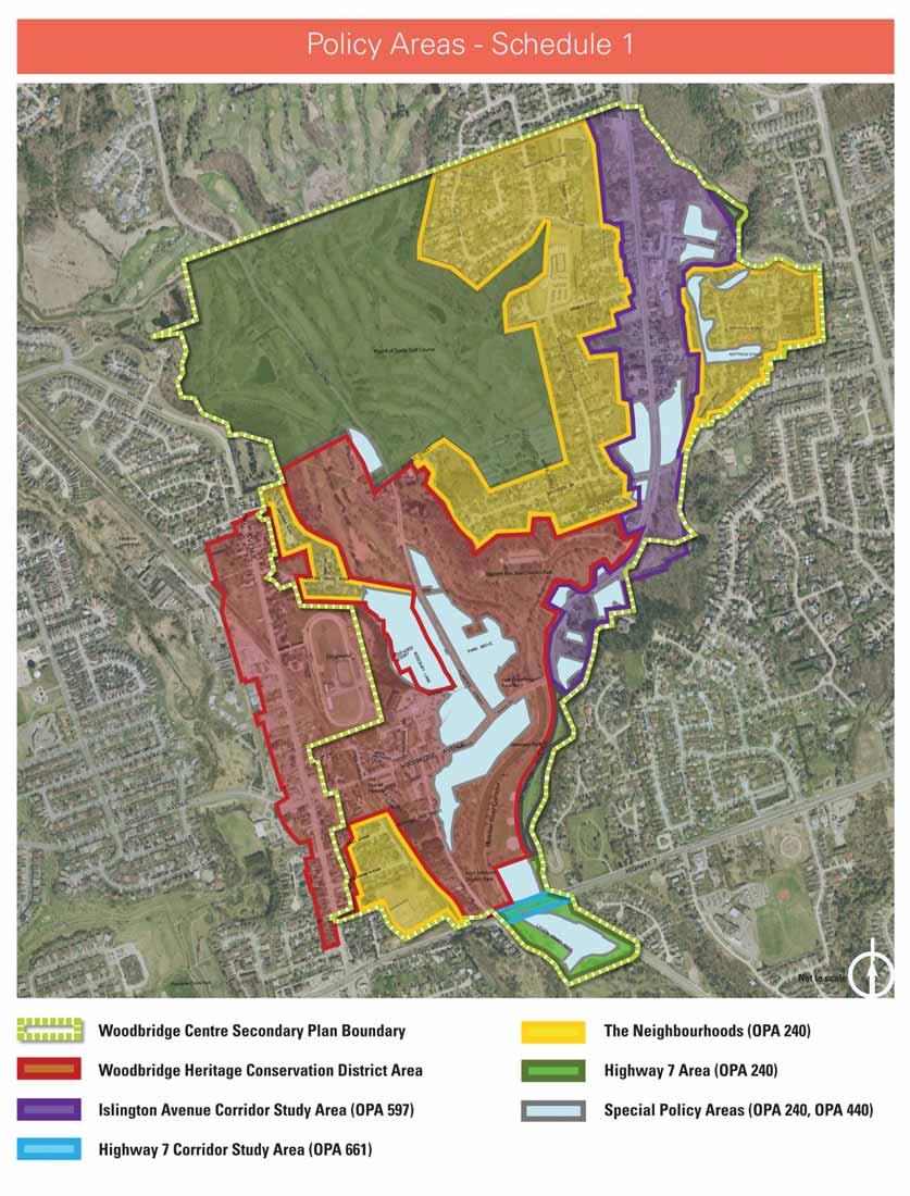
110
111 Land Use Plan - Schedule 2 7 VILLAGEWOOD COURT 9 CHAVENDER PLACE 9 RAINBOW DRIVE KIPLING AVENUE ELLERBY SQUARE N. 7 KIPLING AVENUE CORRIDOR SECONDARY PLAN PORTER AVENUE 11 AREA C.P.R.WOODBRIDGE FAIRGROUNDS 7 3 WILLIAM STREET MEETING HOUSE ROAD JAMES STREET 7 7 ABELL AVENUE CLADDAMOUR LANE FAIRGROUND CHELTENHAM AVENUE LANSDOWNE AVENUE BURWICK AVENUE BOARD OF TRADE GOLF COURSE 2 MOUNSEY STREET ROSEBURY LANE PLACE WALLACE STREET MEMORIAL HILL DRIVE C.P.R. 7 CLARENCE STREET ARBORS LANE WOODBRIDGE AVE. Protected Woodlot (See Part B - Section , Site Specific Policies, b,i.) FIRGLEN RIDGE 2 11 DORWOOD COURT PARK DRIVE 1 The Humber 1 River ISLINGTON 11 HIGHWAY 7 10 MARGARET MARY RD. LLOYD STREET WAYMAR HEIGHTS BOULEVARD DAVIDSON DRIVE AVENUE MONSHEEN DRIVE 8 TWILIGHT TERR. 9 WAKELIN COURT COURT AUTUMN RIDGE HAYHOE LANE 7 ROSLYN COURT GAMBLE STREET 8 THISTLEWOOD AVENUE HARTMAN AVENUE ISLINGTON AVENUE Legend PINE GROVE ROAD RIVERSIDE DRIVE BIRCH HILL ROAD NATTRESS STREET WILLIS ROAD Mid-Rise Mixed Use Mid-Rise Low Rise Mixed-Use Low Rise (3) Low Rise (2) Low Rise (1) Low Rise Gas Station Commercial Mixed Uses(1) Private Open Spaces Parks Natural Areas(Refer to Schedule 13-Q of Volume 1 of the City of Vaughan Official Plan for Natural Area mapping) Plan Boundary
112 THISTLEWOOD AVENUE ISLINGTON AVENUE Density Plan - Schedule 3 DORWOOD COURT MARGARET MARY RD. FIRGLEN RIDGE TWILIGHT TERR. COURT AUTUMN RIDGE HAYHOE LANE ROSLYN COURT PINE GROVE ROAD BOARD OF TRADE GOLF COURSE GAMBLE STREET WAYMAR HEIGHTS BOULEVARD BIRCH HILL ROAD HARTMAN AVENUE NATTRESS STREET RIVERSIDE DRIVE WILLIS ROAD MOUNSEY STREET CHAVENDER PLACE PLACE CLADDAMOUR LLOYD STREET DAVIDSON DRIVE WAKELIN COURT MEETING HOUSE ROAD KIPLING AVENUE CORRIDOR SECONDARY PLAN PORTER AVENUE ROSEBURY LANE CLARENCE STREET PARK DRIVE AREA C.P.R.WOODBRIDGE FAIRGROUNDS ARBORS LANE Legend VILLAGEWOOD COURT ELLERBY SQUARE N. RAINBOW DRIVE KIPLING AVENUE WILLIAM STREET JAMES STREET ABELL AVENUE LANE FAIRGROUND CHELTENHAM AVENUE LANSDOWNE AVENUE BURWICK AVENUE WALLACE STREET MEMORIAL HILL DRIVE WOODBRIDGE AVE. C.P.R. The Humber River ISLINGTON HIGHWAY 7 AVENUE MONSHEEN DRIVE Mid-Rise Mixed Use Mid-Rise Low Rise Mixed-Use Low Rise (3) Low Rise (2) Low Rise (1) Low Rise Gas Station Commercial Mixed Uses(1) Private Open Spaces Parks Natural Areas(Refer to Schedule 13-Q of Volume 1 of the City of Vaughan Official Plan for Natural Area mapping) Plan Boundary
113 Buiding Height Maximums - Schedule 4 FIRGLEN RIDGE DORWOOD COURT H2 MARGARET MARY RD. TWILIGHT TERR. COURT AUTUMN RIDGE HAYHOE LANE H2 H2 ROSLYN COURT H5 H3 PINE GROVE ROAD H2 H2 BOARD OF TRADE GOLF COURSE H2 GAMBLE STREET H3.5 H2 MOUNSEY STREET WAYMAR HEIGHTS BOULEVARD H2 H3.5 H5 HARTMAN AVENUE H3.5 H3.5 H5 ISLINGTON AVENUE RIVERSIDE DRIVE BIRCH HILL ROAD NATTRESS STREET WILLIS ROAD CHAVENDER PLACE PLACE CLADDAMOUR H2 LLOYD STREET DAVIDSON DRIVE WAKELIN COURT H2 MEETING HOUSE ROAD H2 KIPLING AVENUE CORRIDOR SECONDARY PLAN PORTER AVENUE ROSEBURY LANE H2 CLARENCE STREET PARK DRIVE H3.5 H2 THISTLEWOOD AVENUE H2 H3 AREA C.P.R.WOODBRIDGE FAIRGROUNDS VILLAGEWOOD COURT H4-6 H4-6 H2 H2 H4 KIPLING AVENUE WILLIAM STREET H3 JAMES STREET H4-6 ABELL AVENUE H2 LANE FAIRGROUND CHELTENHAM AVENUE WALLACE STREET MEMORIAL HILL DRIVE H3 H3 H4 H4-6 H6 H7 H6 H6 H4 C.P.R. ARBORS LANE WOODBRIDGE AVE. H4 H4 H3 H3 H3 The Humber River H2 ISLINGTON AVENUE H2 MONSHEEN DRIVE Legend 19m (6 storeys) 16m (5 storeys) 13m (4 storeys) 12m (3.5 storeys) 11m (3 storeys) 9.5m (2 storeys) ELLERBY SQUARE N. RAINBOW DRIVE LANSDOWNE AVENUE BURWICK AVENUE H2 HIGHWAY 7 H2 H2 Plan Boundary
114 Distinct Character Areas - Schedule 5 Ä Kiplin ton A venue Islington Avenue Corridor nue Isling g Ave ce ren Cla Kipling Avenue Corridor Secondary Plan Area eet Str Woodbridge Commercial Core (Local Centre) Wo rid odb Market Lane Area & Public Square ven ge A ue Legend Stable Neighbourhoods ay 7 w High Heritage Pockets Plan Boundary
115 Parks and Open Space Framework - Schedule ha a ha ha 50.98ha 0.60ha 0 h 0.60h 0.35haa 17.9ha ton A venue h haa h 0.18ha h.7 h 6.7ha 8.9ha 0.18h 0.18ha 18ha 0.18ha ha 40 0h 0ha 0 ha 0.40ha 0.19ha 9haa 0.08ha h haa eet Str 8.0ha ha 1h 1ha 0.81ha Kipling Avenue Corridor Secondary Plan Area 0.51ha 0 51ha 5 a ce ren Cla 1h 0.31ha Isling 12.5ha 0.26ha h 0.20ha ha 0.23ha 0.23h 23h 23h ha 0.14ha.14h 14ha 14 1 haa h nu Ave 0.04ha h 4 haa h d Woo brid ge e 3.57ha ha 0 7ha Kiplin g Ave 1.08ha h 8 ha ha nue Legend way High ha Woodbridge Centre Secondary Plan Boundary Parks Private Open Space Public Square - 2.4ha Cemetery Neighborhood Park ha Fairgrounds District Park ha Golf Course Open Space Valley Lands and Neighbouring Parks
116 Islington Avenue Pedestrian and Bicycle Trails Network - Schedule 7 ce ren Cla eet Str Kiplin g Ave nue dbri Woo dge n Ave ue way High 7 Legend Woodbridge Centre Secondary Plan Boundary Approved (On Road Trails) Approved Multi Use Trails Proposed Multi UseTrails Proposed (On Road Trails) Multi Use Trail Heads Road Trail Heads Note * Approved Trails Include: OPA 695 Trails Network WHCD Trails Network City of Vaughan Pedestrian and Bike Trails Master Plan OPA 597 Trails Network
117 Street Network, Nodes and Gateways - Schedule 8 Islington Ave. Pine Grov e Roa d en ar Cl ce. St. s illi Rd W r. C. son D ail P. R David Meetin g Hous e Rd. ve. Kipling A c Walla e. ge Av brid Wood e Str eet Legend.7 Hwy Woodbridge Centre Secondary Plan Boundary Primary Gateway Major Arterial Local Road Major Collector C.P. Rail Corridor Minor Collector Secondary Gateway Pedestrian Priority Node
118 THISTLEWOOD AVENUE ISLINGTON AVENUE Special Policy Area - Schedule 9 DORWOOD COURT MARGARET MARY RD. FIRGLEN RIDGE TWILIGHT TERR. COURT AUTUMN RIDGE HAYHOE LANE ROSLYN COURT PINE GROVE ROAD BOARD OF TRADE GOLF COURSE GAMBLE STREET WAYMAR HEIGHTS BOULEVARD BIRCH HILL ROAD HARTMAN AVENUE NATTRESS STREET RIVERSIDE DRIVE WILLIS ROAD MOUNSEY STREET CHAVENDER PLACE PLACE CLADDAMOUR LLOYD STREET DAVIDSON DRIVE WAKELIN COURT MEETING HOUSE ROAD KIPLING AVENUE CORRIDOR SECONDARY PLAN PORTER AVENUE AREA C.P.R.WOODBRIDGE FAIRGROUNDS ROSEBURY LANE CLARENCE STREET PARK DRIVE ARBORS LANE VILLAGEWOOD COURT KIPLING AVENUE WILLIAM STREET JAMES STREET ABELL AVENUE LANE FAIRGROUND CHELTENHAM AVENUE WOODBRIDGE AVENUE WALLACE STREET MEMORIAL HILL DRIVE The Humber River ISLINGTON AVENUE MONSHEEN DRIVE Legend Special Policy Area Plan Boundary C.P.R. ELLERBY SQUARE N. LANSDOWNE AVENUE BURWICK AVENUE HIGHWAY 7 RAINBOW DRIVE
119 Tracking Matrix of Modifications to the SPA Justification Report and Woodbridge Centre Secondary Plan in Response to the Province s One-Window Comments of December 17, Item Document 1. SPA Justification Report Package Issue (Identified in the Province s one-window comments of December 17, 2013) SPA boundary modifications based on most recent TRCA floodline assessment and mapping. TRCA to provide signed and embossed updated floodline mapping for the subject area. TRCA must provide a signed letter from a TRCA Professional Engineer indicating the justification and acceptance of the updated mapping. Staff Comment Staff contacted TRCA to confirm that required documents are forthcoming. City Response TRCA contacted the City to indicate that the signed and embossed updated floodline mapping has been sent to the Ministry of Natural Resources. 2. SPA Justification Report The Province agrees that 355 additional residential units directed to the SPA in the Woodbridge Commercial Core (SPA # 9a2, #9a3, #9a4) is reasonable, however the City must demonstrate safe access for pedestrians and vehicles is achievable for these areas. Staff reviewed safe access provisions in the Secondary Plan and the SPA Justification Report in relation to the subject areas in the Woodbridge Commercial Core. Vaughan Emergency Planning Department and MNR/MMAH consulted and provided comment on additional content related to safe access. Additional explanation of safe access in subject areas (SPA # 9a2, 9a3, 9a4) and reference to the safe access requirements of the Woodbridge Centre Secondary Plan is provided in the Emergency Management Plan (section 2.0) of the SPA Justification Report. Section 6.0, Summary of Flood Risk of the SPA Justification Report is revised to demonstrate areas of vehicular access (i.e. safe access) and pedestrian access (i.e low risk areas) through mapping of the parcels in the Woodbridge Commercial Core. ATTACHMENT 2
120 Item Document 3. Woodbridge Centre Secondary Plan Issue (Identified in the Province s one-window comments of December 17, 2013) Appendix 1: Technical Comments # 9-19 outline required edits of the Woodbridge Centre Secondary Plan as requested by MMAH/MNR. Staff Comment Staff consulted on revisions with Development Planning Division. TRCA consulted and provided wording regarding specific sections. City Response Revisions to the SPA policies in section of the Woodbridge Centre Secondary Plan have been made as recommended by MMAH/MNR. 4. SPA Justification Report Package By-Law 1-88 Due to the delay which is expected to occur between approval of the new secondary plan affecting the Woodbridge SPA and revising the comprehensive zoning by-law, an interim approach until such time as the comprehensive zoning by-law can be updated is required. In consultation with Development Planning Division, City staff reviewed By-law 1-88 and the Woodbridge Centre Secondary Plan, and further refined the list of sites where building permissions and/or overnight accommodation are greater than the provisions in the Secondary Plan. A draft amendment to By-law 1-88 is included in the SPA Report Package and is Attachment 4 to the staff report for Committee of the Whole, April 29, Development Planning staff were also consulted in drafting the amendment to By-law 1-88.
121 Item Document 5. SPA Justification Report Issue (Identified in the Province s one-window comments of December 17, 2013) The Province requires an emergency response plan prepared by the Emergency Planning Department which demonstrates how all relevant resources and services (e.g. police, ambulance and fire), including equipment, are coordinated to response appropriately to a flood or fire emergency associated with the existing and proposed development within the Woodbridge SPA. Staff Comment Staff reviewed the City of Vaughan s internal Emergency Management policies and consulted with Emergency Planning Department staff. Draft responses to the onewindow comments were reviewed by MMAH and MNR staff in advance of the SPA Report Package submission. City Response Section 2.0, Emergency Management Plan, of the SPA Justification Report has been revised to the satisfaction of the MNR. A letter, comprising Attachment 5 to the staff report for Committee of the Whole, April 29, 2014, submitted by the Emergency Planning Department explains the City of Vaughan Emergency Planning policies and confirms the compliance of these internal policies with current provincial legislation regarding Emergency Planning. The SPA Report Package includes a transmittal letter signed by the Fire Chief of the City of Vaughan.
122 Item Document 6. SPA Justification Report Issue (Identified in the Province s one-window comments of December 17, 2013) Consolidate requested documents. Staff Comment Policy Staff consolidated the requested document. City Response The final SPA Report Package includes the: - Transmittal letter signed by the Commissioner of Planning and the Fire Chief; - staff report for Committee of the Whole, April 29, 2014; - resulting Council minute; - Woodbridge Centre Secondary Plan; - Special Policy Area Justification Report for the Woodbridge Centre Secondary Plan; - draft Zoning By-law Amendment; and - additional attachments to the staff report including a matrix tracking the response to the Province s onewindow comments. Overall Comments Appendix # 1: Technical Comments Document Issue City Action City Response 1. SPA Justification Report With respect to the additional residential units directed to the Woodbridge Commercial Core and including the SPA, the Province requests that the City Policy changes have been addressed through requirement for emergency plans, floodproofing and pedestrian and vehicular Policy changes are addressed by the responses in No. 2 and No. 5 above regarding safe access and emergency management. TRCA advised that no additional remedial measures are
123 Item Document Issue (Identified in the Province s one-window comments of December 17, 2013) explain any remedial measures or policy changes to reduce risk to meet Provincial requirements. Staff Comment access. The City consulted with TRCA regarding the issue of remedial measures. City Response required. 2. SPA Justification Report The flood risk assessment must be updated to incorporate the current land use as described in the Woodbridge Centre Secondary Plan. An updated flood risk assessment was prepared by the City as a revision to Section 6 of the SPA Justification Report, The revised risk assessment was shared with MMAH and MNR to confirm the structure and content of the information. Section 6 of the SPA Justification Report includes a revised flood risk assessment with a focus on the proposed designations in the Woodbridge Centre Secondary Plan for the Woodbridge Commercial Core and clearly illustrating areas of safe access. Specific Comments 1. SPA Justification Report The Executive Summary should include a table showing the overall dwelling unit changes and land use change within the SPA. The City agrees with the recommendation. The Executive Summary of the SPA Justification Report has been updated to include a summary of the main land use changes from previous approved Official Plan Amendments to the Woodbridge Centre Secondary Plan and a summary table of the expected residential build-out (summarized from Section 6) as provided for in approved Official Plan Amendments as compared to the Woodbridge Centre Secondary Plan.
124 Item Document 2. SPA Justification Report 3. SPA Justification Report Issue (Identified in the Province s one-window comments of December 17, 2013) Section 5.1 of the SPA Report should include a status update of the comprehensive hydrological modeling of the Humber River, as undertaken by the TRCA. The City should explain why approved permits meet the lower level of flood protection, rather than the highest level technically practical or feasible as per provincial requirements. Staff Comment City staff contacted the TRCA to confirm the status of the hydrological modeling. City staff contacted the TRCA to provide a summary statement regarding the floodproofing standard achieved in approved permits. City Response A status update has been included in Appendix G: The TRCA is currently undertaking a comprehensive update to the hydrologic modelling of the Humber River, anticipated to be completed in Pending the outcome of this work, there may be a future update of the hydraulic modelling of the Humber River. Item #3 pertaining to Land Use Planning Functioning of the SPA in Section ( Information Requirements for SPA Modifications and Land Use Changes ) of the SPA Justification Report notes that permits recently approved by the TRCA in the Woodbridge core demonstrates that floodproofing to the Regulatory Flood level is being achieved. The updated policy on floodproofing, e) has been strengthened such that proponents must strive to achieve the highest level of flood protection. 4. SPA Report The Table in Section regarding the SPA policies in the Woodbridge Centre Secondary Plan describes the safe access requirements in the SPA Policies of Section However, the safe access should extend to all people and vehicles. The City agrees with the recommendation from the province to refer to all pedestrian and vehicular traffic. Policy 7.3.2c) of the Woodbridge Centre Secondary Plan regarding ingress/egress and safe access now refers to all pedestrian and vehicular traffic. Section of the SPA Report reflects this change to the policies of Section of the Secondary Plan.
125 Item Document Issue (Identified in the Province s one-window comments of December 17, 2013) 5. SPA Report Appendix D demonstrates the SPA boundaries, however, these appear to be out of date. 6. SPA Report Parcel #8045 Islington Ave. is located within a High Risk area, and is designated Private Open Space in App. I, however App. H designates this parcel as Low- Rise. 7.a) SPA Report The Flood Risk Assessment should be based on the most recent SPA boundary mapping. Staff Comment Appendix D was not updated in the revised SPA Justification Report delivered to the Province in March 2013 pending possible changes to the SPA boundaries following the Province s review Islington Avenue is designated Low-Rise in the Woodbridge Centre Secondary Plan and is in the proposed SPA. The designation reflects the approved designation in OPA 240 for Church use. The parcel immediately to the west at 8025 Islington Avenue is designated Private Open Space to reflect the Open Space 2 (OS2) zone to permit the existing cemetery use. The parcel at 8025 Islington Avenue is outside of the floodline. Rather than revising Appendix G, the City and the Province agreed that the City update Section 6 of the SPA Justification Report to provide a flood risk assessment with a City Response Appendix D is updated to include a summary map of additions and deletions to the SPA boundaries and a summary table quantifying the areal extent of additions and deletions for each of the 10 SPA sub-areas. Appendix H of the SPA Justification Report includes the correct designations for 8045 Islington (in the SPA) and 8025 Islington Avenue (removed from the SPA). The schedules in the Woodbridge Centre Secondary Plan are correct with respect to these parcels. Section 6 of the SPA Justification Report includes a flood risk assessment with a focus on the proposed SPA boundaries and designations in the Woodbridge Centre Secondary Plan. The revised flood risk assessment also has a focus on the
126 Item Document Issue (Identified in the Province s one-window comments of December 17, 2013) Staff Comment focus on the proposed SPA boundaries and designations in the Woodbridge Centre Secondary Plan. City Response Woodbridge Commercial Core area (SPA sub-areas #9a2, #9a3 and #9a4) illustrating the areas of safe access (<0.3 metres flood depth), low risk and high risk parts of the SPA in accordance with the Natural Hazards Technical Guide. 7.b) SPA Report The most recent TRCA Flood risk mapping identifies 0.3m, 0.8m and 1.2m as Low and High Risk thresholds. App G. Flood Risk Assessment must reflect these values. 7.c) SPA Report MNR Flood Hazard Limit Guidelines requires ingress and egress for pedestrian and vehicular traffic under emergency conditions. The City and the Province agreed to revise the flood risk assessment in Section 6 of the SPA Justification Report and include a focus on the Woodbridge Commercial Core area (SPA sub-areas #9a2, #9a3 and #9a4) illustrating the areas of safe access (<0.3 metres flood depth), low risk and high risk parts of the SPA in accordance with the Natural Hazards Technical Guide. The City and the Province agreed to revise the flood risk assessment in Section 6 of the SPA Justification Report and include a focus on the Woodbridge Commercial Core area (SPA sub-areas #9a2, #9a3 and #9a4), where additional dwelling units are provided in the Secondary Plan, illustrating the areas of Section 6 of the SPA Justification Report has been revised accordingly. Maps of the Woodbridge Commercial Core are included that illustrate areas of safe access, low risk and high risk. These maps can be cross-referenced to tables indicating areas of potential residential redevelopment in the SPA in the Woodbridge Commercial Core. Section 6 of the SPA Justification Report has been revised accordingly. Maps of the Woodbridge Commercial Core are included that illustrate areas of safe access, low risk and high risk. These maps can be cross-referenced to tables indicating areas of potential residential redevelopment in the SPA in the Woodbridge Commercial Core.
127 Item Document Issue (Identified in the Province s one-window comments of December 17, 2013) Staff Comment safe access (<0.3 metres flood depth), low risk and high risk parts of the SPA in accordance with the Natural Hazards Technical Guide. City Response 7.d) SPA Report Flood Risk and property damage estimations in the revised Flood Risk assessment should reflect the SPA changes outlined in the Woodbridge Centre Secondary Plan. 7.e (i) SPA Report To support the Flood Risk Assessment, the following should be provided in a separate appendix; - existing and proposed SPA condition; - clearly showing areas of safe access, low risk and high risk for SPA sub-areas #9a2, #9a3 and #9a4; and - reference to the 2007 Flood Damage Estimation Guide. The City agrees that additional information is required to describe the estimated damage costs in Table 6-3 of the revised SPA Justification Report. The City and Province agreed to address these issues in the revised flood risk assessment in Section 6 of the SPA Justification Report, rather than in an appendix. Section 6 of the SPA Justification Report has been revised accordingly. Maps of the Woodbridge Commercial Core are included that illustrate areas of safe access, low risk and high risk. These maps can be cross-referenced to tables indicating areas of potential residential redevelopment in the SPA in the Woodbridge Commercial Core. Section 6 of the SPA Justification Report has been revised accordingly, with the noted items addressed in subsection 6.2 and subsection 6.3. Maps of the Woodbridge Commercial Core are included that illustrate areas of safe access, low risk and high risk. These maps can be cross-referenced to tables indicating areas of potential residential redevelopment in the SPA in the Woodbridge Commercial Core. 7.e) (ii) SPA Report The floodplain boundary has changed, eliminating lands at risk. Therefore, a new map is required that shows an updated Several map products were provided in the City s March 2013 response to the Province s additional Map products are incorporated into Sections 5 and 6 of the revised SPA Justification Report to illustrate the floodline in relation to the existing and
128 Item Document Issue (Identified in the Province s one-window comments of December 17, 2013) floodline and existing SPA boundaries. Staff Comment information request that address the issue. These map products are incorporated into the revised SPA Justification Report. City Response proposed SPA boundaries. 7.f) SPA Report The Technical Bullets in App. G should be included in a revised Flood Risk Assessment, as well as TRCA confirmation that lands removed from the SPA are subject to other floodplain management techniques. 7.g) SPA Report Section 3.3 of App. G should consider safe access for all people and vehicles in the flood risk analysis. VFRS should be clarified. The City and the Province agreed that the technical requirements listed in the Procedures for the Approval of New Special Policy Areas (SPAs) and Modifications to Existing SPAs Under the Provincial Policy Statement 2005 (PPS, 2005), Policy Natural Hazards Special Policy Areas (MNR 2009) are provided in Section 5 of the SPA Justification Report. The City and the Province agreed to revise the flood risk assessment in Section 6 of the SPA Justification Report and include a focus on the Woodbridge Commercial Core area (SPA sub-areas #9a2, #9a3 and #9a4), where additional dwelling units are provided in the Secondary Plan, illustrating the areas of safe access (<0.3 metres flood depth), low risk and high risk No changes are necessary. Section 6 of the SPA Justification Report has been revised accordingly. The term VFRS (Vaughan Fire and Rescue Service) has been clarified in Appendix G.
129 Item Document Issue (Identified in the Province s one-window comments of December 17, 2013) Staff Comment parts of the SPA in accordance with the Natural Hazards Technical Guide. City Response 8. Additional Information Request Item L of the Additional Information Request describes other floodplain management approaches as not required, however this should read is not a feasible option. A statement regarding the feasibility of other floodplain management approaches is also required in the SPA Report. Staff contacted the TRCA regarding the feasibility of alternative floodplain management approaches. The response from the TRCA addresses the Two Zone concept and the SPA concept. This is included as a new section (section 5.3) in Appendix G. 9. Woodbridge Centre Secondary Plan The Secondary Plan (Part B f, 8.3.a) prescribes below grade parking for the Woodbridge Commercial Core, however, this type of parking construction is discouraged in the SPA. The City must provide a notwithstanding clause in Section 7.3 to prohibit below grade parking or prescribing its construction to Regulatory Flood level access. Staff reviewed identified sections of the Secondary Plan and given the existing presence of below grade parking structures in the area, recommended a conditional policy to allow below grade parking if access above the Regulatory Flood level is achieved. Staff contacted TRCA to confirm approach and provide wording. Section f) has been revised as recommended by the TRCA, as follows: Underground parking is generally discouraged within the Special Policy Area. Where an underground parking garage is proposed, it shall be floodproofed to the Regulatory Flood elevation. Where it is technically impractical to floodproof to the Regulatory Flood level, the entrance and all openings, including those associated with ventilation, shall be floodproofed to the highest level technically feasible and practical, as determined by the City and the Toronto and Region Conservation Authority. The minimum floodproofing shall be the 1:350 year flood level, as determined by the Toronto and Region Conservation Authority.
130 Item Document Issue (Identified in the Province s one-window comments of December 17, 2013) Staff Comment City Response 10. Secondary Plan Section c) indicates that Woodbridge Ave is designated Low-Rise Mixed- Use, while Attachment 4 of the City s March 2013 response to the Province indicates an OPA and rezoning application was withdrawn. However, the subject lands are also in the area of High Risk. Staff reviewed the subject area in relation to the land use schedule (2) of the Secondary Plan and most recent High/Low Flood Risk Analysis and determined the parcel to be located in the Low Risk portion of the SPA with safe access. No change recommended to the land use designation policies of the Secondary Plan Section c). This site-specific policy addresses a height maximum, which can be achieved provided that the proposed development is in conformity with the Woodbridge Heritage Conservation District Plan, but does not provide for an increase in density beyond that specified on Schedule 3 (Density Plan). 11. Secondary Plan Section should include the word unacceptable after the phrase protect the public from. Staff reviewed the identified section of the SPA Policies (Section 7.3.2) contained in the Secondary Plan and inserted the word unacceptable. The first paragraph of Section has been revised as recommended by the Province, as follows: Development within the Special Policy Area is permitted in accordance with the land use designations on Schedule 2 and related policies of Part B Section 4 of this Plan, subject to the following criteria, which are intended to protect the public from unacceptable risks associated with flooding: 12. Secondary Plan Section b) should include new before residential apartment building and commercial/institutional. Staff reviewed the identified section of the SPA Policies (Section 7.3.2) contained in the Secondary Plan and inserted the words new and commercial/institutional. Section b) has been revised as recommended by the Province, as follows: For any new residential apartment building and/or commercial/institutional building, the
131 Item Document Issue (Identified in the Province s one-window comments of December 17, 2013) Staff Comment City Response applicant shall provide an emergency response plan, prepared by a qualified professional, as part of the development application, in accordance with emergency management standards and practices. 13. Secondary Plan Section c) includes the phrase buildings should, however, this should be changes to new buildings shall. Emergency vehicles should be changed to all pedestrian and vehicular traffic. Staff reviewed the identified section of the SPA Policies (Section 7.3.2) contained in the Secondary Plan and inserted the words new buildings shall and all pedestrian and vehicular traffic. Staff also consulted with MNR/MMAH regarding this section and received replacement phrasing. MNR/MMAH also provided additional definitions. TRCA reviewed the recommended text from the Province and suggested a minor change to recognize existing permissions for redevelopment in parts of the SPA that would not result in additional dwelling units. Section c) has been revised as recommended by the Province and in consultation with the TRCA, as follows: Safe pedestrian movement and safe vehicular access and egress for all new buildings shall be provided pursuant to the Provincial flood proofing standards, or achieve the highest level of flood protection determined to be practical by the Toronto and Region Conservation Authority in consultation with the City. More specifically, at a minimum, safe pedestrian movement shall be required for all new buildings that provide overnight accommodation and/or for any redevelopment where an increase in the number of units that provide overnight accommodation is proposed. Wherever possible, dry pedestrian access is preferred. The following definitions are added to Part C Definitions and Schedules: Safe Pedestrian Movement May be achieved where product depths and velocities do not exceed 0.371m squared per second and the depth does not exceed 0.8m and the velocity does not exceed 1.7m/s.
132 Item Document Issue (Identified in the Province s one-window comments of December 17, 2013) Staff Comment City Response Safe Vehicular Access and Egress May be achieved where the depth of flooding does not exceed m. 14. Secondary Plan In Section e), the words practical, reasonable and desirable from an urban design perspective should be changed to technically feasible and practical. The last sentence should be deleted in its entirety. Staff reviewed the identified section of the SPA Policies (Section e) and inserted the words technically feasible and practical and eliminated the last sentence. The City agrees that meeting a floodproofing standard that is technically feasible and practical allows for the flexibility to promote retail uses at grade. Section e) has been revised as recommended by the Province, as follows: Dry floodproofing shall be required to the level of the Regulatory Flood, plus a free board as determined by the Toronto and Region Conservation Authority. Where it is technically impractical to floodproof to the Regulatory Flood Level, a level of flood protection between the Regulatory Flood and the 1:350 year Flood Level may be permitted as determined by the City and the Toronto and Region Conservation Authority to be the required flood level. Efforts must be made to strive for the highest level of flood protection between the Regulatory Flood Level and the 1:350 year Flood Level determined by the Toronto and Region Conservation Authority and the City to be technically feasible and practical. 15. Secondary Plan Section h) ii) should include the words electrical wiring, fuse boxes, furnaces, air conditioning, elevators, etc. after habitable floor space elevation and replace required flood level with Regulatory Staff reviewed the identified section of the SPA Policies (Section h) ii) and inserted the words electrical wiring, fuse boxes, furnaces, air conditioning, elevators, etc. and Regulatory Storm Section h) ii) has been revised as recommended by the Province, as follows: Upon completion of any foundation, the City and the Toronto and Region Conservation Authority will require a certificate from an Ontario land surveyor or a professional
133 Item Document Issue (Identified in the Staff Comment City Response Province s one-window comments of December 17, 2013) Storm level. level. engineer, verifying that the habitable floor space elevation, electrical wiring, fuse boxes, furnaces, air conditioning, elevators, etc. are located above the Regulatory Flood level, prior to issuance of the building permit. 16. Secondary Plan Section d) should replace the words The development will be isolated with the words Safe access for all people and vehicles cannot be achieved. Staff reviewed the identified section of the SPA Policies (Section d) and inserted the words Safe access for all people and vehicles cannot be achieved. Section d) has been revised as recommended by the Province, as follows: Safe access for all people and vehicles cannot be achieved during the flood conditions because roads and escape routes are not passable. 17. Secondary Plan Section should include the words Except for all policies that are relevant to the Woodbridge SPA at the beginning of the section. Staff reviewed the identified section of the SPA Policies (Section 9.0.5) and inserted the words Except for all policies that are relevant to the Woodbridge SPA. At the recommendation of the TRCA, the text including additions or alterations has been removed from policy to recognize existing permissions for redevelopment in the SPA that does not result in new dwelling units. Section has been revised as recommended by the Province, as follows: Except for all policies that are relevant to the Woodbridge SPA, where any of the policies of this Secondary Plan conflict with policies set out in the Woodbridge Heritage Conservation District Plan (WHCD Plan), the policies of the WHCD Plan shall prevail. 18. Secondary Plan The Secondary Plan must include a policy that requires the City to update Comprehensive Staff agree that By-law 1-88 requires updating in order to implement the SPA policies of It is recognized in the Committee of the Whole Staff Report April 29 th, 2014, that By-law 1-88 shall be updated in
134 Item Document Issue (Identified in the Province s one-window comments of December 17, 2013) Zoning By-law 1-88 to implement the updated SPA policies. Staff Comment the Secondary Plan, however, this recommendation is included in the SPA Staff Report. City Response accordance with the Planning Act. 19. Secondary Plan The Low-Rise (2) designation Section e), contains a notwithstanding clause that restricts the use of density bonusing if an area falls within an SPA. The Province recommends extending this policy to all designations for lands within the SPA. The City agrees with the suggestion that density bonusing should not be permitted in the SPA. An additional notwithstanding clause regarding the use of density bonsuing has been added to the SPA Policies. A policy has been added as l) to address the recommendation from the Province, as follows: A density bonus is not permitted for properties in any land use designation in the Special Policy Area.
135 ATTACHMENT 3 Special Policy Area Justification Report for the Woodbridge Centre Secondary Plan April 2014 Prepared by: City of Vaughan (Policy Planning, Emergency Planning, Development Planning, Information and Technology Management, and Development/Transportation Engineering)
136 Woodbridge Special Policy Area Justification Report. April Table of Contents Executive Summary Introduction Purpose and Scope of the Study Land Use Context Policy Context Public Process City of Vaughan Emergency Management Plan Geographic Risk Operational Risk Pillars of Emergency Management Emergency Management and the Woodbridge Centre Secondary Plan History of SPA Policies Official Plan Amendment and Zoning By-Law Summary for SPA Parcels Special Policy Area Boundary Adjustments and Policy Modifications Technical Information Regarding Boundary Adjustments Land Use Planning Information Requirements Information Requirements for SPA Policy Modifications and Land Use 28 Changes 6.0 Summary of Flood Risk Summary of Flood Risk Assessment and Main Recommendations Flood Risk Assessment Designations in the Woodbridge Centre 39 Secondary Plan 6.3 Overall Changes in Dwelling Units in the SPA Summary of Operational Risk and Emergency Preparedness Recommended Land Use Plan and SPA Policies Implementation References 61 List of Appendices Appendix A Terms of Reference for the Woodbridge Focused Area Study Appendix B Summary of Special Policy Area Policies Appendix C Parcel Zoning and Designations in the Special Policy Area Appendix D Parcel-level Special Policy Area Boundary Modifications Appendix E Capacity Assessment Results Appendix F Capacity Assessment Methodology Appendix G Flood Risk Assessment Appendix H Parcel Designations in the Special Policy Area for the Woodbridge Centre Secondary Plan Appendix I Summary of Proposed Changes to SPA Policies and Land Use Designations Appendix J Existing Approved SPA Policies as Provided in Volume 1 of the City of Vaughan Official Plan (Council-Adopted September 2010) Prepared by City of Vaughan (Policy Planning, Emergency Planning, Development Planning, Information and Technology Management, and Development Engineering) 2
137 Woodbridge Special Policy Area Justification Report. April List of Figures Figure 1-1 Figure 1-2 Existing SPA boundaries in the Woodbridge Area. Number codes are for the purposes of the flood risk assessment. Outer boundary defines the study area for the Woodbridge Focused Area Study. Plan area and land use for OPA 695, the Kipling Avenue Corridor Plan Figure 1-3 Woodbridge Core area as shown on Schedule I of OPA Figure 1-4 Figure 5-1 Figure 5-2 Woodbridge Core and land use as shown in Schedule B of OPA 240. Existing and proposed Special Policy Area (SPA) in relation to the flood depths, at 1 metre intervals, from a Regulatory Flood event. Prepared By: TRCA. Data Source: TRCA, Existing and proposed Special Policy Area (SPA) in relation to flow velocities from a Regulatory Flood event. Prepared By: TRCA. Data Source: TRCA, Figure 5-3 Existing SPA in relation to property boundaries and current zoning 35 Figure 5-4 Figure 6-1 Figure 6-2 Figure 6-3 Figure 6-4a Figure 6-4b Proposed SPA in relation to property boundaries and current zoning Thematic depiction of risk to life thresholds in the Natural Hazards Technical Guides. Areas of low risk are defined as areas where the product of depth and velocity is less than 0.37 m 2 /s providing that depth does not exceed 0.8 m and that the velocity does not exceed 1.2 m/s. Existing SPA in relation to land use designations in the Woodbridge Centre Secondary Plan Proposed SPA in relation to land use designations in the Woodbridge Centre Secondary Plan Street addresses for parcels on the north side of Woodbridge Avenue. NW corner of Woodbridge Avenue and Clarence Street is SPA sub-area #9a2. NE corner of Woodbridge Avenue and Clarence Street is SPA sub-area #9a4. Street addresses for parcels on the south side of Woodbridge Avenue located in SPA sub-area #9a Prepared by City of Vaughan (Policy Planning, Emergency Planning, Development Planning, Information and Technology Management, and Development Engineering) 3
138 Woodbridge Special Policy Area Justification Report. April Figure 6-5 Figure 6-6 Figure 6-7 Area of safe access (hatched area: < 0.3 metres flood depth during a Regulatory Flood event) in the Woodbridge Commercial Core (SPA sub-areas #9a2, #9a3 and #9a4) in relation to the land use designations in the Woodbridge Centre Secondary Plan. Low risk part of the SPA in the Woodbridge Commercial Core (SPA sub-areas #9a2, #9a3 and #9a4) in relation to the land use designations in the Woodbridge Centre Secondary Plan. High risk part of the SPA in the Woodbridge Commercial Core (SPA sub-areas #9a2, #9a3 and #9a4) in relation to the land use designations in the Woodbridge Centre Secondary Plan List of Tables Table 6-1 Table 6-2a Table 6-2b Table 6-3 Comparison of existing and approved dwelling units for the existing and proposed Woodbridge Special Policy Area. Comparison of estimated dwelling unit counts for potential redevelopment parcels in SPA #9a2 provided for in current approved policy (i.e. OPA 440) and in the Woodbridge Centre Secondary Plan. Commercial floor area is estimated at 10% of gross floor area (GFA) for Mid-Rise Mixed-Use and Mid-Rise designations to arrive at dwelling unit counts provided for in the Woodbridge Centre Secondary Plan. Comparison of estimated dwelling unit counts for potential redevelopment parcels in SPA #9a3 and SPA #9a4 provided for in current approved policy (i.e. OPA 440) and in the Woodbridge Centre Secondary Plan. Commercial floor area is estimated at 10% of gross floor area (GFA) for Mid-Rise Mixed-Use and Mid-Rise designations to arrive at dwelling unit counts provided for in the Woodbridge Centre Secondary Plan. Summary of change in residential dwelling units, estimated population, and damage costs based on changes to SPA boundaries and land use designations in the Woodbridge Centre Secondary Plan Table 6-4 Estimated private property repair costs from flood damage 57 Prepared by City of Vaughan (Policy Planning, Emergency Planning, Development Planning, Information and Technology Management, and Development Engineering) 4
139 Woodbridge Special Policy Area Justification Report. April Executive Summary A comprehensive Special Policy Area (SPA) review has been undertaken by the City of Vaughan in cooperation with the Toronto and Region Conservation Authority (TRCA) and the Province of Ontario. The SPA review is a component of the Woodbridge Focused Area Study, a product of which has been the Woodbridge Centre Secondary Plan. The Secondary Plan is one of five new secondary plans in Volume 2 of the new City of Vaughan Official Plan (VOP 2010, adopted by the Council of the City of Vaughan in September 2010). City-wide policies comprise Volume 1 of the new City of Vaughan Official Plan. The Woodbridge Centre Secondary Plan includes the proposed SPA boundaries, revised land use designations affecting the SPA, land use policies and SPA policies. Direction to undertake the comprehensive SPA review is provided in three primary policy documents: Section 3 of the Provincial Policy Statement (PPS) and relevant parts of the Definitions section regarding SPAs; The recent Procedures for the Approval of New Special Policy Areas (SPAs) and Modifications to Existing SPAs Under the Provincial Policy Statement 2005 (PPS, 2005), Policy Natural Hazards Special Policy Areas (MNR 2009); and The Terms of Reference specific to the study (see Appendix A). The two main components of the SPA review are (1) undertaking a review of the SPA boundary, land use and policies, and (2) a flood risk assessment. The risk assessment was undertaken within the context of the City-wide Emergency Management Plan and considered aspects of geographic risk (i.e. avoiding risk) and operational risk (i.e. hazard response). Summary of SPA Boundary and Land Use Policy Changes The proposed SPA boundaries result largely from an update of the floodplain modelling provided by the TRCA. The minor adjustments proposed to the existing SPA boundaries as set out in the Woodbridge Centre Secondary Plan are a result of the following changes, which results in a decrease of the overall SPA area from 40.1 hectares to 29.8 hectares. Parcels designated Natural Areas, including property owned by TRCA, are removed from the SPA as development is not intended to occur on these lands. Parcels designated Parks in SPA #1 are removed from the SPA as development is not intended to occur on these lands, although the proposed SPA boundary includes the long-standing structures (e.g. concrete silos) of the former Hayhoe Mills site if it is determined that these structures can be re-used for ancillary park uses. The Park designation for a public square in the Market Lane area is not removed from the SPA as the precise location of the public square is not yet determined. Lands located inside the previous regulatory floodplain but outside of the updated floodplain were removed from the SPA as development is no longer restricted by provincial or TRCA floodplain management policy in these areas, though they still remain subject to TRCA s Regulation (Ontario Regulation 166/06). New boundaries follow property lines, where applicable, such that select properties no longer straddle the boundary between the SPA and the one-zone floodplain area. Prepared by City of Vaughan (Policy Planning, Emergency Planning, Development Planning, Information and Technology Management, and Development Engineering) 5
140 Woodbridge Special Policy Area Justification Report. April The SPA policies from previous Official Plan Amendments are largely brought forward in the Council-adopted (September 2010) Woodbridge Centre Secondary Plan. Recommended changes to the SPA policies in Section 7.3 of the Woodbridge Centre Secondary Plan as a result of the SPA review and in response to the Province s comments of December 17, 2013 can be summarized as follows: Given the TRCA mandate under Regulation 166/06 for the management of floodplain lands and river valleys, any action taken as a result of development applications within the TRCA regulated area shall be to the satisfaction of the TRCA rather than in consultation with the TRCA. The floodproofing standard is specified in one clear policy. This is consistent with the policy in OPA 440, but replaces suggested policies in the Council-adopted (September 2010) Secondary Plan in which floodproofing standards varied for several different designations. Given that the Low-Rise designation permits townhouse development (see policy c in Volume 1 of VOP 2010), notwithstanding policies are added to ensure that single-detached units are not converted to townhouse developments in the Low-Rise designation in the SPA, which would otherwise be a form of intensification in the SPA. Clarification of safe access with respect to pedestrian and vehicular traffic and reference to the City s emergency management approach. Land use designations in the SPA are intended to match previous approvals, with the exception of the low risk part of the SPA in the Woodbridge Commercial Core (see discussion in the section, Summary of Flood Risk Assessment below), despite all designations being renamed to match those of the VOP Over half of all parcels in the SPA change from the Low Density designation in either OPA 240 or OPA 440 to the Low-Rise designation in the Secondary Plan. The other main designation changes include: 15 parcels change from Mixed Use Commercial to either Low-Rise Mixed-Use or Mid- Rise Mixed-Use in the Woodbridge Commercial Core; 7 parcels change from either Community Commercial or General Commercial to Commercial Mixed-Use (1); and 10 parcels change from Medium Density to Low-Rise (1). Prepared by City of Vaughan (Policy Planning, Emergency Planning, Development Planning, Information and Technology Management, and Development Engineering) 6
141 Woodbridge Special Policy Area Justification Report. April Summary of the Flood Risk Assessment Three main data types are used to quantify flood risk: (1) dwelling unit counts associated with various development scenarios; (2) flood depths; and (3) flow velocities. The risk assessment indicates that only one part of the SPA with potential for residential redevelopment can be categorized as low risk consistent with the Provinces risk to life thresholds in the Natural Hazards Technical Guides. This is the area to the northwest of Clarence Street and Woodbridge Avenue. Furthermore, existing and future development provided for in current Ministryapproved policies allows for development in higher risk areas, but generally directs development to the less sensitive parts of the SPA. There are two main recommendations from the flood risk assessment. Increasing residential units in the SPA along Islington Avenue as outlined in OPA 597, the Islington Avenue Corridor Secondary Plan, is not recommended. As a result, these areas have a Low-Rise designation in the Woodbridge Centre Secondary Plan, or an appropriate designation that reflects past Ministerial development approvals. The northwest corner of Woodbridge Avenue and Clarence Street, the only low risk part of the SPA with redevelopment potential for residential units, in which the risk to life thresholds are not exceeded and ingress/egress is achievable, is recommended for modest additional dwelling units. The Mixed Use Commercial designation in OPA 440 is proposed to change to Mid-Rise Mixed-Use and Low-Rise Mixed-Use designations in the Woodbridge Centre Secondary Plan. Summary of change in residential dwelling units based on changes to SPA boundaries and land use designations in the Woodbridge Centre Secondary Plan. Existing SPA Condition Proposed SPA Condition Existing SPA Boundary Estimated Development Potential from Approved Official Plans b Proposed SPA Boundary Estimated Development Potential from the Proposed Woodbridge Centre Secondary Plan c Additional Units Cumulative Total Additional Units Cumulative Total Dwelling Units a Parcels Area (ha) a Includes existing buildings plus development applications with Site Plan approval. b Includes development, in addition to existing and approved development, that is provided for in OPA 440. c Includes additional development provided for in the land use plan (Schedule 2) and density plan (Schedule 3) of the Woodbridge Centre Secondary Plan. Prepared by City of Vaughan (Policy Planning, Emergency Planning, Development Planning, Information and Technology Management, and Development Engineering) 7
142 Woodbridge Special Policy Area Justification Report. April In total, the Woodbridge Centre Secondary Plan provides for 102 additional units in the SPA, directed to the Woodbridge Commercial Core, in addition to densities provided for in OPA 440. Of this, 83% or 85 units are directed to the low risk part of the SPA (i.e. SPA #9a2). The remaining 17% or 17 units reflect a modest increase resulting from attempts to match the density provisions in previous approvals with the density provisions specified as Floor Space Index (FSI) in the Vaughan Official Plan and Woodbridge Centre Secondary Plan. Development according to current approved policies is estimated to result in 1,273 residential units in the SPA (see table above). Removing parcels and buildings from the SPA as a result of SPA boundary changes together with the land use changes in the Woodbridge Centre Secondary Plan is estimated to provide 1,317 residential dwelling units in the SPA. The overall increase of 44 dwelling units, or about 3% from the build-out provided for in current approved policies, is directed primarily to the low risk part of the SPA. Meanwhile, the Woodbridge Centre Secondary Plan maintains the key characteristics of the three prominent corridors: Kipling Avenue, subject to a stand-alone secondary plan, is the focus of residential intensification outside of the floodplain and regulated area; the mixed-use character of Woodbridge Avenue is strengthened, with most of the added residential units occurring outside of the SPA; and modest residential intensification outside of the SPA along Islington Avenue maintains the primarily rural residential character of this corridor. Assessing geographic risk considers the more predictable aspects of flood events at an appropriate scale to inform land use designations. Comprehensively addressing operational risk considers the less predictable aspects of flood events through preparedness, response and recovery. A hierarchy of risk addressed by the City is articulated in the points below: Much of the SPA, including almost the entire part of the SPA that permits higher densities in the Woodbridge Commercial Core, has a frequency of flooding less than 1 in 350 years; Flooding is ranked 12 th out of 24 identified hazards in the City s overall Hazard Identification Risk Assessment (HIRA); A higher population density is directed to areas where risk of flooding is a less frequent event (a conservative approach to estimating flood return period estimates the annual risk of exceedance for SPA Sub-areas #9a2, #9a3 and #9a4 to be 0.22%, 0.51% and 0.28%, respectively); Parcels that can redevelop in the SPA in the Woodbridge Commercial Core either have dry access for vehicles and pedestrians, safe access (i.e. vehicular access), or street frontages are in the low risk part of the SPA providing pedestrian access; New policy in the Woodbridge Centre Secondary Plan requires individual emergency plans coordinated with municipal procedures be submitted and approved prior to development approval for new multi-unit structures; The use of forecasting and available lead times allows for effective action in advance of flooding, which in turn will lead to a minimization in the risk to life; Emergency preparedness, implemented through the City s Emergency Management Plan, includes an Emergency Operations Centre in a permanent state of readiness; Mitigation measures used in relation to flood emergencies include public education and awareness on actions to take when flood bulletins are issued, issuing notices to evacuate in advance of flooding, and passive and active flood proofing of all structures as a requirement of development approvals; Prepared by City of Vaughan (Policy Planning, Emergency Planning, Development Planning, Information and Technology Management, and Development Engineering) 8
143 Woodbridge Special Policy Area Justification Report. April Emergency response is addressed through the City s all-hazards emergency response plan, including the deployment of the Emergency Management Team; and The Emergency Planning Program and the VFRS have reviewed the Woodbridge Centre Secondary Plan and the Woodbridge Special Policy Area Justification Report and are confident that the emergency management standards and practices currently in place will support the proposed development as described in the Secondary Plan. The Special Policy Area Justification Report represents a comprehensive review of the SPA boundaries, SPA policies and related land use policies in accordance with the Provinciallyapproved Terms of Reference for the study (see Appendix A). The SPA review is undertaken within a comprehensive risk management approach that has considered land use and risk response. The Woodbridge Centre Secondary Plan demonstrates general consistency with the Provincial Policy Statement regarding SPAs in that (a) additional dwelling units are directed only to the low risk area of the SPA which (b) is located in the historic village centre of Woodbridge, being the local downtown that has historically existed in the floodplain. Prepared by City of Vaughan (Policy Planning, Emergency Planning, Development Planning, Information and Technology Management, and Development Engineering) 9
144 Woodbridge Special Policy Area Justification Report. April Introduction 1.1 Purpose and Scope of the SPA Review There are two primary reasons for conducting the comprehensive Special Policy Area (SPA) review: (1) incorporating revised flood data as a result of land use changes in the watershed and (2) pressure to change land use designations, mainly in the Woodbridge Commercial Core, for higher densities. The SPA review is a component of the Woodbridge Focused Area Study, one of five focused areas studies as part of the Vaughan Official Plan review. Land use and policy recommendations from the SPA review are incorporated into the Woodbridge Centre Secondary Plan, which forms part of Volume 2 of the City of Vaughan Official Plan (VOP 2010). The Woodbridge Centre Secondary Plan, adopted by Council of the City of Vaughan in September 2010 and further modifications adopted by Council of the City of Vaughan on March 19, 2013, is provided as part of the SPA package to the Province for Ministerial approval. The SPA review consists of the flood risk assessment and SPA justification report. The flood risk assessment provides the technical information as the basis for any recommended changes to land use or boundaries affecting the Special Policy Area. Information related to potential build-out, flood depths, and flow velocities is quantified to assess potential risk. Three documents comprise the flood risk assessment and are provided as Appendices to this report: Appendix E Capacity Analysis Results; Appendix F Development Capacity Analysis for the Woodbridge Focused Area Study Approach and Methodology; and Appendix G Flood Risk Assessment. The purpose of this report is to: document the changes to SPA boundaries based on revised flood data provided by the Toronto and Region Conservation Authority (TRCA); summarize the main findings of the flood risk assessment; and discuss the recommended changes to land use designations and policies affecting the Special Policy Area with respect to risk to life. The existing SPA boundaries are shown in Figure 1-1. Appendix D provides a map illustrating additions and deletions to the SPA. Prepared by City of Vaughan (Policy Planning, Emergency Planning, Development Planning, Information and Technology Management, and Development Engineering) 10

145 Woodbridge Special Policy Area Justification Report. April Figure 1-1 Existing SPA boundaries in the Woodbridge Area. Number codes are for the purposes of the flood risk assessment. Outer boundary defines the study area for the Woodbridge Focused Area Study. Prepared by City of Vaughan (Policy Planning, Emergency Planning, Development Planning, Information and Technology Management, and Development Engineering) 11
146 Woodbridge Special Policy Area Justification Report. April Land Use Planning Context The study boundary of the Woodbridge Focused Area Study is based on the study areas of three previous Official Plan Amendments. Relevant schedules depicting plan boundaries and a composite map are provided in Figures 1-2 to 1-4. a. Official Plan Amendment #695 (OPA 695), the Kipling Avenue Corridor Secondary Plan, is the most recent plan and remains a stand-alone plan as part of the VOP. The policies and land use designations of OPA 695 are not updated as a result of this study. b. Official Plan Amendment #240 (OPA 240), the Woodbridge Community Plan, was adopted by the Council of the Corporation of the Town of Vaughan in Final approvals from the Province are recorded as of c. Official Plan Amendment #440 (OPA 440), currently in effect, amends Official Plan Amendment #240, the Woodbridge Community Plan, and was approved by the Province in Official Plan Amendment #661, the Avenue Seven Land Use Futures Study, does not include any parcels adjacent to Regional Road 7 in the Woodbridge Focused Area Study. Hence, policies of OPA 661 do not directly have an impact on the study, but are used to identify development scenarios for the flood risk assessment as described in Appendix E. A history of the SPA is summarized in Section 3.0 of this report. Past SPA policies and boundary changes are provided in Appendix B. While Official Plan Amendment #145 (OPA 145) provides the first justification for the SPA in the Woodbridge area, the current urban structure of the Woodbridge community was set by OPA 240, as amended by OPA 440. OPA 240 defined the Woodbridge Core, as depicted on Schedule B of the Plan (see Figure 1-4 below), as the area along Woodbridge Avenue from Kipling Avenue to Islington Avenue, and including Wallace Street and parts of Clarence Street. This is amended in OPA 440 as shown in Schedule I of the Plan (See Figure 1-3 below). Prepared by City of Vaughan (Policy Planning, Emergency Planning, Development Planning, Information and Technology Management, and Development Engineering) 12

147 Woodbridge Special Policy Area Justification Report. April Figure 1-2 Plan area and land use for OPA 695, the Kipling Avenue Corridor Plan. Prepared by City of Vaughan (Policy Planning, Emergency Planning, Development Planning, Information and Technology Management, and Development Engineering) 13

148 Woodbridge Special Policy Area Justification Report. April Figure 1-3 Woodbridge Core area as shown on Schedule I of OPA 440. Prepared by City of Vaughan (Policy Planning, Emergency Planning, Development Planning, Information and Technology Management, and Development Engineering) 14

149 Woodbridge Special Policy Area Justification Report. April Figure 1-4 Woodbridge Core and land use as shown in Schedule B of OPA 240. Prepared by City of Vaughan (Policy Planning, Emergency Planning, Development Planning, Information and Technology Management, and Development Engineering) 15
150 Woodbridge Special Policy Area Justification Report. April The approved change in density from OPA 240 to OPA 440 is documented below. The change in area of the designation does not significantly alter the dwelling unit count. The major land use changes from OPA 240 to OPA 440 are listed below. The Commercial designation in OPA 240 changed to Mixed Use Commercial, allowing residential units in this designation. Redesignation of a portion of the Medium Density to High Density, and an increase in the boundary and area of lands designated High Density, including in the SPA. The redesignation of lands from to Medium Density in three specific areas: one area east of Wallace Street close to Woodbridge Avenue; one area west of Wallace Street near Highway 7; and one area northeast of James Street and Williams Street. For the SPA portion of the Woodbridge Commercial Core, the main land use changes from OPA 240 to OPA 440 were (a) the change to the Mixed Use Commercial designation and (b) the increase in area of the High Density designation. It is estimated that these changes to OPA 440 provided for an additional 400 to 500 dwelling units in the SPA. The estimate is based on an approximation of the area of lands in each designation and taking into consideration the density provided for in OPA 440 as expressed in units per hectare. As residential density is not noted for the Mixed Use Commercial designation in OPA 440, a value of 90 units per hectare was used (see Appendix E for a discussion of this estimated value). It should be noted that Section 2.7 of OPA 597 (Islington Avenue Corridor Study) addressing the SPA policies was deferred by the Region of York, such that the Ministry of Municipal Affairs and Housing and Ministry of Natural Resources did not approve the SPA designations or policies in OPA 597. Hence, OPA 597 has no status. The discussion above helps to set the context for the risk assessment carried out as part of the comprehensive SPA review. First, the Kipling Avenue Corridor Plan provides for approximately 1,022 additional dwelling units outside of the SPA and outside of the regulated area of the TRCA. This meets the target for the Woodbridge area in the Where and How to Grow report prepared as part of the Growth Plan conformity exercise under the City of Vaughan Growth Management Strategy. Second, it should be noted that OPA 661, while not affecting the Woodbridge Focused Area Study, nonetheless provides for intensification along the Highway 7 corridor outside of the SPA. Prepared by City of Vaughan (Policy Planning, Emergency Planning, Development Planning, Information and Technology Management, and Development Engineering) 16
151 Woodbridge Special Policy Area Justification Report. April Policy Context Policy direction for undertaking the comprehensive SPA review is provided in three main documents: the Provincial Policy Statement (PPS), 2014; the Procedures for the Approval of New Special Policy Areas (SPAs) and Modifications to Existing SPAs Under the Provincial Policy Statement 2005 (PPS, 2005), Policy Natural Hazards Special Policy Areas (MNR 2009); and the Terms of Reference for the Woodbridge Focused Area Study, which was approved by the Province in January 2010 (Appendix A). Relevant sections of the PPS (2014) regarding SPAs are provided below. Emphasis in the policy is placed on the need for Provincial approval. Emphasis in the definitions section of the PPS is on the direction that the SPA is not intended for new development if feasible alternatives are available elsewhere outside the floodplain. Section 3 of the PPS Development and site alteration shall not be permitted within: c) areas that would be rendered inaccessible to people and vehicles during times of flooding hazards, erosion hazards and/or dynamic beach hazards, unless it has been demonstrated that the site has safe access appropriate for the nature of the development and the natural hazard; Despite policy 3.1.2, development and site alteration may be permitted in certain areas associated with the flooding hazard along river, stream and small inland lake systems: a) in those exceptional situations where a Special Policy Area has been approved. The designation of a Special Policy Area, and any change or modification to the official plan policies, land use designations or boundaries applying to Special Policy Area lands, must be approved by the Ministers of Municipal Affairs and Housing and Natural Resources prior to the approval authority approving such changes or modifications; or b) where the development is limited to uses which by their nature must locate within the floodway, including flood and/or erosion control works or minor additions or passive non-structural uses which do not affect flood flows. Prepared by City of Vaughan (Policy Planning, Emergency Planning, Development Planning, Information and Technology Management, and Development Engineering) 17
152 Woodbridge Special Policy Area Justification Report. April Definitions section of the PPS Special policy area: means an area within a community that has historically existed in the flood plain and where site-specific policies, approved by both the Ministers of Natural Resources and Municipal Affairs and Housing, are intended to provide for the continued viability of existing uses (which are generally on a small scale) and address the significant social and economic hardships to the community that would result from strict adherence to provincial policies concerning development. The criteria and procedures for approval are established by the Province. A Special Policy Area is not intended to allow for new or intensified development and site alteration, if a community has feasible opportunities for development outside the flood plain. Appendix 5 of the Adaptive Management of Stream Corridors in Ontario - Natural Hazards Technical Guides (MNR and Watershed Science Centre 2002) addresses the SPA. Part B of Appendix 5 has been replaced by the Procedures for the Approval of New Special Policy Areas (SPAs) and Modifications to Existing SPAs Under the Provincial Policy Statement 2005 (PPS, 2005), Policy Natural Hazards Special Policy Areas (MNR 2009). Five scenarios for changes to SPA boundaries and/or policies are identified in the document: Deletions due to permanent flood plain reduction; Deletions due to flood depth reduction; Major adjustments due to flood plain enlargement; Minor adjustments (minor increase in risk to public health and safety and minimal property damage); and Boundary the same but increase in flood depth/velocities. The Procedures for the Approval of New Special Policy Areas (SPAs) and Modifications to Existing SPAs Under the Provincial Policy Statement 2005 (PPS, 2005), Policy Natural Hazards Special Policy Areas (MNR 2009) also lists the information requirements for a change to SPA policies. This can include any proposed changes to the existing land use designations/densities as well as policies specific to the SPA requirements. The information requirements are listed as follows: Technical (flood related) documentation on any new flood information for the SPA (flood lines, flood depths, flow velocities, access/egress); if there have been changes, explain why and whether there are any opportunities for remediation; any changes to floodproofing measures; analysis of extent to which any flood risk has increased since the SPA was first approved and any subsequent formal reviews; explanation as to how emergency response will be provided; all mapping should include digital files in geographical information system (GIS) format and be georeferenced. Prepared by City of Vaughan (Policy Planning, Emergency Planning, Development Planning, Information and Technology Management, and Development Engineering) 18
153 Woodbridge Special Policy Area Justification Report. April Land use planning a copy of the current SPA approvals by the Province along with OP policies and schedules; background information related to land uses in the SPA how successful has the SPA been functioning have issues arisen that need to be addressed? estimation of the range of any proposed population increases, and structural investment in the flood plain over the planning horizon of the OP; explanation of the proposed OPA policy changes to the SPA policies themselves and/or to the land use policies; justification report as to why any new or intensified uses need to be located in the SPA; demonstration of how the revised policies and land uses are consistent with the PPS and other provincial plans if applicable; draft OPA policies and/or revised OP schedule to be submitted; any necessary zoning by-law provisions; any relevant planning studies that may have been done for the area. Finally, the Terms of Reference for the Woodbridge Focused Area Study provides further direction for the SPA review, as noted in the excerpt below from the approved Terms of Reference: It is the direction of the Province that land use changes within the approved SPA that would increase the threat to human health and property damage should be discouraged. A comprehensive review of the SPA taking into consideration planning and urban design factors relating to complete communities, compact form and heritage fabric may suggest the possible need for intensified land uses. An evaluation of increased risk will help to inform whether such intensive land uses should be directed to either less susceptible portions of the SPA or completely outside the SPA. Finally, the Ministers of Municipal Affairs and Housing and Natural Resources are required to approve any changes to the SPA, as directed in the Provincial Policy Statement (2005) policy Public Process The Woodbridge Focused Area Study, which addressed the SPA issues, has been the subject of several public meetings. Public consultation meetings were held on September 17 th, 2009 and February 11 th, Statutory Public Open Houses were held on April 7 th, 2010 and April 14 th, The Woodbridge Focused Area Study and Draft Secondary Plan were brought to a Public Hearing on June 14 th, The Woodbridge Centre Secondary Plan was brought to a meeting of the Special Committee of the Whole on August 31 st, 2010 and adopted by Council of the City of Vaughan on September 7 th, 2010 as part of Volume 2 of the City of Vaughan Official Plan. Prepared by City of Vaughan (Policy Planning, Emergency Planning, Development Planning, Information and Technology Management, and Development Engineering) 19
154 Woodbridge Special Policy Area Justification Report. April City of Vaughan Emergency Management Plan The risk analysis for the Woodbridge Focused Area Study and review of the Special Policy Area includes consideration of geographic risk operational risk. Geographic risk is focused on the types of threats and probability of the threats manifesting in a specific or broader land area. Operational risk is focused on the consequences of the threat occurring in a specific or broader area. Operational risk management takes into consideration the five pillars of emergency management, which include prevention, mitigation, preparedness, response and recovery. 2.1 Geographic Risk From the perspective of emergency management planning, the risk assessment emphasized flood and slope erosion within the specified geographic area. To determine the geographical area of impact and depth of flooding, the assessment team used flood plain maps from the TRCA, the City-wide Drainage and Stormwater Management Criteria Study (City of Vaughan 2009), past history of flooding, flood depth modelling, ingress/egress and site reconnaissance. A quantitative approach to geographic risk assessment, in accordance with the Natural Hazards Technical Guides, is described in Appendix G and considers dwelling unit build-out, flow velocities and flood depths. 2.2 Operational Risk The criteria used in analyzing operational risk included potential impacts to life, mortality rates, casualty rates, loss of lifelines (fire, police, EMS, hospitals, power, water, sewer, telecommunications), damage to private property and vehicles, environmental damage, economic loss, damage to government infrastructure, reputation, and degree of media interest. Each criterion was given a numerical value between 1 and 4, with one being minimal impact to 4 being severe impact. The assessment team evaluated past flooding events in the area, the impact of intensification in the area and impacts of flooding in communities throughout the world with similar characteristics to the Woodbridge Core. It was noted in the analysis of the various flood events that the mortality and casualty rates were extremely low in developed nations while property and infrastructure damage costs were in the 100 s of millions of dollars. 2.3 Pillars of Emergency Management The City of Vaughan responds to all emergency situations in accordance with established legislation and standards. The City of Vaughan Emergency Management Response Plan is in compliance with the Emergency Management and Civil Protection Act and Regulations. The City of Vaughan Emergency Plan and Re-Entry Evacuation Plan are publically available on the Emergency Planning Department website ( Consistent with the City of Vaughan all-hazards emergency management approach, the assessment team also took into consideration the five pillars of emergency management (prevention, mitigation, preparedness, response and recovery) to reduce risk. Operational risk of flood emergencies can be significantly decreased by applying the pillars of prevention and mitigation. Additional risk to life, safety and property can be prevented through land use planning strategies such as suspending all future development on the flood plain and removing existing structures on the flood plain and creating green space. Mitigation measures in particular can reduce the risk to life and safety. Mitigation measures that are used in relation to flood emergencies include public education and awareness on actions to take when flood Prepared by City of Vaughan (Policy Planning, Emergency Planning, Development Planning, Information and Technology Management, and Development Engineering) 20
155 Woodbridge Special Policy Area Justification Report. April bulletins are issued; monitoring of weather conditions and water levels; issuing notices to evacuate in advance of flooding; passive and active flood proofing of all structures; ownerdeveloped emergency plans for multi-unit dwellings, commercial and industrial structures; and sandbagging of vulnerable structures prior to flood onset. It is important to note that every individual is responsible for being prepared for an emergency situation. The City implements the pillar of preparedness through public awareness, public education, emergency information, training and exercises annually for staff and having an Emergency Operations Centre in a permanent state of readiness. Information guides on personal emergency preparedness at the Vaughan City Hall are available at public events and on the website. Emergency Planning also makes emergency preparedness information available for those residents with special needs. The Provincial Emergency Preparedness Guide for People with Disabilities/Special Needs is available in the residents section of the Emergency Planning Department website ( The City uses several different mediums to communicate actions for citizens to promote emergency preparedness and rapid action by the public to potential emergency situations. These mediums include, radio, television, websites, door-to-door, recorded messages on the phone system and mobile signs. The Emergency Management Team and support staff attend annual training and exercises to maintain an optimum level of preparedness to effectively, efficiently and rapidly respond to any emergency situation. Through training and exercises, City staff understand the possible impacts of the hazards and threats and are able to anticipate possible issues and resources required to respond to the emergency. The pillar of response is specifically addressed through the City s all hazards emergency response plan. This establishes the City s authority to manage the situation, the eight strategic response goals, plan implementation, escalation, notification procedures, roles and responsibilities of the Emergency Management Team and external agencies, operation procedures, mutual assistance, emergency facilities, staff training, plan testing and maintenance. The recovery pillar includes a comprehensive analysis of damage caused and development of remediation plans to mitigate future flood risks and impacts. Examples include a requirement that all structures include floodproofing measures as a component of the building permit, relocation of structures to areas outside of the flood plain, and creating green space. The risk assessment is the basis of operational plans and strategies to effectively and efficiently manage the situation to decrease the impact upon the community. The flood vulnerability analysis involves calculation of the Flood Emergency Response Index (FERI). The FERI approach was developed to prioritize the planning and emergency response at Flood Vulnerable Areas (FVAs) and Flood Vulnerable Roads (FVRs) based on various vulnerability criteria. The FERI approach yields a priority list based on risk prior to and during large storm events. 2.4 Emergency Management and the Woodbridge Centre Secondary Plan In addition to the City-wide, all-hazards approach described in the City of Vaughan Emergency Plan, section 7.3 of the Woodbridge Centre Secondary Plan (Natural Hazard and Special Policy Area Policies), includes specific policies to address emergency response and safe access through the development review process. The Emergency Planning Program and Vaughan Fire and Rescue Service (VFRS) are responsible for reviewing development applications in the Prepared by City of Vaughan (Policy Planning, Emergency Planning, Development Planning, Information and Technology Management, and Development Engineering) 21
156 Woodbridge Special Policy Area Justification Report. April Woodbridge SPA. Each proposed future development is assessed based on its degree of risk, which is then included in the development review. Section b) requires new residential apartment and/or commercial/institutional development applications to provide an emergency response plan specific to the proposed development. The application must also demonstrate to the satisfaction of the City and TRCA that safe access to the site is possible for all pedestrian and vehicular traffic (S c). The Emergency Planning Program and the VFRS have reviewed the Woodbridge Centre Secondary Plan and the Woodbridge Special Policy Area Justification Report and are confident that the emergency management standards and practices currently in place will support the proposed development as described in the Secondary Plan. The City of Vaughan Emergency Plan, Evacuation Plan and department-specific response protocols are in accordance with existing legislation, regulations, standards and protocols that may be applicable to emergency conditions and will be implemented by all parties involved. The Woodbridge Special Policy Area Justification Report is accompanied by a transmittal letter signed by the Fire Chief. Prepared by City of Vaughan (Policy Planning, Emergency Planning, Development Planning, Information and Technology Management, and Development Engineering) 22
157 Woodbridge Special Policy Area Justification Report. April History of Special Policy Area Approvals The purpose of Official Plan Amendment 145, adopted by Council in 1982, was to establish the Special Policy Area in the Woodbridge Area of Vaughan. Lands designated in OPA 26 for residential, commercial, industrial and utility uses were recognized in the SPA. Some lands formerly designated as Drainage Tributary in OPA 26 were re-designated for residential purposes. OPA 145 also established that there were only three structures in the floodway, which are located south of Highway 7. As a result, a specific policy for this area was included requiring remedial works for any development to occur in this area. This policy is carried through to the Woodbridge Centre Secondary Plan. OPA 440 updated the mapping of the SPA in Schedule D of the Plan and is recognized as the existing SPA boundaries in the City of Vaughan. Many of the SPA policies introduced in OPA 145 have been carried through to OPA 240 and OPA 440. These policies require certain conditions of development related to floodproofing and safe access to the satisfaction of TRCA and the City of Vaughan. OPA 440 added policies prohibiting certain development based on changes to the Provincial Policy Statement and conformity with the Provincial Flood Plain Planning Policy Statement. SPA policies and relevant schedules from OPA 145, OPA 240, and OPA 440 are provided in Appendix B. Provincial approvals for the OPAs are also provided in Appendix B. 4.0 Official Plan Amendment and Zoning By-Law Summary for SPA Parcels Appendix C lists all parcels in the SPA and identifies current zoning according to Comprehensive Zoning By-Law 1-88 as well as designations according to OPA 240 and OPA 440. Site-specific amendments are also noted. Contribution of the site to heritage character according to the Woodbridge Heritage Conservation District Plan is noted where information is available. Prepared by City of Vaughan (Policy Planning, Emergency Planning, Development Planning, Information and Technology Management, and Development Engineering) 23
158 Woodbridge Special Policy Area Justification Report. April Special Policy Area Boundary Adjustments and Policy Modifications 5.1 Technical Information Regarding Boundary Adjustments The Procedures for the Approval of New Special Policy Areas (SPAs) and Modifications to Existing SPAs Under the Provincial Policy Statement 2005 (PPS, 2005), Policy Natural Hazards Special Policy Areas (MNR 2009) document notes the following technical information requirements for SPA boundary deletions due to permanent flood plain reductions: size of area that has been removed; percent reduction of overall SPA; flood plain mapping showing new and old flood lines; mapping showing new and old SPA boundary lines; explanation as to why a reduction in the flood plain has occurred. The technical information requirements are met by the information provided below. A brief summary of the revised flood plain modelling undertaken by the TRCA is provided as well as the overall results of the proposed SPA boundary modifications. A table of SPA reductions and additions together with a map illustrating the additions and deletions are provided in Appendix D. Note that remedial measures to reduce the floodway and floodplain are not planned by the City of Vaughan. In 2002, the TRCA commenced a project to update the hydrologic and hydraulic modeling for the Humber River watershed. This project was intended to update the existing flood plain mapping for the entire watershed, in accordance with provincial natural hazards policy, to reflect current and proposed land uses, and hydraulic conditions within the Humber River and its tributaries. The hydrologic modelling (Aquafor Beech 2002) calculated new Regional storm (Hurricane Hazel) flood flows which were subsequently incorporated into updated hydraulic models for the Humber River watershed (Greck and Associates Limited 2002, Acres & Associated 2003, Acres International 2004) for calculation of the water surface elevations in the Humber River and its tributaries that are associated with these flows. These water surface elevations were used to generate new floodplain maps that define the boundaries of the regulatory floodplain throughout the watershed. The resulting new floodplain boundaries are somewhat different than the previous boundaries in some areas due to changes in calculated Regional storm flows as well as to improved topographic mapping. Some of these differences are evident in the SPA within the City of Vaughan. The changes to the flood plain necessitated a revision of the SPA boundaries to ensure the City s policies and programs continue to correspond to the current TRCA floodplain mapping. The technical adjustment required to revise the Special Policy Area boundaries was minor in nature, as the changes to the regulatory floodplain were only the result of improved topographic mapping. The boundaries of the SPA were examined with respect to the extent of the revised flood lines as they relate to individual lots, land use, and property ownership. The minor adjustments that were made to the existing SPA boundaries are a result of the following changes. Parcels designated Natural Areas, including property owned by TRCA, are removed from the SPA as development is not intended to occur on these lands. Parcels designated Parks in SPA #1 are removed from the SPA as development is not intended to occur on these lands, although the proposed SPA boundary includes the Prepared by City of Vaughan (Policy Planning, Emergency Planning, Development Planning, Information and Technology Management, and Development Engineering) 24
159 Woodbridge Special Policy Area Justification Report. April long-lasting structures (e.g. concrete silos) of the former Hayhoe Mills site if it is determined that these structures can be re-used for ancillary park uses. The Park designation for a public square in the Market Lane area is not removed from the SPA as the precise location of the public square is not yet determined. Lands located inside the previous regulatory floodplain but outside of the updated floodplain were removed from the SPA as development is no longer restricted by provincial or TRCA floodplain management policy in these areas, though they still remain subject to TRCA s Regulation (Ontario Regulation 166/06). New boundaries follow property lines, where applicable, such that select properties no longer straddle the boundary between the SPA and the one-zone area 1. These boundary modifications resulted in an overall decrease in the total land area within the proposed SPA. There are fewer existing residential properties located within the proposed SPA boundaries as a result of the changed floodplain, and fewer vacant properties within the SPA as a result of the removal of TRCA property. The existing 40.1 hectare SPA comprises 10 separate areas and includes approximately 300 parcels. There are 1020 existing and approved (i.e. site plan approval in place) dwelling units in the SPA, of which about 700 units are in multi-residential buildings. A further breakdown of dwelling units by the SPA sub-areas is provided in the capacity assessment (Appendix E) and flood risk assessment (Appendix G). The proposed SPA is 29.8 hectares and continues to comprise 10 separate sub-areas, although this has been further sub-divided by the TRCA into similar hydraulic zones in order to calculate flow velocities. There are 240 parcels and 962 existing and permitted dwelling units in the proposed SPA. The changes include 11.0 hectares of reductions and 0.7 hectares of additions at a parcel scale, resulting in an overall reduction of 10.3 hectares or 25.7% of the existing SPA. Note that the additions to the SPA constitute less than 10% of the overall SPA and are offset by the larger reductions. Figure 5-1 illustrates the existing and proposed SPA in relation to flood depths associated with the Regulatory Flood. Figure 5-2 illustrates the existing and proposed SPA in relation to flow velocities associated with the Regulatory Flood. The floodline used to delineate the existing SPA is considered by TRCA to be based on 1979 data. However, this information is no longer available in GIS format as the floodplain mapping is continually updated. As part of the SPA review, the TRCA has delivered signed and embossed updated floodline mapping to the Ministry of Natural Resources. 1 The one zone approach to floodplain management is described in Chapter 3 of Volume 1 of the new City of Vaughan Official Plan. It is noted that development within the floodplains is regulated in accordance with Provincial floodplain management policies and the regulations of the Toronto and Region Conservation Authority and that specifically, new development within the floodplain of valley and stream corridors, which are included in Core Features of the Natural Heritage Network, is prohibited. Prepared by City of Vaughan (Policy Planning, Emergency Planning, Development Planning, Information and Technology Management, and Development Engineering) 25
 in relation to the flood depths, at 1 metre intervals, from a Regulatory Flood event. Prepared By: TRCA. Data Source: TRCA, 2013.")
160 Woodbridge Special Policy Area Justification Report. April Figure 5-1 Existing and proposed Special Policy Area (SPA) in relation to the flood depths, at 1 metre intervals, from a Regulatory Flood event. Prepared By: TRCA. Data Source: TRCA, Prepared by City of Vaughan (Policy Planning, Emergency Planning, Development Planning, Information and Technology Management, and Development Engineering) 26

161 Woodbridge Special Policy Area Justification Report. April Figure 5-2 Existing and proposed Special Policy Area (SPA) in relation to flow velocities from a Regulatory Flood event. Prepared By: TRCA. Data Source: TRCA, Prepared by City of Vaughan (Policy Planning, Emergency Planning, Development Planning, Information and Technology Management, and Development Engineering) 27
162 Woodbridge Special Policy Area Justification Report. April Land Use Planning Information Requirements The Procedures for the Approval of New Special Policy Areas (SPAs) and Modifications to Existing SPAs Under the Provincial Policy Statement 2005 (PPS, 2005), Policy Natural Hazards Special Policy Areas (MNR 2009) document also notes the following land use planning information requirements resulting from SPA boundary changes due to permanent flood plain reductions: a copy of the current SPA approvals by the Province along with the official plan (OP) policies and schedules and associated zoning by-law requirements; draft official plan amendment (OPA) changes and revised OP schedule to be submitted identifying the area to be removed with an indication of the proposed designation(s)/zoning for that area. The history of SPA approvals by the Province, relevant OP policies and schedules are provided in Appendix B. The Woodbridge Centre Secondary Plan is provided as Attachment 1 to satisfy the information requirements noted above. In addition, Appendix H includes official plan designations from OPA 240 and OPA 440, where relevant, in comparison to the Woodbridge Centre Secondary Plan designations for each parcel in the SPA. The suggested process to implement the proposed land use changes, SPA boundary changes and SPA policies via the Woodbridge Centre Secondary Plan and City of Vaughan Official Plan is discussed in the Implementation section of this Report. 5.3 Information Requirements for SPA Policy Modifications and Land Use Changes Information requirements for modifications to SPA policies are described in Section 3.1 of the Procedures document. The information requirements are addressed systematically below in subsection Subsection provides a brief summary of the land use designation changes between the approved policies (OPA 240 and OPA 440) and the Woodbridge Centre Secondary Plan Summary of Boundary Adjustments and Land Use Designation Changes All potential dwelling unit increases provided for in the Woodbridge Centre Secondary Plan as compared with previous approvals (i.e. OPA 440) are directed primarily to SPA sub-area #9a2, with some of the dwelling unit increases also likely to occur in SPA #9a3 and #9a4. SPA #9a2 is a low risk part of the SPA as determined through the flood risk assessment described in Appendix G. Table 6-2a and Table 6-2b in Section 6.2 of this Report describe the unit count changes on a parcel basis in SPA #9a2, #9a3 and #9a4. In total, the Woodbridge Centre Secondary Plan provides for 102 additional units in the SPA in the Woodbridge Commercial Core. Of this, 83% or 85 units are directed to the low risk part of the SPA. The remaining 17% or 17 units reflect a modest increase resulting from attempts to match the density provisions in previous approvals with the density provisions specified as Floor Space Index (FSI) in the Vaughan Official Plan and Woodbridge Centre Secondary Plan. Changes to the designations in the SPA along Islington Avenue generally reflect the designations in OPA 240 or existing development in instances of previous site-specific approvals. The designations along Islington Avenue in the Woodbridge Centre Secondary Plan are intended to match existing approvals. For example, stable residential areas designated as in OPA 240 are recognized in the Low-Rise designation of Prepared by City of Vaughan (Policy Planning, Emergency Planning, Development Planning, Information and Technology Management, and Development Engineering) 28
163 Woodbridge Special Policy Area Justification Report. April the Woodbridge Centre Secondary Plan with a height of 2 storeys. The following breakdown summarizes the proposed development in the SPA sub-areas. SPA #1 (Proposed SPA #1) Existing SPA sub-area #1 is 1.9 hectares while the proposed SPA boundary totals 0.63 hectares for a reduction of 1.27 hectares. The current approved boundary for SPA #1 includes all or part of 10 parcels and 4 single-detached residences (142, 155, 161 and 192 Pine Grove Road). The proposed boundary for SPA #1 includes 6 parcels, including the 3 singledetached residences (192 Pine Grove Road is removed from the SPA) as well as the silos associated with the former Hayhoe Mills. The boundary modifications to the SPA reflect the designation of a public park on parts of parcels originally designated as employment lands (201 and 229 Pine Grove Road) and/or Low Density (165 and 180 Pine Grove Road). Parts of parcels at 201 and 229 Pine Grove Road, designated Industrial in OPA 240, are redesignated as Commercial Mixed Use (1) and Parks in the Woodbridge Centre Secondary Plan. A height maximum of 3 storeys is provided for the lands with the Commercial Mixed Use (1) designation as shown on Schedule 4 of the Woodbridge Centre Secondary Plan. SPA #2 (proposed SPA #2b1 and SPA #2b2) As a result of the updated flood plain mapping, SPA sub-area #2 is reduced in size from 6.75 hectares to 1.2 hectares. All parcels in the existing boundary for SPA #2 reflect a stable residential area. Of the 71 parcels and single-detached residences in SPA #2, 21 parcels and 19 single-detached residences remain in the proposed boundaries for SPA #2b1 and SPA #2b2. For all parcels, the Low Density designation in OPA 240 is changed to Low-Rise in the Woodbridge Centre Secondary Plan. SPA #3 (proposed SPA #3a1, SPA #3a2 and SPA #3a3) The proposed boundaries for SPA #3 result in a slight reduction in size from 4.54 hectares to 4.51 hectares. The changes reflect minor flood plain reductions and better alignment of the SPA boundary to property lines. As a result, three properties and 2 single-detached residences are removed from the existing SPA. The existing boundary for SPA #3 includes all or part of 24 parcels with 22 singledetached residences and 155 residential units in 1 multi-residential building. SPA sub-area #3a1 includes four parcels, yet two of these are the only parcels with designations other than Low-Rise. The parcel at 8201 Islington Avenue has a Low-Rise (3) designation to reflect the existing multiresidential building with 155 units. The parcel at 8265 Islington Avenue has a split designation: the Low-Rise (2) designation occurs outside of the SPA along the Islington Avenue frontage and provides for a building to a height of 3.5 storeys and an FSI of 1.0 if density bonus provisions are met; and the Low- Rise designation occupies the balance of the lands in the SPA and further east abutting the Humber River. Prepared by City of Vaughan (Policy Planning, Emergency Planning, Development Planning, Information and Technology Management, and Development Engineering) 29
164 Woodbridge Special Policy Area Justification Report. April SPA #3a2 includes 13 parcels and single-detached residences while SPA #3a3 includes 3 parcels and single-detached residences. Hence, there is an overall reduction of 3 parcels and 2 single-detached residences from the existing boundaries of SPA #3. SPA #4 (proposed SPA #4b1 and SPA #4b2) The proposed boundaries for SPA #4 generally enlarge the SPA by 0.17 hectares from 1.15 hectares to 1.32 hectares to include more of the parcels already within the existing boundaries. The designation of the three commercial properties change from General Commercial in OPA 240 to Commercial Mixed Use (1) with a density of 0.5 FSI and heights between 2 to 3 storeys. The property identified as a Church in OPA 240 is designated as Private Open Space in the Woodbridge Centre Secondary Plan while a small portion of the property that includes the seniors residence at 33 Thistlewood Avenue continues to be included in the proposed SPA. The building footprint of the seniors residence is located outside of the SPA and the floodplain and only a small portion of the lot is within the SPA. SPA #5 (proposed SPA #5) The proposed boundary for SPA #5 enlarges the area of the SPA from 0.35 hectares to 0.62 hectares, yet is still intended to reflect the existing townhouse development at 8050 Islington Avenue. OPA 240 designates the parcel as Medium Density with specific policies (Policy 3.4.g) indicating permitted development of en-bloc townhouses at a maximum density of 36 units per hectare. The Low-Rise (1) designation in the Woodbridge Centre Secondary Plan technically allows for 33 units compared to the existing 24 units on the site. However, the FSI of the existing development is estimated to be between 0.6 to 0.9 FSI. SPA #6 (proposed SPA #6b1 and SPA #6b2) SPA #6 is proposed to be reduced in size from 1.58 hectares to 0.71 hectares. The existing boundary of SPA #6 included all or parts of 8 properties, but was effectively intended to recognize 6 properties with 4 single-detached residences and one Place of Worship. The proposed boundaries for SPA #6b1 and #6b2 include 4 parcels with single-detached residences and have a Low-Rise designation in the Woodbridge Centre Secondary Plan. One of the parcels removed from the SPA is redesignated as Natural Areas and is owned by the TRCA. SPA #7 (proposed SPA #7) The existing SPA includes 5 parcels designated General Commercial and one property designated Drainage Tributary with a single-detached residence used for institutional purposes. The proposed boundaries decrease the SPA from 2.25 hectares to 1.97 hectares to align with the property boundaries. The General Commercial designation is changed to Commercial Mixed Use (1) providing for a density of 1.0 FSI and to a height of 2 storeys. The maximum lot coverage is 60% for the Commercial Mixed Use (1) designation. Estimated FSI of the existing commercial buildings range from 0.2 to The property used for institutional uses has a Low-Rise designation in the Woodbridge Centre Secondary Plan. Prepared by City of Vaughan (Policy Planning, Emergency Planning, Development Planning, Information and Technology Management, and Development Engineering) 30
165 Woodbridge Special Policy Area Justification Report. April SPA #8 (proposed SPA #8) SPA #8 includes the Woodbridge Pool and Memorial Arena. A decrease in the SPA area from 1.41 to 1.3 hectares reflects proposed SPA boundaries that better align with the property boundary. SPA #9 (proposed SPA #9a1, SPA #9a2, SPA #9a3, SPA #9a4, SPA #9a5 and SPA #9a6) While the proposed boundaries for SPA #9 are modified in many places to reflect better alignment with property lines, the overall net change is a decrease of approximately 1 hectare from 17.7 hectares to hectares. Proposed boundaries for SPA #9a1, SPA #9a5 and SPA #9a6 include stable residential areas. Designations of the parcels in this part of the SPA change from in OPA 240 and OPA 440 to Low-Rise. This part of the SPA includes 114 parcels and 112 single-detached residences. Proposed boundaries for SPA #9a2, #9a3 and #9a4 are generally reduced from the existing SPA boundaries. The current approved land use designations for the area include Mixed Use Commercial (height maximum of 4 storeys), Medium Density (density maximum of 35 units per hectare) and High Density (density maximum of 99 units per hectare). The Woodbridge Centre Secondary Plan proposes to generally change the designations as follows: Medium Density designation in OPA 440 is changed to Low- Rise (1) with a density of 0.5 FSI to generally match the density of 35 units per hectare; Mixed Use Commercial designation in OPA 440 is generally changed to Low-Rise Mixed Use; High Density in OPA 440 is generally changed to Mid-Rise Mixed-Use or Mid-Rise to match the existing densities. Table 6-2a and Table 6-2b provide further information for each parcel in SPA sub-areas #9a2, #9a3 and #9a4. SPA #10 (Proposed SPA #10) The existing boundaries for SPA #10 include 2 parcels with single-detached residences and parcels associated with the Board of Trade Country Club. The proposed SPA boundaries reduce the area of the SPA from 1.79 hectares to 0.93 hectares to reflect changes in the floodplain. Prepared by City of Vaughan (Policy Planning, Emergency Planning, Development Planning, Information and Technology Management, and Development Engineering) 31
166 Woodbridge Special Policy Area Justification Report. April Information Requirements for SPA Policy Modifications The information requirements are addressed systematically in the following table. Information Requirement Technical Flood Information Technical Opportunities for Remediation Technical Floodproofing Measures Technical Emergency Response Land Use Planning Current SPA Approvals by the Province Land Use Planning Functioning of the SPA Justification Changes in flood lines and proposed SPA boundaries are documented in Appendix D. Section 5.1 describes the approach taken by TRCA to revise the flood limits. The City of Vaughan Development/Transportation Engineering department and Public Works department have not planned for further remedial works. Previous remedial works following the Hurricane Hazel flood have significantly reduced flood risk in the area. The proposed policies do not reduce the minimum floodproofing standards from previous approved policies in OPA 440. Appendix I provides a comparison of SPA policies between approved policies in OPA 440 and proposed policies in the Woodbridge Centre Secondary Plan. The City of Vaughan Evacuation Re-Entry Plan ( pdf/draft_evacuation_plan.pdf) comprises Appendix K of the Emergency Plan and is consistent with the National Fire Protection Association (NFPA) Standard 1006 (Standard for Technical Rescuer Professional Qualifications). Other relevant emergency response procedures are described in the standard operating guidelines for water rescue (SOP.OG.3302), water and ice rescue (SOP.OP.0032) and roadway safety (SOG.OP.0021) prepared by the department of Fire and Rescue Service. The City of Vaughan Emergency Plan and Re-Entry Evacuation Plan are publically available on the Emergency Planning Department website Current provincial approvals for the SPA as described in OPA 145, OPA 240 and OPA 440 are documented in Appendix B. Three tests to assess the functioning of the SPA are described below: (1) the main justification for the SPA as articulated in the PPS regarding the need to maintain a vibrant community recognizing historic settlements; (2) the manner in which land uses changes, if any, are being directed and managed; and (3) the extent to which floodproofing standards are being met. (1) Vibrant Community. Woodbridge continues to be recognized as one of four main historic villages in Vaughan, together with Thornhill, Maple and Kleinburg-Nashville. A Heritage Conservation District Plan applies to each of these areas. The central area of the SPA as noted in OPA 145 is described as having a variety of business offices and retail facilities together with some residential uses. There are currently approximately 460 dwelling units in five existing and/or approved multi-residential buildings in the SPA in the commercial core. The growth in residential units has helped to maintain the retail and commercial uses along Woodbridge Avenue. The modest intensification provided for in the Woodbridge Centre Secondary Plan will add commercial space as well as approximately 102 additional dwelling units in the SPA of the commercial core. The vision of the Plan is one of an animated commercial avenue and a designated public square, with some residential Prepared by City of Vaughan (Policy Planning, Emergency Planning, Development Planning, Information and Technology Management, and Development Engineering) 32
167 Woodbridge Special Policy Area Justification Report. April Information Requirement Justification intensification, to enhance the mixed-use character of Woodbridge Avenue as an important social gathering area and commercial focus. (2) Directing land use changes. There continues to be pressure to re-develop along Islington Avenue and Woodbridge Avenue. With the exception of a multi-residential building at 8201 Islington Avenue, approved through the OMB, development in the SPA along Islington Avenue has been limited to single-detached homes. Little change has occurred in the SPA along Islington Avenue and the Woodbridge Centre Secondary Plan maintains the low rise and rural residential character of the SPA along Islington Avenue. Almost all of the change in the SPA has been directed to the Woodbridge commercial core. As noted in Section 1.2 above, the policies in OPA 440, amending OPA 240, likely resulted in the most significant change in urban form along Woodbridge Avenue. These policies permitted between 400 to 500 additional dwelling units in the SPA in the commercial core. Land Use Planning Estimation of proposed population increases Land Use Planning Structural investment Land Use Planning Description of SPA policy changes (3) Floodproofing Standards. Policy 6.C.a(i) of OPA 440 requires all new development to be flood protected to the Regulatory Flood. However, Policy 6.C.a(iv) allows for a lower level of flood protection to a minimum of the 1:350 year flood where it is technically impractical to flood protect a building or structure to the Regulatory Flood. Permits recently approved by the TRCA demonstrates that floodproofing to the Regulatory Flood level is being achieved. Dwelling unit increases and population increases are documented in Section 6. No new structural investment to bridges is anticipated for the Woodbridge area to Appendix I provides a comparison of SPA policies between approved policies in OPA 440 and proposed policies in the Woodbridge Centre Secondary Plan. The following points summarize the policy changes: - A policy is added to require an emergency response plan for multiresidential buildings. - A reference to all pedestrian and vehicular traffic is added to the policy regarding the requirement to demonstrate safe access. - The floodproofing standard is not changed, but more detailed language describes the option to meet a floodproofing standard between the Regulatory Flood Level and the 1:350 year Flood Level as permitted by the City and TRCA. Prepared by City of Vaughan (Policy Planning, Emergency Planning, Development Planning, Information and Technology Management, and Development Engineering) 33
168 Woodbridge Special Policy Area Justification Report. April Information Requirement Land Use Planning Description of land use policy changes Land Use Planning Consistency with PPS Justification As described in subsection 5.3.1, the permissions are not changed from previous approved policies for the land use designations in the Woodbridge Centre Secondary Plan affected by SPA sub-areas 1 to 8, 9a1, 9a4, 9a5, 9a6 and 10. Justification for additional dwelling units in the low risk part of the SPA (SPA sub-area 9a2) is summarized in Section 6. Only a small increase in dwelling units is provided for in the Woodbridge Centre Secondary Plan for SPA sub-areas 9a3 and 9a4 as a result of attempting the match the density provisions in OPA 440 expressed in units per hectare to FSI expressed in the Secondary Plan. Two tests of consistency with the PPS are described below not intended to allow for new or intensified development and site alteration, if a community has feasible opportunities for development outside the flood plain. : The justification for additional dwelling units in the low risk part of the SPA (SPA sub-area 9a2) is summarized in Section 6 and based on the flood risk assessment in Appendix G. 2. Policy Prohibited uses: SPA policies in the Woodbridge Centre Secondary Plan carried forward from OPA 440 prohibit the uses outlined in PPS Policy Land Use Planning Draft OPA policies and/or OP schedules Zoning By-law provisions Relevant policies and schedules from the Woodbridge Centre Secondary Plan are provided in Appendix I. Proposed changes to the policies and schedules resulting from the TRCA review are tracked. Parcels in the existing and proposed SPA in relation to the current zoning provisions are illustrated in Figures 5-3 and 5-4. Excerpts from Comprehensive Zoning By-Law 1-88 are provided in Appendix C for zones that overlap the SPA. The comprehensive zoning by-law will be revised following the approval of the City of Vaughan Official Plan, in accordance with the Planning Act. Relevant Planning Studies A draft zoning by-law amendment is provided as part of the SPA Package that identifies select parcels where the zoning permissions respecting dwelling units and/or overnight accommodation exceed the provisions in the Woodbridge Centre Secondary Plan. The draft zoning by-law amendment is intended as an interim measure until Comprehensive Zoning By-Law 1-88 is amended to be in conformity with VOP 2010 in accordance with ss. 26(9) of the Planning Act. Relevant planning studies are noted in Section 1.2 (Land Use Planning Context). Prepared by City of Vaughan (Policy Planning, Emergency Planning, Development Planning, Information and Technology Management, and Development Engineering) 34

169 Woodbridge Special Policy Area Justification Report. April Figure 5-3 Existing SPA in relation to property boundaries and current zoning. Prepared by City of Vaughan (Policy Planning, Emergency Planning, Development Planning, Information and Technology Management, and Development Engineering) 35

170 Woodbridge Special Policy Area Justification Report. April Figure 5-4 Proposed SPA in relation to property boundaries and current zoning. Prepared by City of Vaughan (Policy Planning, Emergency Planning, Development Planning, Information and Technology Management, and Development Engineering) 36
171 Woodbridge Special Policy Area Justification Report. April Summary of Flood Risk 6.1 Summary of Flood Risk Assessment and Main Recommendations The assessment of risk to life provided in Appendix G considers both operational risk and geographic risk. Operational risk addresses issues of emergency preparedness and response to reduce risk in the event of a hazard under the City-wide Emergency Plan. Assessing geographic risk identifies areas to avoid to minimize placement of people and structures in harms way. In the operational risk approach, flooding is ranked 12 th out of 24 identified hazards in the City s overall Hazard Identification Risk Assessment (HIRA). Furthermore, an analysis of flooding events demonstrates that advanced warning and emergency response dramatically reduces loss of life, such that property damage is the more prevalent impact of flooding. Given that the spatial area of potential flooding is known and that early warning is available, the HIRA approach addresses operational risk and emergency preparedness with regards to flood risk. The City of Vaughan all hazards emergency response plan and evacuation/re-entry plan are in compliance with provincial legislation and available at The City has annually received notice from the Ministry of Community Safety and Correctional Services that the City-wide Emergency Plan and Program meet the provincial standards 2004 to present. The City s all hazards emergency response plan and evacuation/re-entry plan include a number of Standard Operating Procedures regularly reviewed as part of meeting the requirements of the Emergency Management Act. Two main methods are taken to quantify geographic flood risk. First, a residential capacity analysis is used to quantify development scenarios within the SPA and within the flood depths zones of the SPA. The development scenarios are not intended as preferred land use options, but provide information regarding levels of risk across the SPA. Damage costs from flooding events can also be estimated based on the residential dwelling unit counts. The approach using dwelling units as the unit of quantification is described in subsections and of Appendix G. The results of this approach to the flood risk assessment demonstrates that future build-out to approved policies in OPA 440 and OPA 240 would add some dwelling units in areas of the SPA that experience deeper flood depths (> 1 metre depth) in a Regulatory Flood event, but generally directs build-out to areas outside of the SPA or to areas of lower flood depths in the SPA. This informs the land use designations determined for the Woodbridge Centre Secondary Plan. The second method to assess geographic risk is described in subsection of Appendix G and considers flood depth and flow velocity provided by TRCA. This allows for an assessment of risk thresholds in relation to safe access and flooding as a threat to life as defined in the Natural Hazards Technical Guides. Accordingly, areas of low risk are defined as areas where the product of depth and velocity is less than 0.37 m 2 /s providing that depth does not exceed 0.8 m and that the velocity does not exceed 1.2 m/s. Prepared by City of Vaughan (Policy Planning, Emergency Planning, Development Planning, Information and Technology Management, and Development Engineering) 37
172 Woodbridge Special Policy Area Justification Report. April Figure 6-1 Thematic depiction of risk to life thresholds in the Natural Hazards Technical Guides. Areas of low risk are defined as areas where the product of depth and velocity is less than 0.37 m 2 /s providing that depth does not exceed 0.8 m and that the velocity does not exceed 1.2 m/s. Prepared by City of Vaughan (Policy Planning, Emergency Planning, Development Planning, Information and Technology Management, and Development Engineering) 38
173 Woodbridge Special Policy Area Justification Report. April The results of the risk rating show that only three sub-areas of the SPA (sub-areas #2b2, #4b2 and #9a2 as denoted by the TRCA and noted on Figure 6-1 above) would generally experience a combination of flow velocities and flood depths that do not exceed the risk thresholds recommended in the Natural Hazards Technical Guides. Of the three areas, only the parcels bounded to the south by Woodbridge Avenue, to the north by Arbors Lane and to the east by Clarence Street include provisions for redevelopment for residential use in the existing policies of OPA 440 for redevelopment. The flood risk assessment provided in Appendix G, and the risk to life thresholds summarized above, results in two main recommendations. intensification outlined in OPA 597 for parts of the SPA along Islington Avenue, estimated to be about 187 dwelling units, cannot be recommended. As a result, these areas have a Low-Rise designation in the Woodbridge Secondary Plan, or an appropriate designation that reflects past development approvals. The northwest corner of Woodbridge Avenue and Clarence Street is the only area with residential redevelopment potential in which the risk to life thresholds, as defined in the Natural Hazards Technical Guide, are generally not exceeded. This area is recommended for some additional density from the Mixed Use Commercial designation in OPA 440 to Mid-Rise Mixed-Use and Low-Rise Mixed-Use designations in the Woodbridge Centre Secondary Plan. The two designations reflect the influence on building height as expressed in the Woodbridge Heritage Conservation District Plan. The only other significant land use change presented in the Woodbridge Centre Secondary Plan is a change from Employment to General Commercial for the lands that are the site of Hayhoe Mills (201 and 229 Pine Grove Road). However, this does not involve a change to residential uses. 6.2 Flood Risk Assessment Designations in the Woodbridge Centre Secondary Plan Overview Figures 6-2 and 6-3 illustrate the existing and proposed SPA in relation to the land use designations in the Woodbridge Centre Secondary Plan. As summarized in subsection 5.1 and Table 6-1, there are 1020 existing and approved (i.e. site plan approval in place) dwelling units in the SPA, of which about 700 units are in multi-residential buildings. There are 240 parcels and 962 existing and approved dwelling units in the proposed SPA. The Woodbridge Centre Secondary Plan provides for additional residential units in the SPA, which are generally directed to the low risk area of the SPA with safe access. This is the area shown as SPA sub-area #9a2 on Figure 6-1. As a result of attempting to match development permissions in OPA 440 (expressed in units per hectare) with densities in the Secondary Plan (expressed as Floor Space Index or FSI), some additional dwelling units are also provided in SPA sub-areas #9a3 and #9a4. The justification is provided in more detail in the sections below. No additional dwelling units are provided elsewhere in the SPA. Prepared by City of Vaughan (Policy Planning, Emergency Planning, Development Planning, Information and Technology Management, and Development Engineering) 39
174 Woodbridge Special Policy Area Justification Report. April Figure 6-2 Existing SPA in relation to land use designations in the Woodbridge Centre Secondary Plan. Prepared by City of Vaughan (Policy Planning, Emergency Planning, Development Planning, Information and Technology Management, and Development Engineering) 40

175 Woodbridge Special Policy Area Justification Report. April Figure 6-3 Proposed SPA in relation to land use designations in the Woodbridge Centre Secondary Plan. Prepared by City of Vaughan (Policy Planning, Emergency Planning, Development Planning, Information and Technology Management, and Development Engineering) 41
176 Woodbridge Special Policy Area Justification Report. April Table 6-1 SPA ID Comparison of existing and approved dwelling units for the existing and proposed Woodbridge Special Policy Area. Predominant Existing SPA Proposed SPA Land Uses 1 Open Space, Rural and Employment 2 Single Detached 3 Mostly Single Detached with 1 Multiresidential Building Number of Parcels Number of Existing Units Number of Parcels Number of Existing Units Additional Proposed Units Commercial 5 * Townhomes Single Detached and Open Space Commercial Open Space Community Centre Stable and Commercial Core 10 Open Space (Golf Course) and Single Detached TOTAL * A small part of a parcel that includes a 30 unit seniors residence overlaps the SPA. The building footprint of the seniors residence is located outside of the SPA and the floodplain. The land use changes between existing approved policies (OPA 240, OPA 440 and approved policies of OPA 597) and the Woodbridge Centre Secondary Plan are summarized in subsection 5.3. Briefly, the intent of the Secondary Plan is to maintain existing development permissions in the SPA along Islington Avenue as provided in OPA 240, namely, in SPA subareas #1 to #8. Land use designations for parcels in SPA #10 are also not intended to change approved permissions. Rather, additional units provided for in the Secondary Plan are directed to only one part of the SPA in the Woodbridge Commercial Core and is explained in more detail below. Prepared by City of Vaughan (Policy Planning, Emergency Planning, Development Planning, Information and Technology Management, and Development Engineering) 42
177 Woodbridge Special Policy Area Justification Report. April Proposed Development in the Woodbridge Commercial Core in Relation to Safe Access, Low Flood Risk and High Flood Risk Areas Development provided for in OPA 440 potentially adds 253 dwelling units in the SPA (see totals for columns Estimated Dwelling Units Provided for in OPA 440 in Table 6-2a and Table 6-2b). This estimate is derived by multiplying the density associated with the land use designation in units per hectare (uph) by the parcel area, including the calculation of density bonus provisions provided in policy. As the metric of units per hectare is not noted for the Mixed Use Commercial designation in OPA 440, 90 uph is used to estimate dwelling units for lands in this designation. The Woodbridge Centre Secondary Plan provides for 102 additional units in the SPA in the Woodbridge Commercial Core (SPA #9a2, #9a3 and #9a4). Of this, 83% or 85 units are directed to the low risk part of the SPA in sub-area #9a2 (see Table 6-2a, Figure 6-4a and Figure 6-6). The remaining 17% or 17 units (Table 6-2b) reflect a small increase resulting from attempts to match the density provisions in previous approvals with the density provisions specified as Floor Space Index (FSI) in the Vaughan Official Plan and Woodbridge Centre Secondary Plan. Table 6-2a and Figure 6-4a can be cross-referenced to identify a parcel location in SPA subarea #9a2 and the estimate of dwelling unit permissions in OPA 440 and the Woodbridge Centre Secondary Plan. Table 6-2b identifies parcel locations in SPA sub-area #9a3 (see also Figure 6-4b) or SPA sub-area #9a4 (see also Figure 6-4a) and the estimate of dwelling unit permissions. Figure 6-5 shows the area of safe access (< 0.3 metres flood depth) in relation to SPA sub-areas #9a2, #9a3 and #9a4 in the Woodbridge Commercial Core. Figures 6-6 and 6-7 illustrate the areas of low risk and high risk associated with a Regulatory Flood Event for the Woodbridge Commercial Core. These tables and figures can be referenced to illustrate aspects of the discussion below. Prepared by City of Vaughan (Policy Planning, Emergency Planning, Development Planning, Information and Technology Management, and Development Engineering) 43
178 Woodbridge Special Policy Area Justification Report. April Table 6-2a Parcels Comparison of estimated dwelling unit counts for potential redevelopment parcels in SPA #9a2 provided for in current approved policy (i.e. OPA 440) and in the Woodbridge Centre Secondary Plan. Commercial floor area is estimated at 10% of gross floor area (GFA) for Mid-Rise Mixed-Use and Mid-Rise designations to arrive at dwelling unit counts provided for in the Woodbridge Centre Secondary Plan. Development Area (square metres) Estimated Dwelling Units Provided for in OPA 440 Existing Units Proposed FSI and Estimated Dwelling Units Provided for in Woodbridge Centre Secondary Plan (FSI/Unit Count) Unit Count Change from OPA 440 to Proposed Secondary Plan * 30 and 36 2, FSI - Clarence Street * 86, 92 and 96 4, FSI - Woodbridge Avenue (1.8 FSI) 106, 108, and FSI Woodbridge Avenue 15 Units 112 and 116 1, FSI 11 Woodbridge Avenue 22 Units 124/140 6, FSI 48 Woodbridge Avenue (i.e. Market Lane area) 108 Units City-owned 2, FSI 20 parking lot (Market Lane area) 46 Units SUBTOTALS Development area for 124/140 Woodbridge Avenue, excluding the existing multiresidential building with 56 units, is 14,750 square metres. The SPA portion of this developable area is 6,675 square metres as noted in the table above. The SPA portion of the City-owned parking lot is 2,844 square metres and the gross site area is 3,229 square metres. * A multi-residential building with 125 dwelling units, equivalent to 1.8 FSI, was approved by Council of the City of Vaughan on June 19, 2012 (Z , DA ) at the lands at 30/36 Clarence Street and 86/92/96 Woodbridge Avenue. Prepared by City of Vaughan (Policy Planning, Emergency Planning, Development Planning, Information and Technology Management, and Development Engineering) 44
179 Woodbridge Special Policy Area Justification Report. April Table 6-2b Parcels Comparison of estimated dwelling unit counts for potential redevelopment parcels in SPA #9a3 and SPA #9a4 provided for in current approved policy (i.e. OPA 440) and in the Woodbridge Centre Secondary Plan. Commercial floor area is estimated at 10% of gross floor area (GFA) for Mid-Rise Mixed-Use and Mid-Rise designations to arrive at dwelling unit counts provided for in the Woodbridge Centre Secondary Plan. SPA Subarea Development Area (square metres) Estimated Dwelling Units Provided for in OPA 440 Existing Units Proposed FSI and Estimated Dwelling Units Provided for in Woodbridge Centre Secondary Plan (FSI/Unit Count) Unit Count Change from OPA 440 to Proposed Secondary Plan 23, 31 and 37 9a4 3, FSI 6 Clarence Street 17 Units 15 Clarence 9a4 2, FSI -2 Street and 56 Woodbridge Avenue 17 Units 93 and 97 9a3 5, FSI 9 Woodbridge Avenue 76 Units 137, 145, and 9a3 2, FSI Woodbridge Avenue 19 Units 43, 49, 57, 65 9a3 7, FSI 4 and 73 Wallace Avenue 37 Units SUBTOTALS Prepared by City of Vaughan (Policy Planning, Emergency Planning, Development Planning, Information and Technology Management, and Development Engineering) 45

180 Woodbridge Special Policy Area Justification Report. April Cityowned parcel. Figure 6-4a Street addresses for parcels on the north side of Woodbridge Avenue. NW corner of Woodbridge Avenue and Clarence Street is SPA sub-area #9a2. NE corner of Woodbridge Avenue and Clarence Street is SPA sub-area #9a4. Prepared by City of Vaughan (Policy Planning, Emergency Planning, Development Planning, Information and Technology Management, and Development Engineering) 46

181 Woodbridge Special Policy Area Justification Report. April Figure 6-4b Street addresses for parcels on the south side of Woodbridge Avenue located in SPA sub-area #9a3. Prepared by City of Vaughan (Policy Planning, Emergency Planning, Development Planning, Information and Technology Management, and Development Engineering) 47
 in the Woodbridge Commercial Core (SPA sub-areas #9a2, #9a3 and #9a4) in relation to the land use designations in the Woodbridge Centre Secondary")
182 Woodbridge Special Policy Area Justification Report. April Figure 6-5 Area of safe access (hatched area: < 0.3 metres flood depth during a Regulatory Flood event) in the Woodbridge Commercial Core (SPA sub-areas #9a2, #9a3 and #9a4) in relation to the land use designations in the Woodbridge Centre Secondary Plan. Prepared by City of Vaughan (Policy Planning, Emergency Planning, Development Planning, Information and Technology Management, and Development Engineering) 48
 in relation to the land use designations in the Woodbridge Centre Secondary Plan.")
183 Woodbridge Special Policy Area Justification Report. April Figure 6-6 Low risk part of the SPA in the Woodbridge Commercial Core (SPA sub-areas #9a2, #9a3 and #9a4) in relation to the land use designations in the Woodbridge Centre Secondary Plan. Prepared by City of Vaughan (Policy Planning, Emergency Planning, Development Planning, Information and Technology Management, and Development Engineering) 49
 in relation to the land use designations in the Woodbridge Centre Secondary Plan.")
184 Woodbridge Special Policy Area Justification Report. April Figure 6-7 High risk part of the SPA in the Woodbridge Commercial Core (SPA sub-areas #9a2, #9a3 and #9a4) in relation to the land use designations in the Woodbridge Centre Secondary Plan. Prepared by City of Vaughan (Policy Planning, Emergency Planning, Development Planning, Information and Technology Management, and Development Engineering) 50
185 Woodbridge Special Policy Area Justification Report. April As noted above, the Woodbridge Centre Secondary Plan provides for additional density for 12 parcels in sub-area #9a2 of the SPA in the Woodbridge Commercial Core. The street addresses of the parcels are listed below and provided in Table 6-2a with existing and estimated dwelling unit build out (see also Figure 6-4a): 30 and 36 Clarence Avenue, 86, 92 and 96 Woodbridge Avenue, 106, 108, and 110 Woodbridge Avenue, 112 and 116 Woodbridge Avenue the main parcel in Market Lane area (known as 124/140 Woodbridge Avenue) just west of 86 Woodbridge Avenue; and the City-owned parcel currently used as a surface parking lot. These changes provide for an additional 85 dwelling units in the SPA over and above that provided for in OPA 440 (see Table 6-2a). According to data from the TRCA, this part of the SPA will experience average flood depths of 0.54 metres and average flow velocities of 0.19 m/s. This is one of the lowest flooding depths in the SPA and the lowest flow velocity, such that ingress/egress is achievable in this area during a flood event. In addition, much of the SPA subarea #9a2, as illustrated on Figure 6-5, allows for safe access (defined as areas < 0.3 metres flood depth). Hence, much of SPA sub-area #9a2 can be accessed by vehicles in the event of a Regulatory Flood. Furthermore, the product of flood depth and flow velocity for the area is 0.10 m 2 /s and is below the risk to life thresholds (i.e m 2 /s) described in the Natural Hazards Technical Guide (Figure 6-6). That is, pedestrian access is possible throughout SPA sub-area #9a2 as the entire area is characterized as low risk with respect to the risk to life thresholds (see Figure 6-6). The remaining parcels in the SPA that are likely to redevelop, in SPA sub-areas #9a3 and #9a4, have proposed densities expressed as Floor Space Index that result in small increases in potential dwelling units counts for certain properties when attempting to match approved densities in OPA 440 expressed in units per hectare. These include parcels with a Medium Density designation in OPA 440 that are identified with an FSI of 0.5 or 0.7 in the Woodbridge Centre Secondary Plan, and results in an additional 8 units in the SPA (Table 6-2b). Properties with current designations of Mixed Use Commercial and High Density are proposed to have Low-Rise Mixed-Use and Mid-Rise Mixed-Use designations in the Woodbridge Centre Secondary Plan and results in an additional 9 dwelling units provided for in policy (Table 6-2b). As a result, attempts to match the density permissions in approved policy for SPA #9a3 and #9a4 will potentially add 17 units in this part of the SPA (Table 6-2b). The parcels are characterized in more detail below. 23, 31 and 37 Clarence Street: The parcels are designated Medium Density in OPA 440 and the proposed designation in the Woodbridge Centre Secondary Plan is Low-Rise (1). This designation has a specified FSI of 0.5. The parcels are shown in Figure 6-6 as largely in a low risk part of the SPA and allows for pedestrian access along the Clarence Street frontage. 15 Clarence Street and 56 Woodbridge Avenue: The parcels are designated Medium Density in OPA 440 and the proposed designation in the Woodbridge Centre Secondary Plan is Low-Rise Mixed-Use. The density for the parcels is specifically set to 0.7 FSI to reflect the previous approvals in OPA 440. As illustrated in Figure 6-6, the portion of the parcels within the area of low flood risk is generally coincident with the Prepared by City of Vaughan (Policy Planning, Emergency Planning, Development Planning, Information and Technology Management, and Development Engineering) 51
186 Woodbridge Special Policy Area Justification Report. April Clarence Street frontage and allows for pedestrian access along the Clarence Street frontage. 93 and 97 Woodbridge Avenue: The parcels are designated High Density in OPA 440 and the proposed designation in the Woodbridge Centre Secondary Plan is Mid-Rise Mixed-Use. The density for the parcels is specifically set to 1.5 FSI to reflect the previous approvals in OPA 440. As illustrated in Figures 6-6, an area of low flood risk is associated with the Woodbridge Avenue frontage, such that pedestrian access is provided along the Woodbridge Avenue frontage. 137, 145 and 153 Woodbridge Avenue: The parcels are designated Mixed Use Commercial in OPA 440 and the proposed designation in the Woodbridge Centre Secondary Plan is Low-Rise Mixed-Use. The density for the parcels is specifically set to 1.0 FSI to reflect the previous approvals in OPA 440. Almost the entire parcel at 137 Woodbridge Avenue is characterized as low risk (Figure 6-6) and an area of safe access is coincident with the Woodbridge Avenue frontage (Figure 6-5). Only small portions of the properties at 145 and 153 Woodbridge Avenue are included in the SPA, such that these parcels have dry access along Woodbridge Avenue. 43, 49, 57, 65 and 73 Wallace Avenue: The parcels are designated Medium Density in OPA 440 and the proposed designation in the Woodbridge Centre Secondary Plan is Low-Rise (1). This designation has a specified FSI of 0.5. Portions of the parcels at the Wallace Avenue frontage are no longer in the floodplain and, hence, have dry access Planning Rationale for Redevelopment in the Woodbridge Commercial Core in the SPA It is summarized in Section of the Woodbridge Centre Secondary Plan that approximately 600 additional dwelling units are accommodated in the Woodbridge Commercial Core, which is considered beneficial to the vitality and economic health of the local centre. This represents an increase of approximately 200 dwelling units in addition to the 400 dwelling units that could redevelop on available parcels and according to previous approved policies in OPA 440. As noted in Section 6.2 of the Special Policy Area Justification Report for the Woodbridge Centre Secondary Plan, of the 600 residential units that can redevelop along Woodbridge Avenue, 102 units are estimated to occur in the SPA. 85 of the 102 additional units are directed to the low risk part of the SPA (SPA #9a2). The above discussion demonstrates that most additional residential density is directed outside of the SPA. The proposed modest additional density in the SPA is directed to the low risk part of the SPA with demonstrated safe access, and is consistent with urban planning goals of the Woodbridge Commercial Core as a local centre and Heritage Conservation District. These aspects are discussed below. Densities in the Woodbridge Commercial Core The low risk part of the SPA (SPA #9a2) is designated Mixed Use Commercial in OPA 440. A specific density is not expressed in policy for the Mixed Use Commercial designation in OPA 440. However, the intent of the policy is to be of similar scale to the High Density designation while allowing for commercial uses. Policies in OPA 440 identify a specific density of 99 units per hectare for the High Prepared by City of Vaughan (Policy Planning, Emergency Planning, Development Planning, Information and Technology Management, and Development Engineering) 52
187 Woodbridge Special Policy Area Justification Report. April Density designation. Policy 4.2.3,b),v) from OPA 440 is provided below and describes the building form for the Mixed Use Commercial designation: All development shall be of a low profile, street-oriented nature. Building heights should generally not exceed three storeys with an opportunity for a fourth storey to be incorporated into the roof area, depending on a compatible relationship to adjacent development. The recently approved development at 86/92 Woodbridge Avenue and 30/36 Clarence Street provides an example of actual build-out in the Mixed Use Commercial designation under OPA 440. A zoning by-law amendment (Z ) was approved to change the zoning to Apartment (RA3). The site plan application (DA ) was approved at 125 units, equivalent to 180 units per hectare, and 1.8 Floor Space Index (FSI) (see June 19, 2012 Committee of the Whole, Report No. 29, Item 47). There has been a wide range of interpretation of the Mixed Use Commercial designation, such that existing developments range from approximately 30 to over 200 units per hectare. The low risk part of the SPA is designated Low-Rise Mixed-Use and Mid-Rise Mixed- Use in the Woodbridge Centre Secondary Plan. A critical difference in the policies of the Woodbridge Centre Secondary Plan is the specification of maximum lot coverage of 50% for Low-Rise Mixed-Use and Mid-Rise Mixed-Use designations. This is in addition to specifying a density expressed as Floor Space Index. Building height maximums for this area range from 3 to 6 storeys in height, with permitted densities ranging from 1.5 to 2.0 FSI. Together with other urban design policies and the Heritage Conservation District Plan, this will provide greater controls to future development in terms of scale and massing than has been provided in OPA 440. Economic Viability in the Woodbridge Commercial Core The Woodbridge Commercial Core is a Local Centre within Vaughan s urban structure as noted in section of the Vaughan Official Plan, adopted by the Council of the City of Vaughan in September 2010 (VOP 2010). Pedestrian in scale, and featuring a mix of commercial and residential uses, Local Centres will continue to serve the surrounding Community Areas and accommodate moderate intensification. In Section 3.0 of the Woodbridge Centre Secondary Plan, it is noted that the Woodbridge Commercial Core is the historical commercial centre of the community and should continue to serve as an important social gathering area and commercial focus. Furthermore, the vision of the Commercial Core in the Woodbridge Centre Secondary Plan is one of an enhanced local centre, with some residential intensification, a strong animated commercial avenue, and a designated public square. This vision for the Woodbridge Commercial Core will support several planning goals rooted in the development of more compact, mixed-use communities. Section 5.2, Sustainable Cities, Sustainable Communities, of the York Regional Official Plan (YROP) supports the development of mixed-use communities to promote a more efficient use of available land. Establishing mixed-use communities is central to increasing the range of available housing types, providing greater affordability and allowing residents to age in place (Section 3.5, YROP). A more compact, mixed-use community also produces a pedestrian scale built environment, allowing residents to Prepared by City of Vaughan (Policy Planning, Emergency Planning, Development Planning, Information and Technology Management, and Development Engineering) 53
188 Woodbridge Special Policy Area Justification Report. April participate in a more active lifestyle as described in Section 3.1, Human Health and Well Being, of the YROP. This vision for the Commercial Core will also promote the economic inputs to generate greater economic activity and support local businesses, a component of Local Centres and Corridors (Section 5.5) development in the YROP. Redevelopment on these lands will strengthen Market Lane, as the core public amenity area and community focus where pedestrians can gather for social functions and community events, a priority objective outlined in Part B, Section 2.0 of the Secondary Plan. Furthermore, at the heart of this development, Part 3.4 of the Secondary Plan describes a public square, which serves as the central open space hub of the community. Permitting additional dwelling units on the lands in the centre and eastern portion of Market Lane will allow the City to complete several aspects of the Woodbridge Centre plan. Woodbridge Heritage Conservation District (HCD) Woodbridge is one of four historic villages within the City of Vaughan, and the Woodbridge Heritage Conservation District (HCD) within Woodbridge Centre represents one of the highest concentrations of heritage properties in the City. In 2009, the City of Vaughan prepared a Heritage Conservation District Study and Plan to document the inventory of heritage buildings in Woodbridge (City of Vaughan 2009). Section of the Study describes Woodbridge Centre as a village featuring a finegrained street network that is pedestrian in scale and includes a mix of commercial and residential land-uses (City of Vaughan 2009). The historic built form and function of Woodbridge is an early example of a compact, mixed-use community centre. This community is unique in the City of Vaughan, featuring many aspects of the mixed-use developments described in Healthy Communities (YROP) and the PPS, including: a pedestrian scale built form; and commercial outlets that serve the needs of the surrounding community. The Woodbridge HCD Plan anticipates modest additional density in the Woodbridge Commercial Core and emphasizes the need to manage this growth in a manner that is sensitive to the existing character of the community. The Heritage Conservation District provides the urban design guidelines for future development in Woodbridge Centre. The guidelines establish a height maximum of six storeys for new buildings that features light commercial uses at grade, as well as extensive architectural guidelines (City of Vaughan 2009). Section 6 of the Woodbridge HCD Plan addresses the heritage character of Woodbridge Avenue, the built form framework in terms of street wall setbacks and street wall heights and scale, and streetscape elements. New developments in the village core must conform to these urban design guidelines and architectural guidelines in order to obtain approval, as these guidelines are enforceable through the VOP 2010 and Woodbridge Centre Secondary Plan. Planning Rationale Summary for Woodbridge Commercial Core Most of the additional residential units in the Woodbridge area is directed to Kipling Avenue (> 1,000 dwelling units). Prepared by City of Vaughan (Policy Planning, Emergency Planning, Development Planning, Information and Technology Management, and Development Engineering) 54
189 Woodbridge Special Policy Area Justification Report. April According to a strict interpretation of the policies in OPA 440, it is calculated that 102 additional units would be provided in the proposed Low-Rise Mixed-Use and Mid-Rise Mixed-Use designations over and above the permissions for Mixed Use Commercial in OPA 440. Through specification of densities between 1.5 to 2.0 FSI and updated urban design policies in the Woodbridge Centre Secondary Plan, particularly for maximum lot coverage of 50%, there will be greater controls of built form in terms of scale and massing. Permitting redevelopment in the Woodbridge Commercial Core is essential to strengthening its position as a Local Centre for the surrounding community. As a pedestrian oriented, mixed-use centre offering a range of commercial services and housing types, the Woodbridge Commercial Core fulfills several planning goals related to the creation of compact, mixed-use centres described in the Provincial Policy Statement and the Provincial Growth Plan. Redevelopment in the Market Lane area will allow this space to become the focal point of the Woodbridge Community. The Heritage Conservation District Study describes the pedestrian orientation and village character of Woodbridge Centre, serving as an early example of a compact, mixed-use community. In order to preserve and enhance this character, the Heritage Conservation District Plan provides the means of managing growth in a way that is sensitive to the surrounding area. The guidelines contained in the Heritage Plan concern built form and urban design, and will guide future redevelopment in Woodbridge Centre. Over the past 30 years, the City has actively pursued the redevelopment and revitalization of the Woodbridge Commercial Core. This exercise has been very successful and is arguably a model for other communities seeking to return their historical core areas to their former prominence. The Woodbridge Centre Secondary Plan completes the revitalization process for the Woodbridge Commercial Core in the areas determined to be low risk and will facilitate the completion of a successful planning exercise that has provided for the re-emergence of an important community focus. 6.3 Overall Changes in Dwelling Units in the SPA There are 1,020 existing and approved dwelling units in the existing SPA (Table 6-1). As shown in Table 6-3 below, adding the 253 dwelling units that can be redeveloped according to OPA 440 (see totals from Table 6-2a and Table 6-2b) results in a cumulative total of 1,273 dwelling units in the SPA. If the deferred policies of OPA 597 are added, comprising 187 additional dwelling units, then the cumulative total would be 1,377 dwelling units in the SPA. The proposed SPA boundaries results in a decrease from 1,020 existing and approved dwelling units to 962 dwelling units in the SPA (Table 6-1). The Woodbridge Centre Secondary Plan adds 102 units above the provisions in OPA 440 (See Tables 6-2a and 6-2b), resulting in 355 additional dwelling units (253 units provided for in OPA 440 plus 102 additional units; see totals from Tables 6-2a and 6-2b). This results in 1,317 total dwelling units in the proposed SPA (Table 6-3). In summary, considering the existing SPA boundaries and the approved policies of OPA 440 results in the potential development of 1,273 dwelling units in the SPA. Removing dwelling units Prepared by City of Vaughan (Policy Planning, Emergency Planning, Development Planning, Information and Technology Management, and Development Engineering) 55
190 Woodbridge Special Policy Area Justification Report. April based on the proposed SPA boundaries (largely from reducing SPA #2) and providing for additional dwelling units in SPA sub-areas #9a2, #9a3 and #9a4 results in an estimated 1,317 total dwelling units the SPA. This represents an overall increase of 44 dwelling units in the SPA, or about 3% of the number of existing dwelling units in the SPA. Table 6-3 Summary of change in residential dwelling units, estimated population, and damage costs based on changes to SPA boundaries and land use designations in the Woodbridge Centre Secondary Plan. Existing SPA Condition Existing Estimated Development and Potential from Approved Approved Official Plans b Development a Additional Cumulative Units Total Proposed SPA Condition Existing Estimated Development and Potential from the Approved Proposed Woodbridge Development Centre Secondary Plan c a Additional Cumula- Units tive Total Dwelling Units Estimated 3,162 3,946 2,973 4,073 Population d Damages e Dwelling Repair Costs $17.34 $21.64 $16.40 $22.39 Vehicle Repair Costs $12.24 $15.28 $11.54 $15.80 Dwelling Clean Up Costs Total Estimated Damage Costs $4.08 $5.09 $3.85 $5.27 $42.01 $43.46 a Includes existing buildings plus development applications with Site Plan approval. b Includes development, in addition to existing and approved development, that is provided for in OPA 440. c Includes additional development provided for in the land use plan (Schedule 2) and density plan (Schedule 3) of the Woodbridge Centre Secondary Plan. d Population is estimated based on 3.1 persons per unit (ppu) as noted in the York Region 2031 Land Budget (January 2009) as the Region-wide 2016 average ppu. e Estimated damage costs are expressed in millions of dollars. See Subsection of Appendix G for more details. Prepared by City of Vaughan (Policy Planning, Emergency Planning, Development Planning, Information and Technology Management, and Development Engineering) 56
191 Woodbridge Special Policy Area Justification Report. April The Ontario Flood Damage Estimate Guide 2007 Update and Software Guide (OMNR 2007) provides a breakdown of categories of damage costs related to residential, commercial, industrial, institutional, public and agricultural uses. For the purposes of the Woodbridge SPA Justification report, only damage cost estimates related to residential dwellings is provided as this is the main unit of measure to assess risk other than the risk to life thresholds (i.e. product of flood depths and flow velocities). Land use changes in the Woodbridge Centre Secondary Plan only reflect changes to dwelling unit counts and not to commercial, industrial or institutional uses. Furthermore, sufficient infrastructure service levels are available in the form of existing roads, bridges, water supply and storm sewers, such that new infrastructure is not required for build-out as directed in the Secondary Plan. The 2005 Flood Damage Curves provided in Appendix C of the Flood Damage Estimate Guide 2007 Update and Software Guide (OMNR 2007) is not directly applicable to the Woodbridge SPA. The City does not have a breakdown of dwelling unit typologies consistent with the 2005 Flood Damage Curves. Furthermore, most dwelling units in the SPA are associated with multiresidential buildings, which is a typology not covered in the 2005 Flood Damage Curves. As a result, a more generalized approach to estimating damage costs is provided through the City of Vaughan Emergency Planning Program. The following general costs have been derived from real-world examples and occurs as Table G.1 in Appendix G (Flood Risk Assessment). The significant costs from flood damage are associated with repair of vehicles, repair of ground floor/underground areas, and clean-up. Above the flood water line, damages are primarily related to loss of perishable food due to power outages. Table 6-4 Estimated private property repair costs from flood damage. Property Damage Private Unit Cost Duration Home $17,000 one time Commercial $23,550 one time Vehicle $12,000 one time Clean-up $4,000 one time Prepared by City of Vaughan (Policy Planning, Emergency Planning, Development Planning, Information and Technology Management, and Development Engineering) 57
192 Woodbridge Special Policy Area Justification Report. April Summary of Operational Risk and Emergency Preparedness From the perspective of operational risk, the impact on life safety is significantly reduced and even prevented through mitigation measures of early warning of residents in the impacted areas, evacuation of the affected areas in advance of flooding and, if indicated, structural mitigation measures such as placing sand bags around structures. A potentially higher level of risk to life safety applies only to residents who choose not to evacuate. Even in this instance, the risk can be greatly mitigated by directing residents to move to upper levels of the structure that are above the maximum flood depth. The following additional points can be made regarding operational risk: - Flooding is ranked 12 th out of 24 identified hazards in the City s overall Hazard Identification Risk Assessment (HIRA); - Additional residential units are directed to areas where risk of flooding is a less frequent event (a conservative approach to estimating flood return period estimates the annual risk of exceedance for SPA sub-areas #9a2, #9a3 and #9a4 to be 0.22%, 0.51% and 0.28%, respectively); - Additional residential units are directed to areas of lesser depth and lower flow velocities of flooding, which allows for easier response under extreme conditions and reduced risk to both residents and responding emergency personnel; - The use of forecasting and available lead times allows for effective action in advance of flooding, which in turn will lead to a minimization in the risk to life; and - New policy in the Secondary Plan requires individual emergency plans coordinated with municipal procedures be submitted and approved prior to development approval for new multi-unit structures. Prepared by City of Vaughan (Policy Planning, Emergency Planning, Development Planning, Information and Technology Management, and Development Engineering) 58
193 Woodbridge Special Policy Area Justification Report. April Recommended Land Use Plan and SPA Policies The Woodbridge Centre Secondary Plan was adopted by Council on September 7 th, Modifications to the Woodbridge Centre Secondary Plan, including changes resulting from the SPA review, were adopted by Council of the City of Vaughan on March 19, Further modifications to the Woodbridge Centre Secondary Plan reflect the Province s one-window comments of December 17, 2013 and the Secondary Plan is provided as a component of the SPA Package. The Secondary Plan provides a consistent urban design framework for the central Woodbridge area given the past studies addressing Islington Avenue, Kipling Avenue and the Woodbridge Heritage Conservation District Plan. No major land use changes are contemplated in the Secondary Plan. The land use changes reflect the overall urban structure in the new City of Vaughan Official Plan, while the height and densities primarily reflect existing approved policies. Kipling Avenue, described in policy in a stand-alone Secondary Plan, is the focus of intensification for Growth Plan conformity. Intensification along Woodbridge Avenue is intended to reflect the mixed-use character of the Woodbridge Core. Only a modest number of additional dwelling units are provided along Islington Avenue, and outside of the SPA, to reflect the rural residential character of this corridor. While feasible opportunities for development outside the flood plain, as expressed in the SPA definition in the Definitions section of the PPS, exist in the general Woodbridge area and the City of Vaughan, the SPA review demonstrates overall consistency with the SPA policies in the PPS and with the Terms of Reference for the SPA review, such that: (a) additional dwelling units in the SPA are directed primarily to the low risk area of the SPA, which (b) is located in the historic village centre of Woodbridge, being the local downtown that has historically existed in the floodplain. Finally, the land use designations in the Woodridge Centre Secondary Plan include a density map and height map. This is particularly important in replacing the Mixed Use Commercial designation, which was open to wide interpretation regarding residential densities. Prepared by City of Vaughan (Policy Planning, Emergency Planning, Development Planning, Information and Technology Management, and Development Engineering) 59
194 Woodbridge Special Policy Area Justification Report. April Implementation The revised land use designations, land use policies and proposed SPA policies are part of the Woodbridge Centre Secondary Plan. The Secondary Plan, together with four other secondary plans, are contained in Volume 2 of the City of Vaughan Official Plan The Woodbridge Centre Secondary Plan was presented at a statutory Public Hearing meeting of the Committee of the Whole on June 14 th, 2010 ( 3.pdf) and as Report No. 42, Item #2 to the August 31, 2010 Special Committee of the Whole meeting. Volume 2 of the Official Plan was adopted by the Council of the City of Vaughan on September 7, 2010 ( Given that the Woodbridge Centre Secondary Plan has been adopted by Council, and according to the approval requirements in Section 4.0 of the "Procedures" document (MNR 2009), the City of Vaughan is providing the revised SPA Justification Report to the Ministry of Municipal Affairs and Housing (MMAH) and the Ministry of Natural Resources (MNR) for approval. The revised SPA Justification Report incorporates changes to reflect the City s response to the Province s review of the November 2011 submission of the SPA Justification Report and the Province s one-window comments of December 17, The revised SPA Justification Report and Woodbridge Centre Secondary Plan will be brought forward in a report to the City of Vaughan Council for approval. The staff report will also include a draft amendment to Comprehensive Zoning By-Law 1-88 to restrict residential units and/or overnight accommodation in select parcels in the SPA where the existing zoning permissions exceed the provisions in the Woodbridge Centre Secondary Plan for these uses. As a result, the final SPA package consists of: This transmittal letter signed by the Commissioner of Planning and the Chief of the Fire and Rescue Services Vaughan; City of Vaughan staff report to the Committee of the Whole and Council resolution describing the SPA Justification Report, the Woodbridge Centre Secondary Plan and summarizing the process of revisions and approval of the SPA package by the Province; The Woodbridge Centre Secondary Plan; The SPA Justification Report for the Woodbridge Centre Secondary Plan; and A draft Zoning By-law amendment to restrict residential and/or overnight accommodation on select properties in the SPA. The TRCA will also take the final Council-approved SPA Package to their Full Authority Board for endorsement. The final SPA Justification Report, as approved by Vaughan Council, and the TRCA endorsement will be delivered to the Province for final approval. The existing (approved) SPA policies and boundaries are carried forward in section 3 and Schedule 8, respectively, of Volume 1 of the VOP Once Provincial approval of the proposed SPA has been obtained, the Ontario Municipal Board (OMB) will be requested to delete the appropriate policies and schedules from Volume 1. Once the final approved SPA policies, land use designations and boundary changes are issued by the Province, the OMB will be requested to further modify the Woodbridge Centre Secondary Plan to incorporate them into the Plan. Prepared by City of Vaughan (Policy Planning, Emergency Planning, Development Planning, Information and Technology Management, and Development Engineering) 60
195 Woodbridge Special Policy Area Justification Report. April References City of Vaughan City-wide Drainage and Stormwater Management Criteria Study. Prepared by Clarifica Inc. Ontario Ministry of Natural Resources Procedures For Approval Of New Special Policy Areas (SPAs) And Modifications To Existing SPAs Under The Provincial Policy Statement, 2005 (PPS, 2005), Policy Natural Hazards -Special Policy Areas. Appendix 5 Special Policy Areas. Technical Guide River and Stream Systems: Flooding Hazard Limit. Ontario Ministry of Natural Resources and Watershed Science Centre Adaptive Management of Stream Corridors in Ontario including Natural Hazards Technical Guides. Queen s Printer for Ontario. ISBN: TRCA Humber River Watershed Hydrology Update. Prepared by Aquafor Beech Limited. TRCA Preparation of Digital Floodline Mapping for the East Humber River Summary Report. Prepared by Acres & Associated. TRCA Humber River Catchment 13 Floodline Mapping Update. Prepared by Greck and Associates Limited. TRCA Preparation of Digital Floodline Mapping for the Main Humber River Watershed within the Region of York Summary Report. Prepared by Acres International. Prepared by City of Vaughan (Policy Planning, Emergency Planning, Development Planning, Information and Technology Management, and Development Engineering) 61
196 ATTACHMENT 3 APPENDICES "A" TO "J" Appendix A. Special Policy Area Justification Report Woodbridge Focused Area Study. May APPENDIX A: Terms of Reference for the Woodbridge Focused Area Study Submitted to the Ministry of Municipal Affairs and Housing and the Ministry of Natural Resources on August 19, Modifications made April 2010 based on comments from the Province in the letter dated January 18, 2010 regarding the comprehensive Special Policy Area review. 1. Study Area The Subject Lands are defined as the area between Kipling Avenue to the west, the valley lands and Special Policy Areas (SPAs) east of Islington Avenue to the east, the Langstaff Road alignment to the north and Highway #7 to the south. The study area also includes the SPA south of Highway # 7. The study area is reflected on Schedule #1 attached. 2. Introduction In the last seven years, the Woodbridge core area has been the subject of five studies: the Islington Avenue Study (2002); the Kipling Corridor Study (2008); the Woodbridge Heritage Conservation District Study (2008); the Highway #7 Land Use Study (2007); and the City-wide Parking Standards Review (2007). Each of these studies had its specific Terms of Reference and focus in relation to the Woodbridge Core. Any gaps in this policy framework will need to be identified to determine a comprehensive and up to date planning policy framework for the Woodbridge Focused Area Study as a component of the overall City of Vaughan Official Plan review. In addition, the Toronto and Region Conservation Authority has recently completed the Humber River Watershed Plan and revised flood depth and Special Policy Area (SPA) mapping for the area. The City has the responsibility, in consultation with TRCA, to ensure that flood plain lands are managed in accordance with City, TRCA and Provincial policy. For this reason, the City of Vaughan needs to undertake a review of its SPA policies, boundaries and land uses/densities within the SPA. The purpose of the SPA review is to update the SPAs in Woodbridge to reflect recent planning studies, current flood risk information and recent Provincial Plans and policies which speak to the issue of flooding. Attention to these refinements to the SPA and flooding policies since the last Community Plan review will also ensure that revised policies for the Woodbridge SPA are consistent with PPS flood hazard policies. This is particularly timely since the City of Vaughan has received development applications in the Woodbridge area that are situated in the Special Policy Areas. It is the direction of the Province that land use changes within the approved SPA that would increase the threat to human health and property damage should be Prepared by City of Vaughan, Policy Planning Department, May
197 Appendix A. Special Policy Area Justification Report Woodbridge Focused Area Study. May discouraged. A comprehensive review of the SPA taking into consideration planning and urban design factors relating to complete communities, compact form and heritage fabric may suggest the possible need for intensified land uses. An evaluation of increased risk will help to inform whether such intensive land uses should be directed to either less susceptible portions of the SPA or completely outside the SPA. Finally, the Ministers of Municipal Affairs and Housing and Natural Resources are required to approve any changes to the SPA, as directed in the Provincial Policy Statement (2005) policy Purpose of the Study The purpose of the Woodbridge Focused Area Study is to establish a current land use and urban design policy framework for the subject lands through the review, compilation and demonstration of the aforementioned current area studies. The Study should also ensure conformity of planning policy with the current Provincial, Regional, City and TRCA policies, particularly with respect to issues of intensification, urban design, transportation, sustainable development measures, the natural environment, flood hazards and open space system, including a Special Policy Area review. The Woodbridge Focused Area Study is one of several focused area studies, together with the Vaughan Metropolitan Centre and Kleinburg-Nashville, included in the overall Official Plan review. Components of the Woodbridge Focused Area Study should strive to meet the time lines of the Official Plan review while language and policy guidance of the Study must be consistent with the new Official Plan. 4. Focus and Scope of the Study The study will specifically consider the following: (i) (ii) a natural environment review of the Woodbridge Core Area, including a review of the Special Policy Area boundary limits; appropriate densities given the natural environment, natural hazard and built heritage constraints of the study area in relation to intensification as defined in Places to Grow, the Provincial Policy Statement as it relates to SPAs and appropriate densities, and in consideration of density policies contained in OPAs 240, 440, 597, and 695. This will include a determination regarding the potential for some increase in land use intensification above existing permissions in specific parts of the Woodbridge SPA, with a consequent risk assessment, justified by planning and urban design factors relating to complete communities, compact form and heritage fabric. The intent is to consider appropriate densities and built form to allow some flexibility in achieving balanced community development. Prepared by City of Vaughan, Policy Planning Department, May
198 Appendix A. Special Policy Area Justification Report Woodbridge Focused Area Study. May (iii) appropriate built form and site relationships given the natural environment and built and natural heritage constraints as defined by the proposed Woodbridge Heritage Conservation District Study/Plan; (iv) opportunities to connect the Woodbridge Core to regional transportation networks through new transportation routes/links; (v) sustainability policies for new development; (vi) address the parking needs identified in the Parking Standards Review, (vii) Parkland and open space requirements based on proposed densities; and, (viii) Parkland acquisition strategies and options. 5. Public Consultation Public participation is important to the success of the study. Although this study is for the most part a compilation of recent Official Plan policies, including a technical study of the Special Policy Areas (SPAs), it is anticipated that there will be some changes in land use and urban design policy. To determine resident s objectives for their community and ensure public awareness, at least 2 public consultation meetings will be held at strategic milestones in the planning process. - The Urban Design Consultant will be responsible for carriage of the Public Consultation process, including a short presentation at the statutory Public Hearing. 6. Major tasks of the Woodbridge Focused Area Study a) Background Review: This includes the review of recent and current City studies and corresponding Official Plans for the study area, as well as the existing relevant Official Plans for the Woodbridge community, including OPA # 240 (Woodbridge Community Plan), OPA # 440 (Woodbridge Historic Commercial Centre), OPA # 356 (Kipling Avenue), OPA # 661 (Highway #7 Land Use), and OPA # 597 (Islington Avenue). This step also entails a review of the existing Provincial and Regional policies applicable to the subject lands. These include, but may not be limited to the Provincial Growth Plan (Places to Grow), Highway 427 Corridor Extension Environmental Assessment, the Western Vaughan Transportation Improvements Individual Environmental Assessment, Region of York Official Plan/Amendments, Toronto and Region Conservation Authority Regulations, the Humber River Watershed Plan, and other relevant watershed documents by the TRCA. Prepared by City of Vaughan, Policy Planning Department, May
199 Appendix A. Special Policy Area Justification Report Woodbridge Focused Area Study. May Additionally, the following completed/ongoing City of Vaughan Master Plans and studies, and the recommendations contained therein, shall be reviewed and incorporated into the Woodbridge Area Study ( Active Together Master Plan for the Provision of Parks, Recreation and Culture, Natural Heritage System review, Pedestrian and Bicycle Master Plan, the Transportation Master Plan and the City-wide Parking Standards Review). These documents will provide the regulatory framework for the study. b) Special Policy Area Review: The Special Policy Area (SPA) Review together with the Parkland/Open Space Assessment comprise the natural environment review. The SPA review is described in this section while the Parkland/Open Space review is described below as a separate major task of the Study. The purpose of the SPA review is to collect the most recent flood risk data as part of a flood risk assessment, and update relevant information pertaining to SPA lands in conjunction with the overall Official Plan Review. The SPA review will be conducted at the same time, and will inform the overall land use review. These recommendations will also be derived from the companion flood risk assessment, which will rank threats and hazards using the following criteria: impact on life, health, property, environment, reputation, frequency, vulnerable populations, vulnerable critical infrastructure and vulnerable buildings. Appendix 5 of the Natural Hazards Technical Guides is being replaced by a document currently posted on the Environmental Bill of Rights titled, Procedures for Approval of New Special Policy Areas (SPAs) and Modifications to Existing SPAs under the Provincial Policy Statement, 2005 (PPS, 2005, Policy Natural Hazards-Special Policy Areas)). The Procedures document outlines two general areas of information requirements, technical (flood related) and land use planning, to provide the planning justification for any changes to existing SPAs. There are two major components of the SPA Review: (1) flood risk assessment and (2) a review of SPA boundaries and policies. A guiding principle of the SPA Review is that prevention from exposure to a hazard should be considered the first priority. Hence, prevention and/or other remedial measures to prevent a flood event are primary areas for exploration followed by mitigation of flooding and damages through structural or non-structural measures. (1) Flood Risk Assessment The flood risk assessment will bring together all relevant technical information related to flood vulnerability according to Appendix 5 of the Natural Hazards Technical Guides (now Procedures for Approval of New Special Policy Areas (SPAs) and Modifications to Existing SPAs under the Prepared by City of Vaughan, Policy Planning Department, May
200 Appendix A. Special Policy Area Justification Report Woodbridge Focused Area Study. May Provincial Policy Statement, 2005 (PPS, 2005, Policy Natural Hazards-Special Policy Areas)). Updated flood data and stream flow characteristics are the main component of the flood risk assessment. The results of the land use study and assessment of development potential, the capacity assessment, are also incorporated into the risk analysis. In addition, urban design elements related to flood risk will be identified and incorporated into the assessment. It is foreseeable that these various study components will need to be undertaken simultaneously and in an iterative manner to ensure the appropriate data needs are met. As a result, the risk assessment will provide an evaluation of affected parcels by hazard ranking as well as hazard ranking for selected build-out scenarios. Emergency response is identified as a requirement in the Procedures for Approval of New Special Policy Areas (SPAs) and Modifications to Existing SPAs under the Provincial Policy Statement, 2005 (PPS, 2005, Policy Natural Hazards-Special Policy Areas) ion of how will be provided. The City of Vaughan has developed an Emergency Management Plan for all hazards according to the 2003 Emergency Management Act. The Emergency Management Plan includes details of flood response as well as other hazards that may pose a risk as a result of flooding. (2) SPA Boundary and Policy Review This component of the study will take the results of the flood risk assessment and make recommendations about any proposed changes to the provincially-approved SPA boundaries and policies. Hence, the SPA review takes into consideration the results of the updated flood analysis, capacity assessment of existing and potential build-out, flood risk assessment, and relevant urban design principles. In addition, the SPA review will include a review of previous development approvals, existing development, along with a vision for the future redevelopment of the community via the urban design review. The SPA Justification Report will confirm the provincially-approved SPA policies that exist in the Official Plan, and/or provide recommendations for new SPA policies for the Official Plan and Zoning By-laws. Any changes to the existing boundaries or policies of the associated with the Woodbridge SPA must be done in accordance with the provincial procedures for modifying existing SPAs (2009). The SPA in the Woodbridge Community Plan area consists of 10 separate areas and includes over 340 individual parcels. Hence, any proposed change to any part of the 10 areas that comprise the SPA is considered a modification and requires approval. Expected outcomes of the Special Policy Area Review are provided below. Review of updated flood conditions with the SPA (e.g. boundaries, flood depths and velocities); Prepared by City of Vaughan, Policy Planning Department, May
201 Appendix A. Special Policy Area Justification Report Woodbridge Focused Area Study. May Document land uses that are existing and/or permitted according to Official Plan designations and the Zoning By-Law within the present SPA and within the new SPA resulting from updated flood modelling, including forecasted population; Document infrastructure that is existing and/or planned within the present SPA and within the new SPA; Description of future land uses and forecasted population within the revised SPA based on the City s vision; Provide an analysis of property and infrastructure replacement costs should the existing and permitted land uses within the existing SPA become flooded under Regional storm conditions; Provide an analysis of property and infrastructure replacement costs should the existing and permitted land uses within the new SPA become flooded under Regional storm conditions; Proposed remedial measures and floodproofing measures, including cost, to be used to reduce the risk to public safety, property and infrastructure within the existing and new SPA. The SPA Justification Report will be completed in draft form by Policy Staff in collaboration with the City of Vaughan Emergency Planning Working Group. Other internal departments expected to contribute information and review products include Development Planning, Building Standards, Parks Development and Engineering Development. External partners include TRCA, MNR and MMAH. The Consultant for the Woodbridge Focused Area Study will also complete and incorporate the graphic component of the OPA. Roles and responsibilities of various relevant agencies are described below. It is recommended that staff from each of the agencies below contribute to the development of the policies and draft documents through participation in a Working Group for the SPA Review. Policy Planning Department, City of Vaughan Overall project management; Write the Flood Risk Assessment in coordination with the Emergency Planning Working Group and author the SPA Technical Justification Report; and, Ensure liaison with provincial ministries and TRCA. Urban Design Consultant (hired by City) Develop urban design framework Lead public consultation process Prepared by City of Vaughan, Policy Planning Department, May
202 Appendix A. Special Policy Area Justification Report Woodbridge Focused Area Study. May Develop built form scenarios based on existing and emerging policy in order to test flood risk; Co-author development framework justification report; and Co-author final policy documents. Emergency Planning, Fire and Rescue Services Lead development of flood risk assessment criteria development and implementation; and, Co-author Flood Risk Assessment report. Toronto Region Conservation Authority Lead development of technical data related to flood and flow characteristics; Lead development of the Technical Review of Flood Vulnerability to satisfy the requirements of Appendix 5 of the Natural Hazards Technical Guides; Collaborate to develop criteria and make decisions regarding SPA boundaries; Review draft reports of the Flood Risk Assessment and SPA Technical Justification Report and provide comments; and, Provide sign-off on final draft of documents. Ministry of Natural Resources Review Terms of Reference and draft reports for conformity with Provincial policy; Provide policy direction; Provide relevant data, where available; and Provide feedback during technical assessments, as needed. Ministry of Municipal Affairs and Housing Review Terms of Reference and draft reports for conformity with Provincial policy; Provide policy direction; and, Provide feedback during technical assessments, as needed. c) A Land Use and Urban Design Study: This study will consider the design principles and guidelines developed through recent and current studies with a view to creating a consolidated policy framework for the study area. Two general categories of lands can be defined for the purposes of the land use and urban design review: Special Policy Area lands and the remaining Focused Area Study lands. The following tasks will be considered as part of this component: Prepared by City of Vaughan, Policy Planning Department, May
203 Appendix A. Special Policy Area Justification Report Woodbridge Focused Area Study. May i) Examine the Urban Design Guidelines developed through the recent Kipling Avenue Study, the Woodbridge Heritage Conservation District Study, and existing Design Guidelines for the area within the study boundary, to develop a cohesive set of Urban Design Guidelines for the entire Woodbridge Core Study area. ii) iii) Co-ordination with ongoing work on the new City Official Plan with respect to principles, goals and objectives, and the intensification analysis and directions. A built form and site analysis of sites with development/re-development potential under policies of the relevant Official Plan amendments, including current development applications. This will include consideration of the Woodbridge Heritage Conservation Study/Plan to determine optimum densities, built form and co-ordinated open space, streetscaping and site servicing amongst parcels where feasible. This component will be completed by the Urban Design Consultant in conjunction with Development and Policy Planning Staff. d) A Transportation Assessment/Study for the selected Land use scenario. The study will be required to evaluate the impacts of the proposed urban design and planning strategy on the existing transportation infrastructure. In addition, the transportation study should: i) Identify the transportation infrastructure improvements required to achieve expected development levels; including right-of-way requirements, transit, cycling and pedestrian movements. ii) iii) Provide functional road/intersection plans which verify proposed rightof-way requirements for roadways within the proposed Woodbridge Heritage Conservation District. Identify opportunities to improve pedestrian connections to sustain transit. iv) Identify opportunities to connect the Woodbridge Core to regional transportation networks through new transportation routes/links. v) Include a component addressing the City-wide Parking Standards Review, the Pedestrian and Bicycle Master Plan and the Vaughan Transportation Master Plan. vi) The Transportation Consultant should co-ordinate with and participate in the study of the Bolton Go line being undertaken by MMM. Prepared by City of Vaughan, Policy Planning Department, May
204 Appendix A. Special Policy Area Justification Report Woodbridge Focused Area Study. May This component will be carried out by the transportation consultants currently undertaking the City-wide Transportation Master Plan. The Transportation section of the Engineering Department will be responsible for reviewing the Transportation Assessment/Study and the corresponding policies. e) Parking Needs: Address in more detail the parking needs identified through the Parking Study as a follow-up to the Parking Standards Review. f) Commercial Sector Review: Consideration of the conclusions of the Commercial Land Use Review respecting the economic health of Market Lane and opportunities to strengthen the commercial sector within the study area. g) City-owned Lands: Exploration of the best use for the City owned lands in Market Lane. h) Sustainable Development Measures: Assessment of potential sustainable development measures including water conservation, stormwater management, energy conservation, alternative energy generation, air quality, and integrated waste management. A scan of sustainable development measures to reduce the risk and negative impacts of flooding given the presence of the Humber River as a characteristic feature of the study area is particularly relevant. i) Parkland/Open Space Assessment Review: The Parkland/Open Space Assessment and Review will focus on the existing service provision levels (parkland/open space/ha, spatial distribution of parks) throughout the study area and the impact that increased densities will have on this provision level. This component of the Study will address the parkland/open space standard service levels identified in the Active Together Master Plan for the Provision of Parks, Recreation and Culture. Additionally, the Parkland/Open Space Assessment will include recommendations for strategies and/or options for the acquisition of parkland within the study area should the parkland/open space standard service levels identified in the Active Together Master Plan not be attainable. Recommendations will be developed for the protection and/or enhancement of green space and natural features. This component of the Parkland/Open Space Review will consider recommendations from the natural heritage study under the OP review and results of the SPA review together with the Woodbridge Heritage Conservation Study, Active Together Master Plan for the Provision of Parks, Recreation and Culture, relevant York Region studies, open space and recreation recommendations in the Humber River Prepared by City of Vaughan, Policy Planning Department, May
205 Appendix A. Special Policy Area Justification Report Woodbridge Focused Area Study. May Watershed Plan, and other relevant studies to recommend strategies/options to address area deficiencies in parkland and green space. 7. Products of the Study The parkland/open space review will be completed by the Urban Design Consultant. Consideration of green space and natural heritage features will be the responsibility of the Policy Planning Department. Parks Development and Cultural Services Staff will review all materials related to the Parkland/Open Space Assessment Review. (a) A Study Report incorporating results of the major tasks of the study. The component studies which will form part of the Study Report are listed below and reflect the main items outlined in Section 4 of this Terms of Reference. Table 5-1 outlines the component studies together with the lead agency and target completion dates. (i) Background review; (ii) Land use study and capacity assessment; (iii) Urban design review; (iv) Transportation Assessment/Study and recommended policies; (v) Sustainable development measures; (vi) Flow characteristics and flood risk assessment; (vii) SPA technical review and Justification Report; and (viii) Parkland/Open Space Assessment/Review. To be co-ordinated/completed in draft by Policy Staff and supplemented, refined and printed by the Urban Design Consultant. The Consultant will also complete and incorporate the graphic component for the report. (b) A Policy Recommendations Report/ Official Plan Amendment for the Study Area. The components of the Policy Document are listed below. (ii) Land use map; (iii) General land use policies; (iv) SPA policies; (v) Urban design guidelines; and (vi) Demonstration Plans. To be completed in draft form by Policy Planning staff/urban Design Consultant; and, refined and printed by the Urban Design Consultant. The Consultant will also complete and incorporate the Urban Design Guidelines, built form analysis, and graphic component of the OPA. Prepared by City of Vaughan, Policy Planning Department, May
206 Appendix A. Special Policy Area Justification Report Woodbridge Focused Area Study. May c) A Zoning By-law to implement any policy directives of the SPA policy review. To be completed by Development Planning Staff. Table 7-1 Major tasks (deliverables) of the Woodbridge Focused Area Study. Component Studies Lead Organization Estimated Completion Date Study Report Background policy review City of Vaughan Policy Planning June 2009 and Consultant Stream flow characteristics TRCA July 2009 and flood vulnerability Flood risk assessment SPA boundary and policy review City of Vaughan Emergency September 2009 Planning, Fire and Rescue Services City of Vaughan Policy Planning, January 2010 City of Vaughan Emergency Planning and TRCA City of Vaughan Policy Planning July 2009 Land use study and capacity assessment Urban design review Consultant September 2009 Parking needs review Transportation Consultant October 2009 Transportation assessment Consultant (part of Transportation September 2009 Master Plan) Scan of sustainable City of Vaughan Policy Planning August 2009 development measures Parkland/open space review Consultant and Parks October 2009 Development Department Official Plan Amendment Land use map City of Vaughan Policy Planning October 2009 General land use policies City of Vaughan Policy Planning December 2009 SPA policies City of Vaughan Policy Planning, City of Vaughan Emergency Planning and TRCA October 2009 Urban design guidelines Consultant January 2010 Concept plan Consultant January 2010 Zoning By-law Amendment City of Vaughan Development Planning March Required Expertise The Study will be undertaken and led by the Policy Planning Department. Other expertise outside the purview of Policy Planning will need to be coordinated for Prepared by City of Vaughan, Policy Planning Department, May
207 Appendix A. Special Policy Area Justification Report Woodbridge Focused Area Study. May components such as parks development, urban design, report production, emergency planning, real estate, and parking analysis. Therefore the Study team will need to consist of staff from other departments (Parks Development, Emergency Planning, Real Estate, Development Planning, and Engineering Departments), and from Staff of the Toronto and Region Conservation Authority (TRCA). Consultant expertise will be required for transportation, urban design, and report/official Plan Amendment production. 9. Study Timing Schedule i) Start : April 2009 ii) Finish: February Contract Fee and Disbursement of Fees This is an in-house study. However, consultant s expertise will be required to complete specific aspects of the study. This contract has an upset limit of $83, There will be a 10% holdback on the disbursement of fees. At the successful completion of the final task, the holdback will be remitted to the consultant. Prepared by City of Vaughan, Policy Planning Department, May
208 Appendix B. Special Policy Area Justification Report Woodbridge Focused Area Study. September APPENDIX B: Summary of Special Policy Area Policies Policies related to the Special Policy Area are extracted from the following Official Plan Amendments: OPA 26, OPA 145, OPA 240, OPA 440, and OPA 597. OFFICIAL PLAN AMENDMENT 26 (1972) Interpretation OPA 26 does not identify and provide justification for a Special Policy Area (SPA). Some of the lands in the existing SPA are identified in OPA 26 as Private Reclamation Areas, which are noted on Schedule A to OPA 26. It is also noted that about half the business district is below the Hurricane Hazel flood level, and so reclamation is needed to protect from future flood damage. In this respect, Section 29 of OPA 26 states that: Drainage Tributary lands will remain in natural resource or agricultural use unless shown within a private reclamation area. Private reclamation of land so designated will be permitted in accordance with the designated land use in the Woodbridge Community Plan upon first obtaining approval from the Metropolitan Toronto and Region Conservation Authority. Prepared by City of Vaughan Policy Planning Department 1
209 Appendix B. Special Policy Area Justification Report Woodbridge Focused Area Study. September OFFICIAL PLAN AMENDMENT 145 (1982) Interpretation OPA 145 provides the initial justification for a Special Policy Area in the Woodbridge area and delineates where and why the Special Policy Area should be designated. OPA 145 describes the progression from the previous designation under OPA 26 to the designations in the SPA. The Woodbridge Commercial Core is described as the central part of the SPA while parcels further north on Clarence Street, south on Wallace Street, and on Islington Avenue are described as the peripheral parts of the SPA. Evidence of provincial approval of OPA 145 is provided in Figures B-1a and B-1b below. Figure B-1a Provincial approval for OPA 145. Prepared by City of Vaughan Policy Planning Department 2
210 Appendix B. Special Policy Area Justification Report Woodbridge Focused Area Study. September Figure B-1b Provincial approval for OPA 145 (letter from the Ministry of Municipal Affairs and Housing). Prepared by City of Vaughan Policy Planning Department 3
211 Appendix B. Special Policy Area Justification Report Woodbridge Focused Area Study. September SPA Policies Relevant excerpts from OPA 145 are provided below. Purpose The purpose of this amendment to the Official Plan for the Vaughan Planning Area is three-fold: a) To delineate certain lands, as shown on Schedule A attached, as Special Policy Area in accordance with Provincial Policy for the Floodplain Management, as set out in Appendix 1 attached, and to set forth policies that recognize existing development and permit additions to existing structures or development of individual properties that cannot be practically floodproofed against a Regional Storm in the Special Policy Area ; b) To change the Conservation Authority Floodline as shown on Schedule A attached to reflect the 1981 Metropolitan Toronto Region Conservation Authority Floodline Mapping; c) To change the land use designation of certain lands, shown as Subject Lands on the attached Schedule A from Drainage Tributary to to recognize several existing single family dwellings that lie outside the most recent Metropolitan Toronto and Region Conservation authority Flood Line. Location The lands to be delineated Special Policy Area consist of part of lots 5 to 10 inclusive, Concession 7, in the Town of Vaughan. The said lands are shown as Special Policy Area on Schedule A attached, and include all lands within the floodplain of the Humber River, which are not designated either Drainage Tributary or Open Space by Official Plan Amendment #26. The lands are subject to the change in land use designation from Drainage Tributary to are located on the east side of Wallace Street, south of Woodbridge Avenue, being parts of Lot 6 and 7, Concession 7, in the Town of Vaughan. The said lands are shown as subject lands on Schedule A attached. Basis The lands subject to the Special Policy Area provisions are currently designated for a variety of urban uses, including, Medium Density, Commercial, Industrial, Utility, and Institutional by Amendment Number 26 to the Official Plan of the Vaughan Planning Area; the Woodbine Community Plan, and are located within the Floodplain of the Humber River as defined by the Metropolitan Toronto Region Conservation Authority. Amendment Number 26 was approved by the Treasurer of Ontario and Minister of Economic and Intergovernmental Affairs on June 18 th, 1972, and was compiled from Amendment Number 8 to the Official Plan of the former Woodbridge Planning Area, and Proposed Amendment Numbers 21, 22 and 23 to the Official Plan of the Vaughan Planning Area, all of which were adopted prior to the creation of the Regional Municipality of York on January 1, 1971, but never formally approved by the Province. The policies contained in this Amendment recognize the historic development patterns of the Woodbridge Community, including the intensive development in the central commercial area on Woodbridge Avenue, between Islington Avenue and Kipling Avenue, and the residential community of Pine Grove, even though both areas are susceptible to flooding under Regional Storm conditions. The provincial policy recognizes two zones for the floodplain of a river: the floodway and floodfringe. The floodway is defined as the channel necessary to accommodate a 1:100 year flood while the flood fringe is defined as the area between the 1:100 year flood and the Regional flood, which in the case of the Humber River, is Hurricane Hazel. Generally no development is permitted in the floodway. Development is permitted in the floodfringe only if it can be floodproofed to the Regional Storm Level. In this case, the lands in the floodfringe for the Humber River cannot be satisfactorily floodproofed to the Regional Storm Level. Accordingly, a Special Policy Area designation is required in order to permit extensions to existing structures and some pockets of additional development in the floodfringe area. Prepared by City of Vaughan Policy Planning Department 4
212 Appendix B. Special Policy Area Justification Report Woodbridge Focused Area Study. September Within the context of Official Plan Amendment Number 26, almost the entire floodway and a major portion of the flood fringe are designated Drainage Tributary. In this respect, Section 29 of Official Plan Amendment Number 26 states that: Drainage Tributary lands will remain in natural resource or agricultural use unless shown within a private reclamation area. Private reclamation of land so designated will be permitted in accordance with the designated land use in the Woodbridge Community Plan upon first obtaining approval from the Metropolitan Toronto and Region Conservation Authority. It should be noted that the majority of the lands designated Drainage Tributary in the Woodbridge area are owned by various public authorities. As a result of this policy, and channel improvements undertaken by the Metropolitan Toronto and Region Conservation Authority, no development exists in the floodway, with the exception of three structures south of Highway Number 7, and none is permitted other than for conservation or flood control projects. It is noted that the extensive channel improvements to the Humber River through Woodbridge, undertaken by the Metropolitan Toronto and Region Conservation Authority, will generally contain flood flows up to the 1:350 year flood within the river channel or floodway, as shown on Appendix 3. As a result, only floods with intensity greater than the 1:350 year flood will overflow into the flood fringe area, which is defined as the area between the Region Flood Line and the floodway, as shown on Appendix 3. This would include a Hurricane Hazel type flood (Regional Flood Storm), though its frequency cannot be predicted since it has only occurred once since records have been compiled. Furthermore, Schedule A to Official Plan Amendment Number 26 establishes a Conservation Authority Floodline which coincides with the limits of the Regional Flood. In this respect, Section 30 states: Lands below the flood line as shown on Schedule A along the Humber River and its tributary are within the floodplain as designated by the Metropolitan Toronto and Region Conservation Authority subsequent to Hurricane Hazel in The use of all such lands for any purpose shall first be subject to the approval of the Conservation Authority prior to seeking approval from the Town of Vaughan for any permitted use. With this policy in place, new developments within the flood fringe is subject to detailed review by the Metropolitan Toronto and Regional Conservation Authority, which can recommend flood damage reduction measures as a condition of approval. It should be noted that this Amendment changes the Conservation Authority Floodline to reflect the 1981 Metropolitan Toronto and Region Conservation Authority Flood Line Mapping and replaces this policy statement with the Special Policy Area designation. The Special Policy Area can be divided into two sub-areas; the Central Area, containing a mixture of Commercial and uses; and, the Peripheral Area, containing older residential subdivision development. These lands may be subject to inherent environmental hazards, such as floods and erosion susceptibility and other physical conditions which are severe enough to cause property damage and/or potential loss of life if developed. However, they cannot be acquired by a public agency due to the significant extent of development presently existing within the area, existing socio-economic conditions, municipal infrastructure, and/or private investment in the area. Although the floodfringe area may be susceptible to some flooding, the town feels that existing development should be permitted to continue with minor extensions and expansions if required. Also new development in and adjacent to the core should be permitted in order to increase the viability of the core. The detailed reasons are outlined in the following sections. Prepared by City of Vaughan Policy Planning Department 5
213 Appendix B. Special Policy Area Justification Report Woodbridge Focused Area Study. September Details of the Amendment and Policies Relative Thereto 1. Official Plan Amendment Number 26 is hereby amended by deleting Policy Number 30 and replacing it with the following revised Policy Number 30: 30. a) The Special Policy Area includes all lands within the floodplain of the Regional Storm, as defined by the Conservation Authority Floodline, as shown on Schedule A Land Use Plan, which are not designated Drainage Tributary or Open Space within Official Plan Amendment Number 26. The policies for the land use designation as shown on Schedule A and related policies continue to apply; b) Within the limits of the Special Policy Area, new buildings or structures, including new additions, shall only be permitted subject to the following policies: i. No buildings or structures other than for conservation or flood control projects will be permitted within the floodway of the Humber River as defined by the Metropolitan Toronto and Region Conservation Authority; ii. iii. iv. Notwithstanding (i) above, in the area located west of Islington Avenue, north of Legion Court Road, designated Commercial and located within the floodway shown as Subject Lands on the attached Schedule B, no new buildings or structures, including new additions shall be permitted, until the Metropolitan Toronto and Region Conservation Authority undertakes remedial measures to remove these lands from the floodway; The placing or dumping of fill of any kind or the alteration of any watercourse shall not be permitted within the special Policy Area without the approval of the Metropolitan Toronto and Region Conservation Authority, in consultation with the Ministry of Natural Resources; Any new buildings or structures, including new addition, shall not be susceptible to flooding under Regional Storm conditions. In this respect, prior to the issuance of a building permit, the MTRCA and the Town of Vaughan shall approve any proposed flood damage reduction measures including such matters as setbacks from the Drainage Tributary area, basement elevations, the strength of foundation walls, the placement of fill, the elimination of building openings, the installation of backwater valves and sump pumps, and the installation of waterproof seals at structural joints; v. Notwithstanding the provision of (iv) above, where it is technically impractical to floodproof a building or structure to withstand Regional Storm conditions within the Special Policy Area, new buildings or structures, including new additions, shall not be subjected to a risk of flooding in excess of 25% over an assumed life of 100 years (approximately the 1:350 year flood) as a minimum; vi. vii. Notwithstanding subsections (iv) and (v) no new buildings or structures, including additions, shall be permitted within the Special Policy Area where they will be subjected to flows which, due to their velocity and/or depth would be a hazard to life or susceptible to major structural damage as a result of a flood less than or equal to the Regional Storm; No development or redevelopment within the Special Policy Area which requires a bylaw amendment and/or Official Plan amendment application shall be permitted until such time as an engineering study detailing such matters as flood frequency, the velocity and depth of storm flows, proposed flood damage reduction measures, and storm water management has been reviewed and approved by the MTRCA, the Ministry of Natural Resources and the Town of Vaughan, unless it is determined by these agencies that a study is not required; Prepared by City of Vaughan Policy Planning Department 6
214 Appendix B. Special Policy Area Justification Report Woodbridge Focused Area Study. September viii. Any new restricted area zoning by-laws within the Special Policy Area shall contain provisions, where appropriate, relating to minimum building setbacks from the Drainage Tributary, maximum lot coverage, minimum height of any opening, and other such matters as determined by the Metropolitan Toronto and Region Conservation Authority, the Ministry of Natural Resources, and the Town of Vaughan. 2. a) The lands which are subject to the change in land use designation shall be specifically designated to permit their development for Urban purposes. Schedule A to Official Plan Amendment Number 26 to the Official Plan of the Vaughan Planning Area, is accordingly amended by redesignating the lands shown on Schedule A to this Amendment from Drainage Tributary to. b) The policies of Official Plan Amendment Number 26 to the Official Plan of the Vaughan Planning Area shall apply to the subject lands. 3. The Conservation Authority Floodline has been revised to reflect the most recent Metropolitan Toronto and Region Conservation Authority Floodline Mapping. Schedule A to Official Plan Amendment Number 26 to the Official Plan of the Vaughan Planning Area is accordingly amended by substituting the Conservation Authority Floodline shown on Schedule A to this Amendment. Implementation It is intended that the policies in the Official Plan of the Vaughan Planning Area pertaining to the subject lands shall be implemented through amendment to the Township of Vaughan Restricted Area (Zoning) By-law and site plan control pursuant to the appropriate Sections of the Planning Act, R.S.O. 1980, as amended. Interpretation The provisions of the Official Plan of the Vaughan Planning Area, as amended from time to time, regarding the interpretation of that plan shall apply with respect to this Amendment. Relevant excerpts from Appendix I of OPA 145 are provided below. APPENDIX "I" POLICY NUMBER 1 The regulatory flood for designation of flood plains in Ontario is defined as the regional flood or the 100-year flood, whichever is greater. (The geographical definition of the Regulatory Floods is contained in Fig.l). POLICY NUMBER 2 Conservation Authorities in Ontario, or where no Authority exists, the Ministry of Natural Resources, in co-operation with the Watershed Municipalities, have the option of selective application of the two-zone floodway-flood fringe. concept; (Fig.2 contains the description of this concept). The floodway is to be based on the minimum of the 100-year flood for those areas where the two-zone concept is adopted: Development in the flood fringe is to be protected to the level of the regulatory flood by suitable flood damage reduction measures. POLICY NUMBER 3 Where strict applications of Policies 1 and/or 2 is not feasible, the concept of special policy areas within flood plains is recognized and controlled development may be permitted, once such areas are designated Prepared by City of Vaughan Policy Planning Department 7
215 Appendix B. Special Policy Area Justification Report Woodbridge Focused Area Study. September and approved by the Conservation Authority and the Ministries of Natural Resources and Housing. The Ministries of the Environment and Northern Affairs, where appropriate, are to be consulted about the special policy status for such areas. POLICY NUMBER 4 The Conservation Authorities are to continue to administer fill and construction regulations, in accordance with the Conservation Authorities Act; Construction regulations* made under the Conservation Authorities Act may be rescinded for those areas where a municipality has adopted Official Plan policies and zoning by-laws which comply with the objectives of flood plain management, and accord with the procedural policies established by the Conservation Authority and the Ministries of Natural Resources and Housing. POLICY NUMBER 5 Ministry of Natural Resources will provide detailed policies and technical guidelines for the calculation and mapping of floodway and flood plain lands; The Ministry of Housing in co-operation with the Ministry of Natural Resources, will develop policies and procedures for the Administration of the Planning Act, as it relates to flood plain lands, to comply with the objectives of flood plain management; Ministries of Natural Resources and Housing, in co-operation with the Conservation Authorities, will develop technical criteria and procedures for the selective application of the two-zone floodway-flood fringe concept and for the designation of "Special Policy Areas". POLICY NUMBER 6 Local municipalities have jurisdiction for urban stormwater management in drainage areas of less than 125 ha, and these drainage areas are exempt from construction regulations* made under the Conservation Authorities Act; The Conservation Authorities will delegate jurisdiction for urban stormwater management over larger watersheds, regardless of size, to local municipalities once the municipalities adopt stormwater management plans which comply with the objectives of flood plain management, and accord with the procedural policies established by the conservation authorities and the Ministries of Natural Resources, Housing and the Environments; The Ministries of Natural Resources, Housing and the Environment, in co-operation with the Conservation Authorities, will develop policies, technical guidelines and procedures for the preparation and approval of stormwater management plans. * Section 27(1)(e), Conservation Authorities Act R.S.O. 1970, Ch. 78 SPA Schedules Relevant land use schedules from OPA 145 are provided in Figures B-2 and B-3. Prepared by City of Vaughan Policy Planning Department 8

216 Appendix B. Special Policy Area Justification Report Woodbridge Focused Area Study. September Figure B-2 Schedule A to OPA 145. Prepared by City of Vaughan Policy Planning Department 9

217 Appendix B. Special Policy Area Justification Report Woodbridge Focused Area Study. September Figure B-3 Schedule B to OPA 145. Prepared by City of Vaughan Policy Planning Department 10
218 Appendix B. Special Policy Area Justification Report Woodbridge Focused Area Study. September OFFICIAL PLAN AMENDMENT 240 (1982) Interpretation OPA 240 introduced additional policies for development in the SPA that remain essentially unchanged in OPA 440. There are specific policies regarding floodproofing measures and references to issues related to safe access. Provincial approval of OPA 240 was provided by the Ministry of Municipal Affairs and Housing on April 14 th, 1994, with the exception of a deferral area related to the Parkway Belt West plan. Evidence of the approval is provided in Figures B-4a and B-4b below. Final approval was provided in 1997 for the deferral area. Figure B-4a Provincial approval for OPA 240. Prepared by City of Vaughan Policy Planning Department 11
219 Appendix B. Special Policy Area Justification Report Woodbridge Focused Area Study. September Figure B-4b Provincial approval for OPA 240. Prepared by City of Vaughan Policy Planning Department 12
220 Appendix B. Special Policy Area Justification Report Woodbridge Focused Area Study. September SPA Policies and Schedules Select excerpts from OPA 240 are provided below. Text in square brackets [ ] is interpreted from the original text. 6.B Drainage Tributary (a) The Drainage Tributary designation permits only parks, valley lands, woodlots and other environmental protection areas. (b) Where lands designated as Drainage Tributary are under private ownership, this plan does not indicate that these lands will necessarily remain designated as such indefinitely, nor shall it be construed as implying that such areas are free and open to the general public, nor that such lands will be purchased by the municipality or by any other public agency. Where such lands other than valley lands and woodlots are not acquired by a public body, an application for their designation for other uses will be given due consideration by the municipality. (c) Any area demand [deemed] environmentally sensitive by virtue of special characteristics or hazard shall be designated "Drainage Tributary". While this designation includes area of known hazard, changing conditions within any watershed and improvements in the methods used to define such lands may result in additional lands being so defined. Where appropriate, these lands may be considered for inclusion in the pedestrian [and] bicycle system. (d) No buildings shall be constructed on lands designated Drainage Tributary except where such buildings are intended for flood and erosion control and meet the requirements of the Metropolitan Toronto and Region Conservation Authority. e) The valley lands shall include the slopes, valley and floodplain lands and lands below the top-of-bank of the Humber River and its tributaries as determined by the Metropolitan Toronto and Region Conservation Authority. The precise limits of these lands will be determined in conjunction with the authority in considering development proposals. Where detailed engineering has not been prepared, the proponent may be required to carry out studies to determine the extent and severity of the hazard. The dedication of valley lands to the Metropolitan Toronto and Region Conservation Authority shall be encouraged as a condition of subdivision approval. (f) There will be no development or placing of fill or alterations to any watercourse in areas regulated by the Metropolitan Toronto and Region Conversation Authority. (g) Any lands in areas regulated by the Metropolitan Toronto and Region Conservation Authority will, if such lands are released from the above mentioned regulation by the Metropolitan Toronto and Region Conservation Authority, be considered for development, subject to the processing of an Official Plan Amendment. (h) Any storm water retention and detention ponds incorporated into the valley land system shall preserve the significant natural environmental features and presents minimal safety, hazards to the public. 6.C Special Policy Area Provincial floodplain management policies generally prohibit development or redevelopment below the level of the Metropolitan Toronto and Region Conservation Authority (M.T.R.C.A.) Regulatory Floodline. These policies, nevertheless, recognize that is [in] some areas and in some circumstances it may be in the public interest to assume a higher degree of flood risk than that which would otherwise be acceptable. In accordance with the Special Policy Area Provisions of the provincial floodplain management policies certain lands within the Town Centre Community have been identified as "Special Policy Areas" on Schedule 'A'. On these lands, development has already occurred or has been committed and new development, redevelopment, and the rehabilitation of buildings and structures is in the public interest to ensure community viability. Prepared by City of Vaughan Policy Planning Department 13
221 Appendix B. Special Policy Area Justification Report Woodbridge Focused Area Study. September The strategy embodied in this policy is based on comprehensive floodplain management policy prepared by the M.T.R.C.A. on a watershed basis. (a) The "Special Policy Area" includes all lands within the floodplain of the Regional Storm, as shown on Schedule 'A' - Land Use Plan, which are not designated "Drainage Tributary" or "Open Space". The policies for the land use designations as shown on Schedule 'A' within the "Special Policy Area" and related policies continue to apply. (b) Within the limits of the "Special Policy Area", new buildings or structures, including additions to existing structures shall only be permitted subject to the following policies: (i) No buildings or structures other than for conservation or flood control projects will be permitted within the "floodway" of the Humber River as defined by the Metropolitan Toronto and Region Conservation Authority; ( i i ) Notwithstanding ( i ) above, in the area located west of Islington Avenue, north of Legion Court Road, designated "General Commercial" and located within the floodway, no new buildings or structures, or additions shall be permitted, until the Metropolitan Toronto and Region Conservation Authority undertakes remedial measures and remove these lands from the floodway; (iii) The placing or dumping of fill or any kind or the alteration of any watercourse shall not be permitted within the "Special Policy Area" without the approval of the Metropolitan Toronto and Region Conservation Authority, in consultation with the Ministry of, Natural Resources; (iv) Any new buildings or structures, including additions, shall not be susceptible to flooding under Regional Storm conditions. In this respect, prior to the issuance of a building permit, the Metropolitan Toronto and Region Conservation Authority and the Town of Vaughan shall approve any proposed flood damage reduction measures including such matters as setbacks from the "Drainage Tributary" area, basement elevations, the strength of foundation walls, the placement of fill, the elimination of building openings, the installation of backwater valves and sump pumps, and the installation of waterproof seals at structural joints; (v) Notwithstanding the provision of (iv) above, where it is technically impractical to floodproof a building or structure to withstand Regional Storm conditions within the "Special Policy Area", new buildings or structures, including new additions, shall not be permitted if subject to a risk of flooding in excess of 25% over an assumed life of 100 years (approximately the 1:350 year flood) as a minimum; (vi) Notwithstanding subsections (iv) and (v) above, no new buildings or structures, including additions, shall be permitted within the "Special Policy Area" where they will be subjected to flows which, due to their velocity and/or depth would be a hazard to life or susceptible to major structural damage as a result of a flood less than or equal to the Regional Storm; (vii) No development or redevelopment within the "Special Policy Area" which required a By-law Amendment and/or Official Plan Amendment application shall be permitted until such time as an engineering study detailing such matters as flood frequency, the velocity and depth of storm flows, proposed flood damage reduction measures, and storm water management has been reviewed and approved by the Metropolitan Toronto and Region Conservation Authority and the Town of Vaughan, unless it is determined by these agencies that a study is not required; (viii) Any new restricted area Zoning by-laws within the "Special Policy Area" shall contain provisions, where appropriate, relating to minimum building setbacks from the "Drainage Tributary", maximum lot coverage, minimum height of any opening in the building, and other such matters as determined by the Metropolitan Toronto and Region Conservation Authority and the Town of Vaughan. Prepared by City of Vaughan Policy Planning Department 14

222 Appendix B. Special Policy Area Justification Report Woodbridge Focused Area Study. September SPA Schedules Relevant schedules from OPA 240 regarding the SPA are provided in Figure B-5 and Figure B-6 below. Figure B-5 Extract from Schedule A to OPA 240. Prepared by City of Vaughan Policy Planning Department 15
223 Appendix B. Special Policy Area Justification Report Woodbridge Focused Area Study. September Figure B-6 Legend from Schedule A to OPA 240. Prepared by City of Vaughan Policy Planning Department 16
224 Appendix B. Special Policy Area Justification Report Woodbridge Focused Area Study. September OFFICIAL PLAN AMENDMENT 440 Interpretation The current urban structure of the Woodbridge community was set by OPA 240, as amended by OPA 440. OPA 240 defined the Woodbridge Core, as depicted on Schedule B of the Plan (see Figure 1-5 in the Special Policy Area Justification Report for the Woodbridge Centre Secondary Plan), as the area along Woodbridge Avenue from Kipling Avenue to Islington Avenue, and including Wallace Street and parts of Clarence Street. This is amended in OPA 440 as shown in Schedule I of the Plan (See Figure 1-4 in the Special Policy Area Justification Report for the Woodbridge Centre Secondary Plan). As noted in Section 1.2, Land Use Planning Context, of the main report of the Special Policy Area Justification Report for the Woodbridge Centre Secondary Plan, it is estimated that land use changes to OPA 440 provided for an additional 400 to 500 dwelling units in the SPA above that provided for in OPA 240. A copy of the cover page to OPA 440 noting Ministerial approval is provided below (Figure B-7) as well as the modifications requested by the Province and notice of approval by MMAH (Figure B-8). Figure B-7 Cover page to OPA 440 indicating approval by the Ministry of Municipal Affairs in Prepared by City of Vaughan Policy Planning Department 17
225 Appendix B. Special Policy Area Justification Report Woodbridge Focused Area Study. September Figure B-8 Copy of approval of OPA 440 by the Ministry of Municipal Affairs in Prepared by City of Vaughan Policy Planning Department 18
226 Appendix B. Special Policy Area Justification Report Woodbridge Focused Area Study. September SPA Policies and Schedules Excerpts from OPA 440 are provided below and the schedule depicting the SPA is provided in Figure B-9. 6 C. Special Policy Area The Provincial Flood Plain Planning Policy generally prohibits development or redevelopment below the Regulatory Flood as determined by the Metropolitan Toronto and Region Conservation Authority. However, the Provincial Flood Plain Planning Policy also recognizes that parts of certain urban areas have historically developed within floodplains. In accordance with the Special Policy Area provisions of the Provincial Flood Plain Planning Policy, certain lands within the Regulatory Floodplain of the Humber River in the Woodbridge Community have been identified as "Special Policy Area" on Schedule D. The continued viability of these areas depends on a reasoned application of the Provincial standards for flood plain management. The Provincial Flood Plain Planning Policy recognizes the concept of special policy area status as a possible option for flood prone communities or portions thereof where the Province, Conservation Authority and the City agree to accept a higher level of risk to floodplain management. The implementation of flood proofing measures will be a condition of development approval by the City in co-operation with the MTRCA. a) The " Special. Policy Area includes all lands designated SPA on Schedule D. The policies for the land use designations as Shown on Schedule A of Official Plan Amendment #240 located within the "Special Policy Area" and related policies continue to apply. b) Within the limits of the Special Policy Area, new development, redevelopment, rehabilitation of and addition to existing buildings and structures, shall only be permitted subject to the following policies: i) the proposed development is flood protected to the Regulatory Flood, as defined by regulations made under Section 28 of the Conservation Authorities Act, and to the satisfaction of the City in co-operation with the Metropolitan Toronto and Region Conservation Authority; ii) iii) iv) No buildings or structures other than for conservation or flood control projects will be permitted within the "floodway" of the Humber River as defined by the Metropolitan Toronto and Region Conservation Authority; Notwithstanding 6 C. b)(ii) above, in the area located west of Islington Avenue, north of Legion Court Road, designated "General Commercial" and located within the floodway, no new buildings or structures, or additions shall be permitted, until these lands are removed from the floodway through remedial measures undertaken by the Metropolitan Toronto and Region Conservation Authority or otherwise removed from the floodway through remedial measures undertaken by the Metropolitan Toronto and Region Conservation Authority and the City. Notwithstanding the provision of 6 C. b)(i) above, where it is technically impractical to flood protect a building or structure, or an addition thereto, to the level of the Regulatory Flood, the city in consultation with the Toronto and Region Conservation Authority, may permit a lower level of flood protection to a minimum of the 1:350 year flood. v) The specific level of flood protection to be imposed, and any flood protection measures to be implemented relative to individual development applications, shall be determined by the Metropolitan Toronto and Region Conservation Authority in consultation with the City. The level of protection to be required shall be the highest level determined to be Prepared by City of Vaughan Policy Planning Department 19
227 Appendix B. Special Policy Area Justification Report Woodbridge Focused Area Study. September technically feasible or practical. vi) vii) viii) ix) All applications for development approval on lands designated Special Policy Area shall be accompanied by engineering studies, prepared by a qualified professional, detailing such matters as flood frequency, the velocity and depth of storm flows, proposed flood damage reduction details, stormwater management techniques and other information and studies as may be required by the Metropolitan Toronto and Region Conservation Authority and the City. Prior to development proceeding, the Metropolitan Toronto and Region Conservation Authority and the City of Vaughan shall approve any proposed flood damage reduction measures including such matters as setbacks from the Floodway, the use of fill, columns or design modifications to elevate openings in buildings and structures above the regulatory flood level, the use of water tight doors, waterproof seals at structural joints, berms/floodwalls, strengthened foundation walls, the installation of backwater valves and sump pumps. For all types of development, dry, passive floodproofing measures shall be implemented to the extent technically and/or practically feasible. Where dry passive floodproofing may not be achieved or practical, wet floodproofing and/or dry, active floodproofing measures may be considered by the Metropolitan Toronto and Region Conservation Authority and the City. The placement of fill as a method of flood damage reduction shall be minimized. Upon completion of the foundation of any building or structure, the Metropolitan Toronto and Region Conservation Authority and the City may require a letter from an OLS or Professional Engineer verifying the required floodproofing levels. x) Ingress and egress for all buildings should be "safe", pursuant to the Provincial floodproofing standards, and/or achieve the maximum level of flood protection determined by the Metropolitan Toronto and Region Conservation Authority in consultation with the City to be feasible and practical. (c) Notwithstanding the provisions of 6 C.(b), no new development, including additions, shall be permitted on any parcel of land which is designated Special Policy Area if: i) the building or structure will be subject to a risk of flooding in excess of 25% over an assumed life of 100 years (approximately 1:350 flood - a probability of occurrence once in every 350 years). ii) iii) the development will be subjected to flows which due to their velocity and/or depth would be a hazard to life or susceptible to major structural damage as a result of a flood less than or equal to the Regulatory Storm. the necessary flood damage reduction measures would increase the risks associated with flooding and erosion on adjacent, up stream or downstream properties. d) The following uses shall be prohibited on lands designated Special Policy Area: i) public or private elementary school, day care centre, hospital, nursing home, senior citizens housing, a home for the physically or mentally handicapped; and ii) an automobile service station or any development which includes the storage, handling, production, disposal or use of a chemical, flammable, explosive, toxic, corrosive, or other dangerous material which would pose an unacceptable threat to public safety if they were to escape their normal containment and the treatment, collection or disposal of sewage; and Prepared by City of Vaughan Policy Planning Department 20
228 Appendix B. Special Policy Area Justification Report Woodbridge Focused Area Study. September iii) a building or structure directly related to the distribution and delivery of an essential or emergency public service including police, fire, ambulance and electric power transmission. e) Modifications to the boundaries of the Special Policy Area designation as shown on Schedule D may be considered, based on flood or erosion control remedial measures, approved by the Metropolitan Toronto and Region Conservation Authority. Such modifications, if approved by the City shall be adopted by amendment to the Official Plan. f) The Zoning By-law may be amended to show lands designated Special Policy Area on Schedule D and to include the necessary provisions to implement the policies of 6 C.(d) of the Official Plan. g) Any new restricted area zoning by-laws within the Special Policy Area shall contain provisions, where appropriate, relating to minimum building or structure setbacks, maximum lot coverage, minimum building or structure setbacks, minimum height of any building or structure opening, and other such matters as determined by the Metropolitan Toronto and Region Conservation Authority and the City of Vaughan. h) The implementation of flood proofing and all other requirements of the Metropolitan Toronto and Region Conservation Authority shall be a condition of the City for development in the Special Policy Area. Prepared by City of Vaughan Policy Planning Department 21

229 Appendix B. Special Policy Area Justification Report Woodbridge Focused Area Study. September Figure B-9 SPA outlined in Schedule 2 to OPA 440. Prepared by City of Vaughan Policy Planning Department 22
230 Appendix B. Special Policy Area Justification Report Woodbridge Focused Area Study. September OFFICIAL PLAN AMENDMENT 597 (2006) The Certificate of Approval for Amendment No. 597 notes that the SPA policies are deferred, as excerpted below. This official plan document which was adopted by the Council of the City of Vaughan is approved in part, pursuant to Sections 17 and 21 of the Planning Act and came into force on May 31, Section 2.7 of OPA 597, which deals with Special Policy Areas, is deferred. SPA Policies and Schedules Excerpts from OPA #597 related to the SPA are provided below. The relevant schedule depicting the SPA is provided in Figure B-10 below. 2.7 SPECIAL POLICY AREA a) The Provincial Flood Plain Planning Policy generally prohibits development or redevelopment within the Regulatory Storm Floodplain as determined by the TRCA. b) However, the Provincial Flood Plain Planning Policy also recognizes that parts of certain urban areas have historically developed within floodplains. In accordance with the Special Policy Area provisions of the Provincial Flood Plain Planning Policy, certain lands within the Regulatory Floodplain of the Humber River in the Woodbridge Community have been identified as "Special Policy Area" on Schedule B. The continued viability of these areas depends on a reasoned application of the Provincial standards for flood plain management. c) The 'Provincial Flood Plain Planning Policy recognizes the concept of Special Policy Area status as a possible option for flood prone communities or portions thereof where the Province, the TRCA and the City agree to accept a higher level of risk to floodplain management. Prior to development, technical information to the satisfaction of the TRCA may be required to demonstrate the feasibility of the site for the proposed use. Further, the implementation of flood proofing measures will be a condition of development approval by the City, subject to TRCA approval. i. The "Special Policy Area" includes all lands designated SPA on Schedule B. The policies for land use designations as shown on Schedule A of Official Plan Amendment 597 located within the "Special Policy Area" and related policies continue to apply. ii. iii. Within the limits of the "Special Policy Area", in order to reduce the risk to life and property, new development or redevelopment may require design considerations that may be inconsistent with those outlined in Appendix A, Urban Design Guidelines. Should an inconsistency occur, the design consideration outlined by the TRCA shall take precedence. Within the limits of the "Special Policy Area", new development, redevelopment, rehabilitation of and additions to existing buildings and structures, shall only be permitted subject to the following policies: 1) The proposed development is flood protected to the Regulatory Flood, as defined by regulations made under Section 28 of the Conservation Authorities Act, and to the satisfaction of the TRCA. 2) No buildings or structures other than for conservation or flood control projects will be permitted within the. "floodway" of the Humber River as defined by the TRCA. 3) Notwithstanding the provision of 2.7 c)(i) above, where it is technically impractical to flood-protect a building or structure, or an addition thereto, to the level of the Regulatory Flood, the TRCA may permit a level of flood protection not lower than the Prepared by City of Vaughan Policy Planning Department 23
231 Appendix B. Special Policy Area Justification Report Woodbridge Focused Area Study. September :350 year flood elevation. 4) The specific level of flood protection to be imposed, and any flood protection measures to be implemented relative to individual development applications, shall be determined by the TRCA in consultation with the City. The level of protection to be required shall be the highest level determined to be technically feasible or practical. 5) All applications for development approval on lands designated Special Policy Area shall be accompanied by engineering studies, prepared by a qualified professional, detailing such matters as flood frequency, the velocity and depth of storm flows, proposed flood damage reduction details, storm water management techniques and other information and studies as may be required by the TRCA and the City. 6) Prior to the development proceeding, the TRCA and the City shall approve any proposed flood damage reduction measures including such matters as setbacks from the floodway, columns or design modifications to elevate openings in buildings and structures above the regulatory flood level, the use of water tight doors, waterproof seals at structural joints, strengthened foundation walls, the installation of backwater valves and sump pumps, etc. 7) For all types of development, dry, passive floodproofing measures shall be implemented to the extent technically and/or practically feasible. Where dry passive floodproofing may not be achieved or practical, the TRCA and the City may consider wet floodproofing and/or dry, active floodproofing measures. The placement of fill as a method of flood damage reduction shall generally not be permitted. 8) Upon completion of the foundation of any building or structure, the TRCA and the City may require a letter from an OLS or Professional Engineer verifying the required floodproofing levels. 9) Ingress and egress for all new development should be "safe", pursuant to the Provincial floodproofing standards. d) The following uses shall be prohibited on lands designated Special Policy Area: i. public or private elementary school, day care centre, hospital, nursing home, senior citizens housing, a home for the physically or mentally handicapped; and ii. iii. an automobile service station or any development which includes the storage, handling, production, disposal or use of a chemical, flammable, explosive, toxic, corrosive, or other dangerous material which would pose an unacceptable threat to public safety if they were to escape their normal containment and the treatment, collection or disposal of sewage; and a building or structure directly related to the distribution and delivery of an essential or emergency public service including police, fire, ambulance and electric power transmission. e) Minor adjustments to the boundaries of the Special Policy Area boundary, as approved by the TRCA, as shown on Schedule "B" may be considered without an amendment to the Official Plan. f) The Zoning By-law may be amended to show lands designated Special Policy Area on Schedule "B" and to include the necessary provisions to implement the policies of Section 2.7 (c) of the Official Plan. g) Any new residential restricted area zoning by-laws within the Special Policy Area shall contain provisions, where appropriate, relating to minimum building or structure setbacks, maximum lot coverage, minimum height of any building or structure opening, and other such matters as determined by the T.R.C.A and the City. Prepared by City of Vaughan Policy Planning Department 24
232 Appendix B. Special Policy Area Justification Report Woodbridge Focused Area Study. September Figure B-10 SPA outlined in Schedule B of OPA 597. Prepared by City of Vaughan Policy Planning Department 25
233 Appendix C. Woodbridge Special Policy Area Justification Report. April Appendix C: Parcel Zoning and Designations in the Special Policy Area Appendix C is provided in two parts. The first part lists parcels by the sub-area of the SPA and includes information pertaining to zoning and previous land use designation approvals. Note that OPA 597 respecting the SPA was not approved by York Region and, hence, has not status. The second part of Appendix C includes excerpts of relevant sections of Comprehensive Zoning By-law 1-88 that apply to lands within the Woodbridge Special Policy Area. 1 Existing units refers to existing buildings as well as development that has Site Plan approval. 2 SPA ID refers to the SPA sub-areas (labelled 1 through 10). 3 - Application file numbers are noted as follows: OP.##.### denotes Official Plan Amendments, Z.##.### denotes Zoning By-law Amendments, DA.##.### denotes Site Plan applications. 4 - Contributing versus non-contributing buildings is explained on page 53 of the Woodbridge Heritage Conservation District Plan. Contributing buildings are characterized by all or most of eight elements that address not only architectural style, but also proximity to other heritage buildings Street Name Pine Grove Road Pine Grove Road Pine Grove Rd Existing Units (see 1 above) Existing SPA ID (see 2 above) Active Applications (See 3 above) Closed Applications (See 3 above) Street Number Existing Development Zoning Character Area Exceptions Hayhoe Mills (not operational) Part Hayhoe Mills complex Single detached building Single detached (abandoned) OS (38) OPA 240 Designation OPA 440 Designation OPA 597 Designation EM1 OS (98) Industrial Industrial R2 OS1 1 7 Industrial Industrial Pine Grove Road Open Space OS1 1 7 Pine Grove Road Pine Grove Road Single detached OS1 1 7 Single detached OS Drainage Tributary Env. Protection Area Env. Protection Area Heritage Contribution (See 4 above) Prepared by City of Vaughan (Policy Planning, Emergency Planning, Information and Technology Management, and Development Engineering), April
234 Appendix C. Woodbridge Special Policy Area Justification Report. April Pine Grove Road Single detached OS (396), Drainage Tributary Env. Protection Area Pine Grove Road Pine Grove Road Pine Grove Road Vacant lot Storage Uses OS1 1 7 Parking lot A (~75%) OS1 (~25%) 1 7 Single detached R Drainage Tributary Drainage Tributary Industrial Env. Protection Area Env. Protection Area Street Name Existing Development Zoning Existing Units Existing SPA ID Street Number Character Area Active Applications Closed Applications Exceptions 3 Birch Hill Road Single detached R (213) 8 Birch Hill Road Single detached R Birch Hill Road Single detached R (213) 14 Birch Hill Road Single detached R Birch Hill Road Single detached R Birch Hill Road Single detached R Birch Hill Road Single detached R Birch Hill Road Single detached R OPA 240 Designation OPA 440 Designation OPA 597 Designation Heritage Contribution Prepared by City of Vaughan (Policy Planning, Emergency Planning, Information and Technology Management, and Development Engineering), April
235 Appendix C. Woodbridge Special Policy Area Justification Report. April Street Name Existing Development Zoning Existing Units Existing SPA ID Street Number Character Area 29 Birch Hill Road Single detached R Birch Hill Road Single detached R Birch Hill Road Single detached R Birch Hill Road Single detached R Birch Hill Road Single detached R Birch Hill Road Single detached R Birch Hill Road Single detached R Birch Hill Road Single detached R Birch Hill Road Single detached R Nattress Avenue Single detached R Nattress Avenue Single detached R Nattress Avenue Single detached R Nattress Avenue Single detached R Nattress Avenue Single detached R Nattress Avenue Single detached R Active Applications Closed Applications Exceptions OPA 240 Designation OPA 440 Designation OPA 597 Designation Heritage Contribution Prepared by City of Vaughan (Policy Planning, Emergency Planning, Information and Technology Management, and Development Engineering), April
236 Appendix C. Woodbridge Special Policy Area Justification Report. April Street Name Existing Development Zoning Existing Units Existing SPA ID Street Number Character Area Active Applications Closed Applications Exceptions OPA 240 Designation OPA 440 Designation OPA 597 Designation Heritage Contribution 28 Nattress Avenue Single detached R Nattress Avenue Single detached R Nattress Avenue Single detached R Pine Ridge Avenue Single detached R Pine Ridge Avenue Single detached R Pine Ridge Avenue Single detached R Pine Ridge Avenue Single detached R Pine Ridge Avenue Single detached R Pine Ridge Avenue Single detached R Pine Ridge Avenue Single detached R Pine Ridge Avenue Single detached R Pine Ridge Avenue Single detached R Pine Ridge Avenue Single detached R Pine Ridge Avenue Single detached R Pine Ridge Avenue Single detached R Prepared by City of Vaughan (Policy Planning, Emergency Planning, Information and Technology Management, and Development Engineering), April
237 Appendix C. Woodbridge Special Policy Area Justification Report. April Street Name Existing Development Zoning Existing Units Existing SPA ID Street Number Character Area Pine Ridge Avenue Single detached R Pine Ridge Avenue Single detached R Pine Ridge Avenue Single detached R Riverside Drive Single detached 105 Riverside Drive Single detached Active Applications Closed Applications Exceptions R3 OS (1018) R3 OS Riverside Drive Single detached R Riverside Drive Single detached R Riverside Drive Single detached 122 Riverside Drive Single detached 128 Riverside Drive Single detached 132 Riverside Drive Single detached R3 OS R3 OS R3 OS R3 OS Riverside Drive Single detached R Riverside Drive Single detached R3 OS (733) 143 Riverside Drive Single detached R Riverside Drive Single detached R3 OS OPA 240 Designation OPA 440 Designation OPA 597 Designation Heritage Contribution Prepared by City of Vaughan (Policy Planning, Emergency Planning, Information and Technology Management, and Development Engineering), April
238 Appendix C. Woodbridge Special Policy Area Justification Report. April Street Name Existing Development Zoning Existing Units Existing SPA ID Street Number Character Area 147 Riverside Drive Single detached R Riverside Drive Single detached R Riverside Drive Single detached 160 Riverside Drive Single detached 162 Riverside Drive Single detached 164 Riverside Drive Single detached R3 OS R3 OS R3 OS R3 OS Riverside Drive Single detached R Riverside Drive Single detached Active Applications Closed Applications Exceptions R3 OS (77) 173 Riverside Drive Single detached R Willis Single detached R Woodview Road Single detached R Woodview Road Single detached R Woodview Road Single detached R Woodview Road Single detached R Woodview Road Single detached R OPA 240 Designation OPA 440 Designation OPA 597 Designation Heritage Contribution Prepared by City of Vaughan (Policy Planning, Emergency Planning, Information and Technology Management, and Development Engineering), April
239 Appendix C. Woodbridge Special Policy Area Justification Report. April Street Name Existing Development Zoning Existing Units Existing SPA ID Street Number Character Area Active Applications Closed Applications Exceptions OPA 240 Designation OPA 440 Designation OPA 597 Designation Heritage Contribution 33 Woodview Road Single detached R Woodview Road Single detached R Woodview Road Single detached R Prepared by City of Vaughan (Policy Planning, Emergency Planning, Information and Technology Management, and Development Engineering), April
240 Appendix C. Woodbridge Special Policy Area Justification Report. April Street Name Existing Development Zoning Street Number Existing Units Existing SPA ID Character Area Islington Avenue Single detached R Islington Avenue Single detached R Islington Avenue Single detached R Islington Avenue Single detached R Islington Avenue Single detached R Islington Avenue Single detached R Islington Avenue Single detached R Islington Avenue Multi-residential (OPA 596) RA Davidson Drive Single detached R Active Applications Closed Applications Exceptions 19CDM- 05V12 DA OP OP M (1187) 11 Hartman Ave Single detached R (499) 15 Hartman Ave Single detached R2 OS (499) OPA 240 Designation Drainage Tributary OPA 440 Designation OPA 597 Designation High Density Medium Density Env. Protection Area Heritage Contribution Prepared by City of Vaughan (Policy Planning, Emergency Planning, Information and Technology Management, and Development Engineering), April
241 Appendix C. Woodbridge Special Policy Area Justification Report. April Street Name Existing Development 8265 Islington Ave Single detached Zoning Street Number Existing Units Existing SPA ID Character Area R2 OS Islington Avenue Place of Worship R Islington Avenue Single detached R Islington Avenue Single detached R Islington Avenue Single detached R Islington Avenue Single detached R Islington Avenue Single detached R Islington Avenue Single detached R Active Applications Closed Applications Exceptions OPA 240 Designation Drainage Tributary Church Drainage Tributary Drainage Tributary Drainage Tributary Drainage Tributary Drainage Tributary Drainage Tributary OPA 440 Designation OPA 597 Designation Medium Density Env. Protection Area Church Medium Density Medium Density Medium Density Medium Density Medium Density Heritage Contribution 10 Wakelin Court Single detached R Wakelin Court Single detached R Prepared by City of Vaughan (Policy Planning, Emergency Planning, Information and Technology Management, and Development Engineering), April
242 Appendix C. Woodbridge Special Policy Area Justification Report. April Street Name Existing Development Zoning Street Number Existing Units Existing SPA ID Character Area Active Applications Closed Applications Exceptions OPA 240 Designation OPA 440 Designation OPA 597 Designation Heritage Contribution 20 Wakelin Court Single detached R Waymar Heights Boulevard Single-detached R3 R1V Waymar Heights Boulevard Single detached R3 R1V Prepared by City of Vaughan (Policy Planning, Emergency Planning, Information and Technology Management, and Development Engineering), April
243 Appendix C. Woodbridge Special Policy Area Justification Report. April Street Name Existing Development Zoning Street Number Existing Units Existing SPA ID Character Area Active Applications Closed Applications Exceptions OPA 240 Designation OPA 440 Designation OPA 597 Designation Heritage Contribution 8077 Islington Ave Medical Building C1 4 7 DA Islington Ave Unknown R1 4 7 A062/04 Church General Commercial Church Contributing 8074 Islington Avenue Retail C1 4 7 Community Commercial General Commercial Non- Contributing 8086 Islington Avenue Retail C (857) Community Commercial General Commercial Contributing 33 Thistlewood Avenue Seniors residence RM (751) 8050 Islington Ave Townhomes RM (410) Drainage Tributary Medium Density Non- Contributing 7961 Islington Ave Singe detached R Variance A258/08 High Density Contributing- Demo 8013 Islington Ave Singe detached R3 and OS Z High Density Non- Contributing 7973 Islington Avenue Single detached R (795) High Density Contributing 7983 Islington Avenue Single detached R High Density Non- Contributing Prepared by City of Vaughan (Policy Planning, Emergency Planning, Information and Technology Management, and Development Engineering), April
244 Appendix C. Woodbridge Special Policy Area Justification Report. April Street Name Islington Avenue Islington Avenue Existing Development 74 Tayok Drive Single detached 82 Tayok Drive Single detached 7730 Islington Ave Islington Avenue Islington Avenue Islington Avenue Islington Avenue 60 Legion Court 5020 Hwy 7 Zoning Street Number Existing Units Existing SPA ID Character Area Active Applications Closed Applications Exceptions OPA 240 Designation Place of Worship OS2 R3 6 7 A062/04 Church Vacant Lot (located between 8013 and 7983) R3 6 7 R1 OS R1 OS Vacant OS1 6 7 Commercial buildings plus parking lot area (separate parcel) C1 7 5 OP Z OP Z Commercial buildings C1 7 5 DA (999) Z Commercial DA , buildings C DA (1160) Commercial buildings C1 7 5 Variance A282/02 and A54/02 Commercial buildings C (772) Drainage Tributary Drainage Tributary General Commercial General Commercial General Commercial General Commercial General Commercial Single storey building R Open Space Recreation facility OS2 8 5 Recreation OPA 440 Designation Drainage Tributary OPA 597 Designation Church Environmental Protection Area High Density High Density Heritage Contribution Prepared by City of Vaughan (Policy Planning, Emergency Planning, Information and Technology Management, and Development Engineering), April
245 Appendix C. Woodbridge Special Policy Area Justification Report. April Street Name 100 Arbors Lane Street Number Existing Development Zoning Existing Units Existing SPA ID Multi-residential (small part of site in SPA, outside of building footprint) RM2 9 Character Area Clarence Street Single detached R Active Applications Z DA DA Closed Applications Clarence Street Single detached R DA OPA 240 Designation High Density Medium Density Medium Density OPA 440 Designation High Density Medium Density Medium Density OPA 597 Designation Heritage Contribution Exceptions Contributing- Demo DEMO Clarence Street Single detached RA Clarence Street Single detached R3 9 9 OPA 625 Z Commercial Medium Density Mixed Use Commercial Medium Density DEMO Non-Contributing Clarence Street Single detached RA Clarence Street vacant R3 9 9 Single-detached Clarence and one vacant Street lot R Clarence Street Clarence Street Clarence Street Single-detached and one vacant lot R Single-detached and one vacant lot R Single-detached and one vacant lot R OPA 625 Z Commercial Medium Density Mixed Use Commercial Medium Density Contributing- Demo Non- Contributing Non- Contributing Contributing 66 Clarence Street Single detached R Non- Contributing Prepared by City of Vaughan (Policy Planning, Emergency Planning, Information and Technology Management, and Development Engineering), April
246 Appendix C. Woodbridge Special Policy Area Justification Report. April Street Name Existing Development Zoning Street Number Existing Units Existing SPA ID Character Area Clarence Street Active Applications Closed Applications Consent A046/05 Variance A034/07 Variance A241/05 Variance A242/05 Exceptions OPA 240 Designation OPA 440 Designation OPA 597 Designation Heritage Contribution 70 Clarence Street Single detached R Contributing 77 Clarence Street Clarence Street Single detached R Non- Contributing Clarence Street 9 9 Clarence Street Single detached R DA ,83,84,94 (Non- Contributing) 69 (Contributing- Demo); 77(Contributing) 84 Clarence Street Clarence Street Single detached R Contributing- Demo 92 Clarence Street Single detached R Non- Contributing 93 Clarence Street Single detached R Contributing 97 Clarence Street Single detached R Contributing 98 Clarence Street Single detached R Non- Contributing Prepared by City of Vaughan (Policy Planning, Emergency Planning, Information and Technology Management, and Development Engineering), April
247 Appendix C. Woodbridge Special Policy Area Justification Report. April Street Name Existing Development Zoning Street Number Existing Units Existing SPA ID Character Area Active Applications Closed Applications Exceptions OPA 240 Designation OPA 440 Designation OPA 597 Designation Heritage Contribution 101 Clarence Street Single detached R Contributing 102 Clarence Street Single detached R Contributing 109 Clarence Street Single detached R Contributing 110 Clarence Street Single detached R Non- Contributing 116 Clarence Street Single detached R DA Non- Contributing Clarence Street Single detached R DA A343/02 Clarence Consent Street Single detached R B045/02 Clarence Street 9 9 A267/02 Consent B045/02 Contributing Non- Contributing 128 Clarence Street Single detached R Non- Contributing 129 Clarence Street Single detached R Non- Contributing 130 Clarence Street Single detached R Non- Contributing 132 Clarence Street Single detached R Non- Contributing 133 Clarence Street Single detached R Non- Contributing 137 Clarence Street Single detached R Contributing 138 Clarence Street Single detached R Prepared by City of Vaughan (Policy Planning, Emergency Planning, Information and Technology Management, and Development Engineering), April
248 Appendix C. Woodbridge Special Policy Area Justification Report. April Street Name Existing Development Zoning Street Number Existing Units Existing SPA ID Character Area Active Applications Closed Applications Exceptions OPA 240 Designation OPA 440 Designation OPA 597 Designation Heritage Contribution 141 Clarence Street Single detached R Contributing 153 Clarence Street Singe detached R Contributing 159 Clarence Street Singe detached R Contributing 163 Clarence Street Singe detached R Non-Contributing 169 Clarence Street Singe detached R Contributing 175 Clarence Street Singe detached R Contributing 181 Clarence Street Singe detached R Non-Contributing 187 Clarence Street Singe detached R Contributing 11 Meeting House Road Single detached R Meeting House Road Single detached R Meeting House Road Single detached R Meeting House Road Single detached R Meeting House Road Single detached R Meeting House Road Single detached R Park Drive Single detached R Prepared by City of Vaughan (Policy Planning, Emergency Planning, Information and Technology Management, and Development Engineering), April
249 Appendix C. Woodbridge Special Policy Area Justification Report. April Street Name Existing Development Zoning Street Number Existing Units Existing SPA ID Character Area Active Applications Closed Applications Exceptions OPA 240 Designation OPA 440 Designation OPA 597 Designation Heritage Contribution 20 Park Drive Single detached R Park Drive Single detached R Park Drive Single detached R Park Drive Single detached R Park Drive Single detached R Park Drive Single detached R Park Drive Single detached R (176) 40 Park Drive Single detached R (176) 41 Park Drive Single detached R (176) 42 Park Drive Single detached R (176) 43 Park Drive Single detached R (176) 45 Park Drive Single detached R (176) 46 Park Drive Single detached R (176) 47 Park Drive Single detached R (176) 48 Park Drive Single detached R (176) Prepared by City of Vaughan (Policy Planning, Emergency Planning, Information and Technology Management, and Development Engineering), April
250 Appendix C. Woodbridge Special Policy Area Justification Report. April Street Name Existing Development Zoning Street Number Existing Units Existing SPA ID Character Area Active Applications Closed Applications Exceptions OPA 240 Designation OPA 440 Designation OPA 597 Designation Heritage Contribution 49 Park Drive Single detached R (176) 50 Park Drive Single detached R (176) 51 Park Drive Single detached R (176) 52 Park Drive Single detached R (176) 53 Park Drive Single detached R (176) 54 Park Drive Single detached R (176) 55 Park Drive Single detached R (176) 56 Park Drive Single detached R (176) 58 Park Drive Single detached R (176) Prepared by City of Vaughan (Policy Planning, Emergency Planning, Information and Technology Management, and Development Engineering), April
251 Appendix C. Woodbridge Special Policy Area Justification Report. April Street Name Existing Development Zoning Street Number Existing Units Existing SPA ID Character Area Active Applications Closed Applications Exceptions OPA 240 Designation OPA 440 Designation OPA 597 Designation Heritage Contribution 14 Rosebury Lane Single detached R Rosebury Lane Single detached R Rosebury Lane Single detached R Rosebury Lane Single detached R Rosebury Lane Single detached R Rosebury Lane Single detached R Rosebury Lane Single detached R (432) 27 Rosebury Lane Single detached R Rosebury Lane Single detached R (432) 32 Rosebury Lane Single detached R Rosebury Lane Single detached R Rosebury Lane Single detached R Rosebury Lane Single detached R Rosebury Lane Single detached R Rosebury Lane Single detached R Prepared by City of Vaughan (Policy Planning, Emergency Planning, Information and Technology Management, and Development Engineering), April
252 Appendix C. Woodbridge Special Policy Area Justification Report. April Street Name Existing Development Zoning Street Number Existing Units Existing SPA ID Character Area Active Applications Closed Applications Exceptions OPA 240 Designation OPA 440 Designation OPA 597 Designation Heritage Contribution 50 Rosebury Lane Single detached R Rosebury Lane Single detached R Rosebury Lane Single detached R Rosebury Lane Single detached R Rosebury Lane Single detached R Rosebury Lane Single detached R Rosebury Lane Single detached R Rosebury Lane Single detached R Rosebury Lane Single detached R Rosebury Lane Single detached R Rosebury Lane Single detached R Rosebury Lane Single detached R Rosebury Lane Single detached R Rosebury Lane Single detached R Rosebury Lane Single detached R Prepared by City of Vaughan (Policy Planning, Emergency Planning, Information and Technology Management, and Development Engineering), April
253 Appendix C. Woodbridge Special Policy Area Justification Report. April Street Name Existing Development Zoning Street Number Existing Units Existing SPA ID Character Area Active Applications Closed Applications Exceptions OPA 240 Designation OPA 440 Designation OPA 597 Designation Heritage Contribution 92 Rosebury Lane Single detached R (341) 95 Rosebury Lane Single detached R Rosebury Lane Single detached R Rosebury Lane Single detached R Rosebury Lane Single detached R Rosebury Lane Single detached R Rosebury Lane Single detached R Variance A028/ Rosebury Lane Single detached R Rosebury Lane Single detached R Variance A018/ Rosebury Lane Single detached R Rosebury Lane Single detached R Rosebury Lane Single detached R Rosebury Lane Single detached R Rosebury Lane Single detached R Rosebury Lane Single detached R Prepared by City of Vaughan (Policy Planning, Emergency Planning, Information and Technology Management, and Development Engineering), April
254 Appendix C. Woodbridge Special Policy Area Justification Report. April Street Name Existing Development Zoning Street Number Existing Units Existing SPA ID Character Area Active Applications Closed Applications Exceptions OPA 240 Designation OPA 440 Designation OPA 597 Designation Heritage Contribution 121 Rosebury Lane Single detached R Rosebury Lane Single detached R Rosebury Lane Single detached R Rosebury Lane Single detached R Rosebury Lane Single detached R Rosebury Lane Single detached R Rosewood Court Single detached R Rosewood Court Single detached R Rosewood Court Single detached R Rosewood Court Single detached R Rosewood Court Single detached R Rosewood Court Single detached R Rosewood Court Single detached R Rosewood Court Single detached R Rosewood Court Single detached R Prepared by City of Vaughan (Policy Planning, Emergency Planning, Information and Technology Management, and Development Engineering), April
255 Appendix C. Woodbridge Special Policy Area Justification Report. April Street Name Existing Development Zoning Street Number Existing Units Existing SPA ID Character Area Active Applications Closed Applications Exceptions OPA 240 Designation OPA 440 Designation OPA 597 Designation Heritage Contribution 23 Rosewood Court Single detached R Prepared by City of Vaughan (Policy Planning, Emergency Planning, Information and Technology Management, and Development Engineering), April
256 Appendix C. Woodbridge Special Policy Area Justification Report. April Street Name Existing Development Zoning Street Number Existing Units Existing SPA ID Character Area 39 Wallace Street Multi-residential RA Wallace Street Single detached R Wallace Street Single detached R Wallace Street Single detached R Wallace Street Single detached R Wallace Street Single detached R Active Applications OP Z OP Z OP Z OP Z OP Z Closed Exceptions Applications 19CDM- 02V01 DA (1094) Consent B075/02 81 Wallace Street Single detached R DA (1114) 95 Wallace Street Single detached R Woodbridge Avenue Multi-residential RA (888) Z Woodbridge DA Avenue vacant R3 9 9 DA Woodbridge Avenue Multi-residential RA Woodbridge Avenue Multi-residential RA2 9 9 OPA 691 OP , Z DA (1314) OPA 691 OP , Z DA (1314) OPA 240 Designation Medium Density Medium Density Medium Density Medium Density Medium Density Medium Density Medium Density Medium Density Medium Density Medium Density OPA 440 Designation Medium Density Medium Density Medium Density Medium Density Medium Density Medium Density Medium Density Medium Density High Density Medium Density High Density High Density OPA 597 Designation Heritage Contribution Non- Contributing Non- Contributing Non- Contributing Non- Contributing Prepared by City of Vaughan (Policy Planning, Emergency Planning, Information and Technology Management, and Development Engineering), April
257 Appendix C. Woodbridge Special Policy Area Justification Report. April Street Name Woodbridge Avenue Street Number Existing Units Existing Development Zoning Existing SPA ID Character Area Park, Commercial and detached residential RA Woodbridge Avenue Park RA3 9 9 Woodbridge Avenue Office Structure C1 9 9 Woodbridge Avenue Park C4 9 9 Woodbridge Avenue Office Structure? C1 9 9 Commercial establishment Woodbridge next to Market Avenue Lane C4 9 9 Woodbridge Avenue Woodbridge Avenue Commercial establishment next to Market Lane C4 9 9 Commercial establishment next to Market Lane C4 9 9 Woodbridge Avenue Market Lane C4 9 9 Woodbridge Avenue Market Lane C4 9 9 Active Applications OPA 625 Z OPA 625 Z Z OP Z OP Closed Applications OP DA OPA 240 Designation Commercial Medium Density Woodbridge Avenue Multi-residential RA (929) Commercial Woodbridge Avenue Market Lane C4 9 9 Z OP (348) Woodbridge Avenue Multi-residential RA Commercial OPA 440 Designation Mixed Use Commercial Mixed Use Commercial High Density Mixed Use Commercial High Density Mixed Use Commercial Mixed Use Commercial Mixed Use Commercial Mixed Use Commercial Mixed Use Commercial High Density Mixed Use Commercial Mixed Use Commercial OPA 597 Designation Heritage Contribution Exceptions Contributing- Demo Contributing Noncontributing Contributing- Demo Non- Contributing Non- Contributing Non- Contributing Contributing- Demo Contributing- Demo Non- Contributing Contributing Non- Contributing Prepared by City of Vaughan (Policy Planning, Emergency Planning, Information and Technology Management, and Development Engineering), April
258 Appendix C. Woodbridge Special Policy Area Justification Report. April Street Name Existing Development Zoning Street Number Existing Units Existing SPA ID Character Area Woodbridge Avenue Single detached RA Active Applications Exceptions Closed Applications 19CDM- 99V02 DA OPA 240 Designation Commercial OPA 440 Designation Mixed Use Commercial OPA 597 Designation Heritage Contribution Contributing Woodbridge Avenue C (348) 19CDM- Woodbridge 99V02 Avenue Multi-residential RA DA Commercial Mixed Use Commercial Mixed Use Commercial Non- Contributing Non- Contributing 145 Woodbridge Avenue C1 9 9 Mixed Use Commercial Non- Contributing 153 Woodbridge Avenue C1 9 9 Mixed Use Commercial Non- Contributing 159 Woodbridge Avenue C1 9 9 Surface Parking C4 9 9 Mixed Use Commercial Mixed Use Commercial Contributing 240 Clarence Street Single detached R (631) Non- Contributing 1 5 Claddamour Place Single detached R Claddamour Place Single detached R Bldg Consent B047/08 Right of Way R Golf course Mostly OS Open Space Golf course OS Prepared by City of Vaughan (Policy Planning, Emergency Planning, Information and Technology Management, and Development Engineering), April

259 Appendix C. Woodbridge Special Policy Area Justification Report. April Excerpts from the Comprehensive Zoning By-Law Number 1-88, City of Vaughan The following are excerpts of relevant sections of Comprehensive Zoning By-law 1-88 that apply to lands within the Woodbridge Special Policy Area. The structure of the excerpt below follows the section numbering in the Comprehensive Zoning By-law Prepared by City of Vaughan (Policy Planning, Emergency Planning, Information and Technology Management, and Development Engineering), April
260 Appendix C. Woodbridge Special Policy Area Justification Report. April THE CORPORATION OF THE CITY OF VAUGHAN BY-LAW NUMBER 1-88 A By-law to consolidate zoning by-laws which regulate the use of lands and the character, location and use of buildings and structures in the City of Vaughan. WHEREAS By-laws 2523 and 2961 of the former Township of Vaughan, By-law 980 of the former Village of Woodbridge, By-law 986 of the Township of King and certain other by-laws passed by the Town of Vaughan regulate the use of land and the character, location and use of buildings and structures in the Town of Vaughan, by virtue of the Regional Municipality of York Act; AND WHEREAS from time to time further by-laws were passed amending the above-noted by-laws; AND WHEREAS it is advisable to consolidate all of the existing by-laws, which regulate the use of land and the character, location and use of buildings and structures in the City of Vaughan, which are in force on the date hereof; AND WHEREAS the matters herein set out are in conformity with the Vaughan Official Plan, which is approved and in force at this time; AND WHEREAS there has been no amendment to the Vaughan Official Plan adopted by the Council but not approved at this time with which the matters are not in conformity; NOW THEREFORE the Council of The Corporation of the City of Vaughan ENACTS AS FOLLOWS: 1.0 INTERPRETATION AND ADMINISTRATION 1.1 TITLE This By-law may be cited as "The Comprehensive Zoning By-law". 1.2 APPLICATION The provisions of this By-law shall apply to the entire area within the corporate limits of the City of Vaughan: a) Except as otherwise provided herein, the provisions contained in this By-law shall prevail over the provisions of any other Zoning By-law which is in force in the City on the date of the passing of this By-law; b) In interpreting and applying the provisions of this By-law, they shall be held to be the minimum requirements for the promotion of health, safety, comfort, convenience and general welfare of the inhabitants of the City of Vaughan; c) If any provision of this By-law including any part of the zoning as shown on the zoning map, is for any reason held to be invalid, it is hereby declared to be the intention that all the remaining provisions shall remain in full force and effect until repealed, notwithstanding that one or more provisions shall have been declared to be invalid. 1.3 PENALTY Any person convicted of a breach of the provisions of this By-law shall forfeit and pay, at the discretion of the convicting justice, a penalty not exceeding the sum as set out in the Planning Act, INTERPRETATION In this By-law: a) The word "shall" is mandatory and not permissive; the word "may" is permissive and not mandatory; b) Words used in the singular include the plural and words used in the plural include the singular; c) Words used in the present tense include the future tense and words used in the future tense include the present tense; Prepared by City of Vaughan (Policy Planning, Emergency Planning, Information and Technology Management, and Development Engineering), April
261 Appendix C. Woodbridge Special Policy Area Justification Report. April d) The phrase "used for" includes "arranged for", "intended for", "maintained for", "designated for" or "occupied for". 1.5 ADMINISTRATION AND ENFORCEMENT This By-law shall be administered by the Chief Building Official or by such other employee of the City as the Council may designate from time to time. No person shall erect any building or structure or any part thereof without first obtaining from the Chief Building Official a Building Permit. An application for such permit shall provide the information prescribed by General Building Standards By-law, as amended. 1.6 REPEALS, CONTINUANCE OF LEGAL CONFORMING USES All other restricted area by-laws in force in the municipality are hereby amended so as to give effect to the provisions of this By-law. Nothing in this By-law shall prevent the use of any land, building or structure, which on the date of the passing of this By-law was lawfully used or erected for any purpose prohibited by this By-law so long as it continues to be used for that purpose. Neither shall anything in this By-law prevent the use of land, building or structure if an application for a building permit has been filed with the Chief Building Official prior to the enactment of this By-law and if the application conforms to the existing effective zoning bylaw so long as the building or structure when erected is used and continues to be used for the purpose for which it was erected and provided the erection of such building or structure is commenced within two years after the day of the passing of the by-law and such building or structure is completed within a reasonable time after the erection thereof is commenced. An existing building or structure which has been lawfully erected but which does not conform to the zoning standards set out in Schedule "A" may be enlarged or extended provided the building or structure is used for the purpose permitted by this By-law in the zone in which it is located and further provided that such extension or enlargement complies with all such zone requirements. 1.7 SCHEDULE "E" Schedule "E" consists of a series of plans which identify Subject Lands referred to in the numbered paragraphs forming Schedule "D"; ie. paragraph 527 in Schedule "D" contains the clause: "The following provisions shall apply to the "Subject Lands" as shown on Schedule E SCHEDULE "T" Schedule "T" consists of a series of tables which set out the standards for the use of Subject Lands referred to in the numbered paragraphs forming Schedule "D"; ie. paragraph 527 in Schedule "D" contains the clause: "The Subject Lands shall comply with the zone standards as set out in Schedule T-43." 1.9 SCHEDULES "E" AND "T" Schedules "E" and "T" shall be and hereby form part of this By-law. 2.0 DEFINITIONS In this By-law: ACCESSORY BUILDING - Means a subordinate building or structure, whether separate or attached, located on the same lot as the main building, the use of which is clearly incidental to that of the main building, not used for human habitation, and includes a private garage or carport. AISLE - Means a vehicular accessway within an automobile parking area designated to provide access to a parking space.. ALL SEASON SPORTS FACILITY - Means a structure with a hemispherical roof or ceiling which is constructed of fabric type material and supported by an air pressure system in which sporting activities such as golf driving ranges, miniature golf, baseball, batting cages, roller blading/skating, bocce, soccer, racquet sports etc. are carried out. Accessory uses such as an eating establishment, office facilities and related retail sales are permitted. An all season sports facility shall not be located closer than 350 metres to a residential zone. AMENITY AREA - Means space outside a dwelling unit within or outside the building designed for the passive enjoyment or active recreational needs of the residents. Prepared by City of Vaughan (Policy Planning, Emergency Planning, Information and Technology 29 Management, and Development Engineering), April 2014.
262 Appendix C. Woodbridge Special Policy Area Justification Report. April ARCADE - Means a building or part of a building where at least three (3) mechanical, electronic or computerized machines, intended for use as a game, entertainment or amusement and including pinball machines, television games, shooting galleries, video games and other similar machines but not including machines used exclusively for vending merchandise or services or playing recorded music, are available for use by the public. AUDITORIUM - Means part of a church, theatre or other public building, but not including a school which is assigned to the audience and used for lecturing, theatrical dance, athletic performances or similar activities. AUTOBODY REPAIR SHOP - Means a building or place used for the care and major repair of motor vehicles including body work and paint work, but not including a motor vehicle sales establishment. AUTOMOBILE GAS BAR - Means a building or place: i) where gasoline or other motor fuels and oil are kept for sale and for delivery directly into a motor vehicle; ii) iii) iv) does not include an automobile service station, a public garage, or a car wash; which permits a convenience retail store in association with an automobile gas bar use, provided the maximum gross floor area of the convenience retail store does not exceed 280m2; and, which permits a convenience eating establishment with drive-through as an accessory use to a convenience retail store, provided its size does not exceed a maximum gross floor area of 25% of the convenience retail store. AUTOMOBILE SERVICE STATION - Means a building or place: i) where gasoline or other motor fuels are kept for sale and for delivery directly into a motor vehicle; and ii) iii) for the performance of minor running repairs essential to the actual operation of motor vehicles and for the sale to the motoring public of goods usual to the trade; but does not include a motor vehicle sales establishment, a public garage, a car wash or an autobody repair shop. AUTOMOTIVE RETAIL STORE - Means a building or part of a building primarily engaged in the retail of vehicle parts, accessories, and tools where accessory uses may include service bays for performing specialized automotive related work, but do not include autobody repair work or paint work. BANQUET HALL - Means a building or part of a building used for the purpose of entertaining a large assembly of people and where food and liquor may be provided and may also include accessory retail uses including and similar to a photography studio/service, travel agency, disc jockey service, videography service, flower or gift shop, tuxedo rental, limousine rental, provided the total combined floor area of all accessory uses does not exceed ten percent (10%) of the total gross floor area of the building. An eating establishment may be permitted provided the total floor area does not exceed twenty (20%) of the total gross floor area of the building. BASEMENT - Means a storey, the floor of which is at least 0.75 metres below finished grade, provided that not more than one half of its height from the floor to the underside of the floor joists is below the finished grade. BED AND BREAKFAST ESTABLISHMENT - Means an establishment within part of a single family detached dwelling that provides sleeping accommodation for guests, and may include meals, services, facilities and amenities for the exclusive use of guests, but excludes a hotel, motel or tourist home. BINGO HALL - Means a building or part of a building where bingo is played, bingo being a specific game of chance in which prizes are awarded on the basis of designated numbers or symbols on a card conforming to numbers or symbols selected at random. BODY-RUB PARLOUR - Includes any premises or part thereof where a body rub is performed, offered or solicited in pursuance of a trade, calling, business or occupation, but does not include any premises or part thereof where body rubs are performed for the purposes of medical or therapeutic treatment by persons otherwise duly qualified, licensed or registered so to do under the laws of the Province of Ontario. BOWLING ALLEY - Means a building or part thereof consisting of bowling lanes and may include a billiard hall provided that billiard hall is operated in conjunction with the bowling alley Prepared by City of Vaughan (Policy Planning, Emergency Planning, Information and Technology Management, and Development Engineering), April
263 Appendix C. Woodbridge Special Policy Area Justification Report. April and that the floor area appurtenant to the billiard tables does not exceed twenty-five percent (25%) of the floor area appurtenant to the bowling lanes. BUILDING - Means any structure, whether temporary or permanent, used or erected for shelter, accommodation or enclosure of persons, animals, materials or equipment, and shall not include a house trailer or mobile home. BUILDING HEIGHT - Means the vertical distance between the average elevation of the finished grade at the front of the building (for the purpose of this definition, the front of the building shall be the wall containing the main entrance); and i) in the case of a flat roof, the highest point of the roof surface; ii) in the case of a mansard roof, the highest point on the roof surface; iii) in the case of a gable, hip or gambrel roof, the mean height between the eaves and the highest point of the roof; exclusive of any accessory roof construction such as a chimney, tower, steeple, elevator, mechanical room, or television antenna. BUILDING HEIGHT (RV1 OLD VILLAGE RESIDENTIAL ZONE) - Means the vertical distance between the average elevation of the finished grade at the front of the building, exclusive of any artificial embankment, berm or raising of grades, in excess of the limits set out below, and; i) in the case of a flat roof, the highest point of the roof surface; ii) iii) in the case of a mansard roof, the highest point on the roof surface; in the case of a gable, hip or gambrel roof, the mean height between the eaves and the highest point of the roof; exclusive of any accessory roof construction such as chimney, tower, steeple, elevator, mechanical room, or television antenna. For the purpose of this definition, the front of the building is deemed to be the wall containing the main entrance. For the purposes of this definition, grades may not be artificially raised in excess of the following: The gradient of rear and front yards shall be limited to a maximum of 5% and a minimum of 2% within 6m of a dwelling unit. Artifical embankments and/or retaining walls shall not be permitted on a lot unless required to achieve proper drainage. Should such embankments be required, the maximum slope shall be limited to 3:1 and the corresponding grade differential shall not exceed 600 mm. The total grade differential achieved by retaining walls, embankments or a combination of retaining walls and embankments, shall not exceed 1.5m. BUILDING SUPPLY OUTLET - Means a building or structure or part of a building or structure used for the sale of construction and related materials primarily to the construction industry and contractors with accessory retail sales to the general public. CAR BROKERAGE - Means a building or part of a building used for sales/leasing/rental of passenger vehicles, and shall not include the sale of automotive parts, mechanical repairs, or autobody repairs, or the outdoor display or storage of motor vehicles. CAR WASH - Means a building or part thereof used for the operation of automobile wash equipment with a capacity to wash more than ten (10) cars per hour and shall include coinoperated automobile washing establishments. CATALOGUE SALES - Means a building or part of a building where goods and merchandise, are offered for sale through the use of a catalogue, and the main storage facilities for these items are separate and not visible to the public. CELLAR - Means that portion of a building below the lowest storey which has more than one half of its height from the floor to the underside of floor joists below the finished grade. CEMETERY - Means land that is set apart or used as a place for the interment of the dead or in which human bodies have been buried. CHIEF BUILDING OFFICIAL - Means the officer or employee of the City of Vaughan appointed by Council as Chief Building Official pursuant to the Building Code Act. CHURCH - Means a building dedicated to religious worship and includes a church or synagogue hall; a church or synagogue auditorium; a religious worship school; a convent and/or a monastery. CITY - Means The Corporation of the City of Vaughan. Prepared by City of Vaughan (Policy Planning, Emergency Planning, Information and Technology Management, and Development Engineering), April
264 Appendix C. Woodbridge Special Policy Area Justification Report. April CLUB - Means a non-profit, non-commercial organization, which carries on social, cultural and welfare programs for the common betterment of the community and may contain a maximum of two (2) arcade machines or two (2) billiard tables and shall not include any commercial use as defined in this By-law. COLD CELLAR - Means a room or area located entirely underneath an unenclosed porch (covered or uncovered), of which the height of the area or room may project a maximum of 1.2 metre above finished grade. COLUMBARIUM - Means a structure designed for the purpose of storing the ashes of human remains that have been cremated. COMMUNITY CENTRE - Means one (1) or more buildings to be used for community activities, including recreational and institutional uses and may include private or public commercial uses incidental thereto. CONVENTION CENTRE - Means a building, or part of a building, designed to accommodate gatherings for specific events such as conferences, meetings, rallies, and may include assembly halls, food preparation, liquor and eating areas, theatres, a hotel and accessory retail uses. CORRECTIONAL OR CRISES CARE GROUP HOME Means a single detached dwelling unit occupied by not less than three, and not more than ten persons exclusive of staff, who live as a single housekeeping unit and require residential, sheltered, specialized or group care and which is licensed, approved or supervised by the Province of Ontario under any general or special Act, and which shall be maintained and operated primarily for: - Persons who have been placed on probation under the Young Offenders Act, the Probation Act; the Criminal Code (Canada) as amended or any act passed to replace the foregoing Acts; - Persons who have been released on parole under the Ministry of Correctional Services Act or the Parole Act (Canada) as amended or any act passed to replace the foregoing Acts; - Persons who have been charged under the Young Offenders Act; - Persons who require emergency care and transient or homeless persons; - Persons requiring treatment and rehabilitation for addiction to drugs and alcohol; A CORRECTIONAL OR CRISES CARE GROUP HOME does not include an INSTITUTIONAL CARE FACILITY. CREMATORIUM - Means a building fitted with the proper appliances for the purpose of the cremation of human remains, and includes everything incidental or ancillary thereto. DAY NURSERY - Means a day nursery as defined in the Day Nurseries Act, R.S.O. 1980, C.111. DESIGNED MAXIMUM CAPACITY - Means the number of persons for which the floor area of a building or part thereof is designed but which shall not be less than the occupant load of the building or part thereof, as determined by Table A of Regulation 87, R.S.O DRIVEWAY - Means a vehicular accessway providing access from a public highway to a building or property, a loading space, a parking area or a garage. of off- DRY CLEANING DEPOT - Means a building or a part of a building used for the purpose receiving articles to be subjected to the process of dry cleaning at another location site, and shall not permit dry cleaning equipment on the property. DRY CLEANING ESTABLISHMENT - Means a building where dry cleaning, dry-dyeing, cleaning or pressing of articles or goods or fabric is carried on, in which only non-flammable solvents are used and no obnoxious odour, noise or vibrations are emitted. DWELLING, APARTMENT - Means a building consisting of four (4) or more dwelling units, the occupants of which have the right to use common halls, stairs, elevators and yards. DWELLING, BLOCK TOWNHOUSE - Means a townhouse dwelling that is part of a condominium co-operative or rental project with a private internal traffic circulation system or direct access from a public street. DWELLING, CONDOMINIUM - Means a dwelling unit which is part of a Corporation registered under the Condominium Act, or a predecessor thereof, where the dwelling units are under individual ownership, and the common elements of the property are owned by all of the owners as tenants in common. Prepared by City of Vaughan (Policy Planning, Emergency Planning, Information and Technology Management, and Development Engineering), April
265 Appendix C. Woodbridge Special Policy Area Justification Report. April DWELLING, CONVERTED - Means a dwelling erected prior to the passing of this By-law and altered to make a greater number of dwelling units and where each dwelling unit has a minimum gross floor area of 70 square metres, exclusive of public or common halls and stairways, the thickness of the outside walls, and rooms below grade. DWELLING, DUPLEX - Means a dwelling divided horizontally into two (2) dwelling units each of which has an independent entrance either directly or through a common vestibule. DWELLING, GROUP - Means a group of two (2) or more multiple family dwellings on the same lot or block of land. DWELLING, MULTIPLE FAMILY - Means a building or part thereof containing three (3) or more dwelling units. DWELLING, SEMI-DETACHED - Means a building containing two (2) single family dwellings. DWELLING, SENIOR CITIZENS - Means an apartment building occupied by persons who have attained the age of sixty years. DWELLING, SINGLE FAMILY DETACHED - Means a separate building containing only one (1) dwelling unit. DWELLING, SPLIT LEVEL - Means a dwelling in which the first floor above finished grade is so constructed as to create two (2) or more different levels, the vertical distance between such levels being always less than a full storey. DWELLING, STREET TOWNHOUSE - Means a townhouse dwelling in which each dwelling unit is situated on its own lot, which lot abuts a public street. DWELLING, TOWNHOUSE - Means a building containing three (3) or more dwelling units, each of which has direct access from the outside ground level and shares two (2) above ground party walls with abutting dwelling units; and a unit at the end of a row of townhouse dwellings and sharing only one (1) above ground party wall shall also be a townhouse dwelling. DWELLING UNIT - Means a room or a suite of two (2) or more rooms, designed or intended for use by a family, in which sanitary conveniences are provided and in which facilities are provided for cooking or the installation of cooking equipment. EATING ESTABLISHMENT - Means a building or place where food and drink are prepared and offered for sale and served at the same table or counter where the food and drink are ordered and are to be consumed. Such establishment may include an outdoor patio as an accessory use thereto and may offer limited take-out and/or delivery services. Accessory billiard tables shall not be permitted within 300 metres of a public or private school. EATING ESTABLISHMENT, CONVENIENCE - Means a building or place having seating of not less than 24 seats, where food and drink are prepared and offered for sale on a cafeteria-style, buffet or self-service basis for consumption within or outside of such building or place, and where customers do not eat at the same table or counter at which the food is ordered and/or obtained. Such establishments may include take-out and/or delivery services, and an outdoor patio as an accessory use thereto; and may be accessory to a bakery and/or delicatessen use, notwithstanding the minimum seating limitation, and provided that in an Industrial Zone, the accessory Convenience Eating Establishment is subject to the general provisions for accessory retail sales established in By-law Accessory billiard tables shall not be permitted within 300 metres of a public or private school. EATING ESTABLISHMENT, CONVENIENCE WITH DRIVE-THROUGH - Means a Convenience Eating Establishment having a drive-through component where food and drink are served for consumption on or off the premises. EATING ESTABLISHMENT, TAKE-OUT - Means a building or place having limited seating not to exceed 24 seats, where food and drink are prepared and offered for sale to be primarily taken out or delivered for consumption off the premises. EQUIPMENT SALES/RENTAL ESTABLISHMENT - Means a building or part of a building used for the display of new and/or used equipment, tools, construction equipment, implements, utensils, accessories, apparatus and other similar like things or objects offered for hire/rental/or sales. EXISTING - Means existing as of the date of the passing of this By-law. FAMILY - Means one (1) or more persons living in a dwelling unit as a single and non-profit housekeeping unit and includes roomers and/or boarders; but in no case shall the number of roomers and boarders exceed two (2) in total. FINISHED GRADE - Means the average elevation of the finished ground level at the wall(s). Prepared by City of Vaughan (Policy Planning, Emergency Planning, Information and Technology Management, and Development Engineering), April
266 Appendix C. Woodbridge Special Policy Area Justification Report. April FLANKAGE - Means that portion of a side lot line that abuts a street line. FLOODPLAIN - Means the horizontal area bordering a river, stream, or watercourse which would be susceptible to flooding during the Regional Storm. FLOOR AREA - Means the total area devoted to a particular use within a building, measured to the exterior limits of that use. FLOOR AREA, COMMERCIAL - Means the total floor area of a commercial building excluding any basement or cellar; the exterior walls of the building; fire and exit corridors; any furnace room, waste disposal, laundry room, or other maintenance spaces; any mezzanine spaces; administration or management offices; elevator and machine rooms; electrical and mechanical vaults and rooms and facilities related thereto; vertical transportation facilities; public washrooms; loading docks; truck receiving and delivery facilities; any public circulation area which constitutes an enclosed mall, court or arcade; any car parking areas above or below grade including parking structures. FLOOR AREA, GROSS (G.F.A.) - Means the aggregate of the floor areas of all storeys of a building, measured to the exterior of the outside walls, but not including the areas of any cellar, or car parking area above or below grade within the building or within a separate structure. FLOOR AREA, GROUND - Means the total area of the ground floor measured to the exterior of the outside walls at the lowest storey, excluding any private garage, porch, verandah or sunroom. FUNERAL HOME - Means a premises with facilities for the preparation of the dead for burial or cremation, for the viewing of the body, and for funeral services. GARDEN OR STORAGE SHED Means a subordinate building or structure, and may include a cabana or gazebo, which is detached and located in the rear yard, not to be used for human habitation. GOLF COURSE - Means a public or private area operated for the purpose of playing golf and does not include driving ranges. GREENWAY - Means an additional boulevard abutting the road allowance, allowing vehicular access to a public highway. Greenway corridors are designed as linear green space. GROSS VEHICLE WEIGHT (G.V.W.) - Means the weight of a vehicle plus a full load, as specified on the owner's vehicle registration. HEALTH CENTRE - Means a building or part thereof which is used for the purpose of physical fitness, and may include a gymnasium, exercise room, steam room, sauna, racquet sports, swimming pool, or other related facilities, but not including a body rub parlour, or an all season sports facility. HOME OCCUPATION - Means an occupation conducted in a dwelling unit and which: i) is clearly secondary to the use of the dwelling unit as a private principal residence; ii) iii) does not change the external character of the dwelling unit as a private residence; does not create or become a public nuisance, in particular in respect to noise, traffic or parking. HOSPITAL, PRIVATE - Means a private hospital as defined by the Private Hospital Act, R.S.O., 1980, Chapter 410. HOSPITAL, PUBLIC - Means a hospital as defined by the Public Hospital Act, R.S.O. 1980, Chapter 410. HOTEL - Means a building(s) or part thereof on the same lot used to accommodate the travelling public for gain or profit, by supplying them with sleeping accommodation but without individual private cooking facilities. INSTITUTIONAL CARE FACILITY Means a Correctional or Crises Care Group Home containing 11 or more residents, exclusive of staff. Without limiting the generality of the foregoing an Institutional Care Facility may include a halfway house, a homeless shelter or a shelter for domestic abuse or such other institution as an emergency residence for persons referred by a hospital, court or government agency. LANDSCAPING OR LANDSCAPED AREA - Means an area of land comprising trees, shrubs, flowers, grass or other horticultural elements. Landscaping may include paths, patios, Prepared by City of Vaughan (Policy Planning, Emergency Planning, Information and Technology Management, and Development Engineering), April
267 Appendix C. Woodbridge Special Policy Area Justification Report. April walkways, decorative stonework or other architectural elements designed to enhance the visual amenity of a property but does not include open storage display areas, parking or loading areas, or areas covered by driveways. LANDSCAPING, SOFT - Means an area of land comprising trees, shrubs, flowers, grass or other horticultural elements. LANDSCAPING, HARD - Means an area of land surfaced by materials such as unit pavers, patio stones, concrete, decorative stonework or other architectural elements designed to enhance the visual amenity of a property but does not include areas devoted to vehicular or pedestrian use such as parking or loading areas or driveways. LANE - Means a public or private means of access which affords only a secondary means of access to an abutting property in addition to a public highway. LIBRARY - Means a public library within the meaning of the Public Libraries Act, R.S.O. 1980, C.414. LOADING SPACE - Means an off-street space or berth for the loading or off-loading of commercial vehicles, which space or berth is provided on the same lot upon which the principal use is located. LOFT - Means the finished portion of a building between the roof and the ceiling of the top storey, located inside the sloping roof where the maximum floor area does not exceed 25% or 70m2, whichever is the lesser, of the floor below. LOT - Means a parcel of land fronting on a street separate from any abutting land to the extent that a consent contemplated by Section 49 of the Planning Act, R.S.O would not be required for its conveyance. For the purpose of this paragraph, land defined in an application for a building permit shall be deemed to be a parcel of land and a reserve shall not form part of the lot. LOT AREA - Means the horizontal area within the boundary lines of a lot. LOT CORNER - Means a lot situated at the intersection of and abutting upon two (2) or more streets provided that the angle of intersection of such streets is not more than 135 degrees. For the purpose of this paragraph, a reserve abutting a street line shall be deemed to be a street, and a lot abutting a greenway block shall be deemed a corner lot and having an exterior lot line. LOT COVERAGE - Means the percentage of the lot area covered by all buildings and structures above ground level, including accessory buildings, provided that the area of buildings shall be measured to the exterior of the outside walls, and shall not include projections such as eaves or decks which are not covered and not enclosed. LOT DEPTH - Means the horizontal distance between the front and rear lot lines. Where these lines are not parallel, it shall be the length of a line joining the mid-points of the front and rear lot lines. LOT FRONTAGE - Means the horizontal distance between the side lot lines of a lot measured on a line at right angles to the lot centre line at a point 6.4 metres back from the front lot line. The "lot centre line" means the line joining the mid-points of the front and rear lot lines, but in the case of a corner lot, means a line drawn perpendicular from the mid-point of the rear lot line to meet the front lot line. In the case of a corner lot with an abutting sight triangle the lot frontage shall be the distance between the extension of the exterior side lot line and the other side lot line measured on a line at right angles to the lot centre line 6.4 metres back from the front lot line. LOT, INTERIOR - Means a lot other than a corner lot. LOT LINE - Means any boundary of a lot. LOT LINE, EXTERIOR - Means the lot line, on a corner lot, which is a street line and which is not the front lot line. For the purpose of this paragraph, a reserve abutting a street line shall be deemed to be a street and a lot abutting a greenway block shall be deemed to be a corner lot and having an exterior lot line. LOT LINE, FRONT - Means the street line, provided that in the case of a corner lot, the shorter street line is deemed to be the front lot line and provided further that in the case of a corner lot which has an abutting sight triangle the centre point of the lot line abutting the sight triangle shall be deemed to be the point of intersection of the front and side lot lines. Where both lot lines are of equal length or where the lot abuts more than two (2) street lines, the front lot line shall be the line facing the main entrance of the building unless the lot is a through lot. A reserve abutting a street line shall be deemed to be a street for the purpose of this paragraph. LOT LINE, REAR - Means the lot line most nearly opposite the front lot line, but if the side lot lines intersect, means the point of intersection. Prepared by City of Vaughan (Policy Planning, Emergency Planning, Information and Technology Management, and Development Engineering), April
268 Appendix C. Woodbridge Special Policy Area Justification Report. April LOT LINE, SIDE - Means any lot line other than the front lot line and the rear lot line. LOT, THROUGH - Means a lot having two (2) lot lines which are not adjacent, abutting on two (2) streets. Except for the purposes of setback requirements, a through lot shall be deemed to front on only one (1) street. The front lot line shall be the one so designated in an application for a building permit. MAIN BUILDING - Means the building in which is carried on the principle purpose for which the building lot is used, and in a Zone the dwelling is the main building. MAIN WALL - Means the exterior front, side or rear wall of a building, and all structural members essential to the support of a fully enclosed space or roof, where such members are nearer to a lot line than the said exterior wall. MAUSOLEUM - Means a building or other structure used as a place for the interment of the dead in sealed crypts or compartments. MEAT PACKING AND PROCESSING - Means a building or part of a building used for the packing, storing, sorting, handling, or processing of meat, for which all required approvals of the Ministry of the Environment and Energy and the York Region Health Unit have been obtained. A meat packing and processing use shall not include any accessory outside storage and all garbage and refuse shall be stored within the building or unit where the use is carried out. Where any such garbage or refuse is a putrecible material, it shall be stored in a refrigerated area prior to being sent for disposal. For the purposes of this definition: Meat shall mean any flesh or body parts obtained from all animals including, but not limited to beef, pork, fish, seafood, poultry and fowl and; meat packing and processing shall not include an abattoir or rendering plant or any use cited in Section 3.24 "Prohibited Uses", or an "Obnoxious Use", as defined. MEZZANINE, CLOSED - Means a floor area located between the floor and ceiling of any room or storey, having partitions or other visual obstructions more than 1,070mm above the floor assembly. MEZZANINE, OPEN - Means an open floor area located between the floor and the ceiling of any room or storey, having no partitions or other visual obstructions more than 1,070mm above the floor assembly. MIXED USE DEVELOPMENT - Means a building: a) In which at least 70% of the gross floor area is used for business and professional offices and within which at least one of the following uses is found: bank or financial institution, personal service shop, retail store, eating establishment convenience; eating establishment, take-out, eating establishment, convenience; and health centre; or b) Used for a retail store or retail warehouse containing business and professional office space; or c) Containing business and professional offices; retail store or retail warehouse; and residential uses in combination. MIXED USE DEVELOPMENT MAINSTREET - Means a building or part of a building that contains permitted commercial uses and residential uses in combination, excluding a hotel, motel or tourist home, provided that all main residential uses are located in a storey above the first storey, except for entrances and lobbies which are located on the first floor and accessory uses, such as but not limited to storage, mechanical and laundry facilities, which may be permitted to be located in a basement or cellar. MIXING PLANT - Means a building or a structure or part of a building or structure where concrete, mortar, plaster or paving materials are mixed or batched or are weighed and measured for mixing off site, and shall not include the mixing of concrete, morter, or plaster, accessory to a permitted use provided all mixing shall occur within a wholly enclosed building and with a maximum batching capacity of 3 cubic metres at any one time. MOBILE HOME - Means a self-propelled dwelling unit or a mobile dwelling unit that is designed to be towed by a motor vehicle and includes such a unit which is jacked up with its running gear removed. MODEL HOME - Means a building erected as a model of the dwelling units to be constructed in the plan of subdivision. MOTEL - Means a building comprising not less than six (6) sleeping units or dwelling units, occupied or intended to be occupied temporarily by automobile tourists or transients, with each unit having its own parking space conveniently located on the site and each sleeping unit Prepared by City of Vaughan (Policy Planning, Emergency Planning, Information and Technology Management, and Development Engineering), April
269 Appendix C. Woodbridge Special Policy Area Justification Report. April being self-contained and having its own bathroom with water closet, wash basin and a bath or shower. MOTOR VEHICLES SALES ESTABLISHMENT - Means a building or part of a building used for the sale and display of motor vehicles, including the sale of automotive parts, mechanical repairs and auto body repairs. MULTI-UNIT BUILDING - Means a building having more than one (1) unit. MUSEUM OR ART GALLERY - Means a building or part of a building used solely for the display of works of art or historical artifacts. NURSING HOME - Means any premises maintained and operated for two (2) or more unrelated persons requiring nursing care. OFFICE BUILDING - Means a building having more than one-storey used for business or professional office purposes. If an office building exceeds three (3) storeys in height, the following uses shall be permitted on the ground floor provided the combined total gross floor area of all such uses does not exceed fifteen percent (15%) of the gross floor area of the said office building: - bank - eating establishment - eating establishment, convenience - eating establishment, take-out - health centre - personal service shop - pharmacy - retail store - a 'variety store' which shall mean a kiosk serving the daily or occasional needs of the employees in the office building with a variety of goods such as food snacks and beverages, sundries, tobacco, stationery, magazines and newspapers, but not including groceries, meats and produce, with no direct access to the exterior of the building and a gross floor area not exceeding fifty (50) square metres. Notwithstanding the above, a pharmacy not exceeding 75m2 shall be permitted in an building not exceeding three (3) storeys in height. For the purposes of this definition a partial second storey or a mezzanine level shall not considered to constitute a storey. office be OFFICE, BUSINESS OR PROFESSIONAL - Means the use of a building or part of a building in which one or more persons are employed in the administration, direction or management of a business, agency, brokerage or organization, or by professionally qualified persons and their support staff, and shall include but not be limited to an office of a regulated health professional, lawyer, dentist, architect, engineer, stock broker, accountant, real estate or insurance agency, veterinarian or a similar professional person's office but shall not include a veterinary clinic. OPEN STORAGE - Means the leaving, placing or parking of goods, materials, machinery, equipment or vehicles on a lot and not covered by a structure for a period of more than 72 hours. OUTDOOR PATIO - Means a designated outdoor area adjoining an eating establishment where food or drink are offered for sale and served at the same table where the food and drink are ordered and are to be consumed; or where food and drink are brought by the customer from within the eating establishment to an adjoining outdoor area for consumption. OUTSIDE STORAGE - Means the leaving, placing or parking of goods, materials, machinery, equipment or vehicles on a lot and not covered by a structure in the EM2 Zone only. PARKING GARAGE - Means a structure used for the parking of motor vehicles, including pedestrian aisles, lanes for the movement of vehicles and a way of access to and from a public highway. PARKING LOT OR PARKING AREA - Means an area of land comprised of parking spaces and related aisles, manoeuvering areas and entrances and exits. PARKING SPACE - Means a rectangular area measuring at least 2.7 metres by 6.0 metres, exclusive of any aisles or ingress and egress lanes, used for the temporary parking of motor vehicles, and shall include a private garage or carport and private driveway leading thereto. PARKING SPACE, HANDICAPPED - Means an area measuring at least 3.9 metres by 6.0 metres, exclusive of any aisles or ingress and egress lanes used for the temporary parking of motor vehicles. If said parking space is adjacent to another handicapped space, the minimum area may be reduced to 3.2 metres by 6.0 metres. Prepared by City of Vaughan (Policy Planning, Emergency Planning, Information and Technology Management, and Development Engineering), April
270 Appendix C. Woodbridge Special Policy Area Justification Report. April PERSON - Means an individual, association, firm, partnership or incorporated company. PERSONAL SERVICE SHOP - Means a building or part of a building in which persons are employed in furnishing services and otherwise administering to the individual and personal needs of persons, and includes a barber's shop, hair dressing establishment, a shoe repair shop, a tanning salon, a tailor or seamstress establishment, a beauty salon, a laundromat, a dry cleaning depot, a formal wear shop and other similar services, but does not include a body rub parlour. PET GROOMING ESTABLISHMENT - Means a building or part of a building in which animals are groomed and where accessory products are sold (a maximum of 30% of the Gross Floor Area of the establishment can be devoted to accessory retail uses), and may also include pet obedience training and daily animal-sitting, but shall not include any overnight boarding of animal(s). Such a use must be conducted within a wholly enclosed building and may also be accessory to a veterinary clinic or pet shop. PHARMACY - Means a building or part of a building where prescription drugs, pharmaceutical, health and beauty aid products, and other similar products administering to the individual and personal needs of persons are sold to the public and may include accessory sales of goods such as food snacks and beverages, sundries, tobacco, stationary, magazines and newspapers, but does not include groceries, meats and produce." PIT - Means a pit as defined in the Pits and Quarries Control Act, R.S.O. 1980, C.378. PLACE OF AMUSEMENT - Means an arcade that is not located within three hundred (300) metres of a school. PLACE OF ENTERTAINMENT - Means a motion picture or other theatre, arena, auditorium, public hall, bowling alley, ice or roller skating rink, billiard hall, but not including a bingo hall. A billiard hall shall not be located within 300 metres of a public or private school and shall not be located on a lot having a lot line directly abutting a lot zoned residential. Accessory billiard tables shall not be permitted within 300 metres of a public or private school. PORCH, UNENCLOSED (COVERED OR UNCOVERED) - Means a platform with or without a foundation and with at least two sides open which is uncovered or covered by either a roof, balcony or enclosed space or room, with or without a foundation. PRINT SHOP - Means a building or part of a building used for the primary purpose of reproducing material in a printed or electronic form and may also include the binding or processing of such material and including accessory retail sales. PRIVATE HOME, DAY CARE - Means a "Private Home Day Care" as defined in the Day Nurseries Act, R.S.O. 1980, C.111, but only if carried on in a single family detached dwelling, provided: i) such a use shall service a maximum of five (5) children; and ii) no person, other than a person resident in the said dwelling plus no more than two (2) assistants (who may or may not reside in the said dwelling), shall operate in or from the said dwelling. PRIVATE HOME TUTORING - Means a building or part of a building in which the proprietor provides private lessons to not more than four (4) students simultaneously. PUBLIC GARAGE - Means a building which is used for the care, repair or equipping of motor vehicles, but does not include an autobody repair shop or a motor vehicle sales establishment. PUBLIC HIGHWAY - Means a street or highway being a Provincial Highway or under the jurisdiction of the Regional Municipality of York, the Municipality of Metropolitan Toronto, or assumed by the City or being constructed under an Agreement with the City. PUBLIC RECREATION FACILITY - Means an area or facility set aside for recreational purposes and may include playgrounds, tennis courts, lawn bowling greens, indoor and outdoor skating rinks, picnic areas, athletic fields, swimming pools, day camps, community centres and similar uses. QUARRY - Means a quarry as defined in the Pits and Quarries Control Act, R.S.O. 1980, C.378. REGIONAL STORM - Means a storm which would be the equivalent of "Hurricane Hazel". REGULATED HEALTH PROFESSIONAL - Means a person registered under the Regulated Health Professions Act, S.O. 1991, C.18, or as a drugless practitioner under the Drugless Practitioners Act, R.S.O. 1990, C.D.18 including: Audiologists, Chiropodists, Chiropractors, Dental Hygienists, Dental Technologists, Denturists, Dentists, Dieticians, Massage Therapists, Medical Laboratory Technologists, Medical Radiation Therapists, Midwives, Naturopaths, Prepared by City of Vaughan (Policy Planning, Emergency Planning, Information and Technology Management, and Development Engineering), April
271 Appendix C. Woodbridge Special Policy Area Justification Report. April Nurses, Occupational Therapists, Opticians, Optometrists, Pharmacists, Physicians, Physiotherapists, Podiatrists, Psychologists, Respiratory Therapists, Speech Language Pathologists. A BODY-RUB PARLOUR may also be permitted as an accessory use to a REGULATED HEALTH PROFESSIONAL office provided such accessory use does not exceed a maximum of 30% of the total gross floor area of the REGULATED HEALTH PROFESSIONAL office, and provided that the main business access shall only be from an entrance in common with the principal REGULATED HEALTH PROFESSIONAL office. RESERVE - Means a strip of land abutting a public highway and owned by the authority having jurisdiction over such highway. RETAIL NURSERY - Means land or buildings where plants, shrubs, or trees and other associated products such as commercial fertilizers, insecticides and small garden tools may be offered for sale, but this shall not include the sale of farm implements or large machinery or equipment. RETAIL WAREHOUSE - Means a building or part of a building in which goods and merchandise are displayed, stored and sold in a warehouse format. A warehouse format means a configuration where there is the integrated display, storage and sale of goods and merchandise, or a showroom with an associated warehouse component. A retail warehouse shall have a minimum gross floor area of 300 sq.m., except for a retail warehouse devoted primarily to the sale of prescription drugs, pharmaceuticals and health and beauty aids which shall have a minimum gross floor area of 1,500 sq.m.. A retail warehouse shall not include a gross floor area greater than 1,000 sq.m devoted, in the aggregate, to the storage, display and sale of food products. For greater clarity, a retail warehouse is not a supermarket or flea market. SALVAGE YARD - Means land or buildings used for an automobile wrecking yard or premises for the keeping and/or storing of any of the following: used building products, waste paper, rags, bones, bottles, bicycles, automobile tires, old metal or other similar scrap material or salvage, or where any such material is bought, sold, exchanged, baled, packed, disassembled or handled. SATELLITE DISH - Means any device used or intended to be used to send and/or receive signals to/from satellites. SCHOOL, PRIVATE - Means a school other than a Public School or Technical School. SCHOOL, PUBLIC - Means a public or separate school, high school, continuation school, technical school, college or university, or any other school established and maintained at public expense, and may include a Day Nursery operating within the school. SCHOOL, TECHNICAL - Means a building or part of a building used to educate or train persons relating to a specific business or process, and may include a school operated for gain, including a secretarial school, language school, driving school, and data processing training centre. SERVICE OR REPAIR SHOP - Means a building or part of a building used for the servicing or repairing of furnace or oil burners, water and air coolers, lawn care equipment, appliances, including small household appliances, dry cleaners and shall include the shop of a painter, plumber, carpenter, electrician, locksmith, tool sharpener, and other similar trades; but shall not include the repair or servicing of motor vehicles and heavy equipment, nor the manufacturing of articles, goods and materials, nor any other use otherwise classified or defined by this By-law. Accessory sales will be permitted, provided the display area does not exceed ten percent (10%) of the total Gross Floor Area devoted to the Service or Repair Shop, if separated by a solid wall. SETBACK - Means the shortest distance between two (2) points specified in the phrase in which the term "setback" is used (subject to the special provisions set out in Schedule "A"). SHOPPING CENTRE - Means a building or a unified group of buildings on a lot designed, developed and managed as a single operating unit for which parking is provided in common off-street areas, as opposed to a business area comprising unrelated individual commercial establishments. SIGHT TRIANGLE - Means the area of land abutting a corner lot enclosed by the projection of each street line. STORE, CONVENIENCE RETAIL - Means a retail store servicing the daily or occasional needs of the patrons in the immediate area with a variety of goods such as milk and dairy products, groceries, meats, produce, carbonated beverages, sundries, tobacco, stationery, magazines and newspapers, with a gross floor area not exceeding 280 square metres. STORE, RETAIL - Means a building or part of a building where goods, wares, merchandise, substances, articles or things are offered or kept for sale directly to the public at retail and includes a convenience retail store, but does not include a supermarket or an automotive retail store. Prepared by City of Vaughan (Policy Planning, Emergency Planning, Information and Technology Management, and Development Engineering), April
272 Appendix C. Woodbridge Special Policy Area Justification Report. April STORE, VIDEO - Means a building or part of a building where video tapes and DVD's and related equipment are kept for sale or rent, but shall not include an Adult Video Store as defined in the "Adult Videotape Store By-law". STOREY - Means the portion of a building other than the cellar, basement or unfinished attic, which lies between the surface of the floor and the surface of the next floor above, and if there is no floor above it, then the surface next above it, provided its height is not less than 2.3 metres. STREET - See "Highway, Public". STREET LINE - Means the dividing line between a lot and a street or the dividing line between a lot and a reserve abutting a street. STRUCTURE - Means anything that is erected which requires location on the ground or attached to something having a location on the ground, but does not include swimming pools constructed not more than 0.3 metres above finished grade. STUDIO - Means a building or part of a building used for retail sales of art, handicrafts, pottery, ceramics, stained glass, knitwear, clothing and leather goods, excluding tanning hides or skins or similar artistic items, which may include accessory small-scale production, assembly and/or instruction, provided that the accessory production, assembly and/or instruction area shall not exceed 30% of the total gross floor area of the studio. SUPERMARKET - Means an individual food store having a gross floor area in excess of 1000 square metres and which is used primarily for the sale of food but shall not include a retail warehouse. SWIMMING POOL - Means a privately owned outdoor swimming pool which includes any body of water or pool located outdoors on privately owned property contained in part or in whole by artificial means and used or intended for swimming, diving or bathing, but does not include: a) a farm pond; or, b) a body of water or pool that is less than 0.9m + inches in height or depth, or a combination thereof. TAVERN - Means a tavern as so defined by the "Liquor License Act" but does not include a hotel, motel or restaurant. Accessory billiard tables shall not be permitted within 300 metres of a public or private school. TRAILER - Means a mobile structure unit capable of being towed by a motor vehicle and which is primarily used to carry materials or goods but is not intended for habitation by humans and shall exclude a mobile home. TRAILER, HOUSE - Means any vehicle so constructed that it is suitable for being attached to a motor vehicle for the purpose of being drawn or propelled by the motor vehicle, and capable of being used for the living, sleeping or eating accommodation of persons, notwithstanding that such vehicle is jacked-up or that its running gear is removed. TRUCK TERMINAL - Means a building or place where trucks or transports are rented, leased, kept for hire or stored or parked for remuneration, or from which trucks or transports are dispatched for hire as common carriers, or which is a bonded or sufferance warehouse. UNIT - Means a building or part of a building that is used for one (1) purpose by one (1) user. USE, ACCESSORY - Means a use naturally and normally incidental, subordinate to and devoted exclusively to the main use on the same lot. USE, AGRICULTURAL - Means any general farming or agricultural use which is not obnoxious to the public welfare including animal hospitals, apiaries, aviaries, berry or bush crops, animal husbandry, dog kennels or the breeding, boarding or sale of dogs or cats, field crops, forestry research station, goat or cattle dairies, mushroom farms, orchards, riding stables or academies, the raising of sheep or goats, the raising of swine, tree and shrub farms, and such uses or enterprises as are customarily carried on in the field of general agriculture. USE, COMMERCIAL - Means the use of land, structure, or building for the purpose of buying and selling commodities or supplying of services as distinguished from such uses as manufacturing or assembling of goods, warehousing and construction. USE EMPLOYMENT - Means the use of land, buildings or structures for the warehousing, manufacturing, processing or assembly of materials to finished products products, and may include other similar operations such as, but not limited to, data processing, research and development, and printing and publishing. or by Prepared by City of Vaughan (Policy Planning, Emergency Planning, Information and Technology Management, and Development Engineering), April
273 Appendix C. Woodbridge Special Policy Area Justification Report. April USE, INDUSTRIAL - Means the use of land, building or structures for the warehousing, manufacturing, processing or assembly of materials to finished products or by-products, including the storage of such materials and products. USE, OBNOXIOUS - Means a use which, from its nature or operation creates a nuisance or is liable to become a nuisance or offensive by the creation of noise or vibration; or by reason of the emission of gas, fumes, dust or objectionable odour; or by reason of the unsightly storage of goods, wares, merchandise, salvage, refuse matter, waste or other material; and without limiting the generality of the foregoing shall include any uses which under the Public Health Act., R.S.O. 1980, Chapter 409 or regulations thereunder may be declared by the Local Board of Health or Council to be noxious or offensive trade, business or manufacture. USE, RECREATIONAL - Means: i) The use of land for parks, playgrounds, racquet courts, lawn bowling greens, skating and curling rinks, athletic fields, picnic areas, swimming pools, day camps, community centres, snow skiing, walking trails and all similar uses, together with necessary and accessory buildings and structures; but ii) does not include a track for the racing of animals, motor vehicles, snowmobiles, motorcycles, golf driving ranges, miniature golf courses, or golf courses. USE, RESIDENTIAL - Means the use of land, buildings or structures for human habitation. VETERINARY CLINIC - Means a building or part of a building that is used solely by a veterinarian and his/her staff for the purpose of treatment of animals and providing facilities where the animals may be kept during the course of treatment. WAREHOUSE - Means a building or part of a building where wares or goods are stored but shall not include a retail store. WAYSIDE PIT - Means a temporary pit opened and used by a public road authority solely for the purpose of a particular project or contract of road construction and not located on the road right-of-way. For the purpose of this definition, a public road authority means the Ontario Ministry of Transport, the Regional Municipality of York, and the City of Vaughan. WAYSIDE QUARRY - Means a temporary quarry opened and used by a public road authority solely for the purpose of a particular project or contract of road construction and not located on the road right-of-way. For the purpose of this definition, a public road authority means the Ontario Ministry of Transport, the Regional Municipality of York, and the City of Vaughan. WOODLOT Means a stand of trees zoned OS4 Open Space Woodlot Zone for the purposes of its preservation. YARD - Means an uncovered space on a lot lying between a lot line and the nearest part of any building or structure or open storage use on the lot. In determining minimum yard requirements, the minimum horizontal distance from such lot lines, or the vertical extension of a lot line if measuring to an upper storey, to such part, shall be used and in the case of a corner lot with an abutting sight triangle, the triangle shall be deemed to be part of such the lot between the rear lot line of the lot and the nearest part of the nearest building or structure on the lot or the nearest open storage use on the lot. YARD, EXTERIOR SIDE - Means a side yard immediately adjacent to a street line. For the purposes of this paragraph, a lot abutting a greenway block shall be deemed to be a corner lot, having an exterior lot line. YARD, FRONT - Means a yard extending across the full width of the lot between the front lot line of the lot and the nearest part of the nearest building or structure or open storage use on the lot. YARD, INTERIOR SIDE - Means the yard between the side lot line and the nearest part of any building or structure or open storage use extending from the front yard to the rear yard of a lot. YARD, REAR - Means the yard extending across the full width of the lot between the rear lot line of the lot and the nearest part of the nearest building or structure on the lot or the nearest open storage use on the lot. YARD, REQUIRED - Means a minimum yard required by this By-law. YARD, SIDE - Means the yard between the side lot line and the nearest part of any building or structure extending from the front yard to the rear yard of a lot. ZONE - Means a designated area of land used as shown on the schedules to this By-law. 2.1 OAK RIDGES MORAINE DEFINITIONS Prepared by City of Vaughan (Policy Planning, Emergency Planning, Information and Technology Management, and Development Engineering), April
274 Appendix C. Woodbridge Special Policy Area Justification Report. April Section 2.0 of this By-law contains terms and definitions, which apply throughout the defined area of this By-law. Section 2.1 contains additional terms and definitions which shall also apply within the area designated Oak Ridges Moraine Area on Key Maps 2C, 2D, 2E, 2F, 2G, 3C, 3D, 3E, 3F, 3G, and 4G. FOREST MANAGEMENT- Means the management of woodlands including accessory uses such as construction and maintenance of forest access roads and maple syrup production facilities, (a) (b) (c) (d) for the production of wood and wood products, including maple syrup to provide outdoor recreation opportunities, to maintain, and where possible improve or restore, conditions for wildlife and to protect water supplies. HYDROLOGICALLY SENSITIVE FEATURE - Means permanent or intermittent streams; wetlands; kettle lakes; seepage areas and springs. KEY NATURAL HERITAGE FEATURES - Means wetlands; significant portions of the habitat of endangered, rare, and threatened species; fish habitat; areas of natural and scientific interest (life science); significant valleylands; significant woodlands; significant wildlife habitat; sand barrens, savannahs, and tallgrass prairies. OAK RIDGES MORAINE AREA - Means the area of land designated by Ontario Regulation 1/02 as being the Oak Ridges Moraine Area, being the land designated as Part 1 on a plan entitled Plan of the Boundary of the Oak Ridges Moraine Area and filed on October 22, 2001, with the Office of the Surveyor General of Ontario in the Ministry of Natural Resources. Containing 190,328 hectares, more or less, and being composed of land in the geographic townships listed in the schedule to Ontario Regulation 1/02. OAK RIDGES MORAINE TRAIL is a recreational trail system along the Oak Ridges Moraine, and includes the following uses; non motorized trail uses; parking, signage, washrooms and interpretive facilities to support access to the trail system; fencing to define and protect the trails; works to improve access to the trail system and remove barriers to its use, for the benefit of all including persons with disabilities including the use of motorized wheel chairs; works to protect ecologically sensitive portions of the trail system; conservation and erosion control to protect or restore key natural heritage features and Hydrologically sensitive features and related ecological functions along the trail system. OAK RIDGES MORAINE UNSERVICED PARK - Means a park that provides recreational opportunities and facilities, including playing fields, but without outdoor lighting, accessory commercial facilities, paved parking lots or permanent water or sewer facilities. TRANSPORTATION, INFRASTRUCTURE, & UTILITIES - Includes public highways, transit lines, railways and related facilities, gas and oil pipelines, sewage and water service systems and lines, power transmission and telecommunication lines; bridges, interchanges, stations, and other structures, above or below ground, that are required for the facilities listed above, and associated rights-of-ways. USE, OAK RIDGES MORAINE AGRICULTURAL - Means growing crops, including nursery and horticultural crops; raising livestock and other animals, including poultry and fish, for food and fur; aquaculture; agro-forestry and maple syrup production. USE, OAK RIDGES MORAINE LOW INTENSITY RECREATIONAL - Means recreational uses which have minimal impact on the natural environment, and require very little terrain or vegetation modification and few, if any buildings or structures, including but not limited to the following: nonmotorized trails, natural heritage appreciation, unserviced camping on public lands, and accessory uses including trails, boardwalks, footbridges, fences, docks, and picnic facilities. Prepared by City of Vaughan (Policy Planning, Emergency Planning, Information and Technology Management, and Development Engineering), April
275 Appendix C. Woodbridge Special Policy Area Justification Report. April R1 RESIDENTIAL ZONE Uses Permitted Single Family Detached Dwelling 4.4 R2 RESIDENTIAL ZONE Uses Permitted Single Family Detached Dwelling 4.5 R3 RESIDENTIAL ZONE Uses Permitted Single Family Detached Dwelling 4.9 RM2 MULTIPLE RESIDENTIAL ZONE Uses Permitted Apartment Dwelling Multiple Family Dwelling Block Townhouse Dwelling Day Nursery 4.10 RA1 APARTMENT RESIDENTIAL ZONE Uses Permitted Apartment Dwelling Day Nursery 4.11 RA2 APARTMENT RESIDENTIAL ZONE Uses Permitted Apartment Dwelling Day Nursery 4.12 RA3 APARTMENT RESIDENTIAL ZONE Uses Permitted Apartment Dwelling Day Nursery 4.13 R1V OLD VILLAGE RESIDENTIAL ZONE Uses Permitted Single Family Detached Dwelling 4.14 RH RESIDENTIAL HOLDING ZONE Lands zoned Holding shall be used only for the purposes of raising field crops provided that no structure shall be erected thereon without amendment to this By-law. 5.2 C1 RESTRICTED COMMERCIAL ZONE Uses Permitted Commercial Any of the following uses, provided such use is conducted wholly within an enclosed building without any drive-in service or curb service, and provided further that no manufacturing or processing is carried on: Prepared by City of Vaughan (Policy Planning, Emergency Planning, Information and Technology Management, and Development Engineering), April
276 Appendix C. Woodbridge Special Policy Area Justification Report. April Automotive Retail Store Banking or Financial Institution Boating Showroom Business or Professional Office Club or Health Centre Eating Establishment Eating Establishment, Convenience Eating Establishment, Take-Out Funeral Home Hotel Laboratory Motor Vehicle Sales Establishment Office Building Personal Service Shop Photography Studio Place of Entertainment Radio Transmission Establishment Retail Store Service or Repair Shop Video Store Where any combination of the above uses is developed on a site, the parking requirements shall be subject to the shopping centre parking standard as set out in Subsection 3.8(a) of this By-law provided that the gross floor area of any or all eating establishment uses does not exceed twenty percent (20%) of the total gross floor area of the development. Notwithstanding the above, only outdoor patio uses accessory to an eating establishment, including take-out and convenience, shall be permitted outside of a wholly enclosed building. Institutional Auditorium Lodge, Association or Institutional Hall Nursing Home Public or Private Hospital Recreational Recreational uses, as defined in Section C4 NEIGHBOURHOOD COMMERCIAL ZONE Uses Permitted The following uses shall be permitted only if they are carried on entirely within a shopping centre and with no open storage: Commercial Bank or Financial Institution Brewers Retail Outlet Business or Professional Office Club or Health Centre Eating Establishment Eating Establishment, Convenience Eating Establishment, Take-Out L.C.B.O. Outlet Personal Service Shop Pet Grooming Establishment, to be contained within a wholly enclosed building Photography Studio Place of Entertainment Retail Store Service or Repair Shop Supermarket Veterinary Clinic Video Store 6.2 EM1 - PRESTIGE EMPLOYMENT AREA ZONE Uses Permitted a) The uses permitted are as follows, provided they are within a wholly enclosed building and with no outside storage: Prepared by City of Vaughan (Policy Planning, Emergency Planning, Information and Technology Management, and Development Engineering), April
277 Appendix C. Woodbridge Special Policy Area Justification Report. April Employment Use - Accessory Retail Sales to an Employment Use - Accessory Office Uses to an Employment Use - Banquet Hall, in a Single Unit Building, subject to Section Bowling Alley, subject to Section Business and Professional Offices, not including regulated health professional - Club, Health Centre, provided that the use is not located in a building which abuts a provincial highway, excepting Highway #7 - Convention Centre, Hotel, Motel, subject to Section Funeral Home in a Single Unit building and subject to Section Car Brokerage - Office Building - Recreational Uses, including a golf driving range and miniature golf course - Service and Repair Shop - Any public garage legally existing as of the date of enactment of By-law b) A multi unit building as defined in Section 2.0 other than office building, shall be permitted on a lot abutting: Institutional i) Highway #400 and Highway #427, provided that the minimum unit size shall be 465 sq.m; ii) Highway #7, Highway #407, Weston Road, Jane Street, Rutherford Road and Pine Valley Drive provided that the minimum unit size shall be 274 sq.m; iii) Notwithstanding i) and ii) above, one eating establishment, or eating establishment convenience, or eating establishment take-out having a maximum floor area of 185 sq.m shall only be permitted. Notwithstanding Subsection (a), only outdoor patio uses accessory to an eating establishment, including take-out and convenience, shall be permitted outside of a wholly enclosed building. iv) Notwithstanding i) and ii) above, one Personal Service Shop having a maximum floor area of 185m2 shall be permitted. CORRECTIONAL OR CRISES CARE GROUP HOME as defined in Section OS1 OPEN SPACE CONSERVATION ZONE Uses Permitted Any use set out in Subsection above, provided recreational uses, as defined in Section 2.0, shall be open to the general public Structures Within the OS1 Zone No building or structure other than for conservation or flood control projects is permitted within the OS1 Open Space Conservation Zone Rezoning of OS1 Lands Notwithstanding any other provisions contained in this Section, any lands in the OS1 Open Space Conservation Zone shall only be rezoned when such lands are filled to the satisfaction of the Metropolitan Toronto and Region Conservation Authority and the City Calculation of Zone Requirements No lands in an OS1 Open Space Conservation Zone shall be used in calculating the lot frontage, lot area, coverage or yards required by this By-law for uses for adjacent zones. 7.3 OS2 OPEN SPACE PARK ZONE Uses Permitted As set out in Subsection above. 8.0 A - AGRICULTURAL ZONE 8.1 AGRICULTURAL ZONE REQUIREMENTS Prepared by City of Vaughan (Policy Planning, Emergency Planning, Information and Technology Management, and Development Engineering), April
278 Appendix C. Woodbridge Special Policy Area Justification Report. April No person shall within an A Agricultural Zone use any land or erect, alter or use any building or structure except for a purpose hereinafter set forth, and in compliance with the following provisions and with any applicable provisions contained in Section 3.0 (General Provisions - All Zones), and in said Schedule A". 8.2 USES PERMITTED Agricultural Agricultural Uses as defined in Section 2.0 Veterinary Clinic Single Family Detached Dwelling Home Occupation As permitted in Subsection Institutional Church Community Centre Day Nursery Public Library Public or Private Hospital School CORRECTIONAL OR CRISES CARE GROUP HOME as defined in Section 2, only permitted in Agricultural Zone located within the Rural Area - General boundary or Employment Areas defined in OPA 400, as amended. An institution owned and operated by a religious, educational or charitable institution supported in whole or in part by public funds but not including an Institutional Care Facility as defined in Section 2.0. Recreational Bowling Green Curling Rink Private or Municipal Swimming or Wading Pool Skating Rink Tennis Court Commercial - Retail Nursery Use on a lot which was legally so used on September 19, Seasonal fruit, vegetable, flower or farm product sales outlet, provided such produce is a product of the farm on which the outlet is located - Woodlot Cottage Industries Artist's Studio Production and Sale of Pottery and Ceramics, Woodworking Crafts and Leather Crafts, provided that: i) Such use shall only be permitted within a residential dwelling or accessory building; ii) Not more than three (3) persons shall be engaged in the use and at least one (1) of them shall reside on the property; iii) Such use shall not occupy more than twenty-five percent (25%) of the building in which it is located; iv) Only one (1) cottage industry use is permitted per lot; v) Parking shall be provided in accordance with the provisions of Subsection 3.8; vi) No outside storage shall be permitted. Other Uses Wayside Pit Wayside Quarry Prepared by City of Vaughan (Policy Planning, Emergency Planning, Information and Technology Management, and Development Engineering), April

279 Appendix C. Woodbridge Special Policy Area Justification Report. April Prepared by City of Vaughan (Policy Planning, Emergency Planning, Information and Technology Management, and Development Engineering), April

280 Appendix C. Woodbridge Special Policy Area Justification Report. April Prepared by City of Vaughan (Policy Planning, Emergency Planning, Information and Technology Management, and Development Engineering), April
281 Appendix D. Woodbridge Special Policy Area Justification Report. April 2014 Appendix D: Summary of Special Policy Area Boundary Modifications Table D-1 Summary of area additions and deletions (in square metres) by sub-area in the Woodbridge SPA. SPA Sub- Area Area (ha) Area Removed Area Added No Change Prepared by City of Vaughan (Policy Planning, Emergency Planning, Information and Technology Management, and Development Engineering), April

282 Appendix D. Woodbridge Special Policy Area Justification Report. April 2014 Prepared by City of Vaughan (Policy Planning, Emergency Planning, Information and Technology Management, and Development Engineering), April
283 Appendix E. Special Policy Area Justification Report Woodbridge Focused Area Study, April 2011 APPENDIX E: Capacity Analysis Results 1.0 Introduction The Where and How to Grow report, prepared by Urban Strategies as part of the City-wide Official Plan review ( identifies new development options and re-development potential in the City of Vaughan in conformity with the Growth Plan for the Greater Golden Horseshoe. City-wide, 64,850 new dwelling units are predicted to accommodate 113,700 new jobs and 170,000 new people. Of the 64,850 new dwelling units forecasted for the entire City of Vaughan, 30,000 dwelling units can be made available through re-development (i.e. intensification) within the existing built area. Of this, the Where and How to Grow report identifies intensification of 1,000 dwelling units in the Woodbridge area along Kipling Avenue and Woodbridge Avenue. A more detailed capacity analysis was conducted for the Special Policy Area review of the Woodbridge Focused Area Study. The approach and methodology are provided below and in Appendix F. The objectives of the capacity analysis for the SPA review are to design build-out scenarios to assess change in flood risk based on increases or decreases in the number of dwelling units and estimated population. The build-out scenarios provide a range of additional dwelling unit counts to understand the change in risk as a result of potential flooding. The development scenarios are not intended to be options to select a preferred scenario. Rather, the findings of the risk assessment are used to recommend land use designations and densities in the final Woodbridge Centre Secondary Plan. 2.0 Current Built Form Statistics Canada dissemination data identifies a total of 2,350 dwelling units and a population of 8,826 for the study area. This is an approximation based on 8 different census areas. Table E.1 provides a breakdown of the unit counts by building type. Table E.1 Dwelling unit counts based on interpretation of eight dissemination areas from Statistics Canada. Building Type Dwelling Unit Counts Single detached houses 1210 Semi-detached houses - Row Houses 120 Apartments (duplex) 115 Apartment Building (5 storeys or more) 650 Apartment Building (fewer than 5 storeys) 255 TOTAL 2350 A separate capacity analysis based on the parcel fabric, using individual parcels located within the SPA and grouping parcels outside of the SPA, indicates a total of 2,343 dwelling units for the study area. Using the assumption of 3.1 persons per unit (PPU) as the Region-wide average PPU for 2016, as noted in the York Region 2031 Land Budget (2009), the estimated population in the study area is 7,254 people. The separate dwelling unit count based on City of Vaughan data differs from the Statistics Canada estimate by less than 1% while the population estimate differs by about 18%. The City of Vaughan data includes approved applications (i.e. Zoning By-Law amendments and Site Plan Prepared by City of Vaughan Policy Planning Department 1
284 Appendix E. Special Policy Area Justification Report Woodbridge Focused Area Study, April 2011 approvals in place) to date and may be an overestimate compared to Statistics Canada 2006 census data. Furthermore, the Statistics Canada dissemination data is not coincident with the study area boundaries, so the interpretation of the dissemination data is prone to some estimation error. Nevertheless, the similarity of the residential unit counts suggests that the City of Vaughan data can be used for more detailed analysis of dwelling units based on specific parts of the study area. Of the 2,340 existing and approved dwelling units in the study area, 40% or 926 units are located in the SPA. Using the York Region assumption of 3.1 persons per unit (PPU) for the 2016 Region-wide average PPU, the estimated population in the SPA is 2,870 people. For the Woodridge Core area only, as depicted on Schedule B of OPA 240 or Schedule I of OPA 440, the City of Vaughan data indicates a total of 1,173 current and approved dwelling units. Of these, 613 dwelling units are in the SPA while 560 units are outside of the SPA. An independent analysis of existing dwelling units and capacity according to current approved policies for the Woodbridge Core area identified 909 existing dwelling units of which 508 units are in the SPA (Weston Consulting Group 2008). The theoretical capacity was calculated to be 1,825 units for the entire Core area and 1,033 units for the SPA portion of the Core area. This represents a theoretical increase of 101% for the entire Core area and 103% for the SPA portion of the Core using the independent findings. Relating the theoretical capacity derived independently to existing dwelling units determined in this study, the capacity represents an increase of 56% and 69%, respectively, for dwelling units in the entire Core area and the SPA portion of the Core. 3.0 Build-out Scenario Descriptions Build-out scenarios based on the capacity analysis are used to assess changes in risk for potential future development in the SPA. Assessment of risk is determined primarily by evaluating changes in the number of dwelling units for re-development scenarios. These are not intended to test future development options. That is, it is not intended to select one of the development scenarios as a recommended land use option. Rather, the development scenarios will be used in the risk assessment and the findings will inform the final land use designations selected for the Woodbridge Centre Secondary Plan. The Kipling Avenue study for the development of OPA 695 identified an additional 1,022 dwelling units (see Schedule D of the Kipling Avenue Study). As this is a recent study and since OPA 695 is not affected by flood risk, the identification of the additional 1,022 units along Kipling Avenue is not modified in the build-out scenarios for the flood risk assessment. Hence, each of the five scenarios is additive to the 1,022 dwelling units identified along Kipling Avenue. Specified density for four designations in OPA 440 is modified in the various scenarios to change the dwelling unit counts. The four affected designations are Mixed Use Commercial, Mixed Use Office, High Density and Medium Density. Specified density for two designations in OPA 597 is modified in the various scenarios to change the dwelling unit counts. The two affected designations in OPA 597 are High Density and Medium Density. In OPA 661, only the Transit Stop Centre designation is used in select build-out scenarios. Note that the Transit Stop Centre currently does not include the portion of the SPA south of Prepared by City of Vaughan Policy Planning Department 2
285 Appendix E. Special Policy Area Justification Report Woodbridge Focused Area Study, April 2011 Avenue #7. Hence, including the Transit Stop Centre in an intensification scenario reflects a significant change from current policy. 3.1 Build-out Scenarios There are five build-out scenarios described below. Scenario 1 The first scenario considers lands with re-development potential built to existing policy affected by OPAs 440 and 597 (Figure E-1). The parts of OPA 597 that have been deferred regarding the SPA are not included in this scenario as it is not considered to be approved policy. Scenario 2 Intensification Scenario A The second scenario considers only the recommended designation changes from residential low density to either medium density or high density for the deferred portions of OPA 597 along Islington Avenue (Figure E-2). This is effectively an intensification scenario as these recommended changes were not approved by the Region of York. Portions of Islington Avenue identified as Areas of no change according to the Islington Avenue study are not included in the second build-out scenario. Scenario 3- Intensification Scenario B The third scenario represents a further intensification and includes all redevelopment parcels from the first two scenarios (Figure E-3) and increases the density (see Table E.2). Additional parcels along Islington Avenue are also included as redevelopment parcels in this scenario, namely: 8372 and 8382 Islington Avenue (OP ); 4, 6, 12 and 10 Hartmann Avenue as well as 8307, 8311, 8319, 8327 and 8331 Islington Avenue: and 8234, 8238, 8244, 8246, 8250, 8254 and 8258 Islington Avenue. Scenario 4 - Intensification Scenario C The fourth scenario represents a further intensification scenario and includes all redevelopment parcels from the previous scenarios and increases the density for most designations (Figure E-4 and Table E.4). Additional lands along Islington Avenue included in the scenario are: 8451, 8457, 8469, 8473, 8477, 8487, 8495, 8507, and 8519 Islington Avenue. Scenario 5 The fifth scenario reflects flood depth risk for select parcels in the SPA by altering the gross site area to remove areas in the > 3 metre and > 2 metre flood depth zone. The two flood depth zones are applied to parcels for Scenarios 1 and 2 as a base case and to Scenario 3. This results in 4 combinations of build-out estimates using flood depth data (see Table A.7). These are referred to as Scenarios 5a to 5d and are described in further detail below. Scenarios 5a to 5d reflect possible decreases in future residential units if future policies reflect reduced risk simply by avoiding areas of a particular flood depth rather than through a requirement for floodproofing. Hence, this represents an example of avoiding risk through design rather than by mitigation. Scenarios 5a and 5b modify the gross site area for select parcels in the SPA by excluding flood depths > 3 metres. Scenario 5a applies the modified gross site area to Prepared by City of Vaughan Policy Planning Department 3
286 Appendix E. Special Policy Area Justification Report Woodbridge Focused Area Study, April 2011 the parcels selected in Scenarios 1 and 2, while still using the same values for coverage and FSI. Scenario 5b applies the modified gross site area to the parcels selected in Scenario 3, one of the intensification scenarios, and applies the same values for coverage and FSI as used in Scenario 3. For example, modelled flood depths > 3 metres overlapping 50% of a 1,000 square metre parcel results in a gross site area of 500 square metres. If the parcel is assumed to redevelop to medium density, then the coverage proportion (70%) is multiplied by the reduced gross site area of 500 square metres. Reduced site areas were calculated in GIS by intersecting the modelled flood data by the parcel fabric. Scenarios 5c and 5d modify the gross site area for select parcels in the SPA by excluding flood depths > 2 metres. This results in a further decrease in net developable area for select parcels from that used in Scenarios 5a and 5b. Scenario 5c applies the modified gross site area to the parcels selected in Scenarios 1 and 2. Scenario 5d applies the modified gross site area to the parcels selected in Scenario 3, one of the intensification scenarios, and applies the same values for coverage and FSI as used in Scenario Build-out Scenario Parameters As noted above, the scenarios differ by the number of parcels considered to have redevelopment potential as well as altering dwelling unit density. Coverage and Floor Space Index (FSI) are modified to achieve densities appropriate for the build-out scenario (Table E.2). Densities specified in OPA 440 are the starting point to recognize current approved policies. Densities in OPA 440 are expressed in units per hectare (uph) and are specified for Medium Density (35 uph) and High Density (99 uph). Densities are not specified in OPA 440 for the Mixed Use Commercial designation. Policy (v) in OPA 440 notes that building heights should generally not exceed three storeys with an opportunity for a fourth storey to be incorporated into the roof area. This suggests that the densities in the Mixed Use Commercial designation are similar to those for the Medium Density (35 uph). An average density of 143 units per hectare was derived from an assessment of units and parcel areas for buildings located at 121, 131 and 141 Woodbridge Avenue. Given the difference between the policy interpretation and actual approved development, a density of 90 uph was used to interpret current approved policy in OPA 440. This is more consistent with the density specified for High Density than for Medium Density. This was increased to 136 uph for Scenario 3 and 170 uph for Scenario 4. There is little information in OPA 440 regarding an appropriate density for the Mixed Use Office designation. However, this constitutes only a small portion of the study area. Coverage and FSI for the Transit Stop Centre are outlined in OPA 661. The ratio of residential to commercial area is based on the type of designation and remains the same in each of the build-out scenarios (Table E.3). Medium Density designations apply to lands affected by OPA 440 and OPA 597 are assumed to be entirely residential with no commercial space. High Density designations apply to lands affected by OPA 440 and OPA 597 are assumed to be four floors with commercial space at grade, such that the residential space is 75% of the gross floor area and commercial space is 25% of the gross floor area. The Mixed Use Commercial designation applies to parcels in OPA 440 and is assumed to be 75% residential and 25% commercial. The Mixed Use Office designation applies to lands in OPA 440 and is assumed to be 50% residential and 50% commercial. The Transit Stop Centre Prepared by City of Vaughan Policy Planning Department 4
287 Appendix E. Special Policy Area Justification Report Woodbridge Focused Area Study, April 2011 designation applies only to lands in the portion of the SPA south of Avenue Seven and is assumed to be 50% residential and 50% commercial. Table E.2 Scenario Coverage and FSI parameters for four build-out scenarios. Mixed Use Medium High Commercial Density Density Mixed Use Office Transit Stop Centre 1. Approved Policies Intended Density (uph) * Coverage (%) FSI Council-adopted Policies Intensification Scenario A Intended Density (uph) Coverage (%) FSI Intensification Scenario B Intended Density (uph) Coverage (%) FSI Intensification Scenario C Intended Density (uph) Coverage (%) FSI * Given the difference in residential densities between the policy interpretation and actual approved development for the Mixed Use Commercial designation, a density of 90 uph was used to interpret current approved policy in OPA 440. See the discussion on Page 4 above for more explanation of this assumption. Table E.3 Ratio of residential to commercial floor area for each relevant designation. Designation Proportion of Floor Area Proportion of Commercial Floor Area Medium Density 100% 0% High Density 75% 25% Mixed Use Commercial 75% 25% Mixed Use Office 50% 50% Transit Stop Centre 50% 50% The proportion of commercial area for High Density and Mixed Use Commercial designations is higher than has been established in existing developments. Hence, the buildout scenarios are likely lower estimates than will be achieved in the 2031 time period. However, consistently ensuring commercial space at grade in select designations will be important in establishing a mixed use form for the Woodbridge area. Prepared by City of Vaughan Policy Planning Department 5
288 Appendix E. Special Policy Area Justification Report Woodbridge Focused Area Study, April Build-out Scenario Results Scenario 1 The first scenario considers lands with re-development potential built to current approved policy affected by OPAs 440 and 597. The parts of OPA 597 that have been deferred are not included in this scenario. As noted in the two OP amendments, residential high density is assumed to intensify to 99 units per hectare and residential medium density is assumed to intensify to 35 units per hectare. The density for Mixed Use Commercial is set to 90 units per hectare as described above in Section 3.2. As shown in Table E.4, this results in an additional 306 dwelling units, of which 199 are in the SPA in the Woodbridge Core (i.e. primarily Woodbridge Avenue and Clarence Street). Of the 107 additional dwelling units outside of the SPA, 45 are located in the Woodbridge Core (Table E.5) and 62 are located along the Islington Avenue corridor (Table E.6) (also Character Area 7). It should be noted that the approximately 6,025 square metres of the Mixed Use Commercial area of Market Lane is used in the calculations. This area coincides with the SPA boundary and, hence, is considered part of the residential unit count in the SPA. Scenario 2 The second scenario considers only the recommended designation changes to either medium density or high density for the deferred portions of OPA 597. This results in 187 additional dwelling units (Table E.4), most of which (110 units) is provided on the east side of Islington Avenue opposite Woodbridge Avenue as this was recommended for High Density designation. Scenario 3 The third scenario reflects intensification above existing policies and results in 1,093 additional dwelling units (Table E.4). This represents an increase of 600 dwelling units above the previous scenarios. This scenario identifies 770 additional units in the SPA, an increase of 384 units above the previous scenarios. The SPA in the Woodbridge Core includes an additional 348 units, which is an increase of 149 units from previous scenarios (Table E.5). The SPA along Islington Avenue includes an additional 335 units, which is an increase of 148 units above the previous scenarios (Table E.6). A total of 87 units is calculated for the SPA south of Avenue 7. Scenario 4 The fourth scenario reflects further intensification and results in 386 dwelling units in addition to the previous scenarios. That is, 1,479 dwelling units are identified primarily along Woodbridge Avenue, Islington Avenue and the south side of Avenue 7 at Islington Avenue. Of this, 899 units are located in the SPA, which reflects an increase of 129 units from the previous scenarios (Table E.4). Prepared by City of Vaughan Policy Planning Department 6
289 Appendix E. Special Policy Area Justification Report Woodbridge Focused Area Study, April 2011 Figure E-1 Parcels with redevelopment potential according to development scenario 1. Prepared by City of Vaughan Policy Planning Department 7
290 Appendix E. Special Policy Area Justification Report Woodbridge Focused Area Study, April 2011 Figure E-2 Parcels with redevelopment potential according to development scenario 2. Prepared by City of Vaughan Policy Planning Department 8
291 Appendix E. Special Policy Area Justification Report Woodbridge Focused Area Study, April 2011 Figure E-3 Parcels with redevelopment potential according to development scenario 3. Prepared by City of Vaughan Policy Planning Department 9
292 Appendix E. Special Policy Area Justification Report Woodbridge Focused Area Study, April 2011 Figure E-4 Parcels with redevelopment potential according to development scenario 4. Prepared by City of Vaughan Policy Planning Department 10
293 Appendix E. Special Policy Area Justification Report Woodbridge Focused Area Study, April 2011 Scenario 5 As described above, Scenario 5 reflects decreases in additional dwelling unit counts by avoiding areas of known risk based on TRCA flood depth data. A comparison of additional dwelling unit counts when reducing the net developable area to avoid the > 3 metres and > 2 metres flood depths with the original scenarios is provided in Table E.7. The combination of Scenario 1 (current approved policies in OPA 440 and 597) and Scenario 2 (deferred part of OPA 597) resulted in 386 additional dwelling units in the SPA. Modifying the net developable area to avoid areas of > 3 metre flood depth (Scenario 5a) only reduced the number of additional dwelling units in the SPA to 314. Further reducing the net developable area by avoiding areas > 2 metres flood depth (Scenario 5c) resulted in a reduction to 210 additional dwelling units from 386 in the original scenarios. These represent 19% and 46% differences, respectively. The intensification scenario described in Scenario 3 would result in 770 additional dwelling units in the SPA. This is reduced to 607 additional dwelling units if the net developable area is reduced by avoiding areas of > 3 metre flood depth (Scenario 5c). This represents a change of 21%. Further reducing the net developable area by avoiding areas > 2 metres flood depth (Scenario 5d) results in 426 additional dwelling units rather than 770 Scenario 3. This represents a change of 45%. Two parts of the SPA account for most of the differences in scenario results when considering flood depth. For example, OPA 597 recommended a change to high density residential for the portion of the SPA on the east side of Islington Avenue across from Woodbridge Avenue. This could result in an additional 125 units in 1.4 hectares of land. Considering > 3 metres and > 2 metres flood depths, while assuming high density residential development, reduces the number of units to 69 and 40, respectively. Similarly, the portion of the SPA south of Avenue 7 on the west side of Islington results in 87 units if developed to densities of a Transit Stop Centre as specified in OPA 661. Avoiding > 3 metres flood depths reduces the number of units to 17 while avoiding > 2 metres flood depths reduces the number of units to just one. 5.0 Discussion 5.1 Current Approved Policies As shown in Table E.5, the number of dwelling units in the Woodbridge study area is likely to increase from 2,343 units to just under 3,700 units under current approved policies (OPA 440, OPA 695 and approved policies of OPA 597) and based on the build-out assumptions in this assessment. This represents a potential 57% increase over existing and approved developments. This is likely an under-estimate as the analysis in this study assumes (a) more commercial space than has been incorporated into existing developments and (b) that lands in the Mixed Use Commercial designation will build out to 90 units per hectare. Most of the future build-out to current approved policies in OPA 440 will occur in the SPA. This will occur along Woodbridge Avenue and parts of Clarence Street and Wallace Street. Policies have been deferred regarding the portions of the SPA in OPA 597. The potential addition of 199 units in the SPA represents a 21% increase over the current number of units in the entire SPA and a 32% increase over the current number of units in the SPA in the Woodbridge Core. Given the assumptions used for build-out densities for each designation and the amount of redevelopment potential, most of the redevelopment outside of Kipling Avenue will occur in the Prepared by City of Vaughan Policy Planning Department 11
294 Appendix E. Special Policy Area Justification Report Woodbridge Focused Area Study, April 2011 Mixed Use Commercial designation in the Woodbridge Core, which is located in the less sensitive portions of the SPA (see Appendix G: Flood Risk Assessment for further details). This designation is the most variable in terms of delivering commercial space and residential units. In this analysis, 25% of the Gross Floor Area in the Mixed Use Commercial designation is assumed to be commercial space. In any build-out scenario, however, it is likely that the Mixed Use Commercial designation will deliver between one-fifth to one-quarter of the residential units in the entire Study Area even when including the intensification potential along Kipling Avenue. Looking more closely at each of the Character Areas, most of the increase in dwelling units will occur in the Woodbridge Heritage Conservation District (Character Area #9), which could see an increase of 329 units from 1,179 units. This represents an increase of 28%. If the redevelopment potential identified in OPA 695 along Kipling Avenue is included, then it represents about a 60% increase in dwelling units for the entire study area. Dwelling units could increase by 15% in the Islington Avenue Corridor (Character Area #7) from 400 existing and approved units to 462 units. The 62 additional units would occur outside of the SPA. 5.2 Intensification Scenarios The intensification scenarios are more critical for assessing potential risk associated with the SPA than for determining future build-out potential. The three intensification scenarios (Scenarios 2, 3 and 4) would respectively add 386, 770 and 899 residential units in the SPA. Hence, even a modest increase in densities for the Medium Density, High Density and Mixed Use Commercial designations can result in dramatic increases in additional dwelling units in the SPA. The change in the cumulative total units in the SPA (Table E.4) from existing development (926 units) to build-out under current approved policies (Scenario units) represents a 21% change. The change from existing developments to Scenario 2 (Intensification A units) represents a 42% increase. The percent increase as a result of Scenarios 3 and 4 are 83% and 97%, respectively. Clearly, nearly doubling the residential units in the SPA is not consistent with the direction expressed in the Provincial Policy Statement. For the Islington Avenue Corridor (Table E.6), existing dwelling units in the SPA comprise 60% of the total dwelling units (237 of 405). The proportion of dwelling units in the SPA increases marginally to 65% (425 of 655) if the deferral areas of OPA 597 are developed according to the densities recommended in OPA 597. The proportion of the dwelling units in the SPA of the Islington Avenue corridor decreases in the further intensification scenarios to 60% and 49% for Scenario 3 and Scenario 4, respectively. This is primarily a result of including additional parcels for redevelopment outside of the SPA that are identified in OPA 597 as areas of no change. 6.0 Capacity Assessment for the Woodbridge Centre Secondary Plan Land Use Designations The results of the capacity analysis and flood risk assessment inform the resulting land use designations in the SPA for the Woodbridge Secondary Plan. The most relevant land use changes are described in more detail in the main SPA Justification Report. The development scenarios described here are useful for the risk assessment. The Woodbridge Centre Secondary Plan, however, describes proposed dwelling unit densities in terms of Floor Space Index as a ration of Gross Floor Area to Gross Site Area. Hence, this is a straight-forward application of FSI to determine dwelling unit counts and is explored in more detail in Section 6.0 of the main SPA Justification Report. Prepared by City of Vaughan Policy Planning Department 12
295 Appendix E. Special Policy Area Justification Report Woodbridge Focused Area Study, April Conclusions The scenarios developed for this analysis largely continue the pattern of development described in current approved policies and the direction of recent studies, such as the Kipling Avenue Corridor Study and the Woodbridge Heritage Conservation District Study. These studies have essentially described redevelopment potential to mixed use communities along Kipling Avenue and Woodbridge Avenue, with some residential redevelopment potential along Islington Avenue. Given the scenarios tested in this analysis, it is clear that intensification above current approved policies in the SPA are not required to meet the targets in the Where and How to Grow report. While the development scenarios are useful to understand changes in flood risk as explored in Appendix G, the use of FSI in relation to Gross Site Area in the Woodbridge Centre Secondary Plan will alter forecasted dwelling unit counts. As noted in this Appendix, the use of parameters such as site area coverage and the ratio of residential to commercial Gross Floor Area likely results in an underestimate of potential dwelling unit build-out. As a result, Section 6.0 of the main SPA Justification Report describes dwelling unit build-out provided for in approved policies in comparison to the Woodbridge Centre Secondary Plan. 8.0 References Urban Strategies Inc Where and How to Grow: Directions on the future growth in the City of Vaughan to pp. Weston Consulting Group Population Analysis Report: Woodbridge Core Area and Special Policy Area Population Analysis. Submitted for Official Plan Amendment 691 (OP and Z ). York Region York Region 2031 Land Budget. York Region Planning and Development Services. 48 pp. Prepared by City of Vaughan Policy Planning Department 13
296 Appendix E. Special Policy Area Justification Report Woodbridge Focused Area Study, April 2011 Table E.4 Summary of additional dwelling units for build-out scenarios. Scenario Result Additional Units Additional Units in SPA Cumulative Additional Units Cumulative Additional Units in SPA Cumulative Total in Study Area Cumulative Total in SPA Existing Dwelling Units Kipling Avenue Study 1022 N/A 1022 N/A Scenario 1 (Approved OPA and 597) Scenario 2 - Intensification A (Deferred OPA 597) Scenario 3 - Intensification B Scenario 4 - Intensification C Prepared by City of Vaughan Policy Planning Department 14
297 Appendix E. Special Policy Area Justification Report Woodbridge Focused Area Study, April 2011 Table E.5 Summary of build-out scenario results for the Woodbridge Core. The Woodbridge Core is defined by the boundary shown in Schedule I of OPA 440 and does not coincide entirely with the Woodbridge Heritage Conservation District (Character Area 9). Note: The estimates do not include the portion of Kipling Avenue considered to be in the Woodbridge Core according to Schedule I of OPA 440. Intensification along Kipling Avenue is described in Schedule D of the Kipling Avenue Study for OPA 695. Additional Units Additional Units in SPA Additional Units outside SPA Cumulative Total Cumulative Total in SPA Cumulative Total Outside SPA Existing Dwelling Units Scenario 1 (Approved OPA and 597) Scenario 2 - Intensification A N/A N/A N/A (Deferred OPA 597) Scenario 3 - Intensification B Scenario 4 - Intensification C Table E.6 Summary of build-out scenario results for Islington Avenue (Character Area 7). Additional Units Additional Units in SPA Additional Units outside SPA Cumulative Total Cumulative Total in SPA Cumulative Total Outside SPA Existing Dwelling Units Scenario 1 (Approved OPA and 597) Scenario 2 - Intensification A (Deferred OPA 597) Scenario 3 - Intensification B Scenario 4 - Intensification C Prepared by City of Vaughan Policy Planning Department 15
298 Appendix E. Special Policy Area Justification Report Woodbridge Focused Area Study, April 2011 Table E.7 Scenario comparisons of additional dwelling units counts by consideration of areas in the > 3 metres and > 2 metres flood depth zones. Special Policy Area (refer to map for identification numbers) 1 a b 9 Scenarios 1 and 2 n/a Scenario 5a Scenario 5c Scenario 3 n/a Scenario 5b Scenario 5d a Parcels in SPA Area #1 were not considered in any of the build-out scenarios and only considered for the scenarios in which the developable land base is reduced by omitting parts of parcels in flood depths > 3 metres and > 2 metres. b Scenarios 1 and 2 did not include build-out options for SPA #7. Hence, for SPA #7, scenarios 1 and 2 are replaced by the results of Scenario 3. Scenario 3 is replaced by the results for Scenario 4. Scenario 5a Areas > 3 metres flood depth removed from the net developable area and applying same parameters from Scenarios 1 and 2 Scenario 5c Areas > 2 metres flood depth removed from the net developable area and applying same parameters from Scenarios 1 and 2 Scenario 5b Areas > 3 metres flood depth removed from the net developable area and applying same parameters from Scenario 3 Scenario 5d Areas > 2 metres flood depth removed from the net developable area and applying same parameters from Scenario 3 Prepared by City of Vaughan Policy Planning Department 16
299 Appendix F. Special Policy Area Justification Report Woodbridge Focused Area Study, April 2011 APPENDIX F: Capacity Assessment Methodology 1.0 Objectives Development Capacity Analysis, subsequently referred to here as capacity analysis, is an estimate of the total amount of development that may be built in an area under a certain set of assumptions and over a particular time frame. Assumptions to consider include applicable land use policies (e.g., zoning, policy designations) and environmental factors. While this kind of analysis is most often undertaken to forecast new residential development and population, there is also value in estimating a jurisdiction s capacity to meet commercial and industrial needs, recreational needs or other land use goals. There are two main drivers for a capacity analysis for the Woodbridge Focused Area Study. First, the new Official Plan will bring the City of Vaughan official plan policies into conformity with the Places to Grow Act. Consistent with the direction of the Growth Plan for the Greater Golden Horseshoe, the Where and How to Grow report prepared as part of the City-wide Official Plan review predicts growth in Vaughan by 170,000 new residents requiring 64,850 dwelling units. This results in a population forecast of 418,000 people in 134,500 dwelling units by In the Where and How to Grow report, it is estimated that the Woodbridge area will intensify by 917 units, primarily along Kipling Avenue and Woodbridge Avenue. The Woodbridge Focussed Area Study will refine the intensification potential in the Study Area in relation to the Growth Plan targets and given factors related to heritage conservation, environmental protection and hazard risk. The second driver for the capacity analysis is the need to undertake a flood risk assessment associated with the review of Special Policy Areas. Several possible build-out scenarios will be identified as outputs of the capacity analysis. The build-out scenarios will be incorporated in the flood risk assessment to determine any increase in risk and consequences from flooding hazards. 2.0 Methods 2.1 Approach A capacity analysis was completed for the Kipling Avenue Study by Office for Urbanism. In their approach, building mass was developed for a range of parcels. That is, potential development in terms of density and additional dwelling units was determined by building-out the site. Floor Space Index (FSI) was calculated as a result. An alternative approach is to determine the total developable area for a site, based largely on environmental factors and public land requirements, and then apply an appropriate FSI to determine the density and additional dwelling units. This latter approach was used to extend the capacity analysis beyond the Kipling Avenue Study. Parcels were selected from the Kipling Avenue Study to compare the two approaches. 2.2 Information Requirements A comprehensive land database was compiled to assess development capacity. Three general types of data were compiled. Prepared by City of Vaughan Policy Planning Department
300 Special Policy Area Justification Report Woodbridge Focused Area Study, May 3, 2010 Parcel Data A number of fields describe each parcel in the database, including address, parcel size and current built-form. Zoning and Designation Describing the current zoning and designations relevant to the parcel in various official plan amendments allows for an assessment of redevelopment potential where the designation reflects an intensification of the current development. Constraints The influence of environmental, cultural heritage, archaeological and other factors can be used to assess the likelihood of redevelopment as well as modifying the potential build-out to consider the factors. The available information provided the ability to classify parcels by: location within or outside of the Special Policy Area (SPA), designation according to OPAs #240, #440, #597, #661, the Woodbridge HCD, and OPA #695, current built form and potential for redevelopment, and various constraints. 2.3 Assessment of Development Potential For the most part, any parcel in which the current development does not reflect the approved policy designation is treated as having a high likelihood of redevelopment. Outside of Kipling Avenue, these parcels are mostly confined to Woodbridge Avenue and select parts of Islington Avenue. Parcels in stable residential neighbourhoods and having an environmental protection designation were not considered as having redevelopment potential. Consideration of parcels in the SPA is described in Appendix A (Capacity Assessments Results). 2.4 Application of FSI The approach to determine additional residential units on a particular parcel included a straightforward application of factors to: Determine net developable area from the gross site area; Apply the Floor Space Index (FSI) appropriate for the designation to determine a Gross Floor Area (GFA); Determine the proportion of the GFA for residential purposes versus commercial purposes; Calculate the number of potential residential units by dividing the residential GFA by the average unit size, which is assumed to be 100 square metres. 3.0 Comparative Assessment Four redevelopment blocks from the Kipling Avenue study were selected to compare the approach of building out each site, as used in the Kipling Avenue study, to the approach applying FSI. In the examples below, coverage is a factor reducing the gross site area to derive the net developable area. In this way, coverage and the resulting net developable area is intended to consider the take-outs associated with residential land-uses. These include setbacks, laneways, roads and other aspects of public realm. While this approach may not be accurate for a specific site, it can deliver results with a degree of confidence on a neighbourhood or community scale. Prepared by City of Vaughan Policy Planning Department 2
301 Special Policy Area Justification Report Woodbridge Focused Area Study, May 3, 2010 FSI values for relevant designations from the Kipling Avenue are as follows: Mid Density Mixed Use: Low FSI = 0.6 / High FSI = 1.0 Mid Density : Low FSI = 1.0 / High FSI = 2.0 High Density : Low FSI = 1.5 / High FSI =2.5 High Density Mixed Use: Low FSI = 2.0 / High FSI =3.0 Block N of Kipling Avenue Study Parcel Size 5761 square metres Coverage 70% Net Developable Area 4033 square metres FSI 1.0 Resulting GFA 4033 square metres Proportion of GFA for Units 100% Number of Units 40 (69 uph) Total Units derived in Kipling Avenue Study 41 (71 uph) Block J of Kipling Avenue Study Parcel Size 1546 square metres Coverage 60% Net Developable Area 928 square metres FSI 3.0 Resulting GFA 2873 square metres Proportion of GFA for Units 85% Number of Units 24 (155 uph) Total Units derived in Kipling Avenue Study 32 (207 uph) Block P of Kipling Avenue Study Parcel Size 3550 square metres* Coverage 80% Net Developable Area 2840 square metres FSI 2.5 Resulting GFA 7100 square metres Proportion of GFA for Units 85% Number of Units 60 (93 uph) Total Units derived in Kipling Avenue Study 74 (114 uph) * The original parcel size is 6,476 square metres. For the purposes of the comparison, parcel size was reduced to reflect the proximity to the railway and other take-outs for road access, resulting in a modified gross site area of 3,530 square metres. Units per hectare (uph) was calculated based on the original parcel size of 6,476 square metres. Block I Parcel Size 2078 square metres Application of Coverage 60% Net Developable Area 1247 square metres FSI 3.0 Resulting GFA 3740 square metres Proportion of GFA for Units 85% Number of Units 32 (154 uph) Total Units derived in Kipling Avenue Study 49 (236 uph) Prepared by City of Vaughan Policy Planning Department 3
302 Special Policy Area Justification Report Woodbridge Focused Area Study, May 3, 2010 The approach based on FSI generally underestimates the redevelopment potential derived from the Kipling Avenue Study for the examples selected. For those parcels with a high density designation, the FSI at the higher end of the range is required to approximate the potential unit count. For the parcels proposed to redevelop to medium density (Block N), an FSI value at the lower end of the range specified in OPA 695 is sufficient to achieve the unit count. The results of the capacity assessment comparisons indicate that an approach based on setting a static FSI and coverage for a particular designation will likely underestimate the redevelopment potential of a site. Simply adjusting the net developable area as a higher proportion of the gross site area can achieve very similar results between the two approaches. Hence, the parameters used in the capacity assessment, namely, FSI, coverage and the proportion of residential versus commercial GFA, should be noted in conjunction with intended densities expressed in units per hectare to provide a better understanding of development and redevelopment potential. Prepared by City of Vaughan Policy Planning Department 4
303 Appendix G. Woodbridge Special Policy Area Justification Report. April APPENDIX G: Flood Risk Assessment 1.0 Purpose and Objectives There are two primary reasons for conducting the Special Policy Area (SPA) review: (1) incorporating revised flood data as a result of land use changes in the watershed and (2) pressure to change land use designations, mainly in the Woodbridge Core area, for higher densities. While the flood risk assessment is a key component of the comprehensive SPA review, it is one of several appendices supporting the main SPA Justification Report. The results of the comprehensive SPA review have been incorporated into the revised land use designations, land use policies and SPA policies in the Woodbridge Centre Secondary Plan, which is part of Volume 2 of the City of Vaughan Official Plan. The flood risk assessment provides the technical information as the basis for any recommended changes to land use and policies affecting land use designations in the Special Policy Area. This analysis is summarized in the main SPA Justification Report. Information related to development scenarios, flood depths, and flow velocities is quantified here to assess potential risk. The Woodbridge Centre Secondary Plan is provided as an appendix to the overall SPA Justification Report. 1.1 Policy Context In addition to Section 3 of the Provincial Policy Statement and the Natural Hazards Technical Guides, the main policy document for the SPA review is the Procedures for Approval of New Special Policy Areas (SPAS) and Modifications to Existing SPAS Under the Provincial Policy Statement 2005 (PPS, 2005), Policy Natural Hazards Special Policy Areas (MNR 2009). Five scenarios for changes to SPA boundaries and/or policies are identified in the Procedures document: Deletions due to permanent flood plain reduction; Deletions due to flood depth reduction; Major adjustments due to flood plain enlargement; Minor adjustments (minor increase in risk to public health and safety and minimal property damage); and Boundary the same but increase in flood depth/velocities. The Procedures for Approval of New Special Policy Areas (SPAS) and Modifications to Existing SPAS Under the Provincial Policy Statement 2005 (PPS, 2005), Policy Natural Hazards Special Policy Areas (MNR 2009) also lists the information requirements for a change to SPA policies. This can include any proposed changes to the existing land use designations/densities as well as policies specific to the SPA requirements. The information requirements are listed as follows. Prepared by City of Vaughan (Policy Planning, Emergency Planning, Information and Technology Management, and Development Engineering) 1
304 Appendix G. Woodbridge Special Policy Area Justification Report. April Technical (flood related) documentation on any new flood information for the SPA (flood lines, flood depths, flow velocities, access/egress); if there have been changes, explain why and whether there are any opportunities for remediation; any changes to floodproofing measures; analysis of extent to which any flood risk has increased since the SPA was first approved and any subsequent formal reviews; explanation as to how emergency response will be provided; all mapping should include digital files in geographical information system (GIS) format and be georeferenced. Land use planning a copy of the current SPA approvals by the Province along with OP policies and schedules; background information related to land uses in the SPA how successful has the SPA been functioning have issues arisen that need to be addressed? estimation of the range of any proposed population increases, and structural investment in the flood plain over the planning horizon of the OP; explanation of the proposed OPA policy changes to the SPA policies themselves and/or to the land use policies; justification report as to why any new or intensified uses need to be located in the SPA; demonstration of how the revised policies and land uses are consistent with the PPS and other provincial plans if applicable; draft OPA policies and/or revised OP schedule to be submitted; any necessary zoning by-law provisions; any relevant planning studies that may have been done for the area. Section 1.0 of the main SPA Justification Report provides a history of official plan amendments and land use designation changes affecting the SPA. Section 3 and Appendix B provide a history of the SPA boundary and policy changes. Section 5.0 of the main SPA Justification Report includes required technical information and a rationale for SPA boundary adjustments while Appendix D provides a table summarizing SPA deletions and additions. Sections 6.0 and 7.0 of the main SPA Justification Report include a summary of risk to life from recent policy and land use changes in the SPA and a summary assessment of the proposed land use designations in the Woodbridge Centre Secondary Plan. Prepared by City of Vaughan (Policy Planning, Emergency Planning, Information and Technology Management, and Development Engineering) 2
305 Appendix G. Woodbridge Special Policy Area Justification Report. April Relevant Flood Events The flood risk assessment for the SPA review is based on the Regulatory Flood. This is considered to be the Hurricane Hazel event of 1954 (the Regional Storm) and is described in more detail below. However, several flood events are described in this section. At issue is the variability of flood events and the need to incorporate appropriate margins of safety in the assessment of risk. Rainfall amounts and storm duration vary considerably in the examples below, with Hurricane Hazel resulting in 285 mm of rainfall over 48 hours, the 2004 Peterborough flood resulting from 190 mm of rainfall over about 12 hours, and the August 2005 storm in the GTA resulting in 100 to 150 mm of rainfall in just one hour Hurricane Hazel, October 15, 1954 Hurricane Hazel was projected to dissipate, but instead re-intensified unexpectedly and rapidly when it reached southern Ontario on October 15, Winds reached 110 kilometres per hour (68 mph) and 285 millimetres (11.23 inches) of rain fell in the region in 48 hours. Bridges and streets were washed out and an estimated 32 homes and trailers were washed into Lake Ontario. 81 people were killed. The total cost of the destruction in Canada was estimated at $100 million (about $1 billion today) July 15, 2004 Severe Thunderstorms, Peterborough In the early morning of July 15, 190 mm of rain fell in the Peterborough area over approximately 12 hours and causing extensive damage to public and private properties. According to reports, most of the rainfall (150 mm) occurred in a 4 to 5 hour period in the early morning. The affected areas included the City of Peterborough, the County of Peterborough, and the Townships of Smith-Ennismore-Lakefield, Otonabee-South Monaghan and Duoro-Dummer. The Province of Ontario provided $5 million for speedy assistance under the Ontario Disaster Relief Assistance Program (ODRAP). The amount was based on advance assistance of $500 per household for emergency living needs and cleanup. For family income less than $24,000, the program also provided help of up to $6,000 for extreme financial hardship situations. Small businesses were provided with advance assistance of up to $2,500 for cleanup and emergency repairs August 19, 2005 Severe Rainfall Event, Greater Toronto Area Excerpts from a document prepared by the TRCA (June 2006) are provided below to describe the severe rainfall event of August 19, Following one of the driest and warmest summers on record, a cold front passed across the region on the afternoon of Friday, August 19, The front created severe weather, including tornadoes, along a relatively thin line across most of southern Ontario prior to entering the TRCA region. The collision of the warm air along the front with the cool air at the western end of Lake Ontario created a change in the storm and resulted in a series of extremely intense thunderstorms which moved west to east across the TRCA watersheds, centered over the Highway 401 to Highway 7 corridor. Rainfall amounts of 100 to 150 mm were generally recorded between 3:15-4:15 p.m. exceeding any previously recorded in TRCA's jurisdiction for a one hour storm. Widespread urban flooding occurred which consisted of flooded roads and interchanges, Prepared by City of Vaughan (Policy Planning, Emergency Planning, Information and Technology Management, and Development Engineering) 3
306 Appendix G. Woodbridge Special Policy Area Justification Report. April roadway underpasses and basement flooding. Traffic within the north portion of Toronto and in southern York Region was in chaos as most major street interchanges were flooded to depths in excess of one metre. Many motorists were stranded after being caught in flooded areas. Finch Avenue at the Black Creek was washed away after the upstream end of the culvert collapsed and the Black Creek tributary of the Humber River overtopped the roadway. 1.3 Climate Change Adaptation Changing weather patterns as a result of global warming requires a consideration of potential natural hazards in addition to flooding and erosion (Auld et al. 2007). Environment Canada s Atmospheric Hazards Web Site ( was reviewed to determine likelihood of additional hazards in the Woodbridge study area. Hail, ice storms, wind storms and tornados are all additional natural hazards that can be considered for no regrets adaptation actions as part of the Woodbridge Focused Area Study. Wider margins of safety for flood events given likely greater variability of storm events in the future constitute another approach to considering climate change adaptation. Given the lack of data regarding local variability for these weather events, the SPA Review Working Group concluded that it is not appropriate to consider additional weather events at this time. Furthermore, the SPA Review Working Group agrees that the margins of safety used in the hydrologic modelling employed by TRCA is sufficient to address climate change adaptation for flood events. Prepared by City of Vaughan (Policy Planning, Emergency Planning, Information and Technology Management, and Development Engineering) 4
307 Appendix G. Woodbridge Special Policy Area Justification Report. April Flood Risk Assessment Methodology Two general approaches are taken to assess flood risk for the SPA review component of the Woodbridge Focused Area Study. First, flood events were considered part of hazard risk identification following the direction provided in the Emergency Management and Civil Protection Act, Hazard risk identification is at a broad scale and is described in more detail below in Section 2.1. This is aligned with operational risk and emergency preparedness to reduce risk to life. Hazard risk identification as mandated under the Emergency Management and Civil Protection Act, 2006 is most useful for preparing for hazard response, particularly since multiple hazards are common as a result of one main natural event. However, the approach does not assess site-specific risk or geographic risk. Hence, a second site-specific assessment was undertaken using information regarding potential future growth together with flood depth and flow velocities. This information is analyzed to quantify risk for specific parts of the SPA. The second approach to quantify geographic risk is described in Section 2.2 below and is consistent with the data requirements outlined in the Procedures for the Approval of New Special Policy Areas (SPAS) and Modifications to Existing SPAS Under the Provincial Policy Statement 2005 (PPS, 2005), Policy Natural Hazards Special Policy Areas as well reflecting the policy direction in the Section 3.1 of the Provincial Policy Statement and the Natural Hazards Technical Guides. As a result, a comprehensive assessment of risk to life is provided by considering both operational risk and geographic risk. Operational risk addresses issues of emergency preparedness and response to reduce risk in the event of a hazard under the City-wide Emergency Plan. Assessing geographic risk identifies areas to avoid to minimize placement of people and structures in harms way. The TRCA is currently undertaking a comprehensive update to the hydrologic modelling of the Humber River, anticipated to be completed in Pending the outcome of this work, there may be a future update of the hydraulic modelling of the Humber River. 2.1 Hazard Risk Identification and Operational Risk Emergency Management Ontario (EMO), the provincial agency responsible for ensuring implementation of the Emergency Management Act, 2003 (now the Emergency Management and Civil Protection Act), requires that municipalities undertake a Hazard Identification and Risk Assessment (HIRA) process. A modified HIRA process of ranking probability and consequences of hazards was undertaken specific to flood, erosion and slope instability hazards for the study area of the Woodbridge Focused Area Study. An analysis of different flood events that have occurred in Canada, the United States and globally in areas that had similar characteristics to the Woodbridge study area was conducted. The events analyzed included: the rain storm of August 19, 2005; floods in the Eastwood and Terry s Creek floodplain (Australia); Hurricane Hazel (1954); Peterborough Flood (2004); the 49 th Parallel Storm (2002); Okotoks Flood (Alberta 2008); and the Stump Lake Flood (North Dakota, 2001). The purpose of the analysis was to determine the degree of consequences experienced by these local municipalities in relation to the criteria identified in the Hazard Risk Analysis Matrix. The analysis also included identifying secondary threats along the course of the Humber and East Humber Rivers that would exacerbate the impact of flooding on the Woodbridge Core. Regional storm/flood events are infrequent and no two emergencies manifest exactly the same. The data collected from the past flood events can provide a suitable range and averages for Prepared by City of Vaughan (Policy Planning, Emergency Planning, Information and Technology Management, and Development Engineering) 5
308 Appendix G. Woodbridge Special Policy Area Justification Report. April assessing impacts when applied to the municipality s spatial data. An additional component of the process was determining damage estimates in dollars. The City s spatial data was a key component in determining the real direct and indirect costs of a flood emergency. It is important to note that larger municipalities have more resources than smaller municipalities to warn the population, respond to and recover from an emergency situation. The level of available resources plays significantly in the costs of responding to an emergency. The criteria selected for the hazard risk analysis is based on the Provincial model and on the data provided by the Zeta Group who conducted the overall Hazard Identification Risk Assessment (HIRA) for the City of Vaughan and York Region. The premise of the HIRA is to use information regarding the historical events of the municipality, community memory and events occurring in neighbouring municipalities to determine the probability of occurrence of an emergency. The probability of occurrence is then multiplied by the sum of the consequences (impacts) the event has on the community. Probability and consequence measurements are on a scale of 1 to 4: 1 represents low probability and consequence while 4 represents high probability and consequence. The probability scoring criteria used is from the Community Emergency Management Coordinator Handbook Version 1.0 (April 2009) and Version (November 2004) provided by Emergency Management Ontario Program Delivery Section. 1. No incidents in the last 15 years, 2. Last incident occurred in the past 5-15 years, 3. One incident occurred in the last 5 years, 4. Multiple incidents in the last 5 years. The consequence scoring criteria is based on the criteria used by the Zeta Group in performing the overall City HIRA. The consequence category headings of fatalities, injuries, damage to property/vehicles, environment, lifelines, economic, infrastructure, reputation and media were the same as those used by the Zeta Group. The specific scoring and associated definitions were developed in collaboration with the City of Vaughan Emergency Planning Working Group and more specific to a flood emergency. As a result, flooding is ranked 12 th out of 24 identified hazards in the City s overall HIRA. Furthermore, the analysis of flooding events demonstrates that advanced warning and emergency response dramatically reduces loss of life, such that property damage is the more prevalent impact of flooding. Given that the spatial area of potential flooding is known and that early warning is available, the HIRA approach addresses operational risk and emergency preparedness with regards to flood risk. Assessing geographic risk within the SPA requires a more detailed quantification of risk, as explained in Section 2.2 below. Prepared by City of Vaughan (Policy Planning, Emergency Planning, Information and Technology Management, and Development Engineering) 6
309 Appendix G. Woodbridge Special Policy Area Justification Report. April Approaches to Quantifying Geographic Risk The primary sources of information used to quantify geographic risk include the residential capacity assessment undertaken by the City of Vaughan (see Appendix E and Appendix F), the City-wide drainage study prepared by Clarifica Inc. for the City of Vaughan (City of Vaughan 2009), and flood depth and flow velocity data provided by the TRCA. An assessment of the likelihood of ice jam locations has not been considered separately in the risk assessment. Similarly, a slope study has not been undertaken to determine erosion risk in conjunction with flood risk. Thresholds to maintain stable slopes are included in policies in the new City of Vaughan Official Plan that is currently available for public review. The City-wide drainage study (City of Vaughan 2009) includes data concerning Flood Vulnerable Roads (FVRs) and Flood Vulnerable Areas (FVAs). The drainage study also identifies surface ponding areas or sinks. These preliminary surface ponding areas have been identified using the surface elevation data from the DEM. The approach identifies ponding areas by analyzing surface topography and cross-referencing locations of stormwater management facilities and major river road crossings. Surface ponding areas are not considered in the risk assessment in the Woodbridge Focused Area Study. Two main approaches are taken to quantify flood risk. In the first approach, dwelling unit counts from the capacity analysis are used to quantify development scenarios within the SPA and within the flood depths zones of the SPA. Damage costs from flooding events can also be estimated based on the residential dwelling unit counts. The approach using dwelling units as the unit of quantification is described in subsections and below. In the second approach, flood depth and flow velocity provided by TRCA are used to assess risk thresholds in relation to safe access and flooding as a threat to life as defined in the Natural Hazards Technical Guides. This approach is described in subsection below Capacity Assessment and Build-Out Scenarios A capacity assessment was undertaken to quantify the existing parcels and buildings in the SPA and determine the residential unit count. Intensification scenarios were developed to assess the level of risk associated with various degrees of development. The scenarios and results of the capacity assessment are provided in Appendix E and the capacity assessment methodology is explained in Appendix F. The capacity assessment results can be used to estimate future population based on residential unit count. Average costs associated with a flooding hazard can also be determined based on residential unit counts. Population is estimated using 3.1 persons per residential unit (ppu). This is based on York Region s 2031 Land Budget report which notes that 3.1 ppu is the region-wide average for A high estimate of 3.6 ppu and low estimate of 2.8 ppu, also noted in the York Region Land Budget report, may also be used to estimate population based on residential unit count. The following general costs (Table G.1) have been derived from real-world examples. Hence, overall costs associated with the residential unit counts for the various build-out scenarios can be estimated and applied to the evaluation of risk. Prepared by City of Vaughan (Policy Planning, Emergency Planning, Information and Technology Management, and Development Engineering) 7
310 Appendix G. Woodbridge Special Policy Area Justification Report. April Table G.1 Estimated private property repair costs from flood damage. Property Damage Private Unit Cost Duration Home $17,000 one time Commercial $23,550 one time Vehicle $12,000 one time Clean-up $4,000 one time It is important to note that the development scenarios used in the capacity assessment do not represent preferred land use scenarios. The development scenarios are based on development densities in existing policy documents and a scan of existing development applications and submissions to the Official Plan review process. However, the development scenarios are designed to determine the degree of risk in parts of the SPA and to recommend land use changes. The preferred land use scenario is the land use schedule provided in the Woodbridge Centre Secondary Plan Capacity Assessment Results and Flood Depths TRCA has provided the flood depth data in a geo-referenced format. This allows for a spatial analysis of the capacity assessment results, which are based on parcels, against the flood depth ranges. Taking into consideration the assumptions of the flood depth modelling, this analysis illustrates risk trends of the build-out scenarios. That is, this will quantify to what extent the additional residential units in the build-out scenarios are located inside or outside of the SPA, and whether they are in less sensitive or more sensitive parts of the SPA in relation to flood depth. The flood depth data includes ranges from 0 to 1 metre, 1 to 2 metres, 2 to 3 metres, and greater than 3 metres. This information is illustrated thematically in Figure G.1 in which the existing and proposed SPA boundaries are shown in relation to the flood depth intervals. Ideally, the flood depth ranges would align with the flood depth thresholds interpreted from Appendix 6 of the River and Stream Limits: Flooding Hazard Limit Technical Guide (MNR and Watershed Science Centre 2002), contained in the subsection, Flooding as a Threat to Life. As shown in the discussion below in subsection of this report, flood depth thresholds of 0.3 metres, 0.8 metres and 1.2 metres are noted in Appendix 6 of the River and Stream Limits: Flooding Hazard Limit Technical Guide (MNR and Watershed Science Centre 2002). However, this level of precision is not available in the data provided by TRCA from the regional flood modelling. Given the information cited below from Appendix 6 of the River and Stream Limits: Flooding Hazard Limit Technical Guide (MNR and Watershed Science Centre 2002), flood depths less than 1 metre are generally the less sensitive parts of the SPA. This is distinct from the attempt to identify the low risk areas of the SPA based on an analysis combining flood depth and flow velocities in subsection below Preliminary Flow Velocities and Flood Depths The City of Vaughan commissioned a City-wide drainage study undertaken by Clarifica Inc. The drainage study includes an assessment of Flood Vulnerable Areas (FVAs) and Flood Vulnerable Roads (FVRs) for various storm events, including the regional storm event. This data provides flood depths at various building locations and road locations and can be summarized for sub-areas of the SPA. Prepared by City of Vaughan (Policy Planning, Emergency Planning, Information and Technology Management, and Development Engineering) 8
311 Appendix G. Woodbridge Special Policy Area Justification Report. April Preliminary flow velocities have been provided by the TRCA based on existing development conditions and existing and proposed SPA boundaries. Given thresholds for flow velocity and depth in the Natural Hazards Technical Guide, the information provided by TRCA can be used to identify general areas of higher and lower risk within the SPA. An excerpt from Appendix 6 of the River and Stream Limits: Flooding Hazard Limit Technical Guide (MNR and Watershed Science Centre 2002), contained in the subsection, Flooding as a Threat to Life, is provided below illustrating thresholds to determine lower and higher risk areas. Although no product rule exactly defines this region, a reasonable approximation of the low risk area can be made with a product rule that includes some constraints on the domain of depth and velocity. For example, a product of depth and velocity less than or equal to 0.4 m 2 /s (4 ft.2/s) defines the low risk area providing that depth does not exceed 0.8 m (2.6 ft.) and that the velocity does not exceed 1.7 m/s (5.5 ft/s). By contrast, in a situation where the depth and velocity are 1.1 m (3.5 ft.) and 0.3 m/s (1 ft./s) respectively, the product is less than 0.4 m 2 /s (4 ft. 2 /s) but the depth limit is exceeded. Hence, these conditions define a high risk area for some individuals. Additional discussion in Appendix 6 regarding appropriate thresholds suggests certain margins of safety. As a guide for personnel involved in stream flow/depth monitoring, the simple 3 x 3 rule was developed in the U.S. based on 3 ft depth and 3 ft/s velocity values. The rule suggests that people would be at risk if the product (multiple) of the velocity and the depth exceeded 0.8 m 2 /s (9 ft.2/s). As a result, it is likely that the simple rule of 3 x 3 product (1 m 2 /s or 9 ft. 2 /s) represents an upper limit for adult male occupants in the flood plain and that it would be reasonable to consider something lower as being more representative of a safe upper limit for most flood plain occupants. The 3 x 3 line encloses a large area of depth and velocity conditions which would lead to instability for most individuals. The 3 x 2 line represents a general average, but it too encompasses areas of instability for many individuals. The 2 x 2 line excludes most of the unstable conditions for most individuals and would appear adequate at first glance. However, the 2 x 2 rule also has limitations as shown on the graph. At low velocity but depths greater than m (3-4 ft.), most individuals would become buoyant. Similarly, in areas where flood plain depths may be less than 0.3 m (1 ft.) but where velocities exceed m/s (5-6 ft./s) encountered on roadways or bridge crossings, for example, stability conditions would be exceeded and some individuals would be swept off their feet. Flow velocities which will cause erosion of grass covered slopes or erosion around foundations are difficult to determine. Factors such as type of cover, slope and soil conditions must be taken into account. For most common situations, the range lies between 0.8 m/s and 1.2 m/s (2.5 ft/s and 4 ft/s) for easily eroded soils and 1.1 m/s to 1.5 m/s (3.5 ft./s to 5 ft./s) for more erosion resistant soils. Prepared by City of Vaughan (Policy Planning, Emergency Planning, Information and Technology Management, and Development Engineering) 9
312 Appendix G. Woodbridge Special Policy Area Justification Report. April Given the information in Appendix 6 of the River and Stream Limits: Flooding Hazard Limit Technical Guide, and subsequent discussions with the Ministry off Natural Resources, the following thresholds are used to rate low and high flood risk areas, which is depicted on Figure G.4: Low risk: Product of depth and velocity less than or equal to 0.37 m 2 /s providing that depth does not exceed 0.8 m and that the velocity does not exceed 1.7 m/s. High risk: Product of depth and velocity greater than 0.37 m 2 /s, or where flood depth exceeds 0.8 metres or flow velocity exceeds 1.7 m/s. Prepared by City of Vaughan (Policy Planning, Emergency Planning, Information and Technology Management, and Development Engineering) 10
313 Appendix G. Woodbridge Special Policy Area Justification Report. April Results and Discussion The SPA in the Woodbridge community of Vaughan can be described as 10 disjunct parts (Figure G.4). Figure G.2 depicts the existing SPA in relation to the flood limit modelled at that time while Figure G.1 depicts the proposed SPA boundaries in relation to the current flood limit. Table G.2 provides a brief description of each of the 10 sub-areas of the existing SPA. Table G.2 Brief description of the Woodbridge Special Policy Area. SPA ID Predominant Land Uses Number of Parcels Number of Existing Units 1 Open Space, Rural and 10 4 Employment 2 Single Detached Mostly Single Detached with 1 Multi-residential Building 4 Commercial 5 * 5 Townhomes Single Detached and 8 6 Open Space 7 Commercial 6-8 Open Space Community Centre 1-9 Single Detached, Mixed Use Commercial and Multiresidential (4 to 6 storeys) 10 Open Space (Golf Course) and 5 2 Single Detached TOTAL * A small part of a parcel that includes a 30 unit seniors residence overlaps the SPA. The building footprint of the seniors residence is located outside of the SPA and the floodplain. As noted in subsection 2.2, two approaches to quantifying geographic risk are described based on the unit of measure. One approach uses dwelling unit counts to assess risk as this metric can be used to estimate population and damage costs. In the second approach, thresholds for safe access and threat to life are interpreted from the River and Stream Limits: Flooding Hazard Limit Technical Guide (MNR and Watershed Science Centre 2002) using flood depth and flow velocity data. The approaches use differing metrics and no attempt has been made to normalize the data and combine the approaches to provide a final risk summary or rating. Rather, the results of the two approaches, together with the FVR and FVA ranking by Clarifica Inc. (2009), are summarized in subsections 3.1 to 3.4 below. Land use and policy recommendations are interpreted from the results of the risk assessment. 3.1 Capacity Assessment and Build-out Scenarios The results of the capacity assessment, including the build-out scenarios, are provided in Appendix E. The build-out scenarios only apply to the parts of the SPA identified as SPA #1, SPA #3, SPA #6, SPA #7, and SPA #9. Parcels in SPA #3 and SPA#6 were considered for higher density in the Islington Avenue Corridor Study (OPA 597). Redevelopment potential is likely in SPA #9, which includes the Woodbridge Commercial Core, according to policies in OPA 440. SPA #7 was considered given that there are development applications in this part of the SPA. SPA #1 was only considered in Scenario 5 of the capacity assessment (see Appendix E) as it was not Prepared by City of Vaughan (Policy Planning, Emergency Planning, Information and Technology Management, and Development Engineering) 11
314 Appendix G. Woodbridge Special Policy Area Justification Report. April identified for intensification in OPA 597, but there are existing multi-residential buildings close to the western boundary of the SPA. In this subsection, the capacity assessment results are further described in relation to potential flood risk for parts of the SPA. Developable area is adjusted by removing parts of parcels with > 3 metres flood depth and > 2 metres flood depth under a Regulatory Flood event. As these are clearly high risk parts of the SPA, a significant decline in potential dwelling units when removing these parts of the SPA suggests that the risk of potential development in these parcels is not warranted. Recall that the risk thresholds for flood depths noted in Appendix 6 of the River and Stream Limits: Flooding Hazard Limit Technical Guide (MNR and Watershed Science Centre 2002) are 0.8 metres and 1.2 metres, such that including lands that could flood up to 2 metres reflects considerable risk. Subsection 3.2 provides a more detailed breakdown of dwelling unit counts for the full range of flood depths SPA Sub-Area #1 Only two parcels, 201 and 229 Pine Grove Road, located at the western boundary of SPA #1 are considered in Scenario #5. The combined area of the parcels is 6,670 square metres (0.67 hectares). Assuming 70% coverage and 0.5 FSI results in a Gross Floor Area of 2,335 square metres and approximately 23 dwelling units. Excluding areas > 3 metres flood depth results in a developable area of 3,857 square metres and 13 potential dwelling units. Excluding areas > 2 metres flood depth results in a developable area of 3,093 square metres and 11 potential dwelling units. Assuming 1.0 FSI results in 47 potential dwelling units for the entire lot area. This is reduced to 27 units and 22 units if the developable portion avoids areas in flood depths > 3 metres and > 2 metres, respectively SPA Sub-Area #3 The part of the SPA labelled SPA #3 currently includes 177 residential units, most of which (155 units) are in one multi-residential building. Building to recommended policies in OPA 597 (Scenario 2 - Intensification A) would add 62 residential units, resulting in 239 units in SPA #3. Removing parts of the parcels in SPA #3 greater than 3 metres flood depth results in an additional 54 units, rather than 62 units, when using the parameters from Scenario 2 (Intensification A) to predict capacity, indicating that only a small percentage of the area is at risk of the deepest flooding. Removing parts of the parcels in SPA #3 greater than 2 metres flood depth for the same scenario provides only an additional 17 units. This suggests that most of this part of the SPA is at considerable risk if reducing the net developable area to the portion where flood waters would be less than 2 metres results in a 70% reduction in potential build-out. Increasing the density of the Medium Density designation according to Scenario 3 (Intensification B) results in an additional 187 units. Note that this scenario has also included more parcels in the build-out scenario that adds 17,606 square metres of gross site area. Removing parts of the parcels in SPA #3 greater than 3 metres flood depth results in an additional 165 units, rather than 187 units, when using the parameters from Scenario 2 (Intensification A) to predict capacity. This represents a change of only 12%. Removing parts of the parcels in SPA #3 greater than 2 metres flood depth for the same scenario provides only an additional 83 units, which is a change of 56%. As above, this reflects a Prepared by City of Vaughan (Policy Planning, Emergency Planning, Information and Technology Management, and Development Engineering) 12
315 Appendix G. Woodbridge Special Policy Area Justification Report. April significant change in potential build-out if the net developable area is reduced only to those parts where flood waters would be less than 2 metres SPA Sub-Area #6 There are currently only 6 residential units, all single detached homes, in the part of the SPA labelled SPA #6. Building to recommended policies in OPA 597 (Scenario 2 - Intensification A) would add 125 residential units. Removing parts of the parcels in SPA #6 greater than 3 metres flood depth results in an additional 69 units, rather than 125 units, when using the parameters from Scenario 2 (Intensification A) to predict capacity. This is only 55% of the original build-out estimate and indicates much of SPA #6 is in a part of the floodplain at considerable risk from flooding. Indeed, removing parts of the parcels in SPA #6 greater than 2 metres flood depth for the same scenario provides only an additional 40 units, or only 30% of the original build-out estimate. This suggests that most of this part of the SPA is at considerable risk if reducing the net developable area to the portion where flood waters would be less than 2 metres results in a 70% reduction in potential build-out. Increasing the density of the Medium Density designation according to Scenario 3 (Intensification B) results in an additional 147 units. Removing parts of the parcels in SPA #6 greater than 3 metres flood depth results in an additional 93 units, rather than 147 units, when using the parameters from Scenario 3 (Intensification B) to predict capacity. This represents a change of 37%. Removing parts of the parcels in SPA #6 greater than 2 metres flood depth for the same scenario provides only an additional 54 units, which is a change of 63%. As above, this reflects a significant change in potential build-out if the net developable area is reduced only to those parts where flood waters would be less than 2 metres SPA Sub-Area #7 The General Commercial designation at the southwest corner of Avenue 7 and Islington makes up most of this part of the SPA. SPA #7 is not considered in Scenarios 1 and 2 of the capacity assessment as the policies of OPA #661 do not cover these lands. Rather, Scenarios 3 and 4 (Intensification B and C) consider extending the Transit Stop Centre policies of OPA #661 to this area. This results in an additional 87 units and 116 units, respectively, when the parameters for Scenarios 3 and 4 are applied to the lands. Given that only Scenarios 3 and 4 are applied to the lands, the modified capacity assessment by including only net developable area below the 2 metre and 3 metre flood depth also only considered these Scenarios. Removing parts of the parcels in SPA #7 greater than 3 metres flood depth results in an additional 12 units, rather than 87 units, when using the parameters from Scenario 3 (Intensification B) to predict capacity. This represents a change of 86%. Removing parts of the parcels in SPA #7 greater than 2 metres flood depth for the same scenario provides only one additional unit. Hence, most of this part of the SPA includes lands where flood depths from a Regulatory Flood would be 2 metres or greater. The change in capacity assessment for Scenario 4 (Intensification C) is similar. Considering only net developable area in lands that would experience less than 3 metres flood depth reduces the additional units from 116 units to 17 units. Considering only lands that would experience less than 2 metres flood depth reduces the additional units from 116 to 1. Prepared by City of Vaughan (Policy Planning, Emergency Planning, Information and Technology Management, and Development Engineering) 13
316 Appendix G. Woodbridge Special Policy Area Justification Report. April SPA Sub-Area #9 The part of the SPA labelled SPA #9 includes 613 residential units. Building to policies in OPA 440 (Scenario 1) would add 199 residential units. Additional units in SPA #9 according to build-out parameters for Scenarios 3 and 4 (Intensification B and C) would add 348 and 411 units, respectively. Removing parts of the parcels in SPA #9 greater than 3 metres flood depth results in an additional 165 units, rather than 199 units, when using the parameters from Scenarios 1 and 2 to predict capacity. This is a change of 17% and indicates that only small percentage of the redevelopment area is at risk of the deepest flooding. Removing parts of the parcels in SPA #9 greater than 2 metres flood depth for the same scenario provides an additional 142 units. This represents a fairly modest change of less than 30% and suggests that the likely redevelopment area in SPA #9 is less susceptible to the deepest flooding. Removing parts of the parcels in SPA #9 greater than 3 metres flood depth results in an additional 306 units, rather than 348 units, when using the parameters from Scenario 3 (Intensification B) to predict capacity. This represents a change of only 12%. Removing parts of the parcels in SPA #9 greater than 2 metres flood depth for the same scenario provides only 266 units, which is a change of 24%. The scenario results have not been revised since the approval of 125 dwelling units (Z and DA ) in SPA sub-area 9a Capacity Assessment Results and Flood Depths A second approach to determine the level of risk associated with parts of the SPA is to categorize the residential unit counts from the build-out scenarios according to flood depths (Table G.3). A modified parcel fabric layer was developed by intersecting the flood depth data provided by TRCA. The area of each parcel is calculated within each the following flood depth ranges: 0 to 1 metre depth; 1 to 2 metre depth; 2 to 3 metre depth; and >3 metres depth. A single parcel can overlap several flood depth ranges. Hence, the flood depth range representing the highest proportion of the parcel is the flood depth used for the purpose of this analysis. Parcels in which the highest areal proportion are in the 0 to 1 metre flood depth range or outside of the SPA are grouped together in the 0 to 1 metre flood depth range in the tables below. Prepared by City of Vaughan (Policy Planning, Emergency Planning, Information and Technology Management, and Development Engineering) 14
317 Appendix G. Woodbridge Special Policy Area Justification Report. April Table G.3 Build-out scenario results categorized by flood depth for parts of the SPA with a major residential component. Flood Depth/ SPA #1 SPA #2 SPA #3 SPA #6 SPA #7 SPA #9 Scenario Flood Depth 0 1 metre Existing Scenario 1 (Approved OPA 440 and 597) Scenario 2 - Intensification A (Deferred OPA 597) Scenario 3 - Intensification B Scenario 4 - Intensification C Flood Depth 1-2 metres Existing 1 - Scenario 1 (Approved OPA 440 and 597) - - Scenario 2 - Intensification A (Deferred OPA 597) - - Scenario 3 - Intensification B Scenario 4 - Intensification C Flood Depth 2-3 metres Existing Scenario 1 (Approved OPA 440 and 597) - - Scenario 2 - Intensification A (Deferred OPA 597) Scenario 3 - Intensification B Scenario 4 - Intensification C Flood Depth > 3 metres Existing Scenario 1 (Approved OPA 440 and 597) - 51 Scenario 2 - Intensification A (Deferred OPA 597) 30 - Scenario 3 - Intensification B Scenario 4 - Intensification C Prepared by City of Vaughan (Policy Planning, Emergency Planning, Information and Technology Management, and Development Engineering) 15
318 Appendix G. Woodbridge Special Policy Area Justification Report. April Table G.4 Flood Depth/ Total private residence repair costs based on residential unit counts for build-out scenarios. Unit Clean Up Scenario Count Cost ($) (#) ($4K/unit) Dwelling Unit Repair Cost ($) ($17K/unit) Vehicle Repair Cost ($) ($12K/unit) Total Private Residence Repair Costs ($) Flood Depth 0 1 metre Existing M 9.7 M 3.2 M 26.7 M Scenario 1 (Approved OPA 440 and 597) M 1.8 M 588 K 4.9 M Scenario 2 - Intensification A (Deferred OPA 597) K 396 K 132 K 1.1 M Scenario 3 - Intensification B M 4.4 M 1.5 M 12.1 M Scenario 4 - Intensification C M 5.2 M 1.7 M 14.2 M Flood Depth 1-2 metres Existing K 288 K 96 K 792 K Scenario 1 (Approved OPA 440 and 597) - Scenario 2 - Intensification A (Deferred OPA 597) - Scenario 3 - Intensification B 5 85 K 60 K 20K 165 K Scenario 4 - Intensification C K 72 K 24 K 198 K Flood Depth 2-3 metres Existing K 132 K 44 K 363 K Scenario 1 (Approved OPA 440 and 597) - Scenario 2 - Intensification A (Deferred OPA 597) M 1.5 M 496 K 4.1 M Scenario 3 - Intensification B M 2.5 M 844 K 6.9 M Scenario 4 - Intensification C M 2.9 M 956 K 7.9 M Flood Depth > 3 metres Existing M 948 K 316 K 2.6 M Scenario 1 (Approved OPA 440 and 597) K 600 K 200 K 1.7 M Scenario 2 - Intensification A (Deferred OPA 597) K 360 K 120 K 990 K Scenario 3 - Intensification B M 2.3 M 772 K 6.4 M Scenario 4 - Intensification C M 2.7 M 900 K 7.4 M This analysis is not intended to describe risk at the scale of each individual parcel since the capacity assessment is based on build-out assumptions and the flood depth data is based on regional modelling. Rather, trends in build-out results toward lower flood depths illustrates Prepared by City of Vaughan (Policy Planning, Emergency Planning, Information and Technology Management, and Development Engineering) 16
319 Appendix G. Woodbridge Special Policy Area Justification Report. April residential capacity in less sensitive parts of the SPA while build-out trends in greater flood depths indicates higher risk if residential capacity is identified for these areas. Using the repair costs from Table G.1 of this report, the total private residence repair costs for each of the build-out scenarios is provided in Table G.4. Note that this is an underestimate of repair costs for dwellings in the deeper flood depths as an average dwelling unit repair cost was used. The Flood Damage Estimation Guide (OMNR 2007) can provide much more detail on potential damage costs for individual buildings and a plan area. However, this type of GISbased analysis is not required to demonstrate trends in increasing or decreasing damage costs. It may be more appropriate to evaluate potential future remediation measures, which are not considered in this SPA review. The data in Table G.3 indicate that build-out to current approved policies (Scenario 1) largely adds dwelling units either outside the SPA or in the 0 to 1 metre flood depth range. However, there is a high likelihood that over 50 dwelling units may be built in parcels characterized by the deepest flood depths. Build-out to the densities and in the parcels identified in the deferred policies of OPA 597 (Scenario 2) mostly adds dwelling units in the 2 to 3 metre flood depth range. The two additional intensification scenarios (Scenarios 3 and 4) also appear to add most of the dwelling units in the 2 to 3 metre flood depth range. As shown in Table G.3, only the build-out to current approved policies meets the intent of Section 3 of the PPS and the direction in the Terms of Reference for the Woodbridge Focused Area Study to direct growth to areas outside of the SPA or to less sensitive parts of the SPA. Total private residence repair costs based on existing buildings is estimated to be over $30 M (Table G.4). This could increase by an additional $6.6 M for build-out according to current approved policies. Total private resident repair costs could further increase by $6.5 M if buildout occurs according to the deferred policies of OPA 597. Additional intensification as described in Scenarios 3 and 4 would increase total private residence repair costs by over $25 M and $29 M, which represents almost a doubling of repair costs in comparison to the current situation. 3.3 Flow Velocities and Flood Depths TRCA further subdivided the SPA (Figure G.4) for the purposes of providing flow velocities and average flood depths. The SPA was subdivided into areas with similar hydraulic characteristics in order to provide more appropriate averaging of the flood depths and flow velocities. The results are shown in Table G.5 along with the risk ranking as described in Section The results of the risk rating show that only three parts of the SPA (SPA #2, SPA #4b2, and SPA #9a2), would experience a combination of flow velocities and flood depths that do not exceed the risk thresholds recommended in the Natural Hazards Technical Guides (Figure G.4). SPA #2 is a stable residential area and is not likely to experience intensification. Furthermore, the flood plain for this area has been reduced, which is documented in more detail in the final SPA justification report. As a result, the modified SPA is likely to include a smaller number of existing residences. SPA #4b2 is designated commercial and open space and will not include residential units. SPA #9a2 includes the part of the SPA bounded to the south by Woodbridge Avenue, to the north by Arbors Lane and to the east by Clarence Street. It is characterized by shallow flood Prepared by City of Vaughan (Policy Planning, Emergency Planning, Information and Technology Management, and Development Engineering) 17
320 Appendix G. Woodbridge Special Policy Area Justification Report. April depths, which is the main factor resulting in a product of flood depth and velocity that is below the 0.37 m 2 /s threshold recommended in the Natural Hazards Technical Guides. This part of the SPA is likely to be affected by most of the residential intensification according to approved policies in OPA 440. Parts of SPA #3 and SPA #6 are identified for residential intensification in OPA 597. However, these areas are identified as being at high risk according to the average flood depth and preliminary flow velocities. Table G.5 SPA Subdivision Id: Flow velocities and average flood depths for the SPA. The risk rating is described in Section 2.2.3, where low risk areas are defined where the product of depth and velocity is less than or equal to 0.37 m 2 /s providing that depth does not exceed 0.8 m and that the velocity does not exceed 1.7 m/s. Representative Cross Sections Average Depth of Flooding (m) Velocity (m/s) Average Velocity (m/s) Product Depth and Velocity (m 2 /s) Risk Rating 1a High a High 2b N/A N/A 2b Low a High a High a High b High b Low High 6b High Prepared by City of Vaughan (Policy Planning, Emergency Planning, Information and Technology Management, and Development Engineering) 18
321 Appendix G. Woodbridge Special Policy Area Justification Report. April SPA Subdivision Id: Representative Cross Sections Average Depth of Flooding (m) Velocity (m/s) Average Velocity (m/s) Product Depth and Velocity (m 2 /s) Risk Rating 6b High High High a High a Low a High a High a High a High High TRCA also provided complementary data on flood frequency for a portion of the SPA in the Woodbridge commercial core, parts of which are likely to redevelop. TRCA assessed water levels and flows related to various return period flows for SPA sub-areas 9a2, 9a3 and 9a4, which are ranked in Table G.5 as low, high and moderate risk, respectively. While the flood depth and flow velocity information remain the same in the modelled approach as for the Regulatory Flood, a return period is assumed for the flood event. TRCA does not normally identify a return period for the Regulatory Flood as it reflects the maximum historical event and plots as an outlier on any statistical analysis of flood frequency. However, assuming a specific Prepared by City of Vaughan (Policy Planning, Emergency Planning, Information and Technology Management, and Development Engineering) 19
322 Appendix G. Woodbridge Special Policy Area Justification Report. April return period for the flood event allows for an assessment of a return period for which flooding first begins for specific parts of the flood zone. Hence, a longer return period at which flooding first begins for a specific geographic area reflects decreasing risk. Results are provided in Table G.6 below for SPA sub-areas 9a2, 9a3 and 9a4 considering a 500 year return period for the flood event. The 500 year return period is an appropriately conservative flood management approach to reflect the risk of flooding for events between the 100 year event and Regulatory Flood. Table G.6 Additional hydraulic analysis of flood frequency for a portion of the Special Policy Area in the Woodbridge commercial core. A 500 year return period for the flood event is assumed. SPA Sub-area Interpolated Return Period at which Risk of Exceedance on a Flooding First Begins Yearly Basis 9a2 1 : 450 year 0.22% 9a3 1 : 195 year 0.51% 9a4 1 : 360 year 0.28% Of the SPA sub-areas assessed in the approach above, sub-area 9a2 shows the least risk based on the interpolated return period at which flooding first begins. The information is supportive of the analysis using average flood depths and flow velocities (Table G.5), which identifies sub-area 9a2 as an area in which risk thresholds are not exceeded. By contrast, subarea 9a3 includes the area in closer proximity to the Humber River to the south of Woodbridge Avenue and has a much shorter interpolated return period at which flooding first begins, signifying a higher risk. 3.4 Flood Vulnerable Areas and Flood Vulnerable Roads The City-wide drainage study (City of Vaughan 2009) includes databases of Flood Vulnerable Areas (FVAs) and Flood Vulnerable Roads (FVRs) for various storm events, including the regional storm. A summary of the FVAs and FVRs for the regional storm event is provided below. The flood vulnerability analysis involves calculation of the Flood Emergency Response Index (FERI). The FERI approach was developed to prioritize the planning and emergency response at Flood Vulnerable Areas (FVAs) and Flood Vulnerable Roads (FVRs) based on various vulnerability criteria. The FERI approach yields a priority list based on risk prior to and during large storm events. Relevant factors considered in the index have been defined separately for buildings (FVAs) and road crossings (FVRs). Weights have been used to assign relative values to each criteria factor. At this stage of plan development, response priority focuses on the risk to public safety rather than the property damage. The initial Flood Emergency Response Index (FERI) was developed from basic assumptions for buildings and crossings as described below. While the FERI provides a baseline for conditions, it is important to note that the City s response protocols are much more stringent with a focus on the highest possible level of safety during an emergency. FVAs are centered on building lots and criteria to determine FERI scores for FVAs include: 1. Land Use: The land use is the most important component in the vulnerability analysis as it relates the potential number of people and their response to critical flood conditions. Prepared by City of Vaughan (Policy Planning, Emergency Planning, Information and Technology Management, and Development Engineering) 20
323 Appendix G. Woodbridge Special Policy Area Justification Report. April Private Vehicle Access: Private vehicle access is one mode of evacuation. This assumes that the vehicle is serviceable and reachable from the building, and that the road is safe. Flooded roads may wash-out and the degraded road may not be visible under flood waters. Hence, the vehicle could be swamped or float downstream. Flood waters can enter the exhaust system and short out the vehicle s electrical system, which would place residents at unnecessary risk. To reduce the level of risk to the public, the City would initiate the evacuation plan in advance of flooding and advise those who refuse to leave to take refuge in upper levels of the building. 3. Emergency Vehicle Access: This approach is used to evacuate people at key locations. Typically, because of the size, weight and height, an emergency vehicle would have greater access to a flooded site than a private vehicle. Emergency Services would implement their standard operating procedures to stage at a safe location from the hazard. While it can be assumed that the size, weight and height of an emergency vehicle (Fire Apparatus) would give it greater access to a flooded site, the design of the mechanical components of the vehicle would render the vehicle inoperable if it entered flood waters. Many Vaughan Fire and Rescue Service (VFRS) vehicles have low exhaust systems (30 cm from the road surface) and the engine is not an enclosed system. Flood waters would be drawn in through the exhaust and other mechanical systems, severely damaging the apparatus. VFRS SOG OP 0021 requires fire vehicles to park at a safe and appropriate distance from the scene based on proper size-up, in the best location to facilitate safe traffic flow and to enhance the safety of personnel while mounting and dismounting the vehicle and removal/replacement of equipment. Ambulances and police cars do not have the weight, size or height to enter flooded areas and would also stage in a safe location. VFRS crews would utilize boats such as zodiacs or heavy construction equipment such as front end loaders to affect rescue in flooded areas. 4. Human Access: This is a measure of the ability for people to walk out of a vulnerable site. However, debris, hazardous materials and water velocity can create an unsafe situation for people to walk through flood waters. The flood vulnerability analysis approach developed for road crossings (FVRs) is similar to buildings. The FERI score for each stream crossing must be identified using GIS tools together with the predicted water level, flood mapping, and building location layer. The analysis then incorporates two key factors: 1. Type of road usage; and 2. Overtopping depth. Two important considerations must be recognized in conjunction with the FERI approach. The conditions that must be in place for the Humber and East Humber to flood are such that early notification and evacuation of the population in the potentially affected area would be initiated and completed in advance of the rivers breaching their banks. Public awareness and education on actions residents and property owners should take during an evacuation due to a potential flood emergency is a critical component of reducing risk. Prepared by City of Vaughan (Policy Planning, Emergency Planning, Information and Technology Management, and Development Engineering) 21
324 Appendix G. Woodbridge Special Policy Area Justification Report. April Of the 494 FVAs identified in the City of Vaughan, 196 are located in the Woodbridge study area and most of these FVAs (193) are located in the existing SPA (Table G.7 and Figure G.5). Only two FVAs are removed from the proposed SPA (Table G.7). Of the 100 highest-ranked (most at risk) FVAs, according to the FERI score, 91 are located in the study area. Of the 120 FVRs identified in the City of Vaughan, only 12 are located in the study area. Only 4 FVRs are located in the existing SPA (Figure G.6): 2 FVRs in sub-area #2; and 2 FVRs in subarea #9. The FVRs in sub-area #9 are removed from the proposed SPA boundaries, leaving only 2 FVRs in the proposed SPA. Five of the FVRs in the Woodbridge study area are in the top 20 ranked (most at risk) FVRs. In addition, the highest ranked FVR is located just to the south of the study area where the Humber River is adjacent to Islington Avenue near 7471 Islington Avenue (south of Highway 7). Table G.7 Count of Flood Vulnerable Areas (FVAs) in the existing and proposed SPA. Current (Old ) SPA Count New SPA Count 1 6 1a1 2 1a b1-2b a1-3a2-3a b1 2 4b b1 1 6b a1 84 9a2 7 9a3 15 9a4 3 9a5 40 9a TOTAL 193 TOTAL 191 Prepared by City of Vaughan (Policy Planning, Emergency Planning, Information and Technology Management, and Development Engineering) 22
325 Appendix G. Woodbridge Special Policy Area Justification Report. April Infrastructure in the SPA The area of the SPA is fully serviced and new infrastructure is not proposed. Table G.8 provides an inventory of existing infrastructure in the existing and proposed SPA. The decrease in the amount of infrastructure in the proposed SPA is only partly a result of the overall reduced area of the SPA. For the most part, the decrease in infrastructure is a result of the alignment of the proposed SPA boundaries along property boundaries and, hence, avoiding roads and road allowances. Figure G.7 shows the infrastructure locations with respect to the existing SPA. Table G.8 Inventory of infrastructure in the existing and proposed SPA. Infrastructure Type Unit Existing SPA Proposed SPA Water Length (km) Storm Length (km) Sanitary Length (km) Sidewalk Length (km) Barrier Length (m) Pole No Street Light No Catchbasin No Culvert (< 1.2 m) No Culvert (> 1.2 m) No. 1 1 Geodetic Control Survey Monument No. 3 1 Hydrant No Inlet / Outlet No. 2 1 Bridge Structure No Conclusions Categorizing the build-out scenarios by flood depth shows that only the current approved policies direct development to the less sensitive parts of the SPA. Similarly, estimates of private residence repair costs increase 20% from existing conditions assuming build-out to current approved policies. A further 20% increase results if build-out occurs to the deferred policies of OPA 597. The additional intensification scenarios result in potential 80% and 90% increases in private residence repair costs over existing conditions. Finally, consideration of both average flood depth and flow velocities shows that risk to life thresholds, as noted in the Natural Hazards Technical Guides, are not exceeded in only three parts of the SPA. Of these, only the area to the northwest of Clarence Street and Woodbridge Avenue, coded as SPA #9a2, will include residential redevelopment within the 2031 planning horizon. Prepared by City of Vaughan (Policy Planning, Emergency Planning, Information and Technology Management, and Development Engineering) 23
326 Appendix G. Woodbridge Special Policy Area Justification Report. April Recommendations Regarding SPA Boundaries and Policies Consistent with policies in Section 3 of the Provincial Policy Statement, it is important to recognize that intensification potential exists outside of the SPA along Kipling Avenue. An estimated 1,022 additional dwelling units can be provided as described in the Kipling Avenue Corridor Secondary Plan (formerly OPA 695). It is recommended that residential and commercial development in the Woodbridge Commercial Core can proceed according to approved policies in OPA 440 and consistent with the Woodbridge Heritage Conservation District Plan. This generally represents the less sensitive parts of the SPA, although not always limited to only the low risk parts of the SPA. intensification for the SPA along Islington Avenue is not recommended as these parts of the SPA are at high risk from a flood event. This constitutes a change from the recommendations in OPA 597. However, the Region of York deferred approval of the policies regarding the SPA in OPA 597. Risks to existing and proposed infrastructure and an analysis of infrastructure replacement costs are not provided in this assessment. Only a small change in land use is recommended from the risk assessment. As these land use changes do not require expanded infrastructure requirements, a further risk assessment of infrastructure is not warranted. 5.1 Deletions Due to Flood Plain Reductions Most changes to SPA boundaries reflect reductions due to revised flood plain mapping. These changes are summarized in Section 5.0, Special Policy Area Boundary Adjustments and Policy Modifications, of the main SPA Justification Report. Furthermore, all SPA additions and reductions are summarized in Appendix D (Summary of Special Policy Area Boundary Modifications). 5.2 Required Municipal Policy Changes Section 3.0 of the Procedures for the Approval of New Special Policy Areas (SPAS) and Modifications to Existing SPAS Under the Provincial Policy Statement 2005 (PPS, 2005), Policy Natural Hazards Special Policy Areas (MNR 2009) also lists the information requirements for a change to SPA policies. This can include any proposed changes to the existing land use designations/densities as well as policies specific to the SPA requirements. All land use designations in the Woodbridge Centre Secondary Plan are changing to reflect the designations in the new City-wide Official Plan, VOP 2010 (adopted by Council in September 2010). However, the residential densities are only changing for the part of the SPA in the Woodbridge Commercial Core (SPA sub-areas 9a2, 9a3 and 9a4). This is described in more detail in Section 6 of the main SPA Justification Report. There are two other parts of the SPA worth noting, as provided below Market Lane Area (Northwest corner of Woodbridge Avenue and Clarence Street Current development in the Mixed Use Commercial designation in the Woodbridge Core has generally been at higher densities than permitted in OPA 440. This is the only low risk part of the SPA with redevelopment potential. Hence, it is recommended that this minor increase in risk is acceptable and in keeping with the original justification for the central part of the SPA as described in OPA 145. This area is described in more detail in Section 6.0, Summary of Flood Risk, in the main SPA Justification Report. Prepared by City of Vaughan (Policy Planning, Emergency Planning, Information and Technology Management, and Development Engineering) 24
327 Appendix G. Woodbridge Special Policy Area Justification Report. April Parcels at 145 and 153 Woodbridge Avenue Parts of these parcels are included in the proposed SPA boundary. The lands are designated Low-Rise Mixed-Use in the Woodbridge Centre Secondary Plan with an FSI of 1.0. This allows for residential development as the parcels redevelop. Applications for redevelopment should demonstrate that the building footprint is outside of the SPA in order not to trigger the SPA policies Parcel at 8265 Islington Avenue The parcel at 8265 Islington Avenue is part of a group of parcels recommended to allow an increase in density up to 1.0 FSI in the Low Rise (2) designation. However, the Low Rise (2) designation only applies to the part of the parcel outside of the SPA. The balance of the lands are designated Low-Rise. 5.3 Alternative Floodplain Management Approaches The SPA boundary modifications maintain the original intent of the SPA, which is to maintain the continued viability of the historic Woodbridge Commercial Core that would otherwise be limited by the one zone flood plain management approach. Specifically, the existing policies allow for a scale of redevelopment that could not be achieved through a one zone approach. Additionally, the flood depths within the SPA, particularly along Islington Avenue, would severely limit or preclude viable redevelopment, renewal, and consistent management of these floodprone areas, if a one zone management approach was to be applied. The Province has also established procedures for assessing the suitability of applying the Two Zone Concept as an alternative flood plain management approach to the One Zone or SPA Concepts. The Two Zone Concept separates the flood plain into two zones: the floodway and the flood fringe. Using this approach, development and site alteration may be permitted within the flood fringe, subject to specific conditions, including the requirement to floodproof new development and redevelopment to the Regulatory Flood elevation. New development in the floodway is to be prohibited or restricted. The Special Policy Area concept allows for selective development and redevelopment to occur in the flood fringe and floodway, (in which development already exists particularly in urbanized areas), that would be otherwise precluded by the application of the Two Zone Concept. In order to allow for a scale of development and redevelopment and renewal to maintain continued viability of the Woodbridge Commercial Core, and in keeping with the original intent, the SPA remains the most reasonable flood plain management approach. Notwithstanding this, the City of Vaughan has incorporated the principles of the Two Zone Concept in its comprehensive risk management approach to the SPA review and update by directing modest additional dwelling units to the low risk, accessible area of the flood plain and maintaining existing development permissions within the deeper, less accessible areas of the flood plain. Prepared by City of Vaughan (Policy Planning, Emergency Planning, Information and Technology Management, and Development Engineering) 25
328 Appendix G. Woodbridge Special Policy Area Justification Report. April References Auld, H., D. MacIver, J. Klaasen, N. Comer and B. Tugwood Planning for atmospheric hazards and disaster management under changing climate conditions. Occasional Paper 12, Adaptation and Impacts Research Division (AIRD), Environment Canada. 16 pp. City of Vaughan City-wide Drainage and Stormwater Management Criteria Study. Prepared by Clarifica Inc. Ontario Ministry of Natural Resources Flood Damage Estimate Guide. Prepared by Water s Edge, W.F. Baird and Associates and Planning Solutions Inc. May pp. Ontario Ministry of Natural Resources and Watershed Science Centre Adaptive Management of Stream Corridors in Ontario including Natural Hazards Technical Guides. Queen s Printer for Ontario. ISBN: York Region York Region 2031 Land Budget. York Region Planning and Development Services. January pp. Prepared by City of Vaughan (Policy Planning, Emergency Planning, Information and Technology Management, and Development Engineering) 26
329 Appendix G. Woodbridge Special Policy Area Justification Report. April Figure G.1 Existing and proposed Special Policy Area (SPA) boundaries in relation to the flood depths, at 1 metre intervals, from a Regulatory Flood event. Prepared By: TRCA, Prepared by City of Vaughan (Policy Planning, Emergency Planning, Information and Technology Management, and Development Engineering) 27
330 Appendix G. Woodbridge Special Policy Area Justification Report. April Figure G.2 Existing Special Policy Area (SPA) boundaries as delineated in OPA 440 in relation to the flood limit (derived from 1979 data). Number codes are used to identify disjunct parts of the SPA. Prepared By: City of Vaughan. Data Source: TRCA, Prepared by City of Vaughan (Policy Planning, Emergency Planning, Information and Technology Management, and Development Engineering) 28

331 Appendix G. Woodbridge Special Policy Area Justification Report. April Figure G Floodline and limit of 1:350 year Floodway. Source: TRCA, Prepared by City of Vaughan (Policy Planning, Emergency Planning, Information and Technology Management, and Development Engineering) 29

332 Appendix G. Woodbridge Special Policy Area Justification Report. April Figure G.4 SPA divisions of the proposed SPA for the purposes of calculating flow velocities and flood depths, in relation to flood risk rating. Source: TRCA, Prepared by City of Vaughan (Policy Planning, Emergency Planning, Information and Technology Management, and Development Engineering) 30
333 Appendix G. Woodbridge Special Policy Area Justification Report. April Figure G.5 Flood Vulnerable Areas (FVAs) in relation to the existing SPA. Source: City of Vaughan, 2009, City-wide Drainage and Stormwater Management Criteria Study. Prepared By: City of Vaughan. Prepared by City of Vaughan (Policy Planning, Emergency Planning, Information and Technology Management, and Development Engineering) 31
334 Appendix G. Woodbridge Special Policy Area Justification Report. April Figure G.6 Flood Vulnerable Roads (FVRs) in relation to the existing SPA. Source: City of Vaughan, 2009, City-wide Drainage and Stormwater Management Criteria Study. Prepared By: City of Vaughan. Prepared by City of Vaughan (Policy Planning, Emergency Planning, Information and Technology Management, and Development Engineering) 32

335 Appendix G. Woodbridge Special Policy Area Justification Report. April Figure G.7 Inventory of Infrastructure in the existing SPA. Source: City of Vaughan, Engineering Services. Prepared by City of Vaughan (Policy Planning, Emergency Planning, Information and Technology Management, and Development Engineering) 33
336 Appendix H. Woodbridge Special Policy Area Justification Report. April 2014 Appendix H: Parcel Designations in the Special Policy Area for the Woodbridge Centre Secondary Plan Street Name Pine Grove Road Pine Grove Road Pine Grove Rd Street Number Existing Units Existing Development Zoning Existing SPA ID Hayhoe Mills (not operational) Part Hayhoe Mills complex, Single detached building Single detached (abandoned) OS1 1 1 Pine Grove Road Open Space OS1 1 Pine Grove Road Pine Grove Road Pine Grove Road Pine Grove Road Pine Grove Road Pine Grove Road OPA 240 Designation OPA 440 Designation OPA 597 Designation Proposed SPA ID EM1 OS1 1 Industrial Industrial 1 R2 OS1 1 Industrial Industrial 1 Single detached OS1 1 1 Single detached OS1 1 1 Single detached OS1 1 1 Vacant lot Storage Uses OS1 1 Parking lot A (~75%) OS1 (~25%) 1 Single detached R3 1 1 Drainage Tributary, Drainage Tributary Woodbridge Centre Secondary Plan Designation Commercial Mixed-Use (1) and Public Park Commercial Mixed-Use (1) and Public Park SPA removed Public Park Env. Protection Area SPA removed Natural Areas 1 Low-Rise Env. Protection Area 1 Low-Rise Env. Protection Area 1 Low-Rise Industrial 1 Public Park,, Env. Drainage Protection Tributary Area SPA removed Public Park and Natural Areas Drainage Tributary Env. Protection Area SPA removed Low-Rise Prepared by City of Vaughan (Policy Planning, Emergency Planning, Information and Technology Management, and Development Engineering), April
337 Appendix H. Woodbridge Special Policy Area Justification Report. April 2014 Street Number Street Name Existing Development Zoning Existing Units Existing SPA ID 3 Birch Hill Road Single detached R Birch Hill Road Single detached R Birch Hill Road Single detached R Birch Hill Road Single detached R Birch Hill Road Single detached R Birch Hill Road Single detached R Birch Hill Road Single detached R Birch Hill Road Single detached R Birch Hill Road Single detached R Birch Hill Road Single detached R Birch Hill Road Single detached R Birch Hill Road Single detached R Birch Hill Road Single detached R3 1 2 OPA 240 Designation OPA 440 Designation OPA 597 Designation Proposed SPA ID Woodbridge Centre Secondary Plan Designation SPA removed Low-Rise SPA removed Low-Rise SPA removed Low-Rise SPA removed Low-Rise SPA removed Low-Rise SPA removed Low-Rise SPA removed Low-Rise SPA removed Low-Rise SPA removed Low-Rise SPA removed Low-Rise SPA removed Low-Rise SPA removed Low-Rise SPA removed Low-Rise Prepared by City of Vaughan (Policy Planning, Emergency Planning, Information and Technology Management, and Development Engineering), April
338 Appendix H. Woodbridge Special Policy Area Justification Report. April 2014 Street Number Street Name Existing Development Zoning Existing Units Existing SPA ID 40 Birch Hill Road Single detached R Birch Hill Road Single detached R Birch Hill Road Single detached R Birch Hill Road Single detached R Nattress Avenue Single detached R3 1 2 Nattress Avenue Single detached R3 1 2 Nattress Avenue Single detached R3 1 2 Nattress Avenue Single detached R3 1 2 Nattress Avenue Single detached R3 1 2 Nattress Avenue Single detached R3 1 2 Nattress Avenue Single detached R3 1 2 Nattress Avenue Single detached R3 1 2 Nattress Avenue Single detached R3 1 2 Pine Ridge Avenue Single detached R3 1 2 Pine Ridge Avenue Single detached R3 1 2 OPA 240 Designation OPA 440 Designation OPA 597 Designation Proposed SPA ID Woodbridge Centre Secondary Plan Designation SPA removed Low-Rise SPA removed Low-Rise SPA removed Low-Rise SPA removed Low-Rise 2b2 Low-Rise 2b2 Low-Rise SPA removed Low-Rise 2b2 Low-Rise SPA removed Low-Rise SPA removed Low-Rise 2b2 Low-Rise SPA removed Low-Rise 2b2 Low-Rise SPA removed Low-Rise SPA removed Low-Rise Prepared by City of Vaughan (Policy Planning, Emergency Planning, Information and Technology Management, and Development Engineering), April
339 Appendix H. Woodbridge Special Policy Area Justification Report. April 2014 Street Number Street Name Existing Development Zoning Existing Units Existing SPA ID Pine Ridge Avenue Single detached R3 1 2 Pine Ridge Avenue Single detached R3 1 2 Pine Ridge Avenue Single detached R3 1 2 Pine Ridge Avenue Single detached R3 1 2 Pine Ridge Avenue Single detached R3 1 2 Pine Ridge Avenue Single detached R3 1 2 Pine Ridge Avenue Single detached R3 1 2 Pine Ridge Avenue Single detached R3 1 2 Pine Ridge Avenue Single detached R3 1 2 Pine Ridge Avenue Single detached R3 1 2 Pine Ridge Avenue Single detached R3 1 2 Pine Ridge Avenue Single detached R3 1 2 Pine Ridge Avenue Single detached R Riverside Drive Single detached 105 Riverside Drive Single detached R3 OS1 1 2 R3 OS1 1 2 OPA 240 Designation OPA 440 Designation OPA 597 Designation Proposed SPA ID Woodbridge Centre Secondary Plan Designation SPA removed Low-Rise SPA removed Low-Rise SPA removed Low-Rise SPA removed Low-Rise SPA removed Low-Rise SPA removed Low-Rise SPA removed Low-Rise SPA removed Low-Rise SPA removed Low-Rise SPA removed Low-Rise SPA removed Low-Rise SPA removed Low-Rise SPA removed Low-Rise 2b2 Low-Rise 2b2 Low-Rise Prepared by City of Vaughan (Policy Planning, Emergency Planning, Information and Technology Management, and Development Engineering), April
340 Appendix H. Woodbridge Special Policy Area Justification Report. April 2014 Street Number Street Name Existing Development Zoning Existing Units Existing SPA ID 111 Riverside Drive Single detached R Riverside Drive Single detached R Riverside Drive Single detached 122 Riverside Drive Single detached 128 Riverside Drive Single detached 132 Riverside Drive Single detached R3 OS1 1 2 R3 OS1 1 2 R3 OS1 1 2 R3 OS Riverside Drive Single detached R Riverside Drive Single detached R3 OS Riverside Drive Single detached R Riverside Drive Single detached R3 OS Riverside Drive Single detached R Riverside Drive Single detached R Riverside Drive Single detached 160 Riverside Drive Single detached 162 Riverside Drive Single detached R3 OS1 1 2 R3 OS1 1 2 R3 OS1 1 2 OPA 240 Designation OPA 440 Designation OPA 597 Designation Proposed SPA ID Woodbridge Centre Secondary Plan Designation 2b2 Low-Rise SPA removed Low-Rise SPA removed Low-Rise 2b2 Low-Rise 2b2 Low-Rise 2b2 Low-Rise SPA removed Low-Rise 2b2 Low-Rise SPA removed Low-Rise 2b2 Low-Rise SPA removed Low-Rise SPA removed Low-Rise 2b2 Low-Rise 2b2 Low-Rise 2b2 Low-Rise Prepared by City of Vaughan (Policy Planning, Emergency Planning, Information and Technology Management, and Development Engineering), April
341 Appendix H. Woodbridge Special Policy Area Justification Report. April 2014 Street Number Street Name Existing Development 164 Riverside Drive Single detached Zoning Existing Units Existing SPA ID R3 OS Riverside Drive Single detached R Riverside Drive Single detached R3 OS Riverside Drive Single detached R Willis Single detached R Woodview Road Single detached R3 1 2 Woodview Road Single detached R3 1 2 Woodview Road Single detached R3 1 2 Woodview Road Single detached R3 1 2 Woodview Road Single detached R3 1 2 Woodview Road Single detached R3 1 2 Woodview Road Single detached R3 1 2 Woodview Road Single detached R3 1 2 OPA 240 Designation OPA 440 Designation OPA 597 Designation Proposed SPA ID Woodbridge Centre Secondary Plan Designation 2b2 Low-Rise SPA removed Low-Rise 2b1 Low-Rise SPA removed Low-Rise SPA removed Low-Rise SPA removed Low-Rise SPA removed Low-Rise SPA removed Low-Rise SPA removed Low-Rise SPA removed Low-Rise SPA removed Low-Rise SPA removed Low-Rise SPA removed Low-Rise Prepared by City of Vaughan (Policy Planning, Emergency Planning, Information and Technology Management, and Development Engineering), April
342 Appendix H. Woodbridge Special Policy Area Justification Report. April Street Name Existing Development Zoning Street Number Existing Units Existing SPA ID Islington Avenue Single detached R2 1 3 Islington Avenue Single detached R2 1 3 Islington Avenue Single detached R2 1 3 Islington Avenue Single detached R2 1 3 Islington Avenue Single detached R2 1 3 Islington Avenue Single detached R2 1 3 Islington Avenue Single detached R2 1 3 Islington Avenue Multi-residential (OPA 596) RA Davidson Drive Single detached R Hartman Ave Single detached R Hartman Ave Single detached 8265 Islington Ave Single detached R2 OS1 1 3 R2 OS1 1 3 OPA 240 Designation Drainage Tributary Drainage Tributary OPA 440 Designation OPA 597 Designation Proposed SPA ID Woodbridge Centre Secondary Plan Designation 3a2 Low-Rise 3a2 Low-Rise 3a2 Low-Rise 3a2 Low-Rise 3a2 Low-Rise 3a2 Low-Rise 3a2 Low-Rise High Density 3a1 Low-Rise (3) Medium Density 3a2 Low-Rise 3a1 Low-Rise Env. Protection Area 3a1 Low-Rise Medium Density Env. Protection Low-Rise (2) and Area 3a1 Low-Rise Prepared by City of Vaughan (Policy Planning, Emergency Planning, Information and Technology Management, and Development Engineering), April
343 Appendix H. Woodbridge Special Policy Area Justification Report. April 2014 Street Name Existing Development Zoning Street Number Existing Units Existing SPA ID 8142 Islington Avenue Place of Worship R Islington Avenue Single detached R Islington Avenue Single detached R Islington Avenue Single detached R2 1 3 OPA 240 Designation Church, Low Density OPA 440 Designation OPA 597 Designation Proposed SPA ID Woodbridge Centre Secondary Plan Designation Church 3a3 Low-Rise 3a3 Low-Rise Medium Density 3a2 Low-Rise Medium Density 3a2 Low-Rise 8216 Islington Avenue Single detached R Islington Avenue Single detached R Islington Avenue Single detached R Wakelin Court Single detached R Wakelin Court Single detached R Wakelin Court Single detached R Waymar Heights Boulevard Waymar Heights Boulevard Single-detached Single detached R3 R1V 1 3 R3 R1V 1 3 Medium Density 3a2 Low-Rise Medium Density 3a2 Low-Rise Medium Density 3a2 Low-Rise 3a3 Low-Rise 3a3 Low-Rise 3a3 Low-Rise SPA removed Low-Rise SPA removed Low-Rise Prepared by City of Vaughan (Policy Planning, Emergency Planning, Information and Technology Management, and Development Engineering), April
344 Appendix H. Woodbridge Special Policy Area Justification Report. April 2014 Existing Development Street Number Existing Units Existing SPA ID OPA 240 Designation Street Name Zoning 8077 Islington Ave Medical Building C1 4, 8045 Islington Ave Unknown R1 4 Church Islington Avenue Retail C1 4 Community Commercial 8074 Islington Community 8086 Avenue Retail C1 4 Commercial Medium Density 8050 Islington Ave Townhomes RM Islington Ave Singe detached R3 1 6 R3 and 8013 Islington Ave Singe detached OS Islington Avenue Single detached R3 1 6 Islington Avenue Single detached R3 1 6 TRCA Property Islington (located between Avenue 8013 and 7983) R3 6 Islington Avenue Place of Worship OS2 6 Islington Avenue Islington Avenue Islington Avenue Commercial buildings C1 7 Commercial buildings C1 0 7 Commercial buildings C1 7 OPA 440 Designation OPA 597 Designation Proposed SPA ID Woodbridge Centre Secondary Plan Designation General Commercial 4b2 Commercial Mixed-Use (1), Church 4b2 Low-Rise General Commercial 4b1 Commercial Mixed-Use (1) General Commercial 4b1 Commercial Mixed-Use (1) Medium Density 5 Low-Rise (2) High Density 6b2 Low-Rise High Density 6b1 Low-Rise High Density 6b2 Low-Rise High Density 6b2 Low-Rise High Density SPA removed Natural Areas Env. Protection Low-Rise and Area SPA removed Private Open Spaces General Commercial 7 Commercial Mixed-Use (1) General Commercial 7 Commercial Mixed-Use (1) General Commercial 7 Commercial Mixed-Use (1) Prepared by City of Vaughan (Policy Planning, Emergency Planning, Information and Technology Management, and Development Engineering), April
345 Appendix H. Woodbridge Special Policy Area Justification Report. April Street Name Islington Avenue 7730 Islington Ave 60 Legion Court Existing Development Zoning Street Number Existing Units Existing SPA ID Commercial buildings C1 7 Commercial buildings plus parking lot area (separate parcel) C1 7 Single storey building R1 0 7 OPA 240 Designation 5020 Hwy 7 Recreation facility OS2 8 Recreation OPA 440 Designation OPA 597 Designation Proposed SPA ID Woodbridge Centre Secondary Plan Designation General Commercial 7 Commercial Mixed-Use (1) General Commercial 7 Commercial Mixed-Use (1) Drainage Tributary 7 Low-Rise Drainage Tributary 8 Low-Rise Prepared by City of Vaughan (Policy Planning, Emergency Planning, Information and Technology Management, and Development Engineering), April
346 Appendix H. Woodbridge Special Policy Area Justification Report. April 2014 Existing Development Street Number Existing Units Existing SPA ID OPA 240 Designation Street Name Zoning 100 Arbors Lane Multi-residential RM2 9 High Density Medium 15 Clarence Street Single detached R3 1 9 Density Medium 23 Clarence Street Single detached R3 2 9 Density 30 Clarence Street Single detached RA3 1 9 Commercial Medium 31 Clarence Street Single detached R3 9 Density 36 Clarence Street Single detached RA3 1 9 Commercial Medium 37 Clarence Street vacant R3 9 Density Single-detached and one vacant 43 Clarence Street lot R Clarence Street 57 Clarence Street 61 Clarence Street Single-detached and one vacant lot R3 1 9 Single-detached and one vacant lot R3 1 9 Single-detached and one vacant lot R Clarence Street Single detached R Clarence Street 1 9 OPA 440 Designation OPA 597 Designation Proposed SPA ID Woodbridge Centre Secondary Plan Designation High Density SPA removed Mid-Rise and Natural Areas Medium Density 9a4 Low-Rise Mixed-Use Medium Density 9a4 Low-Rise (1) Mixed Use Commercial 9a2 Low-Rise Mixed-Use Medium Density 9a4 Low-Rise (1) Mixed Use Commercial 9a2 Low-Rise Mixed-Use Medium Density 9a4 Low-Rise (1) 9a5 Low-Rise 9a5 Low-Rise 9a5 Low-Rise 9a5 Low-Rise 9a1 Low-Rise 9a5 Low-Rise Prepared by City of Vaughan (Policy Planning, Emergency Planning, Information and Technology Management, and Development Engineering), April
347 Appendix H. Woodbridge Special Policy Area Justification Report. April 2014 Street Name Existing Development Zoning Street Number Existing Units Existing SPA ID 70 Clarence Street Single detached R Clarence Street Clarence Street Single detached R Clarence Street 9 83 Clarence Street Single detached R Clarence Street Clarence Street Single detached R Clarence Street Single detached R Clarence Street Single detached R Clarence Street Single detached R Clarence Street Single detached R Clarence Street Single detached R Clarence Street Single detached R Clarence Street Single detached R Clarence Street Single detached R3 1 9 OPA 240 Designation OPA 440 Designation OPA 597 Designation Proposed SPA ID Woodbridge Centre Secondary Plan Designation 9a1 Low-Rise 9a5 Low-Rise 9a1 Low-Rise 9a1 Low-Rise 9a5 Low-Rise 9a1 Low-Rise 9a5 Low-Rise 9a1 Low-Rise 9a5 Low-Rise 9a5 Low-Rise 9a1 Low-Rise 9a5 Low-Rise 9a1 Low-Rise 9a5 Low-Rise 9a1 Low-Rise Prepared by City of Vaughan (Policy Planning, Emergency Planning, Information and Technology Management, and Development Engineering), April
348 Appendix H. Woodbridge Special Policy Area Justification Report. April 2014 Street Name Existing Development Zoning Street Number Existing Units Existing SPA ID 116 Clarence Street Single detached R Clarence Street Single detached R Clarence Street Single detached R Clarence Street Clarence Street Single detached R Clarence Street Single detached R Clarence Street Single detached R Clarence Street Single detached R Clarence Street Single detached R Clarence Street Single detached R Clarence Street Single detached R Clarence Street Single detached R Clarence Street Singe detached R Clarence Street Singe detached R Clarence Street Singe detached R3 1 9 OPA 240 Designation OPA 440 Designation OPA 597 Designation Proposed SPA ID Woodbridge Centre Secondary Plan Designation 9a1 Low-Rise 9a5 Low-Rise 9a1 Low-Rise 9a1 Low-Rise 9a1 Low-Rise 9a5 Low-Rise 9a1 Low-Rise 9a1 Low-Rise 9a5 Low-Rise 9a5 Low-Rise 9a1 Low-Rise 9a5 Low-Rise 9a6 Low-Rise 9a6 Low-Rise 9a6 Low-Rise Prepared by City of Vaughan (Policy Planning, Emergency Planning, Information and Technology Management, and Development Engineering), April
349 Appendix H. Woodbridge Special Policy Area Justification Report. April 2014 Street Name Existing Development Zoning Street Number Existing Units Existing SPA ID 169 Clarence Street Singe detached R Clarence Street Singe detached R Clarence Street Singe detached R Clarence Street Singe detached R Meeting House Road Single detached R3 1 9 Meeting House Road Single detached R3 1 9 Meeting House Road Single detached R3 1 9 Meeting House Road Single detached R3 1 9 Meeting House Road Single detached R3 1 9 Meeting House Road Single detached R Park Drive Single detached R Park Drive Single detached R Park Drive Single detached R Park Drive Single detached R Park Drive Single detached R3 1 9 OPA 240 Designation OPA 440 Designation OPA 597 Designation Proposed SPA ID Woodbridge Centre Secondary Plan Designation 9a6 Low-Rise 9a6 Low-Rise 9a6 Low-Rise 9a6 Low-Rise 9a1 Low-Rise 9a1 Low-Rise 9a1 Low-Rise 9a1 Low-Rise 9a1 Low-Rise 9a1 Low-Rise 9a5 Low-Rise 9a5 Low-Rise 9a5 Low-Rise 9a5 Low-Rise 9a5 Low-Rise Prepared by City of Vaughan (Policy Planning, Emergency Planning, Information and Technology Management, and Development Engineering), April
350 Appendix H. Woodbridge Special Policy Area Justification Report. April 2014 Street Name Existing Development Zoning Street Number Existing Units Existing SPA ID 30 Park Drive Single detached R Park Drive Single detached R Park Drive Single detached R Park Drive Single detached R Park Drive Single detached R Park Drive Single detached R Park Drive Single detached R Park Drive Single detached R Park Drive Single detached R Park Drive Single detached R Park Drive Single detached R Park Drive Single detached R Park Drive Single detached R Park Drive Single detached R Park Drive Single detached R3 1 9 OPA 240 Designation OPA 440 Designation OPA 597 Designation Proposed SPA ID Woodbridge Centre Secondary Plan Designation 9a5 Low-Rise 9a5 Low-Rise 9a5 Low-Rise 9a5 Low-Rise 9a5 Low-Rise 9a5 Low-Rise 9a5 Low-Rise 9a5 Low-Rise 9a5 Low-Rise 9a5 Low-Rise 9a5 Low-Rise 9a5 Low-Rise 9a5 Low-Rise 9a5 Low-Rise 9a5 Low-Rise Prepared by City of Vaughan (Policy Planning, Emergency Planning, Information and Technology Management, and Development Engineering), April
351 Appendix H. Woodbridge Special Policy Area Justification Report. April 2014 Street Name Existing Development Zoning Street Number Existing Units Existing SPA ID 53 Park Drive Single detached R Park Drive Single detached R Park Drive Single detached R Park Drive Single detached R Park Drive Single detached R3 1 9 OPA 240 Designation OPA 440 Designation OPA 597 Designation Proposed SPA ID Woodbridge Centre Secondary Plan Designation 9a5 Low-Rise 9a5 Low-Rise 9a5 Low-Rise 9a5 Low-Rise 9a5 Low-Rise Prepared by City of Vaughan (Policy Planning, Emergency Planning, Information and Technology Management, and Development Engineering), April
352 Appendix H. Woodbridge Special Policy Area Justification Report. April 2014 Street Name Existing Development Zoning Street Number Existing Units Existing SPA ID 14 Rosebury Lane Single detached R Rosebury Lane Single detached R Rosebury Lane Single detached R Rosebury Lane Single detached R Rosebury Lane Single detached R Rosebury Lane Single detached R Rosebury Lane Single detached R Rosebury Lane Single detached R Rosebury Lane Single detached R Rosebury Lane Single detached R Rosebury Lane Single detached R Rosebury Lane Single detached R Rosebury Lane Single detached R Rosebury Lane Single detached R Rosebury Lane Single detached R3 1 9 OPA 240 Designation OPA 440 Designation OPA 597 Designation Proposed SPA ID Woodbridge Centre Secondary Plan Designation 9a1 Low-Rise 9a1 Low-Rise 9a1 Low-Rise 9a1 Low-Rise 9a1 Low-Rise 9a1 Low-Rise 9a1 Low-Rise 9a1 Low-Rise 9a1 Low-Rise 9a1 Low-Rise 9a1 Low-Rise 9a1 Low-Rise 9a1 Low-Rise 9a1 Low-Rise 9a1 Low-Rise Prepared by City of Vaughan (Policy Planning, Emergency Planning, Information and Technology Management, and Development Engineering), April
353 Appendix H. Woodbridge Special Policy Area Justification Report. April 2014 Street Name Existing Development Zoning Street Number Existing Units Existing SPA ID 50 Rosebury Lane Single detached R Rosebury Lane Single detached R Rosebury Lane Single detached R Rosebury Lane Single detached R Rosebury Lane Single detached R Rosebury Lane Single detached R Rosebury Lane Single detached R Rosebury Lane Single detached R Rosebury Lane Single detached R Rosebury Lane Single detached R Rosebury Lane Single detached R Rosebury Lane Single detached R Rosebury Lane Single detached R Rosebury Lane Single detached R Rosebury Lane Single detached R3 1 9 OPA 240 Designation OPA 440 Designation OPA 597 Designation Proposed SPA ID Woodbridge Centre Secondary Plan Designation 9a1 Low-Rise 9a1 Low-Rise 9a1 Low-Rise 9a1 Low-Rise 9a1 Low-Rise 9a1 Low-Rise 9a1 Low-Rise 9a1 Low-Rise 9a1 Low-Rise 9a1 Low-Rise 9a1 Low-Rise 9a1 Low-Rise 9a1 Low-Rise 9a1 Low-Rise 9a1 Low-Rise Prepared by City of Vaughan (Policy Planning, Emergency Planning, Information and Technology Management, and Development Engineering), April
354 Appendix H. Woodbridge Special Policy Area Justification Report. April 2014 Street Name Existing Development Zoning Street Number Existing Units Existing SPA ID 92 Rosebury Lane Single detached R Rosebury Lane Single detached R Rosebury Lane Single detached R Rosebury Lane Single detached R Rosebury Lane Single detached R Rosebury Lane Single detached R Rosebury Lane Single detached R Rosebury Lane Single detached R Rosebury Lane Single detached R Rosebury Lane Single detached R Rosebury Lane Single detached R Rosebury Lane Single detached R Rosebury Lane Single detached R Rosebury Lane Single detached R Rosebury Lane Single detached R3 1 9 OPA 240 Designation OPA 440 Designation OPA 597 Designation Proposed SPA ID Woodbridge Centre Secondary Plan Designation 9a1 Low-Rise 9a1 Low-Rise 9a1 Low-Rise 9a1 Low-Rise 9a1 Low-Rise 9a1 Low-Rise 9a1 Low-Rise 9a1 Low-Rise 9a1 Low-Rise 9a1 Low-Rise 9a1 Low-Rise 9a1 Low-Rise 9a1 Low-Rise 9a1 Low-Rise 9a1 Low-Rise Prepared by City of Vaughan (Policy Planning, Emergency Planning, Information and Technology Management, and Development Engineering), April
355 Appendix H. Woodbridge Special Policy Area Justification Report. April 2014 Street Name Existing Development Zoning Street Number Existing Units Existing SPA ID 121 Rosebury Lane Single detached R Rosebury Lane Single detached R Rosebury Lane Single detached R Rosebury Lane Single detached R Rosebury Lane Single detached R Rosebury Lane Single detached R Rosewood Court Single detached R3 1 9 Rosewood Court Single detached R3 1 9 Rosewood Court Single detached R3 1 9 Rosewood Court Single detached R3 1 9 Rosewood Court Single detached R3 1 9 Rosewood Court Single detached R3 1 9 Rosewood Court Single detached R3 1 9 Rosewood Court Single detached R3 1 9 Rosewood Court Single detached R3 1 9 OPA 240 Designation OPA 440 Designation OPA 597 Designation Proposed SPA ID Woodbridge Centre Secondary Plan Designation 9a1 Low-Rise 9a1 Low-Rise 9a1 Low-Rise 9a1 Low-Rise 9a1 Low-Rise 9a1 Low-Rise 9a1 Low-Rise 9a1 Low-Rise 9a1 Low-Rise 9a1 Low-Rise 9a1 Low-Rise 9a1 Low-Rise 9a1 Low-Rise 9a1 Low-Rise 9a1 Low-Rise Prepared by City of Vaughan (Policy Planning, Emergency Planning, Information and Technology Management, and Development Engineering), April
356 Appendix H. Woodbridge Special Policy Area Justification Report. April Street Name Existing Development Zoning Street Number Existing Units Existing SPA ID Rosewood Court Single detached R3 1 9 OPA 240 Designation OPA 440 Designation OPA 597 Designation Proposed SPA ID Woodbridge Centre Secondary Plan Designation 9a1 Low-Rise Street Number Existing Units Street Name Existing Development Zoning Existing SPA ID OPA 240 Designation Medium 39 Wallace Street Multi-residential RA Density Medium 43 Wallace Street Single detached R3 1 9 Density Medium 49 Wallace Street Single detached R3 1 9 Density Medium 57 Wallace Street Single detached R3 1 9 Density Medium 65 Wallace Street Single detached R3 1 9 Density Medium 73 Wallace Street Single detached R3 1 9 Density 81 Wallace Street Single detached R Wallace Street Single detached R Woodbridge Avenue Multi-residential RA Woodbridge Avenue vacant R3 9 Medium Density Medium Density OPA 440 Designation OPA 597 Designation Proposed SPA ID Woodbridge Centre Secondary Plan Designation Medium Density 9a3 Mid-Rise Medium Density 9a3 Low-Rise (1) Medium Density 9a3 Low-Rise (1) Medium Density 9a3 Low-Rise (1) Medium Density 9a3 Low-Rise (1) Medium Density 9a3 Low-Rise (1) Medium Density 9a3 Low-Rise (1) Medium Density 9a3 Low-Rise (1) High Density 9a3 Mid-Rise Mixed-Use Medium Density 9a4 Low-Rise Mixed-Use Prepared by City of Vaughan (Policy Planning, Emergency Planning, Information and Technology Management, and Development Engineering), April
357 Appendix H. Woodbridge Special Policy Area Justification Report. April Street Name Street Number Existing Units Woodbridge Avenue Multi-residential RA Woodbridge Avenue Multi-residential RA2 9 Woodbridge Avenue Existing Development Zoning Existing SPA ID OPA 240 Designation Medium Density Medium Density Park, Commercial and detached residential RA Commercial Woodbridge Avenue RA3 9 Commercial Woodbridge Medium Avenue Office Structure C1 9 Density Woodbridge Avenue C4 9 Commercial Woodbridge Avenue Office Structure C1 9 Commercial Commercial establishment Woodbridge next to Market Avenue Lane C4 9 Commercial Woodbridge Avenue Woodbridge Avenue Commercial establishment next to Market Lane C4 9 Commercial Commercial establishment next to Market Lane C4 9 Commercial Woodbridge Avenue Market Lane C4 9 Commercial Woodbridge Avenue Market Lane C4 9 Commercial OPA 440 Designation OPA 597 Designation Proposed SPA ID Woodbridge Centre Secondary Plan Designation High Density 9a3 Mid-Rise Mixed-Use High Density 9a3 Mid-Rise Mixed-Use Mixed Use Commercial 9a2 Mid-Rise Mixed-Use Mixed Use Commercial 9a2 Mid-Rise Mixed-Use High Density 9a3 Mid-Rise Mixed-Use Mixed Use Commercial 9a2 Mid-Rise Mixed-Use High Density 9a3 Mid-Rise Mixed-Use Mixed Use Commercial 9a2 Mid-Rise Mixed-Use Mixed Use Commercial 9a2 Mid-Rise Mixed-Use Mixed Use Commercial 9a2 Mid-Rise Mixed-Use Mixed Use Commercial 9a2 Low-Rise Mixed-Use Mixed Use Commercial 9a2 Low-Rise Mixed-Use Prepared by City of Vaughan (Policy Planning, Emergency Planning, Information and Technology Management, and Development Engineering), April
358 Appendix H. Woodbridge Special Policy Area Justification Report. April / Street Name Existing Development Zoning Street Number Existing Units Existing SPA ID OPA 240 Designation Woodbridge Avenue Multi-residential RA Commercial Woodbridge Avenue Market Lane C4 9 Commercial Woodbridge Avenue Multi-residential RA Commercial Woodbridge Avenue Single detached RA2 1 9 Commercial Woodbridge Avenue Multi-residential RA Commercial Woodbridge Avenue C1 9 Commercial Woodbridge Avenue C1 9 Commercial Surface Parking C4 9 Commercial 240 Clarence Street Single detached R Claddamour 1 Place Single detached R Claddamour 5 Place Single detached R Golf course accessory OS1 and buildings R2 10 OPA 440 Designation OPA 597 Designation Proposed SPA ID Woodbridge Centre Secondary Plan Designation High Density 9a3 Mid-Rise Mixed Use Commercial 9a2 Low-Rise Mixed-Use and Park Mixed Use Commercial 9a3 Low-Rise Mixed-Use Mixed Use Commercial 9a3 Low-Rise Mixed-Use Mixed Use Commercial 9a3 Mid-Rise Mixed Use Commercial 9a3 Low-Rise Mixed-Use Mixed Use Commercial 9a3 Low-Rise Mixed-Use Mixed Use Commercial 9a2 Low-Rise Mixed-Use 10 Low-Rise SPA removed Low-Rise 10 Low-Rise 10 Private Open Spaces Prepared by City of Vaughan (Policy Planning, Emergency Planning, Information and Technology Management, and Development Engineering), April
359 Appendix I. DRAFT Woodbridge Special Policy Area Justification Report. April 2014 Appendix I Summary of Proposed Changes to SPA Policies and Land Use Designations Introduction Appendix I is structured in 3 parts. Part 1 Table I-1 includes a comparison of the existing and proposed SPA policies. The SPA policies are also provided as proposed to appear in the Woodbridge Centre Secondary Plan following Table I-1 below. Part 2 The second part tracks recommended changes to the text of the Woodbridge Centre Secondary Plan (Council-adopted September 2010) relating to SPA policies and/or land use designations affected by the SPA. Part 3 The third part tracks recommended changes to the schedules of the Woodbridge Centre Secondary Plan (Council-adopted September 2010) relating to land use designations affected by the SPA. Part 1 Changes to SPA Policies Part 1 of Appendix I includes two sections. Table I-1 is included in the first section. The table provides a comparison of SPA policies between (a) the existing (approved) SPA policies in OPA 440, (b) the SPA policies in the Council-adopted Woodbridge Centre Secondary Plan (September 2010), and (c) the proposed SPA policies for the Woodbridge Centre Secondary Plan following review by the TRCA. The second section of Part 1 provides the SPA policies as proposed to appear in the revised Woodbridge Centre Secondary Plan. 1.1 Main Policy Changes Following review by the TRCA, the Ministry of Natural Resources and the Ministry of Municipal Affairs and Housing, the main changes to the SPA policies can be summarized as follows: Given the TRCA mandate under Regulation 166/06 for floodplain lands and river valleys, application submittals are to the satisfaction of TRCA rather than in consultation with TRCA. The floodproofing standard is specified in one clear policy statement. This is consistent with the policy in OPA 440, but replaces suggested policies in the Council-adopted Secondary Plan in which floodproofing standards varied for several different designations. Given that the Low-Rise designation permits townhouse development (see policy c in Volume 1 of VOP 2010), notwithstanding policies are added to ensure that single-detached units are not converted to townhouse developments in the Low-Rise designation in the SPA, which would otherwise be a form of intensification in the SPA. Prepared by City of Vaughan (Policy Planning, Emergency Planning, Information and Technology Management, and Development Engineering), April
360 Appendix I. DRAFT Woodbridge Special Policy Area Justification Report. April 2014 Part 1 Table I-1: Comparison of existing (approved) SPA Policies from OPA 440, the SPA policies as provided in the September 2010 (Council-adopted) Woodbridge Centre Secondary Plan, and the proposed SPA policies for the revised Woodbridge Centre Secondary Plan. Existing Approved SPA Policies (OPA 440) 6 C. Special Policy Area The Provincial Flood Plain Planning Policy generally prohibits development or redevelopment below the Regulatory Flood as determined by the Metropolitan Toronto and Region Conservation Authority. However, the Provincial Flood Plain Planning Policy also recognizes that parts of certain urban areas have historically developed within floodplains. In accordance with the Special Policy Area provisions of the Provincial Flood Plain Planning Policy, certain lands within the Regulatory Floodplain of the Humber River in the Woodbridge Community have been identified as "Special Policy Area" on Schedule D. The continued viability of these areas depends on a reasoned application of the Provincial standards for flood plain management. The Provincial Flood Plain Planning Policy recognizes the concept of special policy area status as a possible option for flood prone communities or portions thereof where the Province, Conservation Authority and the City agree to accept a higher level of risk to floodplain management. The implementation of flood proofing measures will be a condition of development approval by the City in co-operation with the MTRCA. Council-Adopted Secondary Plan (September 2010) 7.3 Natural Hazard and Special Policy Area Policies That where there is a conflict between the policies of this Secondary Plan and the Hazardous Lands and Flooding Hazards policies of Volume 1 of the Official Plan, the more restrictive policies apply. Certain areas of Vaughan as shown on Schedule 9 are subject to the Special Policy Area approach to flood plain management, and recognize areas with historic development within the flood plain. Current SPA policies and boundaries are included in Chapter 3 and Schedule 8, respectively, in the Official Plan. The current SPA policies and boundaries shall remain in effect and in force until the revised SPA policies and boundaries in Section 7.3 and Schedule 9, respectively, of the Woodbridge Centre Secondary Plan have been approved by the Ministry of Municipal Affairs and Housing and the Ministry of Natural Resources. Proposed Policy Revisions 7.3 Natural Hazard and Special Policy Area Policies That where there is a conflict between the policies of this Secondary Plan and the Natural Hazards policies of Volume 1 of the VOP 2010, the more restrictive policies apply for lands outside of the SPA. Certain areas of Vaughan as shown on Schedule 9 are subject to the Special Policy Area approach to flood plain management, and recognize areas with historic development within the flood plain. Existing SPA policies and boundaries are included in Chapter 3 and Schedule 8, respectively, in the VOP The existing SPA policies and boundaries shall remain in effect and in force until the proposed SPA policies and boundaries in Section 7.3 and Schedule 9, respectively, of the Woodbridge Centre Secondary Plan have been approved by the Ministry of Municipal Affairs and Housing and the Ministry of Natural Resources. 2 Prepared by City of Vaughan (Policy Planning, Emergency Planning, Information and Technology Management, and Development Engineering), April 2014
361 Appendix I. DRAFT Woodbridge Special Policy Area Justification Report. April 2014 Existing Approved SPA Policies (OPA 440) 6 C a) The " Special. Policy Area includes all lands designated SPA on Schedule D. The policies for the land use designations as Shown on Schedule A of Official Plan Amendment #240 located within the "Special Policy Area" and related policies continue to apply. 6 C b) Within the limits of the Special Policy Area, new development, redevelopment, rehabilitation of and addition to existing buildings and structures, shall only be permitted subject to the following policies: i) the proposed development is flood protected to the Regulatory Flood, as defined by regulations made under Section 28 of the Conservation Authorities Act, and to the satisfaction of the City in co-operation with the Metropolitan Toronto and Region Conservation Authority; ii) No buildings or structures other than for conservation or flood control projects will be permitted within the "floodway" of the Humber River as defined by the Metropolitan Toronto and Region Conservation Authority; Council-Adopted Secondary Plan (September 2010) Development within the Special Policy Area is permitted in accordance with the land use designations on Schedule 2 and related policies Part B Section 4 of this Plan, subject to the following criteria, which are intended to protect the public from risks associated with flooding: a. Development or redevelopment is not permitted within the floodway. b. For any residential apartment building and/or commercial building, the applicant must provide an emergency response plan, prepared by a qualified professional, as part of the development application. Proposed Policy Revisions Development within the Special Policy Area is permitted in accordance with the land use designations on Schedule 2 and related policies of Part B Section 4 of this Plan, subject to the following criteria, which are intended to protect the public from unacceptable risks associated with flooding: a. Development or redevelopment is not permitted within the floodway of the Humber River as defined by the Toronto and Region Conservation Authority, other than buildings or structures required for conservation or flood control projects. b. For any new residential apartment building and/or commercial/institutional building, the applicant shall provide an emergency response plan, prepared by a qualified professional, as part of the development application, in accordance with emergency management standards and practices. 3 Prepared by City of Vaughan (Policy Planning, Emergency Planning, Information and Technology Management, and Development Engineering), April 2014
362 Appendix I. DRAFT Woodbridge Special Policy Area Justification Report. April 2014 Existing Approved SPA Policies (OPA 440) 6 C b) x) Ingress and egress for all buildings should be "safe", pursuant to the Provincial floodproofing standards, and/or achieve the maximum level of flood protection determined by the Metropolitan Toronto and Region Conservation Authority in consultation with the City to be feasible and practical. Council-Adopted Secondary Plan (September 2010) Policy c. Safe access, or ingress and egress, for emergency vehicles and personnel shall be identified to the satisfaction of the City. Proposed Policy Revisions Policy c. Safe pedestrian movement and safe vehicular access and egress for all new buildings shall be provided pursuant to the Provincial flood proofing standards, or achieve the highest level of flood protection determined to be practical by the Toronto and Region Conservation Authority in consultation with the City. More specifically, at a minimum, safe pedestrian movement shall be required for all new buildings that provide overnight accommodation and/or for any redevelopment where an increase in the number of units that provide overnight accommodation is proposed. Wherever possible, dry pedestrian access is preferred. [The following definitions are added to Part C Definitions and Schedules: Safe Pedestrian Movement May be achieved where product depths and velocities do not exceed 0.371m squared per second and the depth does not exceed 0.8m and the velocity does not exceed 1.7m/s. Safe Vehicular Access and Egress May be achieved where the depth of flooding does not exceed m.] 4 Prepared by City of Vaughan (Policy Planning, Emergency Planning, Information and Technology Management, and Development Engineering), April 2014
363 Appendix I. DRAFT Woodbridge Special Policy Area Justification Report. April 2014 Existing Approved SPA Policies (OPA 440) 6 C b) vi) All applications for development approval on lands designated Special Policy Area shall be accompanied by engineering studies, prepared by a qualified professional, detailing such matters as flood frequency, the velocity and depth of storm flows, proposed flood damage reduction details, stormwater management techniques and other information and studies as may be required by the Metropolitan Toronto and Region Conservation Authority and the City. Council-Adopted Secondary Plan (September 2010) Policy d. All applications for development on lands in the Special Policy Area shall be accompanied by studies, prepared by qualified professionals, detailing such matters as flood frequency, the velocity and depth of storm flows, proposed flood damage reduction measures and stormwater management techniques, and other information and studies as may be required by the City in consultation with the Toronto and Region Conservation Authority. Structural engineering studies, as may be required by the City in consultation with the Toronto and Region Conservation Authority, shall determine that the proposed development has been designed and will be built to withstand the depths, velocities and hydrostatic pressures associated with a Regional Storm Event. Proposed Policy Revisions Policy d. All applications for development on lands in the Special Policy Area shall be accompanied by studies, prepared by qualified professionals, detailing such matters as flood frequency, the velocity and depth of storm flows, proposed flood damage reduction measures and stormwater management techniques, and other information and studies as may be required by the City and the Toronto and Region Conservation Authority. Structural engineering studies, as may be required by the City and the Toronto and Region Conservation Authority, shall determine that the proposed development has been designed and will be built to withstand the depths, velocities and hydrostatic pressures associated with the Regulatory Flood. 5 Prepared by City of Vaughan (Policy Planning, Emergency Planning, Information and Technology Management, and Development Engineering), April 2014
364 Appendix I. DRAFT Woodbridge Special Policy Area Justification Report. April 2014 Existing Approved SPA Policies (OPA 440) 6 C b) iv) Notwithstanding the provision of 6 C. b)(i) above, where it is technically impractical to flood protect a building or structure, or an addition thereto, to the level of the Regulatory Flood, the city in consultation with the Toronto and Region Conservation Authority, may permit a lower level of flood protection to a minimum of the 1:350 year flood. v) The specific level of flood protection to be imposed, and any flood protection measures to be implemented relative to individual development applications, shall be determined by the Metropolitan Toronto and Region Conservation Authority in consultation with the City. The level of protection to be required shall be the highest level determined to be technically feasible or practical. Council-Adopted Secondary Plan (September 2010) Policy e. Dry, passive flood-proofing of the habitable floor space shall be required to the level of the regulatory flood level, plus a free board of 0.3 metre (1 foot), to the extent technically feasible. Where dry passive flood-proofing may not be achieved, wet flood-proofing and/or dry, active flood-proofing measures may be considered by the City in consultation with the Toronto and Region Conservation Authority. Proposed Policy Revisions Policy e. Dry flood proofing shall be required to the level of the Regulatory Flood, plus a free board as determined by the Toronto and Region Conservation Authority. Where it is technically impractical to floodproof to the Regulatory Flood Level, a level of flood protection between the Regulatory Flood and the 1:350 year Flood Level may be permitted as determined by the City and the Toronto and Region Conservation Authority to be the required flood level. Efforts must be made to strive for the highest level of flood protection between the Regulatory Flood Level and the 1:350 year Flood Level determined by the Toronto and Region Conservation Authority and the City to be technically feasible and practical. 6 Prepared by City of Vaughan (Policy Planning, Emergency Planning, Information and Technology Management, and Development Engineering), April 2014
365 Appendix I. DRAFT Woodbridge Special Policy Area Justification Report. April 2014 Existing Approved SPA Policies (OPA 440) Council-Adopted Secondary Plan (September 2010) Policy f. Development/redevelopment of new residential units in the Low-Rise Mixed-Use and Mid-Rise Mixed-Use designations shall require that the new building and related structures are floodproofed to a minimum elevation no lower than 1 metre below the regulatory flood level, and: i. The habitable floor space of any new residential unit is constructed to an elevation equal to or greater than the regulatory flood level; ii. Windows, doors and other building openings for any new residential unit will be located above the regulatory flood level; iii. Mechanical, electrical and heating equipment for any new residential unit will be located above the regulatory flood level. iv. Non-residential uses are floodproofed to a level no lower than 1 metre below the regulatory flood level. Policy g. Within the Special Policy Area, parking facilities shall be designed to the satisfaction of the City and the Toronto and Region Conservation Authority so as to minimize flood damage and potential flood flow interference. Proposed Policy Revisions DELETED - The policy is no longer required as Policy (e) provides the floodproofing standard that applies to all residential buildings. The following policy to be re-numbered and replaced as f. Policy f) Underground parking is generally discouraged within the Special Policy Area. Where an underground parking garage is proposed, it shall be floodproofed to the Regulatory Flood elevation. Where it is technically impractical to floodproof to the Regulatory Flood level, the entrance and all openings, including those associated with ventilation, shall be floodproofed to the highest level technically feasible and practical, as determined by the City and the Toronto 7 Prepared by City of Vaughan (Policy Planning, Emergency Planning, Information and Technology Management, and Development Engineering), April 2014
366 Appendix I. DRAFT Woodbridge Special Policy Area Justification Report. April 2014 Existing Approved SPA Policies (OPA 440) Council-Adopted Secondary Plan (September 2010) Policy h. intensification in the Low-Rise designation, comprising the construction of a new permitted building on an existing vacant lot, or adding an accessory building to an existing permitted building, shall be permitted provided that the new building or structure meets the height and density specifications in Section 9.2 of the Official Plan, and is dry passive, flood-proofed to the regulatory flood level; and: i. The habitable floor space is constructed to an elevation equal to, or greater than the ground floor elevation of adjacent buildings, but in no case lower than the regulatory flood level; ii. Mechanical, electrical and heating equipment will be located no lower than the regulatory flood level; iii. Basements will only be permitted in instances where the elevation of the basement floor is greater than the elevation of one metre below the regulatory flood level. In instances where this basement floor level elevation cannot be achieved, a crawl space of a maximum height of 1.2 metres may be permitted to facilitate servicing; and iv. Safe access is available to the site. Proposed Policy Revisions and Region Conservation Authority. The minimum floodproofing shall be the 1:350 year flood level, as determined by the Toronto and Region Conservation Authority. DELETED - The policy is no longer required as Policy (e) provides the floodproofing standard that applies to all residential buildings. 8 Prepared by City of Vaughan (Policy Planning, Emergency Planning, Information and Technology Management, and Development Engineering), April 2014
367 Appendix I. DRAFT Woodbridge Special Policy Area Justification Report. April 2014 Existing Approved SPA Policies (OPA 440) 6 C b) vii) Prior to development proceeding, the Metropolitan Toronto and Region Conservation Authority and the City of Vaughan shall approve any proposed flood damage reduction measures including such matters as setbacks from the Floodway, the use of fill, columns or design modifications to elevate openings in buildings and structures above the regulatory flood level, the use of water tight doors, waterproof seals at structural joints, berms/floodwalls, strengthened foundation walls, the installation of backwater valves and sump pumps. Council-Adopted Secondary Plan (September 2010) Policy i. Prior to development proceeding, the City in consultation with the Toronto and Region Conservation Authority shall review any proposed flood damage reduction measures that are designed and approved by a qualified professional engineer, including such matters as setbacks from the floodway, the use of fill, columns or design modifications to elevate openings in buildings and structures above the regulatory flood level, the use of water tight doors, waterproof seals at structural joints, berms/floodwalls, strengthened foundation walls, the installation of backwater valves and sump pumps. Proposed Policy Revisions The following policy to be re-numbered g. g. Prior to development proceeding, the City and the Toronto and Region Conservation Authority shall review and approve any proposed flood damage reduction measures that are designed by a qualified professional engineer, as appropriate, including: setbacks from the floodway; fill, columns or design modifications to elevate openings in buildings and structures above the required flood level; water tight doors; waterproof seals at structural joints; berms/floodwalls; strengthened foundation walls; and/or the installation of backwater valves and sump pumps. 9 Prepared by City of Vaughan (Policy Planning, Emergency Planning, Information and Technology Management, and Development Engineering), April 2014
368 Appendix I. DRAFT Woodbridge Special Policy Area Justification Report. April 2014 Existing Approved SPA Policies (OPA 440) 6 C b) viii) For all types of development, dry, passive floodproofing measures shall be implemented to the extent technically and/or practically feasible. Where dry passive floodproofing may not be achieved or practical, wet floodproofing and/or dry, active floodproofing measures may be considered by the Metropolitan Toronto and Region Conservation Authority and the City. The placement of fill as a method of flood damage reduction shall be minimized. ix) Upon completion of the foundation of any building or structure, the Metropolitan Toronto and Region Conservation Authority and the City may require a letter from an OLS or Professional Engineer verifying the required floodproofing levels. Council-Adopted Secondary Plan (September 2010) Policy j. Prior to a building permit being issued by the City for construction within the Special Policy Area, a permit from the Toronto and Region Conservation Authority, pursuant to Ontario Regulation 166/06 (Development, Interference with Wetlands and Alterations with Shorelines and Watercourses) under the Conservation Authorities Act, as may be amended, will be required, subject to the following: i. Building permit applications will be administered in phases, including a foundation permit; and a building permit. ii. Upon completion of any foundation, the City will require a certificate from an Ontario land surveyor or a professional engineer, verifying that the habitable floor space elevation is located above the required flood level, prior to issuance of the building permit. iii. Upon completion of the building or structure, the City will require a letter of compliance by a professional engineer, verifying that the flood-proofing measures have been implemented as required, and are in conformity with the policies of this Plan. Proposed Policy Revisions The following policy to be re-numbered h. h. Any development as defined under the Conservation Authorities Act, alteration to a watercourse or interference with a wetland will not be permitted within the Special Policy Area without the approval of the Toronto and Region Conservation Authority, pursuant to the Regulation of Development, Interference with Wetlands and Alterations to Shorelines and Watercourses under Section 28 the Conservation Authorities Act. Prior to a building permit being issued by the City for construction within the Special Policy Area, a permit from the Toronto and Region Conservation Authority will be required, subject to the following: i. Building permit applications will be administered in phases, including a foundation permit, and a building permit. ii. Upon completion of any foundation, the City and the Toronto and Region Conservation Authority will require a certificate from an Ontario land surveyor or a professional engineer, verifying that the habitable floor space elevation, electrical wiring, fuse boxes, furnaces, air conditioning, elevators, etc. are located above the Regulatory Flood level, prior to issuance of the building permit. iii. Upon completion of the building or structure, the City and the Toronto and Region Conservation Authority will require a letter of compliance by a professional engineer, verifying that the floodproofing measures have been implemented as required, and are in conformity with the policies of this Plan. Prepared by City of Vaughan (Policy Planning, Emergency Planning, Information and Technology Management, and Development Engineering), April
369 Appendix I. DRAFT Woodbridge Special Policy Area Justification Report. April 2014 Existing Approved SPA Policies (OPA 440) 6 C b) iii) Notwithstanding 6 C. b)(ii) above, in the area located west of Islington Avenue, north of Legion Court Road, designated "General Commercial" and located within the floodway, no new buildings or structures, or additions shall be permitted, until these lands are removed from the floodway through remedial measures undertaken by the Metropolitan Toronto and Region Conservation Authority or otherwise removed from the floodway through remedial measures undertaken by the Metropolitan Toronto and Region Conservation Authority and the City. Council-Adopted Secondary Plan (September 2010) Policy k. Notwithstanding the above policies, in the area located west of Islington Avenue and south of Regional Road 7, and designated Commercial Mixed-Use (1), and located within the floodway, no new buildings or structures, or additions shall be permitted until these lands are removed from the floodway through remedial measures, as verified by the Toronto and Region Conservation Authority and the City of Vaughan. Policy l. Notwithstanding the above policies, for the lands at 93 and 97 Woodbridge Avenue, and designated Mid-Rise Mixed-Use, the maximum density permitted is an FSI of 1.5 where it is demonstrated that the entire building footprint is below risk to life thresholds defined by the Province of Ontario, namely, where the product of flood depth and flow velocity is less than or equal to 0.4 m2/s, providing that the depth does not exceed 0.8 metres and the velocity does not exceed 1.7 m/s. The maximum permitted density is an FSI of 1.2 if demonstrated that any part of the building footprint occurs where the risk to life threshold is exceeded as stated above. Proposed Policy Revisions The following policies to be re-numbered i. i. Notwithstanding the above policies, in the area located west of Islington Avenue and south of Regional Road 7, and designated Commercial Mixed-Use (1), and located within the floodway, no new buildings or structures, or additions shall be permitted until these lands are removed from the floodway through remedial measures, as verified by the Toronto and Region Conservation Authority and the City of Vaughan. DELETED Schedule 3 will be changed to show a density of 1.5 FSI. Sub-paragraph (d) under Site Specific Policies in subsection in reference to 93 and 97 Woodbridge Avenue is deleted. 11 Prepared by City of Vaughan (Policy Planning, Emergency Planning, Information and Technology Management, and Development Engineering), April 2014
370 Appendix I. DRAFT Woodbridge Special Policy Area Justification Report. April 2014 Existing Approved SPA Policies (OPA 440) Council-Adopted Secondary Plan (September 2010) Proposed Policy Revisions The following policies to be added as policy j, k and l j Notwithstanding the policies of section above and the consents policies to of Volume 1 of the VOP 2010, new lot creation or unit creation shall be prohibited in the Low-Rise designation in the Special Policy Area k Notwithstanding the policies of section above and policy of Volume 1 of the VOP 2010, intensification shall be prohibited in the Low-Rise designation in the Special Policy Area, such that any redevelopment will be of the same use, building type and unit count as the existing development l A density bonus is not permitted for properties in any land use designation in the Special Policy Area. 12 Prepared by City of Vaughan (Policy Planning, Emergency Planning, Information and Technology Management, and Development Engineering), April 2014
371 Appendix I. DRAFT Woodbridge Special Policy Area Justification Report. April 2014 Existing Approved SPA Policies (OPA 440) 6 C (c) Notwithstanding the provisions of 6 C.(b), no new development, including additions, shall be permitted on any parcel of land which is designated Special Policy Area if: i) the building or structure will be subject to a risk of flooding in excess of 25% over an assumed life of 100 years (approximately 1:350 flood - a probability of occurrence once in every 350 years). ii) the development will be subjected to flows which due to their velocity and/or depth would be a hazard to life or susceptible to major structural damage as a result of a flood less than or equal to the Regulatory Storm. iii) the necessary flood damage reduction measures would increase the risks associated with flooding and erosion on adjacent, up stream or downstream properties. Council-Adopted Secondary Plan (September 2010) 3. Notwithstanding the policies above, no new development, including additions or alterations, shall be permitted on any parcel of land in the Special Policy Area if the following conditions apply: a. The building or structure will be subject to a risk of flooding in excess of 25% over an assumed life of 100 years (approximately 1:350 year flood a probability of occurrence once in every 350 years). b. The development will be subject to flows which due to their velocity and/or depth would be a hazard to life or susceptible to major structural damage as a result of a flood less than or equal to the Regulatory Storm. c. The necessary flood damage reduction measures would increase the risks associated with flooding and erosion on adjacent, upstream or down-stream properties. d. The development will be isolated during the flood conditions because roads and escape routes are not passable. Proposed Policy Revisions 3. Notwithstanding the policies above, no new development shall be permitted on any parcel of land in the Special Policy Area if the following conditions apply: a. The building or structure will be subject to a risk of flooding in excess of 25% over an assumed life of 100 years (approximately 1:350 year flood a probability of occurrence once in every 350 years). b. The development will be subject to flows which due to their velocity and/or depth would be a hazard to life or susceptible to major structural damage as a result of a flood less than or equal to the Regulatory Flood. c. The necessary flood damage reduction measures would increase the risks associated with flooding and erosion on adjacent, upstream or down-stream properties. d. Safe access for all people and vehicles cannot be achieved during the flood conditions because roads and escape routes are not passable. 13 Prepared by City of Vaughan (Policy Planning, Emergency Planning, Information and Technology Management, and Development Engineering), April 2014
372 Appendix I. DRAFT Woodbridge Special Policy Area Justification Report. April 2014 Existing Approved SPA Policies (OPA 440) 6 C d) The following uses shall be prohibited on lands designated Special Policy Area: i) public or private elementary school, day care centre, hospital, nursing home, senior citizens housing, a home for the physically or mentally handicapped; and ii) an automobile service station or any development which includes the storage, handling, production, disposal or use of a chemical, flammable, explosive, toxic, corrosive, or other dangerous material which would pose an unacceptable threat to public safety if they were to escape their normal containment and the treatment, collection or disposal of sewage; and iii) a building or structure directly related to the distribution and delivery of an essential or emergency public service including police, fire, ambulance and electric power transmission. Council-Adopted Secondary Plan (September 2010) 4. The following uses are prohibited on lands in the Special Policy Area: a. Institutional uses related to education and health, such as public or private elementary school, day care centre, hospital, nursing home, senior citizens housing, a home for the physically or mentally challenged. b. Any development, such as an automobile service station, which includes the storage, handling, production, disposal or use of a chemical, flammable, explosive, toxic, corrosive or other dangerous material which would pose an unacceptable threat to public safety if they were to escape their normal containment. c. Treatment, collection or disposal of sewage. d. Buildings or structures directly related to the distribution and delivery of an essential or emergency public service including police, fire, ambulance and electric power transmission. e. Where the above uses are pre-existing, any application for redevelopment or alteration will consider a higher floodproofing standard to the level of the Regulatory Flood plus a free board of 0.3 metres (1 foot). Proposed Policy Revisions 4. The following uses are prohibited on lands in the Special Policy Area: a. An institutional use including hospitals, long-term care homes, retirement homes, pre-schools, school nurseries, day cares and schools; b. Any development, such as an automobile service station, which includes the manufacture, treatment, storage, handling, production, disposal or use of hazardous substances including chemical, flammable, explosive, toxic, corrosive or other dangerous material which would pose an unacceptable threat to public safety if they were to escape their normal containment; c. Treatment, collection or disposal of sewage; and d. Buildings or structures directly related to the distribution and delivery of an essential or emergency public service including police, fire, ambulance and electrical substation. DELETED Policy 7.3.4(e). [The following definitions are added to Part C Definitions and Schedules: Hazardous substances Means substances which, individually, or in combination with other substances, are normally considered to pose a danger to public health, safety and the environment. These substances generally include a wide array of materials that are toxic, ignitable, corrosive, reactive, radioactive or pathological.] Prepared by City of Vaughan (Policy Planning, Emergency Planning, Information and Technology Management, and Development Engineering), April
373 Appendix I. DRAFT Woodbridge Special Policy Area Justification Report. April 2014 Existing Approved SPA Policies (OPA 440) 6 C e) Modifications to the boundaries of the Special Policy Area designation as shown on Schedule D may be considered, based on flood or erosion control remedial measures, approved by the Metropolitan Toronto and Region Conservation Authority. Such modifications, if approved by the City shall be adopted by amendment to the Official Plan. 6 C f) The Zoning By-law may be amended to show lands designated Special Policy Area on Schedule D and to include the necessary provisions to implement the policies of 6 C.(d) of the Official Plan. 6 C g) Any new restricted area zoning by-laws within the Special Policy Area shall contain provisions, where appropriate, relating to minimum building or structure setbacks, maximum lot coverage, minimum building or structure setbacks, minimum height of any building or structure opening, and other such matters as determined by the Metropolitan Toronto and Region Conservation Authority and the City of Vaughan. Council-Adopted Secondary Plan (September 2010) 5. Modifications to the boundary of the Special Policy Area as shown on Schedule 9 may be considered by the City in consultation with the Toronto and Region Conservation Authority, and subject to approval by the Province. Proposed Policy Revisions 5. Modifications to the Official Plan policies, land use designations or boundaries, as shown on Schedule 9, applying to the Special Policy Area lands must be approved by the Ministers of Municipal Affairs and Housing and Natural Resources prior to the approval authority approving such changes or modifications. 15 Prepared by City of Vaughan (Policy Planning, Emergency Planning, Information and Technology Management, and Development Engineering), April 2014
374 Appendix I. DRAFT Woodbridge Special Policy Area Justification Report. April 2014 Existing Approved SPA Policies (OPA 440) 6 C h) The implementation of flood proofing and all other requirements of the Metropolitan Toronto and Region Conservation Authority shall be a condition of the City for development in the Special Policy Area. Council-Adopted Secondary Plan (September 2010) Proposed Policy Revisions 16 Prepared by City of Vaughan (Policy Planning, Emergency Planning, Information and Technology Management, and Development Engineering), April 2014
375 Appendix I. DRAFT Woodbridge Special Policy Area Justification Report. April Structure of Proposed SPA Policies The SPA policies are provided below as proposed to appear in the revised Woodbridge Centre Secondary Plan. 7.3 Natural Hazard and Special Policy Area Policies 1. That where there is a conflict between the policies of this Secondary Plan and the Natural Hazards policies of Volume 1 of the VOP 2010, the more restrictive policies apply for lands outside of the SPA. Certain areas of Vaughan as shown on Schedule 9 are subject to the Special Policy Area approach to flood plain management, and recognize areas with historic development within the flood plain. Existing SPA policies and boundaries are included in Chapter 3 and Schedule 8, respectively, in the VOP The existing SPA policies and boundaries shall remain in effect and in force until the proposed SPA policies and boundaries in Section 7.3 and Schedule 9, respectively, of the Woodbridge Centre Secondary Plan have been approved by the Ministry of Municipal Affairs and Housing and the Ministry of Natural Resources. 2. Development within the Special Policy Area is permitted in accordance with the land use designations on Schedule 2 and related policies of Part B Section 4 of this Plan, subject to the following criteria, which are intended to protect the public from unacceptable risks associated with flooding: a. Development or redevelopment is not permitted within the floodway of the Humber River as defined by the Toronto and Region Conservation Authority, other than buildings or structures required for conservation or flood control projects. b. For any new residential apartment building and/or commercial/institutional building, the applicant shall provide an emergency response plan, prepared by a qualified professional, as part of the development application, in accordance with emergency management standards and practices. c. Safe pedestrian movement and safe vehicular access and egress for all new buildings shall be provided pursuant to the Provincial flood proofing standards, or achieve the highest level of flood protection determined to be practical by the Toronto and Region Conservation Authority in consultation with the City. More specifically, at a minimum, safe pedestrian movement shall be required for all new buildings that provide overnight accommodation and/or for any redevelopment where an increase in the number of units that provide overnight accommodation is proposed. Wherever possible, dry pedestrian access is preferred. d. All applications for development on lands in the Special Policy Area shall be accompanied by studies, prepared by qualified professionals, detailing such matters as flood frequency, the velocity and depth of storm flows, proposed flood damage reduction measures and stormwater management techniques, and other information and studies as may be required by the City and the Toronto and Region Conservation Authority. Structural engineering studies, as may be required by the City and the Toronto and Region Conservation Authority, shall determine that the proposed development has been designed and will be built to withstand the depths, velocities and hydrostatic pressures associated with the Regulatory Flood. Prepared by City of Vaughan (Policy Planning, Emergency Planning, Information and Technology Management, and Development Engineering), April
376 Appendix I. DRAFT Woodbridge Special Policy Area Justification Report. April 2014 e. Dry floodproofing shall be required to the level of the Regulatory Flood, plus a free board as determined by the Toronto and Region Conservation Authority. Where it is technically impractical to floodproof to the Regulatory Flood Level, a level of flood protection between the Regulatory Flood and the 1:350 year Flood Level may be permitted as determined by the City and the Toronto and Region Conservation Authority to be the required flood level. Efforts must be made to strive for the highest level of flood protection between the Regulatory Flood Level and the 1:350 year Flood Level determined by the Toronto and Region Conservation Authority and the City to be technically feasible and practical. f. Underground parking is generally discouraged within the Special Policy Area. Where an underground parking garage is proposed, it shall be floodproofed to the Regulatory Flood elevation. Where it is technically impractical to floodproof to the Regulatory Flood level, the entrance and all openings, including those associated with ventilation, shall be floodproofed to the highest level technically feasible and practical, as determined by the City and the Toronto and Region Conservation Authority. The minimum floodproofing shall be the 1:350 year flood level, as determined by the Toronto and Region Conservation Authority. g. Prior to development proceeding, the City and the Toronto and Region Conservation Authority shall review and approve any proposed flood damage reduction measures that are designed by a qualified professional engineer, as appropriate, including: setbacks from the floodway; fill, columns or design modifications to elevate openings in buildings and structures above the required flood level; water tight doors; waterproof seals at structural joints; berms/floodwalls; strengthened foundation walls; and/or the installation of backwater valves and sump pumps. h. Any development as defined under the Conservation Authorities Act, alteration to a watercourse or interference with a wetland will not be permitted within the Special Policy Area without the approval of the Toronto and Region Conservation Authority, pursuant to the Regulation of Development, Interference with Wetlands and Alterations to Shorelines and Watercourses under Section 28 the Conservation Authorities Act. Prior to a building permit being issued by the City for construction within the Special Policy Area, a permit from the Toronto and Region Conservation Authority will be required, subject to the following: i. Building permit applications will be administered in phases, including a foundation permit, and a building permit. ii. Upon completion of any foundation, the City and the Toronto and Region Conservation Authority will require a certificate from an Ontario land surveyor or a professional engineer, verifying that the habitable floor space elevation, electrical wiring, fuse boxes, furnaces, air conditioning, elevators, etc. are located above the Regulatory Flood level, prior to issuance of the building permit. iii. Upon completion of the building or structure, the City and the Toronto and Region Conservation Authority will require a letter of compliance by a professional engineer, verifying that the flood-proofing measures have been implemented as required, and are in conformity with the policies of this Plan. i. Notwithstanding the above policies, in the area located west of Islington Avenue and south of Regional Road 7, and designated Commercial Mixed-Use (1), and located within the floodway, no new buildings or structures, or additions shall be permitted until these lands are removed from the floodway through remedial measures, as verified by the Toronto and Region Conservation Authority and the City of Vaughan. j. Notwithstanding the policies of section above and the consents policies to of Volume 1 of the VOP 2010, new lot creation or unit creation shall be prohibited in the Low-Rise designation in the Special Policy Area. Prepared by City of Vaughan (Policy Planning, Emergency Planning, Information and Technology Management, and Development Engineering), April
377 Appendix I. DRAFT Woodbridge Special Policy Area Justification Report. April 2014 k. Notwithstanding the policies of section above and policy of Volume 1 of the VOP 2010, intensification shall be prohibited in the Low-Rise designation in the Special Policy Area, such that any redevelopment will be of the same use, building type and unit count as the existing development. l. A density bonus is not permitted for properties in any land use designation in the Special Policy Area. 3. Notwithstanding the policies above, no new development shall be permitted on any parcel of land in the Special Policy Area if the following conditions apply: a. The building or structure will be subject to a risk of flooding in excess of 25% over an assumed life of 100 years (approximately 1:350 year flood a probability of occurrence once in every 350 years). b. The development will be subject to flows which due to their velocity and/or depth would be a hazard to life or susceptible to major structural damage as a result of a flood less than or equal to the Regulatory Flood. c. The necessary flood damage reduction measures would increase the risks associated with flooding and erosion on adjacent, upstream or down-stream properties. d. Safe access for all people and vehicles cannot be achieved during the flood conditions because roads and escape routes are not passable. 4. The following uses are prohibited on lands in the Special Policy Area: a. An institutional use including hospitals, long-term care homes, retirement homes, pre-schools, school nurseries, day cares and schools; b. Any development, such as an automobile service station, which includes the manufacture, treatment, storage, handling, production, disposal or use of hazardous substances, including chemical, flammable, explosive, toxic, corrosive or other dangerous material which would pose an unacceptable threat to public safety if they were to escape their normal containment; c. Treatment, collection or disposal of sewage; and d. Buildings or structures directly related to the distribution and delivery of an essential or emergency public service including police, fire, ambulance and electrical substation. 5. Modifications to the official plan policies, land use designations or boundaries, as shown on Schedule 9, applying to the Special Policy Area lands must be approved by the Ministers of Municipal Affairs and Housing and Natural Resources prior to the approval authority approving such changes or modifications. Prepared by City of Vaughan (Policy Planning, Emergency Planning, Information and Technology Management, and Development Engineering), April
378 Appendix I. DRAFT Woodbridge Special Policy Area Justification Report. April 2014 Part 2 Recommended Changes to the Text of the Woodbridge Centre Secondary Plan Outside of the SPA policies (section 7.3.2), the table below identifies additional changes to the text of the Woodbridge Centre Secondary Plan related to the SPA. Text Location Recommended Action Rationale 4.1 Land Use Policy Specific to the Woodbridge Commercial Core; Delete Policy (d) regarding 93 and 97 Woodbridge Avenue Under Section ( Policies) and Site-Specific Policies (Subsection 5) 4.2 Land Use Policy Specific to the Islington Avenue Corridor; Under Section ( Policies) and Low Rise (2) designation. End of Section 4 d. 93 and 97 Woodbridge Avenue designated Mid-Rise Mixed-Use i. Refer to Section Natural Hazard and SPA Policies. Add the following text to the end of Policy (e): A density bonus is not permitted for properties in the Low Rise (2) designation that are also in the Special Policy Area. Add a section, 4.3, for the Natural Areas designation. 4.3 Natural Areas a) Natural Areas as shown on Schedules 2, 3, 4 and 6 of the Woodbridge Centre Secondary Plan depict a portion of the Natural Areas on Schedule 13-Q of Volume 1 of the City of Vaughan Official Plan. Refer to Schedule 13-Q of Volume 1 of the City of Vaughan Official Plan for complete Natural Areas mapping. b) Natural Areas are subject to the policies applicable to Core Features in the Natural Heritage Network in Section 3.2 of Volume 1 of the City of the VOP It is proposed to remove Policy (d) as the site-specific policies pertaining to this site are removed from Section 7 (Special Policy Area policies). Schedule 3 no longer shows a density range from 1.2 to 1.5 FSI for the properties, but depicts the FSI at 1.5 consistent with a density of 99 units per hectare and the density bonus expressed in OPA 440. Properties along Islington Avenue in the SPA are not intended for intensification, as concluded from the flood risk assessment. In particular, 8050 Islington Avenue was previously permitted to develop as medium density development (35 units per hectare). Hence, maintaining a density of 0.5 FSI without an option for a density bonus is consistent with the previous permissions, although the site is identified in the Low Rise (2) designation. Consistency with Volume 1 of the City of Vaughan Official Plan. Prepared by City of Vaughan (Policy Planning, Emergency Planning, Information and Technology Management, and Development Engineering), April
379 Appendix I. DRAFT Woodbridge Special Policy Area Justification Report. April 2014 Part 3 Recommended Changes to Schedules of the Woodbridge Centre Secondary Plan The tables below identify proposed changes to the appropriate Schedules in the Woodbridge Centre Secondary Plan following review related to comments provided by TRCA in a letter dated December 13 th, The revised Schedules are provided on the following pages with notation identifying the changes (Figures I-1, I-2 and I-3). 3.1 Proposed Changes to Schedules 2, 3 and 4 Location Recommended Action Rationale 141 Pine Grove Road Change the designation from Low- Rise to Natural Areas. Most of the parcel is identified as part of a Regionally Significant Forest. The parcel is not in the proposed SPA and is owned 170 Pine Grove Road 8265 Islington Avenue 8045 Islington Avenue Change the designation from Low- Rise to Parks. The Low Rise (2) designation for 8265 Islington Avenue should be outside of the proposed SPA boundary. Refine the delineation of the Private Open Spaces designation. 100 Arbors Lane Change the designation of the northern half of the parcel to Natural Areas. 39 Wallace Street Change the designation from Low- Rise (1) to Mid-Rise Legend After the legend item for Natural Areas, include a note stating: Refer to Schedule 13-Q of Volume 1 of the City of Vaughan Official Plan for complete Natural Areas mapping. 3.2 Changes to Schedule 3 Location Recommended Action Rationale Parcels with the Low Rise designation. Remove the density specification of 0.3 FSI (D0.3). 93 and 97 Woodbridge Avenue Change the density specification noted as D to D1.5. by the TRCA. The abandoned house on the parcel is removed and there is no intention to rebuild on the property. Parcels in the SPA along Islington Avenue are not intended for intensification. The Low Rise (2) designation has a density of 0.5 FSI with a maximum additional bonus density of 0.5 FSI. The parcel is designated in OPA 240 and OPA 597. OPA 597 also identifies a Church use. Private Open Spaces include cemeteries in the Woodbridge Centre Secondary Plan. Council-approved Exception 431 and Schedule E-456 refers to OS2 lands shall be maintained in their natural state. There is an existing condominium building with 85 units on the site. Consistency with Volume 1 of the City of Vaughan Official Plan. Consistency with the new text added as Section 4.3 of the Woodbridge Centre Secondary Plan. Consistency with Schedule 13 in Volume 1 of the Official Plan. A density of 1.5 FSI is consistent with the approved density of 99 units per hectare for the High Density designation in OPA 440, including the policy for a density bonus up to 20 additional units per net hectare. Prepared by City of Vaughan (Policy Planning, Emergency Planning, Information and Technology Management, and Development Engineering), April
380 Appendix I. DRAFT Woodbridge Special Policy Area Justification Report. April Pine Grove Road Change designation to Parks. 141 Pine Grove Road Change designation to Natural Areas Islington Avenue - Change boundary of Low Rise (2) designation to reflect the proposed SPA boundary Islington Avenue - Refine delineation of Private Open Spaces. 100 Arbors Lane - Designate northern half of parcel to Natural Areas consistent with Exception 431 and Schedule E Wallace Street Change designation to Mid-Rise to reflect existing building After the legend item for Natural Areas, include a note stating: Refer to Schedule 13-Q of Volume 1 of the City of Vaughan Official Plan for Natural Areas mapping. Figure I-1a Proposed changes (see notation boxes) to Schedule 2 of the Woodbridge Centre Secondary Plan. Prepared by City of Vaughan (Policy Planning, Emergency Planning, Information and Technology Management, and Development Engineering), April
381 Appendix I. DRAFT Woodbridge Special Policy Area Justification Report. April 2014 Figure I-1b Proposed changes to Schedule 2 of the Woodbridge Centre Secondary Plan as noted in Figure I-1a. Prepared by City of Vaughan (Policy Planning, Emergency Planning, Information and Technology Management, and Development Engineering), April

382 Appendix I. DRAFT Woodbridge Special Policy Area Justification Report. April 2014 Remove the density specification of 0.3 FSI (D0.3) in Low Rise designations. Examples. 93 and 97 Woodbridge Avenue - Change the specified FSI from D to D1.5 Figure I-2a Proposed changes to Schedule 3 of the Woodbridge Centre Secondary Plan. All the changes proposed for Schedule 2 are included and two additional changes to Schedule 3 are proposed (see notation boxes). Prepared by City of Vaughan (Policy Planning, Emergency Planning, Information and Technology Management, and Development Engineering), April

383 Appendix I. DRAFT Woodbridge Special Policy Area Justification Report. April 2014 Figure I-2b Proposed changes to Schedule 3 of the Woodbridge Centre Secondary Plan as noted in Figure I-2a. Prepared by City of Vaughan (Policy Planning, Emergency Planning, Information and Technology Management, and Development Engineering), April

384 Appendix I. DRAFT Woodbridge Special Policy Area Justification Report. April 2014 Figure I-3 Proposed changes to Schedule 4 of the Woodbridge Centre Secondary Plan. Changes are the same as noted in Figure I-1a. Prepared by City of Vaughan (Policy Planning, Emergency Planning, Information and Technology Management, and Development Engineering), April
Committee of the Whole Report
 Item: Committee of the Whole Report DATE: Monday, September 17, 2018 WARD: 4 TITLE: ZONING BY-LAW AMENDMENT FILE Z.17.036 SITE DEVELOPMENT FILE DA.17.083 IVANHOE CAMBRIDGE VICINITY OF JANE STREET AND RUTHERFORD
9 CITY OF VAUGHAN OFFICIAL PLAN AMENDMENT NO BOCA EAST INVESTMENTS LIMITED
 9 CITY OF VAUGHAN OFFICIAL PLAN AMENDMENT NO. 631 - BOCA EAST INVESTMENTS LIMITED The Planning and Economic Development Committee recommends the adoption of the recommendations contained in the following
5 TOWN OF MARKHAM OFFICIAL PLAN AMENDMENT NO. 144 MILLIKEN MAIN STREET SECONDARY PLAN
 5 TOWN OF MARKHAM OFFICIAL PLAN AMENDMENT NO. 144 MILLIKEN MAIN STREET SECONDARY PLAN The Planning and Economic Development Committee recommends the following: 1. The communication from Brendan O Callaghan,
CITY OF VAUGHAN EXTRACT FROM COUNCIL MEETING MINUTES OF JUNE 4, 2013
 Item 4, Report No. 25, of the Committee of the Whole (Public Hearing), which was adopted, as amended, by the Council of the City of Vaughan on June 4, 2013, as follows: By receiving the following Communications:
Committee of the Whole (Public Hearing) Report
 Report") Item:1 Committee of the Whole (Public Hearing) Report DATE: Tuesday, June 05, 2018 WARD: 2 TITLE: OFFICIAL PLAN AMENDMENT FILE OP.17.016 ZONING BY-LAW AMENDMENT FILE Z.17.046 IMPORTANNE MARKETING INC.
Item:1 Committee of the Whole (Public Hearing) Report DATE: Tuesday, June 05, 2018 WARD: 2 TITLE: OFFICIAL PLAN AMENDMENT FILE OP.17.016 ZONING BY-LAW AMENDMENT FILE Z.17.046 IMPORTANNE MARKETING INC.
~!VAUGHAN NOV Z November 21, Mr. Denis Kelly, Regional Clerk The Regional Municipality of York Yonge Street Newmarket, ON L3Y 6Z1
 ~!VAUGHAN NOV Z 5 2016 November 21, 2016 Mr. Denis Kelly, Regional Clerk The Regional Municipality of York 17250 Yonge Street Newmarket, ON L3Y 6Z1 Dear Mr. Kelly: RE: NEW KIRBY GO STATION IN BLOCK 27
6 AMENDMENT NO. 637 TO THE VAUGHAN OFFICIAL PLAN (VAUGHAN 400 NORTH EMPLOYMENT AREA SECONDARY PLAN)
") Report No. 3 of the Planning and Economic Development Committee Regional Council Meeting of March 24, 2011 6 AMENDMENT NO. 637 TO THE VAUGHAN OFFICIAL PLAN (VAUGHAN 400 NORTH EMPLOYMENT AREA SECONDARY
Report No. 3 of the Planning and Economic Development Committee Regional Council Meeting of March 24, 2011 6 AMENDMENT NO. 637 TO THE VAUGHAN OFFICIAL PLAN (VAUGHAN 400 NORTH EMPLOYMENT AREA SECONDARY
CITY OF VAUGHAN EXTRACT FROM COUNCIL MEETING MINUTES OF NOVEMBER 15, 2016
 Item 11, Report No. 38, of the Committee of the Whole, which was adopted without amendment by the Council of the City of Vaughan on November 15, 2016. Regional Councillor Di Biase declared an interest
CITY OF VAUGHAN EXTRACT FROM COUNCIL MEETING MINUTES OF MAY 27, 2014
 CITY OF VAUGHAN EXTRACT FROM COUNCIL MEETING MINUTES OF MAY 27, 2014 Item 6, Report No. 21, of the Committee of the Whole, which was adopted without amendment by the Council of the City of Vaughan on May
13 THORNHILL YONGE STREET STUDY IMPLEMENTATION CITY OF VAUGHAN OPA 669 AND TOWN OF MARKHAM OPA 154
 13 THORNHILL YONGE STREET STUDY IMPLEMENTATION CITY OF VAUGHAN OPA 669 AND TOWN OF MARKHAM OPA 154 The Planning and Economic Development Committee recommends the adoption of the recommendations contained
South of Eastern Strategic Direction Status Update
 STAFF REPORT ACTION REQUIRED South of Eastern Strategic Direction Status Update Date: July 10, 2014 To: From: Planning and Growth Management Committee Chief Planner and Executive Director, City Planning
Planning and Growth Management Committee. Chief Planner and Executive Director, City Planning Division. Pg12013 (File No NNY 34 OZ)
") 865 York Mills Road Official Plan Amendment Application Preliminary Report STAFF REPORT ACTION REQUIRED Date: February 28, 2012 To: From: Wards: Reference Number: Planning and Growth Management Committee
865 York Mills Road Official Plan Amendment Application Preliminary Report STAFF REPORT ACTION REQUIRED Date: February 28, 2012 To: From: Wards: Reference Number: Planning and Growth Management Committee
SPECIAL COMMITTEE OF THE WHOLE DECEMBER 9, 2002 BLOCK 57/58 WEST BLOCK PLAN BLOCK PLAN FILE BL.57/58W.99 HUNTINGTON BUSINESS PARK LAND OWNERS
 SPECIAL COMMITTEE OF THE WHOLE DECEMBER 9, 2002 BLOCK 57/58 WEST BLOCK PLAN BLOCK PLAN FILE BL.57/58W.99 HUNTINGTON BUSINESS PARK LAND OWNERS Recommendation The Commissioner of Planning recommends: THAT
CONSULTING SERVICES FOR THE WHITEBELT VISIONING EXERCISE ADDENDUM TO THE GTA WEST LAND USE STUDY WORK PROGRAM
 CONSULTING SERVICES FOR THE WHITEBELT VISIONING EXERCISE ADDENDUM TO THE GTA WEST LAND USE STUDY 1. Introduction WORK PROGRAM The Town of Caledon is a large, local municipality located in the Greater Toronto
12 AMENDMENT NO. 149, TOWN OF MARKHAM HIGHWAY 404 NORTH SECONDARY PLAN
 12 AMENDMENT NO. 149, TOWN OF MARKHAM HIGHWAY 404 NORTH SECONDARY PLAN The Planning and Economic Development Committee recommends the adoption of the recommendation contained in the following report August
Official Plan Review: Draft Built Form Policies
 PG.30.1 REPORT FOR ACTION Official Plan Review: Draft Built Form Policies Date: May 15, 2018 To: Planning and Growth Management Committee From: Chief Planner and Executive Director, City Planning Division
THE CITY OF VAUGHAN BY-LAW BY-LAW NUMBER A By-law to adopt Amendment Number 1 to the Official Plan of the Vaughan Planning Area.
 THE CITY OF VAUGHAN BY-LAW BY-LAW NUMBER 015-2014 A By-law to adopt Amendment Number 1 to the Official Plan of the Vaughan Planning Area. NOW THEREFORE the Council of the Corporation of the City of Vaughan
THAT the attached Terms of Reference for the Thornhill Centre Street Study be approved.
 COMMITTEE OF THE WHOLE AUGUST 18, 2003 THORNHILL CENTRE STREET STUDY PLANNING FILE: 15.92 Recommendation The Commissioner of Planning recommends: THAT the attached Terms of Reference for the Thornhill
CITY OF VAUGHAN EXTRACT FROM COUNCIL MEETING MINUTES OF SEPTEMBER 26, 2017
 CITY OF VAUGHAN EXTRACT FROM COUNCIL MEETING MINUTES OF SEPTEMBER 26, 2017 Item 6, Report No. 32, of the Committee of the Whole (Public Hearing), which was adopted, as amended, by the Council of the City
STAFF REPORT. December 20, North York Community Council. Director, Community Planning, North York District
 STAFF REPORT December 20, 2005 To: From: Subject: North York Community Council Director, Community Planning, North York District Preliminary Report Application to Amend the Official Plan and Zoning By-law
3. ZONING BY-LAW AMENDMENT FILE Z P FERMA PROPERTIES LIMITED PRELIMINARY REPORT
 COMMITTEE OF THE WHOLE (PUBLIC HEARING) JUNE 20, 2005 3. ZONING BY-LAW AMENDMENT FILE Z.05.017 P.2005.41 FERMA PROPERTIES LIMITED PRELIMINARY REPORT Recommendation The Commissioner of Planning recommends:
1-17 Anndale Drive, Bales Avenue and Glendora Avenue Zoning Amendment Application Preliminary Report
 STAFF REPORT ACTION REQUIRED 1-17 Anndale Drive, 31-35 Bales Avenue and 22-70 Glendora Avenue Zoning Amendment Application Preliminary Report Date: August 20, 2007 To: From: Wards: Reference Number: North
The Regional Municipality of Halton. Chair and Members of the Planning and Public Works Committee
 The Regional Municipality of Halton Report To: From: Chair and Members of the Planning and Public Works Committee Art Zuidema, Commissioner, Legislative and Planning Services Date: October 4, 2017 Report
Intention to Designate under Part IV, Section 29 of the Ontario Heritage Act 844 Don Mills Road and 1150 Eglinton Avenue East
 STAFF REPORT ACTION REQUIRED Intention to Designate under Part IV, Section 29 of the Ontario Heritage Act 844 Don Mills Road and 1150 Eglinton Avenue East Date: September 7, 2016 To: From: Toronto Preservation
Northeast Corner of Steeles Avenue West and Alness Street, East of Keele Street, City of Vaughan
 STAFF REPORT ACTION REQUIRED Northeast Corner of Steeles Avenue West and Alness Street, East of Keele Street, City of Vaughan Date: August 24, 2009 To: From: Wards: Reference Number: North York Community
THE CORPORATION OF THE TOWN OF OAKVILLE BY-LAW NUMBER
 THE CORPORATION OF THE TOWN OF OAKVILLE BY-LAW NUMBER 2017-120 A by-law to adopt an amendment to the Livable Oakville Plan, Official Plan Amendment Number 20 (Downtown Oakville Growth Area) WHEREAS the
THE CITY OF VAUGHAN BY-LAW BY-LAW NUMBER
 THE CITY OF VAUGHAN BY-LAW BY-LAW NUMBER 123-2013 A By-law to designate the whole of the City of Vaughan as a Site Plan Control Area, and to adopt site development guidelines and rules of procedure for
SUBJECT: Waterfront Hotel Planning Study Update TO: Planning and Development Committee FROM: Department of City Building. Recommendation: Purpose:
 Page 1 of Report PB-23-18 SUBJECT: Waterfront Hotel Planning Study Update TO: Planning and Development Committee FROM: Department of City Building Report Number: PB-23-18 Wards Affected: 2 File Numbers:
1.0 Purpose of a Secondary Plan for the Masonville Transit Village
 Report to Planning and Environment Committee To: Chair and Members Planning & Environment Committee From: John M. Fleming Managing Director, Planning and City Planner Subject: Masonville Transit Village
240 and 242 Finch Avenue West Zoning By-law Amendment Application Preliminary Report
 REPORT FOR ACTION 240 and 242 Finch Avenue West Zoning By-law Amendment Application Preliminary Report Date: March 1, 2019 To: North York Community Council From: Director, Community Planning, North York
3 TOWN OF WHITCHURCH-STOUFFVILLE OFFICIAL PLAN AMENDMENT NOS. 116 & 117
 3 TOWN OF WHITCHURCH-STOUFFVILLE OFFICIAL PLAN AMENDMENT NOS. 116 & 117 The Planning and Economic Development Committee recommends the adoption of the recommendations contained in the following report,
COMMUNITY SUSTAINABILITY AND ENVIRONMENTAL MASTER PLAN IMPLEMENTATION UPDATE
 Attachment 1 COMMUNITY SUSTAINABILITY AND ENVIRONMENTAL MASTER PLAN IMPLEMENTATION UPDATE Priorities and Key Initiatives Committee May 2013 Page E-1 How we grow Goal 2: To ensure sustainable development
ONTARIO MUNICIPAL BOARD
 PL 120483 ONTARIO MUNICIPAL BOARD Applicant/Appellant: 2124123 Ontario Limited Subject: OPA, Rezoning and Draft Plan of Subdivision Municipal Address: 3940 Highway 7 East Municipality: City of Markham
Rowntree Mill Road Zoning and Plan of Subdivision Applications Final Report
 STAFF REPORT ACTION REQUIRED 148-156 Rowntree Mill Road Zoning and Plan of Subdivision Applications Final Report Date: March 13, 2007 To: From: Wards: Reference Number: Etobicoke York Community Council
CITY OF VAUGHAN EXTRACT FROM COUNCIL MEETING MINUTES OF JUNE 7, 2016
 Item 5, Report No. 26, of the Committee of the Whole (Working Session), which was adopted without amendment by the Council of the City of Vaughan on June 7, 2016. 5 MUNICIPAL CLASS ENVIRONMENTAL ASSESSMENT
2900 Steeles Avenue East at Don Mills Road in the Town of Markham
 STAFF REPORT INFORMATION ONLY 2900 Steeles Avenue East at Don Mills Road in the Town of Markham Date: January 23, 2008 To: From: Wards: Reference Number: North York Community Council Director, Community
112 College Street Zoning Amendment Application Preliminary Report
 ~TORONTO REPORT FOR ACTION 112 College Street Zoning Amendment Application Preliminary Report Date: January 25, 2019 To: Toronto and East York Community Council From: Director, Community Planning, Toronto
BRAMPTON FLOWERTOWN SECONDARY PLAN Area 6
 BRAMPTON FLOWERTOWN SECONDARY PLAN Area 6 October 2018 EXPLANATORY NOTES Brampton Flowertown Secondary Plan Area 6 General i. Secondary plans form part of the Official Plan and are to be read in conjunction
Planning Justification Brief
 Planning Justification Brief Proposed Re-Zoning Halton Catholic District School Board 302, 312, 324, 332 Rebecca Street Lots 4, 5, 6, & 7 and Blocks A & B Registered Plan 552 May 2017 Introduction Strategy
Planning and Growth Management Committee. Chief Planner and Executive Director, City Planning
 PG5.3 STAFF REPORT ACTION REQUIRED Planning Study for the Weston Road and Black Creek Drive Area and Site Specific Official Plan and Zoning By-law Amendment Application for 955, 965 and 969 Weston Road
4155 Yonge Street Official Plan Amendment and Rezoning Application Preliminary Report
 STAFF REPORT ACTION REQUIRED 4155 Yonge Street Official Plan Amendment and Rezoning Application Preliminary Report Date: May 5, 2011 To: From: Wards: Reference Number: North York Community Council Director,
SUBJECT: Proposed Downtown Mobility Hub Precinct Plan and Proposed Official Plan Policies
 Page 1 of Report PB-81-17 SUBJECT: Proposed Downtown Mobility Hub Precinct Plan and Proposed Official Plan Policies TO: FROM: Committee of the Whole Planning and Building Department Report Number: PB-81-17
Northeast Corner of Steeles Avenue West and Jane Street, City of Vaughan
 STAFF REPORT ACTION REQUIRED Northeast Corner of Steeles Avenue West and Jane Street, City of Vaughan Date: June 1, 2010 To: From: Wards: Reference Number: North York Community Council Director, Community
YONGE STEELES CORRIDOR SECONDARY PLAN. Young + Wright / IBI Group Architects Dillon Consulting Ltd. GHK International (Canada) Ltd.
 Ltd.") PART A: PREAMBLE 1.0 PURPOSE The purpose of this Secondary Plan is to provide a development framework for intensification of the Yonge/ Steeles corridor including the north side of Steeles Avenue West
PART A: PREAMBLE 1.0 PURPOSE The purpose of this Secondary Plan is to provide a development framework for intensification of the Yonge/ Steeles corridor including the north side of Steeles Avenue West
Edward R. Sajecki Commissioner of Planning and Building
 Corporate Report Clerk s Files Originator s Files CD.06.RES DATE: March 27, 2007 TO: FROM: Chair and Members of Planning and Development Committee Meeting Date: April 16, 2007 Edward R. Sajecki Commissioner
10 Park Lawn Rd - Zoning Amendment Application- Preliminary Report
 STAFF REPORT ACTION REQUIRED 10 Park Lawn Rd - Zoning Amendment Application- Preliminary Report Date: March 9, 2012 To: From: Wards: Reference Number: Etobicoke York Community Council Director, Community
2450 Victoria Park Avenue Official Plan Amendment Application Preliminary Report
 STAFF REPORT ACTION REQUIRED 2450 Victoria Park Avenue Official Plan Amendment Application Preliminary Report Date: December 19, 2012 To: From: Wards: Reference Number: Planning and Growth Management Committee
CITY OF VAUGHAN EXTRACT FROM COUNCIL MEETING MINUTES OF JUNE 24, 2014
 Item 12, Report No. 30, of the Committee of the Whole, which was adopted without amendment by the Council of the City of Vaughan on June 24, 2014. 12 ZONING BY-LAW AMENDMENT FILE Z.14.018 SITE DEVELOPMENT
2 STATUTORY PUBLIC MEETING AND INFORMATION REPORT FOR PUBLIC MEETING ON AMENDMENT NO. 62 TO THE YORK REGION OFFICIAL PLAN
 2 STATUTORY PUBLIC MEETING AND INFORMATION REPORT FOR PUBLIC MEETING ON AMENDMENT NO. 62 TO THE YORK REGION OFFICIAL PLAN Pursuant to Section 17(15) of the Planning Act, as amended, the Regional Planning
8 Oak Street - Official Plan and Zoning By-law Amendment Application - Preliminary Report
 STAFF REPORT ACTION REQUIRED 8 Oak Street - Official Plan and Zoning By-law Amendment Application - Preliminary Report Date: March 17, 2014 To: From: Wards: Reference Number: Planning and Growth Management
Report to: Development Services Committee Report Date: September 11, 2017
 ~RKHAM Report to: Development Services Committee Report Date: September 11, 2017 SUBJECT: PREPARED BY: Conceptual Master Plan for the Future Urban Area - Community Structure Plan and Key Policy Direction
SUBJECT: Revised proposed new official plan recommended for adoption
 Page 1 of Report PB-04-18 SUBJECT: Revised proposed new official plan recommended for adoption TO: FROM: Planning and Development Committee Department of City Building Report Number: PB-04-18 Wards Affected:
Edward R. Sajecki Commissioner of Planning and Building
 Corporate Report Clerk s Files Originator s Files CD.03.POR DATE: TO: FROM: SUBJECT: Chair and Members of Planning and Development Committee Meeting Date: February 27, 2012 Edward R. Sajecki Commissioner
844 Don Mills Road & 1150 Eglinton Avenue East - Official Plan Amendment Application - Preliminary Report
 STAFF REPORT ACTION REQUIRED 844 Don Mills Road & 1150 Eglinton Avenue East - Official Plan Amendment Application - Preliminary Report Date: July 10, 2014 To: From: Wards: Reference Number: Planning and
150 Eighth Street Zoning By-law Amendment Application Preliminary Report
 REPORT FOR ACTION 150 Eighth Street Zoning By-law Amendment Application Preliminary Report Date: March 27, 2019 To: Etobicoke York Community Council From: Director, Community Planning, Etobicoke York District
CITY OF VAUGHAN EXTRACT FROM COUNCIL MEETING MINUTES OF OCTOBER 29, 2013
 CITY OF VAUGHAN EXTRACT FROM COUNCIL MEETING MINUTES OF OCTOBER 29, 2013 Item 18, Report No. 42, of the Committee of the Whole, which was adopted, as amended, by the Council of the City of Vaughan on October
NOTE: PLEASE REFER TO MISSISSAUGA PLAN FOR ADDITIONAL CITY-WIDE POLICIES WHICH APPLY TO THIS DISTRICT.
 NOTE: THE POLICIES IN THIS DOCUMENT ARE SPECIFIC TO THE FAIRVIEW PLANNING DISTRICT OF, AND MUST BE READ IN CONJUNCTION WITH ALL THE POLICIES OF PLEASE REFER TO FOR ADDITIONAL CITY-WIDE POLICIES WHICH APPLY
VILLAGE OF BOLTON HERITAGE CONSERVATION DISTRICT PLAN
 Page 1 1. INTRODUCTION AND BACKGROUND 1.1 THE PROJECT VILLAGE OF BOLTON HERITAGE CONSERVATION DISTRICT PLAN TERMS OF REFERENCE The Town of Caledon (Town) is a large, predominantly rural municipality with
CITY CLERK. Consolidated Clause in North York Community Council Report 8, which was considered by City Council on October 26, 27 and 28, 2004.
 CITY CLERK Consolidated Clause in Report 8, which was considered by City Council on October 26, 27 and 28, 2004. 28 Request for Direction Report - Site Plan Approval Application 03 200020 NNY 24 SA - Marek
Planning Proposal under section 55 of the EP&A Act
 FOR PUBLIC EXHIBITION [Brief description] Monday 10 October to Monday 27 October 2014 Planning Proposal under section 55 of the EP&A Act Port Macquarie-Hastings LEP 2011 (Amendment No 32) Mixed land zone
Tippett Road Area Regeneration Study Final Report. Planning and Growth Management Committee
 PG8.6 STAFF REPORT ACTION REQUIRED Tippett Road Area Regeneration Study Final Report Date: October 23, 2015 To: From: Wards: Reference Number: Planning and Growth Management Committee Chief Planner and
Stanley Greene District Downsview (80 Carl Hall Road) Zoning By-law Amendment and Draft Plan of Subdivision Applications Request for Direction Report
 Zoning By-law Amendment and Draft Plan of Subdivision Applications Request for Direction Report") STAFF REPORT ACTION REQUIRED Stanley Greene District Downsview (80 Carl Hall Road) Zoning By-law Amendment and Draft Plan of Subdivision Applications Request for Direction Report Date: December 16, 2011
STAFF REPORT ACTION REQUIRED Stanley Greene District Downsview (80 Carl Hall Road) Zoning By-law Amendment and Draft Plan of Subdivision Applications Request for Direction Report Date: December 16, 2011
and Richmond Street West - Official Plan Amendment Application - Preliminary Report
 STAFF REPORT ACTION REQUIRED 822-838 and 860-862 Richmond Street West - Official Plan Amendment Application - Preliminary Report Date: August 14, 2017 To: From: Wards: Reference Number: Toronto and East
SUBJECT: GO Station Mobility Hubs Preferred Concepts: Aldershot GO, Burlington GO and Appleby GO. Planning and Development Committee - Public Meeting
 Page 1 of Report PB-76-17 SUBJECT: GO Station Mobility Hubs Preferred Concepts: Aldershot GO, Burlington GO and Appleby GO TO: FROM: Planning and Development Committee - Public Meeting Planning and Building
Director, Community Planning, Etobicoke York District
 STAFF REPORT June 20, 2005 To: From: Subject: Etobicoke York Community Council Director, Community Planning, Etobicoke York District Preliminary Report OPA and Rezoning Applications: File Nos.: 05 130637
CITY CLERK. Parkland Acquisition Strategic Directions Report (All Wards)
") CITY CLERK Clause embodied in Report No. 10 of the, as adopted by the Council of the City of Toronto at its meeting held on November 6, 7 and 8, 2001. 10 Parkland Acquisition Strategic Directions Report
CITY CLERK Clause embodied in Report No. 10 of the, as adopted by the Council of the City of Toronto at its meeting held on November 6, 7 and 8, 2001. 10 Parkland Acquisition Strategic Directions Report
PROPOSED SOUTHWEST SUTTON DEVELOPMENT AREA PLAN & A SETTLEMENT PROPOSAL RESPECTING AN OMB APPEAL AGAINST THE SUTTON/JACKSON S POINT SECONDARY PLAN
 File Nos. 02.161 02.161 02.161, & 05.226 PROPOSED SOUTHWEST SUTTON DEVELOPMENT AREA PLAN & A SETTLEMENT PROPOSAL RESPECTING AN OMB APPEAL AGAINST THE SUTTON/JACKSON S POINT SECONDARY PLAN Public Meeting
Dufferin-Wilson Regeneration Area Study City Initiated Official Plan Amendment Supplementary Report # 2
 STAFF REPORT ACTION REQUIRED Dufferin-Wilson Regeneration Area Study City Initiated Official Plan Amendment Supplementary Report # 2 Date: November 7, 2017 To: From: Wards: Reference Number: City Council
6 CATHEDRAL COMMUNITY SECONDARY PLAN OFFICIAL PLAN AMENDMENT 123 TOWN OF MARKHAM
 6 CATHEDRAL COMMUNITY SECONDARY PLAN OFFICIAL PLAN AMENDMENT 123 TOWN OF MARKHAM The Planning and Economic Development Committee recommends the adoption of the recommendation contained in the following
CITY OF VAUGHAN EXTRACT FROM COUNCIL MEETING MINUTES OF JULY 13, 2010
 Item 1, Report No. 35, of the Committee of the Whole (Working Session), which was adopted without amendment by the Council of the City of Vaughan on July 13, 2010. 1 PRESENTATION REGIONAL MUNICIPALITY
ZONING BY-LAW AMENDMENT FILE Z NORTHWEST JANE RUTHERFORD REALTY LIMITED REPORT #P
 COMMITTEE OF THE WHOLE JUNE 16, 2003 ZONING BY-LAW AMENDMENT FILE Z.02.080 NORTHWEST JANE RUTHERFORD REALTY LIMITED REPORT #P.2003.32 Recommendation The Commissioner of Planning recommends: THAT the OMB
Edward R. Sajecki Commissioner of Planning and Building. Land Use Review- Former Parkway Belt West Lands- Fieldgate Drive and Audubon Boulevard
 Corporate Report Clerk s Files Originator s Files CD.04.FOR DATE: November 15, 2011 TO: FROM: SUBJECT: Chair and Members of Planning and Development Committee Meeting Date: December 5, 2011 Edward R. Sajecki
Director, Community Planning, Etobicoke York District
 STAFF REPORT April 25, 2006 To: From: Subject: Etobicoke York Community Council Director, Community Planning, Etobicoke York District Refusal Report Rezoning Application 04 203855 WET 07 OZ Plan of Subdivision
The Corporation of the TOWN OF MILTON
 Report to: From: Chair & Members of the Administration & Planning Standing Committee W.F. Mann, Director of Planning and Development Date: April 16, 2012 PD 022-12 (Z19/11) Subject: Technical Report Proposed
CITY OF VAUGHAN EXTRACT FROM COUNCIL MEETING MINUTES OF JUNE 19, 2018
 CITY OF VAUGHAN EXTRACT FROM COUNCIL MEETING MINUTES OF JUNE 19, 2018 Item 33, Report No. 21, of the Committee of the Whole, which was adopted, as amended, by the Council of the City of Vaughan on June
Eglinton Avenue East & 50 Thermos Road - Official Plan Amendment Application Preliminary Report
 STAFF REPORT ACTION REQUIRED 1966 2050 Eglinton Avenue East & 50 Thermos Road - Official Plan Amendment Application Preliminary Report Date: March 15, 2016 To: From: Wards: Reference Number: Scarborough
5959 Yonge Street Rezoning Application - Preliminary Report
 STAFF REPORT ACTION REQUIRED 5959 Yonge Street Rezoning Application - Preliminary Report Date: February 23, 2011 To: From: Wards: Reference Number: North York Community Council Director, Community Planning,
Figure 1- Site Plan Concept
 Figure 1- Site Plan Concept Parking will be provided underground on three levels at rate of 1.0 space/ unit; this rate includes all visitors parking. MMM Group has prepared a parking assessment (April,
ONTARIO MUNICIPAL BOARD
 PL141318 ONTARIO MUNICIPAL BOARD Bronte Green Corporation has appealed to the Ontario Municipal Board under subsection 51(34) of the Planning Act, R.S.O. 1990, c. P.13, from the failure of the Town of
THE CORPORATION OF THE CITY OF WINDSOR Office of the City Solicitor Planning Department
 THE CORPORATION OF THE CITY OF WINDSOR Office of the City Solicitor Planning Department REPORT TO THE CITY OF WINDSOR PLANNING ADVISORY COMMITTEE DATE OF REPORT: August 19, 2010 SUBJECT: Official Plan
Bloor St. W. Rezoning - Preliminary Report
 STAFF REPORT ACTION REQUIRED 1638-1644 Bloor St. W. Rezoning - Preliminary Report Date: April 1, 2008 To: From: Wards: Reference Number: Toronto and East York Community Council Acting Director, Community
CITY OF VAUGHAN EXTRACT FROM COUNCIL MEETING MINUTES OF DECEMBER 10, 2013
 Item 1, Report No. 55, of the Committee of the Whole (Working Session), which was adopted without amendment by the Council of the City of Vaughan on December 10, 2013. Regional Councillor Di Biase declared
1071 King Street West Zoning Amendment Application - Preliminary Report
 STAFF REPORT ACTION REQUIRED 1071 King Street West Zoning Amendment Application - Preliminary Report Date: August 9, 2012 To: From: Wards: Reference Number: Toronto and East York Community Council Director,
CITY OF VAUGHAN EXTRACT FROM COUNCIL MEETING MINUTES OF DECEMBER 15, 2015
 Item 14, Report No. 44, of the Committee of the Whole which was adopted, as amended, by the Council of the City of Vaughan on December 15, 2015. By approving the following in accordance with Communication
CITY OF VAUGHAN COMMITTEE OF THE WHOLE (PUBLIC HEARING) AGENDA
 AGENDA") CITY OF VAUGHAN COMMITTEE OF THE WHOLE (PUBLIC HEARING) AGENDA Tuesday, June 5, 2018 7:00 p.m. Council Chamber 2nd Floor, Vaughan City Hall 2141 Major Mackenzie Drive Vaughan, Ontario Pages 1. DISCLOSURE
CITY OF VAUGHAN COMMITTEE OF THE WHOLE (PUBLIC HEARING) AGENDA Tuesday, June 5, 2018 7:00 p.m. Council Chamber 2nd Floor, Vaughan City Hall 2141 Major Mackenzie Drive Vaughan, Ontario Pages 1. DISCLOSURE
Report No. 4 of the Planning and Economic Development Committee Regional Council Meeting of April 21, 2011
 Report No. 4 of the Planning and Economic Development Committee Regional Council Meeting of April 21, 2011 3 RICHMOND HILL/LANGSTAFF GATEWAY REGIONAL AND PROVINCIAL URBAN GROWTH CENTRE FRAMEWORK FOR PROPOSED
1 STATUTORY PUBLIC MEETING INFORMATION REPORT PROPOSED AMENDMENT NO 6 TO THE YORK REGION OFFICIAL PLAN, 2010 ARCHAEOLOGICAL RESOURCES
 Clause No. 1 in Report No. 5 of Committee of the Whole was adopted, without amendment, by the Council of The Regional Municipality of York at its meeting held on November 21, 2013. 1 STATUTORY PUBLIC MEETING
11 APPEAL BY LEBOVIC ENTERPRISES INC. AND REVLIS LTD. TO OFFICIAL PLAN AMENDMENT D , TOWN OF AURORA
 11 APPEAL BY LEBOVIC ENTERPRISES INC. AND REVLIS LTD. TO OFFICIAL PLAN AMENDMENT D09-09-03, TOWN OF AURORA The Planning and Economic Development Committee recommends the following: 1. The deputation by
CITY OF VAUGHAN EXTRACT FROM COUNCIL MEETING MINUTES OF FEBRUARY 16, 2016
 CITY OF VAUGHAN EXTRACT FROM COUNCIL MEETING MINUTES OF FEBRUARY 16, 2016 Item 6, Report No. 7, of the Committee of the Whole, which was adopted without amendment by the Council of the City of Vaughan
By Only to
 Please refer to: Susan Rosenthal e-mail: susanr@dauieshowe.com direct line: 416.263.4518 File No. 701744 Lawyers The Fifth Floor 99 Spadina Ave Toronto, Ontario M5V 3P8 T 416.977.7088 F 416.977.8931 davieshowe.com
CITY OF VAUGHAN EXTRACT FROM COUNCIL MEETING MINUTES OF JUNE 29, 2010
 Item 1, Report No. 30, of the Committee of the Whole (Public Hearing), which was adopted, as amended, by the Council of the City of Vaughan on June 29, 2010, as follows: By receiving the following written
Humber Bay Shores Precinct Plan Final Report
 STAFF REPORT ACTION REQUIRED Humber Bay Shores Precinct Plan Final Report Date: May 21, 2010 To: From: Wards: Reference Number: Etobicoke York Community Council Director, Community Planning, Etobicoke
2136 & 2148 Trafalgar Road Town of Oakville Region of Halton
 PLANNING JUSTIFICATION REPORT 2136 & 2148 Trafalgar Road Town of Oakville Region of Halton Zoning By-Law Amendment Application 2500674 Ontario Inc. November 2016 Table of Contents Page 1.0 Location/Summary
Edward R. Sajecki Commissioner of Planning and Building. SUBJECT: Draft Lakeview Local Area Plan (January 2014)
") Corporate Report Clerk s Files Originator s Files CD.03.LAK DATE: TO: FROM: Chair and Members of Planning and Development Committee Meeting Date: February 3, 2014 Edward R. Sajecki Commissioner of Planning
Corporate Report Clerk s Files Originator s Files CD.03.LAK DATE: TO: FROM: Chair and Members of Planning and Development Committee Meeting Date: February 3, 2014 Edward R. Sajecki Commissioner of Planning
PDS June 1, 2016 Page 1. Planning and Development Committee. MEETING DATE: Wednesday, June 01, 2016
 Page 1 REPORT TO: Planning and Development Committee MEETING DATE: Wednesday, June 01, 2016 SUBJECT: ROPA 12: Project Initiation Report Regional Official Plan Amendment (ROPA # 12) Watercourse Policies
11.4 Highway 400 North Employment Lands Secondary Plan APPROVED BY THE ONTARIO MUNICIPAL BOARD ON NOVEMBER 21, 2011
 11.4 Highway 400 North Employment Lands Secondary Plan APPROVED BY THE ONTARIO MUNICIPAL BOARD ON NOVEMBER 21, 2011 11.4.1 General 11.4.1.1. as approved by the Ontario Municipal Board on November 21, 2011,
280 Manse Road - Official Plan Amendment, Zoning Amendment, Draft Plan of Subdivision Applications - Preliminary Report
 STAFF REPORT ACTION REQUIRED 280 Manse Road - Official Plan Amendment, Zoning Amendment, Draft Plan of Subdivision Applications - Preliminary Report Date: March 11, 2014 To: From: Wards: Reference Number:
Council, at its meeting of November 8, 2004, adopted the following: That this matter be referred to the Council meeting of November 22, 2004.
 COUNCIL - NOVEMBER 22, 2004 ZONING BY-LAW AMENDMENT FILE Z.03.046 SITE DEVELOPMENT FILE DA.03.040 M. ELISA VALLESCURA REPORT #P.2003.59 (Referred from the Council Meeting of November 8, 2004) Council,
NOTE: PLEASE REFER TO CITY PLAN FOR ADDITIONAL CITY-WIDE POLICIES WHICH APPLY TO THIS DISTRICT.
 NOTE: THE POLICIES IN THIS DOCUMENT ARE SPECIFIC TO THE SHERIDAN RESIDENTIAL PLANNING DISTRICT OF, AND MUST BE READ IN CONJUNCTION WITH ALL THE POLICIES OF CITY PLAN PLEASE REFER TO FOR ADDITIONAL CITY-WIDE
4 RICHMOND HILL OFFICIAL PLAN (2010)
") Report No. 5 of the Planning and Economic Development Committee Regional Council Meeting of May 19, 2011 4 RICHMOND HILL OFFICIAL PLAN (2010) The Planning and Economic Development Committee recommends:
Report No. 5 of the Planning and Economic Development Committee Regional Council Meeting of May 19, 2011 4 RICHMOND HILL OFFICIAL PLAN (2010) The Planning and Economic Development Committee recommends: