Carrville District Centre Urban Design Streetscape Master Plan Study
|
|
|
- Melanie Rogers
- 6 years ago
- Views:
Transcription


1 THE CITY OF VAUGHAN Carrville District Centre Urban Design Streetscape Master Plan Study Council Approved June 2010
2


3 THE CITY OF VAUGHAN Carrville District Centre Urban Design Streetscape Master Plan Study Council Approved June 2010 Submitted by: Prepared for: Carrville District Centre Urban Design Streetscape Master Plan Study THE CITY OF VAUGHAN i
4 ACKNOWLEDGEMENTS The Urban Design Streetscape Master Plan for Carrville District Centre is the product of collaborative input from City of Vaughan staff, local land owners, and key stakeholders. These dedicated individuals addressed important concerns and issues surrounding the development of a streetscape master plan for this new urban centre within the City of Vaughan. Those who made an effort to participate in the stakeholder meetings and workshops will have a greater sense of ownership and pride, as it is these individuals who have helped shape the Streetscape Master Plan design, guidelines and recommendations for Carrville District Centre. The future design of the Centre is the ideas of staff, land owners and stakeholders combined with the expertise of the consultants which has resulted in a practiced Streetscape Master Plan to be used to guide future development within Carrville District Centre. Consultants EDA Collaborative Inc. commenced work on this study in Spring This document summarizes the design framework and vision, community structure components, streetscape and built form guidelines, and sustainability measures for implementation. EDA provided the overall project management, stakeholder consultation, streetscape and open space design components. Giannone Petricone Associates Inc. Architects provided the architectural expertise for this study paying particular attention to the built form and urban design elements. Read, Voorhees & Associates Limited provided the transportation and traffic engineering assessment. City of Vaughan Staff John Zipay Commissioner of Planning Rob Bayley Senior Urban Designer Ted Radlak Urban Designer Moira Wilson Landscape Architect / Urban Designer Paul Gardner Director of Parks Development Diana Birchall Director of Policy Planning Anna Sicilia Policy Planner Selma Hubjer Senior Transportation Engineer Margie Singleton President, Vaughan Public Libraries Key Stakeholders Carmen Hui - Streetscape Program Manager, Region of York Anthony Sun TRCA Kevin Huang TRCA Senior Planner Lindsay Dale Harris - Bousfields Inc. Dinko Muzich Eurorstar Randy Peddigrew The Remington Group Luch Ognibene - The Remington Group Dan Leeming - The Planning Partnership Gary Silver Norstar Lolita Parsalidis H & R Developments Rosemary Humphries Consultant to H & R Developments ii THE CITY OF VAUGHAN Carrville District Centre Urban Design Streetscape Master Plan Study
5 TABLE OF CONTENTS 1.0 Introduction and Context. 1.1 Background and Purpose Policy Context Site Analysis Site Context Topography Woodlots and Open Space Circulation Site Conditions Photographs Vision and Community Structure Vision. 2.2 Community Structure Components Proposed Enhancements to OPA Road Network Transit Network Parks and Open Space Network Block Structure Development Density Calculations. 2.3 Demonstration Plan D View Conceptual Landscape Plan. 3.0 Urban Design Guidelines District Centre Distinct Character Areas Gateways Cross Roads Main Street Urban Square Residential Neighbourhoods Built Form Guidelines Built Form and Open Space Block NW Block NW Block NE Block NE Block NE Block NE Block SW Block SE Parks and Open Space System 4.1 Conceptual Framework Overall System Structure Park Dedication in an Urban Setting. 4.2 Natural System Woodlots and Valleylands Storm Water Management Facilities Parks and Open Space Hierarchy Urban Square Urban Neighbourhood Parks Neighbourhood and Pocket Parkettes Greenway Corridor and Trail Links Streetscape Design Conceptual Framework Road Hierarchy. 5.2 General Guidelines 5.3 Regional Roads Dufferin Street Rutherford Road 5.4 Main Street Main Street District Centre Main Street Urban Square Main Street Details 5.5 Primary Roads Local Roads All Local Roads Special Character Road Typical Intersections Intersection Treatments Streetscape Elements Street Lighting Utilities Street Furniture Street Trees List of Species Street Trees Shrubs and Perennials Sustainability Considerations 6.1 Sustainability Criteria & Performance Measures Implementation and Phasing Considerations Implementation and Phasing Region of York Initiatives City of Vaughan Initiatives Owners Schedule Variables.. APPENDICES Appendix 1 Street Tree Technical Details (City of Vaughan) Appendix 2 Street Tree Planting Details In-Ground Planting Elongated Bed Planting. Appendix 3 York Region Acceptable Street Tree Species List Full Sized Trees Hydro Species A1 A2 A5 A5 A8 A12 A12 A13 Carrville District Centre Urban Design Streetscape Master Plan Study THE CITY OF VAUGHAN iii
6 LIST OF FIGURES AND TABLES FIGURE NO. page page Figure 1: Carrville Context Plan Figure 2: Land Use Plan, Official Plan Amendment 651 Figure 3: City of Vaughan Map Figure 4: Slope and Drainage Analysis Figure 5: Woodlots, Valleylands and Open Space Context Figure 6: Existing Circulation Figure 7: Proposed Master Plan - Aerial View Figure 8: Proposed Land Use Diagram Figure 9: Road Network and Hierarchy Figure 10: Transit Network Figure 11: Parks and Open Space Network Figure 12: Block Structure Diagram Figure 13: 3-D View of Carrville District Centre Figure 14: Conceptual Landscape Plan Figure 15: Distinct Character Areas Figure 16: FSI Comparison of OPA 651 and Demonstration Plan Figure 17: Corner Conditions Figure 18: Street Weather Protection Figure 19: Figure Ground Comparison of OPA 651 and Demonstration Plan Figure 20: Block NW1 3-D Model Figure 21: Block NW1 Detailed Block Plan Figure 22: Block NW2 3-D Model Figure 23: Block NW2 Detailed Block Plan Figure 24: Main Street Detailed Block Plan Figure 25: Urban Square Detailed Block Plan Figure 26: Block NE1 3-D Model Figure 27: Block NE1 Detailed Block Plan Figure 28: Block NE2 3-D Model Figure 29: Block NE2 Detailed Block Plan Figure 30: Block NE3 3-D Model Figure 31: Block NE3 Detailed Block Plan Figure 32: Block NE4 3-D Model Figure 33: Block NE4 Detailed Block Plan Figure 34: Block SW 3-D Model Figure 35: Block SW Detailed Block Plan Figure 36: Block SE 3-D Model Figure 37: Block SE Detailed Block Plan Figure 38: Park and Open Space System Structure Figure 39: Urban Square Detail Figure 40: Pedestrian Linkages Figure 41: Road Hierarchy Diagram Figure 42: Typical Streetscape Detail - Main Street East Side Figure 43: Detailed Plan of Main Street at Midblock T Intersection Figure 44: Typical Streetscape Detail - East & West Boundary, Marc Santi Blvd. Figure 45: Typical Streetscape Detail - Local Road Figure 46: Typical Streetscape Detail - Special Character Road Figure 47: Typical Treatment for the Intersection of Dufferin Street and Marc Santi Blvd Figure 58: Typical Treatment for the Intersection of Dufferin Street and Rutherford Road TABLE NO. Table 1: Block Structure Statistics Table 2: Parks and Open Space Hierarchy Chart Table 3: Streetscape Hierarchy Chart iv THE CITY OF VAUGHAN Carrville District Centre Urban Design Streetscape Master Plan Study

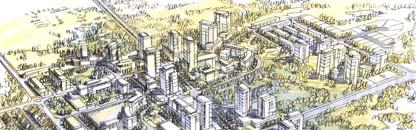
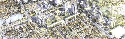
7 1.0 INTRODUCTION AND CONTEXT Carrville District Centre Urban Design Streetscape Master Plan Study THE CITY OF VAUGHAN

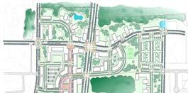
8 1.1 Background and Purpose The Carrville District Centre is a new and exciting urban centre with a compact physical form that is human in scale and designed to be pedestrian-friendly and transit supportive. The District Centre provides opportunities for community scale commercial facilities, coupled with more intense residential forms of development, and encourages mixed-use development. The Carrville District Centre is expected to contain 11,000 to 12,000 people and approximately 5,400 dwelling units. It is envisioned to have a main street and central urban square and supportive land uses surrounding the centre. After thorough analysis of the site, background information and relevant policies, EDA Collaborative Inc., in association with Giannone Petricone Associates Inc. Architects, developed the Carrville District Centre Urban Design Streetscape Master Plan Study. This study provides the guidelines and standards to ensure the future development of Carrville District Centre will be successful as a vibrant and inspiring place to live, work and play within the City of Vaughan. Carrville s important distinction is recognized by the creation of an urban centre complete with commercial and retail uses, live work uses, institutional uses, residential uses, mixed residential uses and urban spaces. The purpose of the Carrville District Centre Urban Design Streetscape Master Plan Study was to prepare Urban Design Guidelines and Detailed Streetscape Master Plans to guide future development in accordance with the Urban Design policies of the Carrville District Plan OPA 651. The final design concept for the community was developed with the City through extensive workshops and meeting with various stakeholders that commenced in the spring of This study establishes the layout and detailed design of the public and private streetscape spaces, pedestrian and bicycle connections, public amenities and open spaces, as well as criteria for building locations, forms, heights and massing in relation to the public realm. * A number of objectives for the District Centre were established by the City of Vaughan and have been addressed through the development of this study. Legend City of Vaughan * Study Area Figure 1: Carrville Context Plan 2 THE CITY OF VAUGHAN Carrville District Centre Urban Design Streetscape Master Plan Study

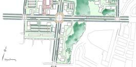
9 1.2 Policy Context The City of Vaughan Council approved The Carrville District Centre Official Plan Amendment (OPA) #651 on May 23, 2006 with a general intent that the plan becomes the focus for higher order land uses within the Carrville community. OPA 651 sets out policies to ensure that the Carrville District Centre will evolve into an urban core, with a compact physical form that is human in scale and is designed to be a pedestrian friendly and transit supportive area. Within this Centre there will be the opportunity for community scale commercial uses coupled with more intense residential forms, encouraging mixed-use development. District Avenue Marc Santi Boulevard The intent of the Urban Design Streetscape Master Plan Study is to expand upon the policies of OPA 651 by providing further urban design criteria and detail to assist in the preparation and evaluation of development plans within the District Centre. Dufferin Street The urban design objectives established by OPA 651 are to: (a) Promote high quality urban design within the area including streetscapes, open spaces, and public and private buildings, to create a comfortable, usable and memorable neighbourhood; (b) Create a strong community image by enhancing the character of the built environment including building design / massing, signage, planting and streetscapes; (c) Provide a transition between the concentrated uses within the District Centre and the surrounding lower densities; (d) Ensure neighbouring developments within the Centre and those adjoining it are compatible and complementary; (e) Create a pedestrian-friendly environment through the street layout, lot configuration and siting of all buildings; (f) Develop attractive streetscapes ensuring that development adjacent to the Main Street is a comfortable, human-scale for pedestrians; and, (g) Support transit by coordinating land use, transportation infrastructure and urban design in a complementary manner and encourage pedestrianoriented, transit-supportive development. Figure 2: Land Use Plan, Official Plan Amendment 651 Rutherford Road Legend Public Facilities Mixed Use 1 Mixed Use 2 High Density Residential Medium Density Residential Community Park Urban Neighbourhood Park Open Space Natural Features Stormwater Management Carrville District Centre Urban Design Streetscape Master Plan Study THE CITY OF VAUGHAN 3

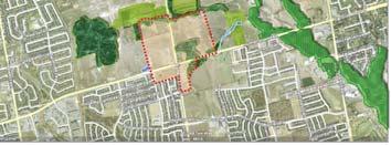
10 1.3 Site Analysis Site Context The Carrville District Centre is located in the east portion of the City of Vaughan, one of Canada s fastest growing urban centres. The site is comprised of approximately 57.0 hectares and is generally located at the intersection of Rutherford Road and Dufferin Street. The four quadrants surrounding the intersection are not equal in size and have extremely different environmental and existing development contexts, therefore the northwest quadrant of the site will be the primary focus of the District Centre. There are residential developments to the south of the Carrville District Centre, while development is in the initial stages on the east and west sides of the site. However, to the north of the Centre there is relatively little development occurring at this time. VELLORE MAPLE CARRVILLE The District Centre is in proximity to the Upper Don River Valley and many smaller tributaries, as well as several woodlots and vast open spaces; this will provide access for an extensive parks and open space network within the community. NASHVILLE / KLEINBURG EAST WOODBRIDGE THORNHILL WOODBRIDGE CONCORD Legend Carrville District Centre Study Area Figure 3: City of Vaughan Map 4 THE CITY OF VAUGHAN Carrville District Centre Urban Design Streetscape Master Plan Study

11 1.3.2 Topography The natural character of the Carrville District Centre is that of an extensive, gently sloping plain with surface drainage via overland flow running generally from west to north and southeast. Low points exist in the north and northeast corner of the site, as well as in the south, where there is an extensive valleyland and woodlot natural heritage system. A third low point is located at the southwest end just outside of the site boundary, where a Storm Water Management Pond is proposed to be located. The highest point of the site is located in the northwest corner, with a secondary high point near the intersection of Dufferin Street and Marc Santi Boulevard. The northwest quadrant is generally the highest and flattest area within the Carrville District Centre, while the northeast quadrant is quite steep in some areas and possesses noticeable topographic variations. District Avenue Dufferin Street Marc Santi Boulevard Rutherford Road Figure 4: Slope and Drainage Analysis Carrville District Centre Urban Design Streetscape Master Plan Study THE CITY OF VAUGHAN 5


12 1.3.3 Woodlots, Valleylands and Open Space Within the Carrville District Centre there is one relatively large woodlot located in the northeast quadrant and a smaller area in the southeast quadrant of the site which are protected as Environmental Policy Areas. The northwest and southwest quadrants are generally clear of any woodlots, valleylands or natural open space features. There is a second woodlot located along the northern edge of the site which extends past the District Centre boundary. There are significant natural open spaces located directly to the north of the northern valley / woodlot as well as to the east of the site, creating a large interconnected system of woodlots and open space immediately surrounding the District Centre. Farther to the east are valleylands and the Upper Don River. These lands serve to protect and enhance the natural ecosystem and to maintain ecological diversity within Vaughan. Most of the lands within the Centre are identified as a Settlement Area within the Oak Ridges Moraine Conservation Plan, meaning that it will be developed in a manner consistent with all appropriate legislation. Major Mackenzie Drive Dufferin Street Bathurst Street Rutherford Road Figure 5: Woodlots, Valleylands and Open Space Context 6 THE CITY OF VAUGHAN Carrville District Centre Urban Design Streetscape Master Plan Study
13 1.3.4 Circulation Two regional arterial roads create the major traffic node within the Carrville District Centre. Rutherford Road is the main east-west arterial road, and Dufferin Street is the main arterial road in a northsouth direction. These roads play an important role in the successful development of the Carrville District Centre. They provide access and allow opportunities for vehicular and pedestrian infiltration into the Carrville District Centre by means of minor collector roads perpendicular to these arterial roads. A smaller, community traffic node is located at the intersection of Dufferin Street and Marc Santi Boulevard. This intersection currently provides vehicular access through the northern portion of the site, connecting the two local roads running north-south along the site s east and west boundary. District Avenue Dufferin Street Marc Santi Boulevard The northwest quadrant is the most accessible area within the site. The regional and minor collector roads that border this quadrant provide numerous potential access points into the District Centre. District Avenue runs directly through this quadrant, connecting the Carrville District Centre with other areas in the City of Vaughan and the Region of York. LEGEND Regional Arterial Road Rutherford Road Existing Minor Collector Road Regional Traffic Node Community Traffic Node Site Photo Location (colour-coded with photographs on page 7) Figure 6: Existing Circulation Carrville District Centre Urban Design Streetscape Master Plan Study THE CITY OF VAUGHAN 7


")
")


14 1.3.5 Site Conditions Photographs Existing Roads Photos Marc Santi Boulevard (East of Dufferin Street) Existing Roads Photos Marc Santi Boulevard (West of Dufferin Street) Existing Roads Photos Dufferin Street Existing Roads Photos Rutherford Road Existing Roads Photos East Boundary of Site 8 THE CITY OF VAUGHAN Carrville District Centre Urban Design Streetscape Master Plan Study
THAT the attached Terms of Reference for the Thornhill Centre Street Study be approved.
 COMMITTEE OF THE WHOLE AUGUST 18, 2003 THORNHILL CENTRE STREET STUDY PLANNING FILE: 15.92 Recommendation The Commissioner of Planning recommends: THAT the attached Terms of Reference for the Thornhill
DRAFT Northeast Quadrant of Kipling Avenue and Highway 7 DRAFT AUGUST 29, Goals Land Use. The goals of this Plan are to:
 AUGUST 29, 2017 12.15 Northeast Quadrant of Kipling Avenue and Highway 7 12.15.1 Goals 12.15.2 Land Use The goals of this Plan are to: 12.15.2.1 General Provisions: a) Ensure the development of a compact
11.4 Highway 400 North Employment Lands Secondary Plan APPROVED BY THE ONTARIO MUNICIPAL BOARD ON NOVEMBER 21, 2011
 11.4 Highway 400 North Employment Lands Secondary Plan APPROVED BY THE ONTARIO MUNICIPAL BOARD ON NOVEMBER 21, 2011 11.4.1 General 11.4.1.1. as approved by the Ontario Municipal Board on November 21, 2011,
Report to: Development Services Committee Report Date: April 24, 2017
 SUBJECT: Cornell Rouge National Urban Park Gateway - Report on Design Charrette and Next Steps PREPARED BY: Lilli Duoba, MES, MCIP, RPP, Manager, Natural Heritage (ext. 7925) REVIEWED BY: Marg Wouters,
13 THORNHILL YONGE STREET STUDY IMPLEMENTATION CITY OF VAUGHAN OPA 669 AND TOWN OF MARKHAM OPA 154
 13 THORNHILL YONGE STREET STUDY IMPLEMENTATION CITY OF VAUGHAN OPA 669 AND TOWN OF MARKHAM OPA 154 The Planning and Economic Development Committee recommends the adoption of the recommendations contained
URBAN DESIGN BRIEF. 2136&2148 Trafalgar Road. Town of Oakville
 URBAN DESIGN BRIEF 2136&2148 Trafalgar Road Town of Oakville Prepared By: METROPOLITAN CONSULTING INC For 2500674 Ontario Inc November 2016 TABLE OF CONTENTS Page No. 1.0 Introduction/Description of Subject
11.4 Highway 400 North Employment Lands Secondary Plan
 11.4 Highway 400 North Employment Lands Secondary Plan APPROVED BY THE ONTARIO MUNICIPAL BOARD ON NOVEMBER 21, 2011 11.4.1 General 11.4.1.1. The following policies and Schedules A - I form Official Plan
Derry Green Corporate Business Park
 Town of Milton Derry Green Corporate Business Park Urban Design Guidelines BMI/Pace - June 2010 Draft 3 Prepared by: Brook McIlroy Planning + Urban Design / Pace Architects Suite 300-51 Camden Street Toronto,
ELMVALE ACRES SHOPPING CENTRE MASTER PLAN
 ELMVALE ACRES SHOPPING CENTRE MASTER PLAN Contents 1.0 INTRODUCTION... 2 2.0 LOCATION... 2 3.0 EXISTING CONTEXT... 2 4.0 VISION & GUIDING PRINCIPLES... 2 5.0 LAND USE AND BUILT FORM... 4 5.1 St. Laurent
The West Vaughan Employment Area Secondary Plan Policies
 Part 2: The West Vaughan Employment Area Secondary Plan Policies 2.1 General Policies It is the policy of Council: 2.1.1. That the West Vaughan Employment Area (the WVEA), identified on Schedule 1, will
Urban Design Brief. Watson Parkway North & Watson Road North Guelph, Ontario. Prepared by Coletara Development
 Urban Design Brief Watson Parkway North & Watson Road North Guelph, Ontario Prepared by Coletara Development December, 2013 Urban Design Brief, Coletara Development 1 Introduction This Urban Design Brief
YONGE STEELES CORRIDOR SECONDARY PLAN. Young + Wright / IBI Group Architects Dillon Consulting Ltd. GHK International (Canada) Ltd.
 Ltd.") PART A: PREAMBLE 1.0 PURPOSE The purpose of this Secondary Plan is to provide a development framework for intensification of the Yonge/ Steeles corridor including the north side of Steeles Avenue West
PART A: PREAMBLE 1.0 PURPOSE The purpose of this Secondary Plan is to provide a development framework for intensification of the Yonge/ Steeles corridor including the north side of Steeles Avenue West
9 CITY OF VAUGHAN OFFICIAL PLAN AMENDMENT NO BOCA EAST INVESTMENTS LIMITED
 9 CITY OF VAUGHAN OFFICIAL PLAN AMENDMENT NO. 631 - BOCA EAST INVESTMENTS LIMITED The Planning and Economic Development Committee recommends the adoption of the recommendations contained in the following
SPECIAL COMMITTEE OF THE WHOLE DECEMBER 9, 2002 BLOCK 12 BLOCK PLAN FILE BL CASTAN BATHURST TESTON CORPORATION ET AL PRELIMINARY REPORT
 SPECIAL COMMITTEE OF THE WHOLE DECEMBER 9, 2002 BLOCK 12 BLOCK PLAN FILE BL.12.99 CASTAN BATHURST TESTON CORPORATION ET AL PRELIMINARY REPORT Recommendation The Commissioner of Planning recommends: THAT
URBAN DESIGN BRIEF URBAN DESIGN BRIEF 721 FRANKLIN BLVD, CAMBRIDGE August 2018
 URBAN DESIGN BRIEF URBAN DESIGN BRIEF 721 FRANKLIN BLVD, CAMBRIDGE August 2018 DESIGN BRIEF CONTENTS PART A 1.0 INTRODUCTION 2.0 DESCRIPTION & ANALYSIS OF SITE CONTEXT 3.0 DESIGN CONSTRAINTS AND OPPORTUNITIES
[PLANNING RATIONALE] For Site Plan Control and Lifting of Holding Zone By-Law 101 Champagne Avenue. May 23, 2014
![[PLANNING RATIONALE] For Site Plan Control and Lifting of Holding Zone By-Law 101 Champagne Avenue. May 23, 2014](/thumbs/75/71599615.jpg "[PLANNING RATIONALE] For Site Plan Control and Lifting of Holding Zone By-Law 101 Champagne Avenue. May 23, 2014") [PLANNING RATIONALE] For Site Plan Control and Lifting of Holding Zone By-Law 101 Champagne Avenue May 23, 2014 Contents 1.0 Introduction... 2 2.0 Site Context... 2 2.1 Adjacent Uses... 2 Figure 1: Site
[PLANNING RATIONALE] For Site Plan Control and Lifting of Holding Zone By-Law 101 Champagne Avenue May 23, 2014 Contents 1.0 Introduction... 2 2.0 Site Context... 2 2.1 Adjacent Uses... 2 Figure 1: Site
Urban Design Brief December 23, 2015 Southside Construction Group Official Plan & Zoning By-Law Amendment
 Urban Design Brief Proposed Official Plan & Zoning By-Law Amendment 3244, 3263 and 3274 Wonderland Road South Southside Group December 23, 2015 TABLE OF CONTENTS Page No. INTRODUCTION... 1 SECTION 1 LAND
Mark-up of the effect of the proposed Bronte Village Growth Area OPA No.18 on the text of section 24, Bronte Village, of the Livable Oakville Plan
 Mark-up of the effect of the proposed Bronte Village Growth Area OPA No.18 on the text of section 24, Bronte Village, of the Livable Oakville Plan Notes: This document is provided for information purposes
Westwind Developments Ltd. PIONEER LANDS AREA STRUCTURE PLAN - PROPOSED AMENDMENT
 FEBRUARY 2013 TABLE OF CONTENTS 1.0 BACKGROUND... 1 1.1 Amendment... 1 2.0 LOCATION & CONTEXT... 2 2.1 Land Ownership... 2 3.0 POLICY CONTEXT... 3 3.1 Municipal Development Plan... 3 3.2 Capital Region
CITY OF VAUGHAN KIRBY GO TRANSIT HUB SUB-STUDY
 WELCOME! Thank you for attending, and welcome to the first of three Public Meetings for the Kirby GO Transit Hub Study. Your feedback is important to us, and will help inform the development of the draft
Complete Neighbourhood Guidelines Review Tool
 Complete Neighbourhood Guidelines Review Tool Prepared By: City of Regina Planning Department October 2014 Page 1 of 14 Community Development Review Checklist for Secondary Plans and Concept Plans The
SPECIAL COMMITTEE OF THE WHOLE DECEMBER 9, 2002 BLOCK 57/58 WEST BLOCK PLAN BLOCK PLAN FILE BL.57/58W.99 HUNTINGTON BUSINESS PARK LAND OWNERS
 SPECIAL COMMITTEE OF THE WHOLE DECEMBER 9, 2002 BLOCK 57/58 WEST BLOCK PLAN BLOCK PLAN FILE BL.57/58W.99 HUNTINGTON BUSINESS PARK LAND OWNERS Recommendation The Commissioner of Planning recommends: THAT
URBAN DESIGN BRIEF 305, 309, & 315 SOUTHDALE ROAD WEST LONDON ONTARIO
 URBAN DESIGN BRIEF 305, 309, & 315 SOUTHDALE ROAD WEST LONDON ONTARIO CARVEST PROPERTIES LTD. December 2013 Section 1 - Land Use Planning Context 1.1 Subject Lands The subject lands are located immediately
S o u t h C e n t r a l O u t l i n e P l a n. Leduc Business Park. North Leduc Industrial Area Structure Plan C it y of Led u c.
 Leduc Business Park North Leduc Industrial Area Structure Plan C it y of Led u c Prepared for Farm Air Properties Inc. January, 2007 Table of Contents Page Number 1.0 Purpose of Plan and Definition of
Public Open House. Yonge Street and Bernard Avenue (Bernard KDA) Planning Study Update Town of Richmond Hill. March 30, 2017
 Planning Study Update Town of Richmond Hill. March 30, 2017") Public Open House Yonge Street and Bernard Avenue (Bernard KDA) Planning Study Update Town of Richmond Hill March 30, 2017 Open House Review of Project Purpose and Process Policy Refresher Highlights of
Public Open House Yonge Street and Bernard Avenue (Bernard KDA) Planning Study Update Town of Richmond Hill March 30, 2017 Open House Review of Project Purpose and Process Policy Refresher Highlights of
Clairtrell Area Context Plan
 Clairtrell Area Context Plan March 2005 Urban Development Services City Planning Contents 1. Introduction... 4 2. Development Structure... 6 2.1 Streets... 7 2.1.1 Sheppard Avenue and Bayview Avenue...
URBAN DESIGN BRIEF. Terms of Reference. Purpose. When is an Urban Design Brief Required
 Purpose An Urban Design Brief (UDB) is intended to describe and illustrate proposed designs for new development projects and demonstrate how the City s Urban Design Guidelines and other City policies have
*** DRAFT 2 FOR PUBLIC REVIEW ***
 6.7 The area is generally bounded by the Red Hill Valley Parkway to the west, Lake Avenue to the east, the Queen Elizabeth Way (QEW) to the north, and by the properties just south of Queenston Road to
Brampton. Secondary Plan. Review. Bram West. A New Direction in Planning & Public Consultation
 Brampton Bram West Secondary Plan Review A New Direction in Planning & Public Consultation Introduction The Bram West Secondary Plan Review offers an important opportunity for the community to define a
URBAN DESIGN BRIEF 181 Burloak Drive, Oakville
 URBAN DESIGN BRIEF 181 Burloak Drive, Oakville February 2017 Our File: 1730B 230-7050 WESTON ROAD / WOODBRIDGE / ONTARIO / L4L 8G7 / T: 905 761 5588/ F: 905 761 5589/WWW.MHBCPLAN.COM TABLE OF CONTENTS
CONTENTS 2.0 A FRAMEWORK FOR SUSTAINABLE GROWTH 2.1 MANAGING SUSTAINABLE GROWTH THE VISION TO GOALS AND OBJECTIVES 2.3 MARKHAM STRUCTURE
 2 A Framework for Sustainable Growth 2.0 A FRAMEWORK FOR SUSTAINABLE GROWTH CONTENTS 2.1 MANAGING SUSTAINABLE GROWTH THE VISION TO 2031 2.2 GOALS AND OBJECTIVES 2.2.1 Protecting the Natural Environment
Bel-Air Lexus Automobile Service Station
 Bel-Air Lexus Automobile Service Station Design Brief 443-447 McArthur Avenue Ottawa April 30, 2015 14-1299-MCA Site Details Application: Site Plan Control Legal Description and Municipal Addresses: 443
CITY OF VAUGHAN EXTRACT FROM COUNCIL MEETING MINUTES OF NOVEMBER 15, 2016
 Item 11, Report No. 38, of the Committee of the Whole, which was adopted without amendment by the Council of the City of Vaughan on November 15, 2016. Regional Councillor Di Biase declared an interest
2.0 A FRAMEWORK FOR SUSTAINABLE GROWTH CONTENTS
 2-2 A Framework for Sustainable Growth 2.0 A FRAMEWORK FOR SUSTAINABLE GROWTH CONTENTS 2.1 MANAGING SUSTAINABLE GROWTH THE VISION TO 2031 2.2 GOALS AND OBJECTIVES 2.2.1 Protecting the Natural Environment
Portage Parkway Environmental Assessment Public Information Centre No. 1
 City of Vaughan Portage Parkway Environmental Assessment Public Information Centre No. 1 November 25, 2015 Welcome to the Public Information Centre This first Public Information Centre (PIC) introduces
5 TOWN OF MARKHAM OFFICIAL PLAN AMENDMENT NO. 144 MILLIKEN MAIN STREET SECONDARY PLAN
 5 TOWN OF MARKHAM OFFICIAL PLAN AMENDMENT NO. 144 MILLIKEN MAIN STREET SECONDARY PLAN The Planning and Economic Development Committee recommends the following: 1. The communication from Brendan O Callaghan,
Dufferin Street and Centre Street Area Specific Policies
 12.XX 12.XX.1 12.XX.1.1. 12.XX.2. 12.XX.2.1. 12.XX.2.2 Dufferin Street and Centre Street Area Specific Policies Goals The goal of this Plan is to provide the necessary land use and development policies
1.0 Purpose of a Secondary Plan for the Masonville Transit Village
 Report to Planning and Environment Committee To: Chair and Members Planning & Environment Committee From: John M. Fleming Managing Director, Planning and City Planner Subject: Masonville Transit Village
CONTENTS 6.1 URBAN DESIGN
 6-2 Urban Design and Sustainable Development 6.0 URBAN DESIGN AND SUSTAINABLE DEVELOPMENT CONTENTS 6.1 URBAN DESIGN 6.1.1 General Policies 6.1.2 The Public Realm 6.1.3 Streets and Blocks 6.1.4 Streetscapes
Urban Design Brief Proposed Residential Development 5219 Upper Middle Road City of Burlington
 Urban Design Brief Proposed Residential Development 5219 Upper Middle Road City of Burlington Prepared by Weston Consulting Prepared for BLOOMFIELD DEVELOPMENT INC. Date: March 2017 Table of Contents 1.
Welcome. Walk Around. Talk to Us. Write Down Your Comments
 Welcome This is an information meeting introducing the applications for proposed redevelopment of the Yorkdale Shopping Centre site at 3401 Dufferin Street and 1 Yorkdale Road over the next 20+ years,
URBAN DESIGN BRIEF NORTHVIEW FUNERAL HOME HIGHBURY AVE N, LONDON, ON
 URBAN DESIGN BRIEF NORTHVIEW FUNERAL HOME - 1490 HIGHBURY AVE N, LONDON, ON 1.1Purpose The intent of the following report is to identify an opportunity for redevelopment of two residential properties within
2. That Official Plan Amendments #671 and #672 BE ADOPTED.
 SPECIAL COMMITTEE OF THE WHOLE MAY 2, 2005 THORNHILL CENTRE STREET STUDY CITY OF VAUGHAN OFFICIAL PLAN AMENDMENTS DRAFT OPA #671 (THORNHILL TOWN CENTRE) DRAFT OPA #672 (CENTRE STREET SPINE) RELATED FILE:
North Oakville East Parks Facilities Distribution Plan. November, 2009
 North Oakville East November, 2009 POLICY CONTEXT 1) Purpose a) The purpose of this document is to be a guide for the location, configuration, design and development of the parks system for the North Oakville
John M. Fleming Managing Director, Planning and City Planner. Old East Village Dundas Street Corridor Secondary Plan Draft Terms of Reference
 Report to Planning and Environment Committee To: From: Subject: Chair and Members Planning & Environment Committee John M. Fleming Managing Director, Planning and City Planner Old East Village Dundas Street
Urban Design Brief. 583, 585 and 589 OXFORD STREET EAST. Salt Clinic Canada Inc.
 Urban Design Brief 583, 585 and 589 OXFORD STREET EAST Salt Clinic Canada Inc. February 3, 2013 TABLE OF CONTENTS Page No. INTRODUCTION... 1 SECTION 1 LAND USE PLANNING CONCEPT... 1 1.1 The Subject Property...
2 STATUTORY PUBLIC MEETING AND INFORMATION REPORT FOR PUBLIC MEETING ON AMENDMENT NO. 62 TO THE YORK REGION OFFICIAL PLAN
 2 STATUTORY PUBLIC MEETING AND INFORMATION REPORT FOR PUBLIC MEETING ON AMENDMENT NO. 62 TO THE YORK REGION OFFICIAL PLAN Pursuant to Section 17(15) of the Planning Act, as amended, the Regional Planning
Description of Preferred Alternative
 Chapter 2 Description of Preferred Alternative 2.1 Introduction This chapter of the programmatic Sammamish Town Center Sub-area Plan Final EIS provides a more detailed description of the Preferred Alternative
New-Cast Mixed-use Development Proposal King Street West, Newcastle, Ontario
 URBAN DESIGN BRIEF New-Cast Mixed-use Development Proposal King Street West, Newcastle, Ontario TABLE OF CONTENTS: 1.0 Executive Summary 2.0 Creating Vibrant and Sustainable Urban Places: Excerpts from
and Richmond Street West - Official Plan Amendment Application - Preliminary Report
 STAFF REPORT ACTION REQUIRED 822-838 and 860-862 Richmond Street West - Official Plan Amendment Application - Preliminary Report Date: August 14, 2017 To: From: Wards: Reference Number: Toronto and East
CITY OF VAUGHAN D R A F T YONGE STREET STUDY. June 2008 YOUNG + WRIGHT /IBI GROUP ARCHITECTS DILLON CONSULTING LTD.
 CITY OF VAUGHAN June 2008 YOUNG + WRIGHT /IBI GROUP ARCHITECTS GHK SUSTAINABILITY INTERNATIONAL + LIVABILITY (CANADA) LTD. = COMMUNITY VALUE DILLON CONSULTING LTD. Public Open House Tonight s Meeting WELCOME
LAND USE AMENDMENT CORNERSTONE (WARD 3) 60 STREET NE AND COUNTRY HILLS BOULEVARD NE MAP 26NE BYLAW 22D2017
 60 STREET NE AND COUNTRY HILLS BOULEVARD NE MAP 26NE BYLAW 22D2017") Page 1 of 14 EXECUTIVE SUMMARY This Land Use Amendment application covers an area of 43.76 hectares ± (108.14 acres ±) located in northeast Calgary, bound by Country Hills Boulevard NE to the south and
Page 1 of 14 EXECUTIVE SUMMARY This Land Use Amendment application covers an area of 43.76 hectares ± (108.14 acres ±) located in northeast Calgary, bound by Country Hills Boulevard NE to the south and
393, 395, 397, 399, 401 and 403 Spring Garden Avenue Official Plan and Zoning By-law Amendment Application Preliminary Report
 STAFF REPORT ACTION REQUIRED 393, 395, 397, 399, 401 and 403 Spring Garden Avenue Official Plan and Zoning By-law Amendment Application Preliminary Report Date: March 29, 2010 To: From: Wards: Reference
ARTICLE 6: Special and Planned Development Districts
 ARTICLE 6: Special and Planned Development Districts 6-10 Traditional Neighborhood Development (TND) District 6-10.10 Purpose and Intent The Traditional Neighborhood Development (TND) District provides
Bylaw No. B-03/2011 Adopted by Airdrie City Council February 21, 2012
 COOPER S CROSSING STAGE 4 Neighbourhood Structure Plan City of Airdrie WESTMARK HOLDINGS LTD. Bylaw No. B-03/2011 Adopted by Airdrie City Council February 21, 2012 CONSULTANTS: LAND USE PLANNING: Southwell
Attachment 1 TOWN OF NEW TECUMSETH. Manual for the Preparation of an Urban Design Report
 Attachment 1 TOWN OF NEW TECUMSETH Manual for the Preparation of an Urban Design Report July 2010 TABLE OF CONTENTS Background, Policy Framework and the Preparation of Urban Design Reports 1. Introduction
URBAN DESIGN BRIEF New Street Burlington, ON
 3225-3237 New Street Burlington, ON MARCH 2017 Prepared for: Royal Living Development Group Inc. Prepared by: adesso design inc. 218 Locke Street South, 2nd Floor Hamilton, ON L8P 4B4 t. 905.526.8876 3225-3237
OP Council Resolution June 16, Planning and Development Services
 OP-08-01 Council Resolution June 16, 2008 Planning and Development Services Kingsgate Landing Outline Plan Table of Contents 1.0 Introduction 1 1.1 Purpose of Plan 1 1.2 Plan Area Location 1 1.3 Ownership
EXISTING COMPREHENSIVE PLAN
 EXISTING COMPREHENSIVE PLAN Town Center Land Use Element: V. LAND USE POLICIES Town Center Mercer Island's business district vision as described in "Your Mercer Island Citizen-Designed Downtown" was an
URBAN DESIGN STUDY and GUIDELINES
 ALTON CENTRAL EAST COMMUNITY CITY OF BURLINGTON URBAN DESIGN STUDY and GUIDELINES Prepared by NAK DESIGN GROUP March 2004 ALTON CENTRAL EAST CITY OF BURLINGTON TABLE OF CONTENTS PART I - Alton Central
1.0 PLANNING MARKHAM S FUTURE CONTENTS
 1-1 Planning Markham s Future 1.0 PLANNING MARKHAM S FUTURE CONTENTS 1.1 THE PURPOSE OF THE OFFICIAL PLAN 1.2 THE MARKHAM CONTEXT 1.3 THE REGULATORY CONTEXT 1.3.1 Province of Ontario 1.3.2 York Region
Urban Design Manual PLANNING AROUND RAPID TRANSIT STATIONS (PARTS) Introduction. Station Study Areas
 Introduction. Station Study Areas") 111111 PLANNING AROUND RAPID TRANSIT STATIONS (PARTS) Introduction The ION rapid transit system will link Waterloo, Kitchener and Cambridge through a central transit corridor (CTC). There are a number
111111 PLANNING AROUND RAPID TRANSIT STATIONS (PARTS) Introduction The ION rapid transit system will link Waterloo, Kitchener and Cambridge through a central transit corridor (CTC). There are a number
11.5 Kipling Avenue Corridor Secondary Plan
 11.5 Kipling Avenue Corridor Secondary Plan ADOPTED BY VAUGHAN CITY COUNCIL NOT YET APPROVED BY THE ONTARIO MUNICIPAL BOARD 11.5.1 Development Principles and Objectives The following principles support
DUNDAS TRAFALGAR DUNDAS TRAFALGAR. (North Oakville) (NORTH OAKVILLE) Urban Design Brief. Urban Design Brief. Prepared by: NAK Design Strategies
 (NORTH OAKVILLE) Urban Design Brief. Urban Design Brief. Prepared by: NAK Design Strategies") DUNDAS TRAFALGAR (NORTH OAKVILLE) Urban Design Brief DUNDAS TRAFALGAR (North Oakville) Urban Design Brief Prepared by: NAK Design Strategies Prepared for: Dundas Trafalgar Inc. December 2014 TABLE OF
DUNDAS TRAFALGAR (NORTH OAKVILLE) Urban Design Brief DUNDAS TRAFALGAR (North Oakville) Urban Design Brief Prepared by: NAK Design Strategies Prepared for: Dundas Trafalgar Inc. December 2014 TABLE OF
PORT WHITBY COMMUNITY
 PORT WHITBY COMMUNITY SECONDARY PLAN UPDATE COMMUNITY IMPROVEMENT PLAN URBAN DESIGN GUIDELINES September 2015 DRAFT PROPOSED AMENDMENT NUMBER # to the Whitby Official Plan PURPOSE: The intent of this Amendment
Central and East Neighbourhoods - Hermitage Outline Plan
 Central and East Neighbourhoods - Hermitage Outline Plan Office Consolidation September 2013 Prepared by: Planning and Policy Services Branch Planning and Development Department City of Edmonton The Central
SCHEDULE 'A' TO BY-LAW as Amended by AMENDMENT NO. 90 TO THE WHITBY OFFICIAL PLAN
 SCHEDULE 'A' TO BY-LAW 6413-10 as Amended by 6553-11 AMENDMENT NO. 90 TO THE WHITBY OFFICIAL PLAN SECTION A: GROWTH PLAN CONFORMITY PURPOSE: LOCATION: BASIS: The purpose of this Amendment is to: conform
Staff Report and Recommendation
 Community Planning and Development Planning Services 201 W. Colfax Ave., Dept. 205 Denver, CO 80202 p: 720.865.2915 f: 720.865.3052 www.denvergov.org/cpd TO: City Council Neighborhoods and Planning Committee
Workshop #1 Outcomes. The Planning Partnership
 Workshop #1 Outcomes The Planning Partnership 1 Background Review Planning Provincial Policy Statement Greenbelt Plan Places to Grow: Growth Plan York Region Official Plan York Region Draft Official Plan
DUFFERIN CENTRE STUDY REPORT March 7, 2017 DRAFT. with Poulos & Chung Limited
 DUFFERIN CENTRE STUDY REPORT March 7, 2017 DRAFT with Poulos & Chung Limited DUFFERIN CENTRE STUDY REPORT March 7, 2017 with Poulos & Chung Limited \\ toc CONTENTS intro Introduction 1 1 2 3 Background
McCowan Precinct Plan Study Background & Deliverables
 1 DRAFT & WITHOUT PREJUDICE McCowan Precinct Plan Study Background & Deliverables In September, 2011, City Planning (Scarborough District) began a study of an area within the Scarborough Centre, identified
Planning, Property and Development Department Report. To the Riel Community Committee
 Planning, Property and Development Department Report To the Riel Community Committee Date: October 30, 2006 File: SP 5/2006 Subject: Waverley West Northeast Neighbourhood Area Structure Plan Location:
BROOKHILL NEIGHBORHOOD MODEL ZONING MAP AMENDMENT PREFACE TO APPLICATION
 BROOKHILL NEIGHBORHOOD MODEL ZONING MAP AMENDMENT PREFACE TO APPLICATION June 15, 2015 Revised: August 1, 2016 I. VISION Brookhill is a proposed community based upon the principles of Albemarle County
Former Rockcliffe Airbase Community Design Plan Guiding Design Vision and Principles December 4, 2013
 APPENDIX 5 - Guiding Design Vision and Principles Former Rockcliffe Airbase Community Design Plan Guiding Design Vision and Principles December 4, 2013 Vision Statement The redevelopment of the former
Official Plan Review: Draft Built Form Policies
 PG.30.1 REPORT FOR ACTION Official Plan Review: Draft Built Form Policies Date: May 15, 2018 To: Planning and Growth Management Committee From: Chief Planner and Executive Director, City Planning Division
NOBLETON COMMUNITY PLAN
 NOBLETON COMMUNITY PLAN TOWNSHIP OF KING Office Consolidation February, 2005 AMENDMENT NO. 57 to the OFFICIAL PLAN for the TOWNSHIP OF KING PLANNING AREA TABLE OF CONTENTS PART I THE PREAMBLE 1. Amendment
2.0 A FRAMEWORK FOR SUSTAINABLE GROWTH CONTENTS
 2-2 A Framework for Sustainable Growth 2.0 A FRAMEWORK FOR SUSTAINABLE GROWTH CONTENTS 2.1 MANAGING SUSTAINABLE GROWTH THE VISION TO 2031 2.2 GOALS AND OBJECTIVES 2.2.1 Protecting the Natural Environment
Official Plan Review
 Official Plan Review Summary Report - The Built Environment August 2014 Part 1: Introduction Planning for a healthy, prosperous and sustainable community is an important goal for our municipality. From
Lehigh Acres Land Development Regulations Community Planning Project
 Lehigh Acres Land Development Regulations Planning Effort Summary In July, 2010 Commissioner Frank Mann invited the Lehigh Acres community to start discussing how to achieve their recently adopted community
hermitage town center
 hermitage town center A Community Vision prepared by Strada for The City of Hermitage and The Mercer County Regional Planning Commission January 2007 table of contents introduction 3 design principles
Community Design Guidelines. Port Wallace DRAFT
 Community Design Guidelines Port Wallace DRAFT Energy 1 2 3 Nature Movement Connections Built Form DRAFT Layout Energy 1 Nature Community Design Guidelines GREAT COMMUNITIES PROTECT, CELEBRATE, AND CONSERVE
Regency Developments. Urban Design Brief. Holyrood DC2 Rezoning
 Regency Developments Urban Design Brief Holyrood DC2 Rezoning Stantec Consulting Ltd. 7-31-2017 1. Overview Regency Developments intends to rezone the lands located at 8510 and 8511 93 Avenue, within the
12 AMENDMENT NO. 149, TOWN OF MARKHAM HIGHWAY 404 NORTH SECONDARY PLAN
 12 AMENDMENT NO. 149, TOWN OF MARKHAM HIGHWAY 404 NORTH SECONDARY PLAN The Planning and Economic Development Committee recommends the adoption of the recommendation contained in the following report August
and services The protection and conservation of environmentally significant and sensitive natural heritage features and functions.
 6. Land Use 6.0 Preamble A healthy and livable city is one in which people can enjoy a vibrant economy and a sustainable healthy environment in safe, caring and diverse neighbourhoods. In order to ensure
Bressa Developments Limited. Planning Justification Report. Revised Draft Plan of Subdivision and Zoning By-Law Amendment
 Bressa Developments Limited Revised Draft Plan of Subdivision and Zoning By-Law Amendment Planning Justification Report Part of Lots 7 & 8 Concession 1, North of Dundas Street Town of Oakville September,
5.0 Community Design Plan
 5.0 Community Design Plan The Community Design Plan for the Mer Bleue area is a composite of three plans: Land Use Plan Transportation Plan Municipal Servicing Plan Read together, these Plans and associated
Policies and Code Intent Sections Related to Town Center
 Policies and Code Intent Sections Related to Town Center The Town Center Vision is scattered throughout the Comprehensive Plan, development code and the 1994 Town Center Plan. What follows are sections
LAND USE AMENDMENT DOWNTOWN COMMERCIAL CORE (WARD 7) MACLEOD TRAIL SE AND 5 AVENUE SE BYLAW 254D2017
 MACLEOD TRAIL SE AND 5 AVENUE SE BYLAW 254D2017") Page 1 of 10 EXECUTIVE SUMMARY This Land Use Amendment application seeks to redesignate a full downtown block (currently the YWCA site) from a Direct Control based on the CM-2 District (Land Use Bylaw
Page 1 of 10 EXECUTIVE SUMMARY This Land Use Amendment application seeks to redesignate a full downtown block (currently the YWCA site) from a Direct Control based on the CM-2 District (Land Use Bylaw
ZONING BY-LAW AMENDMENT FILE Z NORTHWEST JANE RUTHERFORD REALTY LIMITED REPORT #P
 COMMITTEE OF THE WHOLE JUNE 16, 2003 ZONING BY-LAW AMENDMENT FILE Z.02.080 NORTHWEST JANE RUTHERFORD REALTY LIMITED REPORT #P.2003.32 Recommendation The Commissioner of Planning recommends: THAT the OMB
Sharon Village Urban Design Guidelines
 Sharon Village Urban Design Guidelines February, 2010 SHARON Malone Given Parsons Ltd. NAK Design Group MMM Group [This page intentionally left blank] Table of Contents 1.0 Introduction 1-1 1.1 The Role
13. VANDORF-PRESTON LAKE SECONDARY PLAN 13.1 INTRODUCTION
 13. VANDORF-PRESTON LAKE SECONDARY PLAN 13.1.1 Purpose 13.1 INTRODUCTION The Vandorf-Preston Lake Secondary Plan establishes the principles, objectives and general policies, as well as specific strategies
~!VAUGHAN NOV Z November 21, Mr. Denis Kelly, Regional Clerk The Regional Municipality of York Yonge Street Newmarket, ON L3Y 6Z1
 ~!VAUGHAN NOV Z 5 2016 November 21, 2016 Mr. Denis Kelly, Regional Clerk The Regional Municipality of York 17250 Yonge Street Newmarket, ON L3Y 6Z1 Dear Mr. Kelly: RE: NEW KIRBY GO STATION IN BLOCK 27
Draft Urban Hamilton Official Plan. Amendment No. XX
 1 of 75 The following text, together with: Draft Appendix A Appendix B Volume 1, Schedule E-1 Urban Land Use Designations Appendix C Volume 1, Appendix A Parks Classification Map Appendix D Volume 1, Appendix
Toronto Complete Streets Guidelines
 Toronto Complete Streets Guidelines 108 110 7.1 Green Infrastructure Design Principles 112 7.2 Context-Sensitive Green Streets 114 7.3 Key Green Street Elements Green infrastructure refers to natural and
CONTENTS 8.0 LAND USE 8.1 GENERAL LAND USE 8.2 RESIDENTIAL 8.3 MIXED USE 8.4 COMMERCIAL 8.5 EMPLOYMENT LANDS
 8-2 Land Use 8.0 LAND USE CONTENTS 8.1 GENERAL LAND USE 8.1.1 Uses provided for in all Land Use Designations 8.1.2 Uses prohibited in Hazardous Lands, Hazardous Sites and Special Policy Areas 8.1.3 Uses
Bank Street Secondary Plan
 1.1 Introduction The is a guide to the long term design and development of the portion of Bank Street between Riverside Drive and Ledbury Park, and provides direction on land use, built form, design, parking,
OFFICE CONSOLIDATION SECONDARY PLAN AREA 48. CHAPTER 48(b) COUNTRYSIDE VILLAGES SECONDARY PLAN
 COUNTRYSIDE VILLAGES SECONDARY PLAN") OFFICE CONSOLIDATION SECONDARY PLAN AREA 48 CHAPTER 48(b) COUNTRYSIDE VILLAGES SECONDARY PLAN October 2016 TABLE OF CONTENTS (Part II, Chapter 48(b)) Purpose. 1.0 Location 2.0 Effect of this Chapter and
OFFICE CONSOLIDATION SECONDARY PLAN AREA 48 CHAPTER 48(b) COUNTRYSIDE VILLAGES SECONDARY PLAN October 2016 TABLE OF CONTENTS (Part II, Chapter 48(b)) Purpose. 1.0 Location 2.0 Effect of this Chapter and
STAFF REPORT. December 20, North York Community Council. Director, Community Planning, North York District
 STAFF REPORT December 20, 2005 To: From: Subject: North York Community Council Director, Community Planning, North York District Preliminary Report Application to Amend the Official Plan and Zoning By-law
KING CITY COMMUNITY PLAN
 KING CITY COMMUNITY PLAN TOWNSHIP OF KING JANUARY 27, 2000 AMENDMENT NO. 54 to the OFFICIAL PLAN for the TOWNSHIP OF KING PLANNING AREA THE COMMUNITY PLAN TABLE OF CONTENTS PAGE PART 1 INTRODUCTION 1.1
CITY OF VAUGHAN EXTRACT FROM COUNCIL MEETING MINUTES OF MAY 27, 2014
 CITY OF VAUGHAN EXTRACT FROM COUNCIL MEETING MINUTES OF MAY 27, 2014 Item 6, Report No. 21, of the Committee of the Whole, which was adopted without amendment by the Council of the City of Vaughan on May