UNIFIED DEVELOPMENT CODE
|
|
|
- Dorthy Chapman
- 6 years ago
- Views:
Transcription

1
2 Zoning UNIFIED DEVELOPMENT CODE Regulates how land is used Sets dimensional requirements for structures Addresses all aspects of site development: accessory structures, temporary uses, parking, landscape, signs Subdivision Rules for dividing land into buildable lots Standards for public improvements Assist in preservation - conservation design
3 Organization Introduction Districts On-Site Development Off-Site Development General Administration Zoning Approvals Subdivision Approvals Implementation COMPARTMENTALIZATION Article 1. Title, Purpose, & Transition Article 2. Rules of Measurement & General Definitions Article 3. Zoning Districts & Zoning Map Article 4. Zoning District Regulations Article 5. Uses Article 6. Use Standards Article 7. On-Site Development Standards Article 8. Off-Street Parking & Loading Article 9. Signs Article 10. Landscape & Tree Preservation Article 11. Stormwater Management Article 12. Right-of-Way & Access Standards Article 13. Subdivision Standards Article 14. Code Administrators Article 15. Application Procedures Article 16. Zoning Approvals Article 17. Subdivision Approvals Article 18. Nonconformities Article 19. Enforcement Article 20. Annexation Rules
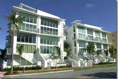
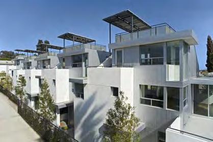
4 Residential Districts Revised lot dimension standards for conformity Design standards by dwelling type Manufactured home park design & siting standards Single-family residential conversions permissions R-HU Highland Urban Conservation Standards maintained Site plan review required Demolition permit requires 120 day delay R-UC Urban Core - NEW Urban residential redevelopment 3,000sf/du lot size
5
6
7
8
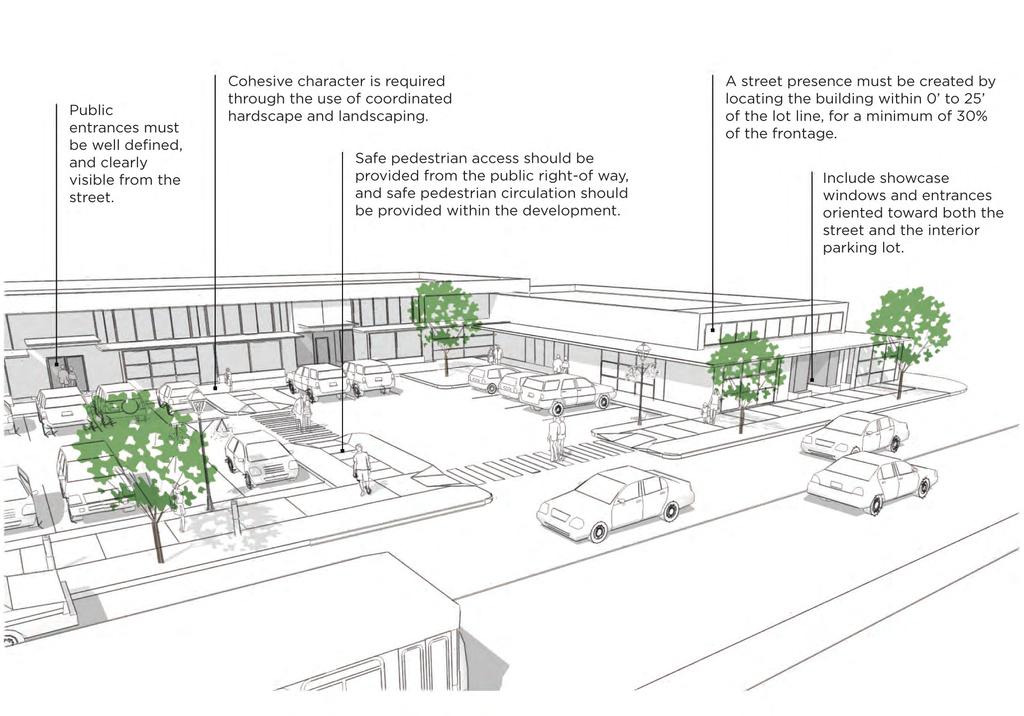
9 Commercial Districts C-1 Neighborhood Commercial Zoning District C-2 Corridor Commercial Zoning District C-3 General Commercial Zoning District C-4 Heavy Commercial Zoning District C-UV Urban Village Commercial Zoning District C-UV Urban Village - NEW Large-scale mixed-use Minimum 10 acre site Standards for commercial and residential development Design and siting standards

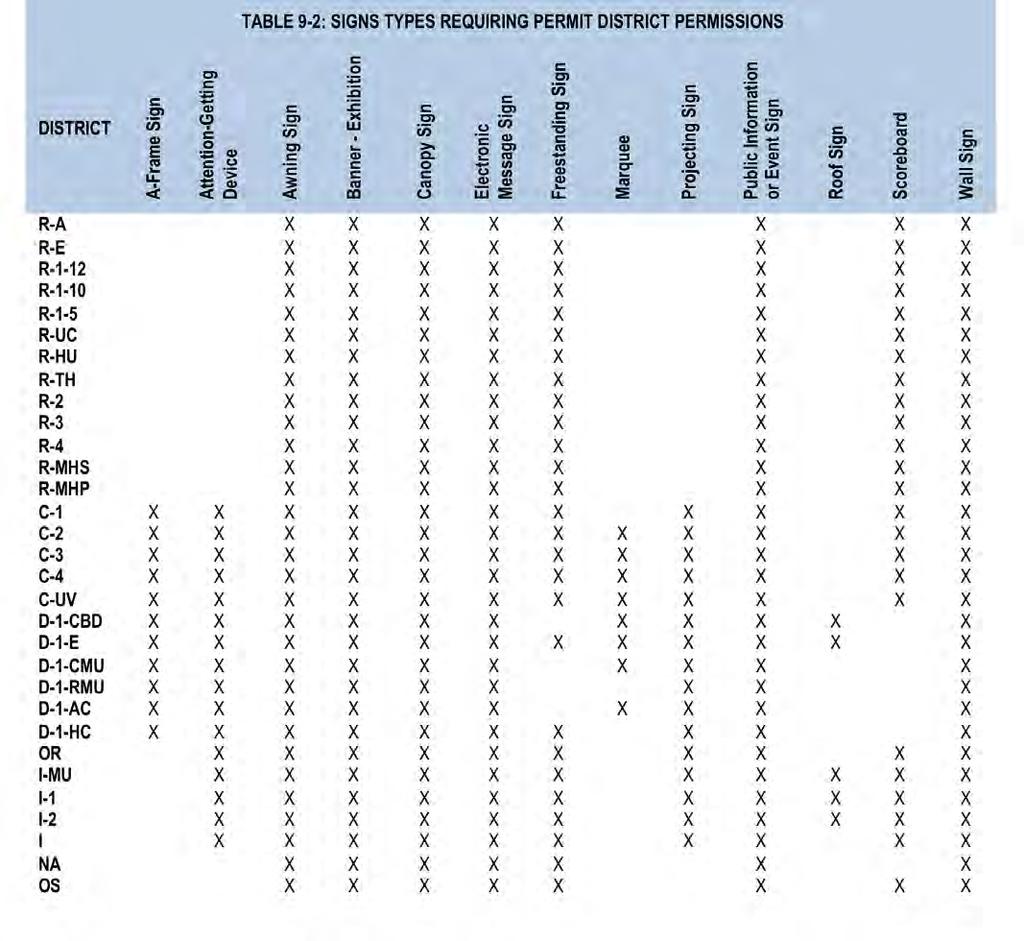
10 Design Standards Tables X indicates it is applicable in the district

11
12
13
14
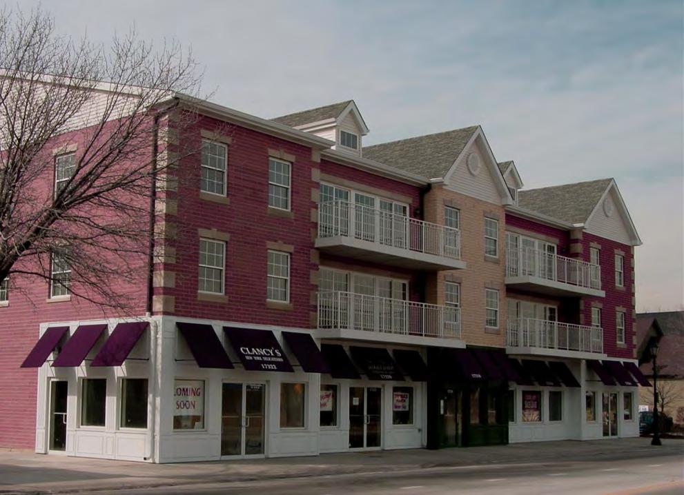
15 Downtown Districts D-1 Downtown Zoning District D-1-CBD Downtown Core Sub-District D-1-E Downtown Entertainment Sub-District D-1-CMU Downtown Commercial Mixed-Use Sub-District D-1-RMU Downtown Residential Mixed-Use Sub-District D-1-AC Downtown Arts and Culture Sub-District D-1-HC Downtown Heavy Commercial Sub-District Downtown Districts Height determined by location on map Design standards by sub-district
16
17
18 Industrial Districts OR Office Research Zoning District I-MU Industrial Mixed-Use Zoning District I-1 Light Industrial Zoning District I-2 Heavy Industrial Zoning District OR Office Research Large office developments Mix of office and light industrial uses to encourage tech, research I-MU Industrial Mixed-Use - NEW Address areas of transition & facilitate reuse Mix of light and artisan industrial uses with commercial and arts
19
20

21

22
23 Open Space Districts NA Natural Areas OS Open Space Waterfront Districts RBO Riparian Buffer Overlay CLO Cross Lake Overlay RRO Red River Overlay I Institutional Campus University or hospital campuses Allows for Institutional Master Plan (IMP) to exceed base standards - review by MPC; Approved by City or Parish RP Residential Professional Overlay Allow certain single-family dwellings to be used for office-type uses Maintain residential character

24 Modern generic use approach Principal & Temporary Uses Article 5: Use Matrix Use Definitions Article 6: Use Standards Modern & unique uses Neighborhood commercial establishment Solar and wind energy Reception facilities Retail sales of alcohol Live entertainment uses HOURS OF OPERATION ELIMINATED FROM CODE

25 Use Regulations! Each district assigned a set of permitted & special uses E Extended Use District eliminated! Special uses require either City Council or Parish Commission approval! If use is not listed in district, it s not allowed! Use standards for select uses that must be complied with! Full range of temporary uses

26 Comprehensive accessory structures Allow more than one structure Remove 450sf limit for structures Regulate by accessory structure type General structures Detached garages, sheds, fences General uses Storage, home occupations Sustainability Solar, wind, lighting, farmstands Animal- Related Livestock, chickens, bees Address permitted encroachments Allowed encroachments into required yards
27 Exterior Lighting Minimize glare and light pollution Special standards for outdoor recreation fields Home-Based Business Updated to be more flexible Client visit hours limited and by appointment only Additional limitations on barber shop/beauty shop Livestock R-A, R-E, R-1-12, R-1-10 Districts only Register horses with Animal Control deem existing conforming Minimum lot size of 1 acre + additional area required by animal type & square footage of open space
28 Update off-street parking Parking lot & structure design Location permissions, including off-site Parking ratios updated & linked to use structure Parking maximums: non-residential over 15,000sf limited to 115% Curb cut permissions & driveway sizes Motorcycle spaces may be substituted for auto spaces Required bicycle parking Long-term and short-term requirements Design and siting standards

29


30 Parking Exemptions D-1 District Any lot under 5,000sf in R-UC First 2,500sf of non-residential in C-1 and C-2 Neighborhood Commercial Establishment use Existing structures as of Code effective date that do not provide parking Parking Flexibilities Shared parking Cross-access servitudes Car/bike share facilities Electric charging stations


31 Comprehensive sign controls Standards for construction & location Limit on items of information Illumination regulations Prohibited sign types Cabinet box wall signs Permanent & temporary signs Sign permit exempt signs Stricter billboard regulations Permissions for electronic signs Provision for classic signs PROHIBITED
32

33

34 BILLBOARDS Permitted: 1. Within 660 of any federal highway on non-residential lots 2. I-2 District Prohibited within 1,000 of Clyde E. Fant Memorial Parkway, or within 500 of I-220 or Inner Loop Expressway Three nonconforming billboards must be removed to install one new


35 Landscape requirements Tree preservation Shade tree plantings by district Interior & perimeter parking lot landscape Buffer yard Downtown is not exempt from landscape Stormwater Management 10,000sf of impervious surface - SF & 2F exempt Landscape plan or submittal of LADEQ plan Use of best practices required

36 Parking Lot Perimeter

37 Parking Lot Interior

38 Buffer Yard
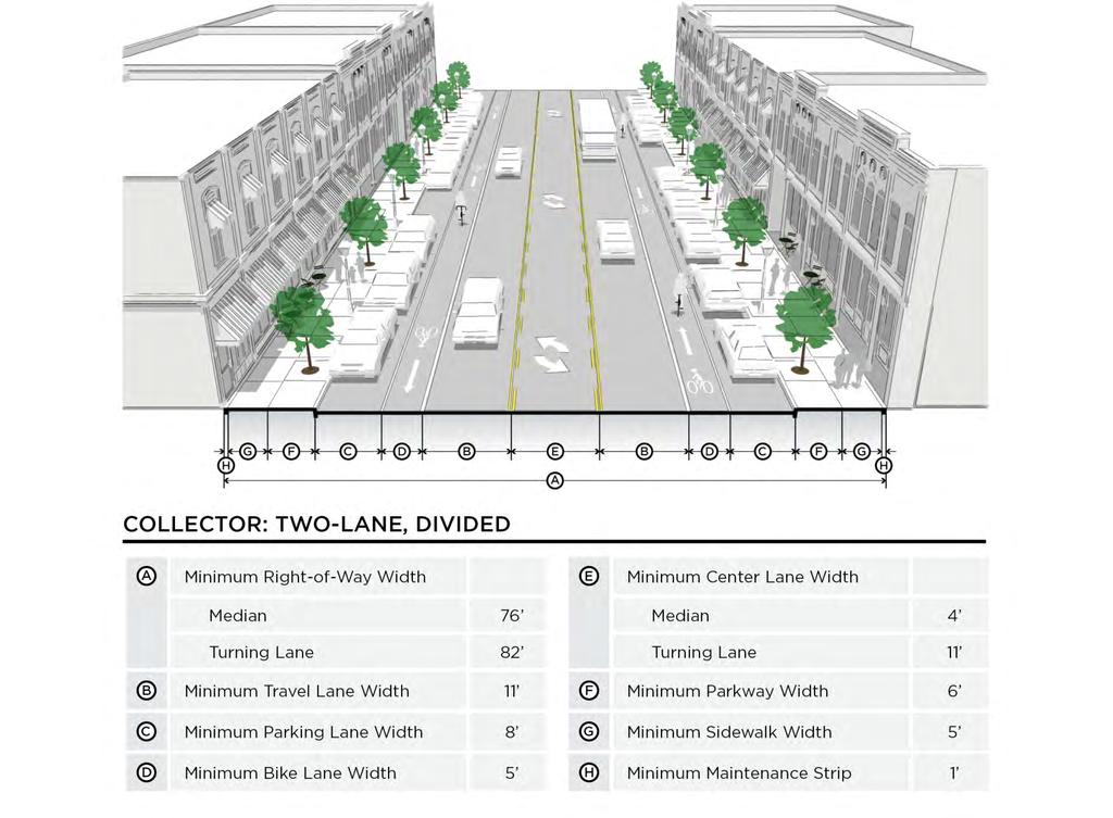
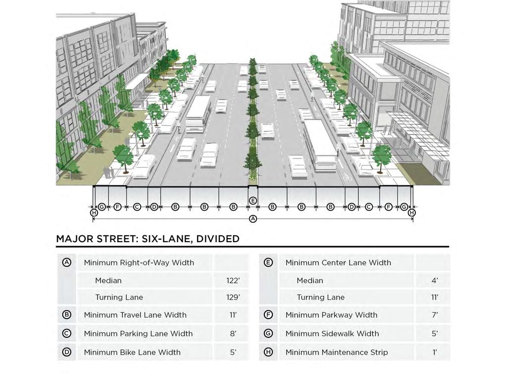
39 ROW & Access Regulations Complete Streets design Block standards Sidewalk standards Bike lane standards Right-of-way dimensions
40
41
42

43
: R-A and R-E District Medium Density (CD-M): R-1-12 and R-1-10 District High Density (CD-H): R-1-5 District; requires connection to public sewer")
44 Conservation Design Standards Minimum of 40 acres; zoned residential 40% of area maintained in natural state or common open space Residential clusters Perimeter buffer yard of 75 feet Conservation Design Low Density (CD-L): R-A and R-E District Medium Density (CD-M): R-1-12 and R-1-10 District High Density (CD-H): R-1-5 District; requires connection to public sewer

45 RR = Review and Recommendation; makes recommendation to decision-making body PH = Public Hearing; holds the public hearing FA = Final Approval; makes the decision AP = Appeal; hears the appeal of a decision
46 Text Amendments Text amendment approved by both City and Parish If opposing decision, forwarded to MPC Master Plan Sub-Committee for review & drafting of amendments, then resubmitted Special Use Permit New application approved by City or Parish based on location Site plan review by MPC required Variance Zoning Board of Appeals approves Certain variances are administrative exceptions approved by Executive Director ZBA will only approve variances & zoning appeals
47 Site Plan Review Metropolitan Planning Commission 1. Special uses 2. Certain uses identified in use standards as requiring site plan review Executive Director Development Review Committee & MPC Staff provide comments 1. New townhouse, multi-family, and non-residential 2. Additions to existing townhouse, multi-family, and non-residential that increase total floor area by 30% or more 3. New parking lots of 20 or more spaces. 4. Drive-through facilities 5. Non-residential development in RP Overlay 6. Planned unit developments
48 Specifically address variety of nonconforming situations Nonconforming use Nonconforming structure Nonconforming site element Nonconforming lot Nonconforming sign
49 Questions or Comments
RESIDENTIAL DISTRICTS
 RESIDENTIAL DISTRICTS The residential district standards have been revised to reflect on-the-ground conditions, while continuing to respect the use patterns established within the neighborhoods. This will
Zoning Technical Review Presented by Camiros. November 10, 2015
 Zoning Technical Review Presented by Camiros November 10, 2015 TECHNICAL REVIEW OVERVIEW Purpose of this Report Outline issues with current Ordinance Present preliminary approaches for revisions Set drafting
Agenda. Presentation (30 minutes) Overview of RIV District Next Steps / Calendar Display Stations. Display Station Discussion
 Overview of RIV District Next Steps / Calendar Display Stations. Display Station Discussion") Agenda Presentation (30 minutes) Overview of RIV District Next Steps / Calendar Display Stations Display Station Discussion RIV District Overview What is in the District? Purpose & Subdistricts Required
Agenda Presentation (30 minutes) Overview of RIV District Next Steps / Calendar Display Stations Display Station Discussion RIV District Overview What is in the District? Purpose & Subdistricts Required
TRANSFORM BALTIMORE NEW ZONING CODE. Laurie Feinberg, Asst. Director
 Laurie Feinberg, Asst. Director 4/5/2017 1 History and Summary of Process Principles of the code New Designations Use Tables Bulk Regulations Design and Landscape Guidelines Liquor Outlet Reduction Urban
SECTION UNIFIED DEVELOPMENT ORDINANCE SECTION Part 1 Ordinance. ARTICLE 1 Zoning Districts
 SECTION 1-100 UNIFIED DEVELOPMENT ORDINANCE SECTION 1-300 Part 1 Ordinance SECTION 1-100. Introduction. ARTICLE 1 Zoning Districts Crystal Lake strives to maintain a balance of various land uses for a
TRANSFORM BALTIMORE NEW ZONING CODE
 Laurie Feinberg, Asst. Director 4/26/2017 1 History and Summary of Process Principles of the code New Designations Use Tables Bulk Regulations Design and Landscape Guidelines Liquor Outlet Reduction Urban
17.11 Establishment of Land Use Districts
 17.11 Establishment of Land Use Districts 17.11.010 Purpose. To promote the health, safety, and general welfare of City residents and those who come to South Salt Lake to work, exchange commerce and recreate.
Today s Agenda. Introduction to Camiros. Introduction to Zoning. Overview of Project Process Current understandings What we ve heard so far
 Today s Agenda Introduction to Camiros Introduction to Zoning Overview of Project Process Current understandings What we ve heard so far Public Comment Camiros Key Personnel Arista Strungys, AICP, PP Principal
Presentation of the Staff Draft. July 17, 2014 SSRVP Team, Area 3
 Presentation of the Staff Draft July 17, 2014 SSRVP Team, Area 3 Presentation Overview Introduction Plan Framework Plan Recommendations Implementation Next Steps and Request for Public Hearing on September
MIAMI 21 CODE MAY This document is amended as of May 26, 2011.
 CODE MAY 2011 This document is amended as of May 26, 2011. THIS PAGE LEFT INTENTIONALLY BLANK. TABLE OF CONTENTS PREAMBLE ARTICLE 1. DEFINITIONS OF TERMS AND USES 1.1 Definitions of Building Function:
A. Reducing noise pollution, air pollution, and visual pollution;
 A well designed landscape, when made an integral part of a development plan, provides aesthetic appeal and makes an important contribution to the health, safety, and general welfare of the community by:
MIXED-USE VILLAGE OVERLAY FLOATING DISTRICT
 MIXED-USE VILLAGE OVERLAY FLOATING DISTRICT Zoning regulations developed by committee to the Planning Board for the Town of DeWitt, NY Issue date: 13 July 2017 revised 3/12/2018, revised 4/26/2018, 5/9/2018
LIST OF TABLES, FIGURES AND APPENDICES
 LIST OF TABLES, FIGURES AND APPENDICES Chapter Page 2 INTERPRETATION FIGURE 2.1 SAMPLE AWNING...2.8 FIGURE 2.2 SAMPLE LOW-RISE APARTMENT DESIGN...2.9 FIGURE 2.3 SAMPLE DUPLEX DESIGN...2.10 FIGURE 2.4 SAMPLE
CITY PLANNING COMMISSION AGENDA. ITEM NO(s): C.1 C.3 STAFF: STEVE TUCK
: C.1 C.3 STAFF: STEVE TUCK") Page 34 CITY PLANNING COMMISSION AGENDA ITEM NO(s): C.1 C.3 STAFF: STEVE TUCK FILE NOS: CPC ZC 12-00035 QUASI-JUDICIAL CPC NV 12-00036 QUASI-JUDICIAL AR DP 12-00039 QUASI-JUDICIAL PROJECT: APPLICANT: OWNER:
Page 34 CITY PLANNING COMMISSION AGENDA ITEM NO(s): C.1 C.3 STAFF: STEVE TUCK FILE NOS: CPC ZC 12-00035 QUASI-JUDICIAL CPC NV 12-00036 QUASI-JUDICIAL AR DP 12-00039 QUASI-JUDICIAL PROJECT: APPLICANT: OWNER:
City of Albuquerque. Integrated Development Ordinance (IDO) Training Development Standards. March 30 & April 4,
 Training Development Standards. March 30 & April 4,") City of Albuquerque Integrated Development Ordinance (IDO) Training Development Standards March 30 & April 4, 2018 www.abc-zone.com IDO Trainings FAQs by Topic March 21 & 23 March 30 & April 4 April 6
City of Albuquerque Integrated Development Ordinance (IDO) Training Development Standards March 30 & April 4, 2018 www.abc-zone.com IDO Trainings FAQs by Topic March 21 & 23 March 30 & April 4 April 6
Zoning Interface: Districts and Forms for Sioux Falls Zoning Ordinance
 Zoning Interface: Districts and Forms for Sioux Falls Zoning Ordinance For more information about each form, click on the associated link. Single-Family Residential Districts RR Rural Residential RS Single-Family
Town of Liberty, NY COMPREHENSIVE PLAN & ZONING UPDATES
 Town of Liberty, NY S Public Informational Meeting October 4, 2016 High School Auditorium Welcome Thank you for coming tonight. Agenda Part I Overview of Proposed Changes What is Being Prepared Anticipated
Narcoossee Roadway Corridor
 Community Meeting Narcoossee Roadway Corridor April 5, 2012 Meeting Agenda Purpose of Meeting Continuation of Study Update Process (Previous Meetings Oct. & Nov., 2011) Tonight s Objective Review Proposals
CHAPTER SPECIAL PURPOSE AND OVERLAY ZONING DISTRICTS
 Special Purpose and Overlay Zoning Districts 106.28.010 CHAPTER 106.28 - SPECIAL PURPOSE AND OVERLAY ZONING DISTRICTS SPECIAL PURPOSE AND OVERLAY ZONING DISTRICTS Sections: 106.28.010 - Purpose 106.28.020
PLANNED DEVELOPMENT (MASTER PLAN & UNIT PLAN)
") Central Permit Center 555 Santa Clara Street Vallejo CA 94590 Business License Building Fire Prevention Planning Public Works 707.648.4310 707.648.4374 707.648.4565 707.648.4326 707.651.7151 PLANNED DEVELOPMENT
Central Permit Center 555 Santa Clara Street Vallejo CA 94590 Business License Building Fire Prevention Planning Public Works 707.648.4310 707.648.4374 707.648.4565 707.648.4326 707.651.7151 PLANNED DEVELOPMENT
City of San Ramon. Zoning Ordinance. Adopted: October 27, Latest Revisions Effective: March 28, 2018
 City of San Ramon Zoning Ordinance Adopted: October 27, 2015 Latest Revisions Effective: March 28, 2018 City of San Ramon 7000 Bollinger Canyon Road San Ramon, California 94583 [Page intentionally left
Planned Development Review Revisions (Project No. PLNPCM )
") Planned Development Review Revisions (Project No. PLNPCM2014-00139) Standard residential development Planned Development Example: Smaller lot sizes than what is allowed to create open space amenity. What
Planned Development Review Revisions (Project No. PLNPCM2014-00139) Standard residential development Planned Development Example: Smaller lot sizes than what is allowed to create open space amenity. What
REQUEST FOR COUNCIL ACTION 6A AGENDA ITEM ORIGINATING DEPT. AGENDA ITEM CITY ADMINISTRATOR APPROVAL
 DATE REQUEST FOR COUNCIL ACTION 6A AGENDA ITEM ORIGINATING DEPT. AGENDA ITEM CITY ADMINISTRATOR APPROVAL Community Development Territorial Greens PUD Concept Plan Development Stage Plan Subdivision (Preliminary
The following rules shall be used to determine the precise location of any zone boundary shown on the Official Zoning Map of Auburn:
 ARTICLE III. ESTABLISHMENT OF ZONING DISTRICTS Section 300. Establishment of Zoning Districts. The City of Auburn, Alabama is hereby divided into zoning districts of such number and character as are necessary
ARTICLE XXXIII (O) OJUS URBAN AREA DISTRICT
 OJUS URBAN AREA DISTRICT") Page 1 ARTICLE XXXIII (O) OJUS URBAN AREA DISTRICT Sec. 33-284.99.14 Purpose, intent and applicability. A. The regulations contained in this chapter and Chapter 18A, Landscape Code, Code of Miami-Dade
Page 1 ARTICLE XXXIII (O) OJUS URBAN AREA DISTRICT Sec. 33-284.99.14 Purpose, intent and applicability. A. The regulations contained in this chapter and Chapter 18A, Landscape Code, Code of Miami-Dade
NEW CASTLE COUNTY S ZONING DISTRICTS
 NEW CASTLE COUNTY S ZONING DISTRICTS This is general information about New Castle County s zoning districts. The information included is by no means exhaustive or complete. Before designing plans to develop
VILLAGE OF CLEMMONS PLANNING BOARD DRAFT STAFF REPORT
 VILLAGE OF CLEMMONS PLANNING BOARD DRAFT STAFF REPORT PETITION INFORMATION Docket # C-226 Staff Megan Ledbetter Petitioner(s) JBJH Properties, LLC Owner(s) JBJH Properties, LLC Subject Property 5892-49-1766
Harmony Technology Park Third Filing, Second Replat Custom Blending, Project Development Plan/Final Development Plan - FDP #130021
 ITEM NO FDP #130021 MEETING DATE July 23, 2013 STAFF Pete Wray ADMINISTRATIVE TYPE I HEARING STAFF REPORT PROJECT: APPLICANT: OWNER: Harmony Technology Park Third Filing, Second Replat Custom Blending,
CITY OF ZEELAND PLANNING COMMISSION
 APPLICATION FOR SITE PLAN REVIEW AND SPECIAL LAND USE Date City Official App. Filing Fee Rec'd ($350) NOTE TO APPLICANT: Please submit this application for Site Plan Review along with twenty (20) copies
Seneca Meadows. Block 4 Locate office, technology, and medical development adjacent to I Screen views of garage structures from I-270.
 Seneca Meadows Seneca Meadows has an industrial park in its southern end and a mixed-use employment area planned for the north end. The district benefits from extensive I-270 visibility, stream valley
PUD GUIDE FOR THE RED MOUNTAIN RANCH PLANNED UNIT DEVELOPMENT
 PUD GUIDE FOR THE RED MOUNTAIN RANCH PLANNED UNIT DEVELOPMENT Exhibit B to the Annexation and Development Agreement October 15, 2018 *Notes in red are intended for Town of Eagle review purposes and are
Mark-up of the effect of the proposed Bronte Village Growth Area OPA No.18 on the text of section 24, Bronte Village, of the Livable Oakville Plan
 Mark-up of the effect of the proposed Bronte Village Growth Area OPA No.18 on the text of section 24, Bronte Village, of the Livable Oakville Plan Notes: This document is provided for information purposes
Clarksburg Square Road Extension
 Clarksburg Square Road Extension Preliminary Plan No. 120140060 Site Plan No. 820140050 Site Plan Amendment No. 82007022C (Clarksburg Town Center) Clarksburg SPA Water Quality Plan Mandatory Referral MR2015008
FORMER CANADIAN FORCES BASE (CFB) ROCKCLIFFE SECONDARY PLAN. Official Plan Amendment XX to the Official Plan for the City of Ottawa
 ROCKCLIFFE SECONDARY PLAN. Official Plan Amendment XX to the Official Plan for the City of Ottawa") FORMER CANADIAN FORCES BASE (CFB) ROCKCLIFFE SECONDARY PLAN Official Plan Amendment XX to the Official Plan for the City of Ottawa 1 INDEX THE STATEMENT OF COMPONENTS PART A THE PREAMBLE PAGE Purpose...
FORMER CANADIAN FORCES BASE (CFB) ROCKCLIFFE SECONDARY PLAN Official Plan Amendment XX to the Official Plan for the City of Ottawa 1 INDEX THE STATEMENT OF COMPONENTS PART A THE PREAMBLE PAGE Purpose...
F. The following uses in the HR District: attached single-family dwellings, condominiums, and institutional uses; and
 1102 DESIGN REVIEW 1102.01 PURPOSE AND APPLICABILITY Section 1102 is adopted to provide standards, criteria, and procedures under which design review may be approved. Design review is required for: A.
PLANNED UNIT DEVELOPMENT & SUBDIVISION STAFF REPORT Date: May 18, 2017
 & PUD-0000102-2017 PLANNED UNIT DEVELOPMENT & SUBDIVISION STAFF REPORT Date: May 18, 2017 NAME SUBDIVISION NAME Dauphin Creek Estates Subdivision Dauphin Creek Estates Subdivision LOCATION CITY COUNCIL
City of Kelowna Consolidated Zoning Bylaw No. 8000
 Section 7 Landscaping and Screening 7.1 Required Landscaping 7.1.1 The minimum level of landscaping required in each zone along all front, rear and side yards shall be determined from the Minimum Landscape
2136 & 2148 Trafalgar Road Town of Oakville Region of Halton
 PLANNING JUSTIFICATION REPORT 2136 & 2148 Trafalgar Road Town of Oakville Region of Halton Zoning By-Law Amendment Application 2500674 Ontario Inc. November 2016 Table of Contents Page 1.0 Location/Summary
DEPARTMENT OF PLANNING JEFFERSON PARISH, LOUISIANA
 DEPARTMENT OF PLANNING JEFFERSON PARISH, LOUISIANA DESIGN REVIEW REPORT DOCKET NO: CPZ--16 SUMMAR NO.: : : Paul D. Johnston AT LARGE: A: Christopher L. Roberts B: Cynthia Lee-Sheng ADVERTISING DATES: PAB
5.1.1 The streetscape along US Highway 64 (Brevard Road); and, The built environment within new residential developments; and,
; and, The built environment within new residential developments; and,") Article 5. Landscaping 5.1 Purpose The Town of Laurel Park s landscape standards are designed to create a beautiful, aesthetically pleasing built environment that will complement and enhance community
Article 5. Landscaping 5.1 Purpose The Town of Laurel Park s landscape standards are designed to create a beautiful, aesthetically pleasing built environment that will complement and enhance community
AWH REPORT OF THE PLANNING AND DEVELOPMENT DEPARTMENT FOR APPLICATION FOR REZONING ORDINANCE TO PLANNED UNIT DEVELOPMENT
 AWH REPORT OF THE PLANNING AND DEVELOPMENT DEPARTMENT FOR APPLICATION FOR REZONING ORDINANCE TO PLANNED UNIT DEVELOPMENT MAY 8, 2014 The Planning and Development Department hereby forwards to the Planning
Citizen Advisory Group Meeting 5: Land Use April 14, 2011
 Citizen Advisory Group Meeting 5: Land Use April 14, 2011 Meeting Agenda 1. Background Review 2. Transportation Follow-up 3. PED Overlay Approach 4. Land Use Mapping 5. Group Exercise 6. Wrap-up and Next
The petition proposes the development of five townhomes on a vacant parcel between Charlotte Latin School and Providence Presbyterian Church.
 Rezoning Petition 2017-202 Final Staff Analysis June 18, 2018 REQUEST LOCATION Current Zoning: R-3 (single family residential) Proposed Zoning: UR-2(CD) (urban residential, conditional) with five-year
CONCEPT PLAN APPLICATION
 CONCEPT PLAN APPLICATION TOWN OF CHAPEL HILL Planning Department 405 Martin Luther King Jr. Blvd phone (919) 968-2728 fa (919) 969-2014 www.townofchapelhill.org Parcel Identifier Number (PIN): 9880267455
DEPARTMENT OF PLANNING JEFFERSON PARISH, LOUISIANA
 DEPARTMENT OF PLANNING JEFFERSON PARISH, LOUISIANA DESIGN REVIEW REPORT DOCKET NO: : : : Paul D. Johnston AT LARGE: A: Christopher L. Roberts B: Cynthia Lee-Sheng ADVERTISING DATES: PAB PUBLIC HEARING:
City of Astoria Development Code ARTICLE 2 USE ZONES R-1: LOW DENSITY RESIDENTIAL ZONE
 ARTICLE 2 R-1 Zone USE ZONES R-1: LOW DENSITY RESIDENTIAL ZONE 2.015. PURPOSE. The purpose of the R-1 Zone is to provide an area of low density single-family dwellings, at an average density of eight (8)
Major Subdivision Sketch Plan Checklist
 This checklist provides specific requirements that are apart of the Sketch process. The entire process is described by the Huntersville Subdivision Review Process which details all the submittal and resubmittal
PINE CURVE REZONING. BACKGROUND Purchased as two parcels in 2001 and 2002
 BACKGROUND Purchased as two parcels in 2001 and 2002 WHAT THE PROJECT IS AND IS NOT A Rezoning establishes the land use standards for Annexed and Zoned Greater Downtown District Historic Center September
R E S O L U T I O N. Single-Family Residence/ Church. 2,488 sq. ft. 2,488 sq. ft. Area Parking Required: Church
 R E S O L U T I O N WHEREAS, the Prince George s County Planning Board is charged with the approval of Detailed Site Plans pursuant to Part 3, Division 9 of the Zoning Ordinance of the Prince George s
Cobb County Design Guidelines Mableton Parkway & Veterans Memorial Highway Community Design Workshop January 12, 2017
 Community Design Workshop January 12, 2017 Agenda Opening Remarks / Introductions Scope of Work Existing Conditions Key Issues / Opportunities VPS Summary Draft Vision & Goal Statement Implementation Concepts
City of Yelm. Tahoma Terra Final Master Plan Development Guidelines. Table of Contents
 City of Yelm Tahoma Terra Final Master Plan Development Guidelines Table of Contents Table of Contents... 1 Purpose... 2 Low Density Residential (R4-6)... 3 Moderate Density Residential (R6-10)... 5 Neighborhood
BYLAW C A Bylaw of Rocky View County to amend Land Use Bylaw C
 BYLAW C-7720-2017 A Bylaw of Rocky View County to amend Land Use Bylaw C-4841-97. The Council of Rocky View County enacts as follows: PART 1 TITLE This Bylaw shall be known as Bylaw C-7720-2017. PART 2
IDO Trainings FAQs by Topic
 City of Albuquerque Integrated Development Ordinance (IDO) Training Development Standards March 30 & April 4, 2018 www.abc-zone.com IDO Trainings FAQs by Topic 7 Parts 1. General Provisions https://abc-zone.com/document/abq-adopted-ido
Planning Commission April 4, 2013 BOCC Workshop Page 1
 Planning Commission April 4, 2013 BOCC Workshop Page 1 Planning Commission April 4, 2013 BOCC Workshop Page 2 Planning Commission April 4, 2013 BOCC Workshop Page 3 Planning Commission April 4, 2013 BOCC
CHAIR AND MEMBERS PLANNING & ENVIRONMENT COMMITTEE JOHN M. FLEMING MANAGING DIRECTOR, PLANNING AND CITY PLANNER
 TO: FROM: SUBJECT: CHAIR AND MEMBERS PLANNING & ENVIRONMENT COMMITTEE JOHN M. FLEMING MANAGING DIRECTOR, PLANNING AND CITY PLANNER APPLICATION BY: THE CORPORATION OF THE CITY OF LONDON OUTDOOR PATIOS IN
Noblesville Unified Development Ordinance Audit
 Noblesville Unified Development Ordinance Audit December 4 th, 2012 Shane Burkhardt, AICP RW Armstrong Project Summary Started project in the beginning of June 2012 Conducted focus groups July 2012 Conducted
CITY PLANNING COMMISSION CITY OF NEW ORLEANS EXECUTIVE DIRECTOR. City Planning Commission Staff Report Executive Summary
 CITY PLANNING COMMISSION CITY OF NEW ORLEANS MITCHELL J. LANDRIEU MAYOR ROBERT D. RIVERS EXECUTIVE DIRECTOR LESLIE T. ALLEY DEPUTY DIRECTOR City Planning Commission Staff Report Executive Summary Zoning
BE IT ORDAINED by the Board of Supervisors of Chesterfield County:
 Attachment A AN ORDINANCE TO AMEND THE CODE OF THE COUNTY OF CHESTERFIELD, 1997, AS AMENDED, BY AMENDING AND REENACTING SECTIONS 19.1-52, 19.1-53, 19.1-236, 19.1-247, 19.1-253, 19.1-263, 19.1-341, 19.1-346,
ARTICLE 9: LANDSCAPING AND FENCING REQUIREMENTS
 ARTICLE 9: LANDSCAPING AND FENCING REQUIREMENTS Section 9.01 Intent The intent of the landscaping requirements are to improve the appearance of lot areas and soften paved areas and buildings; to provide
PINE CURVE REZONING. Property does not meet criteria for open space preservation and is not a candidate for a park
 PINE CURVE REZONING BACKGROUND Purchased as two parcels in 2001 and 2002 Annexed and Zoned Greater Downtown District Historic Center September 25, 2002 and October 7, 2002 WHAT THE PROJECT IS AND IS NOT
F. Driveways. Driveways which provide access to off-street parking or loading from public streets shall comply with the following:
 Section 20.945.040 General Design Standards for Surface Parking Areas. A. Review Authority. Parking lot design and drainage shall be subject to review and approval of the City Transportation Manager. B.
City of Albuquerque. Integrated Development Ordinance (IDO) Training. Winter
 Training. Winter") City of Albuquerque Integrated Development Ordinance (IDO) Training Winter 2018 www.abc-zone.com Training Opportunities December Current Planning staff Code Enforcement staff January/February Evening CPA
City of Albuquerque Integrated Development Ordinance (IDO) Training Winter 2018 www.abc-zone.com Training Opportunities December Current Planning staff Code Enforcement staff January/February Evening CPA
A General Summary of Land Use Zones 1
 A General Summary of Land Use s 1 2 A General Summary of Land Use s A General Summary of Land Use s Land use zones are used to classify and regulate land development and use. The following descriptions
Chapter 10 IMPLEMENTATION RECOMMENDATIONS
 Chapter 10 IMPLEMENTATION RECOMMENDATIONS The recommended land use plan presented in the previous chapter provides a design for the attainment of the urban and rural development and open space preservation
IV. Development Standards
 IV. Development Standards Seattle Children s proposes development standards to govern physical development within the MIO boundaries. As a supplement to the proposed development standards, Children s proposes
KASPER. City of Georgetown, Texas PUD Planned Unit Development. December 30, 2015 Revised January 27, 2016
 KASPER City of Georgetown, Texas PUD Planned Unit Development December 30, 2015 Revised January 27, 2016 Applicant: Sentinel Land Company, LLC 4910 Campus Drive Newport Beach, CA Prepared by: SEC Planning
~P'~'~; SAN FRANCISCO
 ~o counr~, ~P'~'~; SAN FRANCISCO ~'.~ PLANNING DEPARTMENT a 2 757 O~~~S 0 Case No.: Project Address: Zoning: Certificate of Determination COMMUNITY PLAN EVALUATION UMU (Urban Mixed Use) District 58-X Height
Be it enacted by the Town Board of the Town of Guilderland that the following new A (Transit Oriented Development (TOD) District) is adopted:
 District) is adopted:") Local Law No. 4 of 2018 (Adoption of 280-18A (Transit Oriented Development District) Be it enacted by the Town Board of the Town of Guilderland that the following new 280-18A (Transit Oriented Development
Local Law No. 4 of 2018 (Adoption of 280-18A (Transit Oriented Development District) Be it enacted by the Town Board of the Town of Guilderland that the following new 280-18A (Transit Oriented Development
EXHIBIT. PUD Written Description
 EXHIBIT D PUD Written Description Krispy Kreme at Merrill Road PUD Revised 09-30-2013 City Development Number: I. PROJECT DESCRIPTION The subject property identified as Real Estate No.120466 0030 on Panel
PROJECT DESCRIPTION. Providing a mix of housing options supporting a diversity of needs (800-1,600 sf 1-3 bd flats and Townhomes).
.") ROHNERT PARK Planned Development - Preliminary Application Project Site LOCATION MAP Project Site Rohnert Crossings is a acre mixed-use urban village proposed in the center of the city adjacent what will
ROHNERT PARK Planned Development - Preliminary Application Project Site LOCATION MAP Project Site Rohnert Crossings is a acre mixed-use urban village proposed in the center of the city adjacent what will
SECTION 39. Title V, Chapter 6, Article 2, added to the Zoning Code of Sacramento County shall read as follows: GREENBACK LANE SPECIAL PLANNING AREA
 SECTION 39. Title V, Chapter 6, Article 2, added to the Zoning Code of Sacramento County shall read as follows: GREENBACK LANE SPECIAL PLANNING AREA 506-20. INTENT. It is the intent of the Board of Supervisors
Speers Road Corridor Study. Livable Oakville (Official Plan) Council Sub Committee March 20, 2017
 Council Sub Committee March 20, 2017") Speers Road Corridor Study Livable Oakville (Official Plan) Council Sub Committee March 20, 2017 Overview 1) Study Purpose & Background 2) Study Area 3) Policy Context and Plan Review 4) Speers Road Corridor
Speers Road Corridor Study Livable Oakville (Official Plan) Council Sub Committee March 20, 2017 Overview 1) Study Purpose & Background 2) Study Area 3) Policy Context and Plan Review 4) Speers Road Corridor
GENERAL INFORMATIONaaaaaaaaaaaaaaaaaaaaaaaaaaaaaaaa
 To: Planning and Zoning Commission From: City Staff Date: November 15, 2016 Re: Case #16026 Raymore Activity Center Site Plan GENERAL INFORMATIONaaaaaaaaaaaaaaaaaaaaaaaaaaaaaaaa Applicant/ Property Owner:
The broad range of permitted and special uses allowed in the district remain, but some descriptions have been clarified.
 Memorandum To: Emily Fultz, AICP City Planner, City of Edwardsville From: Michael Blue, FAICP Principal, Teska Associates Date: January 24, 2019 RE: B-1 Zoning District Update A draft, updated B-1 Central
Planning Districts INTRODUCTION
 INTRODUCTION To facilitate detailed examination of development prospects for all areas of the community, Delano has been divided into 14 planning districts. The location of these planning districts is
VILLAGE OF CLEMMONS PLANNING BOARD DRAFT STAFF REPORT. Single Family Residential, Townhomes
 VILLAGE OF CLEMMONS PLANNING BOARD DRAFT STAFF REPORT PETITION INFORMATION Docket # C-212 Staff Megan Ledbetter Petitioner(s) Peacehaven Development LLC Owner(s) Larry Jarvis, William Alexander and Peacehaven
EXHIBIT B PROJECT NARRATIVE POULSBO MEADOWS
 EXHIBIT B PROJECT NARRATIVE POULSBO MEADOWS Name of Project: Poulsbo Meadows; A Planned Residential Development (PRD)/Plat Applicants Name: PBH Group LLC/Byron Harris PO Box 1010 Silverdale, WA 98038 Description
Regulation Changes for Open Space and Similar Uses
 Regulation Changes for Open Space and Similar Uses What is the Project? This project is an analysis of the Zoning Ordinance relating to public lands and open space regulations. The proposed text amendments
NEPONSET WATERSHED TOWN BYLAWS AND REGULATIONS THAT ARE CONSISTENT WITH PROPER STORMWATER MANAGEMENT
 NEPONSET WATERSHED TOWN BYLAWS AND REGULATIONS THAT ARE CONSISTENT WITH PROPER STORMWATER MANAGEMENT = Current Bylaw and/or regulation is consistent with MAPC Recommendations = Current Bylaw and/or regulation
Town of Peru Comprehensive Plan Executive Summary
 Town of Peru Comprehensive Plan Executive Communities that plan grow by choice, not by chance. A plan makes growth thoughtful, understandable, and predictable. A plan shows that a community is managing
APPENDIX J PERFORMANCE STANDARDS FOR GRAVEL MINE, PIT MINE, OR QUARRY
 APPENDIX J PERFORMANCE STANDARDS FOR GRAVEL MINE, PIT MINE, OR QUARRY A. Purpose: 1. Regulatory Requirement and Use Mitigation: The purpose of this appendix is to provide a regulatory context (standards)
O l so n M e morial Highway, S t e , G o l d e n V a l l e y, MN Delano Laketown Homes Concept Plan
 N O R T H W E S T A S S O C I A T E D C O N S U L T A N T S, I N C. 4 1 5 0 O l so n M e morial Highway, S t e. 3 2 0, G o l d e n V a l l e y, MN 5 5 4 2 2 T e l e p h o n e : 7 6 3. 9 5 7. 1 1 0 0 W
MONTGOMERY COUNTY PLANNING DEPARTMENT THE MARYLAND-NATIONAL CAPITAL PARK AND PLANNING COMMISSION
 MONTGOMERY COUNTY PLANNING DEPARTMENT THE MARYLAND-NATIONAL CAPITAL PARK AND PLANNING COMMISSION MCPB Item No. Date: 3.10.2016 Site Plan 820160040 Nora School Parker Smith, Planning Technician, Area 1,
4.1.3 LAND USE CATEGORIES
 4.1.3 LAND USE CATEGORIES a. City Center District The City Center District incorporates the existing character and mix of uses in downtown Belmont to encourage redevelopment and new development in keeping
CHEBOYGAN COUNTY PLANNING COMMISSION
 CHEBOYGAN COUNTY PLANNING COMMISSION 870 SOUTH MAIN ST. PO BOX 70 CHEBOYGAN, MI 49721 PHONE: (231)627-8489 FAX: (231)627-3646 CHEBOYGAN COUNTY PLANNING COMMISSION MEETING & PUBLIC HEARING WEDNESDAY, NOVEMBER
CITY OF PUYALLUP. Background. Development Services
 CITY OF PUYALLUP Development Services 333 South Meridian Puyallup WA 98371 To: City Council From: Katie Baker, AICP, Planning Division Re: South Hill Neighborhood Plan Adoption Date: (Meeting date: February
McDonald s Restaurant - Purcellville Town of Purcellville Special Use Permit Statement of Justification July 24, 2014
 Introduction / Written Statement McDonald s Restaurant - Purcellville McDonald s Corporation is proposing to redevelop the existing McDonald s eating establishment with a drive-through located at 121 N
The Highway Overlay District applies to an area within the City of Papillion's zoning jurisdiction described as:
 ARTICLE XXVIII. HOD Highway Overlay District 205-164. Intent. The Highway Overlay District recognizes the strategic importance of the Highway 370 corridor as an entrance to Papillion from Interstate 80
URBAN DESIGN BRIEF. 2136&2148 Trafalgar Road. Town of Oakville
 URBAN DESIGN BRIEF 2136&2148 Trafalgar Road Town of Oakville Prepared By: METROPOLITAN CONSULTING INC For 2500674 Ontario Inc November 2016 TABLE OF CONTENTS Page No. 1.0 Introduction/Description of Subject
Landscaping Standards
 CHAPTER 29 ARTICLE 403 29.403 Landscaping Standards Purpose: The purpose of this section is to protect and promote the public health, safety and general welfare by requiring landscaping in relation to
RESIDENTIAL PLANNED UNIT DEVELOPMENT / SUBDIVISION AND REZONING CONCEPT AND DEVELOPMENT STAGE PLAN SUBMITTAL NARRATIVE
 RESIDENTIAL PLANNED UNIT DEVELOPMENT / SUBDIVISION AND REZONING CONCEPT AND DEVELOPMENT STAGE PLAN SUBMITTAL NARRATIVE DEVELOPMENT TEAM DONEGAL SOUTH Maple Grove, Minnesota March 27, 2017 Applicant/Developer/Builder:
E. RURAL COMMERCIAL/INDUSTRIAL PARK MODEL
 E. RURAL COMMERCIAL/INDUSTRIAL PARK MODEL 1. PURPOSE The purpose of the Rural Commerce/Industrial Park Model is to provide parameters within which a grouping of business buildings with parking, loading
Steering Committee Meeting
 Neighborhood Planning Initiative NPI EAST CENTRAL AREA PLAN Steering Committee Meeting November 9, 2017 6:00PM 8:00PM Tears McFarlane House East Central Area Plan Steering Committee Meeting 11/9/17 AGENDA
Metropolitan Area Planning Council 60 Temple Place, Boston, Massachusetts fax
 Metropolitan Area Planning Council 60 Temple Place, Boston, Massachusetts 02111 617-451-2770 fax 614-482-7185 www.mapc.org Serving the 101 Cities and Towns in the Metropolitan Boston Region MEMORANDUM
4.500 Preston Road Overlay District
 Section 4.500 Preston Road Overlay District 2004 Zoning Ordinance 4.500 Preston Road Overlay District (ZC 98-29; Ordinance No. 98-9-12) 4.501 Purpose To provide appropriate design standards for the use
Town of Washington Master Plan & Regulatory Audit: Interim Results
 Town of Washington Master Plan & Regulatory Audit: Interim Results May 20, 2008 Presented by: 30 Bank Street Lebanon, NH 03766 www.uvlsrpc.org Introduction & Purpose Compare the Master Plan to the regulations
PLANNING COMMISSION. Agenda Item # 3
 PLANNING COMMISSION Agenda Item # 3 CASE SUMMARY Special Use Permit MEETING: Planning Commission, October 6, 2010 CASE NO: SITE ADDRESS: PROPOSAL: PRESENTED BY: STAFF RECOMMENDATION: SU-4-1010 406 S. 21st
Planning Charlotte s Future. Planning Committee June 21, 2016
 Planning Charlotte s Future Planning Committee June 21, 2016 Charlotte s Vision Livable city Vibrant economy Thriving natural environment Diverse population Choices for housing, education, employment Safe
CHAPTER 20: INSTITUTIONAL USE DEVELOPMENT STANDARDS
 CHAPTER 20: INSTITUTIONAL USE DEVELOPMENT STANDARDS ARTICLE 1: GENERAL INSTITUTIONAL USE STANDARDS 320-01. Application The provisions of this Chapter shall apply to the following uses in any zone: (e)
Urban Planning and Land Use
 Urban Planning and Land Use 701 North 7 th Street, Room 423 Phone: (913) 573-5750 Kansas City, Kansas 66101 Fax: (913) 573-5796 Email: planninginfo@wycokck.org www.wycokck.org/planning To: From: City Planning