Construction and Landscaping on Public Property
|
|
|
- Sylvia O’Connor’
- 6 years ago
- Views:
Transcription


1 Construction and Landscaping on Public Property City of Manhattan Beach Community Development Department 1400 Highland Avenue January, 2004
2
3 Construction and Landscaping on Public Property The purpose of this document is to facilitate understanding of the ordinances and standards that regulate private construction on public property next to both walk streets and vehicular streets. Copies of these ordinances may be obtained through the Community Development Department. This manual is divided into five sections: General Standards, Walk Street Standards, El Porto Strand Standards, Vehicular Street Standards, and Submittal Requirements. Encroachment Permits are required to allow small improvements on the public property that is used by the adjoining property owner. Improvements must be attractive and non-obtrusive to the public, consistent with building safety standards, and compatible with surrounding developments. In order to ensure that private construction on public property meets the goals of the community, the City Council adopted Ordinances 2039 and 2042 on February 18, These ordinances codified encroachment and street construction policies, guidelines and standards. Ordinance 2039 covers encroachments for private use (MBMC 7.36) and Ordinance 2042 covers street improvements for public use (MBMC ). Subject to certain standards and conditions, adjoining property owners may apply for an encroachment permit to construct a variety of improvements within the encroachment area (generally defined as the portion of public property located between the property line and the edge of the roadway, curb, or sidewalk). The intent of these standards is to encourage low profile construction on public property and maintain vistas of the ocean and a sense of openness along these pedestrian corridors. Encroachment standards for walk streets generally allow for walkways, patios and decks, low fences, walls and landscaping. Other than walk streets, the majority of the City s streets are constructed in a traditional fashion with a well defined edge of pavement and drainage systems. There are however, areas that have been developed without such well defined boundaries. In these cases, the public property may extend well beyond the edge of the paved roadway. In these areas the adjoining property owner may initiate the construction of allowed improvements. The City may also require the adjoining property owner to make improvements on public property when private improvements are proposed within either the encroachment area, or adjoining private property. In general, private improvements on public property adjacent to vehicular streets include low fences and walls, landscaping, pavement and various improvements such as walkways, curbs and parking pads. Page 1
4 G eneral Standards Improvements not specifically addresssed in the following document are not permitted on public property. Landscaping is permitted without an encroachment permit in accordance with a submitted and approved landscape plan. Artificial landscape materials are prohibited. All encroachments must be in conformance with Title 5, Chapter 5.84 of the Municipal Code pertaining to storm water pollution control. Obstructions to neighboring scenic views must be avoided. Existing improvements which do not conform to current standards must be removed or brought into conformance if the related structure on the adjoining property is significantly remodeled or reconstructed or if any new significant construction is proposed in the encroachment area. Existing permitted improvements that have been made nonconforming by changes to these standards may otherwise remain provided any nonconforming element is not increased or expanded. Routine maintenance and repair may be performed on a nonconforming encroachment structure or improvement and replacement with a comparable improvement is permitted upon demonstration that the encroachment is deteriorated and creating an unsafe condition. Commercial use of the public property is prohibited, with the exception of sidewalk dining permits, building projections, roof access, and utility elements as determined appropriate by the Director of Community Development. Page 2
5 Encroachment Standards W alk Street Standards USABLE SURFACES Usable Surfaces are generally defined as any relatively level surface (hardscape or landscape) upon which a person can stand, excluding a walkway not exceeding 44 inches in width that provides access from the public property to private property. Within the front half of the encroachment area (adjacent to the public walkway), usable surfaces are limited to a maximum height of 12 inches above or below the adjacent public walkway. Within the rear half of the encroachment area (next to the private property), usable surfaces are limited to a maximum height of either: 36 inches above or below the adjacent public walkway, or 12 inches above or below the natural grade. Natural Grade is defined as a straight line from the improved public walkway grade to the existing front property line grade. Rear half of encroachment area; 12 inches above or below natural grade or 36 inches above public walkway Front half of encroachment area; 12 inches above or below the public walkway P/L Natural Grade 12 Public Walkway Page 3

6 FENCES AND WALLS Fences and railings, including required safety handrails and guardrails, are permitted provided an open design is utilized. The maximum allowable height is 42 inches above the adjacent public walkway. 42 maximum above adjacent public walkway To help ensure pedestrians are visible to motorists, a 36 inches maximum height limit (measured from the adjacent curb level) is required within distance of 5 feet from the street corner. Private Property Encroachment Area 5 feet Walk Street Drive Street 5 feet Curb Page 4

7 Encroachment Standards Retaining walls (not including walkway risers), free-standing walls and closed design fences are permitted at a maximum height of 32 inches above the adjacent public walkway. Conditions requiring guardrails that exceed the 32 inch height limit are prohibited. 32 maximum above adjacent public walkway Exception: Retaining walls and related required safety railing that exceed the 32 inch limit may be constructed at the side boundaries of an encroachment area if necessary to retain a neighbor s existing grade, provided all other encroachment improvements comply with applicable encroachment standards. PL Retaining wall and guardrail exceeds 32 maximum to retain neighbor s existing grade Page 5
8 The total combined height of fences, railings, retaining walls (including walkway risers) shall not exceed a height of 42 inches as measured from lowest adjacent finished grade. STEPS AND STAIRS Steps and stairs are generally prohibited on public property, unless they are spaced a minimum of 3 feet apart, essentially creating a landing. One set of steps comprised of 3 consecutive risers is permitted provided a condition is not created that requires the installation of a guardrail or handrail. P/L 3 min 3 min 3 min Public Walkway 3 Risers Max LANDSCAPING A minimum of one-third of the encroachment area shall be landscaped. Landscaping shall not project over or onto the public walkway and shall be limited to 42 inches above the adjacent public walkway. 42 Max Public Walkway Page 6
9 If it is determined that a residential view is impaired, the Director of Community Development shall direct the owner of the property adjacent to the encroachment landscaping to trim the over-height landscaping to 42 inches maximum. Should the property owner fail to act, the Director of Community Development may cause the landscaping to be trimmed, with the expense borne by the property owner. DRAINAGE Drainage from a private collection system that discharges a concentrated flow shall be directed to a public vehicular alley or street via a non-erosive device pursuant to Public Works Department construction standards except as permitted by the Director of Public Works. Drainage is not allowed to be discharged in a concentrated flow over a public walkway. UTILITIES A minimum of 30 inches of clearance is required on each side of all water and sewer mains for free-standing and retaining walls with a continuous footing, unless otherwise approved by the Director of Public Works. Page 7
10 E l Porto Strand Standards In addition to the encroachments permitted in the Walk Street Standards, the following encroachments are permitted within the Strand public property north of Rosecrans Avenue due to unusual slope and underground utility location. USABLE SURFACES Usable surfaces are permitted within the rear half of the encroachment area (next to the private property) at a maximum height of 72 inches measured from the adjacent Strand walkway, provided they are accompanied by terraced landscape planters with evenly spaced retaining walls with a maximum height of 30 inches each. Rear half of encroachment area; 72 max above Strand walkway P/L Landscaped terraces 30 max height. Must be evenly spaced, and may be located within the front or rear of the encroachment area 30 Max 72 Max Strand Walkway Page 8
11 FENCES AND WALLS Fences and walls are permitted to be a maximum height of 42 inches above the adjacent Strand walkway except that terraced landscaped planter walls, as allowed in the Usable Surfaces section on the previous page may have a maximum combined height of 72 inches. Corner properties bordering a parking lot entrance or exit are allowed to have walls and fences on the vehicular street side to a maximum height of 6 feet above the adjacent curb level except that a maximum height of 3 feet shall be permitted adjacent to driveway/roadway intersections. Page 9
12 V ehicular Street Standards (Private Improvements) Where public property exists adjacent to private property that has not been improved for public use, the unimproved areas may be developed according to the following standards. These areas are labled as Encroachment Area on the following two diagrams (pages 14 and 15). FENCES AND WALLS Fences and walls are limited to a maximum height of 42 inches, measured from the existing adjacent public property grade at the fence or wall location. Open-design fences or guard rails required by the Building Official to exceed the 42 inch maximum height are allowed on top of retaining walls if necessary to retain a neighbor s grade at a side property line. A minimum setback of 2 feet is required behind existing or required street improvements (labled as Lowscape on the following diagrams). These areas may be improved with low-lying landscape, such as ground-cover or grass. VISIBILITY AND ACCESS To ensure visibility and access at street corners, limitations may be required for corner properties. Additional limitations may be imposed on fences and walls near driveways to ensure traffic visibility. As these situations need to be evaluated on a case-by-case basis, please contact the City Public Works Department for more information (310) MATERIALS Ground cover such as pavement (including brick or other decorative surfaces) and landscaping are permitted on the existing grade in the encroachment area. Decks or similar structures placed on or elevated above the existing public property are prohibited. Page 10
13 Loose gravel and similar material as determined by the Public Works Department are not permitted. GRADING Significant alteration of the existing public property grade is prohibited, unless determined to be necessary to accommodate a required public street improvement. DRAINAGE Drainage from a private collection system that discharges a concentrated flow shall be directed to a public vehicular alley or street via a non-erosive device pursuant to Public Works Department construction standards except as permitted by the Director of Public Works. Drainage is not allowed to be discharged in a concentrated flow over a public walkway. UTILITIES A minimum of 30 inches of clearance is required on each side of all water and sewer mains for free-standing and retaining walls with a continuous footing, unless otherwise approved by the Director of Public Works. Page 11
14 V ehicular Street Standards (Required Improvements for Public Uses) Pursuant to Ordinance 2042, street improvements, including sidewalks, curbs, gutters, parking pads and paving may be required by the Public Works Department for the purpose of maintaining or improving conditions related to drainage, visibility, access, maneuverability or public parking, and, if required, shall be constructed in compliance with City standards. Street improvements will be required as a condition of a building permit on any property abutting public property which would result in the alteration or addition of more than fifty percent (50%) of the value of the existing structure located on private property. The following diagrams are intended to help the private property owner determine the appropriate locations for both private and required public property improvements throughout different areas of the City. TREE SECTION The Tree Section of Manhattan Beach is bounded by Rosecrans Avenue on the North, Sepulveda Boulevard on the East, Manhattan Beach Boulevard to the South; and a West boundary beginning with Manhattan Beach Boulevard and progressing north on Valley and again north along Blanche and Bell (as seen on the following map). Page 12
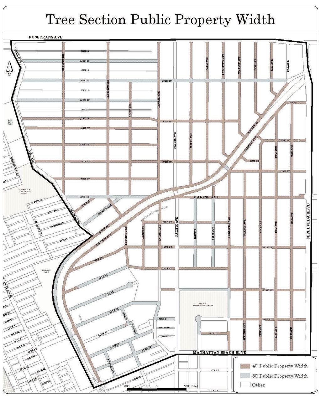
15 Page 13

16 The following diagrams illustrate improvements which may be required within the Tree Section. Page 14
.")
17 This diagram illustrates improvements on non-standard streets (ie. no improved curb, gutter and sidewalk). These areas are generally not located within the Tree Section, with some exceptions. Page 15
18 S ubmittal and Process Requirements SUBMITTAL The following items may be required for an Encroachment Permit for private development on the public property. The encroachment plan shall be included in the blueprint drawings submitted for development on private property if the Encroachment Permit is proposed in conjunction with a Building Permit Application. If no other building construction is being proposed, other than the construction in the encroachment area, drawings shall be submitted independently. An Encroachment Permit Application must also be completed and submitted along with the required plans. Plans that do not conform to the standards explained in this document can only be approved by the City Council after review by the City Parking and Public Improvements Commission (PPIC). It is recommended that conceptual plans be reviewed with a planner and the Public Works Department prior to the preparation of final plans. The following list consists of the general requirements for permit submittal. More or less information may be required depending on the complexity of the project. 1. FOUR (4) COPIES OF ARCHITECTURAL PLANS, with the following items: Site Plan, Elevation Drawings from the front and both sides, and Cross Section Views showing, dimensioning, and labeling the following: North arrow; Appropriate scale for legibility; Encroachment area boundaries, adjacent property lines, adjacent public right-of-way improvements (such as sidewalk, street, walk street, etc.), and adjacent street and walk street centerlines; Page 16
19 Elevation points of public walkway (edge of walkway, top of curb, etc.), neighboring private property grades, and finished surfaces (decks, patios, landings, etc); Elevation points of all structures (top of wall, top of fence, etc.), finished surface, existing grade, and finished grade; Location and elevation (finished floor, finished grade) of adjoining building on private property; Existing and proposed structures, fences, planters, and retaining walls; Proposed materials for all new construction; Existing and proposed steps, landings, decks, patios, handrails, and guardrails; Existing and proposed utilities within the public property including: water mains, house water meter boxes, sewer main lines, manholes and clean-outs, street lighting, and electrical power lines; Existing and proposed lighting; Existing and proposed landscaped areas; and Elevation points of landscaped areas (finished grade). Landscape Plan of proposed and existing-to-remain landscaping showing: All irrigation (sprinkler heads, backflow device, etc.); Types of landscaping (ground cover, shrub, tree, etc.), common and botanical names, size, and quantities of plants; and Percentage of proposed public property landscaping. Drainage Plan showing: Proposed drainage pattern; and That all site drainage will terminate at an approved public way location via a non-erosive device. 2. TOPOGRAPHIC/BOUNDARY SURVEY may also be required depending upon scope of project.. Page 17
20 FINAL APPROVAL An on-site inspection is required for development on public property and will be conducted by either the Building Division, Planning Division, or Public Works Department depending on the nature of the improvements. Prior to final inspection of encroachment improvements, the property owner will be required to provide the following: Insurance endorsement and certificate of insurance naming the City as additional insured; and A notarized Encroachment Permit Agreement that contains the terms and conditions of the permit approval. REVOCATION Permits may be modified or revoked by the City Council if the applicant fails to comply with any of the encroachment requirements. FURTHER INFORMATION For questions or further information regarding private construction on public property, please visit the City s website at contact the Planning Division at (310) , or visit the Community Development Counter Monday through Friday between the hours of 8:00 AM to 5:00 PM. Page 18
CITY OF MANHATTAN BEACH DEPARTMENT OF COMMUNITY DEVELOPMENT. TO: Parking and Public Improvements Commission
 Clay Curtin, Management Analyst (I the same walls at a maximum of 1 foot tall. Section 7.36.150 of the Municipal Code permits BY: Eric Haaland, Associate Planner right-of-way) between walkways leading
PLANNED UNIT DEVELOPMENT APPLICATION
 PLANNED UNIT DEVELOPMENT APPLICATION CITY OF THE DALLES Community Development Department 313 Court Street The Dalles, OR 97058 (541) 296-5481, ext. 1125 Fax (541) 298-5490 www.ci.the-dalles.or.us Date
SITE PLAN REVIEW APPLICATION
 SITE PLAN REVIEW APPLICATION CITY OF THE DALLES Community Development Department 313 Court Street The Dalles, OR 97058 (541) 296-5481, ext. 1125 Fax (541) 298-5490 www.ci.the-dalles.or.us Date Filed File#
FENCE & SHRUB INFORMATION
 City of Robbinsdale Building & Engineering Department 4100 Lakeview Ave N Robbinsdale, MN 55422 Phone 763-531-1268 Fax 763-531-1200 www.robbinsdalemn.com This handout is intended only as a guide and is
WASHINGTON TERRACE CITY ORDINANCE LANDSCAPING AMENDED
 WASHINGTON TERRACE CITY ORDINANCE 2018-09 LANDSCAPING AMENDED AN ORDINANCE OF THE CITY OF WASHINGTON TERRACE, UTAH, AMENDING CHAPTER 17.44 RELATED TO LANDSCAPING MAKING TECHNICAL CHANGES; SEVERABILITY;
CARVER COUNTY DIVISION OF PUBLIC WORKS LANDSCAPE POLICY. Adopted by the Carver County Board of Commissioners March 3, 2015
 CARVER COUNTY DIVISION OF PUBLIC WORKS LANDSCAPE POLICY Adopted by the Carver County Board of Commissioners March 3, 2015 Policy Statement Goals It is the goal of Carver County Public Works to provide
ARTICLE 9: LANDSCAPING AND FENCING REQUIREMENTS
 ARTICLE 9: LANDSCAPING AND FENCING REQUIREMENTS Section 9.01 Intent The intent of the landscaping requirements are to improve the appearance of lot areas and soften paved areas and buildings; to provide
KASPER. City of Georgetown, Texas PUD Planned Unit Development. December 30, 2015 Revised January 27, 2016
 KASPER City of Georgetown, Texas PUD Planned Unit Development December 30, 2015 Revised January 27, 2016 Applicant: Sentinel Land Company, LLC 4910 Campus Drive Newport Beach, CA Prepared by: SEC Planning
A/E REVIEW CHECKLIST SITE & LANDSCAPE
 A/E REVIEW CHECKLIST SITE & LANDSCAPE Reviewers should - Use Checklists when reviewing any type of VA construction project for the following disciplines: Architectural, Boiler Safety Devices Operation
Design Guidelines for Residential Subdivisions
 Design Guidelines for Residential Subdivisions Development Services 972-466-3225 cityofcarrollton.com This page intentionally left blank. Table of Contents Purpose... 1 Design Objectives... 1 Design Guidelines
HUNTSVILLE PHYSICAL SERVICES DEPARTMENT
 HUNTSVILLE PHYSICAL SERVICES DEPARTMENT URBAN DEVELOPMENT SITE PLAN CONTROL DRAWING DESIGN GUIDE April, 2000 (Revised June, 2003) TABLE OF CONTENTS Part A. General Information Page 1 Part B. Site Servicing
City of Placerville Planning Commission AGENDA REPORT ITEM 7
 Placerville, a Unique Historical Past Forging into a Golden Future City of Placerville Planning Commission REPORT ITEM 7 MEETING DATE: September 1, 2015 APPLICATION NO: 225 Placerville Drive Site Plan
F. Driveways. Driveways which provide access to off-street parking or loading from public streets shall comply with the following:
 Section 20.945.040 General Design Standards for Surface Parking Areas. A. Review Authority. Parking lot design and drainage shall be subject to review and approval of the City Transportation Manager. B.
SITE PLAN REVIEW ITEMS - REFERENCE CHECKLIST
 City of Seminole 9199 113 th Street N. Seminole, FL 33772 Ph: (727) 392-1966 Fx: (727) 319-6583 SITE PLAN REVIEW ITEMS - REFERENCE CHECKLIST Note: This checklist is designed to aid designers in the review
Chapter Landscaping and Screening
 Chapter 17-11 Landscaping and Screening 17-11-0050 Guide to the Chicago Landscape Ordinance...11-1 17-11-0100 Parkway Trees...11-1 17-11-0200 Vehicular Use Areas...11-2 17-11-0300 Trash Storage Area Screening...11-9
CITY OF KITCHENER CONDITIONS REQUIRED FOR ISSUANCE OF SITE PLAN APPROVAL
 CITY OF KITCHENER CONDITIONS REQUIRED FOR ISSUANCE OF SITE PLAN APPROVAL The following is a list of conditions requiring completion to the City s Satisfaction prior to Site Plan Approval being granted
LANDSCAPE ORDINANCE PASADENA PLANNING DEPARTMENT (713) FAX (713)
 FAX (713)") LANDSCAPE ORDINANCE PASADENA PLANNING DEPARTMENT (713) 475-5543 FAX (713) 477-1072 ARTICLE X. LANDSCAPING OF NONRESIDENTIAL SITES* Sec. 9-195. Applicability. (a) This article shall apply to the following:
LANDSCAPE ORDINANCE PASADENA PLANNING DEPARTMENT (713) 475-5543 FAX (713) 477-1072 ARTICLE X. LANDSCAPING OF NONRESIDENTIAL SITES* Sec. 9-195. Applicability. (a) This article shall apply to the following:
SITE PLAN REVIEW PROCESS
 BOWNE TOWNSHIP PO Box 35, 8240 Alden Nash Road, Alto, Michigan 49302 Ph. 616-868-6846 Fax 616-868-0110 http://www.bownetwp.org SITE PLAN REVIEW PROCESS 1. Application Form and Fee Schedule Site Plan Review
Title 11 Streets and Sidewalks
 Chapter 11.01 - Definitions Title 11 Streets and Sidewalks Low Impact Development (LID) - A stormwater and land use management strategy that strives to mimic predisturbance hydrologic processes of infiltration,
The Town Board of the Town of Vienna, County of Dane, State of Wisconsin, does ordain and adopt as follows.
 ORDINANCE DRIVEWAYS AND CULVERTS NO. 6-5-06 ORDINANCE CONCERNING DRIVEWAY AND CULVERT REQUIREMENTS 1-1-1 Driveway Permits; Culvert Requirements 1-1-2 Driveway and Culvert Location, Design and Construction
 PLANNING COMMISSION STAFF REPORT MEETING DATE: PROJECT NUMBER: ZONE: REQUEST: ADDRESS: APPLICANT: PREPARED BY: 6 July 2017 D-17-006 Commercial Corridorr Design Review Approval a parking lot expansion 26
DEPARTMENT OF PUBLIC WORKS & UTILITIES
 CITY OF PORT ANGELES DEPARTMENT OF PUBLIC WORKS & UTILITIES URBAN SERVICES STANDARDS AND GUIDELINES January 2017 Craig Fulton, P.E., Director TABLE OF CONTENTS "URBAN SERVICES STANDARDS AND GUIDELINES"
LANDSCAPE AND IRRIGATION PLAN PREPARATION GUIDELINES
 LANDSCAPE AND IRRIGATION PLAN PREPARATION GUIDELINES The Parks Planning and Development Division of the City of Modesto s Parks, Recreation and Neighborhoods Department is responsible for the task of reviewing
DCA , Stormwater Quality and Facilities Ordinance June 23, 2009
 PROPOSED NEW SECTION 10.486 Stormwater Quality and Detention Facilities, Public Streets. A. Purpose. It is the City s policy to maintain the natural hydrology and preserve water quality by mitigating the
TENTATIVE MAP CHECKLIST
 Business License 707.648.4357 www.cityofvallejo.net Central Permit Center 555 Santa Clara Street Vallejo CA 94590 Building 707.648.4374 Planning 707.648.4326 TENTATIVE MAP CHECKLIST Public Works/Engineering
ARTICLE RRCO RED ROCK CORRIDOR OVERLAY DISTRICT
 ARTICLE 11.10 RRCO RED ROCK CORRIDOR OVERLAY DISTRICT (adopted 11/22/2011 MC16-116-11) SECTIONS: 11.10.01 Intent 11.10.02 Boundaries of District 11.10.03 Development Standards 11.10.04 Variance 11.10.01
Article 7.05 Manufactured Home Park Districts
 Article Manufactured Home Park Districts.01 Intent The purpose of the MHP Manufactured Home Park District is to give recognition to the fact that manufactured homes can provide satisfactory living conditions
CRESCENT RESOURCES INC.
 CRESCENT RESOURCES INC. Due Diligence Checklist Project Name: Client: Project No. Date: 1 Survey Review survey for compliance with Crescent Resources, Inc. s Instructions to Surveyors (see below): All
PLANNING APPROVAL STAFF REPORT Date: November 17, 2011
 # 11 ZON2011-02680 PLANNING APPROVAL STAFF REPORT Date: November 17, 2011 NAME LOCATION Alabama Power Company East side of Navco Road 130 ± South of Columbus Avenue CITY COUNCIL DISTRICT District 4 PRESENT
Application for Site Plan Review
 Application for Site Plan Review City of Pontiac Office of Land Use and Strategic Planning 47450 Woodward Ave, Pontiac, MI 48342 T: 248.758.2800 F: 248.758.2827 Property/Project Address: Sidwell Number:
BUFFERS, TREE PROTECTION AND LANDSCAPING. Sec Purpose and Intent.
 ARTICLE 20 BUFFERS, TREE PROTECTION AND LANDSCAPING Sec. 20.1. Purpose and Intent. Trees improve air and water quality, reduce soil erosion, reduce noise and glare, provide habitat for desirable wildlife,
Sec Intent and purpose.
 1 of 5 10/12/2012 10:33 AM Hastings, Michigan, Code of Ordinances >> PART II - CODE OF ORDINANCES >> Chapter 90 - ZONING >> ARTICLE XII. - LANDSCAPING >> ARTICLE XII. - LANDSCAPING Sec. 90-1006. - Intent
SMALL LOT DESIGN STANDARDS. An Illustrated Working Draft for Test Implementation
 SMALL LOT DESIGN STANDARDS An Illustrated Working Draft for Test Implementation SMALL LOT DESIGN STANDARDS ILLUSTRATED WORKING FOR TEST IMPLEMENTATION OVERVIEW SMALL LOT CODE AMENDMENT & POLICY UPDATE
City of Oakley Zoning Assistant - Residential Fences Making Sense of the Residential Fence Code
 Planning Division 3231 Main Street Oakley, CA 94561 (925) 625-7000 www.oakleyinfo.com City of Oakley Zoning Assistant - Residential Fences Making Sense of the Residential Fence Code Regulations for residential
Bylaw A Bylaw to amend Bylaw 12800, as amended, The Edmonton Zoning Bylaw Amendment No. 2239
 Bylaw 17672 A Bylaw to amend Bylaw 12800, as amended, The Edmonton Zoning Bylaw Amendment No. 2239 WHEREAS City Council at its meeting of February 22, 2001, gave third reading to Bylaw 12800, as amended;
Landscape and fencing requirements of this Chapter shall apply to all new landscaped areas.
 Chapter 19.06. Landscaping and Fencing. Sections: 19.06.01. Purpose. 19.06.02. Required Landscaping Improvements. 19.06.03. General Provisions. 19.06.04. Landscaping Plan. 19.06.05. Completion of Landscape
CONFORMED AGREEMENT INCORPORATED REVISIONS PER AMENDMENT DATED: APRIL 2, 2013 FOR REFERENCE
 CONFORMED AGREEMENT INCORPORATED REVISIONS PER AMENDMENT DATED: APRIL 2, 2013 FOR REFERENCE CITY STREETS AS PART OF STATE HIGHWAYS GUIDELINES REACHED BY THE WASHINGTON STATE DEPARTMENT OF TRANSPORTATION
PLANNED DEVELOPMENT (MASTER PLAN & UNIT PLAN)
") Central Permit Center 555 Santa Clara Street Vallejo CA 94590 Business License Building Fire Prevention Planning Public Works 707.648.4310 707.648.4374 707.648.4565 707.648.4326 707.651.7151 PLANNED DEVELOPMENT
Central Permit Center 555 Santa Clara Street Vallejo CA 94590 Business License Building Fire Prevention Planning Public Works 707.648.4310 707.648.4374 707.648.4565 707.648.4326 707.651.7151 PLANNED DEVELOPMENT
LANDSCAPE STANDARDS PURPOSE AND INTENT OF LANDSCAPE ORDINANCE
 LANDSCAPE STANDARDS COMMUNITY DEVELOPMENT DEPARTMENT / PLANNING DIVISION 8130 Allison Avenue, La Mesa, CA 91942 Phone: 619.667-1177 Fax: 619.667-1380 PURPOSE AND INTENT OF LANDSCAPE ORDINANCE The regulations
Chapter LANDSCAPING
 Chapter 20.36 Sections: 20.36.010 Purpose 20.36.020 Applicability 20.36.030 Water Efficient Landscaping Ordinance 20.36.040 Landscape and Sprinkler Plans 20.36.050 Required Landscape Areas 20.36.060 Landscape
PRELIMINARY CONDITIONAL USE SUBMITTAL CHECKLIST REQUIREMENTS
 This checklist must accompany your submittal as the cover page. CONDITIONAL USE Application Submittal Checklist for PRELIMINARY AND FINAL APPROVAL Per Winter Park Land Development Code Sec. 58-90 PRELIMINARY
TOP TEN LIST OF COMMUNITY CONCERNS REGARDING PROPOSED AMENDMENTS TO CHAPTER 42
 TOP TEN LIST OF COMMUNITY CONCERNS REGARDING PROPOSED AMENDMENTS TO CHAPTER 42 1. Extend the urban area to Beltway 8 in stages, over say a three-year period, prioritizing development in transit and declining
For the purposes of this chapter, the words and terms used herein are defined as follows:
 City of Visalia Street Tree Ordinance 12.20.010 Purpose. The purpose of this chapter is to promote and regulate the planting, long term care, maintenance, and protection of street trees within the city.
CITY OF ZEELAND PLANNING COMMISSION
 APPLICATION FOR SITE PLAN REVIEW AND SPECIAL LAND USE Date City Official App. Filing Fee Rec'd ($350) NOTE TO APPLICANT: Please submit this application for Site Plan Review along with twenty (20) copies
Chapter YARDS AND SETBACKS
 Chapter 19.48 YARDS AND SETBACKS Sections: 19.48.010 Yards and setbacks Requirements generally. 19.48.020 Front yards Requirements generally. 19.48.030 Variable front setback lines. 19.48.040 Front yard
A BILL FOR AN ORDINANCE TO AMEND CHAPTER 9, KAUAI COUNTY CODE 1987, RELATING TO STREET REQUIRE:MENTS FOR SUBDIVISIONS
 ORDINANCE NO. BILL NO. { vy"yj1j A BILL FOR AN ORDINANCE TO AMEND CHAPTER 9, KAUAI COUNTY CODE 1987, RELATING TO STREET REQUIRE:MENTS FOR SUBDIVISIONS BE IT ORDAINED BY THE COUNCIL OF THE COUNTY OF KAUA'I,
ARTICLE 6: Special and Planned Development Districts
 ARTICLE 6: Special and Planned Development Districts 6-10 Traditional Neighborhood Development (TND) District 6-10.10 Purpose and Intent The Traditional Neighborhood Development (TND) District provides
Request Change in Nonconformity. Staff Recommendation Approval. Staff Planner Jonathan Sanders
 Applicant & Owner Public Hearing April 11, 2018 City Council Election District Beach Agenda Item 5 Request Change in Nonconformity Staff Recommendation Approval Staff Planner Jonathan Sanders Location
SITE PLAN REVIEW APPLICATION AND CHECKLIST
 SITE PLAN REVIEW APPLICATION AND CHECKLIST PROJECT SUMMARY: Project Name: City/ETA Location: City ETA (Application fee & number of copies needed are based on location) Property Location (Legal Description
CHAPTER BEAUTIFICATION AND LANDSCAPE MANAGEMENT
 APPLICATIONS FOR BEAUTIFICATION GRANTS (STARTING FISCAL YEAR 2017-2018) MUST ADHERE TO THE REQUIREMENTS OF RULE CHAPTER 14-40, FLORIDA ADMISTRATIVE CODE Including the pending revisions shown below CHAPTER
SUBMITTAL REQUIREMENTS: FINAL PLAN REVIEW- PROJECT DEVELOPMENT PLAN (PDP)
") 1) Application form and filing fee. Application Form.pdf Development Review Guide STEP 6 of 8 SUBMITTAL REQUIREMENTS: FINAL PLAN REVIEW- PROJECT DEVELOPMENT PLAN (PDP) 2) Transportation Development Review
1) Application form and filing fee. Application Form.pdf Development Review Guide STEP 6 of 8 SUBMITTAL REQUIREMENTS: FINAL PLAN REVIEW- PROJECT DEVELOPMENT PLAN (PDP) 2) Transportation Development Review
Rootstown Township Zoning Resolution 8/26/99. CHAPTER 430 Landscaping And Screening Requirements
 430.01 Purpose. 430.02 Landscaping along the street frontage. 430.03 Screening and landscaping of parking lots 430.04 Screening and buffering when lot abuts a residential district. 430.05 Screening of
The following specific definitions shall apply to the landscaping and screening regulations contained in this article:
 ARTICLE XII. LANDSCAPING Sec. 5-421. Purpose. The purpose of landscaping and screening requirements is to improve certain setback and yard areas, including off-street vehicular parking and open-lot sales
5.1 Commercial and Industrial Development. (Effective April 1, 2006)
") 5.1 Commercial and Industrial Development. (Effective April 1, 2006) A. Applicability: The requirements of this section (5.10) shall apply to all uses within the LB Local Business; HB Highway Business;
5.1 Commercial and Industrial Development. (Effective April 1, 2006) A. Applicability: The requirements of this section (5.10) shall apply to all uses within the LB Local Business; HB Highway Business;
5.7 Design Criteria for the Private Realm Organization of Private Realm Design Standards and Guidelines Guidelines vs.
 5.7 Design Criteria for the Private Realm The Private Realm (shown in Exhibit 5.7a) includes the privately owned property not included in the Setback Realm described in the previous section. It encompasses
Nick Sigmund, Sr. Zoning Officer
 Nick Sigmund, Sr. Zoning Officer Wisconsin Department of Natural Resources Administrative Code NR 115 under the authority of Wisconsin Statute 59.692, establishes and provides that shoreland zoning regulations
4030 COMMERCIAL (C AND CM)
") 4030 COMMERCIAL (C AND CM) 4030.10 Intent and Purpose The C and CM districts are intended to permit the range of commercial uses in areas which are appropriate for such uses consistent with the General
4030 COMMERCIAL (C AND CM) 4030.10 Intent and Purpose The C and CM districts are intended to permit the range of commercial uses in areas which are appropriate for such uses consistent with the General
#8) T-1409 CENTENNIAL & LAMB TENTATIVE MAP
 T-1409 CENTENNIAL & LAMB TENTATIVE MAP") #8) T-1409 CENTENNIAL & LAMB TENTATIVE MAP STAFF REPORT To: Planning Commission Meeting Date: June 14, 2017 Item: T-1409 Prepared By: Robert Eastman GENERAL INFORMATION: Applicant: Property Owner(s): Requested
#8) T-1409 CENTENNIAL & LAMB TENTATIVE MAP STAFF REPORT To: Planning Commission Meeting Date: June 14, 2017 Item: T-1409 Prepared By: Robert Eastman GENERAL INFORMATION: Applicant: Property Owner(s): Requested
Rezoning Transportation Analysis Petition Number: General Location Identifier:
 From: Kelsie Anderson, PE Kelsie.Anderson@charlottenc.gov 704-432-5492 Staff Reviewer: Kory Hedrick, PE, PMP Khedrick@charlottenc.gov 704-432-6511 CDOT s review of this rezoning petition is intended to
CITY OF KEIZER MASTER PLAN APPLICATION & INFORMATION SHEET
 CITY OF KEIZER MASTER PLAN APPLICATION & INFORMATION SHEET PRE-APPLICATION CONFERENCE Prior to the actual filing of a Master Plan application, it is strongly recommended that the applicant contact Planning
MIXED-USE ZONING DISTRICT DESIGN GUIDELINES
 MIXED-USE ZONING DISTRICT DESIGN GUIDELINES In addition to the development regulations contained in the Mixed-Use Zoning District, design guidelines are presented here to provide an added level of definition
PRELIMINARY PLAT DESIGN REQUIREMENTS Updated 4/8/2016
 PRELIMINARY PLAT DESIGN REQUIREMENTS Updated 4/8/2016 The following items are required for the preliminary plat. Numbers correspond with those on the example preliminary plat. RENO COUNTY SUBDIVISION REQUIREMENTS
Required Internal Landscaping Percentage of Ground Cover in Living Materials Percentage of Tree Size
 CHAPTER 12-24 LANDSCAPE STANDARDS 12-24-101 Purpose 12-24-102 Landscaping Required 12-24-103 Parking Lot Screening 12-24-104 Parking Lot Trees 12-24-105 12-24-106 Landscaped Setbacks Buffers 12-24-107
CHAPTER 20: INSTITUTIONAL USE DEVELOPMENT STANDARDS
 CHAPTER 20: INSTITUTIONAL USE DEVELOPMENT STANDARDS ARTICLE 1: GENERAL INSTITUTIONAL USE STANDARDS 320-01. Application The provisions of this Chapter shall apply to the following uses in any zone: (e)
(e) No person shall install, construct or maintain a fence or hedge on any property in the Town of Colma except in compliance with the following:
 No person shall install, construct or maintain a fence or hedge on any property in the Town of Colma except in compliance with the following:") (d) Buildings and structures may be developed in the "T" Zone, subject to a Use Permit, provided the building or structure is supported on a foundation system that will not prevent the development of covered,
(d) Buildings and structures may be developed in the "T" Zone, subject to a Use Permit, provided the building or structure is supported on a foundation system that will not prevent the development of covered,
ARTICLE VI: SITE PLAN REVIEW
 Section 6.01 - Site Plan Review (All Districts) ARTICLE VI: SITE PLAN REVIEW Site plans give the Planning commission an opportunity to review development proposals in a concise and consistent manner. The
City of Yelm. Tahoma Terra Final Master Plan Development Guidelines. Table of Contents
 City of Yelm Tahoma Terra Final Master Plan Development Guidelines Table of Contents Table of Contents... 1 Purpose... 2 Low Density Residential (R4-6)... 3 Moderate Density Residential (R6-10)... 5 Neighborhood
GUIDELINES FOR PERMEABLE SIDEWALK-LANDSCAPING PERMIT
 GUIDELINES FOR PERMEABLE SIDEWALK-LANDSCAPING PERMIT Green spaces are vital to San Francisco s quality of life as they provide a range of environmental benefits and bring beauty to our neighborhoods and
PARKLET PROPOSAL PACKAGE & PROCESS
 500.3 I PARKLETS The term parklet refers to a small temporary constructed seating or community gathering area over an on-street parking space or an extension of the sidewalk into the operating State highway
ARTICLE IX SPECIAL PERMIT USES
 ARTICLE IX SPECIAL PERMIT USES All special permit uses cited in Article IX and Attachment A of this Ordinance or any other Section of this Ordinance shall be subject to Site Plan Review. The procedures
Request Alternative Compliance to the prescribed criteria of the Oceanfront Resort District Form-Based Code. Staff Planner Kristine Gay
 Applicant/Owner Ocean Rental Properties, LLC Public Hearing April 13, 2016 City Council Election District Beach Agenda Item 1 Request Alternative Compliance to the prescribed criteria of the Oceanfront
Preserving Green Streetscape Character on Hillside Drive
 STAFF REPORT ACTION REQUIRED Preserving Green Streetscape Character on Hillside Drive Date: February 19, 2014 To: From: Toronto and East York Community Council Deputy City Manager, Cluster B Wards: Toronto-Danforth,
CITY OF SAN MATEO ORDINANCE NO
 CITY OF SAN MATEO ORDINANCE NO. 2012-4 AMENDING SECTION 27.38.090, OPEN SPACE REQUIREMENTS, OF CHAPTER 27.38, CBD DISTRICTS-CENTRAL BUSINESS DISTRICT, SECTION 27.64.023, PARKING PROHIBITED ON LAWNS, FLOWERS,
8 ARTICLE EIGHT LANDSCAPING AND SCREENING
 8 ARTICLE EIGHT LANDSCAPING AND SCREENING STANDARDS 801 Purpose The Landscaping and Screening Regulations provide additional guidance on the development of sites within Storm Lake by addressing landscaping
NOW, THEREFORE, THE CITY COUNCIL OF THE CITY OF SIMI VALLEY DOES ORDAIN AS FOLLOWS:
 ORDINANCE NO. 1241 AN ORDINANCE OF THE CITY COUNCIL OF THE CITY OF SIMI VALLEY APPROVING A SIMI VALLEY MUNICIPAL CODE TEXT AMENDMENT (Z-S-721) TO ALLOW THE USE OF ARTIFICIAL TURF IN MULTI-FAMILY RESIDENTIAL
BUILDING SCALE AND SETBACKS 5 ELEMENTS:... 5 FAÇADES (COMMERCIAL/RESIDENTIAL) 5
 5") VISION STATEMENT 3 UTILIZATION OF THE GUIDELINES 3 IMPLEMENTATION 3 PROCEDURES FOR DESIGN REVIEW 3 LAND USE AND ZONING 4 LAND USE 4 ELEMENTS:... 4 ZONING 4 ELEMENTS:... 4 BUILDING SCALE AND SETBACKS 5
VISION STATEMENT 3 UTILIZATION OF THE GUIDELINES 3 IMPLEMENTATION 3 PROCEDURES FOR DESIGN REVIEW 3 LAND USE AND ZONING 4 LAND USE 4 ELEMENTS:... 4 ZONING 4 ELEMENTS:... 4 BUILDING SCALE AND SETBACKS 5
City of Kelowna Consolidated Zoning Bylaw No. 8000
 Section 7 Landscaping and Screening 7.1 Required Landscaping 7.1.1 The minimum level of landscaping required in each zone along all front, rear and side yards shall be determined from the Minimum Landscape
Deb Grube, Sr. Zoning Officer
 Deb Grube, Sr. Zoning Officer Wisconsin Department of Natural Resources Administrative Code NR 115 under the authority of Wisconsin Statute 59.692, establishes and provides that shoreland zoning regulations
Design Review Application *Please call prior to submittal meeting to determine applicable fees*
 CITY OF EAGLE 660 E. Civic Lane, Eagle, ID 83616 Phone#: (208) 939-0227 Fax: (208) 938-3854 Design Review Application *Please call prior to submittal meeting to determine applicable fees* FILE NO.: CROSS
GENERAL LANDSCAPE PROVISIONS. The following landscape provisions shall be adhered to by all land uses unless otherwise noted:
 CHAPTER 1.18 Sections: 1.18.005 Purpose. 1.18.010 Landscaping, Buffering, and Fencing Improvements Required. 1.18.015 General Landscape Provisions. 1.18.020 Landscaping Plan. 1.18.025 Single-Family Dwellings
The planning and zoning board considered amending the zoning code to address plantings and alteration of the swale.
 MIAMI SHORES DEPARTMENT OF PLANNING & ZONING 10050 NE 2 nd Avenue Miami Shores FL 33037-2304 www.miamishoresvillage.com David A. Dacquisto AICP, Director Main Number: 305-795-2207 Fax Number: 305-756-8972
UTILITIES - SERVICES. Chapter 648 WATER - USE - REGULATION
 UTILITIES - SERVICES Chapter 648 WATER - USE - REGULATION CHAPTER INDEX Article 1 INTERPRETATION 648.1.1 City - defined 648.1.2 City water supply system - defined 648.1.3 Commissioner - defined 648.1.4
Sanford/Lee County Technical Review Committee (TRC) DEADLINES & MEETING DATES
 DEADLINES & MEETING DATES") Sanford/Lee County Technical Review Committee (TRC) DEADLINES & MEETING DATES The following 2019 information is based on the information available to staff at the time of creation. Dates & time may change
Sanford/Lee County Technical Review Committee (TRC) DEADLINES & MEETING DATES The following 2019 information is based on the information available to staff at the time of creation. Dates & time may change
Preliminary Development Plan 07/ /2
 OWENSBORO METROPOLITAN PLANNING COMMISSION Preliminary Development Plan 07/06 120 1/2 Development Information The table at right refers to the application materials required for submission, unless otherwise
PLANNING BOARD HEARING Miami Shores Village Town Hall Council Chambers NE 2 nd Avenue Miami Shores Workshop Date April 24, 2014
 MIAMI SHORES VILLAGE DEPARTMENT OF PLANNING & ZONING 10050 NE 2 nd Avenue Miami Shores FL 33037-2304 www.miamishoresvillage.com David A. Dacquisto AICP, Director dacquistod@miamishoresvillage.com Main
LANDSCAPING. Design. Development of the site shall not unreasonably impair the ability of adjoining properties to utilize solar energy.
 Landscape design is an integral component of Site Planning and Building. The current pattern of walkways, driveways and landscape elements such as fences, hedges, and retaining walls in the neighborhood
ARLINGTON COUNTY, VIRGINIA
 ARLINGTON COUNTY, VIRGINIA County Board Agenda Item Meeting of January 27, 2007 DATE: January 12, 2007 SUBJECT: U-3101-04-2 Use Permit Review for drive-through facilities; premises known as 5222 Lee Highway
Venice Pumping Plant Dual Force Main Project Draft EIR
 City of Los Angeles 5.9 LAND USE PLANS 5.9.1 Environmental Setting Venice Pumping Plant Dual Force Main Project Draft EIR The Project lies within the bounds of Los Angeles County and the City of Los Angeles.
SUBDIVISION, PLANNED UNIT DEVELOPMENT, PLANNING APPROVAL, REZONING & SIDEWALK WAIVER STAFF REPORT Date: February 7, 2013
 SUBDIVISION, PLANNED UNIT DEVELOPMENT, PLANNING APPROVAL, REZONING & SIDEWALK WAIVER STAFF REPORT Date: February 7, 2013 APPLICANT NAME SUBDIVISION NAME DEVELOPMENT NAME LOCATION S. E. Cemeteries of AL
CITY OF LAGUNA BEACH COMMUNITY DEVELOPMENT DEPARTMENT STAFF REPORT DESIGN REVIEW BOARD IBOARD OF ADJUSTMENT Coast Highway APN
 CITY OF LAGUNA BEACH COMMUNITY DEVELOPMENT DEPARTMENT STAFF REPORT HEARING DATE: October 13,2011 TO: DESIGN REVIEW BOARD IBOARD OF ADJUSTMENT CASE: Variance 7717 Design Review 11-163 Coastal Development
Chapter PEDESTRIAN COMMERCIAL (PC) ZONING DISTRICT
 ZONING DISTRICT") Chapter 11-17 PEDESTRIAN COMMERCIAL (PC) ZONING DISTRICT Sections: 11-17-01 GENERAL PURPOSE 11-17-02 PERMITTED BUILDING TYPES 11-17-03 USES PERMITTED WITH DESIGN REVIEW 11-17-04 USES PERMITTED BY CONDITIONAL
Chapter 11-17 PEDESTRIAN COMMERCIAL (PC) ZONING DISTRICT Sections: 11-17-01 GENERAL PURPOSE 11-17-02 PERMITTED BUILDING TYPES 11-17-03 USES PERMITTED WITH DESIGN REVIEW 11-17-04 USES PERMITTED BY CONDITIONAL
S I T E P L A N A N D A R C H I T E C T U R A L R E V I E W A P P L I C A T O I N
 P l a n n i n g D e p a r t m e n t S I T E P L A N A N D A R C H I T E C T U R A L R E V I E W A P P L I C A T O I N 1. APPLICANT INFORMATION (If a corporation, list all principals) Name Address City
KEY MAP DEVELOPMENT PERMIT AREA MAP. Sunnymede North Sub-Area Plan
 Richmond Official Community Plan BROADMOOR AREA SUNNYMEDE NORTH SUB-AREA PLAN Bylaw 7100 Schedule 2.6C SUNNYMEDE NORTH SUB-AREA PLAN SUNNYMEDE NORTH SUB-AREA PLAN SUNNYMEDE NORTH SUB-AREA PLAN KEY MAP
Project phasing plan (if applicable) 12 copies of site plan
 12 copies of site plan") SITE PLAN REVIEW PERMIT APPLICATION City of Grand Haven, 11 N. Sixth Street, Grand Haven, MI 49417 Phone: (616) 847-3490 Fax: (616) 844-2051 Website: www.grandhaven.org 1. Project Information Address/location
SITE PLAN REVIEW PERMIT APPLICATION City of Grand Haven, 11 N. Sixth Street, Grand Haven, MI 49417 Phone: (616) 847-3490 Fax: (616) 844-2051 Website: www.grandhaven.org 1. Project Information Address/location
Checklists. Project Name: Location: File Number: Date of Submittal: Reviewer: Date: Applicant: Contact Name: Phone Number:
 Applicant: Contact Name: Phone Number: Email: Project Name: Location: File Number: Date of Submittal: Reviewer: Date: Concept Plan Requirements: I. General Project Information 1. Address or parcel number
III. PROJECT DESCRIPTION
 III. PROJECT DESCRIPTION LOCATION AND BOUNDARIES The City of Manhattan Beach is located in the South Bay region of Los Angeles County, California, approximately 2 miles south of the Los Angeles International
The Maryland-National Capital Park and Planning Commission Prince George's County Planning Department Development Review Division
 The Maryland-National Capital Park and Planning Commission Prince George's County Planning Department Development Review Division 301-952-3530 Note: Staff reports can be accessed at www.mncppc.org/pgco/planning/plan.htm.
Kingfisher Planned Development (PLNSUB ) and Special Exception (PLNPCM ) Planned Development and Special Exception
 and Special Exception (PLNPCM ) Planned Development and Special Exception") Staff Report PLANNING DIVISION COMMUNITY & ECONOMIC DEVELOPMENT To: From: Salt Lake City Planning Commission Maryann Pickering, Principal Planner (801) 535-7660 Date: October 22, 2014 Re: Kingfisher Planned
Staff Report PLANNING DIVISION COMMUNITY & ECONOMIC DEVELOPMENT To: From: Salt Lake City Planning Commission Maryann Pickering, Principal Planner (801) 535-7660 Date: October 22, 2014 Re: Kingfisher Planned
FIRE PREVENTION OFFICE Placer Hills Fire Protection District NEW PROJECT GUIDELINES
 Established 1949 FIRE PREVENTION OFFICE Placer Hills Fire Protection District NEW PROJECT GUIDELINES The following are guidelines for new development. Any submitted plans must comply with these guidelines,
MIDTOWN MIXED-USE VILLAGE. TECHNICAL DATA SHEET COMPONENT C-1 FOR PUBLIC HEARING - PETITION NUMBER Project No RZ1.1. Issued.
 N MIDTOWN MIXED-USE VILLAGE TECHNICAL DATA SHEET COMPONENT C- FOR PUBLIC HEARING - PETITION NUMBER 04-00 Project No. 496 Issued Revised SCALE: " = 0' N 0 0 0 40 RZ. c GENERAL PROVISIONS: a. SITE LOCATION.