CLOSURE PLAN. CFR (b) Fly Ash Reservoir II. Cardinal Plant Brilliant, Ohio. August, 2016
|
|
|
- Darcy Lambert
- 6 years ago
- Views:
Transcription
1 CLOSURE PLAN CFR (b) Fly Ash Reservoir II Cardinal Plant Brilliant, Ohio August, 2016 Prepared for: Cardinal Operating Company Cardinal Plant Brilliant, Ohio Prepared by: Geotechnical Engineering Services American Electric Power Service Corporation 1 Riverside Plaza Columbus, OH GERS

2
3 CONTENTS 1.0 OBJECTIVE DESCRIPTION OF THE CCR UNIT DESCRIPTION OF CLOSURE PLAN (b)(1)(i) CLOSURE IN PLACE (b)(1)(iii) CLOSURE PERFORMANCE STANDARDS (d)(1) DRAINING AND STABILIZING OF THE SURFACE IMPOUNDMENT (d)(2) FINAL COVER SYSTEM (d)(3) ESTIMATE OF MAXIMUM CCR VOLUME (b)(1)(iv) ESTIMATE OF LARGEST AREA OF CCR REQUIRING COVER (b)(1)(v) CLOSURE SCHEDULE (b)(1)(vi)... 4 Attachment A: Excerpts from 2012 Cardinal FAR II Closure Plan iii
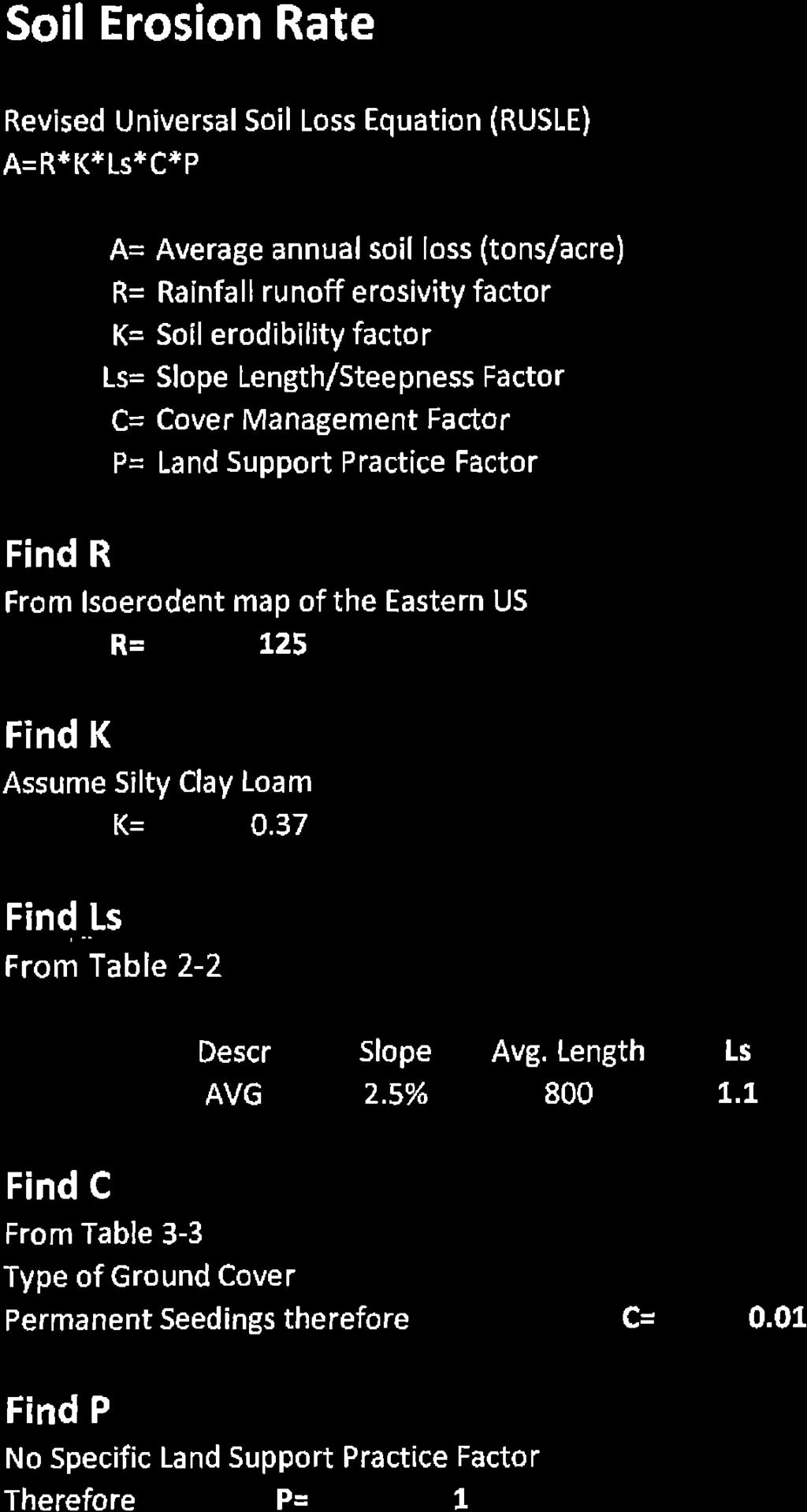
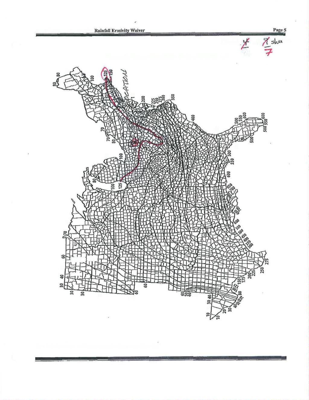
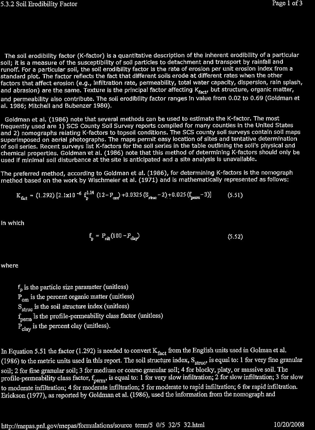
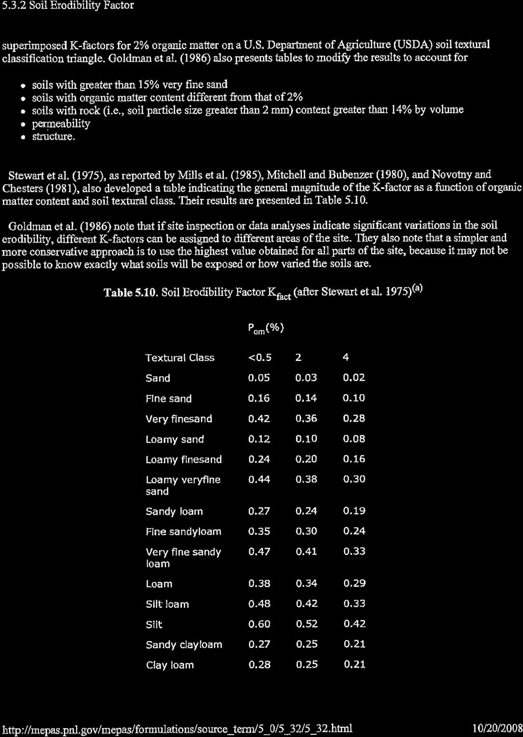
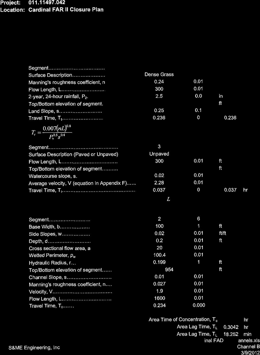
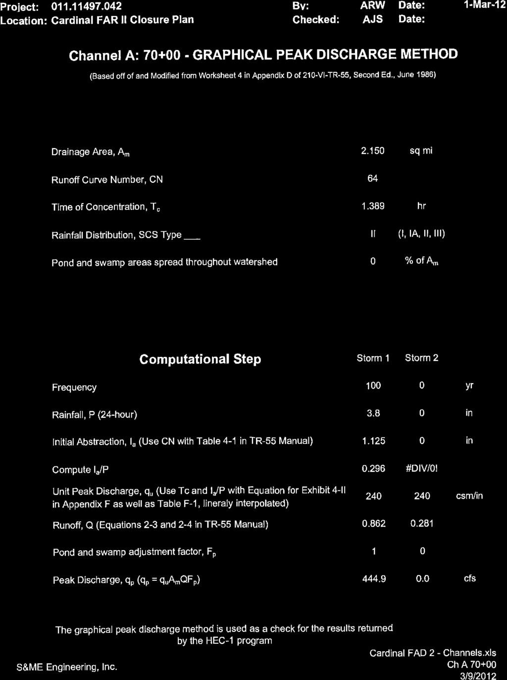
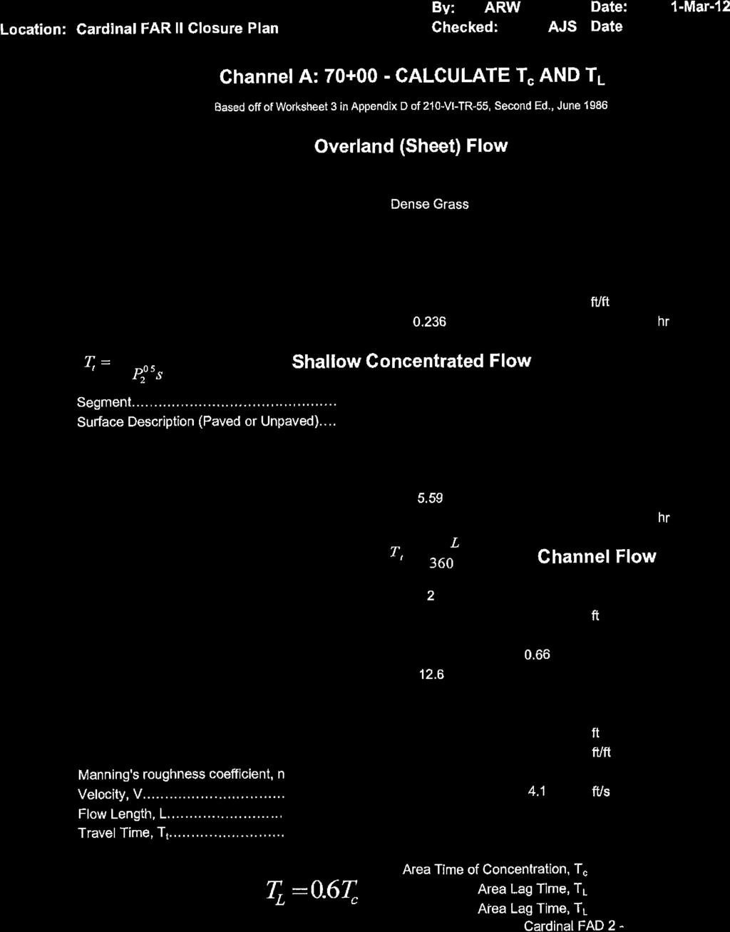
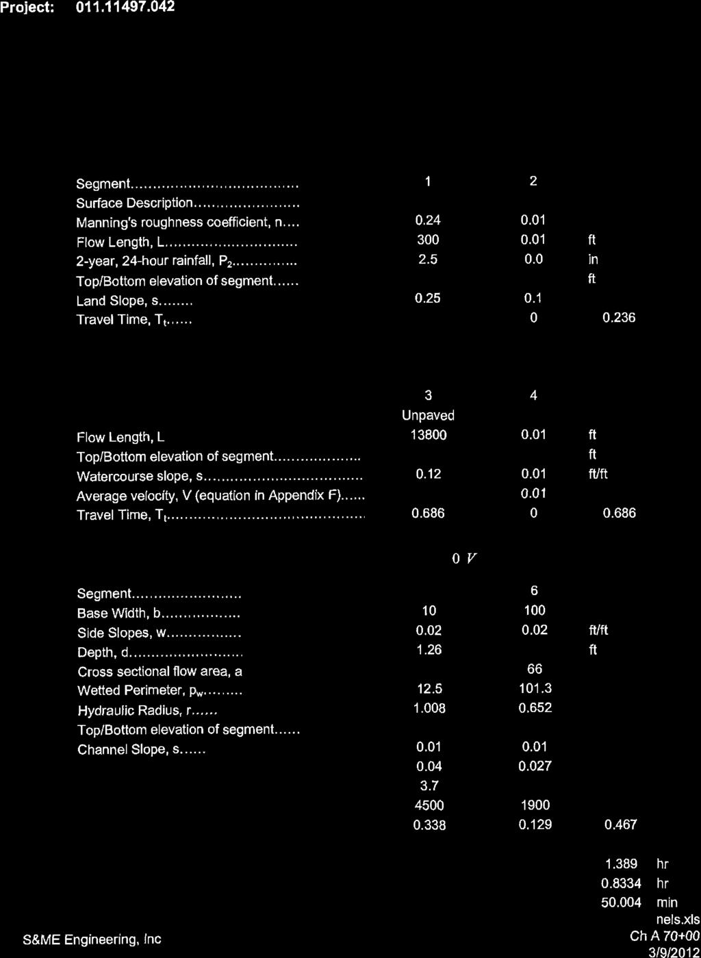
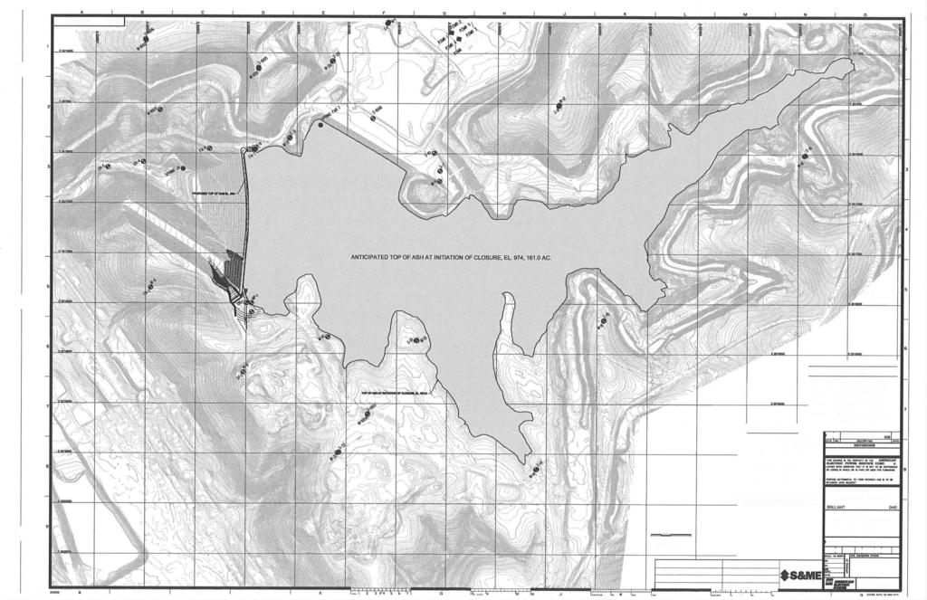
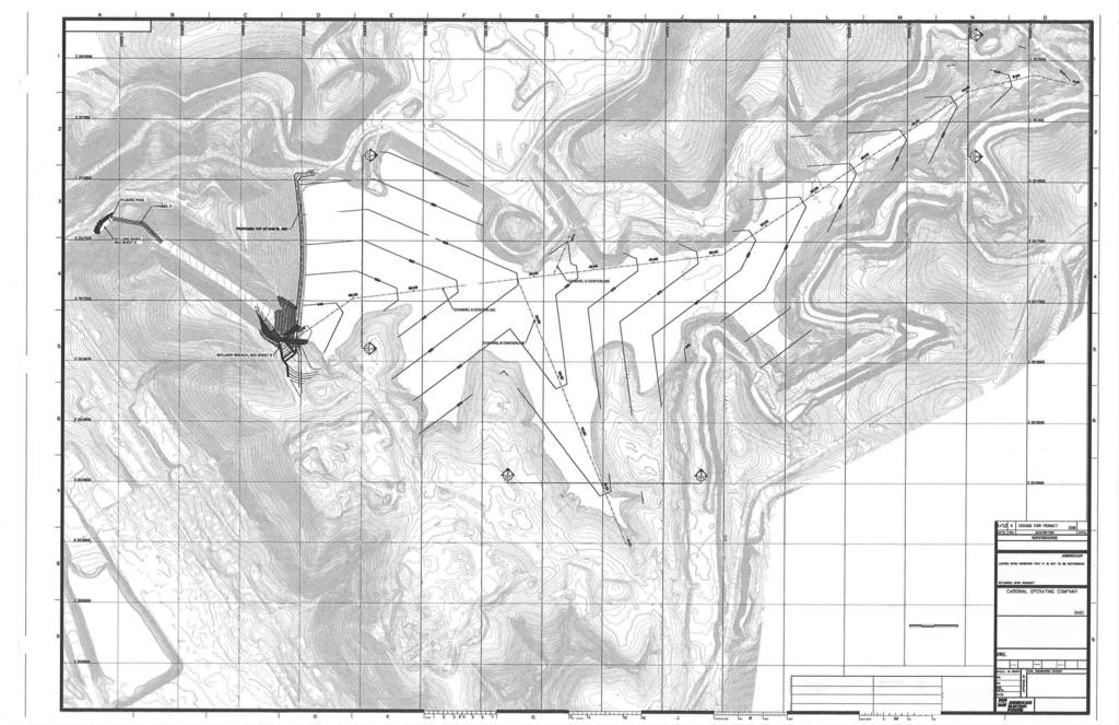
4 1.0 OBJECTIVE This report was prepared by AEP Geotechnical Engineering Services (GES) section to fulfill requirements of CFR (b) for Closure Plans of Existing CCR Surface Impoundments. 2.0 DESCRIPTION OF THE CCR UNIT The Cardinal Power Plant in Wells Township, Jefferson County, near the town of Brilliant in eastern Ohio. It is owned by Buckeye Power and AEP Generation Resources (GENCO) and is operated by Cardinal Operating Company. The facility operates two surface impoundments for storing CCR; the Bottom Ash Complex and Cardinal Fly Ash Reservoir II (FAR II) Dam. This report deals with the closure plan for the Fly Ash Pond FAR II. The FAR II Dam is a valley filled dam with a unique structure whose current configuration is the result of the original earth fill dam and two separate raisings. The original earth fill dam (Stage 1) consisted of a 180 feet high arched earth embankment incorporating a zoned cross section. At 925 feet NGVD, the dam featured a 70 foot wide by 1,055 feet long crest. The maximum operating pool that could be achieved with the original configuration was El In 1997, the original dam was raised, referred to as Stage 2. Following this raising, the dam was 237 feet high with a 30 foot wide crest. In 2013, the dam was raised 13 feet using back to back MSE walls, bringing the dam into its current, Stage 3 configuration. The principal features of the typical section are the MSE wall themselves and a vinyl sheet pile wall extending from the existing clay core to the top of the PMF flood level for seepage cutoff purposes. The FAR II Dam received sluiced fly ash and waste water from the plant via the bottom ash pond. 3.0 DESCRIPTION OF CLOSURE PLAN (b)(1)(i) [A narrative description of how the CCR unit will be closed in accordance with this section] The FAR II Dam will be closed by closure in place. The closure will consist of re grading the existing onsite materials and the installation of an impermeable cap with vegetative cover. The existing surface will be graded to achieve a gently sloping surface to promote surface water runoff. The regraded surface will be covered with a flexible geomembrane system and 2 feet of soil fill consisting of an 18 soil infiltration layer and 6 of earthen material that is capable of sustaining native plant growth. The surface soil will be seeded and mulched to promote the growth of a vegetative cover. 4.0 CLOSURE IN PLACE (b)(1)(iii) [If closure of the CCR unit will be accomplished by leaving the CCR in place, a description of the final cover system, designed in accordance with paragraph(d) of this section, and the methods and procedures to be used to install the final cover. The closure plan must also discuss how the final cover system will achieve the performance standards specified in paragraph (d) of this section.] The final cover system will consist of a flexible geomembrane that will have a permeability that is less than or equal to the permeability of the natural subsoils and is no greater than 1 x 10 5 cm/sec. The geomembrane will be installed directly over the graded CCR material. Over the geomembrane will be installed an infiltration layer consisting of 18 of earthen material and an erosion layer consisting of 6 of earthen material that is capable of sustaining native plant growth. The final cover will be seeded and Page 1 of 4
5 mulched to promote growth of a vegetative cover. The final cover slope will be a minimum of 2% and will convey water to a NPDES permitted outfall. Prior to installation of the final cover system the impoundment be draining of the free water within the, the ash and soil material will be regarded to provide a stable subgrade. 4.1 CLOSURE PERFORMANCE STANDARDS (d)(1) SECTION (d)(1)(i) [Control, minimize or eliminate, the maximum extent feasible, post closure infiltration of liquids into the waste and releases of CCR, leachate, or contaminated run off to the ground or surface waters or to the atmosphere.] The final cover system will cover the CCR material and will have a permeability that is less than or equal to the permeability of the natural subsoils and is no greater than 1 x 10 5 cm/sec SECTION (d)(1)(ii) [Preclude the probability of future impoundment of water, sediment, or slurry.] The impoundment will be graded with minimum side slopes of 2% to prevent the ponding of water with channels graded to drain. The dam will be lowered to preclude the future impoundment of water, sediment, or slurry SECTION (d)(1)(iii) [Include measures that provide for major slope stability to prevent the sloughing or movement of the final cover system during the closure and post closure care period.] The final cover system will be graded with side slopes with a minimum of 2% slope and a maximum 3:1 slope with channels provided to drain stormwater. The final configuration of the impoundment will meet the stability requirements to prevent the sloughing or movement of the final cover system during the closure and post closure care period SECTION (d)(1)(iv) [Minimize the need for further maintenance of the CCR unit.] The impoundment will be vegetated to prevent erosion. Maintenance of the final cover system will include mowing SECTION (d)(1)(v) [Be completed in the shortest amount of time consistent with recognized and generally accepted good engineering practices.] The CCR unit will be closed in a multi year phased manner as liquids are removed and areas are stabilized. There is currently no schedule for closure of this CCR unit. Page 2 of 4
6 4.2 DRAINING AND STABILIZING OF THE SURFACE IMPOUNDMENT (d)(2) [The owner or operator of a CCR surface impoundment or any lateral expansion of a CCR surface impoundment must meet the requirements of paragraph (d)(2)(i) and (ii) of this section prior to installing the final cover system required under paragraph (d)(3) of this section.] SECTION (d)(2)(i) [Free liquids must be eliminated by removing liquid wastes or solidifying the remaining wastes and waste residue.] As part of closure of the CCR unit, all free water will be removed and the ash dewatered to sufficient depth to provide a stable surface. All water discharge will be in accordance with the NPDES permit SECTION (d)(2)(ii) [Remaining waste must be stabilized sufficient to support the final cover system.] The remaining waste that make up the subgrade of the final cover system will be stabilized by removal of liquids to sufficient depth and providing bridging as necessary. 4.3 FINAL COVER SYSTEM (d)(3) [If a CCR unit is closed by leaving CCR in place, the owner or operator must install a final cover system that is designed to minimize infiltration and erosion, and at a minimum, meets the requirements of paragraph (d)(3)(i) of this section, or the requirements of the alternative final cover system specified in paragraph (d)(3)(ii) of this section. The final cover system must be designed and constructed to meet the criteria in paragraphs (d)(3)(i)(a) through (D) of this section. The design of the final cover system must be included in the written closure plan.] The final cover system will consist of a flexible geomembrane that will have a permeability that is less than or equal to the permeability of the natural subsoils and is no greater than 1 x 10 5 cm/sec. The geomembrane will be installed directly over the graded CCR material. Over the geomembrane will be installed an infiltration layer consisting of 18 of earthen material and an erosion layer consisting of 6 of earthen material that is capable of sustaining native plant growth. The final cover will be seeded and mulched to promote growth of a vegetative cover. The final cover slope will be a minimum of 2% and will convey water to a NPDES permitted outfall. The final cover slope will be a minimum of 2% to accommodate settling and subsidence. 5.0 ESTIMATE OF MAXIMUM CCR VOLUME (b)(1)(iv) [An estimate of the maximum inventory of CCR ever on site over the active life of the CCR unit.] The estimated maximum CCR volume ever on site is approx. 8,200 acre feet. 6.0 ESTIMATE OF LARGEST AREA OF CCR REQUIRING COVER (b)(1)(v) [An estimate of the largest area of CCR unit ever requiring a final cover Page 3 of 4
7 The largest area of the CCR unit ever requiring a final cover is 161 acres. 7.0 CLOSURE SCHEDULE (b)(1)(vi) [A schedule for completing all activities necessary to satisfy the closure criteria in the section, including an estimate of the year in which all closure activities for the CCR unit will be completed. The schedule should provide sufficient information to describe the sequential steps that will be taken to close the CCR unit, including identification of major milestones such as coordinating with and obtaining necessary approvals and permits from other agencies, the dewatering and stabilization phases of the CCR surface impoundment closure, or installation of the final cover system, and the estimated timeframes to complete each step or phase of the CCR unit closure. Engineering and Design for the Closure of the FAR II Dam were prepared in Initial permits were submitted to Ohio Environmental Protection Agency (OEPA) Division of Waste Management (DWM) in Attachment A includes the submitted closure plan for the FAR II Pond. A Permit for Modification of the Dam associated with the closure was submitted to ODNR Division of Water (DOW) Dam Safety Program in 2012 and a permit was issued in Requests for 401 and 404 permits were submitted to OEPA DOW and US Amy Corp of Engineers in There is currently no schedule for closure of this CCR unit. Page 4 of 4
8 ATTACHMENT A Excerpts from 2012 Cardinal FAR II Closure Plan
9
10
11
12
13
14
15
16
17

18
19
20
21
22
23

24
25
26
27
28
29

30
31

32
33
34
35

36
37
38

39
40
41
42
43
44
45
46
47

48
49
50
51
52
53
54

55
56
57
58

59
60

61
62
63
64
65
66
67
68
69
70
71
72
73
74
75
76
77
78

79
80
81
82
83
84
85
86
87
88
89
90
91
92
93
94
95
96
97
98
CLOSURE PLAN. CCR (b) GERS Little Broad Run Landfill. Mountaineer Plant New Haven, West Virginia. October, 2016
 GERS Little Broad Run Landfill. Mountaineer Plant New Haven, West Virginia. October, 2016") CLOSURE PLAN CCR 257.102(b) Little Broad Run Landfill Mountaineer Plant New Haven, West Virginia October, 2016 Prepared for : Appalachian Power Company - Mountaineer Plant New Haven, West Virginia Prepared
CLOSURE PLAN CCR 257.102(b) Little Broad Run Landfill Mountaineer Plant New Haven, West Virginia October, 2016 Prepared for : Appalachian Power Company - Mountaineer Plant New Haven, West Virginia Prepared
CLOSURE PLAN. CCR (b) GERS Landfill Area. Pirkey Power Plant Hallsville, Texas. October, 2016
 GERS Landfill Area. Pirkey Power Plant Hallsville, Texas. October, 2016") CLOSURE PLAN CCR 257.102(b) Landfill Area Pirkey Power Plant Hallsville, Texas October, 2016 Prepared for : Southwest Electric Power Company - Pirkey Plant Hallsville, Texas Prepared by: American Electric
CLOSURE PLAN CCR 257.102(b) Landfill Area Pirkey Power Plant Hallsville, Texas October, 2016 Prepared for : Southwest Electric Power Company - Pirkey Plant Hallsville, Texas Prepared by: American Electric
ENVIRONMENTAL ENGINEERING LAND SURVEYING
 ENVIRONMENTAL ENGINEERING LAND SURVEYING Closure Plan Scrubber Solids Pond No. 3 Sherburne County Generating Plant Introduction This plan describes the closure requirements for Scrubber Solids Pond No.
2018 Annual Landfill Inspection Report
 2018 Annual Landfill Inspection Report Landfill H.W. Pirkey Plant Southwestern Electric Power Company Hallsville, Texas December 17, 2018 Prepared for: Southwestern Electric Power Company H.W. Pirkey Plant
Consulting Engineers and Scientists. Closure Plan. Submitted by: GEI Consultants, Inc Voyager Drive Green Bay, Wisconsin
 Consulting Engineers and Scientists Regulation Compliance Report Submitted to: We Energies 333 West Everett Street, A231 Milwaukee, Wisconsin 53203 Submitted by: GEI Consultants, Inc. 3159 Voyager Drive
2018 Annual Landfill Inspection Report
 2018 Annual Landfill Inspection Report FGD Stackout Area H.W. Pirkey Plant Southwestern Electric Power Company Hallsville, Texas December 7, 2018 Prepared for: Southwestern Electric Power Company H.W.
Chesapeake Energy Center. Submitted To: Chesapeake Energy Center 2701 Vepco Street Chesapeake, VA 23323
 NOTICE OF INTENT TO CLOSE INACTIVE CCR SURFACE IMPOUNDMENT NOTICE OF INTENT Chesapeake Energy Center Submitted To: Chesapeake Energy Center 2701 Vepco Street Chesapeake, VA 23323 Submitted By: Golder Associates
NOTICE OF INTENT. Submitted To: Bremo Power Station 1038 Bremo Bluff Road Bremo Bluff, VA 23022
 NOTICE OF INTENT TO CLOSE INACTIVE CCR SURFACE IMPOUNDMENTS NOTICE OF INTENT Bremo Power Station Submitted To: Bremo Power Station 1038 Bremo Bluff Road Bremo Bluff, VA 23022 Submitted By: Golder Associates
Table of Contents. Attachments Attachment A Photos Attachment B Site Map. Pages 3 of 9
 Table of Contents 1.0 Introduction...4 2.0 Description of Landfill...4 3.0 Review of Available Information...5 4.0 Inspection...5 4.1 Changes in Geometry since Last Inspection...5 4.2 Volume...5 4.3 Definitions
2016 Annual Inspection Report
 2016 Annual Inspection Report for Compliance with the Coal Combustion Residuals Rule (40 CFR Part 257) Hayden Station 13125 U.S. Highway 40 Hayden, Colorado 81638 January 18, 2017 Table of Contents Certification...
Selecting the Right Closure Cap Option for Your Surface Impoundment or CCR Landfill
 2017 World of Coal Ash (WOCA) Conference in Lexington, KY - May 9-11, 2017 http://www.flyash.info/ Selecting the Right Closure Cap Option for Your Surface Impoundment or CCR Landfill Steven C. Lamb 1,
Slope Stability in Harris County
 Slope Stability in Harris County Slope Stability in Harris County Slope Stability in Harris County Overview of slope stability. Conditions, causes, and types of slope failures. HCFCD geotechnical investigation
Exposed Geomembrane Cover Systems for Coal Ash Facilities
 2017 World of Coal Ash (WOCA) Conference in Lexington, KY - May 9-11, 2017 http://www.flyash.info/ Exposed Geomembrane Cover Systems for Coal Ash Facilities Clay Reichert, P.E. GSE Environmental, LLC,
HIGH PERFORMANCE COAL COMBUSTION RESIDUAL (CCR) SOLUTIONS
 SOLUTIONS") HIGH PERFORMANCE COAL COMBUSTION RESIDUAL (CCR) SOLUTIONS COAL COMBUSTION RESIDUAL (CCR) COMPLEXITY Committed to reliably generating and transmitting energy in an environmentally responsible manner, electric
HIGH PERFORMANCE COAL COMBUSTION RESIDUAL (CCR) SOLUTIONS COAL COMBUSTION RESIDUAL (CCR) COMPLEXITY Committed to reliably generating and transmitting energy in an environmentally responsible manner, electric
CHAPTER 102 REQUIREMENTS CRITCAL STAGES DURING CONSTRUCTION ACTIVITIES
 CHAPTER 102 REQUIREMENTS CRITCAL STAGES DURING CONSTRUCTION ACTIVITIES TOPICS Steps Prior to construction Pre-Construction Meeting Defining the Critical Stages with the Contractor Brady s Run Lake Site
Chapter 14. Stormwater Quality Introduction
 14.0 Introduction This chapter addresses requirements and design criteria related to post-construction stormwater best management practices (requirements for construction erosion and sediment control are
WQ-23 MOUNTAINOUS AND STEEP SLOPE SITES
 Greenville County Technical Specification for: WQ-23 MOUNTAINOUS AND STEEP SLOPE SITES 1.0 Mountainous and Steep Slope Sites 1.1 Description The geographic locations of portions of Greenville County are
SUPPORTING DOCUMENT STORMWATER POLLUTION PREVENTION PLAN (SWPPP) NARRATIVE
 NARRATIVE") SUPPORTING DOCUMENT STORMWATER POLLUTION PREVENTION PLAN (SWPPP) NARRATIVE Please complete this narrative form and submit with your SWPPP drawings. Refer to Kitsap County Stormwater Design Manual Vol.
SUPPORTING DOCUMENT STORMWATER POLLUTION PREVENTION PLAN (SWPPP) NARRATIVE Please complete this narrative form and submit with your SWPPP drawings. Refer to Kitsap County Stormwater Design Manual Vol.
North Branch of Cypress Creek Ecological Restoration: A Comprehensive Approach to Stream Restoration
 North Branch of Cypress Creek Ecological Restoration: A Comprehensive Approach to Stream Restoration Rocky Powell Clear Creeks Consulting, LLC Keith D. Tate, P.E. BayLand Consultants & Designers, Inc.
New Development Stormwater Guidelines
 New Development Stormwater Guidelines CITY OF MOUNTLAKE TERRACE Table of Contents Introduction... 2 Ecology s Minimum Requirements for stormwater management... 2 Description of the 9 Minimum Requirements...
Urban Conservation Practice Physical Effects ESTABLISHMENT, GROWTH, AND HARVEST NUTRIENT MANAGEMENT
 NOT WELL 800 - Urban Stormwater Wetlands A constructed system of shallow pools that create growing conditions for wetland plants to lessen the impacts of stormwater quality and quantity in urban areas.
A. Regional Detention Requirements
 I. GENERAL DESIGN GUIDELINES A. Full-spectrum detention is provided for all new development, redevelopment or expansion of a site to provide for water quality and flood control detention. B. Detention
CHAPTER 4. SPECIAL CONDITION EROSION CONTROL MEASURES
 CHAPTER 4. SPECIAL CONDITION EROSION CONTROL MEASURES 4.1 INFILTRATION BASIN AND TRENCH Figure 4.1. Infiltration basin and trench (Source: Department of Civil, Construction, and Environmental Engineering,
MANUAL OF DESIGN, INSTALLATION, AND MAINTENANCE REQUIREMENTS FOR STORMWATER MANAGEMENT PLANS
 MANUAL OF DESIGN, INSTALLATION, AND MAINTENANCE REQUIREMENTS FOR STORMWATER MANAGEMENT PLANS May 2007 SECTION 1 Responsibility of Applicant TABLE OF CONTENTS A. Stormwater Management Plan Required Information
MASTER DEVELOPMENT DRAINAGE PLAN FOR MONUMENT HEIGHTS
 MASTER DEVELOPMENT DRAINAGE PLAN FOR MONUMENT HEIGHTS DRAINAGE REPORT STATEMENT ENGINEER'S STATEMENT: The attached drainage plan and report were prepared under my direction and supervision and are correct
Eric Konzelmann, CPESC, CPSWQ Assistant District Manager. Montgomery County Conservation District
 Eric Konzelmann, CPESC, CPSWQ Assistant District Manager Montgomery County Conservation District Topics Covered E&S Conveyance & Inlet Protection Soil Stabilization Requirements & Effectiveness Soil Compaction
A: Downtown Diversion Pipe
 A: Downtown Diversion Pipe b c with modifications Map highlighting conservation easement. The diversion pipe would run along the railroad. Will divert 40-44% of total flow.; and Reduce the impact on Sand
5. LOW IMPACT DEVELOPMENT DESIGN STANDARDS
 5. LOW IMPACT DEVELOPMENT DESIGN STANDARDS Low Impact Development (LID) requires a shift in stormwater management away from conveying runoff to a small number of downstream points through hydraulically
Emergency Action Plan for the Fly Ash Dams I and II and Bottom Ash/Reclaim Dikes. Cardinal Operating Company 306 County Road 7E Brilliant, Ohio 43913
 Emergency Action Plan for the Fly Ash Dams I and II and Bottom Ash/Reclaim Dikes Cardinal Operating Company 306 County Road 7E Brilliant, Ohio 43913 June 2018 Cardinal Generating Plant - Emergency Action
WQ-07 INFILTRATION TRENCH
 Greenville County Technical Specification for: WQ-07 INFILTRATION TRENCH 1.0 Infiltration Trench 1.1 Description Infiltration Trenches are excavations filled with stone to create an underground reservoir
4.6. Low Impact and Retentive Grading
 4.6. Low Impact and Retentive Grading Low Impact Grading techniques focus on utilizing existing topography during Site layout to minimize cost. Proposing structures, roads, and other impervious surfaces
Construction Management & Engineering Division. Understanding Swales
 Construction Management & Engineering Division Understanding Swales The Florida hydrological cycle it all starts and ends here. Rainfall becomes stormwater when it can no longer soak into the ground and
Draft Rhode Island Stormwater Design and Installation Standards Manual
 Draft Rhode Island Stormwater Design and Installation Standards Manual Summary The May 2009 Public Review Draft version of the RI Stormwater Design and Installation Standards Manual consists of approximately
OPERATIONS & MAINTENANCE MANUAL STORMWATER CONTROL STRUCTURE DRY DETENTION POND
 OPERATIONS & MAINTENANCE MANUAL STORMWATER CONTROL STRUCTURE DRY DETENTION POND Owner(s): Address: Phone Number: Site/Subdivision Plan # Location: Prepared by: Receiving Water Course: Date: Date Constructed:
CITY OF TUMWATER 555 ISRAEL RD. SW, TUMWATER, WA (360) (360) (FAX)
 (360) (FAX)") CITY OF TUMWATER 555 ISRAEL RD. SW, TUMWATER, WA 98501 (360) 754-4180 (360) 754-4126 (FAX) Email: cdd@ci.tumwater.wa.us APPENDIX II-C SHORT FORM CONSTRUCTION STORMWATER POLLUTION PREVENTION PLAN (SWPPP)
CITY OF TUMWATER 555 ISRAEL RD. SW, TUMWATER, WA 98501 (360) 754-4180 (360) 754-4126 (FAX) Email: cdd@ci.tumwater.wa.us APPENDIX II-C SHORT FORM CONSTRUCTION STORMWATER POLLUTION PREVENTION PLAN (SWPPP)
Non-Metallic Mining Reclamation Checklist
 Eau Claire County DEPARTMENT OF PLANNING AND DEVELOPMENT Eau Claire County Courthouse, Rm. 1510 721 Oxford Avenue Eau Claire, Wisconsin 54703-5481 (715) 839-4741 f Housing & Community Development 839-6240
ATTACHMENT 1 WILSON MINE LECROY AREA SEMIPERMANENT DEWATERING SYSTEM
 ATTACHMENT 1 WILSON MINE LECROY AREA SEMIPERMANENT DEWATERING SYSTEM Reclamation plans for the Wilson Mine Lecroy area were approved by the Arkansas Department of Environmental Quality with a passive barrier
Article 20 Stormwater Management
 Article 20 Section 20.01 Intent Article 20 The purpose of this Article is to protect the health, safety, and general welfare of the citizens by requiring compliance with accepted standards and practices
Subject Name: RESERVOIR AND FARM POND DESIGN (2+1) CONTENTS
 CONTENTS") Subject Name: RESERVOIR AND FARM POND DESIGN (2+1) CONTENTS (Name of Course Developer: Prof. B. C. Sahoo and Prof. S. N. Panda, AgFE Department, IIT Kharagpur, Kharagpur 721 302) Module 1: Fundamentals
Subject Name: RESERVOIR AND FARM POND DESIGN (2+1) CONTENTS (Name of Course Developer: Prof. B. C. Sahoo and Prof. S. N. Panda, AgFE Department, IIT Kharagpur, Kharagpur 721 302) Module 1: Fundamentals
Safety Factor Assessment Plant McDonough-Atkinson Ash Pond 3 (AP-3) and Ash Pond 4 (AP-4)
 and Ash Pond 4 (AP-4)") Safety Factor Assessment Plant McDonough-Atkinson Ash Pond 3 (AP-3) and Ash Pond 4 (AP-4) Prepared for: Georgia Power Company Prepared by: Golder Associates Inc. 3730 Chamblee Tucker Road Atlanta, Georgia,
Safety Factor Assessment Plant McDonough-Atkinson Ash Pond 3 (AP-3) and Ash Pond 4 (AP-4) Prepared for: Georgia Power Company Prepared by: Golder Associates Inc. 3730 Chamblee Tucker Road Atlanta, Georgia,
Project Applicant Checklist for NPDES Permit Requirements SAN MATEO COUNTYWIDE STORMWATER POLLUTION PREVENTION PROGRAM
 Project Applicant Checklist for NPDES Permit Requirements SAN MATEO COUNTYWIDE STORMWATER POLLUTION PREVENTION PROGRAM I. PROJECT DATA Project Name Bay Meadows Development Phase II Project Address 2600
Maintaining Your Neighborhood Stormwater Facilities How to identify stormwater facilities and keep them working
 Maintaining Your Neighborhood Stormwater Facilities How to identify stormwater facilities and keep them working Photo to go here Table of Contents Getting to know your Stormwater Facilities..3 Fences and
GEOWEB slope & shoreline protection OVERVIEW
 SOIL STABILIZATION GEOWEB slope & shoreline protection OVERVIEW THE GEOWEB SYSTEM The Presto GEOWEB slope and shoreline protection system is an effective and economical solution to challenging slope-surface
5.0 Storm Water Landscape Guidance Introduction
 5.0 Storm Water Landscape Guidance Introduction Landscaping is a critical element to improve both the function and appearance of storm water management practices. Integrated storm water landscapes can
6.1 Bioretention Areas
 SAN MATEO COUNTYWIDE WATER POLLUTION PREVENTION PROGRAM 6.1 Bioretention Areas Figure 6-1. Bioretention Area. Source: City of Brisbane Bioretention areas 1, or rain gardens, are concave landscaped areas
CHAPTER 9 STORM DRAINAGE. Minimum Requirements for New Development and Redevelopment
 CHAPTER 9 STORM DRAINAGE 9.01 General The standards established by this chapter are intended to represent the minimum standards for the design and construction of storm drainage facilities. 9.02 Design
STREAM ALTERATION PRACTICES
 STREAM ALTERATION PRACTICES Stream Diversion Channel SDC DEFINITION A temporary channel constructed to convey stream flow around in-stream construction. PURPOSE Stream diversion channels are used to allow
Development and Design of Cost-Effective, Real-Time Implementable Sediment and Contaminant Release Controls
 Development and Design of Cost-Effective, Real-Time Implementable Sediment and Contaminant Release Controls Richard Warner, Ph.D. Biosystems and Agricultural Engineering Department University of Kentucky
Vegetated Filter Strips and Buffers
 3.15 Sediment Control Description: Buffer strips (existing vegetation) and filter strips (planted vegetation) are sections of vegetated land adjacent to disturbed areas. They are designed with low slopes
RAIN GARDEN ILLINOIS URBAN MANUAL PRACTICE STANDARD. (feet) CODE 897 DEFINITION
 CODE 897 DEFINITION") ILLINOIS URBAN MANUAL PRACTICE STANDARD RAIN GARDEN (feet) CODE 897 Source: Kendall County Soil and Water Conservation District DEFINITION Rain gardens are small, shallow, flat bottomed depressions constructed
ILLINOIS URBAN MANUAL PRACTICE STANDARD RAIN GARDEN (feet) CODE 897 Source: Kendall County Soil and Water Conservation District DEFINITION Rain gardens are small, shallow, flat bottomed depressions constructed
Vegetated Filter Strips and Buffers
 3.15 Sediment Control Description: Buffer strips (existing vegetation) and filter strips (planted vegetation) are sections of vegetated land adjacent to disturbed areas. They are designed with low slopes
GSI Handbook Details Pervious Pavement
 GSI Handbook Details Workshop April 10, 2018 GSI Handbook Details Pervious Pavement Peter Schultze-Allen, EOA / SCVURPPP Outline of Presentation Pervious pavement basics Types of pervious pavement and
POND Construction. Perry L. Oakes, PE State Conservation Engineer Natural Resources Conservation Service
 POND Construction Perry L. Oakes, PE State Conservation Engineer Natural Resources Conservation Service DdY Did You Know? Alabama is the only state without any safe dams legislation. Alabama has a very
When planning stormwater management facilities, the following principles shall be applied where possible.
 2.0 Principles When planning stormwater management facilities, the following principles shall be applied where possible. 2.0.1 Drainage is a regional phenomenon that does not respect the boundaries between
Key elements : Filter Strips must be designed within parameters required by the Fort Wayne s Development Standards/Criteria Manual.
 4.4. Filter Strips Filter Strips are densely vegetated lands that treat sheet flow storm water from adjacent pervious and impervious areas. They function by slowing runoff, trapping sediment and pollutants,
ACTION PLAN FOR RETROFITTING THE EXISTING MS4 WITH STRUCTURAL BMPS
 ACTION PLAN FOR RETROFITTING THE EXISTING MS4 WITH STRUCTURAL BMPS FEBRUARY 16, 2017 For the City and County of Honolulu MS4 NPDES Permit No. HI S000002 STORMWATER RETROFIT BMP OPPORTUNITIES Permit Requirements
Figure 1. Bioswale along roadside. Photo courtesy of CalTrans. Figure 2. Diagram of typical bioswale (adapted from UDFCD 1999)
") Design Manual: Biological Filtration Canal (Bioswale) Dayna Yocum, Bren School of Environmental Science and Management, University of California, Santa Barbara Figure 1. Bioswale along roadside. Photo
Design Manual: Biological Filtration Canal (Bioswale) Dayna Yocum, Bren School of Environmental Science and Management, University of California, Santa Barbara Figure 1. Bioswale along roadside. Photo
Caribbean Area PO Box San Juan, PR Page Topics
 Caribbean Area PO Box 364868 San Juan, PR 00936-4868 IBM Plaza 654 Muñoz Rivera Ave. Suite 604 Hato Rey, PR 00918-4123 Page Topics Guide to Erosion and Sediment Control in Urban Areas Erosion and Sedimentation
12/7/2007. Christopher B. Burke Engineering West, Ltd Aux Sable Creek Watershed Plan Update 1
 The ABC s of BMP s Aux Sable Watershed Plan St. Charles, IL Why are BMP s Important Best Management Practices (BMPs) developed as a set of practices which help to achieve goals of the Clean Water Act and
Huntington Stormwater Utility
 Huntington Stormwater Utility Stormwater Management & Sediment and Erosion Control Requirements for Construction Sites Authorized by Huntington City Code Articles: 971, 970, 930, 935, 955, Revised April
VIA Re: Liner Design Criteria for Existing CCR Surface Impoundments Interstate Power and Light Company (IPL) Prairie Creek Generating Station
 Prairie Creek Generating Station") 932 N. Wright Street, Suite 160, Naperville, IL 60563 Phone (877) 630-7428 www.hardhatinc.com VIA EMAIL October 10, 2016 Mr. Jeffrey Maxted Alliant Energy Sr. Environmental Specialist 4902 North Biltmore
932 N. Wright Street, Suite 160, Naperville, IL 60563 Phone (877) 630-7428 www.hardhatinc.com VIA EMAIL October 10, 2016 Mr. Jeffrey Maxted Alliant Energy Sr. Environmental Specialist 4902 North Biltmore
2.1.4 Roof Downspout Rain Gardens
 2008 SWMM, 2010 Revision City of Tacoma 2.1.4 Roof Downspout Rain Gardens Purpose and Definition Bioretention areas are shallow stormwater retention facilities designed to mimic forested systems by controlling
City of Stoughton Erosion Control Permit Application (effective 2/6/2018)
") City of Stoughton Erosion Control Permit Application (effective 2/6/2018) Incomplete applications will not be accepted Project Name: Address of subject property: Landowner Name(s): Applicant Name: Landowner
City of Stoughton Erosion Control Permit Application (effective 2/6/2018) Incomplete applications will not be accepted Project Name: Address of subject property: Landowner Name(s): Applicant Name: Landowner
OHIO DEPARTMENT OF NATURAL RESOURCES (ODNR S) STATEWIDE DAM CONSTRUCTION MONITORING PLAN. Presented by: Chad R. Davis, PE
 STATEWIDE DAM CONSTRUCTION MONITORING PLAN. Presented by: Chad R. Davis, PE") OHIO DEPARTMENT OF NATURAL RESOURCES (ODNR S) STATEWIDE DAM CONSTRUCTION MONITORING PLAN Presented by: Chad R. Davis, PE Agenda Update on ODNR s Dam Safety Initiative Goals of the Construction Monitoring
OHIO DEPARTMENT OF NATURAL RESOURCES (ODNR S) STATEWIDE DAM CONSTRUCTION MONITORING PLAN Presented by: Chad R. Davis, PE Agenda Update on ODNR s Dam Safety Initiative Goals of the Construction Monitoring
A. Install all temporary erosion control measures (in accordance with MNDOT General Conditions 2573) prior to site disturbance.
 prior to site disturbance.") The language provided in these specifications is meant to serve as a reminder and provide a generic example of the type of language that should be provided in final construction documents. This language
The language provided in these specifications is meant to serve as a reminder and provide a generic example of the type of language that should be provided in final construction documents. This language
Shelbyville, KY Stormwater Best Management Practices. Section 2 EROSION PREVENTION AND SEDIMENT CONTROL PLAN
 Section 2 EROSION PREVENTION AND SEDIMENT CONTROL PLAN 2.1 Requirements The City of Shelbyville, KY will require an Erosion Prevention and Sediment Control (EPSC) Plan for most types of development construction.
Geomembranes and Geosynthetic Clay Liners (GCLs)
") Geomembranes and Geosynthetic Clay Liners (GCLs) Geosynthetic Materials Association 800 636 5042 www.gmanow.com gmatechline@ifai.com Geomembranes are essentially impermeable polymeric lining materials
Geomembranes and Geosynthetic Clay Liners (GCLs) Geosynthetic Materials Association 800 636 5042 www.gmanow.com gmatechline@ifai.com Geomembranes are essentially impermeable polymeric lining materials
WET PONDS INSPECTION & MAINTENANCE CHECKLIST
 WET PONDS INSPECTION & MAINTENANCE CHECKLIST INTRODUCTION Once construction is completed, periodic site inspections are essential in order to monitor the effectiveness and to anticipate the maintenance
PLAN SUBMITTER'S CHECKLIST
 Page 1 of 8 PLAN SUBMITTER'S CHECKLIST FOR EROSION AND SEDIMENT CONTROL PLANS Please fill in all blanks and reference the plan sheets/pages where the information may be found, where appropriate, or write
STORMWATER PERMIT SUBMITTAL REQUIREMENTS
 STORMWATER PERMIT SUBMITTAL REQUIREMENTS Most development within the City of Bellingham that involves disruption of soils, or construction of buildings, streets, parking lots, etc. requires a Stormwater
SEMSWA s Role in the Land Development Process
 SEMSWA s Role in the Land Development Process One of SEMSWA s responsibilities is to ensure that any new development or redevelopment within its service area is designed and constructed in compliance with
Gloucester County PLAN SUBMITTER'S CHECKLIST
 Page 1 of 9 Gloucester County PLAN SUBMITTER'S CHECKLIST FOR EROSION AND SEDIMENT CONTROL PLANS Please fill in all blanks and please reference the plan sheets/pages where the information may be found,
Post Construction BMPs
 Post Construction BMPs Why are Post Construction BMPs important? With increased development brings the increase of impervious cover Parking lots, rooftops, driveways Storm water runoff volume increases
BIORETENTION FACILITY
 ILLINOIS URBAN MANUAL PRACTICE STANDARD BIORETENTION FACILITY (feet) CODE 800 Source: Jessica Cocroft, Winnebago Soil and Water Conservation District DEFINITION Facility that utilizes a soil media, mulch,
Structural Storm Water Best Management Practices (BMPs)
") Structural Storm Water Best Management Practices (BMPs) Storm Water Permitting: The SWPPP Revealed By Deron Austin, PE January 11, 2006 3:30-5:00 PM Orlando, Florida Presentation Outline Preface About
Structural Storm Water Best Management Practices (BMPs) Storm Water Permitting: The SWPPP Revealed By Deron Austin, PE January 11, 2006 3:30-5:00 PM Orlando, Florida Presentation Outline Preface About
STORMWATER SITE PLAN INSTRUCTIONS AND SUBMITTAL TEMPLATE Medium and Large Projects
 DEPARTMENT OF COMMUNITY DEVELOPMENT 621 Sheridan Street, Port Townsend, WA 98368 Tel: 360.379.4450 Fax: 360.379.4451 Web: www.co.jefferson.wa.us/communitydevelopment E-mail: dcd@co.jefferson.wa.us STORMWATER
EMERGENCY ACTION PLAN
 EMERGENCY ACTION PLAN Lake Sunapee Dam Sunapee, NH Dam #229.04 (Class B Dam) Water Division Lake Sunapee Dam - Sunapee, NH TABLE OF CONTENTS Section 1 Section 2 Section 3 Section 4 Notification Flowchart
EROSION & SEDIMENT CONTROL
 EROSION & SEDIMENT CONTROL 1 EROSION & SEDIMENT CONTROL Effective Soil & Water Protection Whether you want to prevent soil erosion caused by rain, water and wind, or protect waterways from inevitable build
Chapter 4 - Preparation of Stormwater Site Plans
 Chapter 4 - Preparation of Stormwater Site Plans The Stormwater Site Plan is the comprehensive report containing all of the technical information and analysis necessary for the City to evaluate a proposed
Understanding Drainage Options What s Feasible and Legal. February 2019
 Understanding Drainage Options What s Feasible and Legal February 2019 Outline for the Presentation Do you need a permit? Does common law apply? Does local government approve it? Will my neighbor allow
ST. MARY S SOIL CONSERVATION DISTRICT (SMSCD) AND DPW&T CONCEPT EROSION AND SEDIMENT CONTROL AND STORMWATER MANAGEMENT GUIDELINES AND CHECKLIST
 AND DPW&T CONCEPT EROSION AND SEDIMENT CONTROL AND STORMWATER MANAGEMENT GUIDELINES AND CHECKLIST") St. Mary s Soil Conservation District 26737 Radio Station Way, Suite B Leonardtown, MD 20650 Phone: 301-475-8402 ext. 3 Fax: 301-475-8391 www.stmarysscd.com St. Mary s County Government Department of Public
St. Mary s Soil Conservation District 26737 Radio Station Way, Suite B Leonardtown, MD 20650 Phone: 301-475-8402 ext. 3 Fax: 301-475-8391 www.stmarysscd.com St. Mary s County Government Department of Public
Final Report: Appendix G. LID Driveway Retrofit and Teaching Tool at Bristol County Agricultural High School, Dighton - Supporting Information
 Bridgewater State University Virtual Commons - Bridgewater State University Phase II Final Report Taunton River Watershed Project 2011 Final Report: Appendix G. LID Driveway Retrofit and Teaching Tool
We Don t Have No Stinkin Dirt! Coal Ash Pond Closures (Traditional and an Alternative Method)
") 2017 World of Coal Ash (WOCA) Conference in Lexington, KY - May 9-11, 2017 http://www.flyash.info/ We Don t Have No Stinkin Dirt! Coal Ash Pond Closures (Traditional and an Alternative Method) Rosanna
2017 World of Coal Ash (WOCA) Conference in Lexington, KY - May 9-11, 2017 http://www.flyash.info/ We Don t Have No Stinkin Dirt! Coal Ash Pond Closures (Traditional and an Alternative Method) Rosanna
SECTION 6. Routine Maintenance Activity Details
 SECTION 6 Routine Maintenance Activity Details 80. DEBRIS REMOVAL When Deadfall, and other objects, such as shopping carts, tires, appliances, and mattresses have accumulated in the drain. Why To prevent
Severn River Sub-Watershed: BMP 09-Retrofit
 Project ID: BMP_09 Total Treated Drainage Area: 4.57 acres Total Treated Impervious Area: 2.9 acres Total Water Quality Volume (WQv): ~10,300 cubic feet; 0.236 acre-foot Rainfall Depth Treated (Pe): 1
Tips for Maintaining and Enhancing Stormwater Management Areas
 4 4 N. Second Street, Denton, Md. 21629 (410) 479-3625 (410) 479-3534 fax www.dentonmaryland.com Tips for Maintaining and Enhancing Stormwater Management Areas Information provided by the Town of Denton
State of Rhode Island Stormwater Management Guidance for Individual Single-Family Residential Lot Development
 State of Rhode Island Stormwater Management Guidance for Individual Single-Family Residential Lot Development Section 300.6 of the RI Coastal Resources Management Program (RICRMP) and Rule 7.12 of the
Alternative Cover Systems
 Alternative Cover Systems RemTech 2017 October 13, 2017 Outline Capping solutions Why use alternate cover systems Exposed geomembrane cap systems Geosynthetic Turf cap systems What is it? How is it installed?
Low Density Projects. Design Objective
 E-1. Low Density Projects Design Objective Low density projects are not required to be equipped with Stormwater Control Measures (SCMs) in exchange for limiting their built-upon area, maximizing dispersed
Lake and Stream Restoration Project
 Pre-project Fact Sheet May 2012 Toledo Botanical Garden (TBG) is a 60 acre public garden visited by more than 120,000 people annually. It is located in Toledo, Ohio in the Ottawa River watershed within
Landfill Closure, Intermediate Cover & Post-Closure Care. Municipal League Meeting
 Landfill Closure, Intermediate Cover & Post-Closure Care Municipal League Meeting 9-7-17 Gated and Closed Landfill Gated means no longer accepting waste. Closed means gated and final cover has been installed
Erosion & Sediment Control Plan Application Form & Checklist
 Erosion & Sediment Control Plan Application Form & Checklist GENERAL INFORMATION Application Date: Project Address: Tax Map / Parcel Number(s): PROPERTY OWNER / DEVELOPER Firm Name: Contact Person: Title:
THE FOLLOWING IS AN EXCERPT FROM THE 2011 CITY OF SEATTLE STANDARD SPECIFICATIONS WITH MINOR CORRECTIONS MADE TO SECTION 9-03.SEATTLE.
 THE FOLLOWING IS AN EXCERPT FROM THE 2011 CITY OF SEATTLE STANDARD SPECIFICATIONS WITH MINOR CORRECTIONS MADE TO SECTION 9-03.2 THE COMPLETE 2011 EDITION MAY BE FOUND AT: HTTP://WWW.SEATTLE.GOV/UTIL/ENGINEERING/STANDARD_PLANS_&_SPECS/INDEX.ASP
January 15, Karen O. Zwolak Tampa Electric Company 702 N. Franklin Street Tampa, FL
 5012 W. Lemon Street Tampa, Florida 33609 Ph 813.944.3464 Fax 813.944.4959 January 15, 2017 Karen O. Zwolak Tampa Electric Company 702 N. Franklin Street Tampa, FL 33602 kozwolak@tecoenergy.com Subject:
Appendices: Glossary. General Terms. Specific Terms. Low Impact Development Approaches Handbook
 67 67 General Terms Specific Terms 66 Low Impact Development Approaches Handbook The vocabulary of low impact development is evolving, and many terms are used interchangeably and to describe the same or
6.2 Flow-Through Planter
 SAN MATEO COUNTYWIDE WATER POLLUTION PREVENTION PROGRAM 6.2 Flow-Through Planter Figure 6-8: At-grade flow-through planter. Source: City of Emeryville Best uses Treating roof runoff Next to buildings Dense
Guiding Landowners in Stream Restoration. The Science, Practice & Art of Restoring Native Ecosystems 2015
 Guiding Landowners in Stream Restoration The Science, Practice & Art of Restoring Native Ecosystems 2015 January 24, 2015 Guiding Landowners in Stream Restoration January 24, 2015 Agenda 1Watershed Planning
Design Considerations for Open Channel and Detention Pond Design. Howard Redfearn, City of Mansfield
 Design Considerations for Open Channel and Detention Pond Design Howard Redfearn, City of Mansfield Previous Experience/Criteria/Maintenance Issues New Criteria Discussion Overview Where is Mansfield?
IMPORTANT CONSIDERATIONS FOR LEAKAGE CONTROL OF EXPOSED GEOMEMRANE-LINED PONDS
 IMPORTANT CONSIDERATIONS FOR LEAKAGE CONTROL OF EXPOSED GEOMEMRANE-LINED PONDS R. THIEL* AND J.P. GIROUD** * THIEL ENGINEERING, PO Box 1010, Oregon House, CA, 95962, USA ** JP GIROUD, INC., 5837 N. Ocean
Project: Mooney Lake Preserve Received: Location: 300 Sixth Ave. N., Orono Complete: Noticed:
 Permit Application No.: 15-445 Rules: Erosion Control, Wetland Protection, & Stormwater Management Applicant: BPS Properties, LLC Project: Mooney Lake Preserve Received: 8-24-15 Location: 300 Sixth Ave.