2 nd & St Paul, LLC and BAH-PLA, LLC
|
|
|
- Laurence Wilfred Merritt
- 5 years ago
- Views:
Transcription
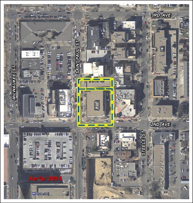
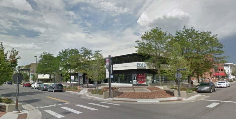
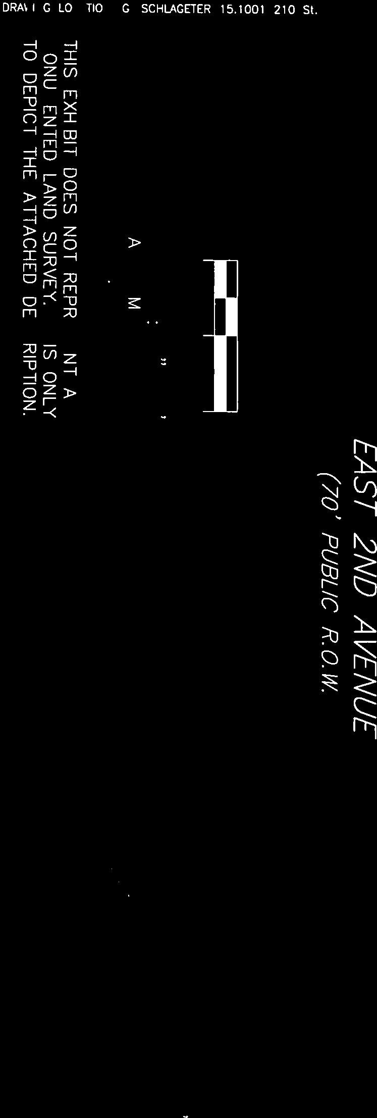
1 Community Planning and Development Planning Services 201 W. Colfax Ave., Dept. 205 Denver, CO p: f: TO: Denver City Council FROM: Theresa Lucero, Senior City Planner DATE: April 7, 2016 RE: Official Zoning Map Amendment Application #2015I St. Paul Street Rezoning from PUD-G #1 to C-CCN-7 and C-CCN-8 Staff Report and Recommendation Based on the criteria for review in the Denver Zoning Code, staff recommends approval for map amendment application #2015I for a rezoning from PUD-G #1 to C-CCN-7 and C-CCN-8 Request for Rezoning Application: 2015I Address: 210 St. Paul Street Neighborhood/Council District: Cherry Creek Neighborhood / City Council District 10 RNOs: Cherry Creek Area Business Alliance; Cherry Creek North Neighborhood Association; Cherry Creek North Business Improvement District; Harman Neighborhood Association, Inc.; Capitol Hill United Neighborhoods, Inc.; Denver Neighborhood Association, Inc.; Inter-Neighborhood Cooperation Area of Property: 25,205 SF square feet or 0.57 acres Current Zoning: PUD-G #1 Proposed Zoning: C-CCN-7 and C-CCN-8 Property Owner(s): 2 nd & St Paul, LLC and BAH-PLA, LLC Owner Representative: Phil Workman Summary of Rezoning Request The subject property is a single parcel which contains one existing commercial structure that was built in The property owner proposes to rezone the subject property to the same zone district as surrounding properties in order to redevelop the entire property for residential occupancy with ground story retail. The C-CCN-8 district is proposed for the larger southern portion of the property, and the C- CCN-7 district is proposed for the smaller norther portion of the property (see map on page 3). The proposed C-CCN-7 and C-CCN-8 (Urban Center, Cherry Creek North, with 7 and 8 story height limits) zone districts are intended for use in the Cherry Creek North mixed use shopping district with retail, restaurant, office and entertainment land uses that are in keeping with the existing character and scale of the area. The districts encourage pedestrian-oriented development through primary street setbacks, open space incentives, and building forms that allow light and views between buildings. The C-CCN-7 and 8 zone districts are focused on local, collector and arterial streets where a building scale of 1 to 7 or 8 stories is desired. Further details of the zone districts can be found in Article 7 of the Denver Zoning Code (DZC).


2 Rezoning Application #2015I St. Paul Street April 7, 2016 Page - 2 -
3 Rezoning Application #2015I St. Paul Street April 7, 2016 Page C-CCN-7 C-CCN-8 Existing Context The subject property is located in southeast Denver in the Cherry Creek Statistical Neighborhood. The property is in the central portion of the neighborhood, 1 block north of the Cherry Creek Shopping Center, 4 blocks south of 6 th Avenue, 8 blocks west of Colorado Boulevard and, 3 blocks east University Boulevard. The adjacent Cherry Creek North shopping area is comprised of a mixture of commercial land uses, zone lots of varying sizes and structures ranging in scale from 1 to 8-stories. Area parks include James N. Manley Park at 4 th & University, the Cherry Creek Greenway and Trail aligned along Cherry Creek, Pulaski and City of Karmiel Park between Bayaud and Alameda Avenues along Cherry Creek North Drive, and across Colorado Boulevard Burns and Cranmer Parks. Area schools include Bromwell Elementary School located at 3 rd and Josephine Street, Good Shepherd
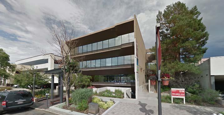
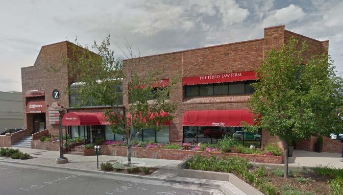
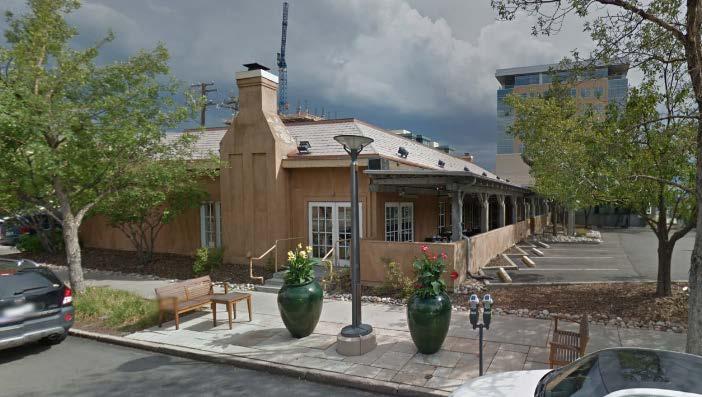
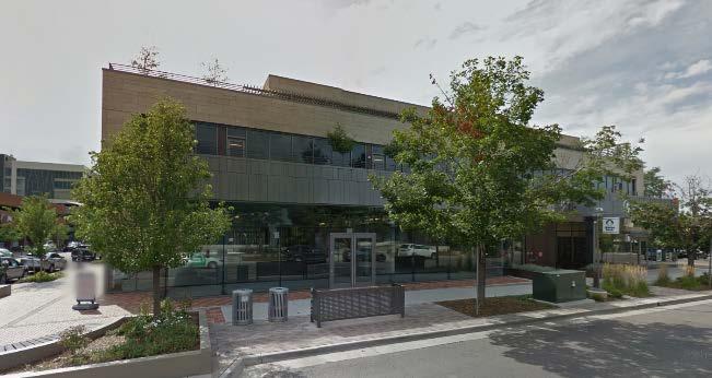
4 Rezoning Application #2015I St. Paul Street April 7, 2016 Page Catholic Church at 6 th and Elizabeth, Hill Middle School a 5 th and Clermont Street and Graland Country Day School at 1 st and Clermont Street. The physical context of the neighborhood is a traditional street grid with rectilinear blocks with alleys. Sidewalks are generally detached with landscaping embedded in the sidewalk. The following table summarizes the existing context adjacent to the subject site: Existing Zoning Existing Land Use Site PUD-G #1 Commercial North C-CCN-7 Office South C-CCN-5 Restaurant East PUD 313 Office West C-CCN-8 Office Existing Building Form/Scale 2-story commercial structure 3-4 story commercial structure 1-story commercial structure 2-story commercial structure 1-3-story mixed use structures Existing Block, Lot, Street Pattern Regular grid streets shaping a consistent pattern of rectilinear blocks with alleys; Vehicle parking is both structured and to the side or rear of buildings (alley access).
5 Rezoning Application #2015I St. Paul Street April 7, 2016 Page Existing Zoning PUD-G #1 was approved in 2011 and limits the maximum square feet of structures to 47,000 square feet and the maximum number of dwelling units to 19. The PUD also limits maximum height to 5- stories, or 55 feet.

6 Rezoning Application #2015I St. Paul Street April 7, 2016 Page Existing Land Use Map
7 Rezoning Application #2015I St. Paul Street April 7, 2016 Page Existing Building Form and Scale
8 Rezoning Application #2015I St. Paul Street April 7, 2016 Page Summary of City Agency Referral Comments As part of the DZC review process, the rezoning application is referred to potentially affected city agencies and departments for comment. A summary of agency referral responses follows: Asset Management: Approved, no comments. Public Works City Surveyor: Approved. Public Works - Wastewater: Approved see comments below. There is no objection to the rezone, however applicant should be under notice that Public Works will not approve any development of this property without assurance that there is sufficient sanitary and storm sewer capacity. A sanitary study and drainage study may be required. These studies may result in a requirement for the developer to install major infrastructure improvements or a limit to development if current infrastructure is insufficient. Approval of this rezone on behalf of Wastewater does not state, or imply, public storm/sanitary infrastructure can, or cannot, support the proposed rezoning. Parks and Recreation: Approved. Public Review Process Informational Notice CPD staff provided informational notice of receipt of the rezoning application to affected members of City Council and Registered Neighborhood Organizations on December 2, Planning Board The property was legally posted for a period of 15 days announcing the February 3, 2016, Denver Planning Board public hearing, and written notification of the hearing was sent to all affected registered neighborhood organizations and City Council members. At the meeting the Planning Board voted unanimously (8-0) to recommend that City Council approve the rezoning. Neighborhoods and Planning Committee Following Planning Board review the rezoning application will be referred to the Neighborhoods and Planning (PLAN) Committee of the City Council for review at a public meeting. The PLAN Committee meeting was scheduled for March 2, Electronic notice of the meeting will be sent to all affected Registered Neighborhood Organizations 10 days in advance of the meeting. At the meeting Committee members voted to move the application forward to a public hearing before the full City Council. City Council Following PLAN Committee review, the rezoning application is typically referred to the full City Council for final action at a public hearing. The City Council public hearing is scheduled for April 11, Electronic notice of the public hearing will be sent to all affected Registered Neighborhood Associations and notification signs will be posted on the property 21 days in advance of the hearing. Registered Neighborhood Organizations (RNOs)
9 Rezoning Application #2015I St. Paul Street April 7, 2016 Page To date, CPD has received one comment letter from the Cherry Creek North Neighborhood Association, a Registered Neighborhood Organization. The letter indicates the organization does not submit letters of support, and there is no opposition to the rezoning application. The letter is attached to this report. Other Public Comment To date, no other public comments have been received. Criteria for Review / Staff Evaluation The criteria for review of this rezoning application are found in DZC, Sections and , as follows: DZC Section Consistency with Adopted Plans 2. Uniformity of District Regulations and Restrictions 3. Public Health, Safety and General Welfare DZC Section Justifying Circumstances 2. Consistency with Neighborhood Context Description, Zone District Purpose and Intent Statements 1. Consistency with Adopted Plans The following adopted plans apply to this property: Denver Comprehensive Plan 2000 Blueprint Denver (2002) Cherry Creek Area Plan (2012) Denver Comprehensive Plan 2000 The proposal is consistent with many Denver Comprehensive Plan strategies, including: Environmental Sustainability Strategy 2-F Conserve land by promoting infill development within Denver at sites where services and infrastructure are already in place (p. 39). Land Use Strategy 3-B Encourage quality infill development that is consistent with the character of the surrounding neighborhood; that offers opportunities for increased density and more amenities; and that broadens the variety of compatible uses (p. 60). Economic Activity 4-B Enhance existing business centers and establish new business centers in a manner that offers a variety of high-quality uses that support Denver s business environment, complements neighboring residential areas, generates public revenue, and creates jobs. Maintain the Cherry Creek Shopping Center, Cherry Creek North and other nearby areas as the premier retail destination in the Denver metro area and the Rocky Mountain region (p. 135). The rezoning is consistent with these Plan recommendations. The proposed C-CCN-7 and C-CCN-8 zone districts allow a variety of residential and commercial land uses. The map amendment will enable the redevelopment for residential and retail land uses.

10 Rezoning Application #2015I St. Paul Street April 7, 2016 Page Blueprint Denver According to the 2002 Plan Map adopted in Blueprint Denver, this site has a concept land use of Pedestrian Shopping Corridor and is located in an Area of Change. Future Land Use The Blueprint Denver Pedestrian Shopping Corridor concept land use designation is described in the Plan as containing a mix of shopping, entertainment, service and employment land uses generally oriented in a linear pattern. Pedestrian shopping corridors have a continuous street frontage of buildings, wide sidewalks, on-street parking, and shared parking among businesses (p. 45). The proposed redevelopment of the existing retail land use into a mix of residential with ground floor retail is consistent with this land use concept because additional residential and commercial land uses contribute to the vitality of the Pedestrian Shopping Corridor Blueprint Denver Future Land Use Map
11 Rezoning Application #2015I St. Paul Street April 7, 2016 Page Area of Change / Area of Stability As noted, the subject property is in an Area of Change. In general, The goal for Areas of Change is to channel growth where it will be beneficial and can best improve access to jobs, housing and services with fewer and shorter auto trips...a major goal is to increase economic activity in the area to benefit existing residents and businesses, and where necessary, provide a stimulus to redevelop (p. 127). For the Cherry Creek Area of Change Blueprint Denver states The neighborhood vision is to continue redeveloping the area in a manner that focuses on livability and produces a wellintegrated blend of residential, regional and neighborhood retail, office, hotel, open space, and public uses in a pedestrian-friendly environment (p. 134). The rezoning application is consistent with the Blueprint Denver Area of Change recommendation of channeling growth where it can improve access to housing and services with fewer and shorter auto trips. Expanding and redeveloping residential and commercial land uses in close proximity to the shopping and services of the Cherry Creek Shopping Center and Cherry Creek North Shopping Area make this proposal consistent with the goals of Areas of Change. Street Classifications Blueprint Denver classifies St. Paul Street as an Undesignated Local street and 2 nd Avenue as a Mixed Use Collector. According to Blueprint Denver, local streets are tailored more to providing local access and collectors are designed to provide a greater balance between mobility and land access within residential, commercial and industrial areas. The C-CCN-7 and C-CCN-8 zone districts allow the higher-intensity mixture of uses envisioned for areas served by collector streets in a Pedestrian Shopping Corridor/Area of Change. Small Area Plan: Cherry Creek Area Plan (2012) The Cherry Creek Area Plan offers guidance for both the overall neighborhood, in the Framework Plan, and for subareas within the neighborhood. The Framework Plan discusses the mixed use character of the Cherry Creek Neighborhood. Part of the character of Cherry Creek is its mixture of land uses. Retail and service uses appealing to both local and regional shoppers, office and established residential neighborhoods weave an interdependent mixed-use urban environment resulting in a variety of amenities benefiting the quality of life. [ ] Continued introduction of office space, retail, and residential units will enhance the mixed-use nature of the neighborhood and reinforce the plan vision. As in most mixed-use districts throughout the country, the desire to maintain the character of Cherry Creek must be balanced with the thoughtful redevelopment of underutilized properties (pg ). Framework Plan The Framework Plan recommends that growth be targeted appropriately and economic activity be concentrated. The Plan updated the Blueprint Denver Map of Areas of Change and offers this guidance for Areas of Change: The Areas of Change in Cherry Creek have the greatest potential to accommodate this growth, both in terms of market demand and available land. Although not every property will see significant redevelopment, overall these areas benefit from new development, reinvestment, and more intense use. Areas of Change include the Shopping District, Cherry Creek Triangle, 1st Avenue, the commercial node at Madison and Bayaud and Harrison Street south of 1st Avenue (pg. 29). And further, the Plan provides these recommendations for targeting growth in these Cherry Creek Areas of Change:
.")
12 Rezoning Application #2015I St. Paul Street April 7, 2016 Page Acknowledge that to remain prosperous, Cherry Creek must continue to grow and change. In order for this growth to occur in a way that reinforces the quality of life for Cherry Creek residents, the bulk of this growth should occur in these areas rather than stable neighborhoods (p. 29). Update the Blueprint Denver map to reflect revised Areas of Change boundaries. The updated Areas of Change are targeted to receive most of Cherry Creek s residential and commercial growth over the next twenty years (p. 29). Modify land use policy, zoning regulations and design guidelines to encourage appropriate reinvestment to assure that Areas of Change continue to mature in positive ways (p. 29). The subject property is circled on the updated Cherry Creek Areas of Change map below. Further, to concentrate economic activity, the Plan recommends encouraging moderate scale development in mixed use areas of change. Areas of Change which are not adjacent to higher intensity locational criteria [multi-modal streets, major intersections and major public open spaces] are appropriate for mid-rise buildings to accommodate continued growth. General locations include the Shopping District and 1 st Avenue (east of Steele), and some existing mixed-use areas within Cherry Creek North Residential and Cherry Creek East. Plan recommendation include: Encourage mid-rise buildings to promote reinvestment and to help transition development intensity and buffer stable residential areas from higher intensity locations (p. 32). Further the Plan recommends the continued evolution of the mixed use areas. The Cherry Creek Shopping District has evolved into an 18-hour, mixed-use neighborhood consisting of retail, commercial and residential land uses. Continued development in the district has resulted in the introduction of residential units in the district, encouraging expanded options and diversity of residents (p. 34).

13 Rezoning Application #2015I St. Paul Street April 7, 2016 Page Finally, the Framework Plan recommends a prosperous Cherry Creek and continued reinvestment. The Cherry Creek area has thrived with its diverse mix of uses. From its origins as a residential neighborhood, shopping district and mall, expanded uses have included office, hotels and higher density residential. The area has proven to be very attractive to all of these development types, so Plan recommendations focus on enhancing amenities and removing public policy impediments. [ ] Residential uses contribute significantly to the vitality of the area. While Cherry Creek North and East continue to experience infill development, the greatest potential for new residential is as part of mixeduse development in the Shopping District and on vacant parcels in the Cherry Creek Triangle. All of this housing will continue to reinforce the range of housing types already found in the Cherry Creek Area single family, duplexes, row houses, and condo and apartment towers (p. 46). The proposed C-CCN-7 and C-CCN-8 zone districts implement the Cherry Creek Area Plan concept of reinvestment and moderately scaled development in a location that the Plan has designated an Area of Change. Cherry Creek Subareas The Cherry Creek Area Plan also contains recommendations for subareas defined by the Plan. Subarea recommendations are used in the Plan to supplement the more general Framework Plan recommendations. The subject property is located in the Cherry Creek Shopping District subarea (see the circled area on the subarea map). The subarea is described by the Plan as the region s most vibrant upscale retail and mixed-use district. Within the Shopping District subarea the subject property is designated a Regional Center. For this portion of the Cherry Creek Shopping District subarea the Plan recommends: Regional Center and Town Center. Continue to support a mix of uses including office, retail, commercial and multifamily residential. Support compact development patterns and an enhanced public realm including landscaping, wayfinding signage, pedestrian lighting, public art and inviting building entries. The Town Center areas act as an important transition between Regional Center and residential areas in scale and/or use (p. 58). Scale. Maximum building heights in the Shopping District should range from 4 to 12 stories per the Maximum Building Heights Map. Building heights should be lower adjacent to residential areas in Cherry Creek North and Country Club neighborhoods. Higher development intensity is encouraged along multi-modal streets and key intersections. Mid-rise buildings (maximum of 5 to 8 stories) are recommended as transitions between high intensity and low intensity residential neighborhoods (p. 58). CCN Business Improvement District. Enact zoning and other land use regulatory tools for the C-CCN zone district [New CCN zone districts adopted in 2014] to encourage rather than inhibit high quality redevelopment and reinvestment across all parcel sizes, large and small. Retain the positive elements of current zoning including ground floor retail, design review, quality design and arterials, interesting signage, and parking location. Reconsider height, FAR, building form and parking requirements. Engage in an open, transparent and efficient public process that includes

14 Rezoning Application #2015I St. Paul Street April 7, 2016 Page all stakeholders interests and includes the following goals created by the CCN Urban Form Working Group, 2012: o Retain and enhance Cherry Creek s North unique physical character. o Make economic redevelopment economically viable in the entire district. o Transition from higher buildings along 2 nd to lower buildings along 3 rd. o Create height transitions from the business district to adjacent residential (p. 61). The proposed 7 and 8-story heights conform to the maximum building height recommended in the Cherry Creek Area Plan and provides an appropriate height transition within the Regional Center between 2 nd and 3 rd Avenues. See the Future Land Use Map and the Maximum Building Heights Map below. 2. Uniformity of District Regulations and Restrictions The proposed rezoning to C-CCN-7 and C-CCN-8 zone districts will result in the uniform application of zone district building form, use and design regulations.
15 Rezoning Application #2015I St. Paul Street April 7, 2016 Page Public Health, Safety and General Welfare The proposed official map amendment furthers the public health, safety, and general welfare of the City by implementing the City s adopted plans for the area. 4. Justifying Circumstance The application identifies changed or changing conditions as the Justifying Circumstance under DZC Section A.4, The land or its surrounding environs has changed or is changing to such a degree that it is in the public interest to encourage a redevelopment of the area or to recognize the changed character of the area. As the Cherry Creek Area Plan discusses above, Cherry Creek must continue to grow and change to remain prosperous and to reinforce the quality of life for neighborhood residents. The subject property is located within an area the Cherry Creek Area Plan designates as a Regional Center and an Area of Change, where reinvestment and growth should be directed, and where the character of the area is expected to change, and is indeed changing. The proposed rezoning will acknowledge the changing character of the area and will accommodate the planned reinvestment in the area, and this is an appropriate justifying circumstance for the proposed rezoning. 5. Consistency with Neighborhood Context Description, Zone District Purpose and Intent Statements The requested C-CCN-7 and C-CCN-8 zone districts are within the Urban Center Neighborhood Context. The Urban Center Context is characterized by multi-unit residential and mixed use commercial strips and centers in a variety of building forms. Multi-unit residential uses are primarily located along residential collector, mixed-use arterial and local streets. Commercial uses are primarily located along main and mixed-use arterials. The block and street pattern consists of regular block shapes formed by a grid street system. In this context building heights are moderate to high to promote a dense urban character. A high level of connectivity to multi-modal transit is characteristic of the context. The C-CCN-7 and C-CCN-8 zone districts are intended to promote safe, active, and pedestrian-scaled diverse areas with a variety of residential and commercial building forms located on collector or arterial streets. The proposed rezoning of the subject property to C-CCN-7 and C-CCN-8 zone districts is consistent with the Urban Center Context and the specific intent of the C-CCN-7 and C- CCN-8 zone districts. Staff Recommendation Based on the analysis set forth above, CPD staff finds that the application for rezoning the property located at 210 St. Paul Street to C-CCN-7 and C-CCN-8 zone districts meet the requisite review criteria. Accordingly, staff recommends approval. Attachments 1. Application 2. Approved Legal Description 3. Cherry Creek North Neighborhood Association Letter

16 2015I November 30th, 2015 $1000 pd chk#

17 2015I November 30th, 2015 $1000 pd chk#

18 2015I November 30th, 2015 $1000 pd chk#
19 2015I November 30th, 2015 $1000 pd chk#
20 2015I November 30th, 2015 $1000 pd chk#
21 2015I November 30th, 2015 $1000 pd chk#
22 2015I November 30th, 2015 $1000 pd chk#
23 2015I November 30th, 2015 $1000 pd chk#
24 2015I November 30th, 2015 $1000 pd chk#
25 2015I November 30th, 2015 $1000 pd chk#
26 2015I November 30th, 2015 $1000 pd chk#
27 2015I November 30th, 2015 $1000 pd chk#
28 2015I November 30th, 2015 $1000 pd chk#
29 2015I November 30th, 2015 $1000 pd chk#
30 2015I November 30th, 2015 $1000 pd chk#


31


32

33

34
35 January 28, 2016 Ms. Julie Underdahl, Chair Denver Planning Board 201 W Colfax, Dept. 205 Denver, CO RE: St. Paul Dear Ms. Underdahl and the Planning Board The above referenced application is within the boundaries of Cherry Creek North. The applicant, Matt Joblon, presented to the Cherry Creek North Neighborhood Association Residents meeting on October 12, 2015 and again on November 12, 2015 to the Cherry Creek North Board of Directors. In his presentation, Mr. Joblon committed to the inclusion of heated sidewalks on the retail level of the project. He also indicated that, while no elevations were available for viewing at that time, he would continue to keep the neighborhood informed as the project specifics and elevations became available. The policy of the Board of Directors is to not submit letters of support. However, as a result of the applicants' presentation to both the CCNNA members and the board, and based on his representations to the Board, there was no opposition to this application for rezoning from PUD to CCN 8/7. Sincerely, Robert A. Vogel, MD President, CCNNA
Staff Report and Recommendation
 Community Planning and Development Planning Services 201 W. Colfax Ave., Dept. 205 Denver, CO 80202 p: 720.865.2915 f: 720.865.3052 www.denvergov.org/cpd TO: City Council Neighborhoods and Planning Committee
Staff Report and Recommendation Based on the criteria for review in the Denver Zoning Code, Staff recommends approval for Application #2017I
 TO: Denver City Council Land Use, Transportation and Infrastructure Committee FROM: Theresa Lucero, Senior City Planner DATE: RE: Official Zoning Map Amendment Application #2017I-00149 Staff Report and
Planning Services Community Planning and Development 201 W. Colfax Ave., Dept. 205 Denver, CO p
 TO: Denver Planning Board, Julie Underdahl, Chair FROM: Theresa Lucero, Senior City Planner DATE: RE: Official Zoning Map Amendment Application #2017I-00042 Staff Report and Recommendation Based on the
, C-MS I June 3, 2016 $1500 pd chk #216918
 , C-MS-8 LOTS 21 THROUGH 40, INCLUSIVE, BLOCK 299 CLEMENTS ADDITION TO THE CITY OF DENVER SOUTHEAST QUARTER OF SECTION 34, TOWNSHIP 3 SOUTH, RANGE 68 WEST, SIXTH PRINCIPAL MERIDIAN, CITY
TO: Denver Planning Board FROM: Analiese Hock, Senior City Planner DATE: March 13, 2018 RE:
 Community Planning and Development Planning Services 201 W. Colfax Ave., Dept. 205 Denver, CO 80202 p: 720.865.2915 f: 720.865.3052 www.denvergov.org/cpd TO: Denver Planning Board FROM: Analiese Hock,
Official Zoning Map Amendment Application #2018I-00047
 Community Planning and Development Planning Services 201 W. Colfax Ave., Dept. 205 Denver, CO 80202 p: 720.865.2915 f: 720.865.3052 www.denvergov.org/cpd TO: Denver Planning Board FROM: Chandler Van Schaack,
Staff Report and Recommendation Based on the criteria for review in the Denver Zoning Code, Staff recommends approval for Application #2018I
 Community Planning and Development Planning Services 201 W. Colfax Ave., Dept. 205 Denver, CO 80202 p: 720.865.2915 f: 720.865.3052 www.denvergov.org/cpd TO: Denver Planning Board FROM: Sara White, AICP,
REZONING GUIDE. Zone Map Amendment (Rezoning) - Application. Rezoning Application Page 1 of 3. Return completed form to
 - Application. Rezoning Application Page 1 of 3. Return completed form to") Zone Map Amendment (Rezoning) - Application COMMUNITY PLANNING & DEVELOPMENT REZONING GUIDE Rezoning Application Page 1 of 3 PROPERTY OWNER INFORMATION* CHECK IF POINT OF CONTACT FOR APPLICATION Property
Zone Map Amendment (Rezoning) - Application COMMUNITY PLANNING & DEVELOPMENT REZONING GUIDE Rezoning Application Page 1 of 3 PROPERTY OWNER INFORMATION* CHECK IF POINT OF CONTACT FOR APPLICATION Property
Official Zoning Map Amendment Application #2018I-00077
 Community Planning and Development Planning Services 201 W. Colfax Ave., Dept. 205 Denver, CO 80202 p: 720.865.2915 f: 720.865.3052 www.denvergov.org/cpd TO: Denver Planning Board FROM: Scott Robinson,
Staff Report and Recommendation
 Community Planning and Development Planning Services 201 W Colfax Ave, Dept 205 Denver, CO 80202 p: 720-865-2972 f: 720-865-3056 www.denvergov.org/planning TO: LUTI FROM: Steve Nalley, Senior City Planner
September 25th, 2018 $2000 fee pd CC
 2.7267 acres 2018I-00075 September 25th, 2018 $2000 fee pd CC Rezoning Review Criteria Analysis - Map Amendment Application Number: 2018I-00075 805 W. 38 th Avenue October 19, 2018 (amd.) September 17,
Denver Land Use, Transportation and Infrastructure Committee FROM: Andrew Webb, Senior City Planner DATE: March 22, 2018 RE:
 Community Planning and Development Planning Services 201 W. Colfax Ave., Dept. 205 Denver, CO 80202 p: 720.865.2915 f: 720.865.3052 www.denvergov.org/cpd TO: Denver Land Use, Transportation and Infrastructure
#2017I E-RH-2.5 Highland Ventures Holdings, LLC and Irving Estates, LLC
 TO: Denver Planning Board - Joel Noble, Chair FROM: Theresa Lucero, Senior City Planner DATE: RE: Official Zoning Map Amendment Application #2017I-00178 1080 and 1090 King Street Rezoning from E-SU-D1x
TO: Staff Report and Recommendation
 Community Planning and Development Planning Services 201 W. Colfax Ave., Dept. 205 Denver, CO 80202 p: 720.865.2915 f: 720.865.3052 www.denvergov.org/cpd TO: City Council Neighborhoods and Planning Committee
DENVER DESIGN DISTRICT GDP
 DENVER DESIGN DISTRICT GDP Urban Design Standards and Guidelines November 17, 2008 Amended February 3, 2016 City and County of Denver CF Property Management, Inc. C/O Denver Design District - Starboard
To: S-MX-8 AIO, S-MX-8A AIO, S-MX-12 AIO, C-MX-8 AIO, C-MX-12 AIO, and S-CC-5 AIO
 Community Planning and Development Planning Services 201 W. Colfax Ave., Dept. 205 Denver, CO 80202 p: 720.865.2915 f: 720.865.3052 www.denvergov.org/cpd TO: City Council Neighborhoods and Planning Committee
REZONING GUIDE. Zone Map Amendment (Rezoning) - Application. Rezoning Application Page 1 of 3. Return completed form to
 - Application. Rezoning Application Page 1 of 3. Return completed form to") Zone Map Amendment (Rezoning) - Application COMMUNITY PLANNING & DEVELOPMENT REZONING GUIDE Rezoning Application Page 1 of 3 PROPERTY OWNER INFORMATION* CHECK IF POINT OF CONTACT FOR APPLICATION Property
Zone Map Amendment (Rezoning) - Application COMMUNITY PLANNING & DEVELOPMENT REZONING GUIDE Rezoning Application Page 1 of 3 PROPERTY OWNER INFORMATION* CHECK IF POINT OF CONTACT FOR APPLICATION Property
Official Zoning Map Amendment Application #2018I-00075
 Community Planning and Development Planning Services 201 W. Colfax Ave., Dept. 205 Denver, CO 80202 p: 720.865.2915 f: 720.865.3052 www.denvergov.org/cpd TO: Denver Planning Board FROM: Scott Robinson,
CITY OF PUYALLUP. Background. Development Services
 CITY OF PUYALLUP Development Services 333 South Meridian Puyallup WA 98371 To: City Council From: Katie Baker, AICP, Planning Division Re: South Hill Neighborhood Plan Adoption Date: (Meeting date: February
Land Use Amendment in Southwood (Ward 11) at and Elbow Drive SW, LOC
 at and Elbow Drive SW, LOC") 2018 November 15 Page 1 of 10 EXECUTIVE SUMMARY This land use amendment application was submitted by Rick Balbi Architect on 2017 August 31 on behalf of Sable Developments Ltd, and with authorization from
2018 November 15 Page 1 of 10 EXECUTIVE SUMMARY This land use amendment application was submitted by Rick Balbi Architect on 2017 August 31 on behalf of Sable Developments Ltd, and with authorization from
ARLINGTON COUNTY, VIRGINIA
 ARLINGTON COUNTY, VIRGINIA County Board Agenda Item Meeting October 15, 2005 DATE: September 28, 2005 SUBJECT: Request to Advertise the adoption of the 2005 Clarendon Sector Plan C. M. RECOMMENDATION:
Tyvola & Archdale Transit Station Area Plan. May 15, 2008
 Tyvola & Archdale Transit Station Area Plan First Public Meeting May 15, 2008 Presentation Outline 1. Purpose and Process 2. Station Area Overview 3. Plan Recommendations Vision Land Use Transportation
AWH REPORT OF THE PLANNING AND DEVELOPMENT DEPARTMENT FOR APPLICATION FOR REZONING ORDINANCE TO PLANNED UNIT DEVELOPMENT
 AWH REPORT OF THE PLANNING AND DEVELOPMENT DEPARTMENT FOR APPLICATION FOR REZONING ORDINANCE TO PLANNED UNIT DEVELOPMENT MAY 8, 2014 The Planning and Development Department hereby forwards to the Planning
C. Westerly Creek Village & The Montview Corridor
 C. Westerly Creek Village & The VISION Community Vision When the goals of the city are achieved Westerly Creek Village, a distinctive community defined by Montview Boulevard and Westerly Creek, is a strong
YONGE STEELES CORRIDOR SECONDARY PLAN. Young + Wright / IBI Group Architects Dillon Consulting Ltd. GHK International (Canada) Ltd.
 Ltd.") PART A: PREAMBLE 1.0 PURPOSE The purpose of this Secondary Plan is to provide a development framework for intensification of the Yonge/ Steeles corridor including the north side of Steeles Avenue West
PART A: PREAMBLE 1.0 PURPOSE The purpose of this Secondary Plan is to provide a development framework for intensification of the Yonge/ Steeles corridor including the north side of Steeles Avenue West
Urban Design Manual PLANNING AROUND RAPID TRANSIT STATIONS (PARTS) Introduction. Station Study Areas
 Introduction. Station Study Areas") 111111 PLANNING AROUND RAPID TRANSIT STATIONS (PARTS) Introduction The ION rapid transit system will link Waterloo, Kitchener and Cambridge through a central transit corridor (CTC). There are a number
111111 PLANNING AROUND RAPID TRANSIT STATIONS (PARTS) Introduction The ION rapid transit system will link Waterloo, Kitchener and Cambridge through a central transit corridor (CTC). There are a number
Staff Report and Recommendation
 Community Planning and Development Planning Services 201 W. Colfax Ave., Dept. 205 Denver, CO 80202 p: 720.865.2915 f: 720.865.3052 www.denvergov.org/cpd TO: Denver City Council FROM: Steve Nalley, Neighborhood
Steering Committee Meeting
 Neighborhood Planning Initiative NPI EAST CENTRAL AREA PLAN Steering Committee Meeting November 9, 2017 6:00PM 8:00PM Tears McFarlane House East Central Area Plan Steering Committee Meeting 11/9/17 AGENDA
Urban Planning and Land Use
 Urban Planning and Land Use 701 North 7 th Street, Room 423 Phone: (913) 573-5750 Kansas City, Kansas 66101 Fax: (913) 573-5796 Email: planninginfo@wycokck.org www.wycokck.org/planning To: From: City Planning
BUILDING SCALE AND SETBACKS 5 ELEMENTS:... 5 FAÇADES (COMMERCIAL/RESIDENTIAL) 5
 5") VISION STATEMENT 3 UTILIZATION OF THE GUIDELINES 3 IMPLEMENTATION 3 PROCEDURES FOR DESIGN REVIEW 3 LAND USE AND ZONING 4 LAND USE 4 ELEMENTS:... 4 ZONING 4 ELEMENTS:... 4 BUILDING SCALE AND SETBACKS 5
VISION STATEMENT 3 UTILIZATION OF THE GUIDELINES 3 IMPLEMENTATION 3 PROCEDURES FOR DESIGN REVIEW 3 LAND USE AND ZONING 4 LAND USE 4 ELEMENTS:... 4 ZONING 4 ELEMENTS:... 4 BUILDING SCALE AND SETBACKS 5
Town Center (part of the Comprehensive Plan)
") Town Center (part of the Comprehensive Plan) Mercer Island Town Center Looking North (2014) In 1994, a year-long process culminated in a set of design guidelines and code requirements for the Town Center
Town Center (part of the Comprehensive Plan) Mercer Island Town Center Looking North (2014) In 1994, a year-long process culminated in a set of design guidelines and code requirements for the Town Center
ROAD CLOSURE AND LAND USE AMENDMENT SILVER SPRINGS (WARD 1) NORTHEAST OF NOSEHILL DRIVE NW AND SILVER SPRINGS ROAD NW BYLAWS 2C2018 AND 29D2018
 NORTHEAST OF NOSEHILL DRIVE NW AND SILVER SPRINGS ROAD NW BYLAWS 2C2018 AND 29D2018") Page 1 of 19 EXECUTIVE SUMMARY This application proposes redesignating two parcels in the community of Silver Springs from Special Purpose Future Urban Development (S-FUD) District and undesignated road
Page 1 of 19 EXECUTIVE SUMMARY This application proposes redesignating two parcels in the community of Silver Springs from Special Purpose Future Urban Development (S-FUD) District and undesignated road
CPD Rules and Regulations. Arapahoe Square Zoning and Design Standards/Guidelines
 CPD Rules and Regulations Arapahoe Square Zoning and Design Standards/Guidelines Denver Planning Board May 4 th, 2016 Sponsor & Community Partners Sponsored by Albus Brooks, Council District 9 Developed
East Central Area Plan
 East Central Area Plan Steering Committee Meeting March 8 th, 2018 CHUN Tears McFarlane House Vision Statement Development Opportunities Analysis Vision Elements 1. Equitable, Affordable and Inclusive
Citizen Comment Staff Response Staff Recommended Revision Planning Committee
 Citizen Comment Staff Response Staff Recommended Revision Planning Committee Area No. 1: Owner desires retail land uses. Area No. 1a: Owner of two small parcels adjacent to Area No. 1 desires retail land
5 TOWN OF MARKHAM OFFICIAL PLAN AMENDMENT NO. 144 MILLIKEN MAIN STREET SECONDARY PLAN
 5 TOWN OF MARKHAM OFFICIAL PLAN AMENDMENT NO. 144 MILLIKEN MAIN STREET SECONDARY PLAN The Planning and Economic Development Committee recommends the following: 1. The communication from Brendan O Callaghan,
[PLANNING RATIONALE] For Site Plan Control and Lifting of Holding Zone By-Law 101 Champagne Avenue. May 23, 2014
![[PLANNING RATIONALE] For Site Plan Control and Lifting of Holding Zone By-Law 101 Champagne Avenue. May 23, 2014](/thumbs/75/71599615.jpg "[PLANNING RATIONALE] For Site Plan Control and Lifting of Holding Zone By-Law 101 Champagne Avenue. May 23, 2014") [PLANNING RATIONALE] For Site Plan Control and Lifting of Holding Zone By-Law 101 Champagne Avenue May 23, 2014 Contents 1.0 Introduction... 2 2.0 Site Context... 2 2.1 Adjacent Uses... 2 Figure 1: Site
[PLANNING RATIONALE] For Site Plan Control and Lifting of Holding Zone By-Law 101 Champagne Avenue May 23, 2014 Contents 1.0 Introduction... 2 2.0 Site Context... 2 2.1 Adjacent Uses... 2 Figure 1: Site
REQUEST Current Zoning: O-15(CD) (office) Proposed Zoning: TOD-M(CD) (transit oriented development mixed-use, conditional)
 (office) Proposed Zoning: TOD-M(CD) (transit oriented development mixed-use, conditional)") Rezoning Petition 2016-117 Zoning Committee Recommendation January 4, 2017 REQUEST Current Zoning: O-15(CD) (office) Proposed Zoning: TOD-M(CD) (transit oriented development mixed-use, conditional) LOCATION
Rezoning Petition 2016-117 Zoning Committee Recommendation January 4, 2017 REQUEST Current Zoning: O-15(CD) (office) Proposed Zoning: TOD-M(CD) (transit oriented development mixed-use, conditional) LOCATION
EXISTING COMPREHENSIVE PLAN
 EXISTING COMPREHENSIVE PLAN Town Center Land Use Element: V. LAND USE POLICIES Town Center Mercer Island's business district vision as described in "Your Mercer Island Citizen-Designed Downtown" was an
CONTENTS 8.0 LAND USE 8.1 GENERAL LAND USE 8.2 RESIDENTIAL 8.3 MIXED USE 8.4 COMMERCIAL 8.5 EMPLOYMENT LANDS
 8-2 Land Use 8.0 LAND USE CONTENTS 8.1 GENERAL LAND USE 8.1.1 Uses provided for in all Land Use Designations 8.1.2 Uses prohibited in Hazardous Lands, Hazardous Sites and Special Policy Areas 8.1.3 Uses
Official Plan Review: Draft Built Form Policies
 PG.30.1 REPORT FOR ACTION Official Plan Review: Draft Built Form Policies Date: May 15, 2018 To: Planning and Growth Management Committee From: Chief Planner and Executive Director, City Planning Division
SECTION ONE: INTRODUCTION. introduction
 introduction 1 INTRODUCTION Since it was first established in 1843 as a trading post for the Hudson s Bay Company, Victoria has evolved into a Provincial capital city that is recognized across Canada and
ARTICLE 6: Special and Planned Development Districts
 ARTICLE 6: Special and Planned Development Districts 6-10 Traditional Neighborhood Development (TND) District 6-10.10 Purpose and Intent The Traditional Neighborhood Development (TND) District provides
2136 & 2148 Trafalgar Road Town of Oakville Region of Halton
 PLANNING JUSTIFICATION REPORT 2136 & 2148 Trafalgar Road Town of Oakville Region of Halton Zoning By-Law Amendment Application 2500674 Ontario Inc. November 2016 Table of Contents Page 1.0 Location/Summary
A. WHAT IS A GENERAL PLAN?
 I. Introduction A. WHAT IS A GENERAL PLAN? A general plan is the planning guideline for the future of a city. It contains goals and policies which regulate urban development, the protection of the natural
Midtown Greenway Land Use and Development Plan Executive Summary
 Midtown Greenway Land Use and Development Plan Executive Summary Introduction The Midtown Greenway Land Use and Development Plan sets policy direction for land use and development in the Midtown Greenway
Prosperity Hucks Area Plan. Transportation and Planning Committee May 11, 2015
 Prosperity Hucks Area Plan Transportation and Planning Committee May 11, 2015 Presentation Outline 1. Background and Location 2. Community Dialog Process 3. Activity Center Recommendations 4. Wedge Recommendations
A. Background Summary of Existing Challenges and Potential Possibilities. 1. Summary of Existing Assets and Potential Opportunities
 A. Background 1 A Main Street Master Plan Study was performed and completed in October of 2007. The study was initiated to review current land uses and development patterns along Main Street, from Parrish
North Fair Oaks Community Plan Summary and Information
 North Fair Oaks Community Plan Summary and Information WHAT IS THE NORTH FAIR OAKS COMMUNITY PLAN? The North Fair Oaks Community Plan is part of the San Mateo County General Plan, and establishes policies
Rapid City Planning Commission Rezoning Project Report
 Rapid City Planning Commission Rezoning Project Report July 21, 2016 Applicant Request(s) Case # 16RZ022 Rezoning from Office Commercial District to Light Industrial District Companion Case(s): 16RZ023-Rezoning
CONSENT CALENDAR CITY PLANNING COMMISSION AGENDA ITEM NO: A.1, A.2 STAFF: LARRY LARSEN
 Page 8 CONSENT CALENDAR CITY PLANNING COMMISSION AGENDA ITEM NO: A.1, A.2 STAFF: LARRY LARSEN FILE NO: CPC PUZ 14-00013 - QUASI-JUDICIAL FILE NO: CPC PUD 14-00014 QUASI-JUDICIAL PROJECT: APPLICANT: OWNER:
Edward R. Sajecki Commissioner of Planning and Building
 Corporate Report Clerk s Files Originator s Files CD.03.POR DATE: TO: FROM: SUBJECT: Chair and Members of Planning and Development Committee Meeting Date: February 27, 2012 Edward R. Sajecki Commissioner
4. Shape Transitions. 4. Shape Transitions
 4. Shape Transitions 49 Zoning District Policies Overall Intent: Maintain neighborhood character by creating compatible transitions that minimize land use conflicts. Strategy: Define the character of zoning
Welcome to the Oakridge Centre Open House
 Welcome to the Oakridge Centre Open House Why is the City hosting this event? This open house is to inform you of a rezoning application submitted to the City of Vancouver to amend the existing CD-1 (Comprehensive
Planning & Zoning Commission Staff Report
 Planning & Zoning Commission Staff Report Meeting Date: May 26, 2015 Drafted by: Katherine Harrison-Rogers CASE # Z2886 PROJECT NAME: APPLICANT/ REPRESENTATIVE: Shawna Runyan PROPERTY OWNER: 1840 (previously
#2017I E-RH-2.5 Highland Ventures Holdings, LLC and Irving Estates, LLC
 TO: Denver City Council Land Use, Transportation, and Infrastructure Committee FROM: Theresa Lucero, Senior City Planner DATE: January 3, 2019 RE: Official Zoning Map Amendment Application #2017I-00178
NEW CASTLE COUNTY S ZONING DISTRICTS
 NEW CASTLE COUNTY S ZONING DISTRICTS This is general information about New Castle County s zoning districts. The information included is by no means exhaustive or complete. Before designing plans to develop
Rapid City Planning Commission Comprehensive Plan Amendment Project Report
 Rapid City Planning Commission Comprehensive Plan Amendment Project Report June 7, 2018 Applicant Request(s) Item #3 Case # 18CA001 Comprehensive Plan Amendment to change the future land use from Mixed-
LAND USE AMENDMENT CORNERSTONE (WARD 3) 60 STREET NE AND COUNTRY HILLS BOULEVARD NE MAP 26NE BYLAW 22D2017
 60 STREET NE AND COUNTRY HILLS BOULEVARD NE MAP 26NE BYLAW 22D2017") Page 1 of 14 EXECUTIVE SUMMARY This Land Use Amendment application covers an area of 43.76 hectares ± (108.14 acres ±) located in northeast Calgary, bound by Country Hills Boulevard NE to the south and
Page 1 of 14 EXECUTIVE SUMMARY This Land Use Amendment application covers an area of 43.76 hectares ± (108.14 acres ±) located in northeast Calgary, bound by Country Hills Boulevard NE to the south and
General Location Annex, Rezone & Preliminary Plat Lansdowne Addition, Unit Three
 NEWFOUNDLAND I-5 Agricultural District Subject Site SUNDANCE ANDERSON Single Family Residential CHRISTY PUD Agricultural District Highway Business General Location Annex, Rezone & Preliminary Plat Lansdowne
ELMVALE ACRES SHOPPING CENTRE MASTER PLAN
 ELMVALE ACRES SHOPPING CENTRE MASTER PLAN Contents 1.0 INTRODUCTION... 2 2.0 LOCATION... 2 3.0 EXISTING CONTEXT... 2 4.0 VISION & GUIDING PRINCIPLES... 2 5.0 LAND USE AND BUILT FORM... 4 5.1 St. Laurent
Trafalgar Road Corridor Planning Study Open House
 Trafalgar Road Corridor Planning Study Open House June 24, 2013 6:30-8:30 p.m. Oakville & Trafalgar Rooms Overview The Livable Oakville Plan identifies the lands along Trafalgar Road, between the QEW and
LEED-ND 101: Practical Strategies for Achieving Sustainability Goals. Travis Parker Lakewood Planning Director
 LEED-ND 101: Practical Strategies for Achieving Sustainability Goals Travis Parker Lakewood Planning Director Metro Vision Idea Exchange Oct 11, 2012 West Corridor Stations West Corridor Overview West
Tyvola & Archdale Transit Station Area Plan. June 5, 2008
 Tyvola & Archdale Transit Station Area Plan Second Public Meeting June 5, 2008 Presentation Outline 1. Purpose and Process 2. Station Area Overview 3. Plan Recommendations 4. Comments Received and Proposed
FUTURE LAND USE ELEMENT
 FUTURE LAND USE ELEMENT GOAL I: To create and sustain a great place to live, play, and prosper Objective 1: The City of Ocala shall incorporate the principles and strategies of the Ocala 2035 Vision into
EXECUTIVE SUMMARY DRAFT CHAPTER 1 INTRODUCTION EXECUTIVE SUMMARY
 CHAPTER 1 EXECUTIVE SUMMARY INTRODUCTION Through the joint efforts of the City of Tulsa planning staff and the Land Services division of Indian Nations Council of Governments (INCOG), the Berryhill Land
WHEREAS, after consideration of the evidence presented at the public hearing on January 14, 2010, the Prince George's County Planning Board finds:
 R E S O L U T I O N WHEREAS, the Prince George s County Planning Board has reviewed DDS-600 requesting a departure for the location of two loading spaces without driveway access along Toledo Terrace in
Lehigh Acres Land Development Regulations Community Planning Project
 Lehigh Acres Land Development Regulations Planning Effort Summary In July, 2010 Commissioner Frank Mann invited the Lehigh Acres community to start discussing how to achieve their recently adopted community
SUBJECT: GO Station Mobility Hubs Preferred Concepts: Aldershot GO, Burlington GO and Appleby GO. Planning and Development Committee - Public Meeting
 Page 1 of Report PB-76-17 SUBJECT: GO Station Mobility Hubs Preferred Concepts: Aldershot GO, Burlington GO and Appleby GO TO: FROM: Planning and Development Committee - Public Meeting Planning and Building
New Partners for Smart Growth Conference February 5, 2010
 Dan Stroh, Planning Director City of Bellevue Planning and Community Development Bellevue, WA New Partners for Smart Growth Conference February 5, 2010 Summary of Project Long-range plan update for Bel-Red
PLANNING COMMISSION REPORT
 PLANNING COMMISSION REPORT REZONING CASE NO. RZ-14-002 REPORT DATE: February 10, 2015 CASE NAME: 9990 W. Alameda Ave. Rezoning PLANNING COMMISSION DATE: February 18, 2015 ADDRESS OF REZONING PROPOSAL:
POLICY AMENDMENT AND LAND USE AMENDMENT KILLARNEY/GLENGARRY (WARD 8) NW CORNER OF RICHMOND ROAD AND 33 STREET SW BYLAWS 1P2015 AND 7D2015
 NW CORNER OF RICHMOND ROAD AND 33 STREET SW BYLAWS 1P2015 AND 7D2015") Page 1 of 13 EXECUTIVE SUMMARY This application seeks to redesignate an RC-2 (Residential Contextual One/Two Dwelling) parcel to MC-Gd72 (Multi-Residential Contextual Grade-Oriented) to allow for multi-residential
Page 1 of 13 EXECUTIVE SUMMARY This application seeks to redesignate an RC-2 (Residential Contextual One/Two Dwelling) parcel to MC-Gd72 (Multi-Residential Contextual Grade-Oriented) to allow for multi-residential
VILLAGE OF CLEMMONS PLANNING BOARD DRAFT STAFF REPORT
 VILLAGE OF CLEMMONS PLANNING BOARD DRAFT STAFF REPORT PETITION INFORMATION Docket # C-226 Staff Megan Ledbetter Petitioner(s) JBJH Properties, LLC Owner(s) JBJH Properties, LLC Subject Property 5892-49-1766
PORT WHITBY COMMUNITY
 PORT WHITBY COMMUNITY SECONDARY PLAN UPDATE COMMUNITY IMPROVEMENT PLAN URBAN DESIGN GUIDELINES September 2015 DRAFT PROPOSED AMENDMENT NUMBER # to the Whitby Official Plan PURPOSE: The intent of this Amendment
LAND USE DESIGNATIONS AND ZONING CLASSIFICATIONS
 LAND USE DESIGNATIONS AND ZONING CLASSIFICATIONS One of the most significant issues addressed within the community plan process is land use. How land is utilized within a community directly affects the
178 Carruthers Properties Inc.
 178 Carruthers Properties Inc. Planning Rationale for 178 Carruthers Avenue Site Plan Control Application June 2014 Table of Contents 1.0 Introduction 2.0 Overview of Subject Property 3.0 Current Zoning
Subarea 4 Indian Creek. Vision The combination of park networks and transportation amenities make Subarea 4 the greenest hub in the Corridor.
 indian creek 180 extends south from 101st Street to I-435. The I-435 and Metcalf intersection is one of the primary intersections in the Kansas City Metro Area. The area includes several residential neighborhoods
TO: Denver Planning Board FROM: Chandler Van Schaack, Senior City Planner DATE: March 27, 2019 RE:
 Community Planning and Development Planning Services W. Colfax Ave., Dept. Denver, CO 0 p:.. f:..0 www.denvergov.org/cpd TO: Denver Planning Board FROM: Chandler Van Schaack, Senior City Planner DATE:
PINE CURVE REZONING. Property does not meet criteria for open space preservation and is not a candidate for a park
 PINE CURVE REZONING BACKGROUND Purchased as two parcels in 2001 and 2002 Annexed and Zoned Greater Downtown District Historic Center September 25, 2002 and October 7, 2002 WHAT THE PROJECT IS AND IS NOT
Applicant Name Phone / Fax / Address City State Zip Code . Property Owner Phone / Fax / Address City State Zip Code
 Master Development Plan Application Community Development Department City of Redmond 411 SW 9 th Street Redmond, Oregon 97756 541-923-7721 541-548-0706 FAX Master Development Plan Fee $38,862.52 File Number
THAT the attached Terms of Reference for the Thornhill Centre Street Study be approved.
 COMMITTEE OF THE WHOLE AUGUST 18, 2003 THORNHILL CENTRE STREET STUDY PLANNING FILE: 15.92 Recommendation The Commissioner of Planning recommends: THAT the attached Terms of Reference for the Thornhill
CHAPTER 1. Ms. Guajardo s Class - Central Elementary CH 1 1
 INTRODUCTION CHAPTER 1 Ms. Guajardo s Class - Central Elementary CH 1 1 1.1 SETTING South Centre City is a linear corridor south of Downtown Escondido paralleling Centre City Parkway and South Escondido
Outline Plan in Belvedere (Ward 9) at Street SE, LOC (OP)
 at Street SE, LOC (OP)") 2018 October 04 Page 1 of 12 EXECUTIVE SUMMARY This outline plan application was submitted by B&A Planning Group on 2016 July 15, on behalf of Tristar Communities Inc. for 50.14 hectares (123.89 acres)
2018 October 04 Page 1 of 12 EXECUTIVE SUMMARY This outline plan application was submitted by B&A Planning Group on 2016 July 15, on behalf of Tristar Communities Inc. for 50.14 hectares (123.89 acres)
CHAPTER 7: VISION AND ACTION STATEMENTS. Noble 2025 Vision Statement
 CHAPTER 7: VISION AND ACTION STATEMENTS This chapter presents the vision, policy and action statements that transform the comprehensive planning study, an analysis of Noble s past, future trends and community
Regency Developments. Urban Design Brief. Holyrood DC2 Rezoning
 Regency Developments Urban Design Brief Holyrood DC2 Rezoning Stantec Consulting Ltd. 7-31-2017 1. Overview Regency Developments intends to rezone the lands located at 8510 and 8511 93 Avenue, within the
DRAFT. 10% Common Open Space
 % OF CHARLOTTE IS CATEGORIZED AS A. LAND USES : Placeholder map displaying location of Place Type GOALS: Accommodate XX% of future growth. Provide a concentration of primarily commercial and civic activity
Westbound: A One-day Exploration of Growth
 Westbound: A One-day Exploration of Growth Frog Pond Area 2018 UGB Expansion Proposal June 13, 2018 Growing Out: UGB Asks Four cities submitted proposals to expand greater Portland s urban footprint by
1.0 Purpose of a Secondary Plan for the Masonville Transit Village
 Report to Planning and Environment Committee To: Chair and Members Planning & Environment Committee From: John M. Fleming Managing Director, Planning and City Planner Subject: Masonville Transit Village
Welcome. Walk Around. Talk to Us. Write Down Your Comments
 Welcome This is an information meeting introducing the applications for proposed redevelopment of the Yorkdale Shopping Centre site at 3401 Dufferin Street and 1 Yorkdale Road over the next 20+ years,
East Bench Master Plan Update
 Community & Economic Development Office of the Director East Bench Master Plan Update To: From: Planning Commission Wayne Mills, Senior Planner Date: November 18, 2015 CC: Re: Nora Shepard, City Planning
A P P E N D I X B - O P P O R T U N I T Y S I T E S
 A P P E N D I X B - O P P O R T U N I T Y S I T E S OPPORTUNITY SITES As listed in the Land Use Element, the City has identified 15 Opportunity Sites expected to be the focus of change and revitalization
4.1.3 LAND USE CATEGORIES
 4.1.3 LAND USE CATEGORIES a. City Center District The City Center District incorporates the existing character and mix of uses in downtown Belmont to encourage redevelopment and new development in keeping
PINE CURVE REZONING. BACKGROUND Purchased as two parcels in 2001 and 2002
 BACKGROUND Purchased as two parcels in 2001 and 2002 WHAT THE PROJECT IS AND IS NOT A Rezoning establishes the land use standards for Annexed and Zoned Greater Downtown District Historic Center September
Policies and Code Intent Sections Related to Town Center
 Policies and Code Intent Sections Related to Town Center The Town Center Vision is scattered throughout the Comprehensive Plan, development code and the 1994 Town Center Plan. What follows are sections
City Of Sparks Planning Commission Item
 Page 1 of 12 City Of Sparks Planning Commission Item Meeting Date: May17, 2012 Subject: PCN12009, Public Hearing, Consideration and possible action on a Master Plan Amendment and Rezoning request to change
2 STATUTORY PUBLIC MEETING AND INFORMATION REPORT FOR PUBLIC MEETING ON AMENDMENT NO. 62 TO THE YORK REGION OFFICIAL PLAN
 2 STATUTORY PUBLIC MEETING AND INFORMATION REPORT FOR PUBLIC MEETING ON AMENDMENT NO. 62 TO THE YORK REGION OFFICIAL PLAN Pursuant to Section 17(15) of the Planning Act, as amended, the Regional Planning
PLAN ELEMENTS WORKSHOP. April 5, 2016
 PLAN ELEMENTS WORKSHOP April 5, 2016 needs more housing. But there is no one-size fits-all solution. Every neighborhood has its own character. In some places, density is not only appropriate it is badly
Implementation Guide Comprehensive Plan City of Allen
 Implementation Guide 2030 Comprehensive Plan City of Allen DRAFT 2015 Implementation Guide Allen 2030 Comprehensive Plan INTRODUCTION The Comprehensive Plan serves as a guide for the growth and development
POLICY AMENDMENT AND LAND USE AMENDMENT TUXEDO PARK (WARD 9) CENTRE STREET N AND 26 AVENUE NE BYLAWS 36P2017 AND 234D2017
 CENTRE STREET N AND 26 AVENUE NE BYLAWS 36P2017 AND 234D2017") Page 1 of 11 EXECUTIVE SUMMARY This application proposes to redesignate a single parcel of land in the Community of Tuxedo Park from Commercial Corridor 2 (C-COR2 f1h10) District to Mixed Use Active Frontage
Page 1 of 11 EXECUTIVE SUMMARY This application proposes to redesignate a single parcel of land in the Community of Tuxedo Park from Commercial Corridor 2 (C-COR2 f1h10) District to Mixed Use Active Frontage
Draft Cary Community Plan Review Part 3: Shop, Engage, Serve, Special Area Plans, Other Updates. October 27, 2015 Police Department Training Room
 Draft Cary Community Plan Review Part 3: Shop, Engage, Serve, Special Area Plans, Other Updates Committee for the Future October 27, 2015 Police Department Training Room AGENDA 1. Welcome and Call to Order