RESOURCE MANAGEMENT ACT 1991 CENTRAL OTAGO DISTRICT PLAN PLAN CHANGE 12 : WOOING TREE, CROMWELL
|
|
|
- Dwain Hunt
- 5 years ago
- Views:
Transcription
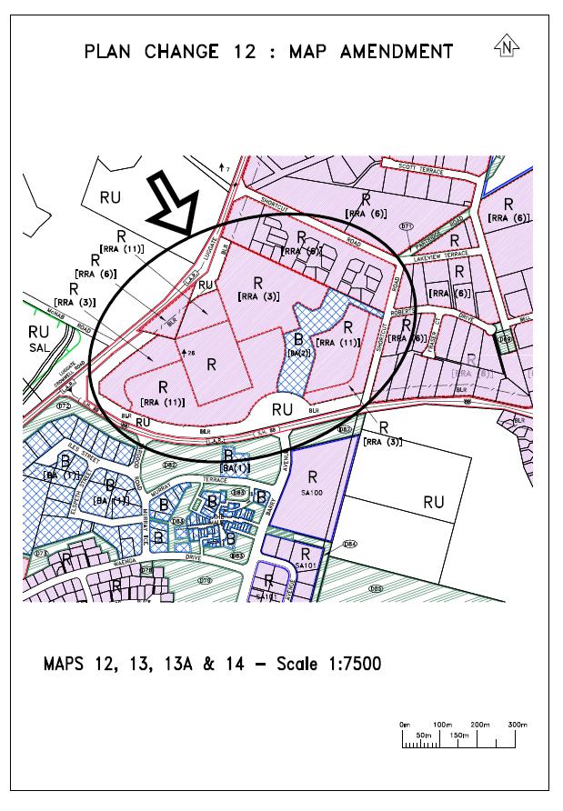
1 Annex 1 RESOURCE MANAGEMENT ACT 1991 CENTRAL OTAGO DISTRICT PLAN PLAN CHANGE 12 : WOOING TREE, CROMWELL 1. Amend Section 4 : Rural Resource Area of the Operative Central Otago District Plan by inserting a new Policy 4.4.2(h), a new Rule 4.7.5(vii) and a new Rule 4.7.6M to strongly discourage buildings in the Rural Resource Area in the Wooing Tree Overlay Area; to make such buildings a non-complying activity; and to stipulate that such land be maintained in either predominantly vineyard plantings or a treed park like character, a breach being a non-complying activity. 2. Amend Section 7 : Residential Resource Area of the Operative District Plan by: i) Amending Section 7.1 Objectives to confirm that the objectives relate to the Wooing Tree Overlay Area. ii) iii) iv) Amending the Explanation to Policy to confirm that the Residential Resource Area (3) and the Residential Resource Area (11) have also been applied to land within the Wooing Tree Overlay Area to manage interface effects between existing residential activities, the State Highways and new development. Inserting a new Rule 7.3.2(vi) to provide for multi-unit development in the Residential Resource Area of the Wooing Tree Overlay Area as a controlled activity; with a corresponding amendment to Rule 7.3.3(vi). Inserting a new Rule 7.3.2(vii) to provide for one care centre or community facility (limited to a childrens educational facility) in the Residential Resource Area (11) of the Wooing Tree Overlay Area as a controlled activity. v) Amending Rule 7.3.3(i)(c) to provide for: Any subdivision in the Residential Resource Area within the Wooing Tree Overlay Area to not exceed a maximum lot size of 350m2 and a total of 50 residential allotments. Any subdivision in the Residential Resource Area (3) within the Wooing Tree Overlay Area to not exceed 60 residential allotments. Any subdivision in the Residential Resource Area (11) within the Wooing Tree Overlay Area to not exceed 100 residential allotments. Amendments to be made to the Reason, accordingly. vi) vii) Inserting a new Rule 7.3.6(iii)(b)(iii) to stipulate a minimum front yard of 3 metres in the Residential Resource Area of the Wooing Tree Overlay Area. Inserting a new Rule 7.3.6(iii)(c)(iii) to stipulate minimum side and rear yards of 1.8 metres in the Residential Resource Area of the Wooing Tree Overlay Area
2 provided that no side yards are required for buildings adjoined by a common wall for a multi-unit development under new Rule 7.3.2(vi). viii) ix) Inserting a new Rule 7.3.6(iii)(iv) to require a 15 metre yard in the Residential Resource Area (3) adjacent to the north-eastern boundary of the Wooing Tree Overlay Area. Amending Rule 7.3.6(iii)(f)(1) and inserting a new Rule 7.3.6(iii)(f)(5) to stipulate that no recession planes are required in the Residential Resource Area of the Wooing Tree Overlay Area for buildings which are adjoined by a common wall for multi-unit development under new Rule 7.3.2(vi). x) Amending Rule 7.3.6(iv) to stipulate in a new Rule 7.3.6(iv)(i) a maximum site coverage of 80% to apply within the Residential Resource Area of the Wooing Tree Overlay Area; and to amend the Reason, accordingly. xi) Amending Rule 7.3.6(vi) by inserting new Rules 7.3.6(vi)(d), (e) and (f) which relate to access within the Residential Resource Areas of the Wooing Tree Overlay Area as follows: (d) (e) (f) No vehicle access is permitted from the Wooing Tree Overlay Area to the State Highway except via a single lane roundabout (incorporating a 44m diameter central island as recommended by Ausroads Guide to Traffic Engineering) constructed at the corner of SH8B and Barry Avenue. No new development (other than a new temporary access from the existing Wooing Tree Tasting Room to Shortcut Road or internally within the property to a new road to access Shortcut Road) west of and including the Business Resource Area (2) of the Wooing Tree Overlay Area shall be permitted until the single lane roundabout referred to in Rule 7.3.6(vi)(d) and a pedestrian underpass is completed and operational. Development that is permitted to occur shall be designed to connect to the single lane roundabout referred to in Rule 7.3.6(vi)(d) as the primary access to the State Highway once completed and operational. Legal road access shall be included in the design of the subdivision so that Shortcut Road connects to the single lane roundabout referred to in Rule 7.3.6(vi)(d). xii) xiii) Inserting a cross reference which confirms that a breach of the new Rules 7.3.6(vi)(d)-(f) is a non-complying activity; and amending Rule by inserting a new Rule 7.3.5(vi), accordingly. Amending Rule 7.3.6(xii) by renumbering the existing rule as Rule 7.3.6(a), and by inserting a new Rule 7.3.6(xii)(b) to stipulate that new residential buildings in the Residential Resource Areas of the Wooing Tree Overlay Area within 80m of the seal edge of State Highway 6 and 8B are to be designed to meet noise performance standards as specified in the new Rule 7.3.6(xii)(b). 3. Amend Section 8 : Business Resource Area of the Operative District Plan by: i) Inserting a new Policy which relates to the Business Resource Area (2) of the Wooing Tree Overlay Area to provide for the development of high quality travellers accommodation and associated vineyard village themed retail and
3 commercial activities in a manner that complements other business areas at Cromwell; and to amend the Explanation which follows, accordingly. ii) iii) iv) Amending the Reason which relates to Rule 8.3.1(i) to insert reference to standards which relate to the Business Resource Area (2) of the Wooing Tree Overlay Area. Amending Rule 8.3.2(iv) to exclude provision for vehicle oriented activity as a controlled activity within the Business Resource Area (2) of the Wooing Tree Overlay Area. Inserting a new Rule 8.3.2(v) to provide for all buildings in the Business Resource Area (2) of the Wooing Tree Overlay Area as a controlled activity; and to insert a new Reason which relates to the new Rule 8.3.2(v). v) Amending Rule 8.3.6(i) by renumbering the existing Rule as Rule 8.3.6(a) and by inserting a new Rule 8.3.6(i)(b) to stipulate that the maximum area of a shop in the Business Resource Area (2) of the Wooing Tree Overlay Area is 200m 2. vi) vii) Amending Rule 8.3.6(ii) to require a yard of 15 metres adjacent to the north-east boundary of the Wooing Tree Overlay Area. Inserting a new Rule 8.3.6(xii) and associated Reason which relates to the Business Resource Area (2) of the Wooing Tree Overlay Area as follows: (xii) Access Within the Business Resource Area (2) of the Wooing Tree Overlay Area (a) No vehicle access is permitted from the Business Resource Area (2) of the Wooing Tree Overlay Area to the State Highway except via a single lane roundabout (incorporating a 44m diameter central island as recommended by Ausroads Guide to Traffic Engineering) constructed at the corner of SH8B and Barry Avenue. (b) No new development (other than a new temporary access from the existing Wooing Tree Tasting Room to Shortcut Road or internally within the property to a new road to access Shortcut Road) within the Business Resource Area (2) of the Wooing Tree Overlay Area shall be permitted to occur until the single lane roundabout referred to in Rule 8.3.6(xii)(a) and pedestrian underpass across the State Highway is completed and operational. Reason Development in these areas must not affect the safe and efficient operation of the State highway network. viii) Inserting a new Rule 8.3.6(xiii) which relates to the Business Resource Area (2) of the Wooing Tree Overlay Area as follows: (xiii) Maximum Floor Space within the Business Resource Area (2) of the Wooing Tree Overlay Area The maximum Floor Space (as defined) within the Business Resource Area (2) within the Wooing Tree Overlay Area shall be 12,000m 2 divided as follows:
4 (a) (b) (c) No more than 6,000m 2 of the permitted Floor Space shall be used for Travellers Accommodation; No more than 4,000m 2 of the permitted Floor Space shall be used for Shops; No more than 2,000m 2 of the permitted Floor Space shall be used for any activities that than Traveller s Accommodation or Shops. In addition to above, the maximum building coverage shall not exceed 8,000m 2 of the total Business Resource Area (2) area. ix) Inserting cross references which confirm that a breach of the new Rule 8.3.6(xii) and of the new Rule 8.3.6(xiii) is a non-complying activity; and amending Rule 8.3.5(ii) accordingly. 4. Amend Section 18 Definitions by inserting new definitions as follows: External Appearance in relation to buildings the Business Resource Area (2) of the Wooing Tree Overlay Area, means the bulk and shape of the building including roof pitches, the materials of construction and the colour of exterior walls. Urban Design in relation to the layout of buildings the Business Resource Area (2) of the Wooing Tree Overlay Area, means the matters contained in the New Zealand Design Protocol (2005) or any amendments thereof. Wooing Tree Overlay Area/Wooing Tree Overlay means the land bounded by Shortcut Road and State Highway 6 and 8B at Cromwell that is legally described as Section 3 SO Amend Schedule 19.4 Register of Heritage Buildings, Places, Sites and Objects and Notable Trees to include a new item being Notable Tree No 26 being a Monterey Pine (Pinus radiata) known as the Wooing Tree that is located in the Wooing Tree Overlay Area. 6. Amend Planning Maps 12, 13, 13A and 14 to rezone land in the Wooing Tree Overlay Area being Section 3 SO from Residential Resource Area (6) to Residential Resource Area, Residential Resource Area (3), Residential Resource Area (11), Business Resource Area (2) and Rural Resource Area. The existing Building Line Restriction is to be amended to provide a greater depth adjacent to the location of a future single lane roundabout; and the Monterey Pine (Pinus radiata) known as the Wooing Tree is to be shown by notation as Notable Tree No 26 on Planning Map 13. Notes: 1. New text to be inserted (as presented in quotation marks) is underlined. 2. For full details of text amendments see Attachment F to the plan change request document entitled Wooing Tree Holdings Limited Private Plan Change to the Central Otago Operative District Plan Application, Section 32 Evaluation and Assessment of Effects on the Environment prepared by Vivian + Espie Limited and dated 13 March Leanne Mash Chief Executive
5
4 Residential and Urban Living Zones
 4 Residential and Urban Living Zones Refer to Chapters 11 to 20 for additional rules that may apply to these zones. 4.1 OBJECTIVES AND POLICIES Objective Res1 Policy 1 Policy 2 Policy 3 Policy 4 Policy
BEFORE THE CENTRAL OTAGO DISTRICT COUNCIL
 BEFORE THE CENTRAL OTAGO DISTRICT COUNCIL IN THE MATTER OF Proposed Plan Change 12 to the Central Otago District Plan ON BEHALF OF Wooing Tree Holdings Limited Requestor EVIDENCE OF BENJAMIN ESPIE (LANDSCAPE
64 Mineral Extraction Area Rules
 64 Mineral Extraction Area Rules 64.1 Introduction For the purposes of this Chapter: Active Area, in relation to a Mineral Extraction Area (MEA), is that part of the Mineral Extraction Area which is owned
open space environment
 This section updated August 09 GUIDELINE TO THE RULES The Open Space Environment Rules apply to activities on sites within the Open Space Environment as shown on the Human Environments Maps. Most of the
HAMILTON CITY COUNCIL PROPOSED DISTRICT PLAN NOVEMBER 2001 (REFERENCES VERSION) Proposed Variation No.7: Temple View Rezoning
 Proposed Variation No.7: Temple View Rezoning") HAMILTON CITY COUNCIL PROPOSED DISTRICT PLAN NOVEMBER 2001 (REFERENCES VERSION) Proposed Variation No.7: Temple View Rezoning 1.0 Purpose of the Variation APPENDIX 1 On 1 July 2004 the Temple View area
HAMILTON CITY COUNCIL PROPOSED DISTRICT PLAN NOVEMBER 2001 (REFERENCES VERSION) Proposed Variation No.7: Temple View Rezoning 1.0 Purpose of the Variation APPENDIX 1 On 1 July 2004 the Temple View area
I615. Westgate Precinct
 I615. Westgate Precinct I615.1. Precinct Description The Westgate Precinct is located approximately 18km west of the Auckland city centre. There are seven Sub-precincts in the Westgate Precinct: Sub-precinct
I403 Beachlands 1 Precinct
 I403. Beachlands 1 I403.1. Precinct Description Beachlands is a rural and coastal village located on the eastern side of Auckland, adjoining the Tamaki Strait coastline. The original Beachlands village
D18. Special Character Areas Overlay Residential and Business
 D18 Overlay Residential and Business D18. Overlay Residential and Business D18.1. Background The Overlay Residential and Business seeks to retain and manage the special character values of specific residential
49 Scheduled Activities
 49 Scheduled Activities 49.1 Rules Explanation The rules for scheduled activities take precedence over the other rules for the Environment in which the scheduled activity is located. This means that, where
Bylaw A Bylaw to amend Bylaw 12800, as amended, The Edmonton Zoning Bylaw Amendment No. 2239
 Bylaw 17672 A Bylaw to amend Bylaw 12800, as amended, The Edmonton Zoning Bylaw Amendment No. 2239 WHEREAS City Council at its meeting of February 22, 2001, gave third reading to Bylaw 12800, as amended;
15 Rural Residential Zone
 15 Rural Residential Zone Section 15A 15A Purpose of the Rural Residential Zone... 1 15A.1 Objectives and Policies of the Rural Residential Zone... 1 15A.2 Activity Status Rules... 5 15A.3 Permitted Activity
SPECIAL 35 (HIBISCUS COAST GATEWAY) ZONE
 ZONE") `` 12.8.35 SPECIAL 35 (HIBISCUS COAST GATEWAY) ZONE 12.8.35.1 Issues The following provisions relate to the Hibiscus Coast Gateway Zone. This zone is located at Silverdale in the area bounded by State
`` 12.8.35 SPECIAL 35 (HIBISCUS COAST GATEWAY) ZONE 12.8.35.1 Issues The following provisions relate to the Hibiscus Coast Gateway Zone. This zone is located at Silverdale in the area bounded by State
11.3 SPECIAL CHARACTER ZONE HAWKE S BAY REGIONAL SPORTS PARK
 11.3 SPECIAL CHARACTER ZONE HAWKE S BAY REGIONAL SPORTS PARK 11.3.1 INTRODUCTION The availability of sports and recreation activities and facilities is important for the maintenance and enhancement of
FRANKTON FLATS (B) ZONE - RULES
 ZONE - RULES") .19.3 Implementation Methods.19.3.1 District Plan and Other Methods The Objectives and Policies will be implemented through: i District Plan Specific Zone rules, including the use of the Structure Plan
.19.3 Implementation Methods.19.3.1 District Plan and Other Methods The Objectives and Policies will be implemented through: i District Plan Specific Zone rules, including the use of the Structure Plan
Urban Design Brief December 23, 2015 Southside Construction Group Official Plan & Zoning By-Law Amendment
 Urban Design Brief Proposed Official Plan & Zoning By-Law Amendment 3244, 3263 and 3274 Wonderland Road South Southside Group December 23, 2015 TABLE OF CONTENTS Page No. INTRODUCTION... 1 SECTION 1 LAND
Heritage Precincts Overlay
 Rule 2.4 Heritage Precincts Overlay Rule Statement Heritage Precincts are areas with consistent special heritage character. The District Plan has identified fourthree Heritage Precincts, the Frankton Railway
LIST OF TABLES, FIGURES AND APPENDICES
 LIST OF TABLES, FIGURES AND APPENDICES Chapter Page 2 INTERPRETATION FIGURE 2.1 SAMPLE AWNING...2.8 FIGURE 2.2 SAMPLE LOW-RISE APARTMENT DESIGN...2.9 FIGURE 2.3 SAMPLE DUPLEX DESIGN...2.10 FIGURE 2.4 SAMPLE
APPENDIX C. Architectural and Environmental Design Standards. Environmentally sensitive areas should be protected.
 APPENDIX C Architectural and Environmental Design Standards Environmentally Sensitive Areas Goal A. Environmentally sensitive areas should be protected. Development, such as roads, houses, and other structures,
DESIGN GUIDELINES FOR: INTENSIVE RESIDENTIAL DEVELOPMENT TOWNHOUSE AND ROWHOUSE
 DESIGN GUIDELINES FOR: INTENSIVE RESIDENTIAL DEVELOPMENT TOWNHOUSE AND ROWHOUSE 1. Introduction Townhouse and Rowhouse Building Typologies Within these guidelines, the term rowhouse means a single row
I422. Māngere Gateway Precinct
 I422. Māngere Gateway Precinct I422.1. Precinct description The Māngere Gateway Precinct is comprised of land generally north of the Auckland International Airport and west of George Bolt Memorial Drive
PUBLIC HEARING May 18, 2010 SUMMARY AND RECOMMENDATION
 PUBLIC HEARING May 18, 2010 SUMMARY AND RECOMMENDATION 7. REZONING: 5912-5970 Oak Street Summary: To rezone from RS-1 (single-family) to Comprehensive Development (CD-1) District to permit a 27-unit townhouse
QLDC PROPOSED DISTRICT PLAN [PART SIX] DECISIONS VERSION 42 waterfall park
![QLDC PROPOSED DISTRICT PLAN [PART SIX] DECISIONS VERSION 42 waterfall park](/thumbs/96/126991214.jpg "QLDC PROPOSED DISTRICT PLAN [PART SIX] DECISIONS VERSION 42 waterfall park") 42 WATERFALL PARK 42.1 Purpose The purpose of the Waterfall Park Zone is to provide for the development of a visitor resort comprising a range of visitor, residential and recreational facilities, sympathetic
42 WATERFALL PARK 42.1 Purpose The purpose of the Waterfall Park Zone is to provide for the development of a visitor resort comprising a range of visitor, residential and recreational facilities, sympathetic
BRAMPTON FLOWERTOWN SECONDARY PLAN Area 6
 BRAMPTON FLOWERTOWN SECONDARY PLAN Area 6 October 2018 EXPLANATORY NOTES Brampton Flowertown Secondary Plan Area 6 General i. Secondary plans form part of the Official Plan and are to be read in conjunction
CONCEPT BRIEF. 101 West Abram Street Arlington, Texas
 CONCEPT BRIEF 101 West Abram Street Arlington, Texas 76010 817-459-6502 www.arlingtontx.gov/planning PD13-18 Case Number: Form must be filled out completely. Please type or legibly print all information.
DAVENPORT VILLAGE SECONDARY PLAN
 27 DAVENPORT VILLAGE SECONDARY PLAN 27. DAVENPORT VILLAGE SECONDARY PLAN 1. VISION FOR THE DAVENPORT VILLAGE SECONDARY PLAN Davenport Village, municipally known as 830, 940, 980 and 1100 Lansdowne Avenue,
Official Community Plan Bylaw No. 4360, 2004, Amendment Bylaw No. 4897, 2016 (Sewell s Landing)
") District of West Vancouver Official Community Plan Bylaw No. 4360, 2004, Amendment Bylaw No. 4897, 2016 (Sewell s Landing) Effective Date: 1089612v1 District of West Vancouver Official Community Plan Bylaw
District of West Vancouver Official Community Plan Bylaw No. 4360, 2004, Amendment Bylaw No. 4897, 2016 (Sewell s Landing) Effective Date: 1089612v1 District of West Vancouver Official Community Plan Bylaw
SECTION 7A: WHAKARONGO RESIDENTIAL AREA
 SECTION 7A: WHAKARONGO RESIDENTIAL AREA CONTENTS 7A.1 Introduction 1 7A.2 Resource Management Issues 1 7A.3 Objectives and Policies 1 7A.4 Methods 4 7A.5 Residential Zone 4 7A.5.1 Rules: Controlled Activities
PRIVATE PLAN CHANGE REQUEST REZONING OF LAND AT 49, 57 AND 71 MILL ROAD FROM RURAL 3 ZONE TO MAIN RESIDENTIAL ZONE. Amendments to:
 PRIVATE PLAN CHANGE REQUEST REZONING OF LAND AT 49, 57 AND 71 MILL ROAD FROM RURAL 3 ZONE TO MAIN RESIDENTIAL ZONE Amendments to: MANUKAU OPERATIVE DISTRICT PLAN 2002 AUCKLAND REGIONAL POLICY STATEMENT
Final Master Plan and Development Control Regulations
 1. INTRODUCTION CHECK LIST a. Introduction b. Table of contents c. Definitions. d. scope of works. 2. FINAL OVERALL MASTER PLAN a. SITE ANALYSIS and OVERVIEW: i. Existing and Proposed Site Plan Levels.
I505. Chelsea Precinct
 I505. Chelsea Precinct I505.1. Precinct Description This precinct covers land and water areas owned and/or formerly used by the Chelsea Sugar Refinery at Birkenhead. Chelsea Estate Heritage Park is owned
6 PORT SYDNEY SETTLEMENT AREA
 Section 6 Port Sydney Page 61 6 PORT SYDNEY SETTLEMENT AREA 6.1 Basis and Principles Village of Port Sydney Waterfront Community Existing Services 6.1.1 Port Sydney is an historic settlement that has developed
I209 Quay Park Precinct
 I209. Quay Park I209.1. Precinct description The Quay Park Precinct is located on reclaimed land at the eastern end of the city centre and along the City Centre waterfront. It is dissected to the east
the Resource Management Act 1991 ( RMA ) Private Plan Change (PC135) at Marsden Primary Centre by GNLC Limited
 Private Plan Change (PC135) at Marsden Primary Centre by GNLC Limited") BEFORE THE WHANGAREI DISTRICT COUNCIL UNDER the Resource Management Act 1991 ( RMA ) AND IN THE MATTER OF Private Plan Change (PC135) at Marsden Primary Centre by GNLC Limited REPLY SUBMISSIONS FOR GNLC
BEFORE THE WHANGAREI DISTRICT COUNCIL UNDER the Resource Management Act 1991 ( RMA ) AND IN THE MATTER OF Private Plan Change (PC135) at Marsden Primary Centre by GNLC Limited REPLY SUBMISSIONS FOR GNLC
TOWN OF HALTON HILLS OFFICIAL PLAN AMENDMENT 10 PROPOSED MODIFICATIONS. Premier Gateway Employment Lands Re-Phasing. to implement
 TOWN OF HALTON HILLS OFFICIAL PLAN AMENDMENT 0 PROPOSED MODIFICATIONS Premier Gateway Employment Lands Re-Phasing to implement Halton Peel Boundary Area Transportation Study/ GTA West Corridor Protection
AMENDMENTS. Date Effective. Amendment No. Council. DCP 14 Davidson St, Greenacre Page 2
 AMENDMENTS Amendment No. Description Adopted by Council Date Effective DCP 14 Davidson St, Greenacre Page 2 TABLE OF CONTENTS 1.0 INTRODUCTION... 4 1.1 NAME OF THIS PLAN... 4 1.2 COMMENCEMENT OF DEVELOPMENT
SCHEDULE 12 TO THE DESIGN AND DEVELOPMENT OVERLAY GLEN WAVERLEY ACTIVITY CENTRE STRUCTURE PLAN
 DD/MM/YY Proposed C120 SCHEDULE 12 TO THE DESIGN AND DEVELOPMENT OVERLAY Shown on the planning scheme map as DDO12. GLEN WAVERLEY ACTIVITY CENTRE STRUCTURE PLAN 1.0 Design objectives DD/MM/YY Proposed
Ensure that development within the Arrowtown Urban Growth Boundary provides:
 URBAN DEVELOPMENT 4 4.2.5.2 Ensure that development within the Arrowtown Urban Growth Boundary provides: an urban form that is sympathetic to the character of Arrowtown, including its scale, density, layout
VIEW SHAFTS. Figure 32: Existing view shafts which are to be protected and enhanced and desirable new view shafts ANNEX 2
 VIEW SHAFTS 2.9.1 Sight lines, both from within the Viaduct Harbour area, and into the area from without, are a vital component of the character of the area. They are also an invaluable means by which
TOWN OF HALTON HILLS OFFICIAL PLAN AMENDMENT 10 PROPOSED MODIFICATIONS. Premier Gateway Employment Lands Re-Phasing. to implement
 TOWN OF HALTON HILLS OFFICIAL PLAN AMENDMENT 0 PROPOSED MODIFICATIONS Premier Gateway Employment Lands Re-Phasing to implement Halton Peel Boundary Area Transportation Study/ GTA West Corridor Protection
SHOTOVER COUNTRY SPECIAL ZONE - RULES Shotover Country Special Zone - Rules
 .30 Shotover Country Special Zone - Rules.30 Shotover Country Special Zone Rules.30.1 Zone Purpose The purpose of the zone is to establish a comprehensively designed and integrated living environment that
Section 12C Subdivision in the Rural Residential Zone
 Section 12C 12C Subdivision in the Rural Residential Zone The Rural Residential Zone provides part of the range of residential opportunities within the City. Land zoned rural residential is considered
To Adopt Amendment Number OP2006- to the Official Plan of the City of Brampton Planning Area
 To Adopt Amendment Number OP2006- to the Official Plan of the City of Brampton Planning Area The Council of The Corporation of the City of Brampton, in accordance with the provisions of the Planning Act,
I404 Beachlands 2 Precinct
 I404. Beachlands 2 I404.1. Precinct Description The Beachlands 2 precinct covers approximately 6 hectares of land at the corner of Beachlands and Whitford Maraetai Roads. Its purpose is to provide for
Subdivision Design Criteria. Penihana North GUIDELINES TO THE RULES
 Created September 2013 Penihana North Subdivision Design Criteria GUIDELINES TO THE RULES This part of the Plan sets out the design criteria for subdivision in Penihana North. The criteria will be considered
OFFICE CONSOLIDATION CHAPTER 47 HIGHWAY 427 INDUSTRIAL SECONDARY PLAN
 OFFICE CONSOLIDATION CHAPTER 47 HIGHWAY 427 INDUSTRIAL SECONDARY PLAN NOTE: This Secondary Plan is partially in effect. Highlighted sections are under appeal. August 2017 1 EXPLANATORY NOTE Office Consolidation
Urban Design Brief Fanshawe Park Road. Competition Toyota
 Urban Design Brief 1300 Fanshawe Park Road Competition Toyota May 2, 2014 TABLE OF CONTENTS Page No. INTRODUCTION... 1 SECTION 1 LAND USE PLANNING CONTEXT... 1 1.1 The Subject Lands... 1 1.2 The Proposal...
I611. Swanson North Precinct
 I611. Swanson North Precinct I611.1. Precinct Description Swanson North is located in the north eastern foothills of the Waitakere Ranges. It is outside the Waitakere Ranges Heritage Area Act and the Waitakere
Urban Design Brief Woodland Cemetery Funeral Home 493 Springbank Drive
 Urban Design Brief Woodland Cemetery Funeral Home The Incorporated Synod of the Diocese of Huron April 15, 2016 Urban Design Brief April 15, 2016 TABLE OF CONTENTS Page No. INTRODUCTION... 1 SECTION 1
ORDINANCE AN ORDINANCE TO ADD A NEW SECTION 4.N. IN THE ZONING CODE FOR THE TOWN OF MIDDLETOWN, RELATING TO MIXED-USE DEVELOPMENT
 Introduced: November 5, 2018 Approved: ORDINANCE 18-11-01 AN ORDINANCE TO ADD A NEW SECTION 4.N. IN THE ZONING CODE FOR THE TOWN OF MIDDLETOWN, RELATING TO MIXED-USE DEVELOPMENT BE IT ENACTED BY THE MAYOR
Auckland City Operative District Plan (Isthmus 1999) Private Plan Change: Three Kings Precinct PA372
 Private Plan Change: Three Kings Precinct PA372") Auckland City Operative District Plan (Isthmus 1999) Private Plan Change: Three Kings Precinct Under Part 2 of Schedule 1 of the Resource Management Act 1991 PA372 1 2 3 Part C: Insert the following in
Auckland City Operative District Plan (Isthmus 1999) Private Plan Change: Three Kings Precinct Under Part 2 of Schedule 1 of the Resource Management Act 1991 PA372 1 2 3 Part C: Insert the following in
TABLE OF CONTENTS 1.0 INTRODUCTION... 3
 TABLE OF CONTENTS 1.0 INTRODUCTION... 3 1.1. BACKGROUND... 3 1.2. THE PROPOSAL... 5 2.0 EXISTING POLICY FRAMEWORK... 5 2.1. PROVINCIAL POLICY STATEMENT (PPS)... 5 2.2. CITY OF LONDON OFFICIAL PLAN (OP)...
141 GEORGE STREET PLANNING RATIONALE
 141 GEORGE STREET PLANNING RATIONALE MINOR ZONING BY-LAW AMENDMENT NOVEMBER 2, 2016 PLANNING RATIONALE 223 McLeod Street Ottawa, ON K2P 0Z8 613.730.5709 fotenn.com INTRODUCTION FOTENN Consultants is acting
Chapter 5 Urban Design and Public Realm
 5.1 Introduction Public realm is all areas of the urban fabric to which the public have access. It is where physical interaction takes place between people. It therefore, includes buildings and their design,
I207. Learning Precinct
 I207. Learning Precinct I207.1. Precinct description The Learning Precinct is centred on the Symonds Street ridge where the University of Auckland and Auckland University of Technology have the majority
COMMISSION REGULATION (EU) / of
 / of") EUROPEAN COMMISSION Brussels, 30.11.2016 C(2016) 7767 final COMMISSION REGULATION (EU) / of 30.11.2016 amending Regulations (EC) No 1275/2008, (EC) No 107/2009, (EC) No 278/2009, (EC) No 640/2009, (EC)
EUROPEAN COMMISSION Brussels, 30.11.2016 C(2016) 7767 final COMMISSION REGULATION (EU) / of 30.11.2016 amending Regulations (EC) No 1275/2008, (EC) No 107/2009, (EC) No 278/2009, (EC) No 640/2009, (EC)
I334. Wairaka Precinct
 I334. Wairaka Precinct I334.1. Precinct Description The Wairaka Precinct extends from the north western motorway at Point Chevalier in the north, through to Woodward Road in the south, and from Oakley
This table identifies new provisions sought to be added:
 Chapter 16 Business Mixed Use This table identifies new provisions sought to be added: Appellant Court Number FII Holdings Limited ENV-2018-CHC-084 FII Holdings Limited ENV-2018-CHC-084 Universal Developments
Yellowhead Corridor Area Structure Plan
 Yellowhead Corridor Area Structure Plan Office Consolidation June 2014 Prepared by: Current Planning Branch Sustainable Development City of Edmonton Bylaw 7044, as amended, was adopted by Council in April
SECTION UNIFIED DEVELOPMENT ORDINANCE SECTION Part 1 Ordinance. ARTICLE 1 Zoning Districts
 SECTION 1-100 UNIFIED DEVELOPMENT ORDINANCE SECTION 1-300 Part 1 Ordinance SECTION 1-100. Introduction. ARTICLE 1 Zoning Districts Crystal Lake strives to maintain a balance of various land uses for a
AMENDMENT NO. 42 TO THE OFFICIAL PLAN OF THE TOWN OF GRIMSBY
 AMENDMENT NO. 42 TO THE OFFICIAL PLAN OF THE TOWN OF GRIMSBY INITIATED BY TOWN OF GRIMSBY TABLE OF CONTENTS PART I: THE CERTIFICATION Certification Page Adopting By-law of the Town of Grimsby PART II:
STAFF REPORT DEVELOPMENT COMMISSION ZONING MEETING CITY OF COLUMBUS, OHIO JANUARY 10, 2019
 STAFF REPORT DEVELOPMENT COMMISSION ZONING MEETING CITY OF COLUMBUS, OHIO JANUARY 10, 2019 5. APPLICATION: Z18-063 Location: 4053 WEST BROAD STREET (43228), being 6.42± acres located at the southeast corner
Mark-up of the effect of the proposed Bronte Village Growth Area OPA No.18 on the text of section 24, Bronte Village, of the Livable Oakville Plan
 Mark-up of the effect of the proposed Bronte Village Growth Area OPA No.18 on the text of section 24, Bronte Village, of the Livable Oakville Plan Notes: This document is provided for information purposes
LOS ANGELES CITY PLANNING DEPARTMENT STAFF REPORT
 LOS ANGELES CITY PLANNING DEPARTMENT STAFF REPORT LOS ANGELES CITY PLANNING COMMISSION CASE NO: CPC 2006-9374 CRA CEQA: Exempt DATE: December 21, 2006 Location: Valley Plaza and Laurel Plaza TIME: after
Rezoning. Rezone from C-4 and RA to RF-9C and RF-12C to allow subdivision into approximately 47 small single family lots in East Clayton.
 City of Surrey PLANNING & DEVELOPMENT REPORT File: 7903-0275-00 Rezoning Proposal: Rezone from C-4 and RA to RF-9C and RF-12C to allow subdivision into approximately 47 small single family lots in East
Section 18A Purpose of the Industrial Zones
 Section 18A 18A Purpose of the Industrial Zones The purpose of the Industrial Zones is to provide consolidated areas that are strategically located near higher order roads, rail lines and shipping routes
Proposed Southland District Plan 2012 Appeal Version October 2016
 S e c t i o n 3. 5 - F i o r d l a n d / R a k i u r a Z o n e The Fiordland/Rakiura Zone encompasses the Fiordland and Rakiura National Parks and part of Mt Aspiring National Park. It also includes areas
I511. Hatfields Precinct
 I511. Hatfields Precinct I511.1. Precinct Description The Hatfields Precinct is a contiguous 183.8 hectare block of rural land held in 8 freehold titles, located immediately to the north of Hatfields Beach.
6 RURAL RESIDENTIAL. 6.1 Rural Use. Rural Use (RU) Goals and Objectives. Policy Goal
 Goals and Objectives. Policy Goal") 6 RURAL RESIDENTIAL The vast majority of East Hants 466,426 acres are considered rural in nature and are characterized by a great diversity of uses. Because of this, land use policies in rural areas of
6 RURAL RESIDENTIAL The vast majority of East Hants 466,426 acres are considered rural in nature and are characterized by a great diversity of uses. Because of this, land use policies in rural areas of
Draft Urban Hamilton Official Plan. Amendment No. XX
 1 of 75 The following text, together with: Draft Appendix A Centennial Neighbourhoods Secondary Plan Appendix B Volume 1, Schedule E-1 Urban Land Use Designations Appendix C Volume 1, Appendix A Parks
APPENDIX MATAKANA COMMERCIAL URBAN DESIGN GUIDELINES
 APPENDIX MATAKANA COMMERCIAL URBAN DESIGN GUIDELINES 1.0 INTRODUCTION The following urban design guidelines are to be utilised by landowners, planners and other persons involved in development at early
Be it enacted by the Town Board of the Town of Guilderland that the following new A (Transit Oriented Development (TOD) District) is adopted:
 District) is adopted:") Local Law No. 4 of 2018 (Adoption of 280-18A (Transit Oriented Development District) Be it enacted by the Town Board of the Town of Guilderland that the following new 280-18A (Transit Oriented Development
Local Law No. 4 of 2018 (Adoption of 280-18A (Transit Oriented Development District) Be it enacted by the Town Board of the Town of Guilderland that the following new 280-18A (Transit Oriented Development
5.0 VILLAGE AREAS. February 2008 Municipality of West Elgin ~ Official Plan 5-1
 5.0 VILLAGE AREAS This section of the Official Plan deals with the villages of Rodney and West Lorne being the two largest and only fully serviced settlement areas in West Elgin and the most logical and
Section Three, Part 16 Takanini Structure Plan Area
 PART 16 TAKANINI STRUCTURE PLAN AREA 16.1 Residential 8 zone 16.1.1 Objectives and Policies 16.1.2 Rules: General 16.1.3 Rules: Activity Status Subdivision (Except within the Addison Neighbourhood Centre)
Development Control Plan
 Development Control Plan Rhodes Corporate Park (Also known as the Digital Site) Development Control Plan Date of Adoption: 4 September 2007 Effective Date: 7 March 2008 Index 1 INTRODUCTION... 3 1.1 LAND
5.1 Commercial and Industrial Development. (Effective April 1, 2006)
") 5.1 Commercial and Industrial Development. (Effective April 1, 2006) A. Applicability: The requirements of this section (5.10) shall apply to all uses within the LB Local Business; HB Highway Business;
5.1 Commercial and Industrial Development. (Effective April 1, 2006) A. Applicability: The requirements of this section (5.10) shall apply to all uses within the LB Local Business; HB Highway Business;
I539. Smales 2 Precinct
 I539. Smales 2 Precinct I539.1. Precinct Description The Smales 2 Precinct applies to a 4.8 hectare block of land located on the southern side of Northcote Road and fronting Lake Pupuke, Takapuna. The
Proposed Amendments to the Ramsay Area Redevelopment Plan (ARP)
") CPC 2008 December 11 M-2008-050 APPENDIX I Page 1 Proposed Amendments to the Ramsay Area Redevelopment Plan (ARP) 1. Delete existing Map 1 (entitled Action Plan Executive Summary) and substitute revised
CPC 2008 December 11 M-2008-050 APPENDIX I Page 1 Proposed Amendments to the Ramsay Area Redevelopment Plan (ARP) 1. Delete existing Map 1 (entitled Action Plan Executive Summary) and substitute revised
Rezoning. Rezone from A-1 to RH to create 9 suburban single family residential lots. Approval to Proceed
 City of Surrey PLANNING & DEVELOPMENT REPORT Rezoning Proposal: Rezone from A-1 to RH to create 9 suburban single family residential lots. Recommendation: Approval to Proceed Location: 18712 and Portion
A BILL FOR AN ORDINANCE TO AMEND CHAPTER 9, KAUAI COUNTY CODE 1987, RELATING TO STREET REQUIRE:MENTS FOR SUBDIVISIONS
 ORDINANCE NO. BILL NO. { vy"yj1j A BILL FOR AN ORDINANCE TO AMEND CHAPTER 9, KAUAI COUNTY CODE 1987, RELATING TO STREET REQUIRE:MENTS FOR SUBDIVISIONS BE IT ORDAINED BY THE COUNCIL OF THE COUNTY OF KAUA'I,
Palmerston North City Council District Plan May 2018 INSTITUTIONAL ZONE Introduction Resource Management Issues 2
 SECTION 19: INSTITUTIONAL ZONE CONTENTS 19.1 Introduction 1 19.2 Resource Management Issues 2 19.3 Objectives and Policies 2 19.4 Rules: Permitted Activities 4 19.4.1 Institutional and Associated Ancillary
FRASER LANDS CD-1 GUIDELINES (BLOCKS 68 AND 69) Adopted by City Council April 1989
 Adopted by City Council April 1989") $1 City of Vancouver Land Use and Development Policies and Guidelines Community Services, 453 W. 12th Ave Vancouver, BC V5Y 1V4 F 604.873.7344 fax 873.7060 planning@city.vancouver.bc.ca FRASER LANDS CD-1
$1 City of Vancouver Land Use and Development Policies and Guidelines Community Services, 453 W. 12th Ave Vancouver, BC V5Y 1V4 F 604.873.7344 fax 873.7060 planning@city.vancouver.bc.ca FRASER LANDS CD-1
City of Surrey PLANNING & DEVELOPMENT REPORT. OCP Amendment of a portion from Suburban to Urban
 City of Surrey PLANNING & DEVELOPMENT REPORT File: 7911-0119-00 Planning Report Date: November 7, 2011 PROPOSAL: OCP Amendment of a portion from Suburban to Urban Rezoning from RA to RH and RF in order
11.4 Highway 400 North Employment Lands Secondary Plan
 11.4 Highway 400 North Employment Lands Secondary Plan APPROVED BY THE ONTARIO MUNICIPAL BOARD ON NOVEMBER 21, 2011 11.4.1 General 11.4.1.1. The following policies and Schedules A - I form Official Plan
Infill Residential Design Guidelines
 Infill Residential Design Guidelines Adopted March 23, 2004 Amended September 10, 2013 City of Orange Community Development Department Planning Division Phone: (714) 744-7220 Fax: (714) 744-7222 www.cityoforange.org
VILLAGE OF CLEMMONS PLANNING BOARD DRAFT STAFF REPORT. Single Family Residential, Townhomes
 VILLAGE OF CLEMMONS PLANNING BOARD DRAFT STAFF REPORT PETITION INFORMATION Docket # C-212 Staff Megan Ledbetter Petitioner(s) Peacehaven Development LLC Owner(s) Larry Jarvis, William Alexander and Peacehaven
DESIGN AND LANDSCAPE GUIDELINES FOR DEVELOPMENT
 DESIGN AND LANDSCAPE GUIDELINES FOR DEVELOPMENT IN THE SECOND SUPERVISORIAL DISTRICT (REVISED) ADOPTED BY RIVERSIDE COUNTY BOARD OF SUPERVISORS ON SEPTEMBER 15, 1998 REVISED OCTOBER 23, 1998 REVISED AUGUST
REFERENCE: 16/8568/ENQ Received: 25 October 2016 Accepted: 26 October 2016
 LOCATION: Allianz Park, Greenlands Lane, London, NW4 1RL REFERENCE: 16/8568/ENQ Received: 25 October 2016 Accepted: 26 October 2016 WARD(S): Mill Hill APPLICANT: Saracens Copthall Ltd. PROPOSAL: Extension
I609. Penihana North Precinct
 I609. Penihana North Precinct I609.1. Precinct description The Penihana North Precinct is located south of the Swanson Railway Station, adjacent to the Rural Urban Boundary (RUB) and Waitakere Ranges Heritage
I412. Flat Bush Precinct
 I412. Flat Bush Precinct I412.1. Precinct description The Flat Bush precinct covers approximately 1730ha of land adjacent to the Rural Urban Boundary. The Flat Bush Precinct incorporates the provisions
Midtown Oakville will be a vibrant, transit-supportive, mixed use urban community and employment area.
 Livable Oakville Part E: Growth Areas, Special Policy Areas and Exceptions 20. MIDTOWN OAKVILLE 20.1 Goal The interchange of Trafalgar Road and the QEW and the Oakville GO Station are major entry points
Whenuapai Structure Plan Neighbourhood Design Statement
 Whenuapai Structure Plan Neighbourhood Design Statement Yvonne Weeber, Auckland Design Office, Auckland Council Version 2.1 June 2016 This report has been prepared by: Yvonne Weeber, Principal Urban Design,
Land at Hilton Depot, Hilton
 Policy H7: Land at Hilton Depot, Hilton 5.35 Land at Hilton Depot, Hilton lies to the south of Hilton. Hilton has seen considerable growth over the last 15 years due to the availability of brownfield land,
Proposed for Vic West Neighbourhood Plan. Design Guidelines for Intensive Residential Development - Townhouse and Attached Dwelling
 Proposed for Vic West Neighbourhood Plan Design Guidelines for Intensive Residential Development - Townhouse and Attached Dwelling Design Guidelines for Intensive Residential Development - Townhouse and
The purpose of the requirements in this Article is to provide for landscaping and screening of parking and other outdoor areas that will:
 XIII. LANDSCAPING & SCREENING A. Purpose The purpose of the requirements in this Article is to provide for landscaping and screening of parking and other outdoor areas that will: 1. Protect residential
4 RESIDENTIAL ZONE. 4.1 Background
 4 RESIDENTIAL ZONE 4.1 Background The residential areas within the City are characterised by mainly lowrise dwellings sited on individual allotments. Past architectural styles, settlement patterns and
MIDTOWN MIXED-USE VILLAGE. TECHNICAL DATA SHEET COMPONENT C-1 FOR PUBLIC HEARING - PETITION NUMBER Project No RZ1.1. Issued.
 N MIDTOWN MIXED-USE VILLAGE TECHNICAL DATA SHEET COMPONENT C- FOR PUBLIC HEARING - PETITION NUMBER 04-00 Project No. 496 Issued Revised SCALE: " = 0' N 0 0 0 40 RZ. c GENERAL PROVISIONS: a. SITE LOCATION.
I. Introduction. Prior Approvals
 Statement of Justification First National Bank 19790 Crystal Rock Drive, Germantown, Maryland Application for Site Plan and Limited Preliminary Plan Amendment I. Introduction DPH Architecture, for First
4. DOWNTOWN AND COMMERCIAL LAND USE DESIGNATIONS
 4. DOWNTOWN AND COMMERCIAL LAND USE DESIGNATIONS 4.1. DOWNTOWN DESIGNATION The Downtown is the primary multi-functional activity centre serving the City of London and the surrounding area, comprising much
Subdivision and Development
 Subdivision and Development 8.0 Introduction - Subdivision and Development The principle purpose of subdivision is to provide a framework for land ownership so that development and activities can take
City of Redlands Architectural Guidelines for Non-Residential Development
 14. Building articulation shall be included in the design of building, in order to create a formal entry statement. Avoid this Do this Page 11 15. Give special attention to creating pedestrian scale and